
Stream Barrier Removal: Are New Approaches Possible in Small Rivers? The Case of the Selho River (Northwestern Portugal)


Department of Geography and Communication and Society Research Centre (CECS), University of Minho, 4710-057 Braga, Portugal
*
Author to whom correspondence should be addressed.
Hydrology 2023, 10(8), 163; https://0-doi-org.brum.beds.ac.uk/10.3390/hydrology10080163
Submission received: 20 June 2023
/
Revised: 23 July 2023
/
Accepted: 4 August 2023
/
Published: 9 August 2023
Abstract
:The identification and characterization of barriers to river continuity are essential for the preparation of an inventory of hydraulic infrastructure. To this end, it is necessary to define the main identifying and characterizing elements of hydraulic infrastructures and descriptors of ecological continuity, with information that can characterize them from the point of view of their impact on the watercourse. Several authors have defined decision criteria for the removal of existing hydraulic structures in watercourses and their application, reinforcing the environmental benefits of the elimination of these hydraulic structures. In the present work, we proposed to develop a methodology for the evaluation of barriers in the Selho River (Guimarães Municipality, Northwest Portugal), elaborating an Environmental Condition Index (ECI) based on hydromorphological, socioeconomical, and ecological criteria, which allowed the identification of 43 weirs, of which 95% revealed quality inferior to Good. Following the application of a decision support methodology for the removal of hydraulic structures, it was possible to determine that 16 of the 43 weirs evaluated could be subject to removal, 26 would be under conditioned removal, and only 1 would be able to remain unchanged.
1. Introduction
Rivers support some of the Earth’s richest biodiversity [1] and provide essential ecosystem services to society [2], but are often fragmented by barriers [3]. Rivers are one of the most threatened ecosystems in the world [4], especially affected by the longitudinal disconnection of the fluvial systems [5,6,7,8,9,10].
River barriers can be defined as physical artificial structures of any type or height that are likely to have an impact on river ecosystem longitudinal connectivity [11]. Barriers to longitudinal connectivity can be classified into six types based on key features and extent of habitat modification [12]: dams, weirs, sluices, culverts, fords, and ramps [13,14]. Recently, more attention has been directed towards smaller structures, which are less well understood and constitute a large percentage of the barriers in many river systems [15,16]. These are structures with head drops of up to 1.0 m during low flow and streams and rivers with mean flows of less than 1.0 m3/s [17]. In this work, we will focus on weirs—artificial obstructions that cause an increase in the water surface level in the watercourse for some, if not all, flow conditions [18], with less than 5 m height [12,13,14].
In 2020, AMBER, an EU research project, carried out extensive work on river barriers and recorded over 600,000 across Europe, 85% of which were small structures [13]. While much attention has historically been given to large dams [19,20], the potential importance of small barriers (<5 m) is increasingly being recognized [14,16,21,22,23,24]. Most low-head structures are unreported [25], and their number and location are consequently poorly known [16,26,27].
There is a wealth of scientific literature surrounding the multiple impacts of small river infrastructures [26,28,29]. The magnitude and direction of primary and secondary effects can vary considerably from site to site with barrier type and watershed characteristics [30,31,32,33,34,35,36]. The effect on connectivity depends particularly upon the location [37]. The effects of river infrastructure on native freshwater fish are particularly well documented in the literature [5,10,17,21,26,38,39,40,41,42,43,44,45,46,47,48,49,50,51,52,53,54,55,56,57,58,59,60,61,62,63]. Of all the environmental changes caused by river barriers, the disturbance of natural water flows is typically the most damaging [8,13,16,44,58,64,65,66,67,68,69,70]. Barriers can also alter sediment transport [64,71,72] and have a hugely negative impact on ecosystems and their processes [8,16,33,44,66,67,68,69,73,74,75,76,77,78,79,80,81,82,83,84,85,86,87,88,89,90,91]. Additionally, barriers often create conditions favorable to the establishment and expansion of non-native, invasive species [39,92] in the channel and adjacent riparian structures [29,72]. A number of studies have described how barriers impact stream processes and/or forms [33,36,39,93,94,95,96,97,98,99,100,101]. Indeed, the cumulative impact of multiple barriers along a river system is very difficult to assess [31].
Increasing concerns about these impacts has led to a growing call for the restoration of rivers through the removal of barriers [102,103]. The problem of how to remove structures in a systematic and cost-effective manner [11,14,29] is actual, and it is not surprising that it is often seen as a valuable form of restoration [37,104,105,106]. From an environmental point of view, removal represents the best solution in most cases and should always be the objective where feasible [17]. Where full removal is not possible, there are other options for reducing the impacts of structures [7,8,16,48,66,71,91,107,108,109,110,111,112,113,114,115,116,117,118,119,120]. However, many obsolete small river barriers remain in place, in part due to their historical and cultural significance and perceived insignificance in respect to river processes.
Strikingly, the extent of river connectivity remains little known for most European rivers, despite the fact that the concept of river continuity is enshrined in the European Union (EU) Water Framework Directive (WFD) [121]. Collectively, the negative impacts caused by small barriers can reduce the ecological status of the water body assigned under the WFD [17,31,122,123]. River continuity is a key environmental objective of EU legislations, especially the WFD and the EU Biodiversity Strategy for 2030 [17,122,124]. For a water body to be classified as of good ecological status, its hydromorphological condition must be such that the quality elements deviate only slightly from the reference conditions. This may involve removing barriers that prevent the river from reaching good status [8,18,31,44,68,69,93,112,125,126,127,128,129,130,131].
There are dozens of different barrier prioritization methods, which will typically consider not just barrier removal but also other options [37,132,133,134,135,136]. Opportunities for barrier removal depend on barrier typology, where they are located in the catchment, as well as their sizes, ages, conditions, and impacts [11]. Small structures are much more abundant [14] and also easier and cheaper to remove [11]. There is thus an increasing need for numerical tools to help decision-makers correctly allocate resources to prioritize restoration actions [137]. Removal of dams and weirs is a management tool that is increasingly being developed by an array of scientists, environmental organizations, and governmental actors [138]. We highlight the project AMBER, involved in the adaptive management of barriers in Europe [139], the scoring system called DAMROS—Dam Removal Opportunity Score [11]—which supports the shortlisting of applications for dam removal grants of European Open Rivers Programme, and the LANBIOEVA (“Landscape Biogeographical Evaluation”) methodology, applied to Mediterranean environments [140].
As far as barrier removal and/or adaptation is concerned, Portugal is lagging far be-hind. In 2016, the Minister of the Environment created a working group (WG) with the purpose of proposing a plan to remove the infrastructures that proved to be obsolete, for lack of any socio-economic function, and the respective criteria to be adopted [141]. Seven-thousand weirs and dams were counted, mostly very old, obsolete, and unused structures. Some projects were developed using probabilistic models of structural connectivity [142,143,144]. Bochechas [145] refers to the need to create bases for the inventory and characterization of barriers in water lines and the elaboration of a proposal for the creation of the National Cadastre of River Continuity.
Concerning the Selho River (northwestern Portugal), the information is very scarce. In the Hydrographic Region 2 Management Plan, this watercourse presents the Ecological State of “Bad” (The assessment of ecological status is based on the classification of various biological, chemical, physicochemical, and hydromorphological quality elements. Ecological status is classified into one of five classes—Excellent, Good, Fair, Mediocre, and Bad [146]. Significant pressures are quantified and associated with urban, agricultural, and industrial uses, responsible for the classification obtained [147]. Consequently, Guimarães Municipality, through its Landscape Lab [148], is committed and involved in the rehabilitation of this watercourse, as well as the other rivers within its territory. Between 2018 and 2020, researchers from the Center for Communication and Society Studies (University of Minho, Braga, Portugal) and the Landscape Lab (Guimarães, Portugal) developed the project “Inventory and Environmental Assessment of barriers in the Selho River” [149]. Based on this project, we have defined and discussed a methodology, which will be presented in this paper, to assess 43 identified infrastructural barriers, considering the feasibility of their removal and taking into account environmental aspects. Therefore, the objective of this work is to present the methodology implemented and field-tested on the Selho River, which is an innovative assessment method applied to small extent and highly fragmented rivers, with a highly anthropized catchment area, using the cross-referencing of an index (Environmental Condition Index—ECI) with the technical feasibility study. We consider that this methodology has the potential to be applied in existing rivers throughout Europe and in other parts of the world, with characteristics similar to those of the Selho River. For the case of the Selho River, we considered all types of barriers, highlighting the small weirs and following the Biodiversity Strategy for a focus primarily on “obsolete barriers”.
2. Materials and Methods
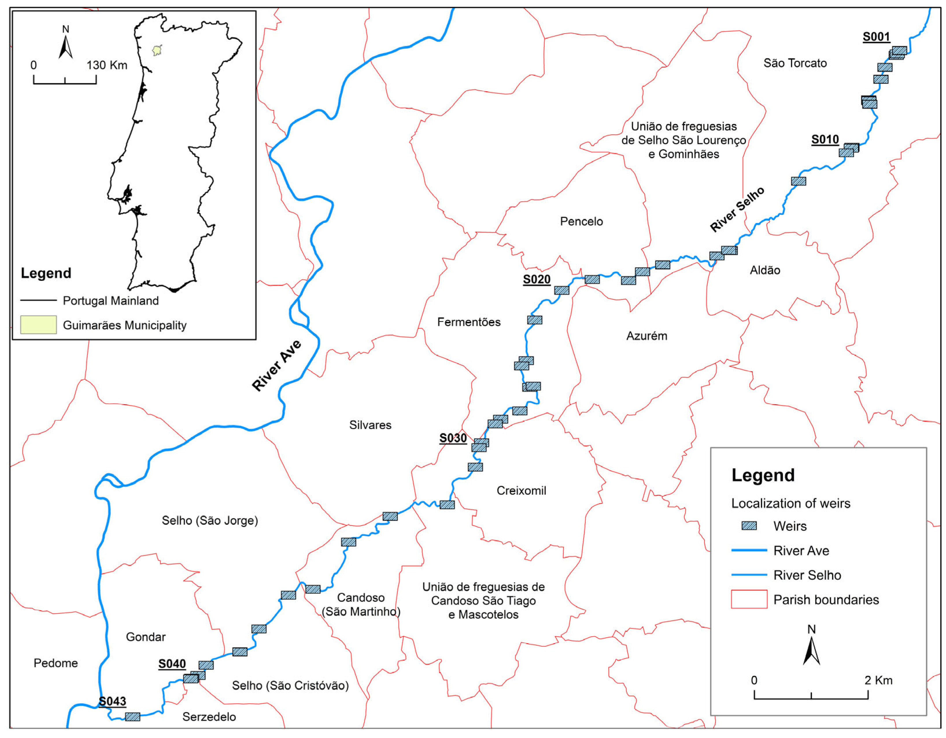
The Selho River basin is a sub-basin of the Ave River, with a predominant NE–SW direction. The area of this basin is 68 km2 and is located almost entirely in the Guimarães municipality. The Selho River runs for a distance of almost 21 km, resulting in a medium-low average slope of only 2.4% in its main course. Forty-three weirs were identified and located along the Selho River, distributed predominantly in the middle course of this watercourse (Figure 1).
The Project “Inventory and Environmental Assessment of barriers in the Selho River” lasted for 2 years (2018/2019) and was divided into 3 phases:
- –
- Phase 1—inventory preparation. Initially, we defined the data to be collected and included in the database to be built, taking into account the project objectives and identifying the barriers based on the implementation of geospatial technologies and preliminary visits to the Selho River [150,151,152,153].
In order to facilitate the fieldwork, we created a geodatabase (based on ESRI technology) that allowed for the survey of georeferenced data, the geometric characteristics of the barriers, and the hydrological, ecological, and economic–social conditions existing on the respective banks and riverbeds, in a 50 m buffer around the stream to the riparian zone.
The fieldwork took place during 6 months in the year 2019 and had the collaboration of students from the Masters in Geography of the University of Minho and joint coordination with the Landscape Lab (Figure 2).
To complete the inventory of barriers, we collected data on water quality parameters and geomorphological and hydraulic characteristics of the river in 2 periods—late spring and early fall—in order to ensure the best safety and mobility conditions along the banks and in the riverbed. With the collected data, we developed a supporting Geographic Information System (based on a spatial database) for the following phases. Robust priority setting and action planning required robust data [31], and, in this context, data integration in Geographic Information System (GIS) allowed for seamless analysis and visualization of results.
- –
- Phase 2—Creating a Multi-Criteria Index. We developed a matrix, adopting a multi-objective approach with several criteria and indicators selected and combining different assessment methods. The eco-hydrologic and social metrics are presented in a Multi-Criteria Index, which we called the Environmental Condition Index (ECI) and will allow us to infer the size of the impact caused by each barrier, as a first step to support the removal decision.
The selection of measurable criteria, indicators, and their values and weightings was based on an thorough search and analysis of specialized scientific works and articles from literature, national legislation, European directives (mainly the WFD), rules and regulations, reports, projects, and programs. A matrix following an organization chart of the assessment method was elaborated, in which we chose to apply a percentage to each criterion and a weighting index from 0 to 4 for the respective classes (Table 1, Table 2 and Table 3). As not all criteria had the same degree of importance, it seemed reasonable to consider differentiated weighting indexes to optimize the results. Here, the indicators were ranked based on an empirical evaluation of qualities and inputs.
We assessed each weir based on hydromorphological, ecological, and socioeconomic criteria and created an Environmental Condition Index (ECI), valuing each indicator and its classes qualitatively and quantitatively.
A maximum of five classes (0 to 4) were assigned to each criterion. Each class was related to a specific score, which varied according to the characteristics of the single criteria and its weighting. Class 4 of the classification referred to high-quality conditions (hydromorphological, ecological, and socio-economic), whereas class 0 referred to low-quality conditions. The scores of all assessed parameters were summed. The ECI value was computed as follows: ECI = hydromorphological criterion + ecological criterion + Socio-economic criterion. The score could range from 0 to 100. An index of 100 represented the maximum environmental condition within the investigated reach, whereas an index of 0 described minimum environmental conditions. Five environmental condition classes were defined, according to the WFD definitions. These classes ranged from Excellent to Bad and were defined as follows: 100–81 (Excellent), 80–61 (Good), 60–41 (Fair), 40–21 (Mediocre), and 20–0 (Bad) (Table 4).
With regard to the hydromorphological criterion, we assigned a total weight of 50%, taking into account the following indicators and classes:
- –
- Typology—the weirs were classified according to their heights (small dams or weirs), characteristics of their obstacles (wall/enclosure), and conditions (permanent/provisional). This followed the rules established in the Portuguese legislation, namely, in Decree-Law 21/2018 and in the Regulation of Small Dams, annexed to Decree-Law 409/93, of December 14, referring to small dams with a height of less than 10 m or with a height equal to or greater than 10 m and less than 15 m whose reservoirs have a storage capacity equal to or less than 1 hm3. Consequently, lower evaluation (0) was assigned to small dams (<10 m and >5 m) and higher (10) to provisional small structures (<1 m) made of wood or light materials (Table 1);
- –
- Body of water forming—we took into account the volume of the water retention that the barrier could promote and whether or not there was enough hydraulic slope to determine a waterfall or even allow free flow. We, therefore, assigned a value of 0 to barriers with a reservoir and 10 to those that did not interfere with river flow;
- –
- Passability—the height, slope, and construction characteristics of the weir were the elements considered to define the passability of fish species, which meant the existence of conditions to allow the passage of fish species upstream and downstream. Passability was dependent on several parameters (e.g., barrier height, water depth, barrier type, and presence of vertical drops) and varied depending on the swimming, jumping, and climbing capabilities of each fish species [13,154]. The attribution of values was according with the situation identified in each weir, considering the classes of “Unsurpassable” (value 0) to “Fully Transposable” (value 10);
- –
- Sediment accumulation—we measured sediment depth upstream of each barrier using a ½-inch Allen or a crow bar and, in some cases, using a probe. Higher evaluation was attributed to barriers with a small amount of or no sediment accumulation (7.5) and lower evaluation to the ones that promoted an accumulation superior to ¾ of the barrier height (0). Cases with sediment accumulation of about 50% of the height of the barrier were attributed a value of 1.875;
- –
- Erosion/sedimentation balance—we calculated the balance through the forms of erosion and sediment accumulation observed on the bed and banks, upstream and downstream of the weir. Considering the previous criteria evaluation, the erosion/sedimentation balance considered the relation of sediment accumulation both upstream and downstream of each barrier, the situations being considered with higher values when the barrier did not interfere with sediment flow (7.5), or when there was a balance on the sediments (5.625), and lower values when there was a significant difference between erosion and accumulation (0);
- –
- Downstream sediment loss—the classes were defined based on the relation between the sediments deposited/transported downstream of the barrier. The excessive transport of sediments downstream of the barrier was considered a negative factor, being valued with 0, whereas the maintenance of sediments was valued with 5;
- –
- Flow type—based on the observation of the current upstream of the barrier, we identified the type of flow according to those established in the reference works in fluvial geomorphology, with imperceptible flow valued at 0, and turbulent flow valued at 2.5.

Table 1.
Environmental Condition Index support matrix: hydromorphological criterion.
| Hydromorphological Criterion (50%) | Class | Weighting | Value | References |
|---|---|---|---|---|
| Typology (10%) | [11,13,17,141,145,155,156,157,158,159,160,161,162] | |||
| Small dam/wall | 0 | 0 | ||
| Rockfill Weir | 1 | 2.5 | ||
| Weir with sill/drain | 2 | 5 | ||
| Provisional | 4 | 10 | ||
| Body of water forming (10%) | [72,143,155,157,158,163,164,165] | |||
| Reservoir | 0 | 0 | ||
| Backwater | 1 | 2.5 | ||
| With waterfall | 2 | 5 | ||
| Without waterfall | 3 | 7.5 | ||
| Without interference | 4 | 10 | ||
| Passability (7.50%) | [72,143,155,159,160,162,165] | |||
| Unsurpassable | 0 | 0 | ||
| Difficult | 1 | 1.875 | ||
| With device/easily transposable | 3 | 5.625 | ||
| Fully Transposable | 4 | 7.5 | ||
| Sediment accumulation (7.50%) | [26,155,156,157,159,160,161,162,163,164,166,167,168,169] | |||
| Very high | 0 | 0 | ||
| Preponderant | 1 | 1.875 | ||
| Null/No interference | 4 | 7.5 | ||
| Erosion/sedimentation balance (7.50%) | [26,155,156,159,162,163,164,167,168] | |||
| Strongly unbalanced | 0 | 0 | ||
| Balanced | 3 | 5.625 | ||
| Imperceptible/not visible | 4 | 7.5 | ||
| Downstream sediment loss (5%) | [26,155,156,160,162,163,166,167,168] | |||
| High | 0 | 0 | ||
| Intermediate | 1 | 1.25 | ||
| No loss/insignificant | 4 | 5 | ||
| Flow type (2.50%) | [26,155,157,159,163,164,167] | |||
| Standing water/imperceptible | 0 | 0 | ||
| Laminar | 2 | 1.25 | ||
| Chaotic/turbulent | 4 | 2.5 | ||
To assess the ecological criteria, physico-chemical analysis of pH (Sorensen Scale), dissolved oxygen (% O2 saturation), and conductivity (µS/cm, 20 °C) was carried out. We also defined indicators on riparian vegetation, distinguishing the situation on the bank and on the bed, based on the species observed. We added the indicator “Solid waste”, defining the different classes, taking into account the amount, type, and area of deposition (beds and banks).
For pH, the classes were defined according to the following: Bad = pH > 11; Mediocre = pH between 4.5 and 5 or between 10 and 11; Fair = pH between 5 and 5.5 or between 9 and 10; Good = pH between 5.5 and 6.5 or between 8.5 and 9; and Excellent = pH between 6.5 and 8.5. The discrimination of dissolved oxygen classes (% O2 saturation) was performed according to the following: Excellent > 90; Good 70–90; Fair 50–70; Bad 30–50; and Very Bad < 30. Conductivity classes (µS/cm, 20 °C) were distinguished as follows: Excellent < 750; Good 750–1000; Fair 1000–1500; Bad 1500–3000; and Very Bad >3000.
Margin structure refers to the existence or absence of vegetation and its quality. Aquatic vegetation consists of identifying the type of vegetation present in the watercourse, and solid waste criteria correspond to the presence or absence of pollution in terms of solid residues and deposition area (bed and/or banks) (Table 2).
Table 2.
Environmental Condition Index support matrix: ecological criterion.
| Ecological Criterion (30%) | Class | Weighting | Value | References |
|---|---|---|---|---|
| Physical-chemical (7.50%) | [26,72,123,155,165,168,169,170,171] | |||
| pH (2.50%) | ||||
| Bad | 0 | 0 | ||
| Mediocre | 1 | 0.625 | ||
| Fair | 2 | 1.25 | ||
| Good | 3 | 1.875 | ||
| Excellent | 4 | 2.5 | ||
| Dissolved Oxygen (2.50%) | ||||
| Very bad | 0 | 0 | ||
| Bad | 1 | 0.625 | ||
| Fair | 2 | 1.25 | ||
| Good | 3 | 1.875 | ||
| Excellent | 4 | 2.5 | ||
| Conductivity (2.50%) | ||||
| Very bad | 0 | 0 | ||
| Bad | 1 | 0.625 | ||
| Fair | 2 | 1.25 | ||
| Good | 3 | 1.875 | ||
| Excellent | 4 | 2.5 | ||
| Margin structure (7.50%) | [26,72,155,156,157,159,161,162,169,172] | |||
| Without vegetation | 0 | 0 | ||
| Weed/invasive | 1 | 1.875 | ||
| Fragmented riparian vegetation | 3 | 5.625 | ||
| Continuous Riparian | 4 | 7.5 | ||
| Aquatic Vegetation (10%) | [26,72,155,157,159,162,165,169,172] | |||
| Without vegetation | 0 | 0 | ||
| Weed/invasive | 1 | 2.5 | ||
| Herbaceous | 2 | 5 | ||
| Aquatic | 3 | 7.5 | ||
| Varied | 4 | 10 | ||
| Solid Waste (5%) | [157] | |||
| Bed and banks | 0 | 0 | ||
| Bed or banks | 1 | 1.25 | ||
| Meaningless | 4 | 5 | ||
As for the indicators of the socio-economic criterion (Table 3), we followed the normative and regulations of the Portuguese legislation in force. Regarding the “Status” indicator, we considered a weir “Inactive” whenever it was obsolete and/or in ruins and/or abandoned. A weir was active when it was functional and simultaneously associated with the production of a given economic activity.
Table 3.
Environmental Condition Index support matrix: socio-economic criterion.
| Socio-Economic Criterion (20%) | Class | Weighting | Value | References |
|---|---|---|---|---|
| Status (10%) | [31,141,143,145,158,173,174] | |||
| Inactive | 0 | 0 | ||
| Functional | 2 | 5 | ||
| In operation | 4 | 10 | ||
| Legality (5%) | ||||
| Illegal | 0 | 0 | [31,141,145,173] | |
| Authorization | 2 | 2.5 | ||
| Concession | 4 | 5 | ||
| Function (5%) | [31,145,161,168,170,173,175,176] | |||
| None | 0 | 0 | ||
| Agricultural/industrial | 1 | 1.25 | ||
| Hydraulic | 2 | 2.5 | ||
| Multiple | 4 | 5 | ||
After the elaboration of the matrix, we defined the classification and ranges of the ECI, based on what was established for ecological assessment in the WFD (Table 4).
Table 4.
Environmental Condition Index (ECI) classes.
| Classification | Interval | |
|---|---|---|
| Excellent | 81–100 | |
| Good | 61–80 | |
| Fair | 41–60 | |
| Mediocre | 21–40 | |
| Bad | 0–20 | |
- –
- Phase 3—Feasibility conditions and technical decision for the removal of the barriers. The ECI was created to understand the level of impact caused by the barriers of the Selho River. However, we considered the need to validate the results of the ECI with a technical decision to confirm or not the removal of the barriers that arose from the assessment of the feasibility conditions. The technical decision was based on a summary sheet implemented for each weir/dam, in which we included the ECI, the main impacts, and the main feasibility conditions, structured in a set of 9 items, which led the decision process to the most appropriate measure: location; characterization of the obstacle (structure); status; legal situation; impacts; ECI value; technical decision; justification; and viability.
Three feasibility possibilities were defined as follows:
- –
- Maintenance—for weirs with ECI greater than 60 points and a legal situation framed with the Portuguese Environment Agency (APA);
- –
- Removal—for weirs with ECI lower than 61 points and an illegal situation;
- –
- Conditional Maintenance—whenever one of the conditions defined for the “Removal” decision or other duly substantiated factors were not met. It was the case of the ignorance of the legality of the weir, the costs with barrier removal, impacts of removal in other structures or river/ecosystem dynamics, or patrimonial value of the infrastructure.
In cases of maintenance (effective and conditional), mitigation measures should be indicated in accordance with the hydrological and ecological impacts identified.
This sheet assists the assessment process by breaking it down into a set of questions with the objective of identifying the most appropriate measures. In some cases, additional information will be required to finalize a decision.
The workflow of the barrier removal decision assessment is schematized in the flowchart in Figure 3.
3. Results and Discussion
Based on the inventory, we defined the main characteristics of the weirs:
1—The weirs were of small height and with simple permanent structures of rockfill, sill, or spillway; 25 were inactive (Figure 4).
Accepted were the dams at Carvalho do Moinho (nº. 38, 7.5 m) for hydroelectric exploitation and at Moinho do Buraco (nº. 39, 13 m), belonging to a textile industry already abandoned (Figure 5).
The remaining weirs (41), which were mostly used for irrigation and mill operation, were very small (less than 0.5 m high) (Figure 6).
2—Barriers created by permanent structures caused backwater effects in most cases (27), with significant environmental impacts, mainly because these weirs created a physical barrier to fish passage (Figure 7). In 18 of the 43 weirs, fish passage was unfeasible.
3—The main hydrological impacts related to sedimentation processes (Figure 8), with prevalent or very high effects in 32 weirs.
The fluvial dynamics were greatly influenced by low water velocity due to the reduced hydraulic gradient along the watercourse, which was the case for the predominant laminar flow and the balance between erosion and sedimentation.
4—The environmental and hydrological impacts were reflected in the physical–chemical quality of the water (Figure 9), namely, in the alteration of the dissolved oxygen value, considered bad in 23 weirs.
5—From a biogeographic point of view, the low quality of riparian vegetation stood out, with a predominance of invasive/infesting species occupying the banks of most areas where the weirs were located. The aquatic vegetation presented very low occupation and diversity by native plants, with herbaceous plants occupying the bed of the watercourse (Figure 10).
With the data from the inventory, we filled in the matrix and obtained the ECI results, which showed that 95% of the weirs had a status lower than “Good”. No barrier scored excellent, and only weirs 14 and 42 had a good condition (Figure 11).
Consequently, Table 5 shows the results of the ECI calculation for each barrier considered. Based on the environmental assessment and removal feasibility sheets, it is possible to present the most appropriate technical decision for each barrier (Table 5 and Table 6).
In Figure 11, we show the distribution of the weirs by technical decision classification.
The result can be spatialized on the study area (Figure 12) and the distribution of the different weirs according to the technical decision categories, which shows a concentration of weirs with proposal for removal in more anthropized areas (especially close to the city of Guimarães).
The analysis process resulted in the following recommendations:
(a) Removal of 16 weirs. These correspond to barriers whose ECIs are below 61 points or/and abandoned and easy to execute from a technical point of view.
(b) Maintenance of 26 weirs under conditioned form. Additional information is required, such as legal situation and activity, cost and complexity of the intervention, or relationship with the hydraulic heritage. Based on this information, a final decision will be made for removal or maintenance. In the case of maintenance, mitigation measures should be defined. The maintenance work of a preventive character includes a set of works aimed at selective cleaning of riparian and aquatic vegetation, desilting, construction of fish passages, and monitoring and removal of solid waste. Other complementary measures must be analyzed on a case-by-case basis:
- –
- Landscape integration measures that favor the recovery of the riparian gallery with respect to some structures, like pipes, stormwater manholes, and sanitation;
- –
- Removal of illegal abandoned or ruined structures and equipment (manholes, canals, clandestine sewers, pipes, and overpasses).
(c) Maintenance of Carvalho do Moinho weir that feeds an active hydroelectric power plant.
(d) Study cases to consider for intervention:
- –
- Carvalho do Moinho weir—has concessions and measures to consider that should take into account the removal of invasive plants, cleaning the bottom of the dam, and recovery of the existing fish passage device;
- –
- Moinho do Buraco Factory Weir and Roldes Weir—although the technical and financial solutions are demanding, given the environmental and hydrological impacts, removal is the appropriate option for these two weirs. However, taking into account the historical character of the two hydraulic structures, we advise a photographic and video study for future memory on the local industrial heritage;
- –
- Weir and “levada” of Moinhos de Varandas—considering the local conditions that are associated with a high risk of flooding, a hydrological study and a survey should be carried out on the “levada” and the mills that still exist in this area that portray significant local importance.
4. Conclusions
Flexible, dynamic, and collaborative approaches are currently being implemented [14], focusing their attention on important new challenges in river ecosystem restorations, specifically to find the best solutions based on methodologies appropriate to the scale of the intended interventions.
The project we are developing presents a scoring-and-ranking techniques approach in a combination of physical, ecological, and socio-economic assessment criteria. This method simplifies data [177] and can be applied rapidly [155].
The method was shown to be a rigorous, versatile, and practical tool, based on simple, flexible, and clear guidelines, with standard results that were easy to apply and interpret for the correct and hierarchical management of weir removals at a local level. From this perspective, it is an important instrument in territorial planning and a fundamental tool for knowledge and decision-making, providing a comprehensive evaluation with a clear applicability in management. This project will support the decision-making process after being confirmed with a validation step (technical decision phase) [37,178,179,180,181].
The approach presented in this paper can be applied in a straightforward way to any watershed that shows the model’s usefulness as a generic restoration planning tool [29]. This tool will be also useful for adaptive management of barriers towards fulfilling the requirements of the European WFD [13]. The expected benefits of the project, and especially the early involvement of the local population and stakeholders, aims to alleviate their concerns and ensure, where possible, compatibility between different activities, and are, therefore, crucial to the success of the project [31]. The most positive aspect was to define a methodology at a local scale and suitable for the management of small rivers with a high number of small barriers. This allows for greater proximity to the regional administration, the municipality, and all local stakeholders.
It is evident that a project of this nature reveals some limitations and constraints. Firstly, the Environmental Portuguese Agency (APA) database that was collected for the purposes of ecological status assessment and monitoring compliance with Water Framework Directive was very incomplete. We tried to address this with complementary sources provided by the Landscape Lab and with preliminary fieldwork. The socioeconomic criterion was the most complex to assess. Data and information on the legal status of the barriers and the activities they carried out were extremely difficult to find and required exhaustive work in the archives of the Environmental Portuguese Agency. Some properties were abandoned, and the current owners were unknown. Another limitation stemmed from the antiquity of many barriers and the difficulty in finding their administrative files since they were not part of the current APA archive. Some of the datasets were still incomplete, so the scores should be treated as provisional and subject to revision as data quality improves. Another aspect to take into account is some mistrust on the part of the local inhabitants whenever we were in the field. Some conflicting situations with landowners who did not have titles for the use of water resources and who were in an illegal situations were to be expected. This showed the complexity of managing barriers, especially given the complexity and scale of each situation and the increasing uncertainty about future conditions.
The method presented not only has methodological significance but also helps policy makers determine river channel restoration priorities based on four key conditions [11]: (1) they provide a meaningful gain in connectivity; (2) they are cost-effective to remove; (3) they do not cause significant or long-lasting environmental damage; and (4) we are dealing mainly with obsolete structures.
The continuity of our project was assured, as it was integrated into an already approved proposal of “REACTivar Guimarães—Renaturalization of the green corridors of the Ave, Selho and Vizela Rivers” with funding of EUR 1.2 million (Operational Program funded by the European Structural and Investment Funds)
The successes and failures of consultation processes, public participation, the roles of local communities, the links between ecological restoration operations and local economic development projects, and the perceived losses of valuable historic landscapes are some of the issues facing this new stage of the project.
Barrier removal projects, when properly sited and carefully managed, can promote highly durable restoration actions that permanently increase habitat connectivity and improve natural river processes and functions important to the health of connected freshwater [12]. The growing number of scientific studies provide an important opportunity to learn how to better manage watersheds and improve our understanding of river restoration science [112,182].
Author Contributions
Both authors jointly developed all the tasks of the conceptualization, methodology, formal analysis and investigation, data curation, original draft preparation, and writing, review and editing. All authors have read and agreed to the published version of the manuscript.
Funding
This research was funded by the Municipality of Guimarães. The English translation and revision were funded by national funds through FCT—Foundation for Science and Technology, I.P., under the Multiannual Financing of the Communication and Society Research Center 2020–2023 basic financing, with reference UIDB/00736/2020.
Data Availability Statement
The data presented in this study are available on request from the corresponding author.
Acknowledgments
The authors would like to thank the Masters students that collaborated in the fieldwork and the partners of Landscape Laboratory, which were fundamental for the completion of this work.
Conflicts of Interest
The authors declare no conflict of interest.
References
- Reid, A.J.; Carlson, A.K.; Creed, I.F.; Eliason, E.J.; Gell, P.A.; Johnson, P.T.J.; Kidd, K.A.; MacCormack, T.J.; Olden, J.D.; Ormerod, S.J.; et al. Emerging Threats and Persistent Conservation Challenges for Freshwater Biodiversity. Biol. Rev. 2019, 94, 849–873. [Google Scholar] [CrossRef] [Green Version]
- Grizzetti, B.; Liquete, C.; Pistocchi, A.; Vigiak, O.; Zulian, G.; Bouraoui, F.; De Roo, A.; Cardoso, A.C. Relationship between Ecological Condition and Ecosystem Services in European Rivers, Lakes and Coastal Waters. Sci. Total Environ. 2019, 671, 452–465. [Google Scholar] [CrossRef]
- Grill, G.; Lehner, B.; Thieme, M.; Geenen, B.; Tickner, D.; Antonelli, F.; Babu, S.; Borrelli, P.; Cheng, L.; Crochetiere, H.; et al. Mapping the World’s Free-Flowing Rivers. Nature 2019, 569, 215–221. [Google Scholar] [CrossRef]
- Dudgeon, D.; Arthington, A.H.; Gessner, M.O.; Kawabata, Z.-I.; Knowler, D.J.; Lévêque, C.; Naiman, R.J.; Prieur-Richard, A.-H.; Soto, D.; Stiassny, M.L.J.; et al. Freshwater Biodiversity: Importance, Threats, Status and Conservation Challenges. Biol. Rev. 2006, 81, 163. [Google Scholar] [CrossRef]
- Ecohidráulica, S.L. An Analysis of River Fragmentation in the Spanish River Basins; Wetlands International-European Association, Centro Ibérico de Restauración Fluvial (CIREF): Madrid, Spain, 2016. [Google Scholar]
- Carpenter, S.R.; Stanley, E.H.; Vander Zanden, M.J. State of the World’s Freshwater Ecosystems: Physical, Chemical, and Biological Changes. Annu. Rev. Environ. Resour. 2011, 36, 75–99. [Google Scholar] [CrossRef] [Green Version]
- Poff, N.L.; Hart, D.D. How Dams Vary and Why It Matters for the Emerging Science of Dam Removal: An Ecological Classification of Dams Is Needed to Characterize How the Tremendous Variation in the Size, Operational Mode, Age, and Number of Dams in a River Basin Influences the Po. Bioscience 2002, 52, 659–668. [Google Scholar] [CrossRef] [Green Version]
- Csiki, S.; Rhoads, B.L. Hydraulic and Geomorphological Effects of Run-of-River Dams. Prog. Phys. Geogr. Earth Environ. 2010, 34, 755–780. [Google Scholar] [CrossRef]
- Lehner, B.; Liermann, C.R.; Revenga, C.; Vörösmarty, C.; Fekete, B.; Crouzet, P.; Döll, P.; Endejan, M.; Frenken, K.; Magome, J.; et al. High-resolution Mapping of the World’s Reservoirs and Dams for Sustainable River-flow Management. Front. Ecol. Environ. 2011, 9, 494–502. [Google Scholar] [CrossRef] [Green Version]
- World Commission on Dams. Dams and Development: A New Framework for Decision-Making; World Commission on Dams: London, UK, 2000. [Google Scholar]
- de Leaniz, C.G.; Jones, J.; Borger, L. Ranking of Europe’s River Basins for Dam Removal: An Evidence-Based Approach. Report for Arcadia; The Nature Conservancy: Arlington, VA, USA, 2021. [Google Scholar]
- Jones, J.; de Leaniz, C.G.; Belletti, B.; Börger, L.; Segura, G.; Bizzi, S.; van de Bund, W. Quantifying River Fragmentation from Local to Continental Scales: Data Management and Modelling Methods. Authorea 2020. pre-print. [Google Scholar] [CrossRef]
- AMBER. Adaptive Management of Barriers in European Rivers. Available online: https://portal.amber.international/barriers/# (accessed on 28 January 2022).
- Belletti, B.; Garcia de Leaniz, C.; Jones, J.; Bizzi, S.; Börger, L.; Segura, G.; Castelletti, A.; van de Bund, W.; Aarestrup, K.; Barry, J.; et al. More than One Million Barriers Fragment Europe’s Rivers. Nature 2020, 588, 436–441. [Google Scholar] [CrossRef]
- Newton, R.W.; Little, D.C. Mapping the Impacts of Farmed Scottish Salmon from a Life Cycle Perspective. Int. J. Life Cycle Assess. 2018, 23, 1018–1029. [Google Scholar] [CrossRef] [Green Version]
- de Leaniz, C.G. Weir Removal in Salmonid Streams: Implications, Challenges and Practicalities. Hydrobiologia 2008, 609, 83–96. [Google Scholar] [CrossRef]
- Office of Public Works. Design Guidance for Fish Passage on Small Barriers; Office of Public Works, Environment Section: Galway, Ireland, 2021. [Google Scholar]
- Rickard, C.; Day, R.; Purseglove, J. River Weirs–Good Practice Guide. Guide-Section A; Environment Agency: Bristol, UK, 2003. [Google Scholar]
- Rosenberg, D.M.; McCully, P.; Pringle, C.M. Global-Scale Environmental Effects of Hydrological Alterations: Introduction. Bioscience 2000, 50, 746–751. [Google Scholar] [CrossRef] [Green Version]
- Freeman, M.C.; Pringle, C.M.; Greathouse, E.A.; Freeman, B.J. Ecosystem-Level Consequences of Migratory Faunal Depletion Caused by Dams. In Biodiversity, Status, and Conservation of the World’s Shads; Limburg, K.E., Waldman, J.R., Eds.; American Fisheries Society: Bethesda, MD, USA, 2003; pp. 255–266. [Google Scholar]
- Catalano, M.J.; Bozek, M.A.; Pellett, T.D. Effects of Dam Removal on Fish Assemblage Structure and Spatial Distributions in the Baraboo River, Wisconsin. N. Am. J. Fish. Manag. 2007, 27, 519–530. [Google Scholar] [CrossRef]
- Burroughs, B.A.; Hayes, D.B.; Klomp, K.D.; Hansen, J.F.; Mistak, J. The Effects of the Stronach Dam Removal on Fish in the Pine River, Manistee County, Michigan. Trans. Am. Fish. Soc. 2010, 139, 1595–1613. [Google Scholar] [CrossRef]
- Jones, J.; Börger, L.; Tummers, J.; Jones, P.; Lucas, M.; Kerr, J.; Kemp, P.; Bizzi, S.; Consuegra, S.; Marcello, L.; et al. A Comprehensive Assessment of Stream Fragmentation in Great Britain. Sci. Total Environ. 2019, 673, 756–762. [Google Scholar] [CrossRef] [Green Version]
- Sun, J.; Galib, S.M.; Lucas, M.C. Are National Barrier Inventories Fit for Stream Connectivity Restoration Needs? A Test of Two Catchments. Water Environ. J. 2020, 34, 791–803. [Google Scholar] [CrossRef]
- Mantel, S.K.; Rivers-Moore, N.; Ramulifho, P. Small Dams Need Consideration in Riverscape Conservation Assessments. Aquat. Conserv. Mar. Freshw. Ecosyst. 2017, 27, 748–754. [Google Scholar] [CrossRef]
- Bulcock, M. The Geomorphic and Hydraulic Response to Complex Weir Removal: Evaluating the Risk in River Restoration. Ph.D. Thesis, Loughborough University, Loughborough, UK, 2021. [Google Scholar]
- Downward, S.; Skinner, K. Working Rivers: The Geomorphological Legacy of English Freshwater Mills. Area 2005, 37, 138–147. [Google Scholar] [CrossRef]
- Gough, P.; Philipsen, P.; Schollema, P.P.; Wanningen, H. From Sea to Source: International Guidance for the Restoration of Fish Migration Highways; Regional Water Authority Hunze en Aa´s: Veendam, The Netherlands, 2012. [Google Scholar]
- O’Hanley, J.R. Open Rivers: Barrier Removal Planning and the Restoration of Free-Flowing Rivers. J. Environ. Manag. 2011, 92, 3112–3120. [Google Scholar] [CrossRef]
- Jones, P.E.; Consuegra, S.; Börger, L.; Jones, J.; Garcia de Leaniz, C. Impacts of Artificial Barriers on the Connectivity and Dispersal of Vascular Macrophytes in Rivers: A Critical Review. Freshw. Biol. 2020, 65, 1165–1180. [Google Scholar] [CrossRef] [Green Version]
- European Commission. Biodiversity Strategy 2030. Barrier Removal for River Restoration; European Commission, Directorate—General for the Environment: Brussel, Belgium, 2022. [Google Scholar]
- Collier, K.J.; Quinn, J.M. Land-Use Influences Macroinvertebrate Community Response Following a Pulse Disturbance. Freshw. Biol. 2003, 48, 1462–1481. [Google Scholar] [CrossRef]
- Petts, G.E. Complex Response of River Channel Morphology Subsequent to Reservoir Construction. Prog. Phys. Geogr. Earth Environ. 1979, 3, 329–362. [Google Scholar] [CrossRef]
- Petts, G.E. Long-Term Consequences of Upstream Impoundment. Environ. Conserv. 1980, 7, 325–332. [Google Scholar] [CrossRef]
- Petts, G.E. Impounded Rivers: Perspectives for Ecological Management; John Wiley and Sons: Chichester, UK, 1984. [Google Scholar]
- Williams, G.P.; Wolman, M.G. Downstream Effects of Dams on Alluvial Rivers; United States Department of the Interior: Washigton, DC, USA, 1984. [Google Scholar]
- Kemp, P.S.; O’Hanley, J.R. Procedures for Evaluating and Prioritising the Removal of Fish Passage Barriers: A Synthesis. Fish. Manag. Ecol. 2010, 17, 297–322. [Google Scholar] [CrossRef]
- Staggs, M.; Lyons, J.; Visser, K. Habitat Restoration Following Dam Removal on the Milwaukee River at West Bend. In Wisconsin’s Biodiversity as a Management Issue: A Report to Department of Natural Resource Managers; Wisconsin Department of Natural Resources: Wisconsin Rapids, WI, USA, 1995; pp. 202–203. [Google Scholar]
- Stanford, J.A.; Ward, J.V.; Liss, W.J.; Frissell, C.A.; Williams, R.N.; Lichatowich, J.A.; Coutant, C.C. A General Protocol for Restoration of Regulated Rivers. Regul. Rivers Res. Manag. 1996, 12, 391–413. [Google Scholar] [CrossRef]
- Master, L.L.; Flack, S.R.; Stein, B.A. Rivers of Life: Critical Watersheds for Protecting Freshwater Diversity; The Nature Conservancy: Arlington, VA, USA, 1998. [Google Scholar]
- Hayes, D.B.; Dodd, H.; Lessard, J. Effects of Small Dams on Cold Water Stream Fish Communities. In Proceedings of the 4th World Fisheries Congress, 2006, Seattle, WA, USA; American Fisheries Society: Vancouver, BC, Canada, 2006; pp. 587–602. [Google Scholar]
- Helms, B.S.; Werneke, D.C.; Gangloff, M.M.; Hartfield, E.E.; Feminella, J.W. The Influence of Low-Head Dams on Fish Assemblages in Streams across Alabama. J. N. Am. Benthol. Soc. 2011, 30, 1095–1106. [Google Scholar] [CrossRef]
- Gardner, C.; Coghlan, S.M.; Zydlewski, J.; Saunders, R. Distribution and Abundance of Stream Fishes in Relation to Barriers: Implications for Monitoring Stream Recovery after Barrier Removal. River Res. Appl. 2013, 29, 65–78. [Google Scholar] [CrossRef] [Green Version]
- Anderson, D.; Moggridge, H.; Warren, P.; Shucksmith, J. The Impacts of ‘Run-of-River’ Hydropower on the Physical and Ecological Condition of Rivers. Water Environ. J. 2015, 29, 268–276. [Google Scholar] [CrossRef] [Green Version]
- Kondolf, G.M. PROFILE: Hungry Water: Effects of Dams and Gravel Mining on River Channels. Environ. Manag. 1997, 21, 533–551. [Google Scholar] [CrossRef]
- Beechie, T.; Beamer, E.; Wasserman, L. Estimating Coho Salmon Rearing Habitat and Smolt Production Losses in a Large River Basin, and Implications for Habitat Restoration. N. Am. J. Fish. Manag. 1994, 14, 797–811. [Google Scholar] [CrossRef]
- Ward, J.V.; Stanford, J.A. The Ecology of Regulated Streams: Past Accomplishments and Directions for Future Research. In Regulated Streams; Springer: Boston, MA, USA, 1987; pp. 391–409. [Google Scholar]
- Noonan, M.J.; Grant, J.W.A.; Jackson, C.D. A Quantitative Assessment of Fish Passage Efficiency. Fish Fish. 2012, 13, 450–464. [Google Scholar] [CrossRef]
- Gauld, N.R.; Campbell, R.N.B.; Lucas, M.C. Reduced Flow Impacts Salmonid Smolt Emigration in a River with Low-Head Weirs. Sci. Total Environ. 2013, 458–460, 435–443. [Google Scholar] [CrossRef] [PubMed] [Green Version]
- Wild Trout Trust. Weirs, Dams and Other Structures: Their Effects on Wild Brown Trout—WTT Information Paper; Wild Trout Trust: Winchester, UK, 2008. [Google Scholar]
- Aarestrup, K.; Nielsen, C.; Koed, A. Net Ground Speed of Downstream Migrating Radio-Tagged Atlantic Salmon (Salmo salar L.) and Brown Trout (Salmo trutta L.) Smolts in Relation to Environmental Factors. In Aquatic Telemetry; Springer: Dordrecht, The Netherlands, 2002; pp. 95–102. [Google Scholar]
- Suttle, K.B.; Power, M.E.; Levine, J.M.; McNeely, C. How Fine Sediment in Riverbeds Impairs Growth and Survival of Juvenile Salmonids. Ecol. Appl. 2004, 14, 969–974. [Google Scholar] [CrossRef] [Green Version]
- Bunn, S.E.; Arthington, A.H. Basic Principles and Ecological Consequences of Altered Flow Regimes for Aquatic Biodiversity. Environ. Manag. 2002, 30, 492–507. [Google Scholar] [CrossRef] [Green Version]
- Kelly, D.W.; Bailey, R.J.; MacNeil, C.; Dick, J.T.A.; McDonald, R.A. Invasion by the Amphipod Gammarus Pulex Alters Community Composition of Native Freshwater Macroinvertebrates. Divers. Distrib. 2006, 12, 525–534. [Google Scholar] [CrossRef]
- Moilanen, A.; Nieminen, M. Simple Connectivity Measures in Spatial Ecology. Ecology 2002, 83, 1131–1145. [Google Scholar] [CrossRef]
- Fahrig, L.; Merriam, G. Habitat Patch Connectivity and Population Survival. Ecology 1985, 66, 1762–1768. [Google Scholar] [CrossRef]
- Northcote, T.G. Migratory Behaviour of Fish and Its Significance to Movement through Riverine Fish Passage Facilities. In Migration and Fish Bypasses; Jungwirth, M., Schmutz, S., Weiss, S., Eds.; Fishing News Books: Oxford, UK, 1998; pp. 3–18. [Google Scholar]
- Winemiller, K.O.; McIntyre, P.B.; Castello, L.; Fluet-Chouinard, E.; Giarrizzo, T.; Nam, S.; Baird, I.G.; Darwall, W.; Lujan, N.K.; Harrison, I.; et al. Balancing Hydropower and Biodiversity in the Amazon, Congo, and Mekong. Science 2016, 351, 128–129. [Google Scholar] [CrossRef] [Green Version]
- Spens, J.; Englund, G.; Lundqvist, H. Network Connectivity and Dispersal Barriers: Using Geographical Information System (GIS) Tools to Predict Landscape Scale Distribution of a Key Predator (Esox lucius) among Lakes. J. Appl. Ecol. 2007, 44, 1127–1137. [Google Scholar] [CrossRef]
- Slawski, T.M.; Veraldi, F.M.; Pescitelli, S.M.; Pauers, M.J. Effects of Tributary Spatial Position, Urbanization, and Multiple Low-Head Dams on Warmwater Fish Community Structure in a Midwestern Stream. N. Am. J. Fish. Manag. 2008, 28, 1020–1035. [Google Scholar] [CrossRef]
- Sheer, M.B.; Steel, E.A. Lost Watersheds: Barriers, Aquatic Habitat Connectivity, and Salmon Persistence in the Willamette and Lower Columbia River Basins. Trans. Am. Fish. Soc. 2006, 135, 1654–1669. [Google Scholar] [CrossRef]
- World Wildlife Fund (WWF). The Status of Wild Atlantic Salmon: A River by River Assessment; World Wildlife Fund (WWF): Washington, DC, USA, 2001. [Google Scholar]
- Drinkwater, K.F.; Frank, K.T. Effects of River Regulation and Diversion on Marine Fish and Invertebrates. Aquat. Conserv. Mar. Freshw. Ecosyst. 1994, 4, 135–151. [Google Scholar] [CrossRef]
- Poff, N.L.; Allan, J.D.; Bain, M.B.; Karr, J.R.; Prestegaard, K.L.; Richter, B.D.; Sparks, R.E.; Stromberg, J.C. The Natural Flow Regime. Bioscience 1997, 47, 769–784. [Google Scholar] [CrossRef]
- Deinet, S.; Scott-Gatty, K.; Rotton, H.; Twardek, W.M.; Marconi, V.; McRae, L.; Baumgartner, L.J.; Brink, K.; Claussen, J.E.; Cooke, S.J.; et al. The Living Planet Index (LPI) for Migratory Freshwater Fish—Technical Report; World Fish Migration Foundation: Groningen, The Netherlands, 2020. [Google Scholar]
- Costigan, K.H.; Daniels, M.D.; Perkin, J.S.; Gido, K.B. Longitudinal Variability in Hydraulic Geometry and Substrate Characteristics of a Great Plains Sand-Bed River. Geomorphology 2014, 210, 48–58. [Google Scholar] [CrossRef]
- Pearson, A.J.; Pizzuto, J. Bedload Transport over Run-of-River Dams, Delaware, USA. Geomorphology 2015, 248, 382–395. [Google Scholar] [CrossRef] [Green Version]
- Stanley, E.H.; Luebke, M.A.; Doyle, M.W.; Marshall, D.W. Short-Term Changes in Channel Form and Macroinvertebrate Communities Following Low-Head Dam Removal. J. N. Am. Benthol. Soc. 2002, 21, 172–187. [Google Scholar] [CrossRef]
- Poeppl, R.E.; Keesstra, S.D.; Hein, T. The Geomorphic Legacy of Small Dams—An Austrian Study. Anthropocene 2015, 10, 43–55. [Google Scholar] [CrossRef]
- Frenette, R.; Munteanu, A. Vertically Integrated Numerical Model to Simulate Breach Formation by Flow Overtopping Earth-Filled Dams: Hydraulics. J. Hydraul. Res. 2005, 43, 408–416. [Google Scholar] [CrossRef]
- Bushaw-Newton, K.L.; Hart, D.D.; Pizzuto, J.E.; Thomson, J.R.; Egan, J.; Ashley, J.T.; Johnson, T.E.; Horwitz, R.J.; Keeley, M.; Lawrence, J.; et al. An Integrative Approach towards Understanding Ecological Responses to Dam Removal: The Manatawny Creek Study. JAWRA J. Am. Water Resour. Assoc. 2002, 38, 1581–1599. [Google Scholar] [CrossRef]
- Collins, M.; Lucey, K.; Lambert, B.; Kachmar, J.; Turek, J.; Hutchins, E.; Purinton, T.; Neils, D. Stream Barrier Removal Monitoring Guide; Gulf of Maine Council on the Marine Environment: Portland, ME, USA, 2007. [Google Scholar]
- Major, J.J.; O’Connor, J.E.; Podolak, C.J.; Keith, M.K.; Grant, G.E.; Spicer, K.R.; Pittman, S.; Bragg, H.M.; Wallick, J.R.; Tanner, D.Q.; et al. Geomorphic Response of the Sandy River, Oregon, to Removal of Marmot Dam; Profession; U.S. Geological Survey: Reston, VA, USA, 2012. [Google Scholar]
- Costigan, K.H.; Ruffing, C.M.; Perkin, J.S.; Daniels, M.D. Rapid Response of a Sand-Dominated River to Installation and Removal of a Temporary Run-of-the-River Dam. River Res. Appl. 2016, 32, 110–124. [Google Scholar] [CrossRef]
- Fencl, J.S.; Mather, M.E.; Costigan, K.H.; Daniels, M.D. How Big of an Effect Do Small Dams Have? Using Geomorphological Footprints to Quantify Spatial Impact of Low-Head Dams and Identify Patterns of Across-Dam Variation. PLoS ONE 2015, 10, e0141210. [Google Scholar] [CrossRef] [PubMed] [Green Version]
- Fencl, A.; Clark, V.; Mehta, V.; Purkey, D.; Davis, M.; Yates, D. Water for Electricity: Resource Scarcity, Climate Change and Business in a Finite World; Stockholm Environment Institute: Stockholm, Sweden, 2012. [Google Scholar]
- Thoms, M.C.; Walker, K.F. Channel Changes Associated with Two Adjacent Weirs on a Regulated Lowland Alluvial River. Regul. Rivers Res. Manag. 1993, 8, 271–284. [Google Scholar] [CrossRef]
- Salant, N.L.; Schmidt, J.C.; Budy, P.; Wilcock, P.R. Unintended Consequences of Restoration: Loss of Riffles and Gravel Substrates Following Weir Installation. J. Environ. Manag. 2012, 109, 154–163. [Google Scholar] [CrossRef]
- Sear, D.A. Morphological and Sedimentological Changes in a Gravel-Bed River Following 12 Years of Flow Regulation for Hydropower. Regul. Rivers Res. Manag. 1995, 10, 247–264. [Google Scholar] [CrossRef]
- Powell, D.M. Patterns and Processes of Sediment Sorting in Gravel-Bed Rivers. Prog. Phys. Geogr. Earth Environ. 1998, 22, 1–32. [Google Scholar] [CrossRef]
- Surian, N. Downstream Variation in Grain Size along an Alpine River: Analysis of Controls and Processes. Geomorphology 2002, 43, 137–149. [Google Scholar] [CrossRef]
- Moussavi-Harami, R.; Mahboubi, A.; Khanehbad, M. Analysis of Controls on Downstream Fining along Three Gravel-Bed Rivers in the Band-e-Golestan Drainage Basin NE Iran. Geomorphology 2004, 61, 143–153. [Google Scholar] [CrossRef]
- Rice, S. Which Tributaries Disrupt Downstream Fining along Gravel-Bed Rivers? Geomorphology 1998, 22, 39–56. [Google Scholar] [CrossRef]
- Li, T.; Li, S.; Liang, C.; Bush, R.T.; Xiong, L.; Jiang, Y. A Comparative Assessment of Australia’s Lower Lakes Water Quality under Extreme Drought and Post-Drought Conditions Using Multivariate Statistical Techniques. J. Clean. Prod. 2018, 190, 1–11. [Google Scholar] [CrossRef]
- Cote, D.; Kehler, D.G.; Bourne, C.; Wiersma, Y.F. A New Measure of Longitudinal Connectivity for Stream Networks. Landsc. Ecol. 2009, 24, 101–113. [Google Scholar] [CrossRef] [Green Version]
- Jackson, C.R.; Pringle, C.M. Ecological Benefits of Reduced Hydrologic Connectivity in Intensively Developed Landscapes. Bioscience 2010, 60, 37–46. [Google Scholar] [CrossRef] [Green Version]
- Buddendorf, W.B.; Malcolm, I.A.; Geris, J.; Wilkinson, M.E.; Soulsby, C. Metrics to Assess How Longitudinal Channel Network Connectivity and In-Stream Atlantic Salmon Habitats Are Impacted by Hydropower Regulation. Hydrol. Process. 2017, 31, 2132–2142. [Google Scholar] [CrossRef] [Green Version]
- Griffin, I.; Perfect, C.; Wallace, M. River Restoration and Biodiversity; Natural Heritage Commissioned Report No. 817; IUCN: Gland, Switzerland, 2015. [Google Scholar]
- Gough, P.; Fernandez-Garrido, P.; Van herk, J. Dam Removal. A Viable Solution for the Future of Our European Rivers; Dam Removal Europe: Manchester, UK, 2018. [Google Scholar]
- Walter, R.C.; Merritts, D.J. Natural Streams and the Legacy of Water-Powered Mills. Science 2008, 319, 299–304. [Google Scholar] [CrossRef] [Green Version]
- Doyle, M.W.; Stanley, E.H.; Orr, C.H.; Selle, A.R.; Sethi, S.A.; Harbor, J.M. Stream Ecosystem Response to Small Dam Removal: Lessons from the Heartland. Geomorphology 2005, 71, 227–244. [Google Scholar] [CrossRef]
- Clavero, M.; Blanco-Garrido, F.; Prenda, J. Fish Fauna in Iberian Mediterranean River Basins: Biodiversity, Introduced Species and Damming Impacts. Aquat. Conserv. Mar. Freshw. Ecosyst. 2004, 14, 575–585. [Google Scholar] [CrossRef] [Green Version]
- Bednarek, A.T. Undamming Rivers: A Review of the Ecological Impacts of Dam Removal. Environ. Manag. 2001, 27, 803–814. [Google Scholar] [CrossRef]
- Shaffer, J.A.; Crain, P.; Winter, B.; McHenry, M.L.; Lear, C.; Randle, T.J. Nearshore Restoration of the Elwha River through Removal of the Elwha and Glines Canyon Dams: An Overview. Northwest Sci. 2008, 82, 48–58. [Google Scholar] [CrossRef] [Green Version]
- Andrews, E.D. Downstream Effects of Flaming Gorge Reservoir on the Green River, Colorado and Utah. GSA Bull. 1986, 97, 1012–1023. [Google Scholar] [CrossRef]
- Graf, W.L. Downstream Hydrologic and Geomorphic Effects of Large Dams on American Rivers. Geomorphology 2006, 79, 336–360. [Google Scholar] [CrossRef]
- Magilligan, F.J.; Nislow, K.H. Hydrologic Alteration in a Changing Landscape: Effects of Impoundment in the Upper Connecticut River Basin, USA. J. Am. Water Resour. Assoc. 2001, 37, 1551–1569. [Google Scholar] [CrossRef]
- Magilligan, F.J.; Nislow, K.H.; Graber, B.E. Scale-Independent Assessment of Discharge Reduction and Riparian Disconnectivity Following Flow Regulation by Dams. Geology 2003, 31, 569–572. [Google Scholar] [CrossRef]
- Perry, C.A. Effects of Reservoirs on Flood Discharges in the Kansas and Missouri River Basins, 1993; United States Geological Survey: Washington, DC, USA, 1994. [Google Scholar] [CrossRef]
- Williams, G.P. The Case of the Shrinking Channels: The North Platte and Platte Rivers in Nebraska; United States Geological Survey: Washington, DC, USA, 1978. [Google Scholar]
- Campo, J.; Sancholuz, L. Biogeochemical Impacts of Submerging Forests through Large Dams in the Río Negro, Uruguay. J. Environ. Manag. 1998, 54, 59–66. [Google Scholar] [CrossRef]
- American Rivers, Friends of the Earth and Trout Unlimited. Dam Removal Success Stories: Restoring Rivers through Se-Lective Removal of Dams That Don’t Make Sense; American Rivers, Friends of the Earth and Trout Unlimited: Washington, DC, USA, 1999. [Google Scholar]
- Pejchar, L.; Warner, K.D. A River Might Run Through It Again: Criteria for Consideration of Dam Removal and Interim Lessons from California. Environ. Manag. 2001, 28, 561–575. [Google Scholar]
- Roni, P.; Beechie, T.J.; Bilby, R.E.; Leonetti, F.E.; Pollock, M.M.; Pess, G.R. A Review of Stream Restoration Techniques and a Hierarchical Strategy for Prioritizing Restoration in Pacific Northwest Watersheds. N. Am. J. Fish. Manag. 2002, 22, 1–20. [Google Scholar] [CrossRef]
- Hughes, F.M.R.; Rood, S.B. Allocation of River Flows for Restoration of Floodplain Forest Ecosystems: A Review of Approaches and Their Applicability in Europe. Environ. Manag. 2003, 32, 12–33. [Google Scholar] [CrossRef]
- Pess, G.R.; McHenry, M.L.; Beechie, T.J.; Davies, J. Biological Impacts of the Elwha River Dams and Potential Salmonid Responses to Dam Removal. Northwest Sci. 2008, 82, 72–90. [Google Scholar] [CrossRef]
- Silva, A.T.; Lucas, M.C.; Castro-Santos, T.; Katopodis, C.; Baumgartner, L.J.; Thiem, J.D.; Aarestrup, K.; Pompeu, P.S.; O’Brien, G.C.; Braun, D.C.; et al. The Future of Fish Passage Science, Engineering, and Practice. Fish Fish. 2018, 19, 340–362. [Google Scholar] [CrossRef] [Green Version]
- MacBroom, J.G.; Schiff, R. Sediment Management at Small Dam Removal Sites. Chall. Dam Remov. River Restor. 2013, 21, 67–79. [Google Scholar]
- Wildman, L.A.S.; MacBroom, J.G. The Evolution of Gravel Bed Channels after Dam Removal: Case Study of the Anaconda and Union City Dam Removals. Geomorphology 2005, 71, 245–262. [Google Scholar] [CrossRef]
- Doyle, M.W.; Stanley, E.H.; Harbor, J.M. Geomorphic Analogies for Assessing Probable Channel Response to Dam Removal. JAWRA J. Am. Water Resour. Assoc. 2002, 38, 1567–1579. [Google Scholar] [CrossRef]
- Hart, D.D.; Johnson, T.E.; Bushaw-Newton, K.L.; Horwitz, R.J.; Bednarek, A.T.; Charles, D.F.; Kreeger, D.A.; Velinsky, D.J. Dam Removal: Challenges and Opportunities for Ecological Research and River Restoration: We Develop a Risk Assessment Framework for Understanding How Potential Responses to Dam Removal Vary with Dam and Watershed Characteristics, Which Can Lead to More Ef. Bioscience 2002, 52, 669–682. [Google Scholar] [CrossRef]
- Pizzuto, J. Effects of Dam Removal on River Form and Process: Although Many Well-Established Concepts of Fluvial Geomorphology Are Relevant for Evaluating the Effects of Dam Removal, Geomorphologists Remain Unable to Forecast Stream Channel Changes Caused by the Remo. Bioscience 2002, 52, 683–691. [Google Scholar] [CrossRef] [Green Version]
- Schumm, S.A.; Harvey, M.D.; Watson, C.C. Incised Channels: Morphology, Dynamics, and Control; Water Resources Publications: Littleton, CO, USA, 1984. [Google Scholar]
- Thomas, R.J.; Constantine, J.A.; Gough, P.; Fussell, B. Rapid CHannel Widening Following Weir Removal Due to Bed-Material Wave Dispersion on the River Monnow, Wales. River Res. Appl. 2015, 31, 1017–1027. [Google Scholar] [CrossRef]
- Cantelli, A.; Paola, C.; Parker, G. Experiments on Upstream-Migrating Erosional Narrowing and Widening of an Incisional Channel Caused by Dam Removal. Water Resour. Res. 2004, 40, 1–12. [Google Scholar] [CrossRef] [Green Version]
- Wong, M.; Cantelli, A.; Paola, C.; Parker, G. Erosional Narrowing after Dam Removal: Theory and Numerical Model. In Critical Transitions in Water and Environmental Resources Management; American Society of Civil Engineers: Reston, VA, USA, 2004; pp. 1–10. [Google Scholar]
- Howard, A.J.; Coulthard, T.J.; Knight, D. The Potential Impact of Green Agendas on Historic River Landscapes: Numerical Modelling of Multiple Weir Removal in the Derwent Valley Mills World Heritage Site, UK. Geomorphology 2017, 293, 37–52. [Google Scholar] [CrossRef] [Green Version]
- Larinier, M. Environmental Issues, Dams and Fish Migration. In Dams, Fish and Fisheries: Opportunities, Challenges and Conflict Resolution; Marmulla, G., Ed.; Food and Agriculture Organization (FAO): Rome, Italy, 2001; pp. 45–89. ISBN 92-5-104694-8. [Google Scholar]
- Roscoe, D.W.; Hinch, S.G. Effectiveness Monitoring of Fish Passage Facilities: Historical Trends, Geographic Patterns and Future Directions. Fish Fish. 2010, 11, 12–33. [Google Scholar] [CrossRef]
- Ferguson, J.W.; Williams, J.G.; Meyer, E. Recommendations for Improving Fish Passage at the Stornorrfors Power Station on the Umeälven, Umeå, Sweden; US Department of Commerce, National Marine Fisheries Service, North-West Fisheries Science Center: Seattle, WA, USA, 2002. [Google Scholar]
- European Environment Agency (EEA) European Waters—Assessment of Status and Pressures. 2018. Available online: https://www.eea.europa.eu/publications/state-ofwater (accessed on 18 August 2021).
- World Wildlife Fund (WWF). The Potential of Barrier Removal to Reconnect Europe’s Rivers; World Wildlife Fund (WWF): Washington, DC, USA, 2021. [Google Scholar]
- European Commission. Directive 2000/60/EC of the European Parliament and of the Council of 23 October 2000 Establishing a Framework for the Community Action in the Field of Water Policy; Official Journal of the European Commission—Legis: Brussels, Belgium, 2000; Volume 327, pp. 1–72. [Google Scholar]
- Mader, H.; Maier, C. A Method for Prioritizing the Reestablishment of River Continuity in Austrian Rivers. Hydrobiologia 2008, 609, 277–288. [Google Scholar] [CrossRef]
- Opperman, J.J.; Luster, R.; McKenney, B.A.; Roberts, M.; Meadows, A.W. Ecologically Functional Floodplains: Connectivity, Flow Regime, and Scale1. JAWRA J. Am. Water Resour. Assoc. 2010, 46, 211–226. [Google Scholar] [CrossRef]
- OART (Ouse and Adur Rivers Trust). Buxted Park Weir Removal. Available online: http://www.oart.org.uk/our-work/projects/restoration-projects/middle-ouse-restorationof-physical-habitats-morph/buxted-park (accessed on 21 March 2016).
- Doyle, M.W.; Stanley, E.H.; Harbor, J.M. Hydrogeomorphic Controls on Phosphorus Retention in Streams. Water Resour. Res. 2003, 39, 1–17. [Google Scholar] [CrossRef] [Green Version]
- Fjeldstad, H.-P.; Barlaup, B.T.; Stickler, M.; Gabrielsen, S.-E.; Alfredsen, K. Removal of Weirs and the Influence on Physical Habitat for Salmonids in a Norwegian River. River Res. Appl. 2012, 28, 753–763. [Google Scholar] [CrossRef]
- Im, D.; Kang, H.; Kim, K.-H.; Choi, S.-U. Changes of River Morphology and Physical Fish Habitat Following Weir Removal. Ecol. Eng. 2011, 37, 883–892. [Google Scholar] [CrossRef]
- Environment Agency. Channel Management Handbook, Report–SC110002.130; Flood and Coastal Erosion Risk Management Research and Development Programme, Environment Agency: Bristol, UK, 2015. [Google Scholar]
- Elbourne, N.; Hammond, D.; Mant, J. Weir Removal, Lowering and Modification: A Review of Best Practice; Environment Agency: Bristol, UK, 2013. [Google Scholar]
- King, S.; O’Hanley, J.R. Optimal Fish Passage Barrier Removal—Revisited. River Res. Appl. 2016, 32, 418–428. [Google Scholar] [CrossRef]
- McKay, S.K.; Cooper, A.R.; Diebel, M.W.; Elkins, D.; Oldford, G.; Roghair, C.; Wieferich, D. Informing Watershed Connectivity Barrier Prioritization Decisions: A Synthesis. River Res. Appl. 2017, 33, 847–862. [Google Scholar] [CrossRef]
- McKay, S.K.; Martin, E.H.; McIntyre, P.B.; Milt, A.W.; Moody, A.T.; Neeson, T.M. A Comparison of Approaches for Prioritizing Removal and Repair of Barriers to Stream Connectivity. River Res. Appl. 2020, 36, 1754–1761. [Google Scholar] [CrossRef]
- Moody, A.T.; Neeson, T.M.; Wangen, S.; Dischler, J.; Diebel, M.W.; Milt, A.; Herbert, M.; Khoury, M.; Yacobson, E.; Doran, P.J.; et al. Pet Project or Best Project? Online Decision Support Tools for Prioritizing Barrier Removals in the Great Lakes and Beyond. Fisheries 2017, 42, 57–65. [Google Scholar] [CrossRef] [Green Version]
- Müller, H.; Hörbinger, S.; Franta, F.; Mendes, A.; Li, J.; Cao, P.; Baoligao, B.; Xu, F.; Rauch, H.P. Hydromorphological Assessment as the Basis for Ecosystem Restoration in the Nanxi River Basin (China). Land 2022, 11, 193. [Google Scholar] [CrossRef]
- Branco, P.; Segurado, P.; Santos, J.M.; Ferreira, M.T. Prioritizing Barrier Removal to Improve Functional Connectivity of Rivers. J. Appl. Ecol. 2014, 51, 1197–1206. [Google Scholar] [CrossRef]
- Sneddon, C.S.; Barraud, R.; Germaine, M.-A. Dam Removals and River Restoration in International Perspective. Water Altern. 2017, 10, 648–654. [Google Scholar]
- AMBER. AMBER BARRIER ATLAS. Available online: https://amber.international/ (accessed on 7 June 2022).
- Lozano, P.J.; Varela, R.; Lozano, A.; Meaza, G. Valoración Biogeográfica de Los Robledales Relictos de Quercus Petraea Del País Vasco y Navarra. Conserv. Gestión Restauración Biodivers. 2020, 41, 579–590. [Google Scholar] [CrossRef]
- Conselho Nacional da Água República Portuguesa. Grupo de Trabalho Para a Identificação, Estudo e Planeamento Da Remoção de Infraestruturas Hidráulicas Obsoletas; Conselho Nacional da Água República Portuguesa—Ambiente: Lisboa, Portugal, 2017. [Google Scholar]
- Cortes, R.M.V.; Peredo, A.; Terêncio, D.P.S.; Sanches Fernandes, L.F.; Moura, J.P.; Jesus, J.J.B.; Magalhães, M.P.M.; Ferreira, P.J.S.; Pacheco, F.A.L. Undamming the Douro River Catchment: A Stepwise Approach for Prioritizing Dam Removal. Water 2019, 11, 693. [Google Scholar] [CrossRef] [Green Version]
- Confederación Hidrográfica del Duero. Diagnóstico de La Conectividad Longitudinal de La Cuenca Del Duero; Clave 452-.; Confederación Hidrográfica del Duero: Valladolid, Spain, 2010. [Google Scholar]
- Pinto, T. Critérios de decisão de remoção de estruturas hidráulicas existentes em cursos de água: Aplicação a um trecho de um Rio da área dejurisdição da ARH do Norte I.P. Tese de Mestrado em Engenharia do Ambiente—Gestão; Faculdade de Engenharia da Universidade do Porto: Porto, Portugal, 2011. [Google Scholar]
- Bochechas, J. Avaliação Da Continuidade Fluvial Em Portugal; Instituto de Conservação da Natureza e Florestas (ICNF): Lisboa, Portugal, 2014. [Google Scholar]
- APA. Plano de Gestão Da Região Hidrográfica Do Cávado, Ave e Leça. Relatório de Base. Parte 2—Caracterização e Diagnóstico Da Região Hidrográfica; Ministério da Agricultura, do Mar, do Ambiente e do Ordenamento do Território, Agência Portuguesa do Ambiente (APA), Administração da Região Hidrográfica Norte: Porto, Portugal, 2012. [Google Scholar]
- Ramião, J. Influence of River Ecological Condition on Changes in Physico-Chemical Water Parameters along Rivers, Escola de Ciências. Ph.D. Thesis, Universidade do Minho, Braga, Portugal, 2015. [Google Scholar]
- Laboratório da Paisagem Reativar Guimarães. Available online: https://labpaisagem.pt/projetos/reactivar-guimaraes/ (accessed on 11 October 2022).
- Vieira, A.; Costa, F.; Martins, R. Inventariação e Avaliação Ambiental de Obstáculos No Rio Selho Para a Decisão de Remoção e Valorização Da Linha de Água; Centro de Estudos em Comunicação e Sociedade: Braga, Portugal; Laboratório da Paisagem: Guimarães, Portuagl, 2021. [Google Scholar]
- Costa, F.S. PRIOS-Projeto de Reabilitação Do Rio Selho: Um Exemplo de Intervenção Na Zona Urbana de Guimarães. In Proceedings of the Actas do II Congresso Internacional de Engenharia Civil e Território “Água, Cultura e Sociedade”, 20–21 May 2013; Colegio de Ingenieros de Caminos, Canales y Puertos de Galicia: Vigo, Spain, 2013; pp. 495–506. [Google Scholar]
- Costa, F.; Vieira, A. Decision Support Tools for River Restoration: The Implementation of the “River Habitat Survey” Methodology on the River Selho (Guimarães Municipality, Northwest Portugal). Hydrology 2021, 8, 69. [Google Scholar] [CrossRef]
- Vieira, A.; Costa, F.; Bento-Gonçalves, A. Metodologias Para a Caraterização e Análise Hidromorfológica Dos Cursos de Água Do Município de Guimarães. In Proceedings of the III Simpósio de Pesquisa em Geografia, Guimarães, Portugal, 4 November 2016; UMDGEO—Departamento de Geografia da Universidade do Minho: Guimarães, Portugal, 2017; pp. 5–17. [Google Scholar]
- Vieira, A.; Costa, F.; Bento-Gonçalves, A. Caraterização e Análise Geográfica Dos Cursos de Água Do Município de Guimarães; Centro de Estudos em Geografia e Ordenamento do Território; Câmara Municipal de Guimarães: Guimarães, Portugal, 2016. [Google Scholar]
- Baudoin, J.-M.; Burgun, V.; Chanseau, M.; Larinier, M.; Ovidio, M.; Sremski, W.; Steinbach, P.; Voegtle, B. The ICE Protocol for Ecological Continuity—Assessing the Passage of Obstacles by Fish. Concepts, Design and Application; Onema, Université de Liège: Liège, Belgium, 2014. [Google Scholar]
- Beatty, S.; Allen, M.; Lymbery, A.; Storer, T.; White, G.; Morgan, D.; Ryan, T. Novel Methods for Managing Freshwater Refuges against Climate Change in Southern Australia: Evaluating Small Barrier Removal to Improve Refuge Connectivity—A Global Review of Barrier Decommissioning and a Process for Southern Australia in a Drying Clima; National Climate Change Adaptation Research Facility: Gold Coast, Australia, 2013. [Google Scholar]
- Cortes, R.M.V.; Teixeira, A.; Crespi, A.; Oliveira, S.; Varejão, E.; Pereira, A. Plano de Bacía Hidrográfica Do Rio Lima. 1a Fase. Análise e Diagnóstico Da Situação de Referência (Componente Ambiental); Anexo 9.; Ministério do Ambiente: Lisboa Portugal, 1999. [Google Scholar]
- Environment Agency. River Habitat Survey in Britain and Ireland: Field Survey Guidance Manual; River Habi; Environment Agency: Bristol, UK, 2003. [Google Scholar]
- Ministério do Planeamento e das Infraestruturas. Decreto-Lei n.o 21/2018, de 28 de Março; Diário da República n.o 62/2018, Série I de 2018-03-28; Ministério do Planeamento e das Infraestruturas: Lisboa, Portugal, 2018; pp. 1433–1454. [Google Scholar]
- Hohensinner, S.; Hauer, C.; Muhar, S. River Morphology, Channelization, and Habitat Restoration. In Riverine Ecosystem Management: Science for Governing Towards a Sustainable Future; Schmutz, S., Sendzimir, J., Eds.; Springer International Publishing: Cham, Switzerland, 2018; pp. 41–65. ISBN 978-3-319-73250-3. [Google Scholar]
- Ministerio para la Transición Ecológica. Protocolo de Caracterización Hidromorfológica de Masas de Agua de La Categoría Ríos; Ministerio para la Transición Ecológica: Madrid, Spain, 2019. [Google Scholar]
- Szoszkiewicz, K.; Jusik, S.; Gebler, D.; Achtenberg, K.; Szostak, M.; Chmist, J. Hydromorphological Index for Rivers (HIR). Hydromorphological Assessment and Classification Method for Running Waters in Poland. J. Ecol. Eng. 2017, 21, 261–271. [Google Scholar] [CrossRef]
- Vode, H. Guideline for Hydromorphological Monitoring and Assessment Rivers in Croatia. 2013. Available online: https://voda.hr/sites/default/files/dokumenti/projekti/Guidelines_for_Hydromorphological_Monitoring_and_Assessment.pdf (accessed on 20 June 2023).
- Charlton, R. Fundamentals of Fluvial Geomorphology; Routledge: London, UK, 2007. [Google Scholar]
- Christofoletti, A. Geomorfologia Fluvial; Editora Edgard Blucher Ltda.: São Paulo, Brazil, 1981; Volume 1. [Google Scholar]
- Ladson, A. An Index of Stream Condition: Field Manual; Waterways Unit Department of Natural Resources and Environment: Victoria, BC, Canada, 1999. [Google Scholar]
- Dinis, P.A.; Freitas, M.C.; Santos, P.P. Sedimentos. In Rios de Portugal: Comunidades, Processos e Alterações; Feio, M.J., Ferreira, V., Eds.; Coimbra University Press: Coimbra, Portugal, 2019; pp. 51–74. [Google Scholar]
- Strahler, N.; Strahler, A. Geografia Fisica; Omega: Barcelona, Spain, 1989. [Google Scholar]
- HJHC (H. John Heinz III Center for Science, Economics and the Environment). Dam Removal: Science and Decision Making; Heinz Center for Science, Economics and the Environment: Washington, DC, USA, 2002. [Google Scholar]
- Hoenke, K.M.; Kumar, M.; Batt, L. A GIS Based Approach for Prioritizing Dams for Potential Removal. Ecol. Eng. 2014, 64, 27–36. [Google Scholar] [CrossRef]
- Assembleia da República. Lei n.o 58/2005 de 29 de Dezembro; Diário da República n.o 249/2005, Série I-A de 2005-12-29; Assembleia da República: Lisboa, Portugal, 2005; pp. 7280–7310. [Google Scholar]
- Assembleia da República. Decreto-Lei n.o 306/2007 de 27 de Agosto; Diário da República n.o 164/2007, Série I de 2007-08-27; Assembleia da República: Lisboa, Portugal, 2007; pp. 5747–5765. [Google Scholar]
- Aguiar, F.C.; Espírito-Santo, M.D.; Ferreira, M.T. Plantas aquáticas e florestas ribeirinhass. In Rios de Portugal: Comunidades, Processos e Alterações; Feio, M.J., Ferreira, V., Eds.; Coimbra University Press: Coimbra, Portugal, 2019; pp. 126–143. [Google Scholar]
- MAOTDR (Ministério do Ambiente, do Ordenamento do Território e do Desenvolvimento Regional). Decreto-Lei n.o 226-A/2007, de 31 de Maio; Diário da República n.o 105/2007, 2o Suplemento, Série I de 2007-05-31; MAOTDR: Lisboa, Portugal, 2007; pp. 3644-(24)–3644-(48). [Google Scholar]
- Assembleia da República. Lei n.o 54/2005 de 15 de Novembro; Diário da República n.o 219/2005, Série I-A de 2005-11-15; Assembleia da República: Lisboa, Portugal, 2005; pp. 6520–6525. [Google Scholar]
- Assembleia da República. Decreto-Lei n.o 97/2008 de 11 de Junho; Diário da República n.o 111/2008, Série I de 2008-06-11; Assembleia da República: Lisboa, Portugal, 2008; pp. 3395–3403. [Google Scholar]
- Assembleia da República. Portaria n.o 1450/2007 de 12 de Novembro; Diário da República n.o 217/2007, Série I de 2007-11-12; Assembleia da República: Lisboa, Portugal, 2007; pp. 8372–8382. [Google Scholar]
- Harris, J.H.; Silveira, R. Large-Scale Assessments of River Health Using an Index of Biotic Integrity with Low-Diversity Fish Communities. Freshw. Biol. 1999, 41, 235–252. [Google Scholar] [CrossRef]
- Paul, J.F. Developing and Applying an Index of Environmental Integrity for the US Mid-Atlantic Region. J. Environ. Manag. 2003, 67, 175–185. [Google Scholar] [CrossRef]
- Padgham, M.; Webb, J.A. Multiple Structural Modifications to Dendritic Ecological Networks Produce Simple Responses. Ecol. Modell. 2010, 221, 2537–2545. [Google Scholar] [CrossRef]
- Rolls, R.J. The Role of Life-History and Location of Barriers to Migration in the Spatial Distribution and Conservation of Fish Assemblages in a Coastal River System. Biol. Conserv. 2011, 144, 339–349. [Google Scholar] [CrossRef]
- Castro-Santos, T.; Haro, A. Quantifying Migratory Delay: A New Application of Survival Analysis Methods. Can. J. Fish. Aquat. Sci. 2003, 60, 986–996. [Google Scholar] [CrossRef] [Green Version]
- Ryan Bellmore, J.; Duda, J.J.; Craig, L.S.; Greene, S.L.; Torgersen, C.E.; Collins, M.J.; Vittum, K. Status and Trends of Dam Removal Research in the United States. WIREs Water 2017, 4, e1164. [Google Scholar] [CrossRef]
Figure 1.
Localization of the 43 weirs along the Selho River.

Figure 2.
Fieldwork and sampling and measurements along the Selho River.

Figure 3.
Workflow for the assessment of the barrier removal decision.

Figure 4.
Weir status classification.

Figure 5.
The dams of Carvalho do Moinho (left) and Moinho do Buraco (right).

Figure 6.
Two examples of small weirs on Selho River (nos. 39 and 14).

Figure 7.
Backwater effects, revealing environmental impacts, and incapacity of transposition by fish species (nos. 38 and 16).
Figure 7.
Backwater effects, revealing environmental impacts, and incapacity of transposition by fish species (nos. 38 and 16).

Figure 8.
Two examples of significant sedimentation processes on Selho River (nos. 32 and 40).

Figure 9.
Environmental and hydrological impacts occurring in the Selho River, revealing very low values of physical–chemical criteria for these two examples (nos. 12 and 43).
Figure 9.
Environmental and hydrological impacts occurring in the Selho River, revealing very low values of physical–chemical criteria for these two examples (nos. 12 and 43).

Figure 10.
Examples of the occupation of riverbanks by invasive/infesting species (nos. 17 and 36).

Figure 11.
Classification of weirs following the ECI.

Figure 12.
Distributions of the weirs according to technical decision.

Table 5.
Results of the Environmental Condition Index and Technical Decision for all weirs.
| BN | S001 | S002 | S003 | S004 | S005 | S006 | S007 | S008 | S009 | |||||
| ECI | 40 | 33.125 | 21.875 | 42.5 | 43.125 | 48.125 | 33.75 | 26.875 | 51.25 | |||||
| TD | CM | CM | CM | CM | R | CM | CM | CM | R | |||||
| BN | S010 | S011 | S012 | S013 | S014 | S015 | S016 | S017 | S018 | |||||
| ECI | 56.875 | 53.125 | 41.25 | 41.25 | 74.375 | 50 | 43.75 | 41.25 | 43.75 | |||||
| TD | CM | CM | CM | CM | CM | CM | CM | CM | CM | |||||
| BN | S019 | S020 | S021 | S022 | S023 | S024 | S025 | S026 | S027 | |||||
| ECI | 45 | 35.625 | 54.375 | 48.125 | 48.125 | 35 | 34.95 | 25.625 | 46.875 | |||||
| TD | R | R | CM | R | R | CM | R | CM | R | |||||
| BN | S028 | S029 | S030 | S031 | S032 | S033 | S034 | S035 | S036 | |||||
| ECI | 32.5 | 26.875 | 55.625 | 50 | 60 | 33.125 | 35 | 35 | 43.125 | |||||
| TD | R | CM | R | CM | R | CM | CM | CM | R | |||||
| BN | S037 | S038 | S039 | S040 | S041 | S042 | S043 | |||||||
| ECI | 53.125 | 40.625 | 21.875 | 24.95 | 58.75 | 63.75 | 30 | |||||||
| TD | CM | M | CM | R | R | R | R | |||||||
BN—Barrier Number; ECI—Environmental Condition; TD—Technical Decision; M—Maintenance; CM—Conditional Maintenance; R—Removal.
Table 6.
Synthesis of the analysis performed on the weirs, considering the three possible technical decisions.
Table 6.
Synthesis of the analysis performed on the weirs, considering the three possible technical decisions.
| Technical Decision | ||||
|---|---|---|---|---|
| Classification | Maintenance | Conditioned Maintenance | Removal | TOTAL |
| Good | 0 | 1 | 1 | 2 |
| Fair | 1 | 14 | 9 | 24 |
| Mediocre | 0 | 11 | 6 | 17 |
| TOTAL | 1 | 26 | 16 | 43 |
Disclaimer/Publisher’s Note: The statements, opinions and data contained in all publications are solely those of the individual author(s) and contributor(s) and not of MDPI and/or the editor(s). MDPI and/or the editor(s) disclaim responsibility for any injury to people or property resulting from any ideas, methods, instructions or products referred to in the content. |
© 2023 by the authors. Licensee MDPI, Basel, Switzerland. This article is an open access article distributed under the terms and conditions of the Creative Commons Attribution (CC BY) license (https://creativecommons.org/licenses/by/4.0/).
Share and Cite
MDPI and ACS Style
Costa, F.; Vieira, A. Stream Barrier Removal: Are New Approaches Possible in Small Rivers? The Case of the Selho River (Northwestern Portugal). Hydrology 2023, 10, 163. https://0-doi-org.brum.beds.ac.uk/10.3390/hydrology10080163
AMA Style
Costa F, Vieira A. Stream Barrier Removal: Are New Approaches Possible in Small Rivers? The Case of the Selho River (Northwestern Portugal). Hydrology. 2023; 10(8):163. https://0-doi-org.brum.beds.ac.uk/10.3390/hydrology10080163
Chicago/Turabian StyleCosta, Francisco, and António Vieira. 2023. "Stream Barrier Removal: Are New Approaches Possible in Small Rivers? The Case of the Selho River (Northwestern Portugal)" Hydrology 10, no. 8: 163. https://0-doi-org.brum.beds.ac.uk/10.3390/hydrology10080163
Note that from the first issue of 2016, this journal uses article numbers instead of page numbers. See further details here.