


Features of the Distribution of Beaver Dams and Ponds along Small Rivers: The Volga-Kama Region, European Russia


Abstract
:1. Introduction
2. Materials and Methods
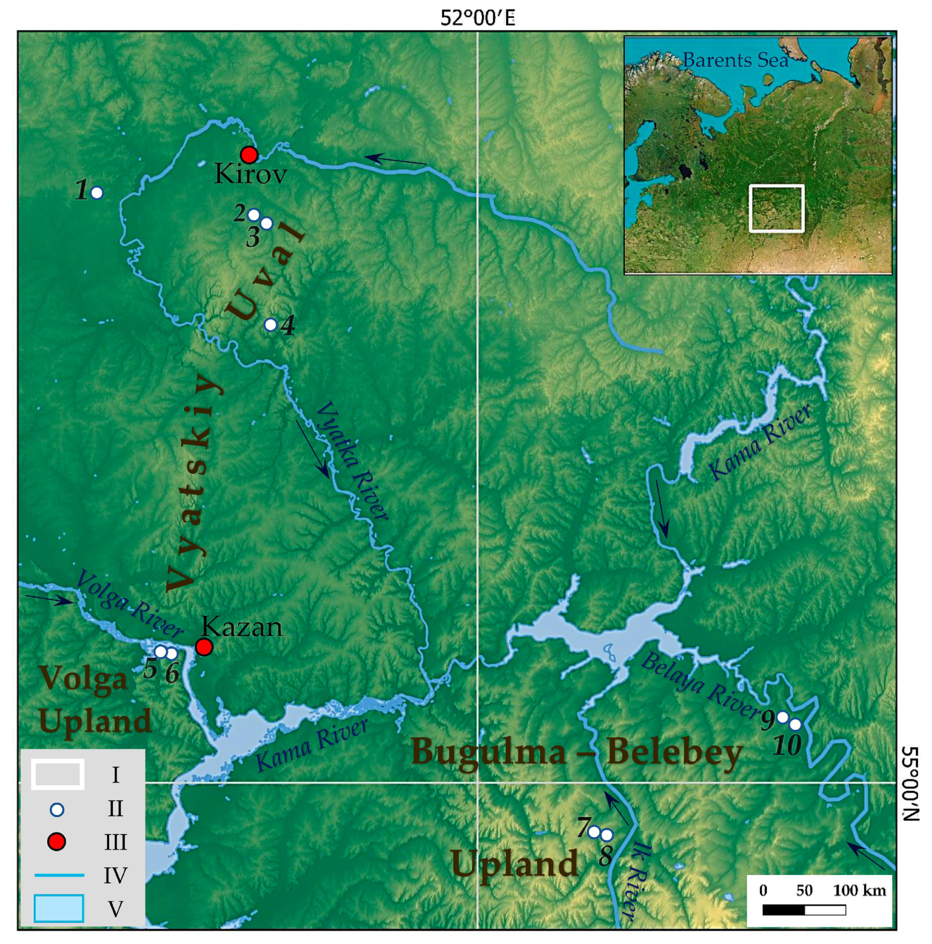
2.1. Study Rivers
2.2. Methods
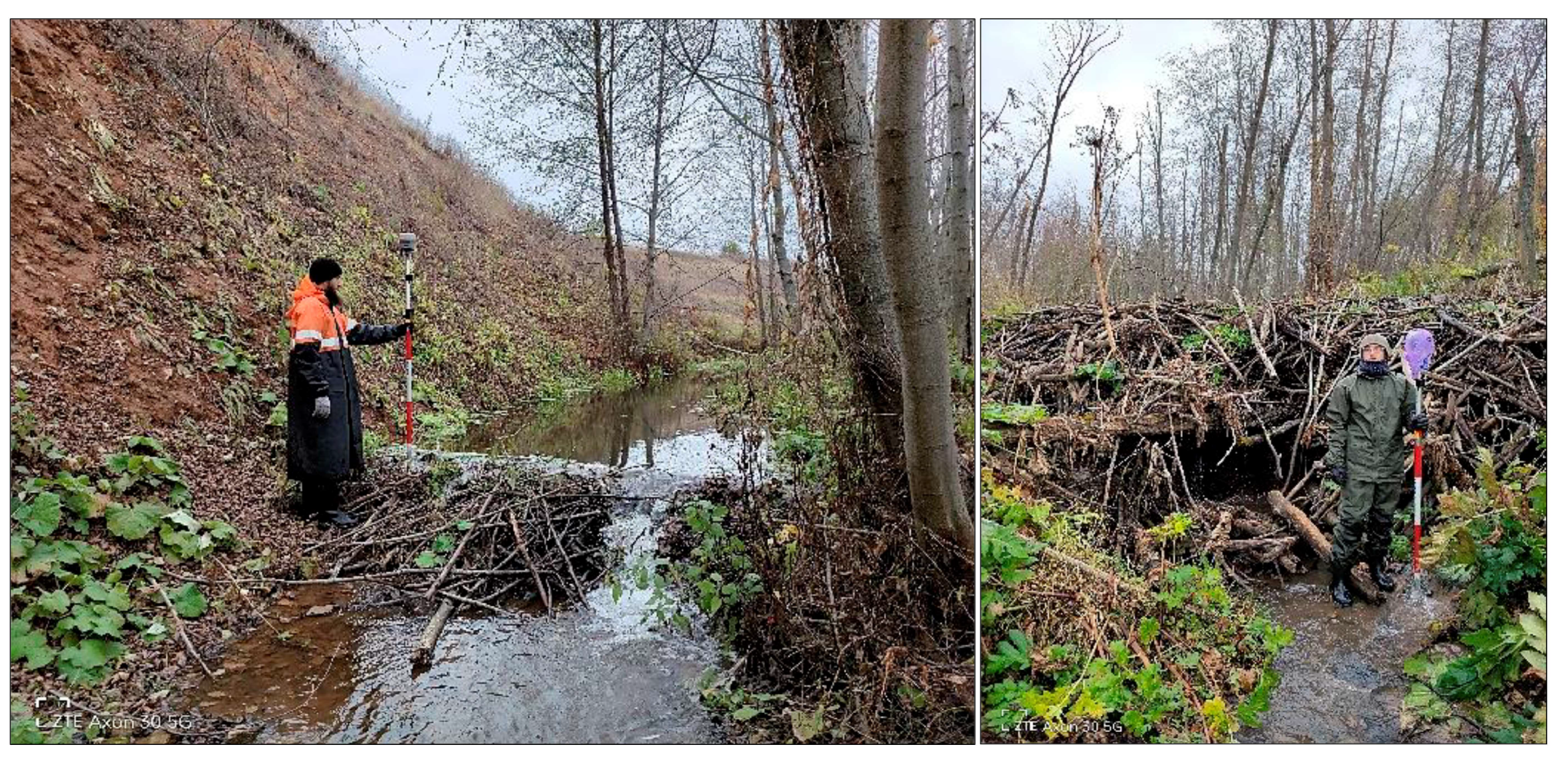
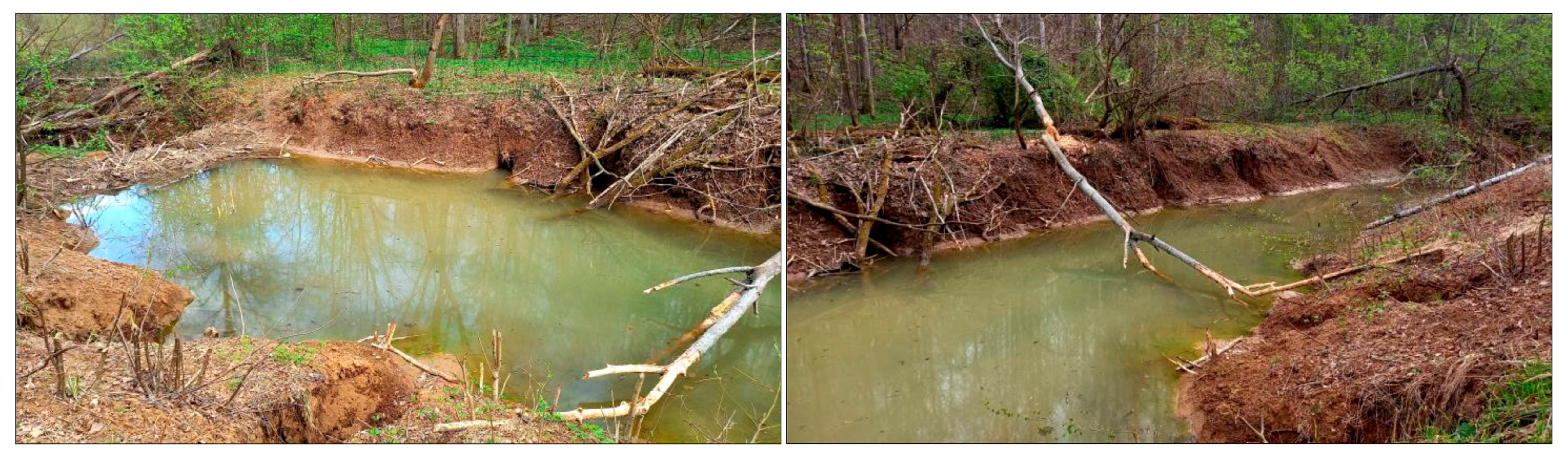
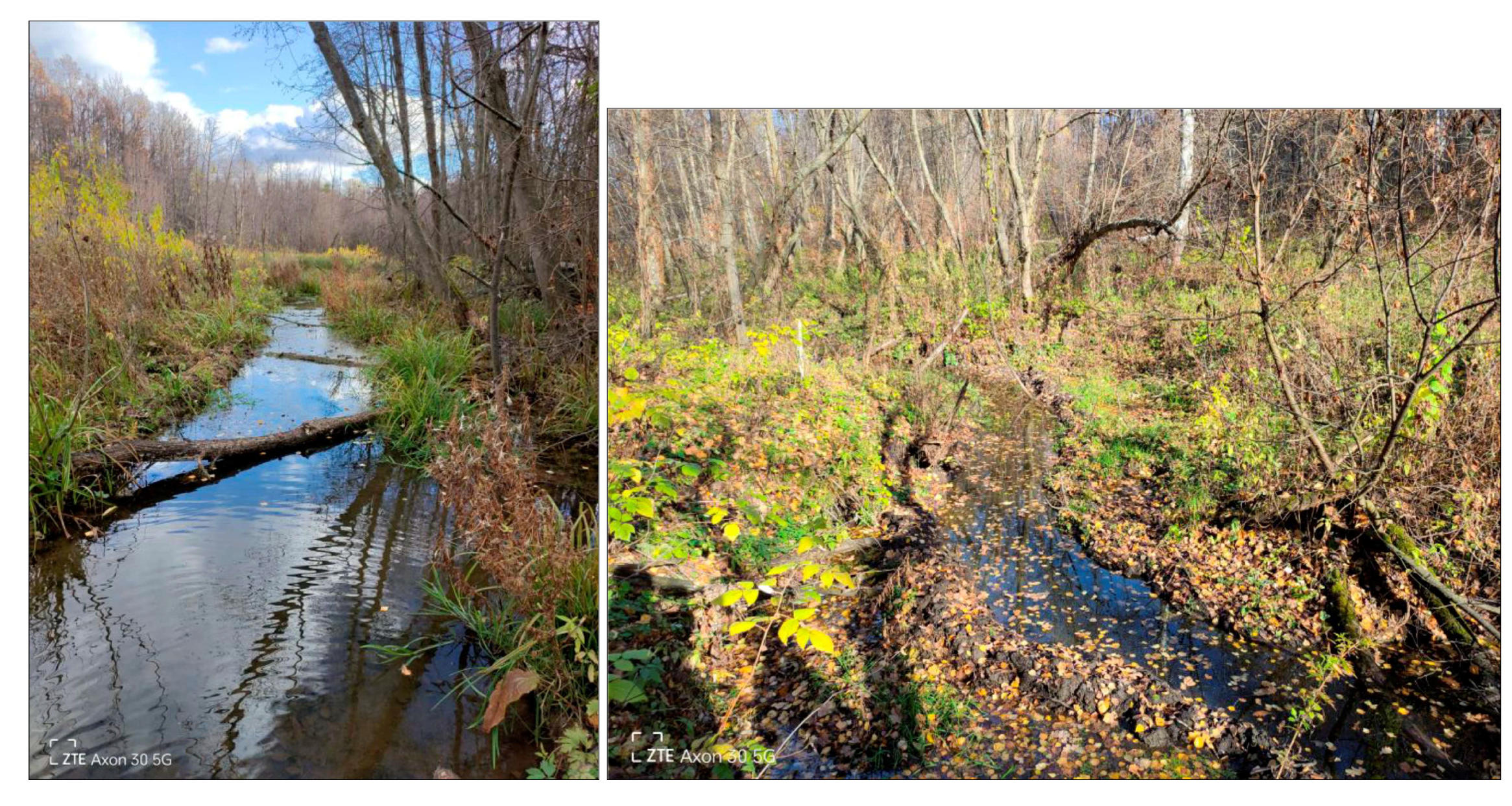
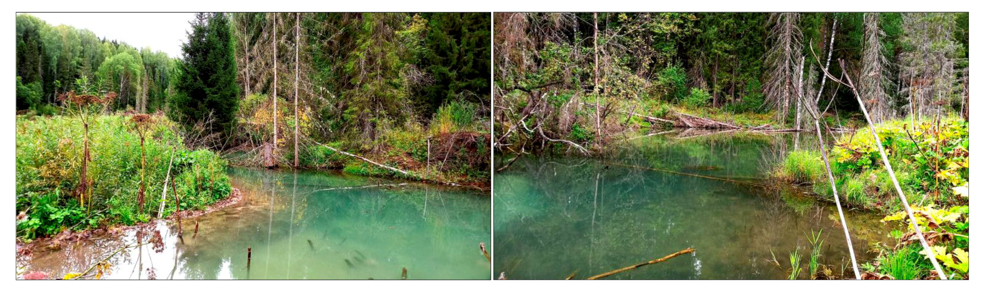
2.2.1. Field Work
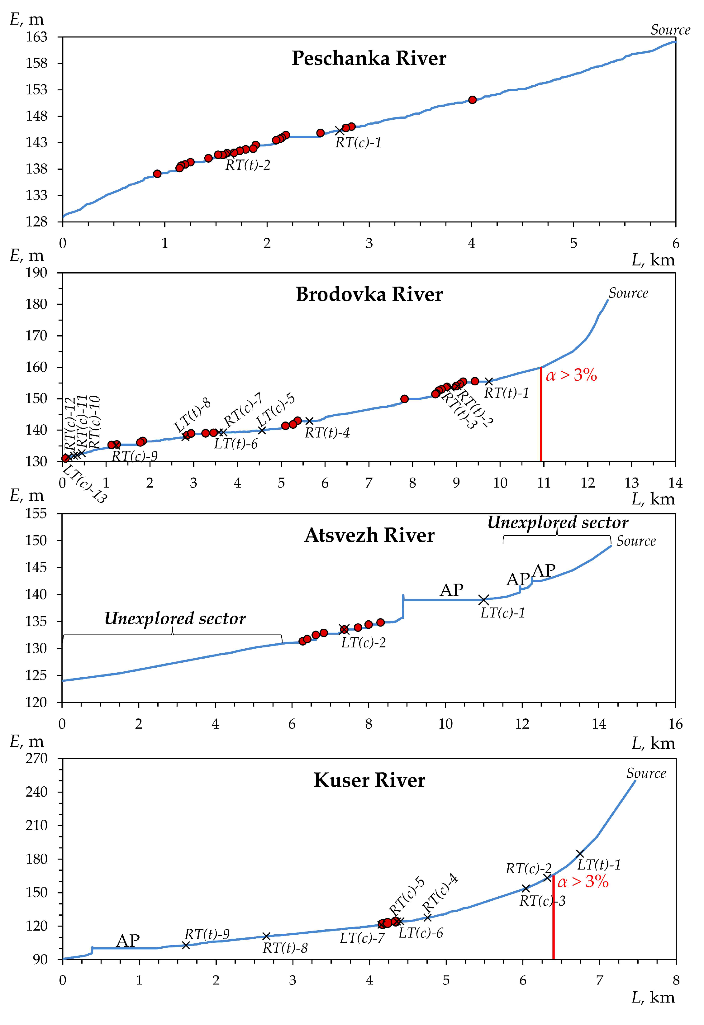
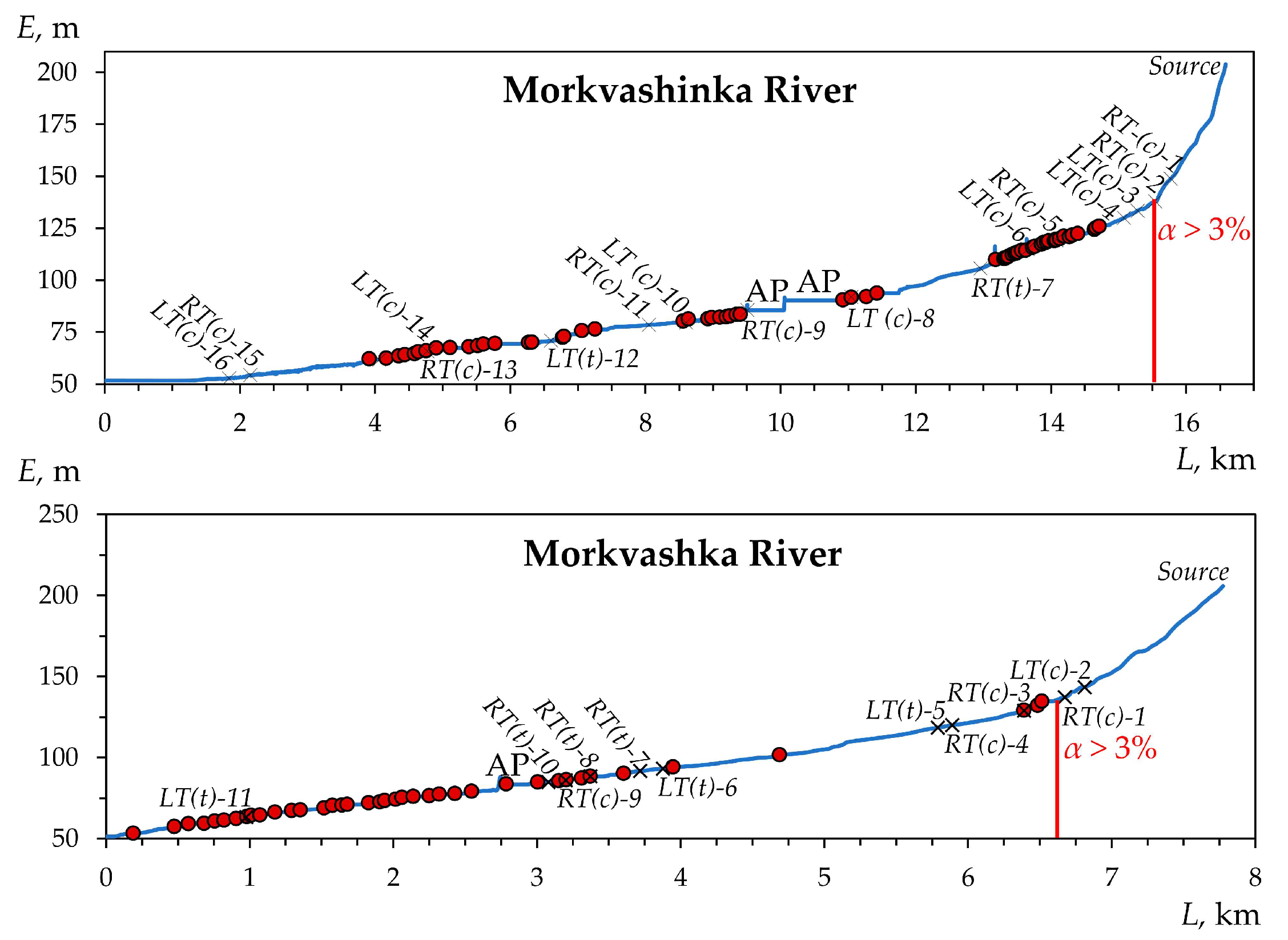
2.2.2. Field Data Processing
2.2.3. Statistics
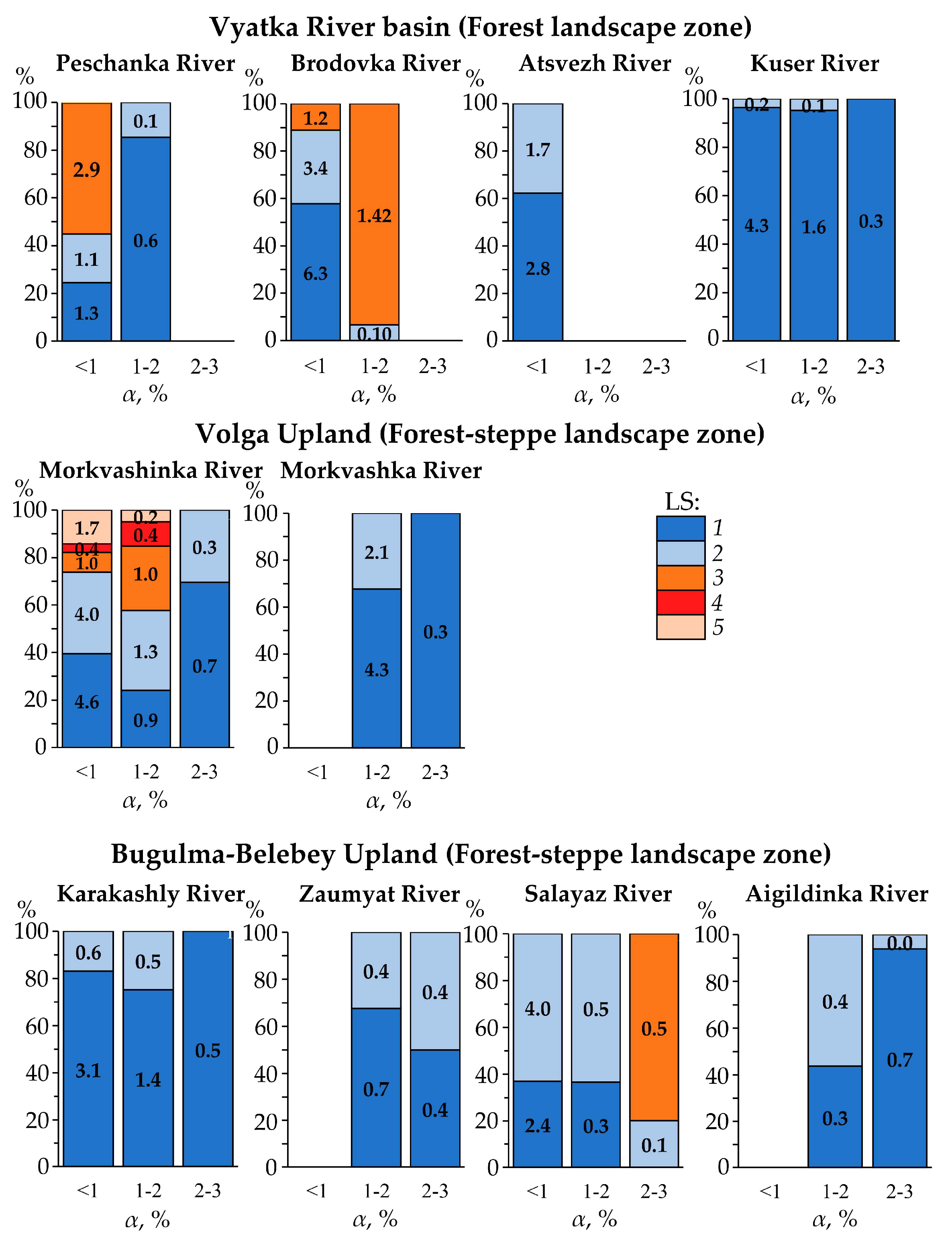
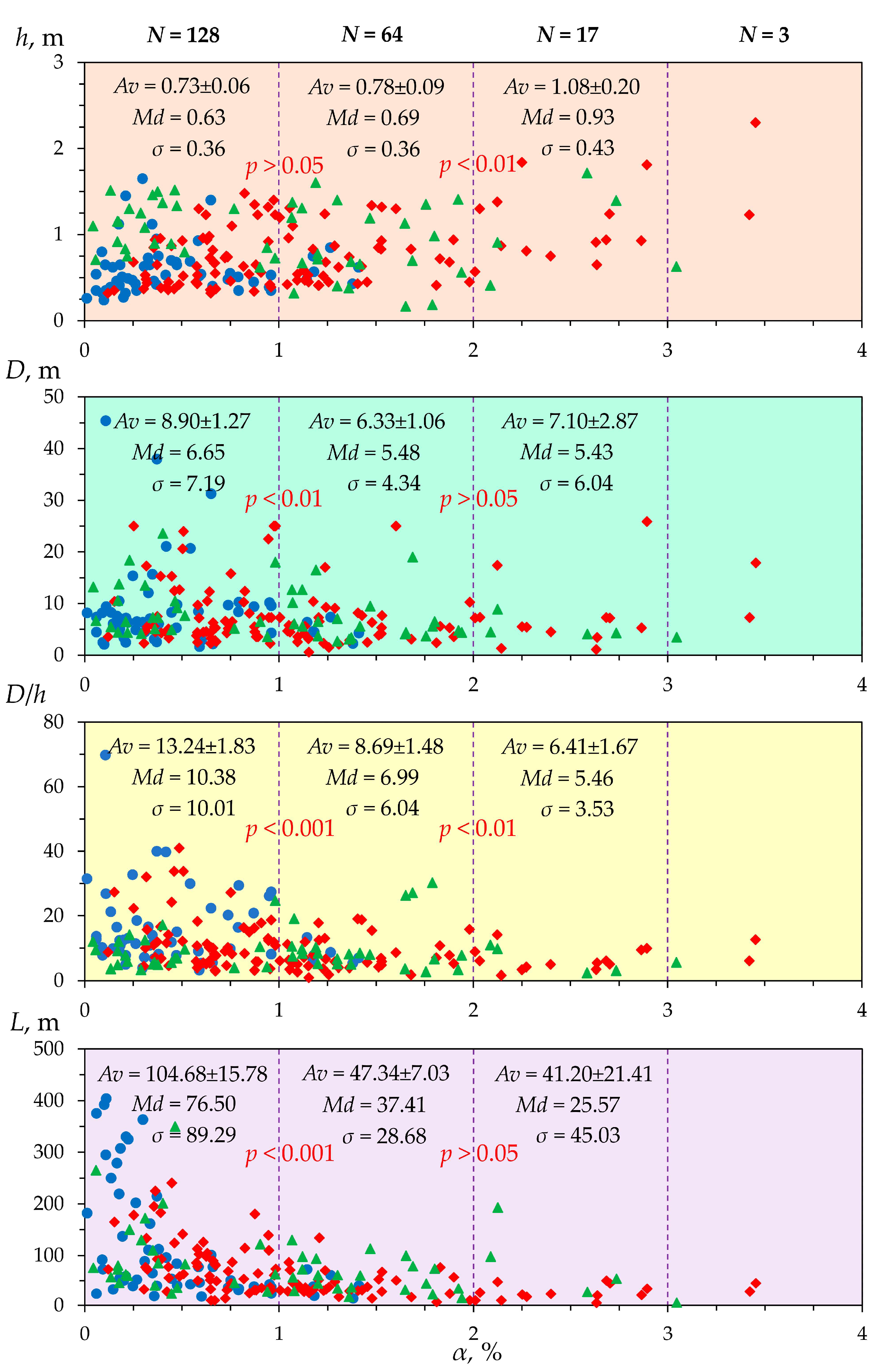
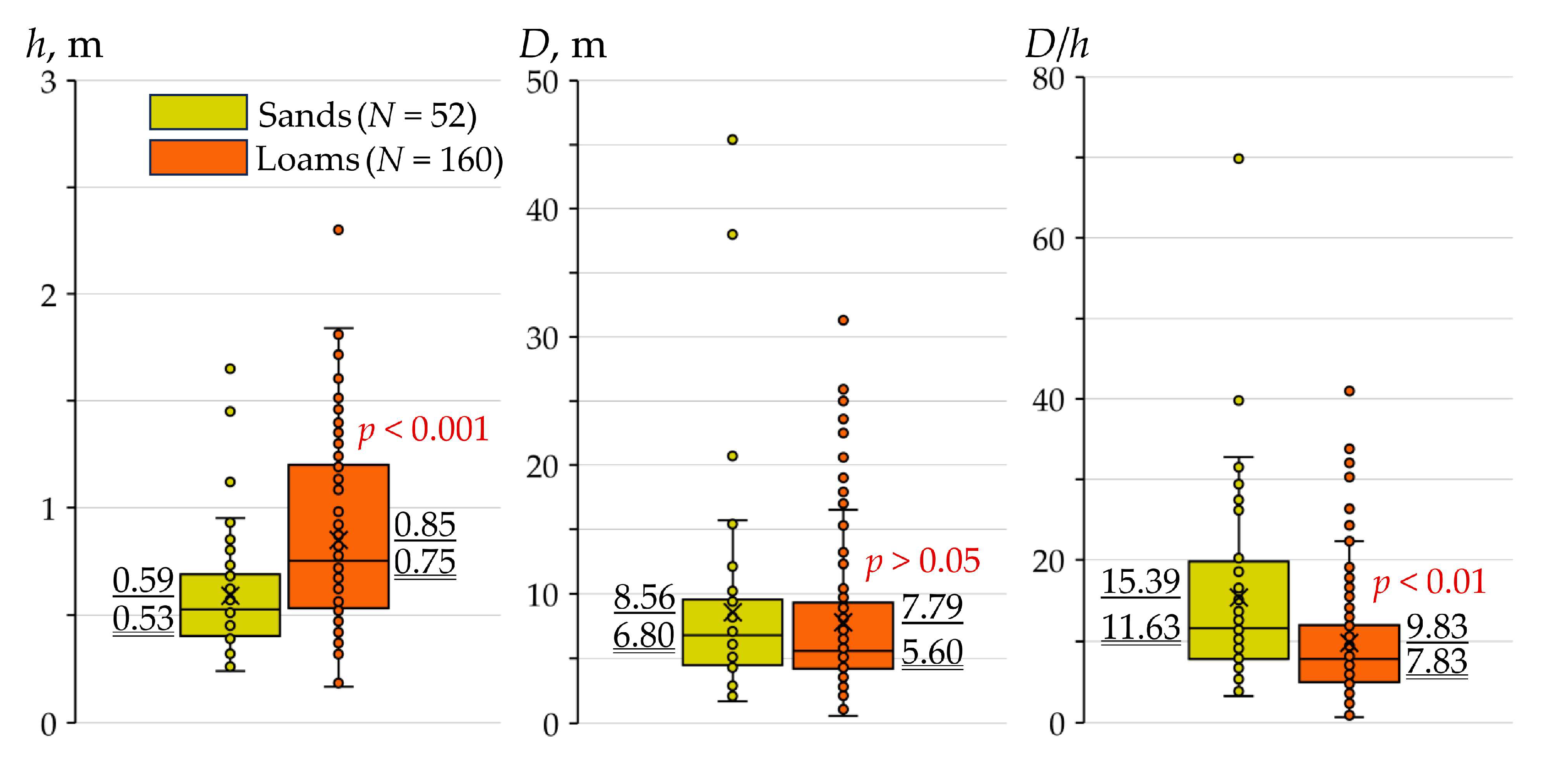
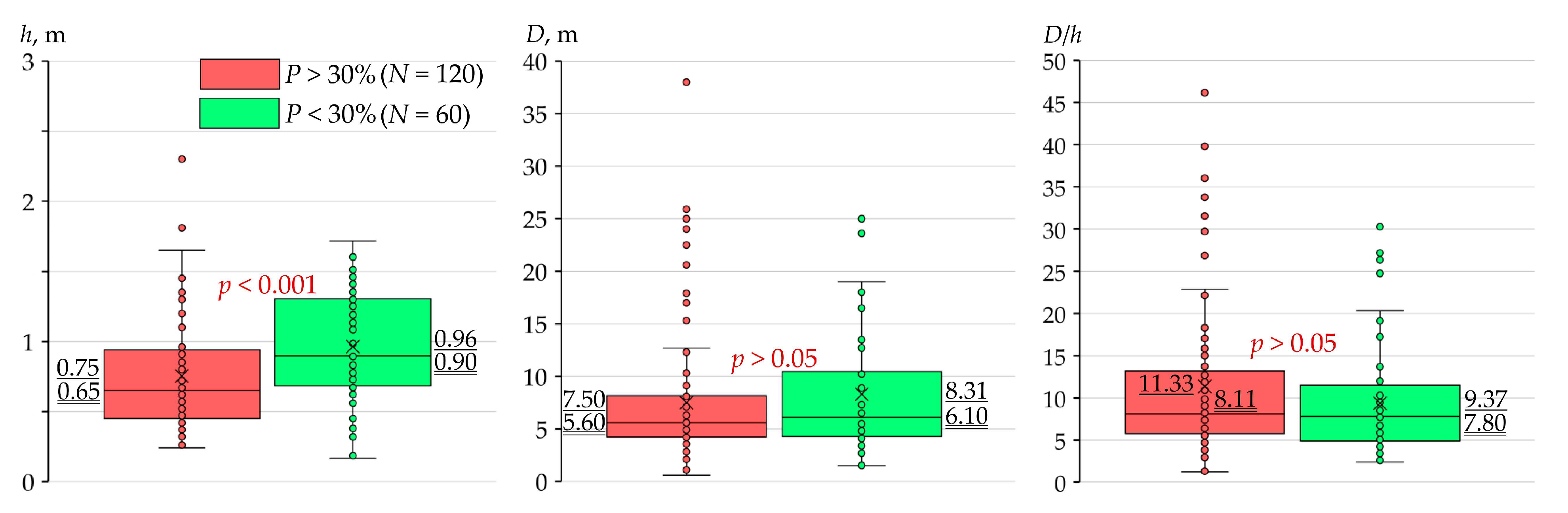
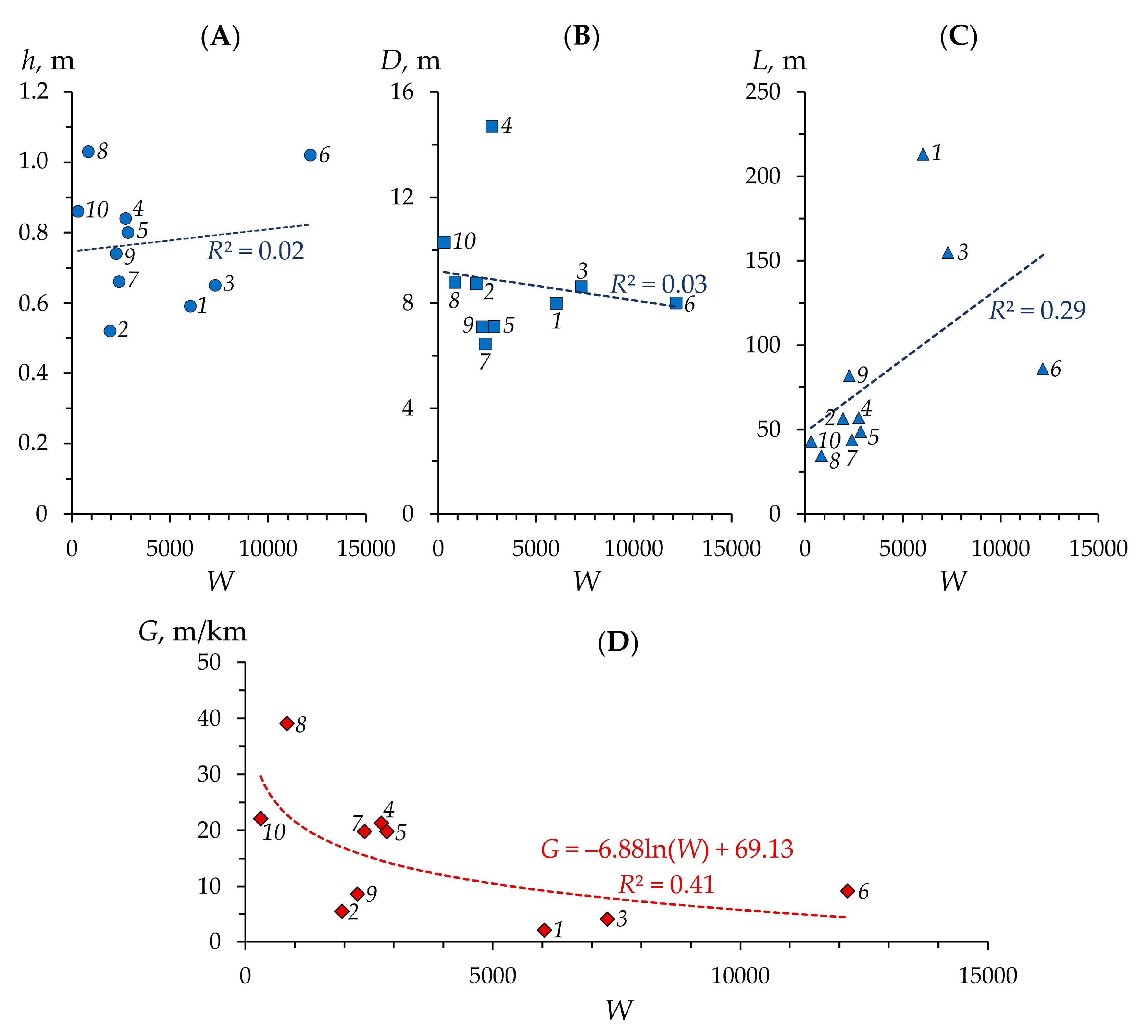
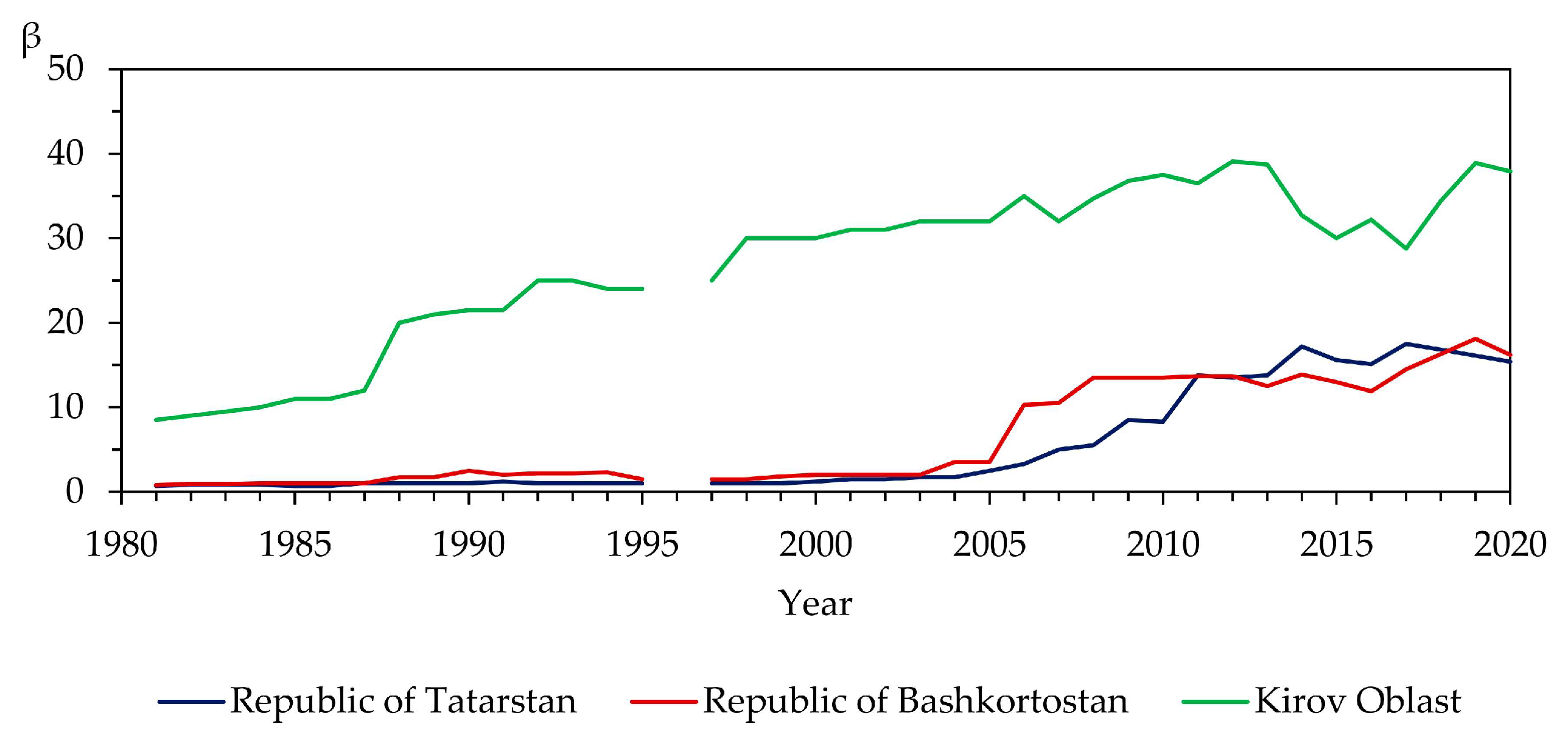
3. Results
4. Discussion
4.1. Discussion of Findings
4.2. Beaver Activity and Rivers/Channels
4.3. Study Limitations
4.4. Significance of the Results
Author Contributions
Funding
Institutional Review Board Statement
Informed Consent Statement
Data Availability Statement
Acknowledgments
Conflicts of Interest
Appendix A

| River | Geodetic Coordinate | |
|---|---|---|
| X | Y | |
| Atsvezh | 48.02137093 | 58.27730517 |
| Peschanka | 49.88532696 | 58.25902658 |
| Brodovka | 49.93813719 | 58.24867556 |
| Kuser | 49.85481140 | 57.54595759 |
| Morkvashka | 48.79267707 | 55.78247276 |
| Morkvashinka | 48.85258569 | 55.77880625 |
| Karakashly | 53.23720905 | 54.67547755 |
| Zaumyat | 53.24304844 | 54.65804955 |
| Salayaz | 55.15120169 | 55.37277285 |
| Aigildinka | 55.19192755 | 55.37082866 |

References
- Gurnell, A.M. The Hydrogeomorphological Effects of Beaver Dam-Building Activity. Prog. Phys. Geogr. 1998, 22, 167–189. [Google Scholar] [CrossRef]
- Butler, D.R.; Malanson, G.P. The Geomorphic Influences of Beaver Dams and Failures of Beaver Dams. Geomorphology 2005, 71, 48–60. [Google Scholar] [CrossRef]
- Laland, K.N.; Boogert, N.J. Niche Construction, Co-Evolution and Biodiversity. Ecol. Econ. 2010, 69, 731–736. [Google Scholar] [CrossRef]
- Westbrook, C.J.; Cooper, D.J.; Butler, D.R. Beaver Hydrology and Geomorphology.Treatise on Geomorphology; Shroder, J.F., Ed.; Elsevier: Amsterdam, The Netherlands, 2013; Volume 12, pp. 293–306. [Google Scholar]
- Jones, C.G.; Lawton, J.H.; Shachak, M. Organisms as Ecosystem Engineers. Oikos 1994, 69, 373. [Google Scholar] [CrossRef]
- Wright, J.P.; Jones, C.G.; Flecker, A.S. An Ecosystem Engineer, the Beaver, Increases Species Richness at the Landscape Scale. Oecologia 2002, 132, 96–101. [Google Scholar] [CrossRef] [PubMed]
- Coz, D.M.; Young, J.C. Conflicts over wildlife conservation: Learning from the reintroduction of beavers in Scotland. People Nat. 2020, 2, 406–419. [Google Scholar] [CrossRef]
- Pollock, M.M.; Beechie, T.J.; Wheaton, J.M.; Jordan, C.E.; Bouwes, N.; Weber, N.; Volk, C. Using Beaver Dams to Restore Incised Stream Ecosystems. Bioscience 2014, 64, 279–290. [Google Scholar] [CrossRef]
- Polvi, L.E.; Wohl, E. Biotic Drivers of Stream Planform: Implications for Understanding the Past and Restoring the Future. Bioscience 2013, 63, 439–452. [Google Scholar] [CrossRef]
- Rosell, F.; Bozser, O.; Collen, P.; Parker, H. Ecological impact of beavers (Castor fiber and Castor canadensis) and their ability to modify ecosystems. Mamm. Rev. 2005, 35, 248–276. [Google Scholar] [CrossRef]
- Law, A.; Gaywood, M.J.; Jones, K.C.; Ramsay, P.; Willby, N.J. Using ecosystem engineers as tools in habitat restoration and rewilding: Beaver and wetlands. Sci. Total Environ. 2017, 605, 1021–1030. [Google Scholar] [CrossRef]
- Willby, N.J.; Law, A.; Levanoni, O.; Foster, G.; Ecke, F. Rewilding wetlands: Beaver as agents of within-habitat heterogeneity and the responses of contrasting biota. Philos. Trans. R. Soc. B Biol. Sci. 2018, 373, 20170444. [Google Scholar] [CrossRef]
- Bylak, A.; Kukuła, K. Impact of Fine-Grained Sediment on Mountain Stream Macroinvertebrate Communities: Forestry Activities and Beaver-Induced Sediment Management. Sci. Total Environ. 2022, 832, 155079. [Google Scholar] [CrossRef] [PubMed]
- State Report on the State and Protection of the Environment of the Russian Federation. The Ministry of Natural Resources and Environment of the Russian Federation. Available online: https://www.mnr.gov.ru/docs/gosudarstvennye_doklady/gosudarstvennyy_doklad_o_sostoyanii_i_ob_okhrane_okruzhayushchey_sredy_rossiyskoy_federatsii_v_2022_/?ysclid=lq409eixqr763011706 (accessed on 23 December 2023).
- McCullough, M.C.; Harper, J.L.; Eisenhauer, D.E.; Dosskey, M.G. Channel Aggradation by Beaver Dams on a Small Agricultural Stream in Eastern Nebraska. In Proceedings of the Self-Sustaining Solutions for Streams, Wetlands, and Watersheds, St. Paul, MN, USA, 12–15 September 2004; p. 63. [Google Scholar]
- Pollock, M.M.; Beechie, T.J.; Jordan, C.E. Geomorphic Changes Upstream of Beaver Dams in Bridge Creek, an Incised Stream Channel in the Interior Columbia River Basin, Eastern Oregon. Earth Surf. Process. Landf. 2007, 32, 1174–1185. [Google Scholar] [CrossRef]
- Westbrook, C.J.; Cooper, D.J.; Baker, B.W. Beaver Assisted River Valley Formation. River Res. Appl. 2011, 27, 247–256. [Google Scholar] [CrossRef]
- Malison, R.L.; Kuzishchin, K.V.; Stanford, J.A. Do beaver dams reduce habitat connectivity and salmon productivity in expansive river floodplains? PeerJ 2016, 4, e2403. [Google Scholar] [CrossRef]
- Meentemeyer, R.K.; Vogler, J.B.; Hill, C.; Butler, D.R. The Geomorphic Influences of Burrowing Beavers on Streambanks, Bolin Creek, North Carolina. Z. Geomorphol. 1998, 42, 453–468. [Google Scholar] [CrossRef]
- Rodríguez, P.; González Garraza, G.; Garcia, V.; Granitto, M.; Escobar, J. Beaver dam effect on phytoplankton and periphyton composition and hydrology in streams from Tierra Del Fuego (Argentina). Hydrobiologia 2020, 847, 1461–1477. [Google Scholar] [CrossRef]
- Butler, D.R. The Failure of Beaver Dams and Resulting Outburst Flooding: A Geomorphic Hazard of the Southeastern Piedmont. Geogr. Bull. 1989, 31, 29–38. [Google Scholar]
- John, S.; Klein, A. Hydrogeomorphic Effects of Beaver Dams on Floodplain Morphology: Avulsion Processes and Sediment Fluxes in Upland Valley Floors (Spessart, Germany). Quaternaire 2004, 15, 219–231. [Google Scholar] [CrossRef]
- Strzelec, M.; Białek, K.; Spyra, A. Activity of Beavers as an Ecological Factor That Affects the Benthos of Small Rivers-a Case Study in the Żylica River (Poland). Biologia 2018, 73, 577–588. [Google Scholar] [CrossRef]
- Spyra, A.; Cieplok, A.; Krodkiewska, M. Beavers Ecosystem Altering: Influence of Beaver Dams on Aquatic Invertebrates in Newly Created Beavers Ponds and Small Mountain River. Ecohydrol. Hydrobiol. 2023, in press. [Google Scholar] [CrossRef]
- Law, A.; McLean, F.; Willby, N.J. Habitat Engineering by Beaver Benefits Aquatic Biodiversity and Ecosystem Processes in Agricultural Streams. Freshw. Biol. 2016, 61, 486–499. [Google Scholar] [CrossRef]
- Virbickas, T.; Stakėnas, S.; Steponėnas, A. Impact of Beaver Dams on Abundance and Distribution of Anadromous Salmonids in Two Lowland Streams in Lithuania. PLoS ONE 2015, 10, e0123107. [Google Scholar] [CrossRef] [PubMed]
- De Visscher, M.; Nyssen, J.; Pontzeele, J.; Billi, P.; Frankl, A. Spatio-Temporal Sedimentation Patterns in Beaver Ponds along the Chevral River, Ardennes, Belgium. Hydrol. Process. 2014, 28, 1602–1615. [Google Scholar] [CrossRef]
- Sinitsyn, M.G.; Rusanov, A.V. European Beaver Impact on Small Rivers Valley and Channel Relief in the Vetluga-Unzha Woodlands. Geomorfologiya 1990, 1, 85–91. (In Russian) [Google Scholar]
- Sinitsyn, M.G.; Rusanov, A.V. Effect of River Beaver on Phytocenosises and Soils of the Small River Valleys of Vetluzhsko-Unzhenskoe Woodland. Byull. Mosk. O-Va Ispyt. Prir. Otd. Biol. 1989, 94, 30–40. (In Russian) [Google Scholar]
- Katsman, E.A.; Suzdaleva, A.L.; Osipov, V.V.; Bashinskiy, I.V. Concentrations of Biogenic Compounds in Forest-Steppe Water Bodies and Streams Inhabited by Beavers (Castor fiber L.). Russ. J. Biol. Invasions 2020, 11, 31–40. [Google Scholar] [CrossRef]
- Gorshkov, D. Is It Possible to Use Beaver Building Activity to Reduce Lake Sedimentation? Lutra 2003, 46, 189–196. [Google Scholar]
- Allen, A.W. Habitat Suitability Index Models: Beaver; Fish and Wildlife Service: Washington, DC, USA, 1983. [Google Scholar]
- St-Pierre, M.L.; Labbé, J.; Darveau, M.; Imbeau, L.; Mazerolle, M.J. Factors Affecting Abundance of Beaver Dams in Forested Landscapes. Wetlands 2017, 37, 941–949. [Google Scholar] [CrossRef]
- Curtis, P.D.; Jensen, P.G. Habitat Features Affecting Beaver Occupancy along Roadsides in New York State. J. Wildl. Manag. 2004, 68, 278–287. [Google Scholar] [CrossRef]
- Jenkins, S.H. A Size-Distance Relation in Food Selection by Beavers. Ecology 1980, 61, 740–746. [Google Scholar] [CrossRef]
- Nazarov, N.G.; Prokhorov, V.E.; Sharifullin, A.G.; Gusarov, A.V.; Lisetskii, F.N. The Influence of Eurasian Beaver (Castor fiber L.) Activity on the Transformation and Functioning of Riparian Phytocoenoses in the Southern Boreal Zone (European Russia). Earth 2023, 4, 384–397. [Google Scholar] [CrossRef]
- Jensen, P.G.; Curtis, P.D.; Lehnert, M.E.; Hamelin, D.L. Habitat and Structural Factors Influencing Beaver Interference with Highway Culverts. Wildl. Soc. Bull. 2001, 29, 654–664. [Google Scholar]
- Flynn, N.J. Spatial Associations of Beaver Ponds and Culverts in Boreal Head Water Streams. Master’s Thesis, Department of Renewable Resources, University of Alberta, Edmonton, AB, Canada, 2006; p. 108. [Google Scholar]
- Jakes, A.F.; Snodgrass, J.W.; Burger, J. Castor canadensis (Beaver) Impoundment Associated with Geomorphology of Southeastern Streams. Southeast. Nat. 2007, 6, 271–282. [Google Scholar] [CrossRef]
- Halley, D.; Rosell, F.; Saveljev, A. Population and Distribution of Eurasian Beaver (Castor fiber). Balt. For. 2012, 18, 168–175. [Google Scholar]
- Goldfarb, B. Eager: The Surprising, Secret Life of Beavers and Why They Matter; Chelsea Green Publishing: London, UK, 2018. [Google Scholar]
- Boon, S. Nature’s Riverkeepers. Science 2018, 361, 338. [Google Scholar] [CrossRef]
- Miranda, A.; Hoyos-Santillan, J.; Lara, A.; Mentler, R.; Huertas-Herrera, A.; Toro-Manríquez, M.D.R.; Sepulveda-Jauregui, A. Equivalent Impacts of Logging and Beaver Activities on Aboveground Carbon Stock Loss in the Southernmost Forest on Earth. Sci. Rep. 2023, 13, 18350. [Google Scholar] [CrossRef]
- Halley, D.J.; Saveljev, A.P.; Rosell, F. Population and Distribution of Beavers Castor fiber and Castor canadensis in Eurasia. Mamm. Rev. 2021, 51, 1–24. [Google Scholar] [CrossRef]
- Naiman, R.J.; Rogers, K.H. Large Animals and System-Level Characteristics in River Corridors. Bioscience 1997, 47, 521–529. [Google Scholar] [CrossRef]
- Lavrov, D.D. (Ed.) Atlas of the Kirov Oblast; Roscartography: Moscow, Russia, 1997. [Google Scholar]
- Ermolaev, O.P.; Igonin, M.E.; Bubnov, A.Y.; Pavlova, S.V. Landscapes of the Republic of Tatarstan. Regional Landscape-Ecological Analysis; Slovo: Kazan, Russian, 2007; 411p. (In Russian) [Google Scholar]
- Graham, H.A.; Puttock, A.; Chant, J.; Elliott, M.; Campbell-Palmer, R.; Anderson, K.; Brazier, R.E. Monitoring, Modelling and Managing Beaver (Castor fiber) Populations in the River Otter Catchment, Great Britain. Ecol. Solut. Evid. 2022, 3, e12168. [Google Scholar] [CrossRef]
- Bradbury, G.; Puttock, A.; Coxon, G.; Clarke, S.; Brazier, R.E. Testing a Novel Sonar-Based Approach for Measuring Water Depth and Monitoring Sediment Storage in Beaver Ponds. River Res. Appl. 2023, 39, 266–273. [Google Scholar] [CrossRef]
- Alkan, R.; Ilçi, V.; Ozulu, I.M.; Saka, M.H. A Comparative Study for Accuracy Assessment of PPP Technique Using GPS and GLONASS in Urban Areas. Measurement 2015, 69, 1–8. [Google Scholar] [CrossRef]
- Sharifullin, A.G.; Gusarov, A.V.; Lavrova, O.A.; Beylich, A.A. Channel Gradient as a Factor in the Distribution of Beaver Dams and Ponds on Small Rivers: A Case Study in the Northern Extremity of the Volga Upland, the East European Plain. Water 2023, 15, 2491. [Google Scholar] [CrossRef]
- Topomapper. Topographic Map. Available online: http://www.atlogis.de (accessed on 23 December 2023).
- Russian Geological Research Institute. Available online: https://webmapget.vsegei.ru/?ysclid=lq57uwqvj7713899222 (accessed on 23 December 2023).
- Zavyalov, N.A. Beavers (Castor fiber and Castor canadensis), the Founders of Habitats and Phytophages. Biol. Bull. Rev. 2014, 4, 157–180. [Google Scholar] [CrossRef]
- Dedkov, A.P.; Mozzherin, V.I. Erosion and Suspended Sediment on the Earth; Kazan University: Kazan, Russia, 1984. (In Russian) [Google Scholar]
- Golosov, V.N. Erosion and Deposition Processes in River Basins of Cultivated Plains; GEOS: Moscow, Russia, 2006. (In Russian) [Google Scholar]
- Chalov, R.S. Drivers and Conditions of River Channel Character and Chande. In Fluvial Processes: Theory and Applications; Springer Nature: Cham, Switzerland, 2021; 569p. [Google Scholar]
- Stout, T.L.; Majerova, M.; Neilson, B.T. Impacts of Beaver Dams on Channel Hydraulics and Substrate Characteristics in a Mountain Stream. Ecohydrology 2017, 10, e1767. [Google Scholar] [CrossRef]
- Gibson, P.P.; Olden, J.D. Ecology, Management, and Conservation Implications of North American Beaver (Castor canadensis) in Dryland Streams. Aquat. Conserv. 2014, 24, 391–409. [Google Scholar] [CrossRef]
- Larsen, A.; Larsen, J.R.; Lane, S.N. Dam Builders and Their Works: Beaver Influences on the Structure and Function of River Corridor Hydrology, Geomorphology, Biogeochemistry and Ecosystems. Earth Sci. Rev. 2021, 218, 103623. [Google Scholar] [CrossRef]
- Brazier, R.E.; Puttock, A.; Graham, H.A.; Auster, R.E.; Davies, K.H.; Brown, C.M.L. Beaver: Nature’s Ecosystem Engineers. Wiley Interdiscip. Rev. Water 2021, 8, e1494. [Google Scholar] [CrossRef]
- Lamsodis, R.; Ulevičius, A. Geomorphological Effects of Beaver Activities in Lowland Drainage Ditches. Z. Geomorphol. 2012, 56, 435–458. [Google Scholar] [CrossRef]
- Harvey, G.L.; Henshaw, A.J.; Brasington, J.; England, J. Burrowing Invasive Species: An Unquantified Erosion Risk at the Aquatic-Terrestrial Interface. Rev. Geophys. 2019, 57, 1018–1036. [Google Scholar] [CrossRef]
- Hartman, G.; Törnlöv, S. Influence of Watercourse Depth and Width on Dam-Building Behaviour by Eurasian Beaver (Castor fiber). J. Zool. 2006, 268, 127–131. [Google Scholar] [CrossRef]
- Naiman, R.J.; Melillo, J.M.; Hobbie, J.E. Ecosystem Alteration of Boreal Forest Streams by Beaver (Castor canadensis). Ecology 1986, 67, 1254–1269. [Google Scholar] [CrossRef]
- Beier, P.; Barrett, R.H. Beaver Habitat Use and Impact in Truckee River Basin, California. J. Wildl. Manag. 1987, 51, 794–799. [Google Scholar] [CrossRef]
- Thompson, I.D. Habitat Needs of Furbearers in Relation to Logging in Boreal Ontario. For. Chron. 1988, 64, 251–261. [Google Scholar] [CrossRef]
- Butler, D.R.; Malanson, G.P. Beaver Landforms. Can. Geogr. 1994, 38, 76–79. [Google Scholar] [CrossRef]
- Butler, D.R.; Malanson, G.P. Sedimentation Rates and Patterns in Beaver Ponds in a Mountain Environment. Geomorphology 1995, 13, 255–269. [Google Scholar] [CrossRef]
- John, S.; Klein, A. Beaver Pond Development and Its Hydrogeomorphic and Sedimentary Impact on the Jossa Floodplain in Germany. Lutra 2003, 46, 183–188. [Google Scholar]
- Katsman, E.A. Floristic Diversity of Watercourses and Temporary Reservoirs of the Ostrovtsovsky Cluster of the Volga Regional Forest-Steppe State Natural Biospheric Reserve Impacted by the European Beaver’s Expansion. Povolžskij Èkologičeskij Žurnal 2018, 4, 513–518. [Google Scholar] [CrossRef]
- Perevedentsev, Y.; Gusarov, A.; Mirsaeva, N.; Sherstyukov, B.; Shantalinsky, K.; Guryanov, V.; Aukhadeev, T. Contemporary Climate Change and Its Hydrological Consequence in the Volga Federal District, European Russia. Climate 2022, 10, 198. [Google Scholar] [CrossRef]
- Perevedentsev, Y.P.; Shantalinsky, K.M.; Gusarov, A.V.; Mirsaeva, N.A.; Aukhadeev, T.R.; Nikolaev, A.A. Air Temperature Change at the End of the Late Holocene and in the Anthropocene in the Middle Volga Region, European Russia. Quaternary 2023, 6, 48. [Google Scholar] [CrossRef]
- Gusarov, A.V. The response of water flow, suspended sediment yield and erosion intensity to contemporary long-term changes in climate and land use/cover in river basins of the Middle Volga Region, European Russia. Sci. Total Environ. 2020, 719, 134770. [Google Scholar] [CrossRef] [PubMed]
- Gusarov, A.V. Land-Use/-Cover Changes and Their Effect on Soil Erosion and River Suspended Sediment Load in Different Landscape Zones of European Russia during 1970–2017. Water 2021, 13, 1631. [Google Scholar] [CrossRef]
- Martin, S.L.; Jasinski, B.L.; Kendall, A.D.; Dahl, T.A.; Hyndman, D.W. Quantifying Beaver Dam Dynamics and Sediment Retention Using Aerial Imagery, Habitat Characteristics, and Economic Drivers. Landsc. Ecol. 2015, 30, 1129–1144. [Google Scholar] [CrossRef]
- Mccomb, W.C.; Sedell, J.R.; Buchholz, T.D. Dam-Site Selection by Beavers in an Eastern Oregon Basin. Great Basin Nat. 1990, 50, 273–281. [Google Scholar]
- Macfarlane, W.W.; Wheaton, J.M.; Bouwes, N.; Jensen, M.L.; Gilbert, J.T.; Hough-Snee, N.; Shivik, J.A. Modeling the Capacity of Riverscapes to Support Beaver Dams. Geomorphology 2017, 277, 72–99. [Google Scholar] [CrossRef]
- Persico, L.; Meyer, G. Natural and Historical Variability in Fluvial Processes, Beaver Activity, and Climate in the Greater Yellowstone Ecosystem. Earth Surf. Process. Landf. 2013, 38, 728–750. [Google Scholar] [CrossRef]
- Krueger, K.A.; Johnson, B.G. The Effect of Sub-Alpine Landslides on Headwater Stream Gradient and Beaver Habitat. Phys. Geogr. 2016, 37, 344–360. [Google Scholar] [CrossRef]
- State Committee of the Republic of Tatarstan for Biological Resources in 2011–2020. Available online: https://ojm.tatarstan.ru/gosohotreestr.htm?page=1 (accessed on 27 March 2024). (In Russian).
- State Report on the State of Natural Resources and Environment of the Republic of Bashkortostan in 2011–2020. Available online: https://ecology.bashkortostan.ru/presscenter/lectures/ (accessed on 27 March 2024). (In Russian).
- Regional Reports on the State of the Environment of the Kirov Oblast in 2011–2020. Available online: https://kirovreg.ru/econom/ecology/doklad.php (accessed on 27 March 2024). (In Russian).
- Fund of Hunting Grounds and the Number of Main Species of Wild Animals in the RSFSR. Reference Materials; Novikova, B.V., Ed.; Central Scientific Research Laboratory of the Main Directorate of Hunting and Reserves under the Council of Ministers of the Rrussian Federation: Moscow, Russia, 1992. (In Russian) [Google Scholar]
- Lomanov, I.K.; Borisov, B.P.; Volodina, O.A.; Gubar, Y.P.; Lomanova, N.P.; Mirutenko, V.S.; Molochayev, A.V.; Mosheva, T.S.; Naumova, A.A.; Novikov, G.B.; et al. Resources of the Main Species of Game Animals and Hunting Grounds of Russia (1991–1995); Reference Materials; Lomanov, I.K., Ed.; Central Scientific Research Laboratory of the Hunting Department of the Ministry of Agriculture and Food of Russia: Moscow, Russia, 1996. (In Russian) [Google Scholar]
- Lomanov, I.K. (Ed.) State of Game Animal Resources in the Russian Federation. Information and Analytical Materials. In Game Animals of Russia (Biology, Protection, Study of Resources, and Rational Use); Tsentrokhotkontrol: Moscow, Russia, 2000. (In Russian) [Google Scholar]
- Lomanov, I.K. (Ed.) State of Game Animal Resources in the Russian Federation in 2000–2003. Information and Analytical Materials. In Game Animals of Russia (Biology, Protection, Study of Resources, and Rational Use); Tsentrokhotkontrol: Moscow, Russia, 2004. (In Russian) [Google Scholar]
- Gubar, Y.P. (Ed.) State of Game Animal Resources in the Russian Federation in 2003–2007. Information and Analytical Materials. In Game Animals of Russia (Biology, Protection, Study of Resources, and Rational Use); Tsentrokhotkontrol: Moscow, Russia, 2007. (In Russian) [Google Scholar]
- Lomanov, I.K. (Ed.) State of Game Animal Resources in the Russian Federation in 2008–2010. Information and Analytical Materials. In Game Animals of Russia (Biology, Protection, Study of Resources, and Rational Use); Tsentrokhotkontrol: Moscow, Russia, 2011. (In Russian) [Google Scholar]


| Parameter | Study River | |||||||||
|---|---|---|---|---|---|---|---|---|---|---|
| Forest Landscape Zone | Forest-Steppe Landscape Zone | |||||||||
| Atsvezh | Peschanka | Brodovka | Kuser | Morkvashka | Morkvashinka | Karakashly | Zaumyat | Salayaz | Aigildinka | |
| Ntot | 8 | 22 | 22 | 3 | 40 | 61 | 24 | 18 | 56 | 9 |
| L, km | 5.1 1 | 6.1 | 12.5 | 7.5 | 7.8 | 16.6 | 6.9 | 4.3 | 7.7 | 2.7 |
| S, km2 | 29.9 | 9.2 | 34.5 | 13.2 | 20.4 | 86.9 | 19.7 | 6.9 | 22.6 | 3.1 |
| Ě, m | 151 | 168 | 164 | 182 | 165 | 152 | 239 | 252 | 161 | 175 |
| A, m | 9.8 | 33.6 | 50.7 | 159.3 | 154.4 | 152.1 | 136.6 | 167.9 | 66.0 | 59.3 |
| G, m/km | 2.1 | 5.5 | 4.1 | 21.3 | 19.8 | 9.2 | 19.8 | 39.1 | 8.6 | 22.1 |
| T, °C | 3.1 | 2.9 | 2.9 | 3.3 | 4.4 | 4.4 | 3.9 | 3.9 | 3.6 | 3.6 |
| Ť, °C | 3.1 | 4.0 | ||||||||
| P, mm/y | 630 | 623 | 629 | 591 | 546 | 546 | 531 | 531 | 494 | 494 |
| Pav, mm/y | 618 | 524 | ||||||||
| R, mm/y | 202 | 212 | 212 | 208 | 140 | 140 | 122 | 122 | 100 | 100 |
| Ř, mm/y | 209 | 121 | ||||||||
| Lith | Sd, Cl, Lm | Sd | Lm, BS, Sd | Sd, Lm, BS | Lm, Lim | Lm, Lim | Lm, Lim | Lm, Lim | Lm, Sd, Lim | Lm, Sd, Lim |
| Soil | Umbric Albeluvisols | Greyic Phaeozems | Voronic Chernozems | |||||||
| Vegetation | TF | BLF | MS | |||||||
| Ant, % | 19 | 3 | 31 | 0 | 3 | 20 | 43 | 32 | 42 | 22 |
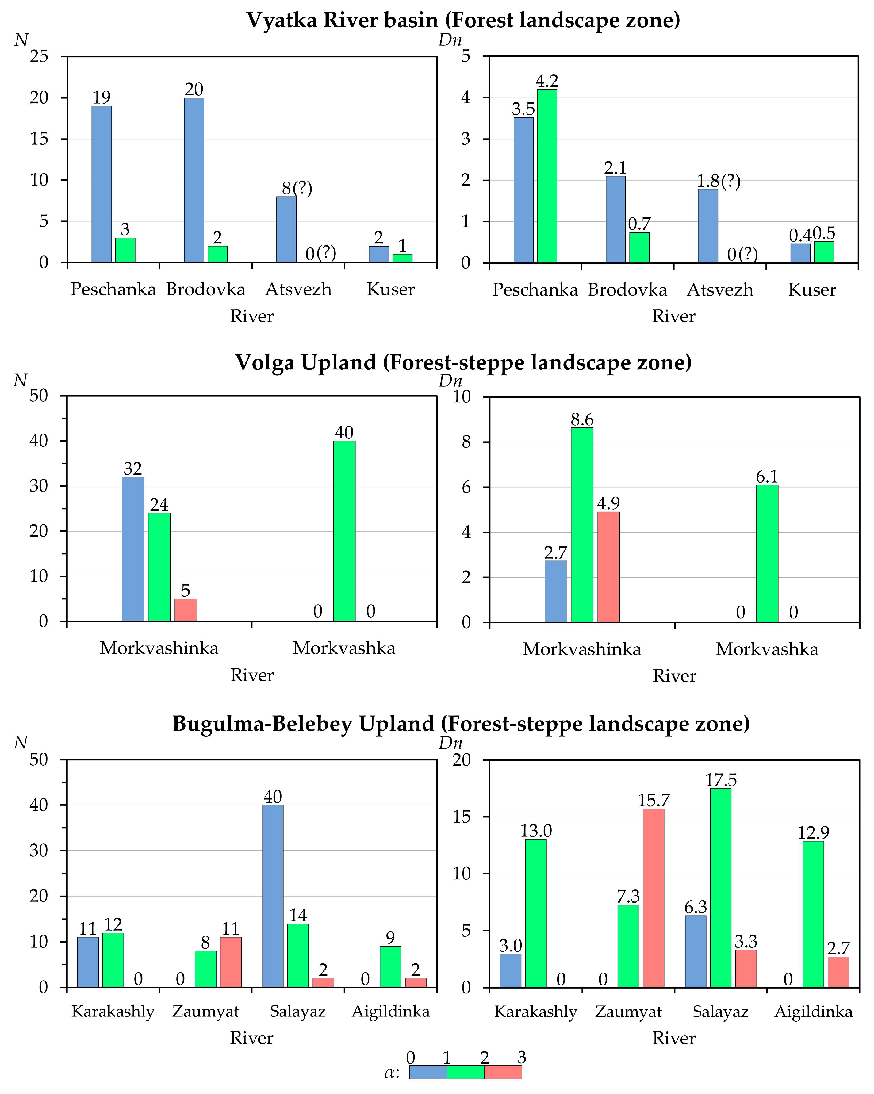
| Averaged Parameter (See Table 1 and Figure 10) | Subregion and River | |||
|---|---|---|---|---|
| Vyatka River Basin | Volga Upland | Bugulma-Belebey Upland | ||
| Atsvez, Peschanka, Brodovka, Kuser | Morkvashinka, Morkvashka | Karakashly, Zaumyat, | Salayaz, Aigildinka | |
| Ě, m | 166.3 | 158.5 | 245.5 | 168.0 |
| G, m/km | 8.3/4.0 1 | 14.5 | 29.5 | 15.4 |
| R, mm/y | 209 | 140 | 122 | 100 |
| N | 47 (of 55) | 23 (of 50) | 14 (of 42) | 44 (of 65) |
| h, m | 0.60 ± 0.08 | 1.09 ± 0.12 | 0.61 ± 0.19 | 0.74 ± 0.09 |
| (p < 0.001) | — | (p < 0.001) | (p < 0.001) | |
| D, m | 9.38 ± 2.42 | 9.13 ± 2.18 | 7.83 ± 2.02 | 8.45 ± 2.09 |
| — | (p > 0.05) | (p > 0.05) | (p > 0.05) | |
| D/h | 16.28 ± 3.39 | 8.69 ± 2.09 | 15.22 ± 4.82 | 12.05 ± 2.92 |
| — | (p < 0.001) | (p > 0.05) | (p > 0.05) | |
| L, m | 128.1 ± 32.9 | 102.4 ± 41.9 | 46.2 ± 18.8 | 93.4 ± 15.8 |
| — | (p > 0.05) | (p < 0.001) | (p > 0.05) | |
Disclaimer/Publisher’s Note: The statements, opinions and data contained in all publications are solely those of the individual author(s) and contributor(s) and not of MDPI and/or the editor(s). MDPI and/or the editor(s) disclaim responsibility for any injury to people or property resulting from any ideas, methods, instructions or products referred to in the content. |
© 2024 by the authors. Licensee MDPI, Basel, Switzerland. This article is an open access article distributed under the terms and conditions of the Creative Commons Attribution (CC BY) license (https://creativecommons.org/licenses/by/4.0/).
Share and Cite
Gusarov, A.V.; Sharifullin, A.G.; Beylich, A.A.; Lisetskii, F.N. Features of the Distribution of Beaver Dams and Ponds along Small Rivers: The Volga-Kama Region, European Russia. Hydrology 2024, 11, 53. https://0-doi-org.brum.beds.ac.uk/10.3390/hydrology11040053
Gusarov AV, Sharifullin AG, Beylich AA, Lisetskii FN. Features of the Distribution of Beaver Dams and Ponds along Small Rivers: The Volga-Kama Region, European Russia. Hydrology. 2024; 11(4):53. https://0-doi-org.brum.beds.ac.uk/10.3390/hydrology11040053
Chicago/Turabian StyleGusarov, Artyom V., Aidar G. Sharifullin, Achim A. Beylich, and Fedor N. Lisetskii. 2024. "Features of the Distribution of Beaver Dams and Ponds along Small Rivers: The Volga-Kama Region, European Russia" Hydrology 11, no. 4: 53. https://0-doi-org.brum.beds.ac.uk/10.3390/hydrology11040053