Investigation Strategy for Structural Assessment of Historic Towers †


Politecnico di Milano, Department ABC—Architecture, Built Environment and Construction Engineering, 20133 Milan, Italy
*
Author to whom correspondence should be addressed.
†
Paper Selected from the REHABEND 2020 Congress. Extended version for publishing in the Journal.
Infrastructures 2020, 5(12), 106; https://0-doi-org.brum.beds.ac.uk/10.3390/infrastructures5120106
Submission received: 30 October 2020
/
Revised: 20 November 2020
/
Accepted: 23 November 2020
/
Published: 1 December 2020
(This article belongs to the Special Issue Selected Papers from the REHABEND 2020 Congress)
Abstract
:Historical masonry towers are relevant architectural heritage often in a strategic position within city centres. Their height and position require specific controls in order to define the state of preservation. The paper describes the investigation procedures developed by the authors in selected case studies. According to the timing and to the complexity of the structure, the approach requires preliminary visual inspections, geometric, crack pattern survey supplemented by historical research and stratigraphic survey. Operational modal testing evaluates the overall structural behaviour, indicating eventual local (or global) problems to study in depth by monitoring or further local tests. Emergency operations, such as controls after earthquakes, could require prompt procedures. In this case, the combination of visual inspection, geometric and damage survey with dynamic testing is a reliable procedure for structural assessment. Additional investigation increases the knowledge of local problems or gives information for further activity such as structural modelling. For instance, relevant data are the evaluation of the masonry quality or the control of the local state of stress to estimate through non-destructive or minor destructive testing in selected positions. Nevertheless, such activities require accurate projects of the investigation too, planning and localising several tests in order to solve the problems detected in the preliminary steps of the diagnosis process.
1. Introduction
Thinking about the country and urban skyline, towers often represent distinguishable but harmonized diffused entities in landscapes with deep historic and symbolic significances; they embody the distinctive characteristics of the construction methods of the past, mainly related to masonry. The towers—defensive, religious or civic ones—are at the same time architectonic heritage and frequently challenging structures of their time. In most case, these structures were the top of the engineering and architectural technology of their time and region, showing the builders’ deep empirical knowledge concerning the materials locally available and of the construction solutions.
Despite the frequent high quality of the past buildings, the literature documents several heavy damages during earthquakes (Figure 1) or even collapses without an evident direct action [1,2,3,4]; the analysis of such case-studies shows some common problems, including the frequent absence of a continue use and/or of controls.
Due to the height, the structural survey of the towers is a complex task, requiring a direct inspection of the wall surface. Furthermore, extended and detailed experimental investigations are difficult to propose due to the large number of towers, particularly in historic centres.
The authors have developed and addressed procedures to study historic towers with different levels of complexity and aimed at defining a baseline for the future monitoring of the structure.
The combination of direct survey of the geometry, of the materials and of the visible damage, the collection of historic information and the dynamic testing define an effective minimal procedure to analyse the structural behaviour of historic towers. Dynamic monitoring complements the strategy, allowing the early warning of any structural change with a full agreement between the safety requirements and the conservation principles.
The paper describes the procedures through some case studies recently investigated by the authors. Furthermore, the manuscript focuses on the advantages of each investigation and experimental steps, stressing the type and the importance of each collected piece of information as well as the following data merging and results comparison.
2. The Diagnosis Project
A reliable conservation strategy of the architectural heritage involves the collection of information about the building characteristics, building technology and state of preservation. The processing of such information leads to conservation projects and re-use programs having, as priority, the safety of the structure, the compatibility with the structure characteristic and actual re-use possibility, as well as respect of the pre-existence and of the historical, cultural, documentary values according to the Restoration Principles and Recommendations for the Analysis and Restoration of Architectural Heritage (ICOMOS/ISCARSAH, 2005) [5]. Within this approach, the diagnosis and the monitoring of the structures are key factors. The most advanced international procedures concerning the structural assessment of the architectural heritage define this item as a complex and multidisciplinary activity [6,7]; it requires the collection of information from several disciplines, despite the lack of addressed and clear merging procedures.
The diagnosis process is usually aimed at defining the state of preservation of a building. The activity, that has to be always accurately designed [6,7], could start from detected or supposed damage (e.g., presence of relevant cracks or controls after an earthquake) or planned within a general control program. Specific investigation could support interventions, both in the selection of the technique, during the application or following the works to evaluate their effectiveness.
In general, the preliminary approach is an overall visual inspection oriented to plan and organize the future actions to carry out step-by-step. In fact, the problems or the parameters to explore could not be clear before the first onsite activity but progressively resulting from the inspections or from the tests.
Three main steps distinguish the following knowledge process; the first one concerns the survey of the geometry, the crack pattern and the masonry stratigraphy (changes in the surface materials and textures), supported by documentary research. According to the procedure calibrated by the authors, the further steps concern the control of the structure’s general behaviour by dynamic testing, eventually supplemented by monitoring, and the eventual investigation of the materials or of local problems.
2.1. Visual Inspections, Geometric Survey and Crack Pattern Survey
Visual inspection is probably the first step approaching the diagnosis of an existing building, intertwined with geometric and crack pattern survey. The operation aims at collecting information about the characteristic of the building recognizable to the naked eye. Observation concerning the building technology and materials, masonry textures, and surface discontinuities are important structural data often poorly documented. Furthermore, the systematization of the collected data effects a reliable diagnostic process. Stratigraphic operation fulfils the requirement of the direct survey of the building and of the data organization. In fact, the stratigraphy survey of a masonry elevation is a method to map and to reconstruct the sequence of the building steps (constructive and destructive actions) recognizable on the wall surface through the changes in the masonry texture (Figure 2 and Figure 3). The method comes from archaeological digging [8] and from geology; afterwards, it was systematically calibrated to architecture application, identifying the transformation of un-plastered masonry fronts [9]. The interpretation of the elevation stratigraphy involves the identification of homogeneous masonry portions (stratigraphic units—SU) and the consequent analysis of the physical relationships with the surrounding area. Until the 19th century the interventions were carried out with similar materials; infilled openings, local dismantling and rebuilding and repairs. Additions could be recognizable only by the changes in the masonry texture, eventual variation of the blocks (size, colour or surface finishing) or the mortars (colour, grain size, joint thickness, etc.). The observation of the boundary contour of each homogeneous masonry portion reconstructs the layering of the actions on the masonry that is the process in times of addition, demolition and modification. This analysis process, synthetized by the Harris diagram and matrix (developed by EC Harris in 1974 [8]), can only give relative dates that are not absolute; nevertheless, it produces a robust framework to eventually supplement by absolute dates, if available, obtained by other research.
Each stratigraphic unit is accurately surveyed and catalogued, collecting detailed information about the masonry texture, the masonry components, the eventual surface tooling and workmanship [9], as well as the relationship with the adjacent units.
The localisation of the masonry discontinuities allows for recognising eventual weakness of the structural layout, which could trigger local and global damage (Figure 3b). Owing to the lack of effective connection, seismic actions could overturn some weakly restrained masonry portions (Figure 3).
Figure 2 and Figure 3 show an example of the possible effective coupling of survey and analysis of the possible vulnerability. The detailed survey of the masonry textures carried out on the Gabbia Tower in Mantua [10] aimed at recognising the structural discontinuities and the boundaries of the weakly restrained portions (Figure 2a,b and Figure 3a). Based on the investigation, an evaluation of the out-of-plane seismic behaviour for each recognised masonry portion not effectively linked could be carried out (Figure 3c,d). This procedure, implemented according the most recent technical literature and the Italian seismic code, gives an overview of the seismic vulnerability related to the building transformation over time and the effect of local damage.
The visual inspection is generally carried out together with the geometric survey, if not already available. A reliable geometrical survey is a powerful diagnostic tool, giving important information about the general structural layout and pointing out eventual irregularities, such as deviations from verticality or other deformation, as well as the presence of adjacent structures. In fact, detailed geometric survey aids in the detecting and the mapping of the several structural anomalies (like local masonry reconstruction, infilled openings, niches, flues, etc.), the structural damage and the stratigraphic reconstruction to consider in the diagnosis [6]. The high resolution orthopicture of the fronts is a necessary support for the drawing up of monothematic surveys, including the crack pattern survey, and to have a general view of the building and its details. Advanced survey techniques, such as photogrammetry and laser scanning are more widely used in the survey of historic structures, due to their versatility and precision; furthermore, their application can reduce the generation time of the 3D geometrical model of the building and of the passage to the structural model despite some intrinsic problems, such as the mesh compatibility or the effect of local distortions, small imprecisions and the complexity of the historic structures. Nevertheless, the technical literature documents several applications of advanced survey techniques supporting HBIM (Historic Building Information Modelling) [11,12,13] and structural modelling [14,15].
The crack pattern survey defines eventual critical situations due to defects in the structural response to static ordinary actions or to aggressive actions, even occurred in the past; in any case, its interpretation requires an accurate mapping of the discontinuities too, due to the several evolution steps, which could lead to local weakening or local stiffness changes (Figure 4 and Figure 5). Furthermore, the reconstruction of the history of the past aggressive actions on the specific building or the events that occurred on a territorial scale could help the analysis.
The cracks should be drawn on the geometrical survey of both the inner and outer elevation, in order to distinguish crack passing through the wall section. The cracks should be classified according their direction (vertical, diagonal, horizontal, curved, etc.), their dimension (extension, width, passing through the wall, non-passing through, etc.), but also if they were already repaired in the past or not. Nevertheless, the re-opening of repaired cracks could be associated with the permanence of the damage source or simply to the seasonal thermal cycles. The final risk analysis of the structure requires the monitoring of the crack opening. Nevertheless, static monitoring is a long-term activity requiring at least 18 months to evaluate the impact of the normal thermal effects.
The crack pattern survey has to be very accurate, considering even thin cracks. Creep damage produces diffused nets of very thin cracks, often not considered dangerous or simply not visible through the usual inspection from the ground floor. Creep damage could evolve slowly until the unexpected and sudden collapse of the structure, as was the case for the Civic Tower of Pavia (1989) or for the Cathedral of Noto (1996) [2,16].
The direct survey of the building is more effective with the availability of preliminary information, such as technical drawings or other graphic documents not detailed (e.g., plans, cross sections, additional works, cadastral information and maps, etc., often available in the municipality or superintendence offices). Old photographs and pictures could help check the state of the construction in time and interpret the eventual irregularities of the structure (Figure 2) or the damage evolution. The output of this investigation is a reliable identification of the local anomalies to investigate within the following activity. Furthermore, material changes, discontinuities, and concentration of cracks are important input data for the structural assessment, indicating changes of the mechanical properties of the materials.
2.2. Historical and Documentary Research
From a tradition point of view, the most unexpected parameter for the structural assessment is the historical analysis and the reconstruction of the building evolution [17]. However, changes in time modify the structural layout, weakening the connections and strength. Sharp changes in construction techniques or bad connections between walls can trigger weaknesses in the structural organization.
Detailed documents concerning the history of a single building, even a monument, are seldom available. Important buildings could have rich administrative archive; nevertheless, the damage description, if present, is often only drafted as well as the details of the repair works. Documents concerning the general accounting, the buying of building materials or the payment of architects or workers could be available, but the interventions are seldom described and localized in the building. However, the knowledge of the used materials, the general amount of work and the possible dating comprise important diagnostic information. Furthermore, if the documentation lacks, the direct survey of the building could supplement the data. For this reason, a complete picture of the aggressive events occurring on a site is important. The ancient local chronicles often described disasters and their general effects on an urban scale. Events such as earthquakes, floods, fires, storms, military attacks, etc., could produce diffuse heavy damage not directly documented for a single building. Lightening often damaged towers, spires and pinnacles.
Useful research is the comparison between the past aggressive events and the reconstruction of the building transformation. The 20th century introduced new materials, building technology and intervention concept. In repair intervention or in building additions, the traditional structural technology is progressive integrated by reinforced concrete and cement mortar. Despite the difficulty of categorising the effectiveness of an intervention, several examples of weak compatibility between old structures and new intervention or poor application/workmanship were surveyed after several earthquakes. The dating, the recognising of the building technology and the localisation of the intervention, then, assumes a critical importance.
The collection of historical drawings and pictures supplements the information concerning the building evolution. Historical drawings and paintings should be evaluated with caution, in order to exclude artistic interpretation or plans not completely carried out.
Since the 1850s, photography has documented, with reliability, the architecture. Pictures and postcards are a precious source of information about the evolution of the main buildings, sometimes detailing the eventual works as in the case of the pictures of the Italian Superintendence for Cultural Heritage or of the architects involved in the restoration, now in private archive. Due to their height, the towers are often clearly visible even in general landscape pictures.
On an urban scale, historical map comparison shows the progressive construction of adjacent buildings or the clustering of former volumes, or the contrary. Figure 5 documents the former presence of several structures now destroyed. The discontinuities of the masonry textures indicate former passages between adjacent buildings, now infilled.
3. Dynamic Testing and Monitoring
Visual inspection, geometric and crack pattern survey associated to historical research give a first general idea of the tower and its characteristic, detecting irregularities and local damage but only qualitatively. The next step of the process requires the collection of quantitative data through dynamic testing. Dynamic testing is a reliable technique to evaluate the overall behaviour of a tower through the measure of acceleration or velocity in reference acquisition points along the structure height [18,19]. Preliminary visual inspections and onsite surveys are highly recommended in order to correctly design the test and the acquisition layout.
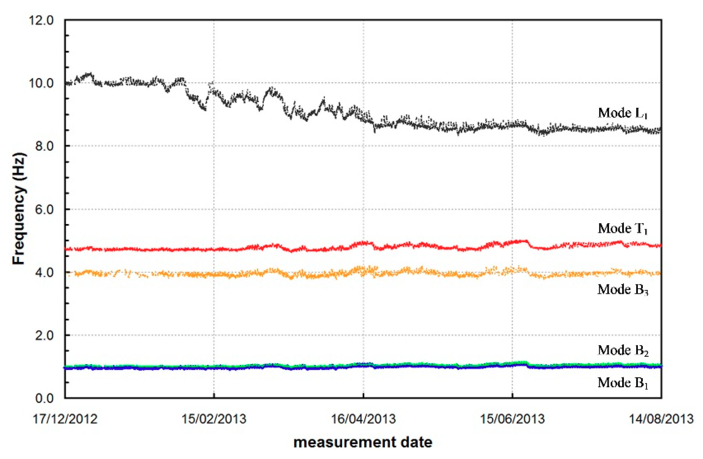
The data processing reconstructs the dynamic behaviour of the structure in terms of natural frequencies and mode shapes; the natural frequencies are parameters representative of the global behaviour of the system, while the mode shapes allow for detecting the local performance. The analysis of the mode shapes, in fact, could recognise and localise eventual damaged areas or structurally relevant irregularities (Figure 6 and Figure 7). Such information, supported by the results of visual inspections and historic research, could help in localising eventual structural problems to explore in depth, reducing the number of the on-site and laboratory tests of materials, which are in general time-consuming and cost-ineffective.
The modal parameters are very sensible to any change in the behaviour. For instance, acquisitions extended for one or more days with variable temperature, detect the thermal variation of the structural behaviour. In general, the natural frequencies increase with increased temperature [20,21]; in fact, the thermal expansion, inducing the closing of mortar gaps, of local irregularity or of surface cracks, can temporarily compact the materials, involving an increase in the natural frequencies, as well. The authors systematically detect this behaviour in several case-histories [20,21], as well as in similar research of the literature [22,23]; the deviations from this typical behaviour could highlight structural problems.
The first dynamic tests were time consuming, requiring forced vibration with massive devices (local hammering systems or vibrodines); the evolution of the theoretic data-processing framework progressively leads toward the present estimation using operational (or output-only) modal analysis techniques and the acquisition of the vibration induced by the ambient excitation (micro-tremors, wind, traffic, etc.). The method becomes an easy and sustainable non-destructive way of testing, carried out by acquiring the structural response under ambient excitation; the testing activity does not interfere with the normal building use.
No touch systems could acquire vibration data in order to test the structural behaviour in prompt investigations, such as thorough investigations in a territory or in emergency conditions (e.g., post-earthquake controls) [24,25]. The authors had the opportunity within a joint research between IDS and Politecnico di Milano (VibLab, Laboratory of Vibrations and Dynamic Monitoring of Structures), mainly aimed to validate the results of the microwave interferometer, named IBIS-S (Image By Interferometric Survey of Structures) and to assess the equipment performances in ambient vibration testing of full-scale bridges and other structures [26,27]. The sensor prototype was originally developed by the Italian company IDS (Ingegneria Dei Sistemi, Pisa, Italy), in collaboration with the University of Florence, within the framework of a research project funded by the Italian Government [28]. The sensor combines the use of radar interferometry and high-resolution waveforms to simultaneously measure the deflection of several points on a large structure with high accuracy. The technology is based on two main ideas: (a) to employ high resolution electromagnetic wave-forms to take consecutive images of the investigated structure, with each image being a distance map of the intensity of radar echoes coming from the reflecting targets (e.g., each discontinuity of a structure or corner zones); (b) to evaluate the displacement of each target detected in these images from the phase of the back-scattered electromagnetic waves collected at different times (microwave interferometry) [28].
Despite some sensibility problems of microwave remote sensing [21,24], the techniques might be extensively applied for identifying the dynamic characteristics of masonry towers (Figure 8) when: (1) only the fundamental vibration modes are needed (as it happens in wide programmes of preventive conservation or in post-earthquake assessment); (2) special issues have to be investigated (such as the effects of bell swinging). In those cases, the application microwave remote sensing is very quick and accurate and does not expose the test crew to hazardous conditions. On the contrary, if the identification of the upper vibration modes in several pre-selected points is needed, the use of conventional high-sensitivity accelerometers is still preferred.
The availability of experimental data concerning the structural behaviour is very helpful for the calibration of structural models, as well [19,29,30,31].
Dynamic Monitoring
Dynamic testing could detect problems to investigate more in detail or to control in time. Once known, the global behaviour of a structure, even simple monitoring systems, could detect eventual changes. The acquisition system could be composed by: (a) one four-channel data acquisition system; (b) three high sensibility piezoelectric accelerometers, mounted on the cross-section at the crowning level of the towers; (c) one temperature sensor, installed on the South front and measuring the outdoor temperature; (d) one industrial PC on site, for the system management and data storage. Continuous dynamic monitoring is a very attractive and reliable technique in conservation strategy detecting any possible anomaly or minimal change in the structural behaviour (Figure 9 and Figure 10) and evaluating the dynamic response of the structure to environmental factors or to eventual near or far-field earthquakes (Figure 11).
The experimental evidence is of considerable importance for the formulation of alarm protocols. In fact, once removed, the temperature effects from the natural frequencies trend and the “normal” variation intervals associated with the loading and environment vibration are defined, the limits of the identified natural frequencies constitute parameters representative of an alarm threshold for the identification of anomalies or alterations of the current structural conditions. Notwithstanding the quite complex mechanisms that define the normal response of a structure under changing temperature, multivariate regression models turned out to be appropriate to predict the natural frequency changes of the tower, given the measured environmental/operational conditions, and to address the structural health monitoring strategies [20,21,22,32].
4. Local Tests and Material Sampling
The former steps of the diagnostic program could detect local irregularities (i.e., infilled openings (Figure 12), flues, niches, etc.) or require further information, such as the masonry composition, the characteristics of the materials, the control of the local state of stress or the evaluation of the elastic behaviour (Figure 13 and Figure 14). The activity could be very complex and should be accurately designed considering the contribution of the several investigation techniques [6]. Non-destructive (NDT) or minor destructive techniques (MDT) at present mostly need specific calibration to explore a problem and the complementary use of different tests is highly recommended [6,16,33].
For instance, a reliable procedure to evaluate the masonry quality requires the carrying out of pulse sonic tests, single and double flat-jack (Figure 14) in meaningful points of the structure, selected according to the diagnostic project [6]. Laboratory tests on sampled materials in the same position supplement the information. Direct visual inspections by local dismantling by removing a few bricks or stones and surveying photographically and drawing the section, conclude the evaluation of the masonry composition. The execution of small local dismantling is preferable to coring for the evaluation of the masonry quality in selected points. Generally, coring extracts crumbled materials. Nevertheless, once the characteristics of the masonry are evaluated and the non-destructive techniques locally calibrated (like e.g., pulse sonic tests) by eventual small direct inspections, cores or boroscopy, the NDT could be applied to other areas of the structure, in order to extend the experimental evidence. The laboratory characterization of the materials supplements the evaluation of the masonry quality and gives parameters for the design of compatible repair materials.
In wide experimental activities, flatjacks, single and double, could be applied to estimate the distribution of the state of stress along the height of the structure compared to the masonry behaviour onset of cracking (Figure 13) [16].
Local damage could require static monitoring, measuring in time the displacement of two points across a crack by high-resolution devices. Static monitoring should be long-term, not less than 18 months, in order to rule out the influence of the seasonal temperature variation and to identify the eventual progression of damage [21,34]. The dependence of the crack opening from the temperature is well known (Figure 15): it might conceal the damage effect in the data, as any variation due to structural changes would be masked by the fluctuations caused by environmental factors. In fact, one of the limits of the crack displacement monitoring concerns the type of data, too local and requiring a long time to distinguish possible structural issues from the environmental effects.
5. Conclusions
Diagnostic investigation of historic masonry towers is a complex multidisciplinary activity, merging information from several research branches. Despite their apparently cultural distance, data from direct surveys, historic research and ambient vibration testing contribute to reliable structural assessment. Several strategies provide historical information: visual inspections and stratigraphic surveys map the main visible transformation often not datable; archive and bibliographic research could supplement the information, as well as the historical cadastral maps or the reconstruction of the Code timeline for recent intervention. Furthermore, dating the transformation helps in the identification of the building technology and materials and the potential discontinuities.
The marks of the historical transformations should be always recognized directly on the towers, highlighting the potential local vulnerability or the structural problems to monitor or to mitigate.
In general, preliminary inspections plan the future experimental activity to carried out step-by-step. Nevertheless, the research could be carried out at several levels of investigation, according to the aim of the activity and of the building problems. In fact, prompt investigation after earthquakes should be carried out in a short time with no touch acquisition systems.
On the contrary, wide investigations could involve, besides the geometrical, damage, stratigraphic survey and the ambient vibration test, the monitoring of the structure and the carrying out of local tests.
In the preservation framework, activities concerning the architectural heritage must be integrated by suitable long-term maintenance programs. The proposed diagnostic strategy fully meets such actions: it could be the starting point of the long-term program, properly supported by the continuing structural monitoring able to early detect changes in the behaviour. Due to their diffusion, characteristics and possible problems, the tower safety would require such an approach in order to prevent catastrophic events.
The research focuses on the main steps of the diagnosis of historic Towers, stressing the relevance of each action within the process of Preservation of the Architectural Heritage.
Author Contributions
The contribution of both the authors is equal. All authors have read and agreed to the published version of the manuscript.
Funding
The investigation was partially supported by the Mantua Municipality (Gabbia Tower tests) by the Municipality of Castelleone (Torre Isso tests) and by the Parish of Monza (test on the Bell-Tower of Monza Cathedral).
Acknowledgments
M. Cucchi and M. Iscandri (VibLab, Laboratory of Vibrations and Dynamic Monitoring of Structures, Politecnico di Milano), Arch. C. Tiraboschi and Arch. Cantini (Politecnico di Milano) are gratefully acknowledged for the assistance during the on-site tests and the dynamic monitoring. The authors wish to thank the Engineers P. Borlenghi, M. Guidobald and A. Ruccolo for the support during the onsite activity and data processing. The authors would like to thank IDS (Ingegneria Dei Sistemi, Pisa, Italy) for supplying the radar sensor employed in the tests.
Conflicts of Interest
The authors declare no conflict of interest.
References
- Saisi, A.; Gentile, C. Investigation Strategy for Structural Assessment of Historic Towers. In Proceedings of the 8th Euro-American Congress REHABEND, Advances in Architecture. Granada, Spain, 24–27 March 2020. [Google Scholar]
- Binda, L.; Anzani, A.; Saisi, A. Failures due to long-term behaviour of heavy structures. In Learning from Failure: Long-Term Behaviour of Heavy Masonry Structures; Advances in Architecture; Binda, L., Ed.; WIT Press: Southampton, UK, 2008; pp. 1–28. [Google Scholar]
- Cattari, S.; Degli Abbati, S.; Ferretti, D.; Lagomarsino, S.; Ottonelli, D.; Tralli, A. Damage assessment of fortresses after the 2012 Emilia earthquake (Italy). Bull. Earthq. Eng. 2014, 12, 2333–2365. [Google Scholar] [CrossRef]
- Saisi, A.; Terenzoni, S. Historic military architectures in the province of Mantua: The effects of the 2012 earthquakes. In Proceedings of the 9th International Conference on Structural Analysis of Historical Constructions SAHC 2014, Mexico City, Mexico, 14–17 October 2014; pp. 1–12. [Google Scholar]
- ICOMOS/ISCARSAH Committee. Recommendations for the analysis, Conservation and Structural Restoration of Architectural Heritage; ICOMOS International Committee for Analysis and Restoration of Structures of Architectural Heritage, 2005; Available online: www.icomos.org (accessed on 23 November 2009).
- Binda, L.; Saisi, A.; Tiraboschi, C. Investigation procedures for the diagnosis of historic masonries. Constr. Build. Mater. 2000, 14, 199–233. [Google Scholar] [CrossRef]
- Lourenço, P.B. Recommendations for restoration of ancient buildings and the survival of a masonry chimney. Constr. Build. Mater. 2006, 20, 239–251. [Google Scholar] [CrossRef] [Green Version]
- Harris, E.C. Principles of Archaeological Stratigraphy; Academic Press: London, UK, 1979; 136p. [Google Scholar]
- Doglioni, F. Stratigrafia e Restauro. Tra Conoscenza e Conservazione Dell’architettura; Lint Editoriale Associati: Trieste, Italy, 1997; 312p. (In Italian) [Google Scholar]
- Saisi, A.; Gentile, C. Post-earthquake diagnostic investigation of a historic masonry tower. J. Cult. Herit. 2015, 16, 602–609. [Google Scholar] [CrossRef]
- Bruno, S.; De Fino, M.; Fatiguso, F. Historic Building Information Modelling: Performance assessment for diagnosis-aided information modelling and management. Autom. Constr. 2018, 86, 256–276. [Google Scholar] [CrossRef]
- Banfi, F.; Barazzetti, L.; Previtali, M.; Roncoroni, F. Historic BIM: A new repository for structural health monitoring. In Proceedings of the GEOMATICS RESTORATION—Conservation of Cultural Heritage in the Digital Era, Florence, Italy, 22–24 May 2017; pp. 269–274. [Google Scholar]
- Brumana, R.; Oreni, D.; Barazzetti, L.; Cuca, B.; Previtali, M.; Banfi, F. Survey and scan to bim model for the knowledge of built heritage and the management of conservation activities. In Digital Transformation of the Design, Construction and Management Processes of the Built Environment; Daniotti, B., Gianinetto, M., Della Torre, S., Eds.; Springer: Berlin/Heidelberg, Germany, 2020; pp. 391–400. [Google Scholar]
- Barazzetti, L.; Banfi, F.; Brumana, R.; Gusmeroli, G.; Previtali, M.; Schiantarelli, G. Cloud-to-BIM-to-FEM: Structural simulation with accurate historic BIM from laser scans. Simul. Model. Pract. Theory 2015, 57, 71–87. [Google Scholar] [CrossRef]
- Korumaz, M.; Betti, M.; Conti, A.; Tucci, G.; Bartoli, G.; Bonora, V.; Korumaz, A.G.; Fiorini, L. An integrated Terrestrial Laser Scanner (TLS), Deviation Analysis (DA) and Finite Element (FE) approach for health assessment of historical structures. A minaret case study. Eng. Struct. 2017, 153, 224–238. [Google Scholar] [CrossRef]
- Binda, L.; Saisi, A.; Tiraboschi, C. El comportamiento a largo plazo de torres y estructuras de fábrica. El Campanario de la Catedral de Monza. Loggia Arquit. Restaur. 2010, 22–23, 108–121. [Google Scholar] [CrossRef] [Green Version]
- Roca, P. Considerations on the significance of history for the structural analysis of ancient constructions. In Proceedings of the Structural Analysis of Historical Constructions IV, Padova, Italy, 10–13 November 2004; pp. 63–73. [Google Scholar]
- Ivorra, S.; Pallarés, F.J. Dynamic investigations on a masonry bell tower. Eng. Struct. 2006, 28, 660–667. [Google Scholar] [CrossRef]
- Gentile, C.; Saisi, A. Ambient vibration testing of historic masonry towers for structural identification and damage assessment. Constr. Build. Mater. 2007, 21, 1311–1321. [Google Scholar] [CrossRef]
- Saisi, A.; Gentile, C.; Guidobaldi, M. Post-earthquake continuous dynamic monitoring of the Gabbia Tower in Mantua, Italy. Constr. Build. Mater. 2015, 81, 101–112. [Google Scholar] [CrossRef]
- Saisi, A.; Gentile, C.; Ruccolo, A. Pre-diagnostic prompt investigation and static monitoring of a historic bell-tower. Constr. Build. Mater. 2016, 122, 833–844. [Google Scholar] [CrossRef] [Green Version]
- Ubertini, F.; Comanducci, G.; Cavalagli, N.; Pisello, A.L.; Materazzi, A.L.; Cotana, F. Environmental effects on natural frequencies of the San Pietro bell tower in Perugia, Italy, and their removal for structural performance assessment. Mech. Syst. Signal Process. 2017, 82, 307–322. [Google Scholar] [CrossRef]
- Azzara, R.M.; De Roeck, G.; Girardi, M.; Padovani, C.; Pellegrini, D.; Reynders, E. The influence of environmental parameters on the dynamic behaviour of the San Frediano bell tower in Lucca. Eng. Struct. 2018, 156, 175–187. [Google Scholar] [CrossRef]
- Gentile, C.; Saisi, A. Radar-based vibration measurement on historic masonry towers. In Emerging Technologies in Non-Destructive Testing V; Paipetis, A.S., Ed.; Taylor Francis Group: London, UK, 2012; pp. 51–56. ISBN 978-0-415-62131-1. [Google Scholar]
- Pieraccini, M.; Dei, D.; Betti, M.; Bartoli, G.; Tucci, G.; Guardini, N. Dynamic identification of historic masonry towers through an expeditious and no-contact approach: Application to the “Torre del Mangia” in Siena (Italy). J. Cult. Herit. 2014, 15, 275–282. [Google Scholar] [CrossRef]
- Gentile, C.; Bernardini, G. An interferometric radar for non-contact measurement of deflections on civil engineering structures: Laboratory and full-scale tests. Struct. Infrastruct. Eng. 2010, 6, 521–534. [Google Scholar] [CrossRef]
- Gentile, C.; Saisi, A. Ambient vibration testing and condition assessment of the Paderno iron arch bridge (1889). Constr. Build. Mater. 2011, 25, 3709–3720. [Google Scholar] [CrossRef]
- Pieraccini, M.; Fratini, M.; Parrini, F.; Macaluso, G.; Atzeni, C. Highspeed CW step-frequency coherent radar for dynamic monitoring of civil engineering structures. Electron. Lett. 2004, 40, 907–908. [Google Scholar] [CrossRef]
- Diaferio, M.; Foti, D.; Potenza, F. Prediction of the fundamental frequencies and modal shapes of historic masonry towers by empirical equations based on experimental data. Eng. Struct. 2018, 156, 433–442. [Google Scholar] [CrossRef]
- Peña, F.; Lourenço, P.B.; Mendes, N.; Oliveira, D.V. Numerical models for the seismic assessment of an old masonry tower. Eng. Struct. 2010, 32, 1466–1478. [Google Scholar] [CrossRef] [Green Version]
- Standoli, G.; Giordano, E.; Milani, G.; Clementi, F. Model updating of historical belfries based on OMA identification techniques. Int. J. Archit. Herit. 2020, 1–25. [Google Scholar] [CrossRef]
- Ubertini, F.; Cavalagli, N.; Kita, A.; Comanducci, G. Assessment of a monumental masonry bell-tower after 2016 central Italy seismic sequence by long-term SHM. Bull. Earthq. Eng. 2018, 16, 775–801. [Google Scholar] [CrossRef]
- Binda, L.; Condoleo, P.; Saisi, A.; Tiraboschi, C.; Zanzi, L. Experimental assessment of historic building safety: The case of the Isso Tower in Castelleone, Italy. In 6th International Conference on Structural Analysis of Historical Construction SAHC; Taylor and Francis: Boca Raton, FL, USA, 2008; pp. 1331–1338. ISBN 978-0-415-46872-5. [Google Scholar]
- Roca, P.; Martínez, G.; Casarin, F.; Modena, C.; Rossi, P.P.; Rodríguez, I.; Garay, A. Monitoring of long-term damage in long-span masonry constructions. In Learning from Failure: Long-Term Behaviour of Heavy Masonry Structures; Advances in Architecture; Binda, L., Ed.; WIT Press: Southampton, UK, 2008; pp. 125–152. [Google Scholar]
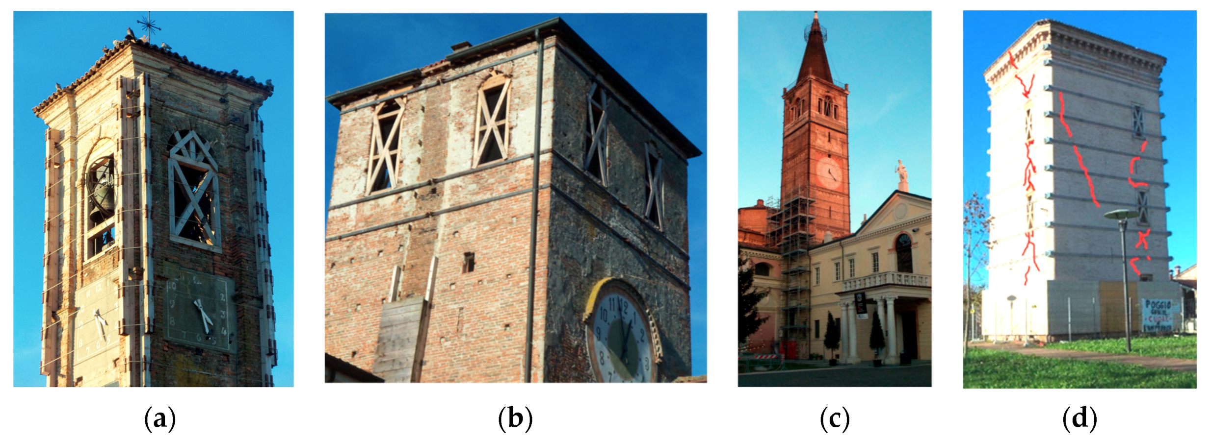
Figure 1.
Examples of seismic damage of towers: damage of the belfry (a); (b) damages caused by the several discontinuities; (c) the adjacent structures complicate the structural behaviours, (d) the position of the openings and the effects of the past interventions (d).
Figure 1.
Examples of seismic damage of towers: damage of the belfry (a); (b) damages caused by the several discontinuities; (c) the adjacent structures complicate the structural behaviours, (d) the position of the openings and the effects of the past interventions (d).

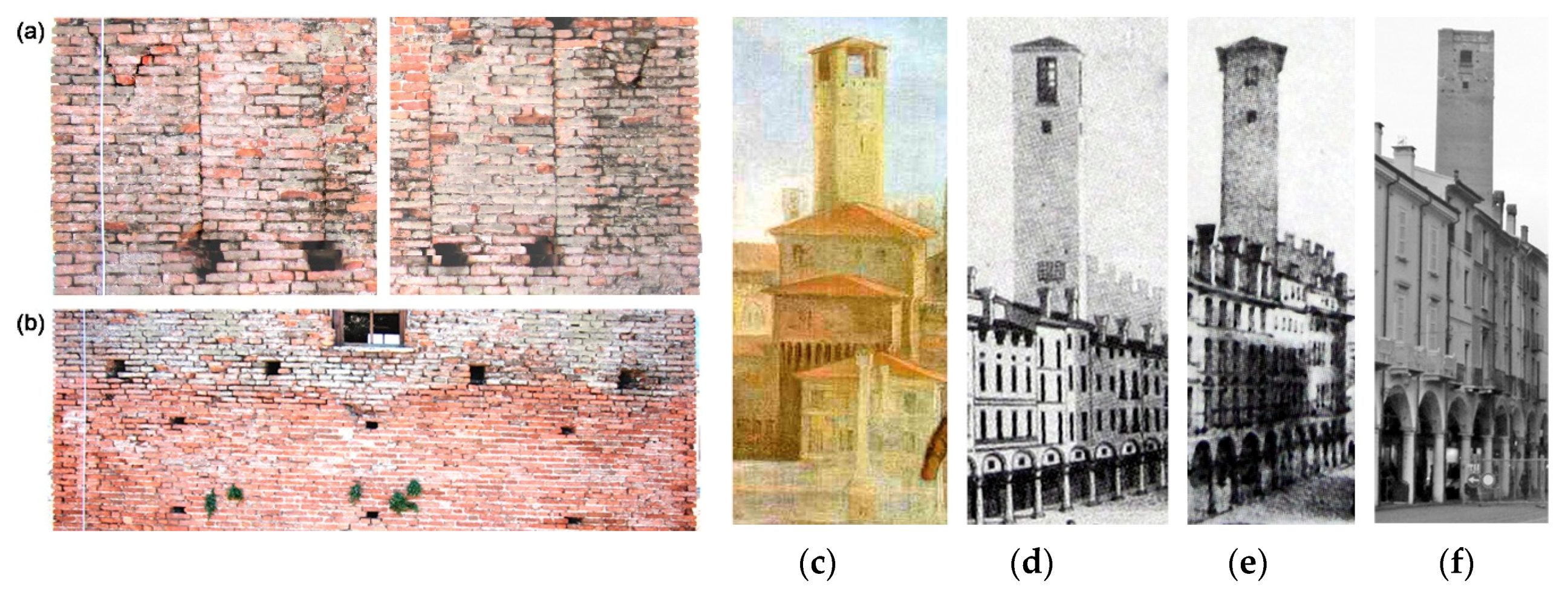
Figure 2.
Structural discontinuities detected in the upper part of the Gabbia Tower in Mantua: (a) probable merlons embedded in the masonry texture; (b) change in the surface workmanship at about 8.0 m from the top; views dated back to (c) XVII century; (d) 1830; (e) 1852 and (f) present day [10].
Figure 2.
Structural discontinuities detected in the upper part of the Gabbia Tower in Mantua: (a) probable merlons embedded in the masonry texture; (b) change in the surface workmanship at about 8.0 m from the top; views dated back to (c) XVII century; (d) 1830; (e) 1852 and (f) present day [10].

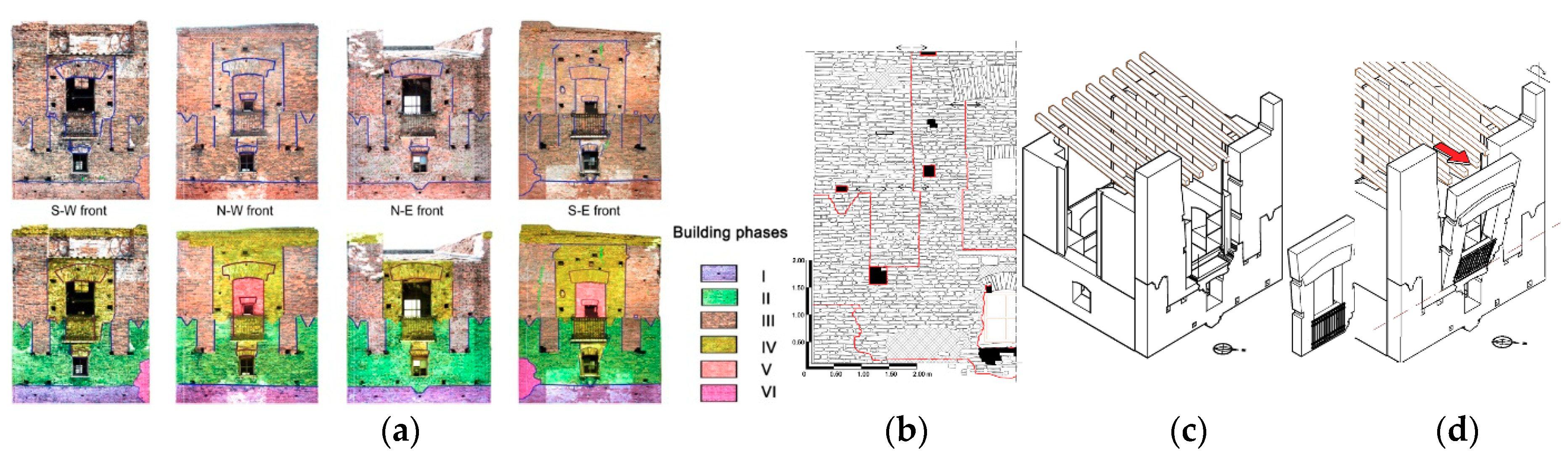
Figure 3.
Supposed building phases: (a) Hypothesis about the evolution of the tower top (I) first building up to 46 m; (II) an addition up to the merlon level; (III) the adding of 4 corner piers supporting a for side roof; (IV) opening infilling and construction of the windows, crowning and the new roof; (V) the south corner repair [10]; (b) survey of the surface discontinuities; (c) mapping of unrestrained masonry portions and (d) hypothesis of possible cinematic mechanism during an earthquake.

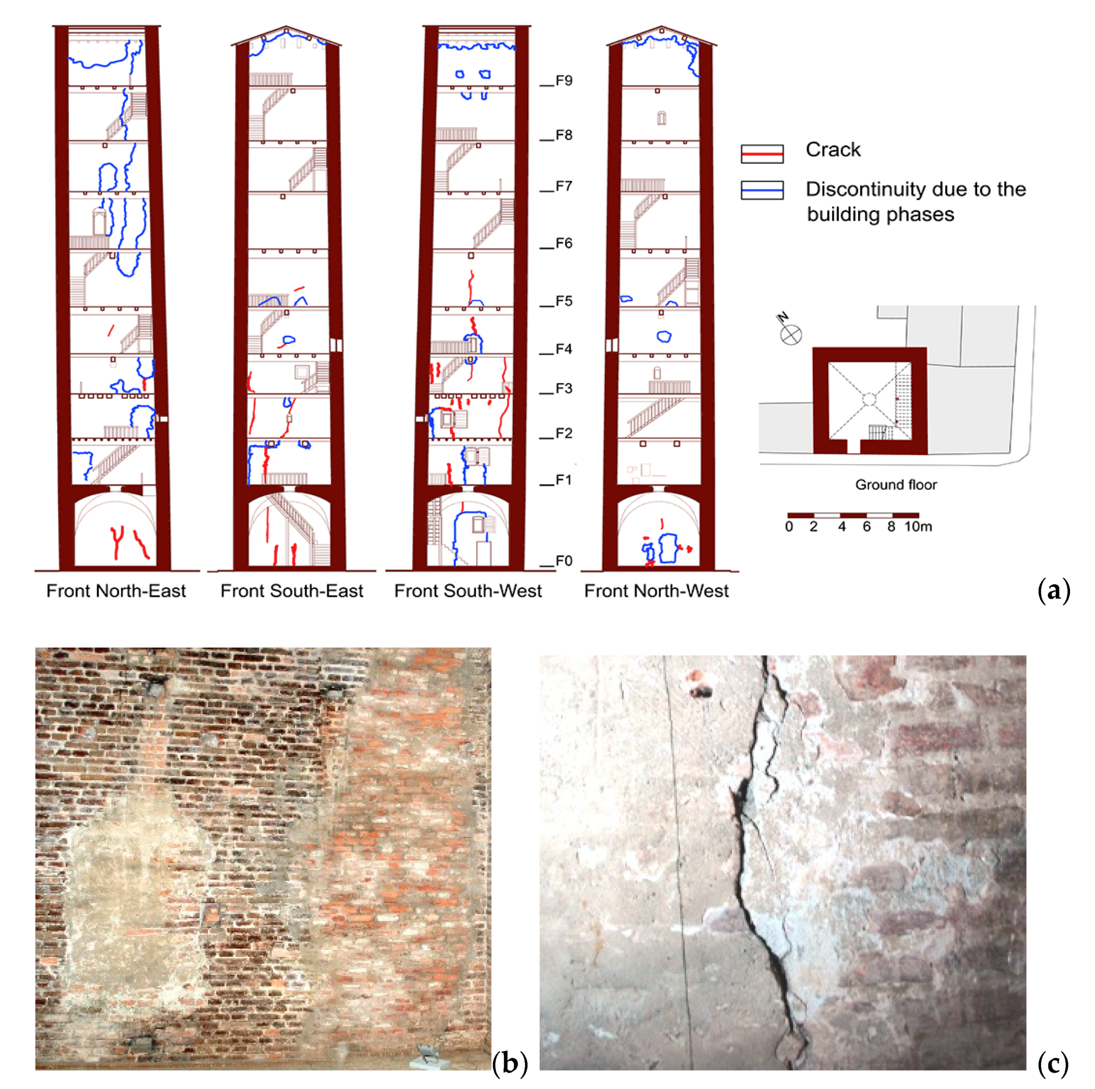
Figure 4.
Section of the Zuccaro’s Tower in Mantua with the survey of the crack pattern and of the discontinuities (a); the masonry appears fragmentary (b); minor structural movements could detach local discontinuities, propagating cracks (c).
Figure 4.
Section of the Zuccaro’s Tower in Mantua with the survey of the crack pattern and of the discontinuities (a); the masonry appears fragmentary (b); minor structural movements could detach local discontinuities, propagating cracks (c).

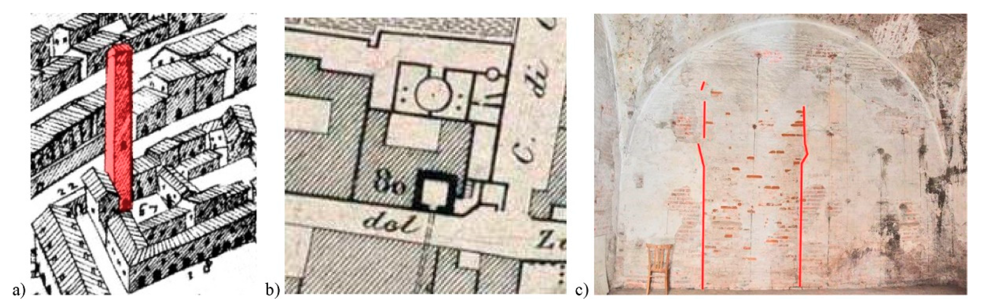
Figure 5.
Zuccaro’s Tower in Mantua in historic maps: (a) G. Bertazzolo, Mantua Descriptio Urbis, 1628; (b) G. Raineri, Map of the Royal city of Mantua, 1831 (Mantua State Archive) The first picture of the building conforms to the current layout with a large window in the south–west front (Figure 1a). The tower appears surrounded by low buildings, on two sides, with an opening toward a courtyard at the north–east. The opening is no more present nowadays, but its layout is clearly recognizable thought the survey of the front surfaces (c).

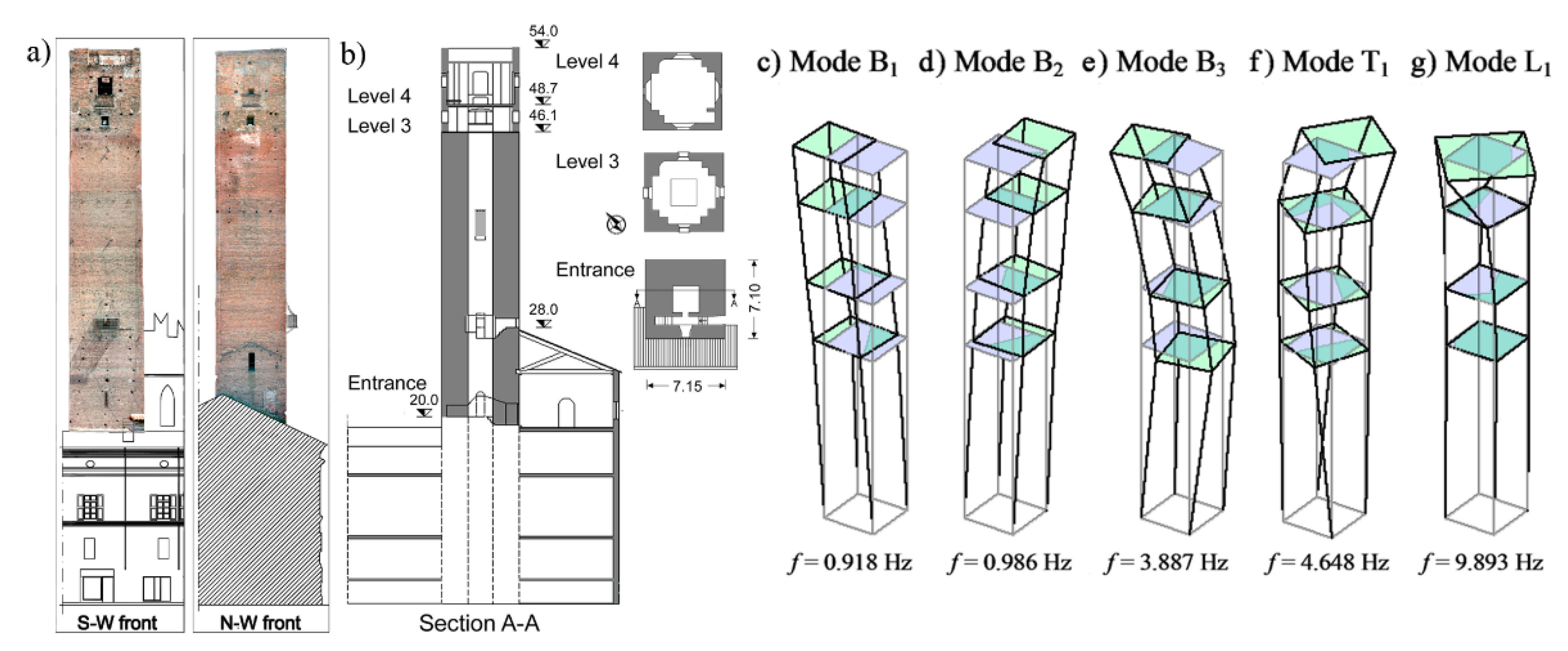
Figure 6.
Gabbia Tower in Mantua. (a) Fronts and (b) section of the Tower. The last identified modes involve deflections of the upper portion of the tower, evidence of the structural effect of the surveyed changes of the structural layout, masonry quality and morphology [20] (f: frequency).
Figure 6.
Gabbia Tower in Mantua. (a) Fronts and (b) section of the Tower. The last identified modes involve deflections of the upper portion of the tower, evidence of the structural effect of the surveyed changes of the structural layout, masonry quality and morphology [20] (f: frequency).

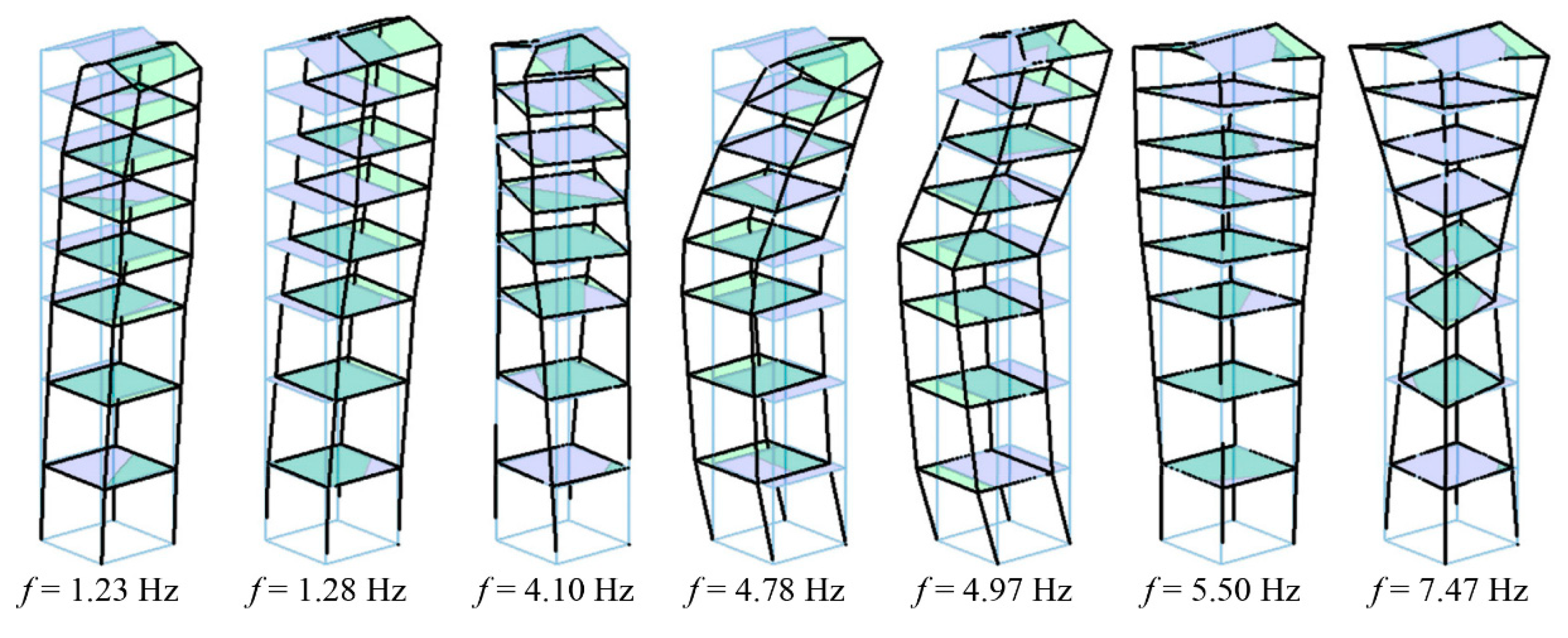
Figure 7.
Zuccaro’s Tower in Mantua. The highest modes identified from ambient vibration measurements show warping distortion of the cross-sections (f: frequency). In addition, most mode shapes seem to exhibit curvature change or increase around the 6th level, where the direct survey of the north–east side highlighted sharp discontinuities (Figure 4).

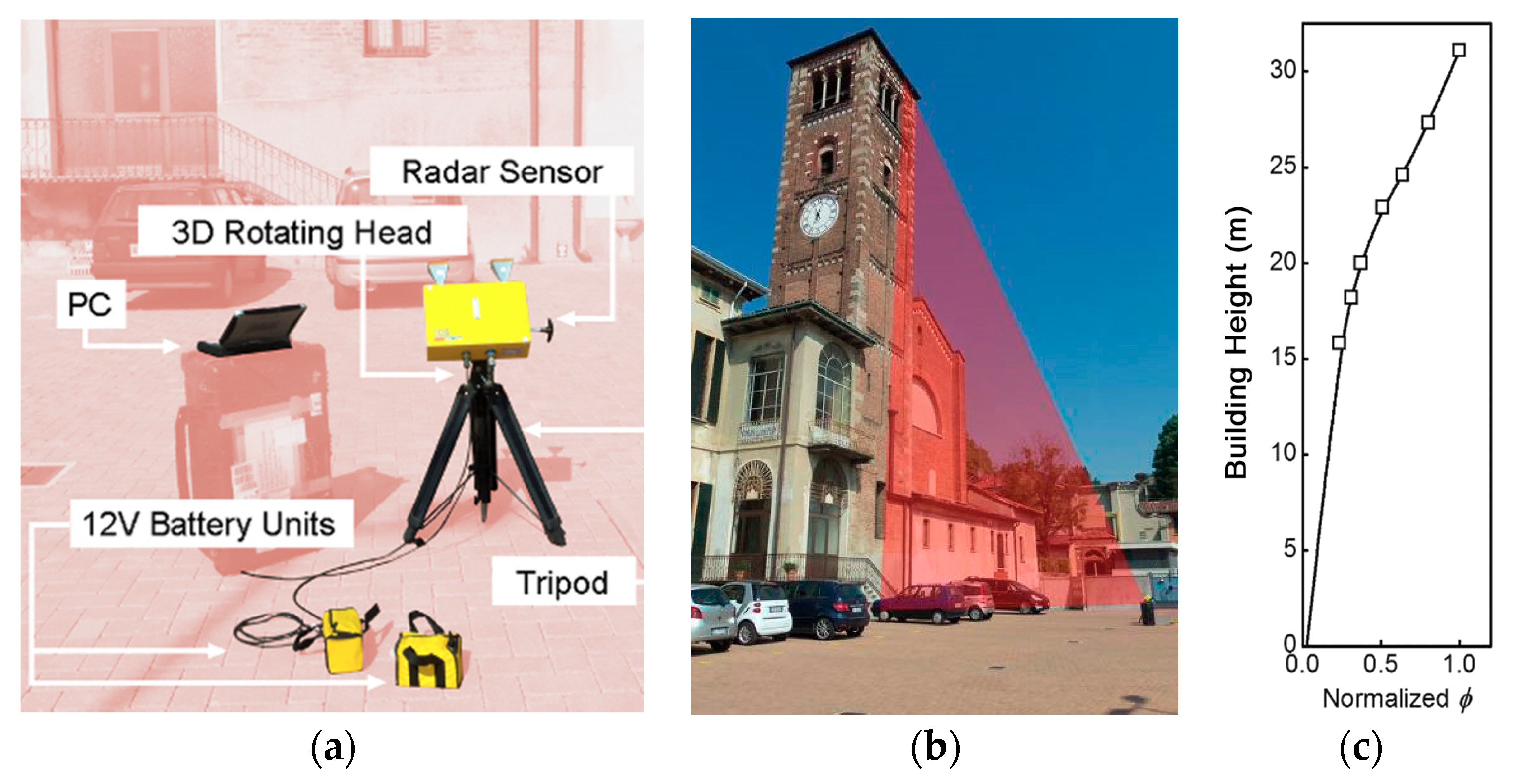
Figure 8.
Carrobiolo Bell Tower in Monza: (a) Microwave interferometer (IDS, model IBIS-S); (b) Radar position in the dynamic test of the tower; (c) Mode shape (Φ) associated to the fundament frequency (f = 1.93 Hz, ambient excitation) [21].
Figure 8.
Carrobiolo Bell Tower in Monza: (a) Microwave interferometer (IDS, model IBIS-S); (b) Radar position in the dynamic test of the tower; (c) Mode shape (Φ) associated to the fundament frequency (f = 1.93 Hz, ambient excitation) [21].


Figure 10.
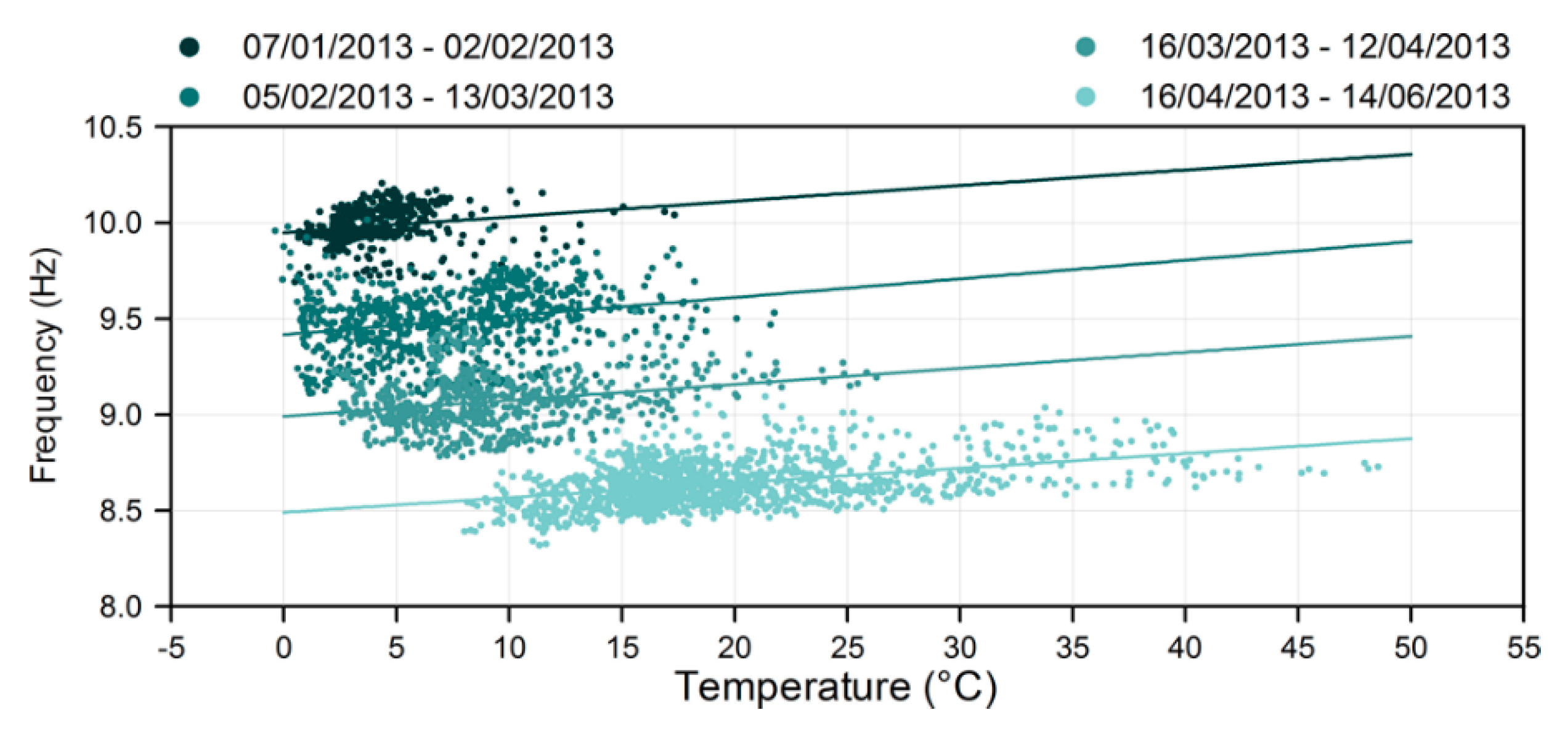
Gabbia Tower in Mantua. Natural frequency of the local mode L1 of Figure 1 plotted with respect to the outdoor temperature. The natural frequency exhibits clearly decrease in time, detecting possible damage; the clouds of temperature-frequency points, corresponding to each of the 4 reference periods, are characterized by similar slope of the best fit line [20].
Figure 10.
Gabbia Tower in Mantua. Natural frequency of the local mode L1 of Figure 1 plotted with respect to the outdoor temperature. The natural frequency exhibits clearly decrease in time, detecting possible damage; the clouds of temperature-frequency points, corresponding to each of the 4 reference periods, are characterized by similar slope of the best fit line [20].

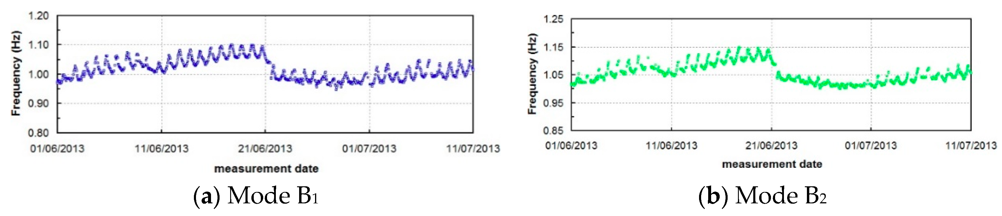
Figure 11.
Gabbia Tower in Mantua. Zoom of the natural frequency of modes B1 (a) and B2 (b) in the period between 01/06/2013 and 10/07/2013. The frequency shifts down highlight the effects of the Garfagnana earthquake [20].
Figure 11.
Gabbia Tower in Mantua. Zoom of the natural frequency of modes B1 (a) and B2 (b) in the period between 01/06/2013 and 10/07/2013. The frequency shifts down highlight the effects of the Garfagnana earthquake [20].

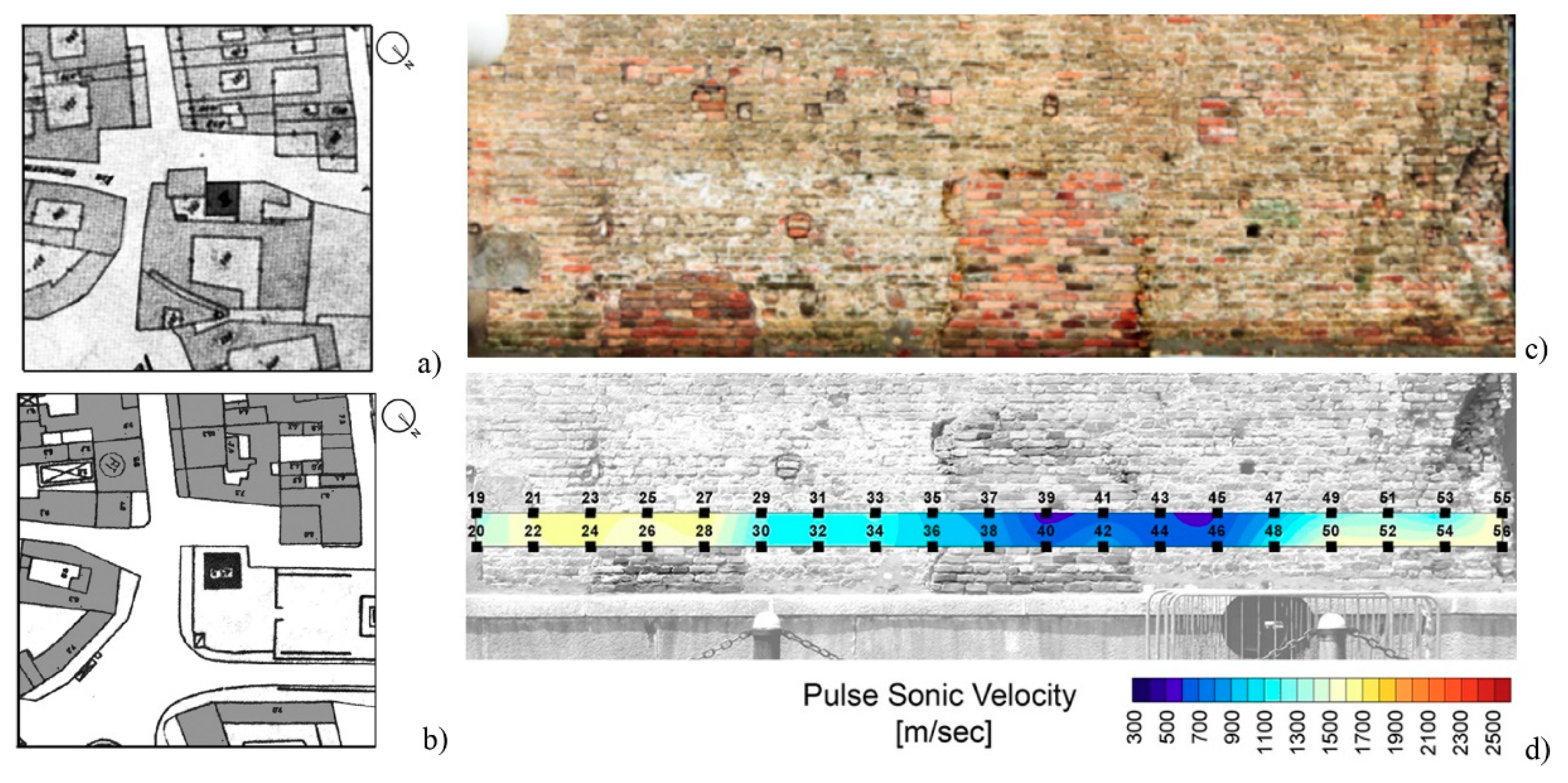
Figure 12.
Layout of the Isso Tower area in a map of Castelleone dated back to 1901 (a) and recent one (b) where the tower appears isolated; the surrounding buildings were demolished but their presence explains the presence of infilled openings and other irregularities of the masonry texture (c). Pulse sonic velocity test (d) confirmed lower compactness materials. The numbers in (d) are the acquisition points [33].

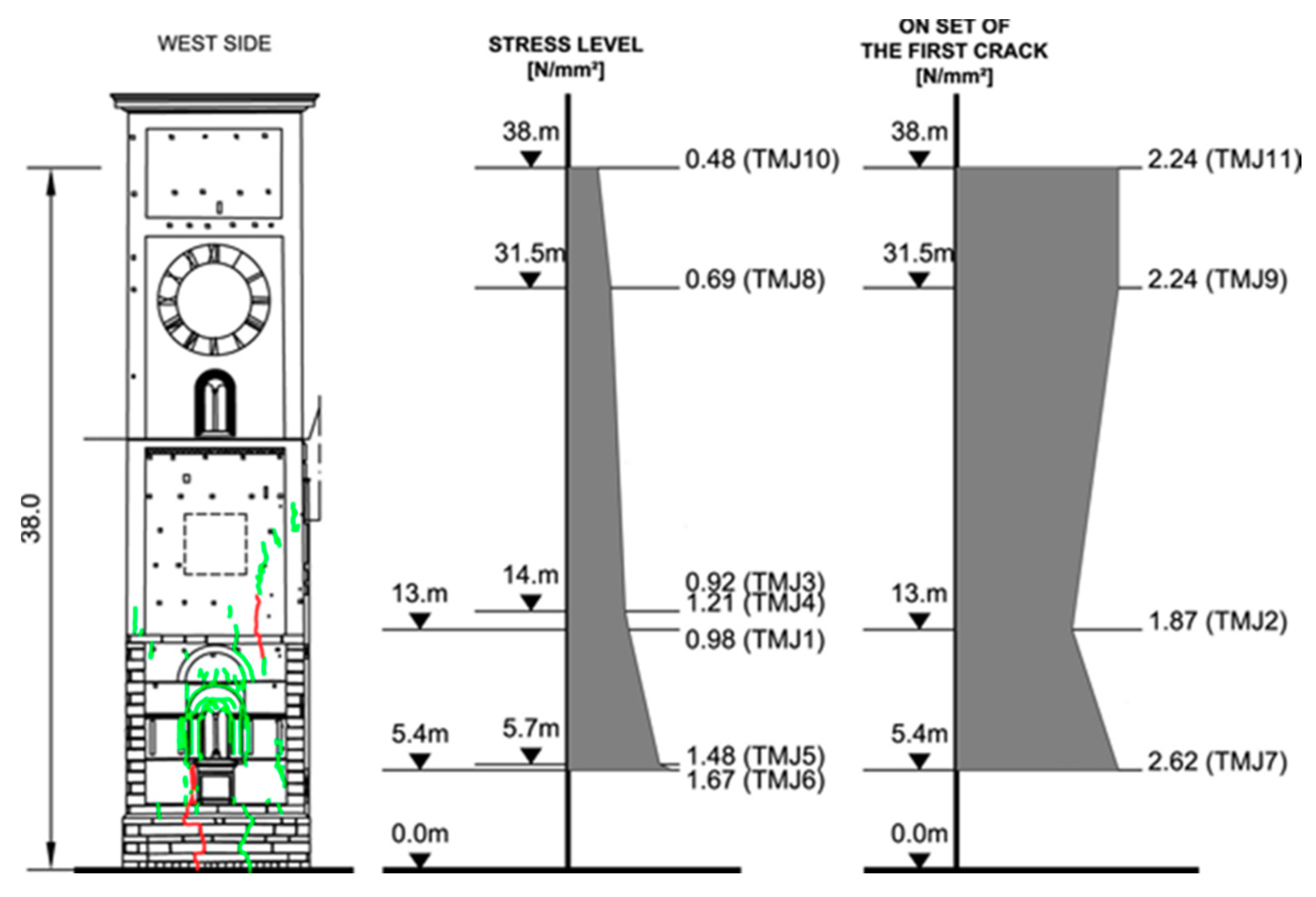
Figure 13.
Bell Tower of the Monza Cathedral. Comparison between the distribution of the local state of stress measured by single flat-jack test and the stress on set of the first crack by double flat-jack test [16].
Figure 13.
Bell Tower of the Monza Cathedral. Comparison between the distribution of the local state of stress measured by single flat-jack test and the stress on set of the first crack by double flat-jack test [16].

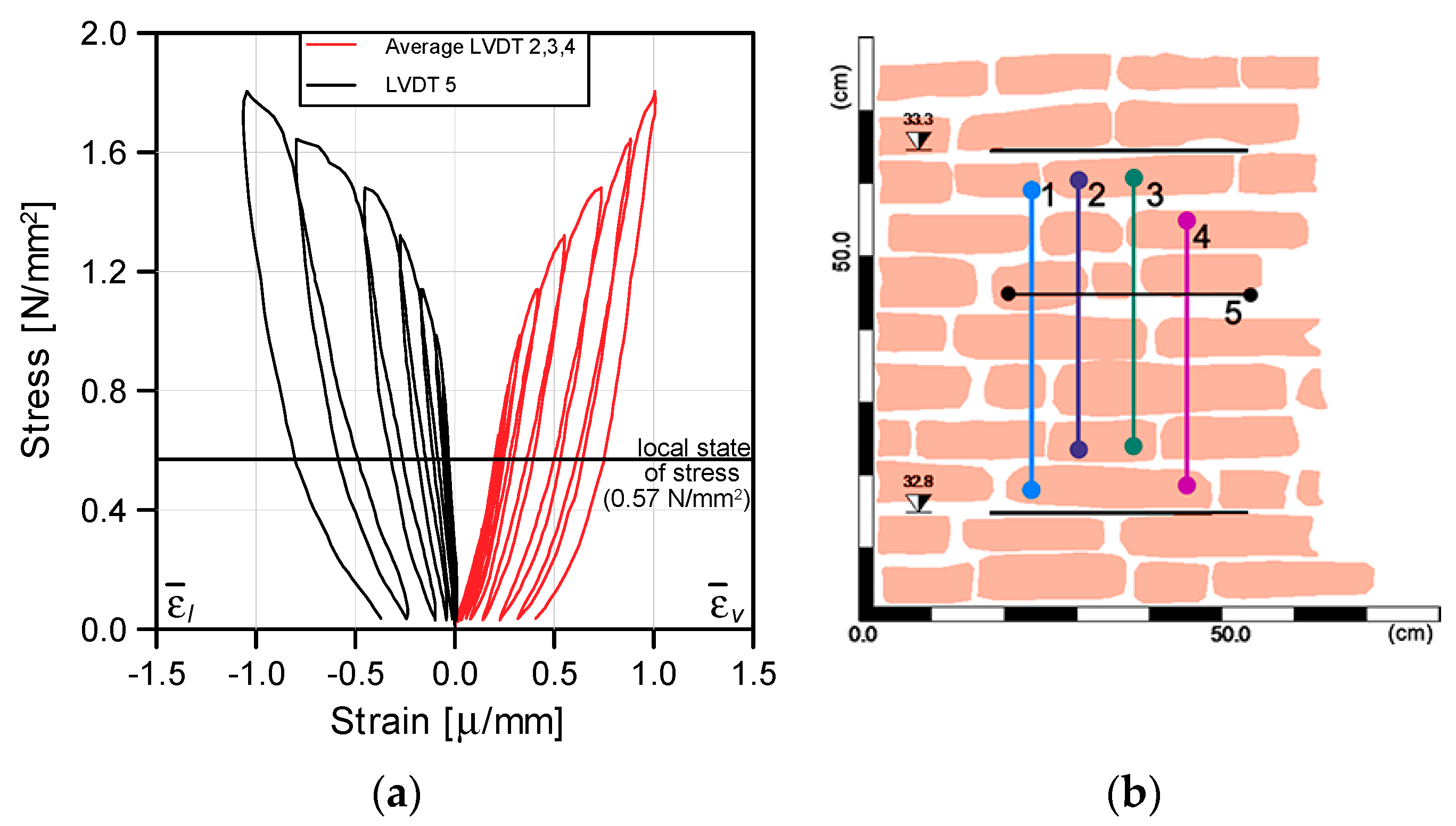
Figure 14.
Results of the double flat jack test (a) and (b) survey superficial texture of the investigated area [16].
Figure 14.
Results of the double flat jack test (a) and (b) survey superficial texture of the investigated area [16].

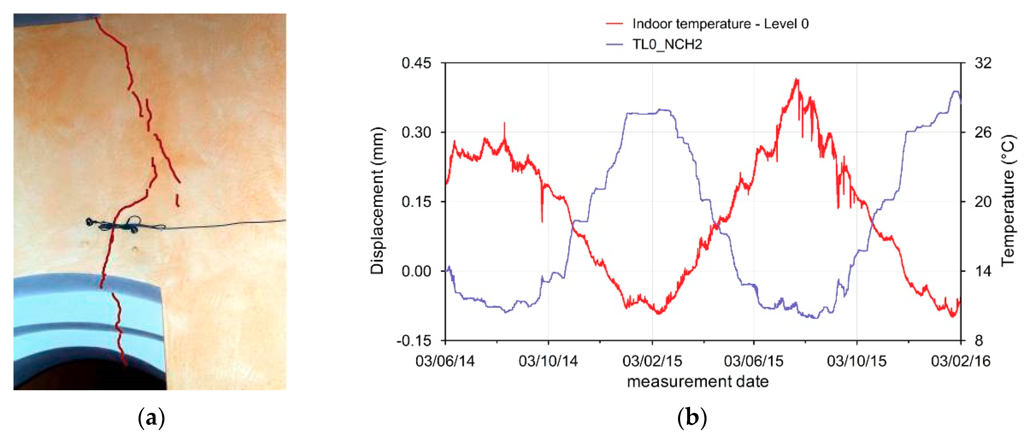
Figure 15.
(a) Position of the sensor; (b) measurements indicating prevalent thermal effects on the crack opening [21].
Figure 15.
(a) Position of the sensor; (b) measurements indicating prevalent thermal effects on the crack opening [21].

Publisher’s Note: MDPI stays neutral with regard to jurisdictional claims in published maps and institutional affiliations. |
© 2020 by the authors. Licensee MDPI, Basel, Switzerland. This article is an open access article distributed under the terms and conditions of the Creative Commons Attribution (CC BY) license (http://creativecommons.org/licenses/by/4.0/).
Share and Cite
MDPI and ACS Style
Saisi, A.; Gentile, C. Investigation Strategy for Structural Assessment of Historic Towers. Infrastructures 2020, 5, 106. https://0-doi-org.brum.beds.ac.uk/10.3390/infrastructures5120106
AMA Style
Saisi A, Gentile C. Investigation Strategy for Structural Assessment of Historic Towers. Infrastructures. 2020; 5(12):106. https://0-doi-org.brum.beds.ac.uk/10.3390/infrastructures5120106
Chicago/Turabian StyleSaisi, Antonella, and Carmelo Gentile. 2020. "Investigation Strategy for Structural Assessment of Historic Towers" Infrastructures 5, no. 12: 106. https://0-doi-org.brum.beds.ac.uk/10.3390/infrastructures5120106