
Urban Planning for Climate Change: A Toolkit of Actions for an Integrated Strategy of Adaptation to Heavy Rains, River Floods, and Sea Level Rise


Abstract
:1. Introduction
- Update the descriptive apparatus of the local urban plan highlighting and relating the areas at risk with the plan forecasts on those same areas;
- Integrate the prescriptive apparatus of the local urban plan with climate-proof and site-specific adaptation actions (a first result, preparatory to this purpose, is expressed in this contribution with the conceptualisation of the toolkit of adaptation actions to heavy rains and river flood phenomena, and sea level rise, presented in Section 4).
- An analysis of the impacts and vulnerabilities of territories exposed to risk;
- The adoption of defence and risk mitigation measures with a short and medium-term time horizon;
- The adoption of adaptation strategies with a long-term time horizon;
- The monitoring of actions over time.
- 93% of cities are facing significant risks due to climate change;
- Only 59% of cities have conducted a climate risk vulnerability assessment to date;
- 43% of cities, representing a projected population of over 400 million people by 2030, still do not have any adaptation plan to address climate risks;
- 60% of cities have water safety problems;
- Only 46% of cities include water security in their vulnerability assessments even though water is one of the cornerstones of mitigation and adaptation actions.
The Impacts of Climate Change on the Systemic Components of the City
2. Materials
2.1. State-of-the-Art: “Defence”, “Adaptation”, and “Relocation/De-Anthropisation” as Strategic Responses to the Effects of Climate Change on the Territory
- Defend the territory from the effects of sea level rise on coastal cities through engineering works aimed at “securing” areas exposed to potential flood risks on the base of sea level rise projections to 2100;
- Increase the resilience of the urban structure to flooding phenomena through strategies capable of adapting the urban form to the environmental context through actions of reconfiguration of morphological components, considering flexibility and diversity as priority elements [29]. Basically, actions that take the form of real opportunities to implement an ecological transition of territories damaged by climate change;
- Relocate activities and settlements present in areas exposed to greater risk to other geomorphologically safer, even if the investment cost for mitigation is considered unsustainable, thus giving priority to the survival of the area itself [30].
2.2. State-of-Advancement: Integration of Macro-Strategies with the Systemic Component of the Territory for a Critical Reading of Best Practices
- Ecological–Environmental system;
- Settlement system;
- Infrastructure and Services system.
3. Method
- Phase 1|Elaboration of a matrix that relates each selected best practice (concerning a specific phenomenon) with the prevailing macro-strategy (“defence”, “adaptation”, and “relocation/de-anthropisation”) and with the system most involved in the adaptation intervention (“Ecological –Environmental”, “Settlement”, and “Infrastructure and Services”);
- Phase 2|Description and critical analysis of strategies, goals, and actions;
- Phase 3|Presentation of the results: summary of the specific actions in a toolkit.
3.1. Phase 1. Selection of Best Practices
- Billion Oyster Project (New York City, USA), another winning project of the Rebuild by Design competition. The project aims to defend the coast from sea level rise and its actions mainly involve the Ecological–Environmental System [43];
- The Climate District in Østerbro (Copenhagen, DK). The project aims to respond to the frequent floods that affect the city every year and its actions directly involve the Settlement System in its entirety [44];
- Enghaveparken—Climate Park (Copenhagen, DK). The project aims to respond to the frequent floods that affect the city every year and its actions involve more directly Infrastructure and Services System [45];
3.2. Phase 2. Critical Description and Comparative Analysis of the Best Practices Selected: Strategies, Goals, and Actions
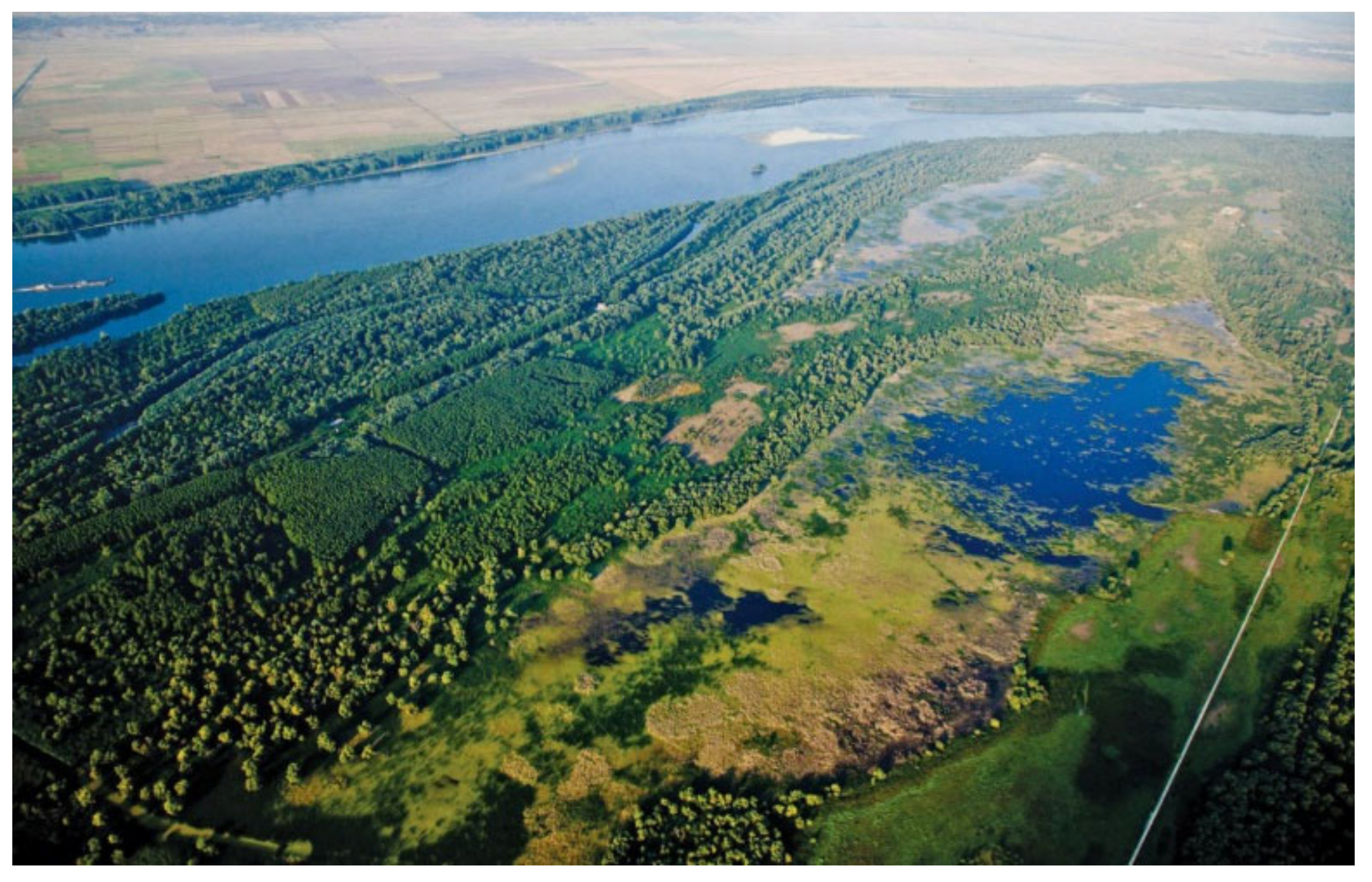
- Lower Danube Green corridor
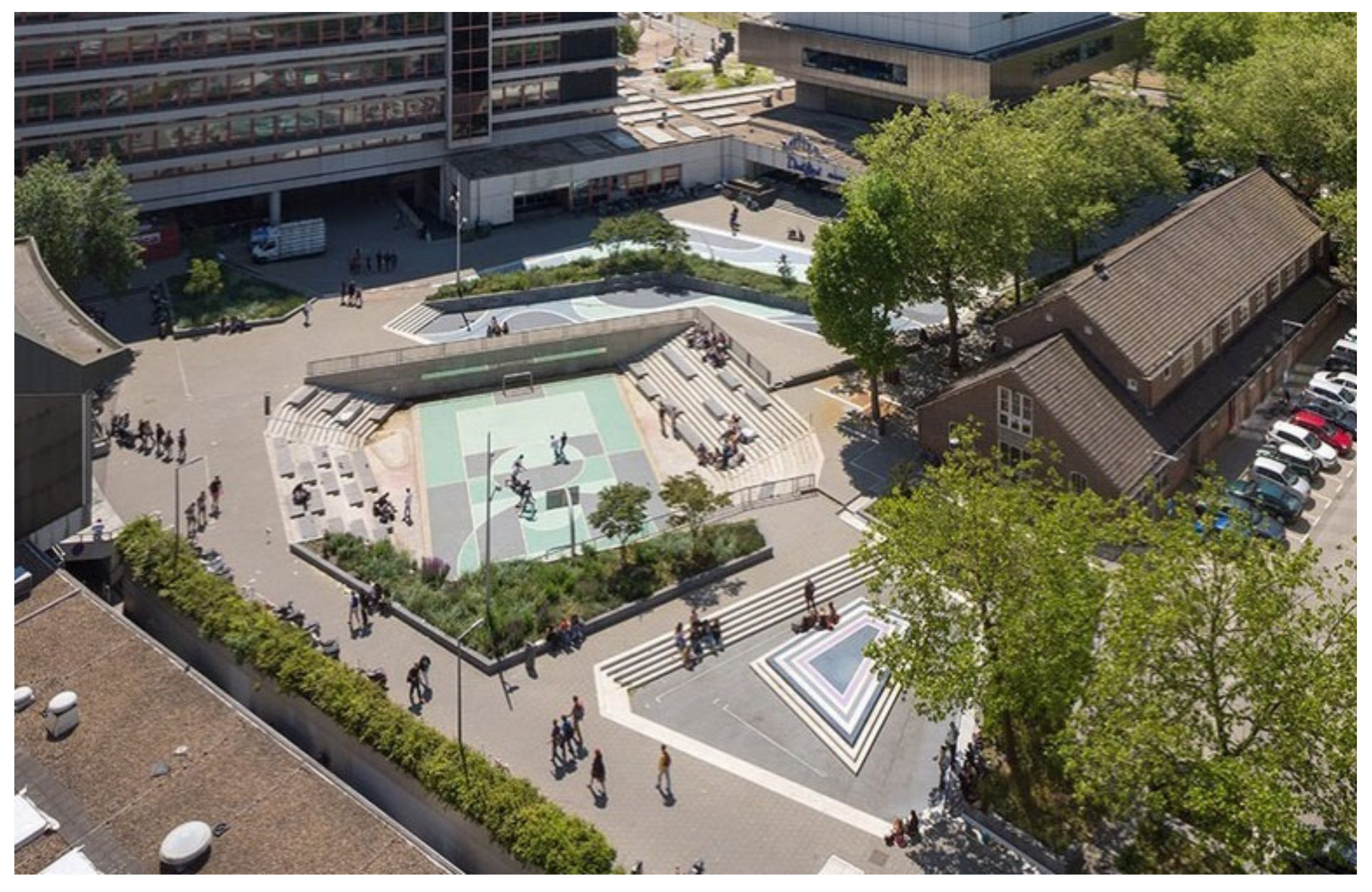
- Waterplain in Benthemplein
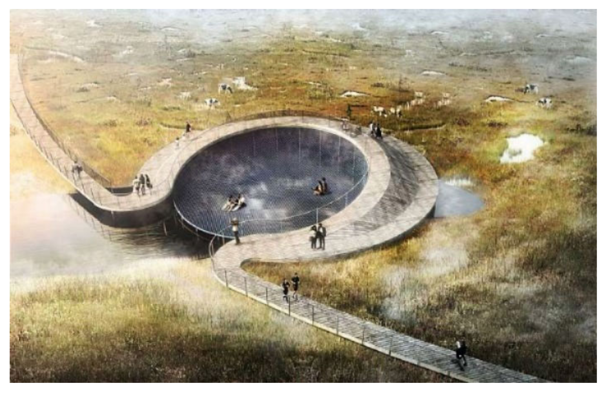
- Storkeengen (Stork Meadow)
- Coastal Planning in Ugento
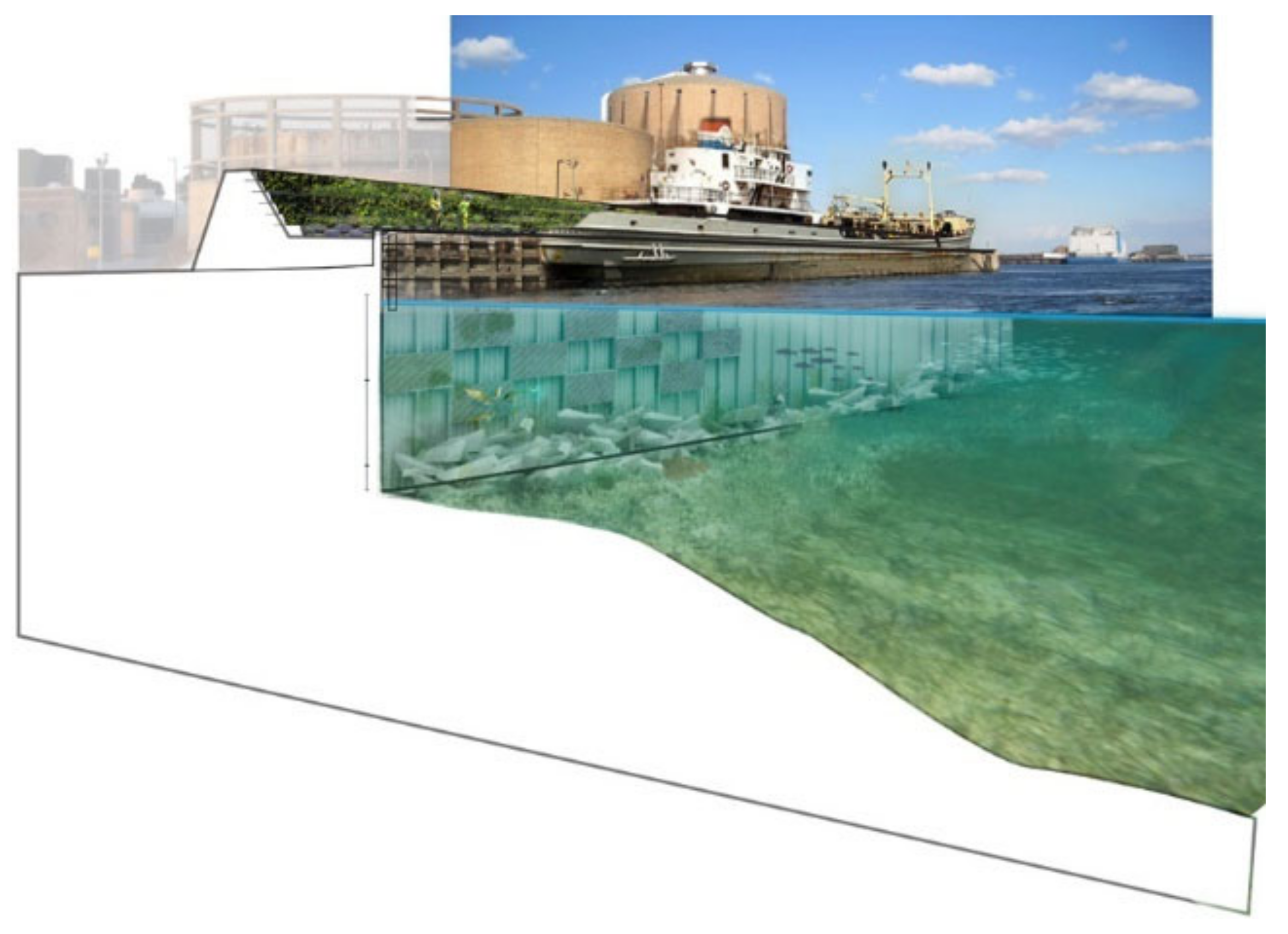
- Hamburg floading city
- Hunts Point Lifelines
4. Phase 3. Results: Toolkit of Integrated Adaptation Strategies and Actions
- (a)
- The time horizon of implementation (short, medium, long);
- (b)
- The scope of application (physical, organisational, economic);
- (c)
- The level of effectiveness (payback time).
5. Conclusions and Future Developments
- The OPPLA platform aims to share practical knowledge on natural capital, ecosystem services, and nature-based solutions, offering a wide range of case studies, products and tools [38];
- The NATURVATION project produces an atlas of a thousand examples of nature-based solutions from 100 European cities that contribute to adapting the urban system to climate change [39];
- The ThinkNature platform is a real hub of nature-based solutions, which also offers interactive experiences to allow the user to experience the application of the solutions on a climate-proof “ideal city” [40];
- The Natural Water Retention Measures platform collects information on green infrastructure applied to the water sector, with an extensive catalogue of actions and case studies [41];
- The Panorama EbA platform facilitates the sharing of case studies and examples of EbA from different regions and ecosystems around the world and is organised as a real search engine, through which everybody can search for the desired project solutions [42].
Author Contributions
Funding
Institutional Review Board Statement
Informed Consent Statement
Data Availability Statement
Conflicts of Interest
References
- IPCC. Summary for Policymakers; IPCC: Geneva, Switzerland, 2013; Available online: https://www.ipcc.ch/site/assets/uploads/2018/02/WG1AR5_SPM_FINAL.pdf (accessed on 23 May 2022).
- UNISDR. Annual Report 2012 How to Make Cities Resilient. 2012. Available online: https://www.undrr.org/publication/unisdr-annual-report-2012 (accessed on 9 June 2022).
- UNFCCC. United Nations Framework Convention on Climate Change. 2015. Available online: https://unfccc.int/resource/docs/convkp/conveng.pdf (accessed on 9 June 2022).
- UN. 2030 Agenda for Sustainable Development; UN: New York, NY, USA, 2015. [Google Scholar]
- EEA. Climate Change, Impacts and Vulnerability in Europe; EEA: Copenhagen, Denmark, 2016; Available online: https://www.eea.europa.eu/publications/climate-change-impacts-and-vulnerability-2016 (accessed on 14 July 2022).
- Climate ADAPT; Secretariat of the Convention on Biological Diversity. Voluntary Guidelines for the Design and Effective Implementation of Ecosystem-Based Approaches to Climate Change Adaptation and Disaster Risk Reduction and Supplementary Information; Technical Series No. 93; Secretariat of the Convention on Biological Diversity: Montreal, QC, Canada, 2019. [Google Scholar]
- Mariano, C.; Marino, M. Water Landscapes: From risk management to an urban regeneration strategy. UPLanD-J. Urban Plan. Landsc. Environ. Des. 2018, 3, 55–74. [Google Scholar] [CrossRef]
- IUCN. Ecosystem-Based Approaches to Climate Change Adaptation. Available online: https://www.iucn.org/theme/ecosystem-management/our-work/ecosystem-based-approaches-climate-change-adaptation (accessed on 15 July 2022).
- Bertilsson, L.; Wiklund, K.; de Moura Tebaldi, I.; Rezende, O.M.; Veról, A.P.; Miguez, M.G. Urban flood resilience-A multi-criteria index to integrate flood resilience into urban planning. J. Hydrol. 2019, 573, 970–982. [Google Scholar] [CrossRef]
- COM. Forging a Climate-Resilient Europe—The New EU Strategy on Adaptation to Climate Change; European Commission: Brussels, Belgium, 2021; Available online: https://eur-lex.europa.eu/legal-content/EN/TXT/PDF/?uri=CELEX:52021DC0082&from=EN (accessed on 23 July 2022).
- Mariano, C.; Marino, M. Defense, adaptation and relocation. Three strategies for urban planning of coastal areas at risk of flooding. In Proceedings of the INPUT aCAdemy 2019 Planning, Nature and Ecosystem Services Conference, Cagliari, Italy, 24–26 June 2019. [Google Scholar]
- CDP; ICLEI. Cities on the Route to 2030. Building a Zero Emissions, Resilient Planet for All. Report. 2021. Available online: https://cdn.cdp.net/cdp-production/cms/reports/documents/000/005/759/original/CDP_Cities_on_the_Route_to_2030.pdf?1621329680 (accessed on 14 July 2022).
- Catalano, C.; Andreucci, M.B.; Guarino, R.; Bretzel, F.; Manfredi, L.; Pasta, S. (Eds.) Urban Services to Ecosystems: Green Infrastructure Benefits from the Landscape to the Urban Scale; Future City 17; Springer Nature: Berlin/Heidelberg, Germany, 2021. [Google Scholar] [CrossRef]
- Kabisch, N.; Korn, H.; Stadler, J.; Bonn, A. Nature-Based Solutions to Climate Change Adaptation in Urban Areas. Linkages between Science, Policy and Practice; Theory and Practice of Urban Sustainability Transitions (TPUST); Springer: Cham, Switzerland, 2017; Available online: https://0-link-springer-com.brum.beds.ac.uk/content/pdf/10.1007/978-3-319-56091-5.pdf (accessed on 23 July 2022). [CrossRef]
- Oliva, F.; Ricci, L. Promoting urban regeneration and redevelopment of the existing building stock. In Architecture, City, Territory towards the Green Economy; Antonini, E., Tucci, F., Eds.; Edizioni Ambiente: Milan, Italy, 2017. [Google Scholar]
- Egerer, M.; Haase, D.; McPhearson, T.; Frantzeskaki, N.; Andersson, E.; Nagendra, H.; Ossola, A. Urban change as an untapped opportunity for climate adaptation. Npj Urban Sustain. 2021, 1, 22. [Google Scholar] [CrossRef]
- UN-HABITAT. Climate Proofing Toolkit for Basic Urban Infrastructure, with a Focus on Water and Sanitation. 2021. Available online: https://unhabitat.org/sites/default/files/2021/09/climate_proofing_toolkit_2021_option_b.pdf (accessed on 23 July 2022).
- García, A.M.; Ónega, F.J.; Crecente, R.; van Holst, F.; Abts, E.; Timmermans, W.; Stolk, M. F:ACTS!: Forms for Adapting to Climate change through Territorial Strategies. 2014. Available online: https://www.researchgate.net/publication/283416836_FACTS_Forms_for_adapting_to_climate_change_through_territorial_strategies_the_handbook (accessed on 23 July 2022).
- Birkmann, J.; Garschagen, M.; Kraas, F.; Quang, N. Adaptive urban governance: New challenges for the second generation of urban adaptation strategies to climate change. Sustain. Sci. 2010, 5, 185–206. [Google Scholar] [CrossRef]
- UN-Habitat. World Cities Report 2016: Urbanization and Development—Emerging Futures. 2016. Available online: https://unhabitat.org/world-cities-report-2016 (accessed on 11 May 2022).
- Mehrotra, S.; Zusman, E.; Bajpai, J.; Fedirko, L.; Jacob, K.; Replogle, M.; Black, J. Urban Transportation. In Climate Change and Cities: Second Assessment Report of the Urban Climate Change Research Network; Rosenzweig, C., Solecki, W., Romero-Lankao, P., Mehrotra, S., Dhakal, S., Ali Ibrahim, S., Eds.; Cambridge University Press: Cambridge, UK, 2018; pp. 491–518. [Google Scholar] [CrossRef]
- Mariano, C.; Marino, M.; Pisacane, G.; Sannino, G. Sea level rise and Coastal Impacts: Innovation and Improvement of the Local Urban Plan for a Climate-Proof Adaptation Strategy. Sustainability 2021, 13, 1565. [Google Scholar] [CrossRef]
- EC. 100 Climate Neutral Cities by 2030 by and for the Citizens; European Commission: Brussels, Belgium, 2020; Available online: https://ec.europa.eu/jrc/communities/sites/jrccties/files/100_climate_neutral_cities_report_pdf (accessed on 14 July 2022).
- Geneletti, D.; Cortinovis, C.; Zardo, L.; Adem Esmail, B. Planning for Ecosystem Services in Cities; Springer Nature: Cham, Switzerland, 2020. [Google Scholar]
- Millennium Ecosystem Assessment. Ecosystems and Human Well-Being: Synthesis; Island Press: Washington, DC, USA, 2005; Available online: https://www.millenniumassessment.org/documents/document.356.aspx.pdf (accessed on 20 July 2022).
- Musco, F.; Maragno, D.; Ruzzante, F.; Negretto, V. Climate Proof Planning: The Use of Remote Sensing to Support Local Scale Vulnerability. GEO Media No. 1. 2019. Available online: https://mediageo.it/ojs/index.php/GEOmedia/article/view/1562/1462 (accessed on 23 May 2022).
- Mariano, C.; Marino, M. Climate-Proof Planning: Water as Engine of Urban Regeneration in the Ecological Transition Era; Springer: Berlin/Heidelberg, Germany, 2022. [Google Scholar]
- Davoudi, S.; Crawford, J.; Mehmood, A. (Eds.) Planning for Climate Change: Strategies for Mitigation and Adaptation for Spatial Planners, 1st ed.; Routledge: Abingdon, UK, 2009; Available online: https://0-doi-org.brum.beds.ac.uk/10.4324/9781849770156 (accessed on 23 July 2022). [CrossRef]
- Boller, G. Landscape as urban infrastructure for flood risk mitigation. In Public Action for Risk Prevention, Proceedings 20th SIU National Conference; Planum: Rome, Italy, 2017. [Google Scholar]
- Ryan, B.D.; Vega-Barachowitz, D.; Perkins-High, L. Rising Tides: Relocation and Sea Level Rise in Metropolitan Boston; Norman B. Leventhal Center for Advanced Urbanism: Cambridge, MA, USA, 2015; Available online: https://lcau.mit.edu/sites/lcau.mit.edu/files/attachments/project/RisingTides_ProjectPrimer.pdf (accessed on 12 July 2022).
- WHO. A Health Perspective on the Role of the Environment in One Health; WHO: Geneva, Switzerland, 2022. [Google Scholar]
- Istat. BES 2020 Report; Istat: Rome, Italy, 2020; Available online: https://www.istat.it/it/files//2021/03/BES_2020.pdf (accessed on 23 May 2022).
- Ricci, L.; Mariano, M. The urban design of the Anagnina Romanina centrality. Ananke 2019, 87, 108–113. [Google Scholar]
- Council of Europe. European Landscape Convention. 2000. Available online: https://rm.coe.int/1680080621 (accessed on 11 July 2022).
- Marino, M. The experimental dimension of the urban project. In Il Progetto Urbano in Tempo di Crisi; Ferretti, L.V., Mariano, C., Eds.; FrancoAngeli: Milan, Italy, 2021; pp. 187–206. [Google Scholar]
- EEA. Nature-Based Solutions in Europe: Policy, Knowledge and Practice for Climate Change Adaptation and Disaster Risk Reduction; Report No. 01/2021; EEA: Copenhagen, Denmark, 2021; Available online: https://www.eea.europa.eu/publications/nature-based-solutions-in-europe (accessed on 14 July 2022).
- COM. Communication from the Commission to the European Parliament, the Council, the European Economic and Social Committee and the Committee of the Regions. Green Infrastructure (GI)—Enhancing Europe’s Natural Capital; European Commission: Brussels, Belgium, 2013; Available online: https://eur-lex.europa.eu/resource.html?uri=cellar:d41348f2-01d5-4abe-b817-4c73e6f1b2df.0014.03/DOC_1&format=PDF (accessed on 10 July 2022).
- Oppla. Available online: https://oppla.eu/nbs/case-studies (accessed on 15 July 2022).
- Naturvation. Available online: https://naturvation.eu/ (accessed on 15 July 2022).
- ThinkNature. Available online: https://www.think-nature.eu/ (accessed on 15 July 2022).
- Natural Water Retention Measures. Available online: http://nwrm.eu/ (accessed on 15 July 2022).
- EbA Panorama. Available online: https://panorama.solutions/en/portal/panorama-eba (accessed on 15 July 2022).
- Billion Oyster Project. Available online: https://www.billionoysterproject.org/ (accessed on 23 July 2022).
- The First Climate District. Available online: https://www.tredjenatur.dk/en/portfolio/the-first-climate-district/#:~:text=The%20climate%20district%20in%20%C3%98sterbro,the%20future%20climate%20friendly%20city (accessed on 23 July 2022).
- Enghaveparken—Climate Ark. Available online: https://www.tredjenatur.dk/en/portfolio/enghaveparken-climate-park/ (accessed on 23 July 2022).
- WWF. Factsheet. 2015. Available online: https://climate-adapt.eea.europa.eu/metadata/case-studies/lower-danube-green-corridor-floodplain-restoration-for-flood-protection/danube_document-1.pdf (accessed on 9 June 2022).
- De Urbanisten. Available online: https://www.urbanisten.nl/work/benthemplein (accessed on 15 July 2022).
- C.F. Møller Architects. Available online: https://www.cfmoller.com/p/Storkeengen-Stork-Meadow-i3327.html (accessed on 15 July 2022).
- Coastal Planning and the Pilot Case of Ugento: Good Practices to Mitigate the Erosion Effects. Available online: https://www.cmcc.it/lectures_conferences/coastal-planning-and-the-pilot-case-of-ugento-good-practices-to-mitigate-the-erosion-effects (accessed on 23 July 2022).
- KCAP. Hafen City, Haburg—Transformation Waterfront Future-Proof. Available online: https://www.kcap.eu/projects/9/hafencity (accessed on 15 July 2022).
- Rebuild by Design. Hunts Point Lifelines. Available online: https://www.rebuildbydesign.org/work/funded-projects/hunts-point-lifelines/ (accessed on 15 July 2022).
- Musco, F.; Maragno, D.; Magni, F.; Innocenti, A.; Negretto, V. Resilient Padua. Guidelines for Building a Climate Change Adaptation Plan. 2016. Available online: https://www.padovanet.it/sites/default/files/attachment/Linee%20guida%20per%20la%20costruzione%20del%20Piano%20di%20Adattamento%20al%20cambiamento%20climatico.pdf (accessed on 20 May 2022).
- Musco, F.; dall’Omo, C.F.; Negretto, V.; Lucertini, G.; Marango, D.; Ruzzante, F. Mantova Resiliente. Verso il Piano di Adattamento al Cambiamento Climatico—Linee Guida; Comune di Mantova: Mantua, Italy, 2018. [Google Scholar]
- Vejle Kommune. Vejle’s resilient Strategy. 2013. Available online: https://www.vejle.dk/media/4823/vejles_resilience_strategy_webquality_160316.pdf (accessed on 10 July 2022).
- COM. Communication from the Commission to the European Parliament, the Council, the European Economic and Social Committee and the Committee of the Regions. EU Biodiversity Strategy for 2030. Bringing Nature Back into Our Lives; European Commission: Brussels, Belgium, 2020; Available online: https://ec.europa.eu/info/sites/default/files/communication-annex-eu-biodiversity-strategy-2030_en.pdf (accessed on 10 July 2022).
- COM. Communication from the Commission to the European Parliament, the European Council, the European Economic and Social Committee and the Committee of the Regions. The European Green Deal; European Commission: Brussels, Belgium, 2019; Available online: https://ec.europa.eu/info/sites/default/files/european-green-deal-communication_en.pdf (accessed on 10 July 2022).
- COM. Communication from the Commission to the European Parliament, the Council, the European Economic and Social Committee and the Committee of the Regions. New EU Forest Strategy for 2030; European Commission: Brussels, Belgium, 2021; Available online: https://ec.europa.eu/info/sites/default/files/communication-new-eu-forest-strategy-2030_with-annex_en.pdf (accessed on 10 July 2022).
- COM. Regulation of the European Parliament and of the Council Amending Regulations (eu) 2018/841 as Regards the Scope, Simplifying the Compliance Rules, Setting out the Targets of the Member States for 2030 and Committing to the Collective Achievement of Climate Neutrality by 2035 in the Land Use, Forestry and Agriculture Sector, and (eu) 2018/1999 as Regards Improvement in Monitoring, Reporting, Tracking of Progress and Review; European Commission: Brussels, Belgium, 2021; Available online: https://ec.europa.eu/info/sites/default/files/revision-regulation-ghg-land-use-forestry_with-annex_en.pdf (accessed on 10 July 2022).
- COM. The Common Agricultural Policy: A Partnership between Europe and Farmers; Directorate-General for Agriculture and Rural Development; European Commission: Brussels, Belgium, 2012; Available online: https://data.europa.eu/doi/10.2762/3110 (accessed on 10 July 2022).
- UNDRR. Sendai Framework for Disaster Risk Reduction 2015–2030; UNDRR: Geneva, Switzerland, 2015. [Google Scholar]


| Challenge | Best Practices | Macro-Strategies | Prevailing System |
|---|---|---|---|
| Heavy rains and river flood |
| De-anthropisation | Ecological –Environmental System |
| Defence and adaptation | Settlement System | |
| Defence, adaptation and de-anthropisation. | Infrastructure and Services System | |
| Sea level rise |
| Defence and adaptation | Ecological–Environmental System |
| Defence and adaptation | Settlement System | |
| Defence and adaptation | Infrastructure and Services System |
| Challenge | System | NbS | Target | Actions | Macro-Strategies | ||
|---|---|---|---|---|---|---|---|
| a | b | c | |||||
| Heavy rains and river flood | Ecological-environmental | 1 | Restoring floodplains | Embankment removal | ⬤ | ||
| Preserving currently unprotected areas and fostering biodiversity | Removal of weed species | ⬤ | ⬤ | ||||
| Planting native trees | ⬤ | ⬤ | |||||
| Settlement | 2 | Favouring rainwater storage | Creation of catch basins in the public space | ⬤ | ⬤ | ||
| Avoid overloading the sewage system | Construction of integrated gutters to facilitate the connection between building roofs and rainwater catchment basins | ⬤ | ⬤ | ||||
| Avoiding surface runoff | Construction of stormwater drains | ⬤ | ⬤ | ||||
| Infrastructure and Services | 3 | Protection of the floodplain | Reliance on an urban park characterised by the presence of wetlands | ⬤ | ⬤ | ||
| Avoid overloading the sewage system | Construction of integrated gutters to facilitate the connection between building roofs and rainwater catchment basins | ⬤ | ⬤ | ||||
| Promoting the enjoyment of the landscape by the population also for educational purposes | Construction of elevated walkways | ⬤ | ⬤ | ⬤ | |||
| Challenge | System | NbS | Target | Actions | Macro-Strategies | ||
|---|---|---|---|---|---|---|---|
| a | b | c | |||||
| Sea level rise | Ecological-environmental | 4 | Mitigating the effects of coastal erosion | Remodelling dunes through the circular integration of natural waste | ⬤ | ⬤ | |
| Settlement | 5 | Protecting the built-up area near the coast | Construction of artificial hills to raise buildings | ⬤ | ⬤ | ||
| Infrastructure and Services | 6 | Ensuring green coastal mobility | Construction of suspended cycling and pedestrian infrastructure | ⬤ | ⬤ | ||
Publisher’s Note: MDPI stays neutral with regard to jurisdictional claims in published maps and institutional affiliations. |
© 2022 by the authors. Licensee MDPI, Basel, Switzerland. This article is an open access article distributed under the terms and conditions of the Creative Commons Attribution (CC BY) license (https://creativecommons.org/licenses/by/4.0/).
Share and Cite
Mariano, C.; Marino, M. Urban Planning for Climate Change: A Toolkit of Actions for an Integrated Strategy of Adaptation to Heavy Rains, River Floods, and Sea Level Rise. Urban Sci. 2022, 6, 63. https://0-doi-org.brum.beds.ac.uk/10.3390/urbansci6030063
Mariano C, Marino M. Urban Planning for Climate Change: A Toolkit of Actions for an Integrated Strategy of Adaptation to Heavy Rains, River Floods, and Sea Level Rise. Urban Science. 2022; 6(3):63. https://0-doi-org.brum.beds.ac.uk/10.3390/urbansci6030063
Chicago/Turabian StyleMariano, Carmela, and Marsia Marino. 2022. "Urban Planning for Climate Change: A Toolkit of Actions for an Integrated Strategy of Adaptation to Heavy Rains, River Floods, and Sea Level Rise" Urban Science 6, no. 3: 63. https://0-doi-org.brum.beds.ac.uk/10.3390/urbansci6030063