Land Use Changes and Cluster Identification of Dengue Hemorrhagic Fever Cases in Bandung, Indonesia


Abstract
:1. Introduction
2. Materials and Methods
2.1. Study Area
2.2. Data Collection
2.3. Data Analysis
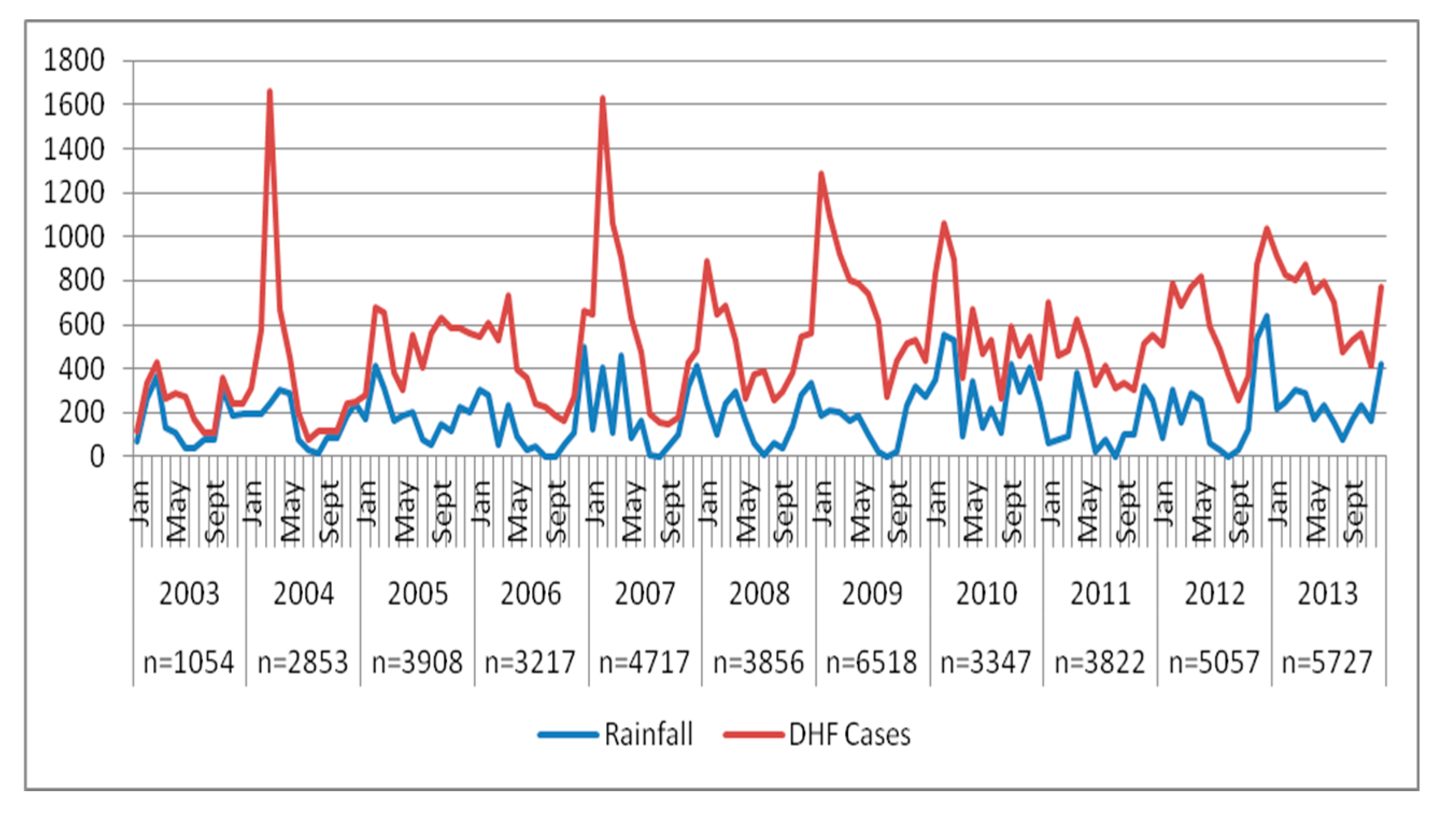
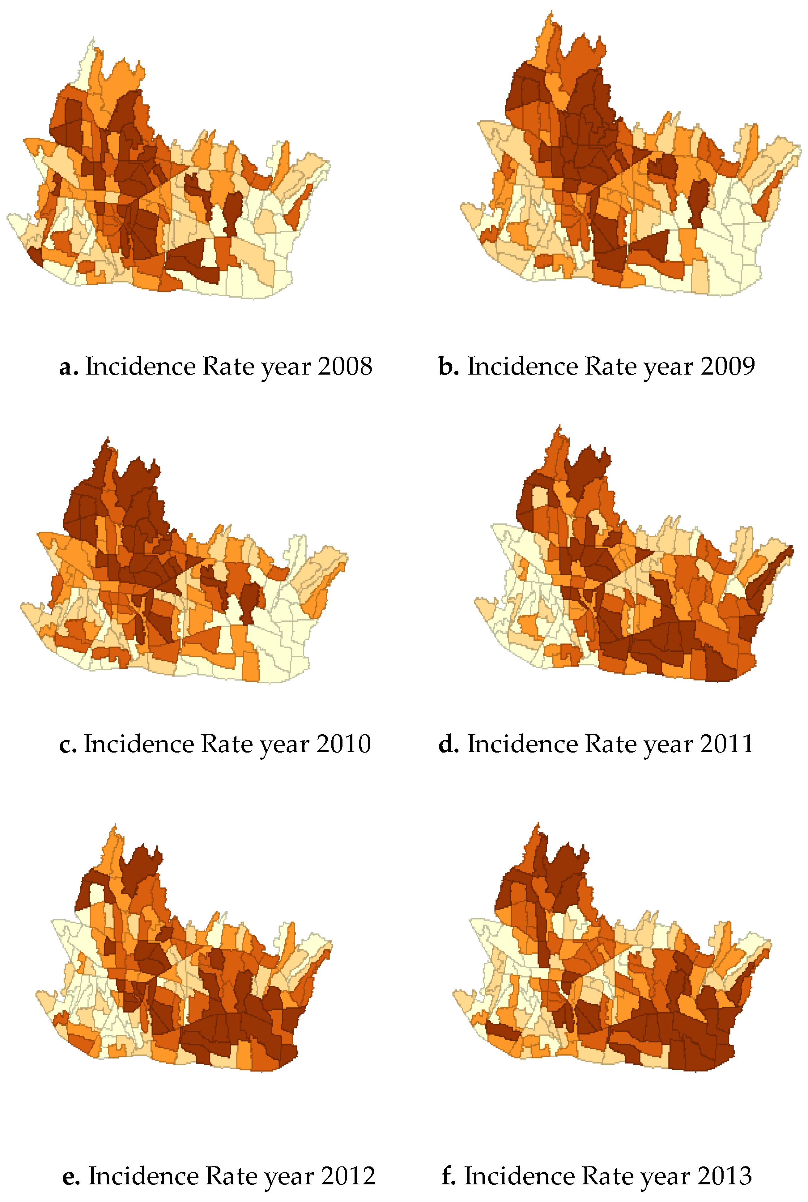
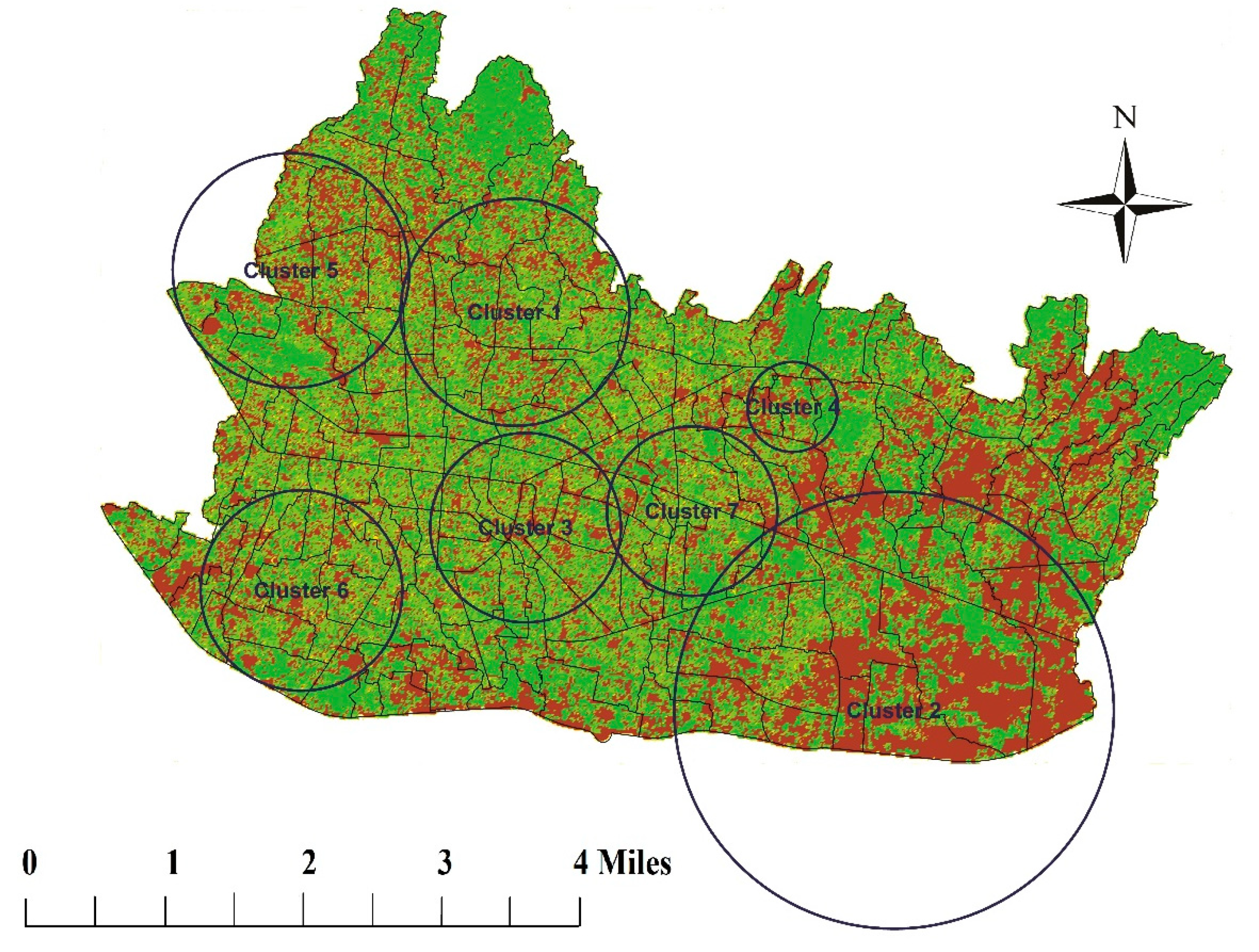
3. Results
4. Discussion
Limitations of the Study
5. Conclusions
Author Contributions
Funding
Acknowledgments
Conflicts of Interest
References
- Guzman, M.G.; Harris, E. Dengue. Lancet 2014, 385, 453–465. [Google Scholar] [CrossRef]
- World Health Organization. Global Strategy for Dengue Prevention and Control 2012–2020; World Health Organization: Geneva, Switzerland, 2012. [Google Scholar]
- Karyanti, M.R.; Uiterwaal, C.S.; Kusriastuti, R.; Hadinegoro, S.R.; Rovers, M.M.; Heesterbeek, H.; Hoes, A.W.; Bruijning-Verhagen, P. The changing incidence of dengue haemorrhagic fever in Indonesia: A 45-year registry-based analysis. BMC Infect. Dis. 2014, 14, 412. [Google Scholar] [CrossRef] [PubMed] [Green Version]
- Bandung City Health Office. Bandung Health Profile Year 2013; Bandung City Health Office: Bandung, Indonesia, 2014. [Google Scholar]
- Porter, K.R.; Beckett, C.G.; Kosasih, H.; Tan, R.I.; Alisjahbana, B.; Rudiman, P.I.; Widjaja, S.; Listiyaningsih, E.; Ma’Roef, C.N.; McArdle, J.L.; et al. Epidemiology of dengue and dengue hemorrhagic fever in a cohort of adults living in Bandung, West Java, Indonesia. Am. J. Trop. Med. Hyg. 2005, 72, 60–66. [Google Scholar] [CrossRef] [PubMed] [Green Version]
- Kosasih, H.; Alisjahbana, B.; Widjaja, S.; Nurhayati de Mast, Q.; Parwati, I.; Blair, P.J.; Burgess, T.H.; van der Ven, A.; Williams, M. The diagnostic and prognostic value of dengue non-structural 1 antigen detection in a hyper-endemic region in Indonesia. PLoS ONE 2013, 8, e80891. [Google Scholar] [CrossRef] [Green Version]
- Eisen, L.; Lozano-Fuentes, S. Use of mapping and spatial and space-time modeling approaches in operational control of Aedes aegypti and dengue. PLoS Negl. Trop. Dis. 2009, 3, e411. [Google Scholar] [CrossRef] [Green Version]
- Koyadun, S.; Butraporn, P.; Kittayapong, P. Ecologic and sociodemographic risk determinants for dengue transmission in urban areas in Thailand. Interdiscip. Perspect. Infect. Dis. 2012. [Google Scholar] [CrossRef]
- Cummings, D.A.T.; Iamsirithaworn, S.; Lessler, J.T.; McDermott, A.; Prasanthong, R.; Nisalak, A.; Jarman, R.G.; Burke, D.S.; Gibbons, R.V. The impact of the demographic transition on dengue in Thailand: Insights from a statistical analysis and mathematical modeling. PLoS Med. 2009, 6, e1000139. [Google Scholar] [CrossRef] [Green Version]
- Thai, K.T.D.; Nishiura, H.; Hoang, P.L.; Tran, N.T.T.; Phan, G.T.; Le, H.Q.; Tran, B.Q.; Van Nguyen, N.; de Vries, P.J. Age-specificity of clinical dengue during primary and secondary infections. PLoS Negl. Trop. Dis. 2011, 5, e1180. [Google Scholar] [CrossRef]
- Rodrigues, M.d.M.; Marques, G.R.A.M.; Serpa, L.L.N.; Arduino, M.d.B.; Voltolini, J.C.; Barbosa, G.L.; Andrade, V.R.; de Lima, V.L.C. Density of Aedes aegypti and Aedes albopictus and its association with number of residents and meteorological variables in the home environment of dengue endemic area, São Paulo, Brazil. Parasites Vectors 2015, 8, 115. [Google Scholar] [CrossRef] [Green Version]
- Scott, T.W.; Takken, W. Feeding strategies of anthropophilic mosquitoes result in increased risk of pathogen transmission. Trends Parasitol. 2012, 28, 114–121. [Google Scholar] [CrossRef]
- Paupy, C.; Delatte, H.; Bagny, L.; Corbel, V.; Fontenille, D. Aedes albopictus, an arbovirus vector: From the darkness to the light. Microbes Infect. 2009, 11, 1177–1185. [Google Scholar] [CrossRef] [PubMed]
- Surendran, S.N.; Kajatheepan, A.; Sanjeefkumar, K.F.; Jude, P.J. Seasonality and insecticide susceptibility of dengue vectors: An ovitrap based survey in a residential area of northern Sri Lanka. Southeast Asian J. Trop. Med. Public Health 2007, 38, 276–282. [Google Scholar] [PubMed]
- Kusriastuti, R.; Sutomo, S. Evolution of dengue prevention and control program in Indonesia. Dengue Bull. 2005, 29, 1–7. [Google Scholar]
- Kraemer, M.U.; Sinka, M.E.; Duda, K.A.; Mylne, A.Q.; Shearer, F.M.; Barker, C.M.; Moore, C.G.; Carvalho, R.G.; Coelho, G.E.; Van Bortel, W.; et al. The global distribution of the arbovirus vectors Aedes aegypti and Ae. albopictus. Elife 2015, 4, e08347. [Google Scholar] [CrossRef] [PubMed]
- Leder, K.; Torresi, J.; Brownstein, J.S.; Wilson, M.E.; Keystone, J.S.; Barnett, E.; Schwartz, E.; Schlagenhauf, P.; Wilder-Smith, A.; Castelli, F.; et al. Travel-associated illness trends and clusters, 2000–2010. Emerg. Infect. Dis. 2013, 19, 1049–1073. [Google Scholar] [CrossRef] [PubMed]
- Soghaier, M.A.; Himatt, S.; Osman, K.E.; Okoued, S.I.; Seidahmed, O.E.; Beatty, M.E.; Elmusharaf, K.; Khogali, J.; Shingrai, N.H.; Elmangory, M.M. Cross-sectional community-based study of the socio-demographic factors associated with the prevalence of dengue in the eastern part of Sudan in 2011. BMC Public Health 2015, 15, 558. [Google Scholar] [CrossRef] [PubMed] [Green Version]
- Toan, D.T.T.; Hu, W.; Thai, P.Q.; Hoat, L.N.; Wright, P.; Martens, P. Hot spot detection and spatio-temporal dispersion of dengue fever in Hanoi, Vietnam. Glob. Health Action 2013, 6. [Google Scholar] [CrossRef] [Green Version]
- Banu, S.; Hu, W.; Guo, Y.; Naish, S.; Tong, S. Dynamic spatiotemporal trends of dengue transmission in the Asia-Pacific region, 1955–2004. PLoS ONE 2014, 9, e89440. [Google Scholar] [CrossRef] [Green Version]
- Lover, A.A.; Buchy, P.; Rachline, A.; Moniboth, D.; Huy, R.; Meng, C.Y.; Leo, Y.S.; Yuvatha, K.; Sophal, U.; Chantha, N.; et al. Spatial epidemiology and climatic predictors of paediatric dengue infections captured via sentinel site surveillance, Phnom Penh Cambodia 2011–2012. BMC Public Health 2014, 14, 658. [Google Scholar] [CrossRef] [Green Version]
- Yoon, I.K.; Getis, A.; Aldstadt, J.; Rothman, A.L.; Tannitisupawong, D.; Koenraadt, C.J.; Fansiri, T.; Jones, J.W.; Morrison, A.C.; Jarman, R.G.; et al. Fine scale spatiotemporal clustering of dengue virus transmission in children and Aedes aegypti in rural Thai villages. PLoS Negl. Trop. Dis. 2012, 6, e1730. [Google Scholar] [CrossRef]
- Troyo, A.; Fuller, D.O.; Calderon-Arguedas, O.; Solano, M.E.; Beier, J.C. Urban structure and dengue fever in Puntarenas, Costa Rica. Singap. J. Trop. Geogr. 2009, 30, 265–282. [Google Scholar] [CrossRef] [PubMed]
- Meza-Ballesta, A.; Gonima, L. The influence of climate and vegetation cover on the occurrence of dengue cases (2001–2010). Revista Salud Publica 2014, 16, 293–306. [Google Scholar]


| Type of Land Use | Area (ha) | |||
|---|---|---|---|---|
| 2008 | 2009 | 2010 | 2011 | |
| Wetlands | 1727 | 1719 | 1474 | 1354 |
| Garden/Wasteland | 763 | 761 | 328 | 650 |
| Farm | 0 | 0 | 475 | 186 |
| Housing, school, industry | 7526 | 7538 | 6042 | 12,739 |
| Office complex/Recreation | 0 | 0 | 1854 | 1219 |
| Pool/pond | 72 | 70 | 70 | 35 |
| Not used | 0 | 0 | 0 | 185 |
| Others | 6641 | 6641 | 6458 | 363 |
© 2020 by the authors. Licensee MDPI, Basel, Switzerland. This article is an open access article distributed under the terms and conditions of the Creative Commons Attribution (CC BY) license (http://creativecommons.org/licenses/by/4.0/).
Share and Cite
Sari, S.Y.I.; Adelwin, Y.; Rinawan, F.R. Land Use Changes and Cluster Identification of Dengue Hemorrhagic Fever Cases in Bandung, Indonesia. Trop. Med. Infect. Dis. 2020, 5, 70. https://0-doi-org.brum.beds.ac.uk/10.3390/tropicalmed5020070
Sari SYI, Adelwin Y, Rinawan FR. Land Use Changes and Cluster Identification of Dengue Hemorrhagic Fever Cases in Bandung, Indonesia. Tropical Medicine and Infectious Disease. 2020; 5(2):70. https://0-doi-org.brum.beds.ac.uk/10.3390/tropicalmed5020070
Chicago/Turabian StyleSari, Sri Yusnita Irda, Yessika Adelwin, and Fedri Ruluwedrata Rinawan. 2020. "Land Use Changes and Cluster Identification of Dengue Hemorrhagic Fever Cases in Bandung, Indonesia" Tropical Medicine and Infectious Disease 5, no. 2: 70. https://0-doi-org.brum.beds.ac.uk/10.3390/tropicalmed5020070