Proceeding Paper

Survey and Representation for Rural Landscape. New Tools for New Strategies: The Example of Campello Sul Clitunno †

Civil Engineering and Environmental Engineering Department, University of Perugia, 06125 Perugia, Italy
*
Author to whom correspondence should be addressed.
Presented at the International and Interdisciplinary Conference IMMAGINI? Image and Imagination between Representation, Communication, Education and Psychology, Brixen, Italy, 27–28 November 2017.
Published: 16 November 2017

Abstract

:
Landscape is born when a place is felt, lived, suffered, owned, when it is perceived, in the etymological sense, for which it is taken what is conveyed by the vision with an aim (per-ceive). The underlying theory is related to its etymological link with vision (theoreo), in the eye investigative value that “measures and recognizes” the link between images and memory. In this article is analyzed the complex link between image and landscape experimenting innovative tools and analysis methodologies.

1. Introduction

1.1. Image and Landscape

The relation between image and landscape is substantial, inherent in the regulatory definition of the European Landscape Convention, which defines it as “that part of the territory perceived by the people who live it”. In the relation between image and place, the theme comes as a part of representation studies field, with the centrality of perception that is related with the role of human images [1] and its ability of interpreting [2] as the foundation post of the report. Landscape, in the extemporaneousness act of seeing [3] (p. 17), correlates the experience [4] and the screening processes of the entity that guarantees [5] orientation (p. 55) in the identification [6] (p. 5). Certainly, forms and colors, in relation with the context, have an impact on emerging figures [7]. Otherwise it prevails neutrality [8] (p. 268). Architecture, the city, the country, are in themselves [9] (p. 37) impartial, aseptic, they do not impact on the eye; but, they have their ability to attract those who are interested in them. Thought connected to vision [10] allows the relation to be. A clear example may be a man driving along the road: he pays attention to a different signal system, it is not possible to say that he is gaining an idea of landscape, with the territory and the environment, which, net of a summary judgment, runs around him. Who sits next to him, with no interest in road language and in the corresponding actions, can activate an interpretation path on the perceived space, implicitly tied to a drawing, also immaterial, however, represented as “a graphic model ... conceptual model, an image purely conventional, of objective reality, able to communicate this reality”[11] (p. 157). Turri says that, for travelers, to perceive is as to fix many perceptions, images or iconema, since travel experience is primarily visual. The iconema, specifies Turri, is an image related to a place, but it is not the place itself; the place is in fact a point in a space, in where many events may have happened. Therefore, a place in where there is a waterfall is expressed by the iconema of a waterfall, while the place where hero died it is not attributable to an iconema, instead it will be the tomb built therein. In fact, the territory’s iconemas arrange themselves harmoniously or not in the context, and that is what we see as essential and figurative elements of the landscape; man does not invent landscape, but he “acts in the landscape from nature”, on availability, according to its dictates in relation with what man asks [12].
In the eye, as main instrument of knowledge, it emerges in this regard the dual role of the image, seen as a product and as a process: as a product because our places are enriched with images that anticipate the vision; as a process because, through perception, territory and environment enter into a relation with the subject and with a forest of images, patterns and categories that influence the interpretation.

1.2. Landscape, Image, Identity, Projection

Landscape is born when a place is felt, lived, suffered, owned, when it is perceived, in the etymological sense for which it is taken what is conveyed by the vision with an aim (per-ceive). The underlying theory is related to its etymological link with vision (theoreo), in the eye investigative value that “measures and recognizes” [13] (p. 54), the link between images and memory [14]. Reading a place precludes an action that limits and searchs for order, geometric interpretation, “the first analytical approach to the experience” [3] (p. 18), in order to correlate vision with scheme [15] (pp. 21–32), appearance with structure, image with form [2], “existing view” with “emerging view”, as well as “existing image” with “revealed image” [16] (pp. 6–7). If more and more all dealing with landscape, is mainly because the image is grasped by all, from multiple points of view, as a function of different and heterogeneous interpretative categories. For the image perceived ordered, it is necessary to identify and communicate types and main figurative structures. In general, the vision passes from unity retail, to understand everything it needs to dwell on figures, “points of maximum significance, the bearers of much of the meaning” [17] (p. 80).
Still, it leads back all to the image, which invites to understand storage and interpretation processes [18], and the need of synthesis requires that the complexity of floors in interpolation spaces [19] (p. 61). In fact, for us “witnesses of an organized sequence” [18] (p. 305), the two-dimensionality of the projected plans [1], mostly vertical, which are juxtaposed in a serial manner in sequences leaves and bring the spatiality, though controlled through schematic of the two-dimensional drawing of the plant [20] (p. 18), “austere abstraction…arid algebrization” [13] (p. 37). According to Kevin Lynch, “the world can be organized around a series of focal points, it can be divided into regions or reconnected trough memorable itineraries” [21] (p. 29). It can be taken as an example any route and it can be considered whether the description that it derives from, it was not born from a geometric order of sequencing of elements of identity in a structure, in the synthesis that finds in (static) points and (dynamics) lines the foundational relations of urban orientation.
Gestalt theory (Figure 1) was the first to study the principles that govern vision and it demonstrated the famous laws of the form (proximity, similarity, common destiny, closed form, good curve, good shape and past experience). This theory also analyzed the relation between figure and background and therefore the importance of the outline in their definition [22].
All these considerations were taken up by the cognitivists, a current of thought that was born with the aim to explain organized, constructive and global aspects of the psychic phenomena that were missing in the contemporary’s rigid analytical-reductive method. The goal of cognitive psychology is to study the mental processes through which the information is acquired, processed, stored and retrieved by the cognitive system. In this context, themes and methods of Gestalt have been taken up and re-read. Given the strong link between brain and computer, it was indeed possible to apply to perception the element of computation, owned by the cognitive approach: brain and eye were therefore treated as a hardware and perception as a software for reprocessing the [23] input.
Another theory of vision that was inspired by the Gestalt, it is J. Gigbson’s ecological approach to perception, his theory is based on the idea that perception can be explained through the analysis of the structure of the environment of an organism (the ecology of the organism) and not through brain mechanisms; the discipline that comes from this assumption was in fact named by Gibson “ecological perspective”, which therefore does not study the biological basis of perception nor the brain, but the environment. The stimulus, which is the optical information provided, according to Gibson is the light, which goes to define the surrounding environment: with Ambient Optic Array (AOA). It goes to define the incident light from all directions toward a given point of observation. When the observer moves, the retinal stimulation spatial pattern is constantly changing over time (optic flow).
The ecological optical tries to define useful information, which are information that a moving observer can use in the environment. Gibson believed that the information obtainable by the stimulation of the retina would lead to an organization, to actively explore the environment and to perceive without ambiguity; however, the brilliant analysis of information obtainable from the dynamic AOA has its limitations in explaining the fundamental uncertainty in the reconstruction of the real world in 3D from the flat 2D retinal information [24].

2. Location: Agriculture Landscape in Italian Case

Landscape, in its materiality, incorporates but also overcomes the meanings and the most romantic projections that are related with fictitious or real identities [25]. Rather, landscape can be stigmatized as man’s outcome from the work on the territory [26] (pp. 417–424). It is work [27], who physically generated the construction of our landscapes [28], by the virtue of the conflictual relation with nature: its beauty, its strength, its grandeur substantiates and certainly it denotes the work, fighting against man, seeking for a relation for man not to overwhelmed it, for this so often it rises, seeking for a point of view, how Petrarch does in his ascent to the Mont Ventoso [29] (pp. 157–158). The history of places tells us about this relation, the conflict between man and nature, where the architecture is born, in Laugier’s aesthetics [30], as an expression of survival instinct. The association of nature with landscape can thus be a drift extremely reductive. Then, without contesting the centrality of an ecological vision that must be the base of the development of the area, it is for survival that areas are reclaimed, land is cultivated and geometry is used as a way to create order, to create images related with reality lived in the anthropized space, also to know and dominate the image of the area. Therein it lies a coincidence of legislation codification of the identity found in the Constitution of our Republic, “founded on work” (Article 1), and the European Landscape Convention, which defines it as an expression of the diversity of their shared heritage cultural and natural foundation of their identities.
Rural landscape is definable as one of the most coveted, among the present ones in an area since a long time, and which is stabilized or that slowly evolves [31]. According to Birks, the cultural landscape is what is configured as the maximum integration between natural and human-activity environment [32]. It is also clear in this sense the interdisciplinarity: if human action comes in play, it is possible to observe the markets’ space, into which the activity is insert, with its objectives and choices. Those choices derive, as Medici noted, [33] from a productive combination, such as a type of crop, rather than another, in relation with land, which in turn determines the “shape” of landscape. The study applies theories and experiments on the territory of Campello Sul Clitunno which represents, in this sense, a good example of a landscape that, with its shapes and in its images, it conveys man’s action who, over time, has been working on it. In particular, Campello’s landscape is characterized by a predominantly agro-forestry use, where the down-hill zone, which is centered on cultivation of olive trees and it is characterized by the presence of dry stone walls for containment of the tiers, it prevails for morphological uniformity and visual continuity, connoting a landscape image potentially very strong and iconic (Figure 2). The identity associated to this place today derives directly from the mass force played centuries ago to replace forests with olive groves, and the techniques demonstrated the ability of building tiers with drywalls suitable for the cultivation of olive trees on the slopes, and to give to the product of this territory a symbolic and representative value. In architecture and urban planning sectors it is been growing the interest in movies and media based on the representation of landscape in time and history, thus determining the centrality of perception of landscape considered as “moving”.
In the age of communication, the image of landscape is the “face” that “re-veils” its story, the experiences that shaped the character, its essence, culture and identity all reflected in here. This image is often known and conveyed through the “product” of the same landscape, but such knowledge does not necessarily bind to a direct experience, more often it is only an iconic image that strikes, more or less consciously, through media [34] (p. 15) and digital world. At the base, it is given the possibility of reducing the perception of logical space, the reality to investigate. Digital image, created locally and distributed worldwide, allows the emerging of new connections; a variety of digital media and data to generate new forms of knowledge and visualization. Considering landscape products, intended as man’s action that acts in it, they become the vehicle of the same image of landscape. Taking as an example Sagrantino di Montefalco, a product that conveys the image of the landscape that produces it: “Sagrantino hills”.
It becomes then central the representative analysis of these bonds as a means to understand and enhance the two-way relation between landscape and landscape’s product through those images, real or ideal, that characterize it.

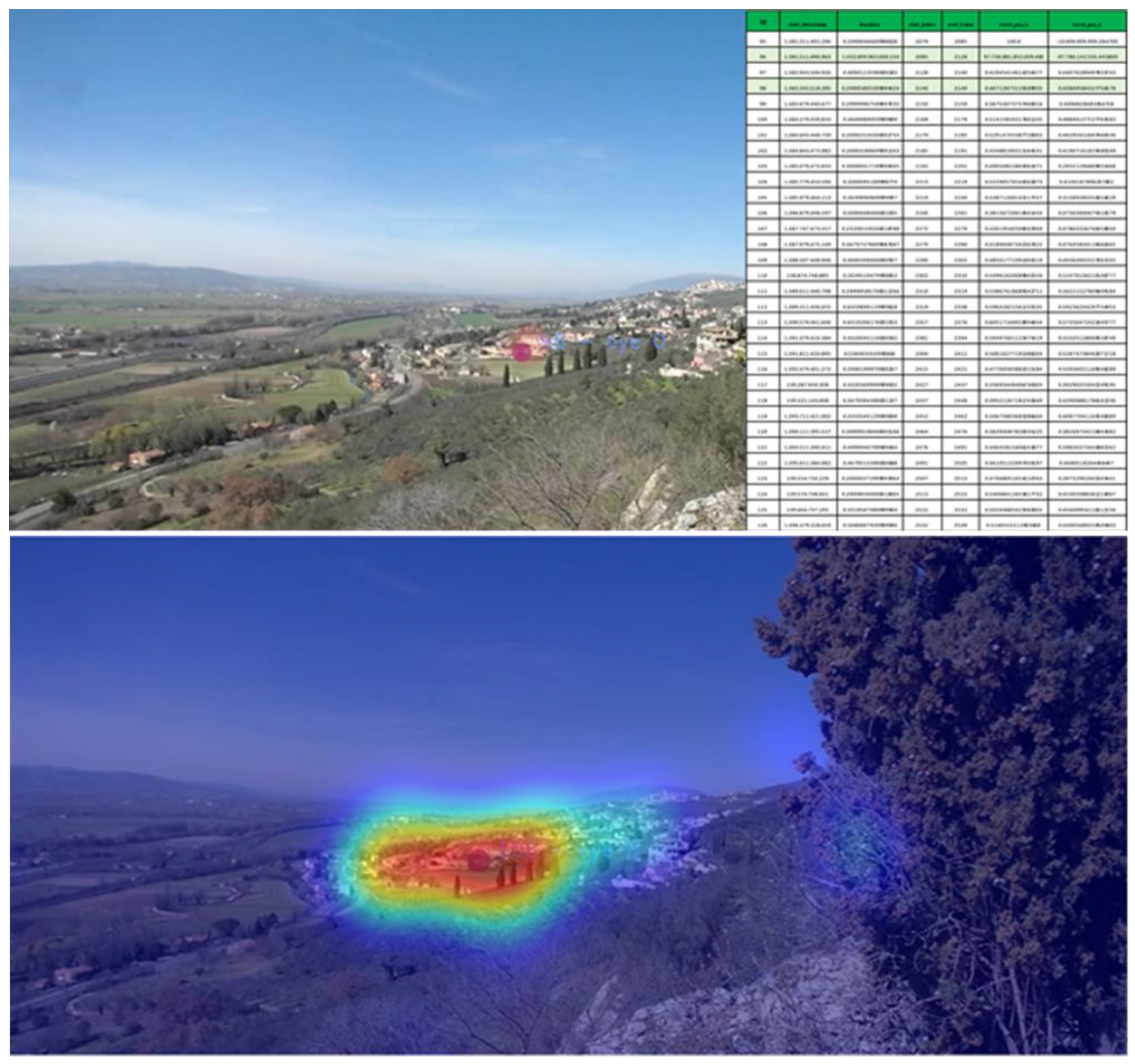
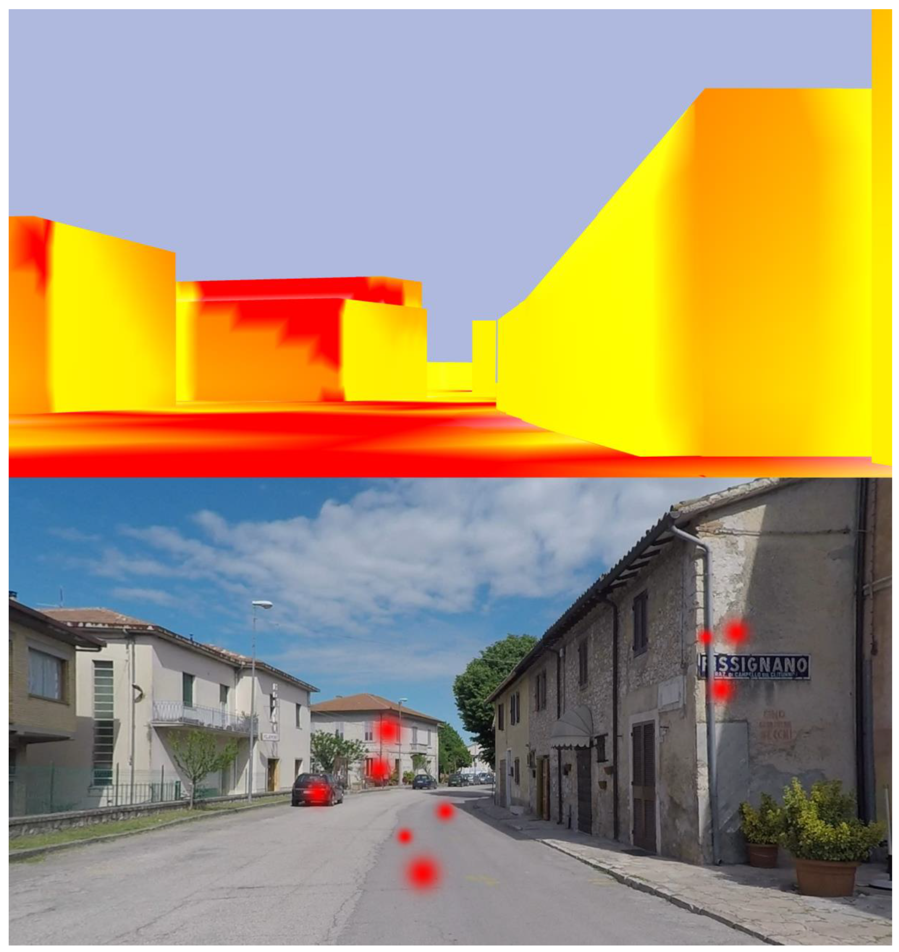
3. Methods and Tools

Appleyard, Lynch, and Myer, in their study “The view from the road”, argued that “the experience of a city is basically a moving vision, and this is the vision that we must understand if we want to reform the aspect of our cities” [35] (p. 63), introducing highway field of aesthetics in the mid 60 s. And it was already clear that this motion picture studies would be used to help the research on landscape. The idea that designers should engage with perception of landscapes on the move has also been favored by the American writer and philosopher J.B. Jackson, who realized the crucial role of mobility and road, particularly in defining national identity of North American landscape. J.B. Jackson’s work highlighted the self-vernacular character of landscape as formed by the interaction of all people and he coined the term “self-vernacular landscape” to describe the culture of road and traffic facilities created around the car. [36] The central image stands as an essential element in the active role that everyone has read and wrote in our places, the duty to feel and to be leaders [37] (pp. 207–223). Landscape, while remaining an aesthetic value, it also acquires “ethic” dimensions when through popular action [38] (p. 14) it shares the value of the Common Good [39]. It is therefore necessary to develop new participatory instruments to investigate these issues and provide the necessary data to understand its evolution.
The specific study researches the tools to define the characters of local landscape of Campello sul Clitunno. In the traditional case study the instrument mainly used for this kind of analysis, is the survey [40,41,42,43]. For the present case, an online survey was drawn up prior to the qualities of Campello’s landscape, it was presented to people that were not from the place, and from the survey it emerged that among all valuable characters there were olive groves, components of the countryside, and villages that surrounded them, elements of the historic landscape. While, among the detractors of the qualities of landscape, most guidance encountered difficulties in crossing the landscape itself for the loss of proximal landmarks.
This lack of perceptual coherence is due to a simple difference in distance of the points of view, it led the study to think about how a landscape, so easy to read in a distance, it appears so confused and not very “perceptible” when located to enter more in touch with it. Certainly, a part of the problem resides in the physical conformation of the place, that with the observer’s approach precludes the view of olive trees side which identifies the location and villages that serve as reference points. However, other factors may contribute to this loss of orientation. To analyze this particular situation an experimentally used tool is the eye tracker.
Eye-tracking is the process of measuring ocular fixation point or the motion of an eye relative to the head used in the anatomical and physiological study of the visual apparatus, in cognitive linguistics and in designing of commercial products. In this study case this approach has been extended to the study of the area, in order to identify any perceptual difficulties.
Such measurements can be obtained through an eye-tracker: specifically, it has been used an eye-tracker Pupil, made of a world camera and an eye camera. (Figure 3).
The first has a sensor of 1910 × 1080 30 fps and an amplitude of the visual field of 90 degrees diagonally, with a latency of 127.7 ms; the eye camera has a sensor of 640 × 480 and 120 fps, with a latency of 5.7 ms; room and lighting are IR, not to disturb the observer since the wavelength IR does not belong to the visible spectrum [44].
The data is recorded through the open source Pupil Capture software that once calibrated, associates the movement of the pupil in the eye chamber to the respective point in the world camera, in doing so it is possible to associate the fixations and/or eye movements to an element present into the surrounding environment.
The recorded data is then processed through another open source software, Pupil Player, where it is possible to export a video with the areas with a greater determination or an heat map, which shows a graphical representation of where, in a time interval, the gaze lingers longer.
The data collection experience with the use of the eye tracker was carried out in two different cases, with a direct observation of landscape and through a recording.
The use of the instrument in the first case:
  • PHASE 0—Preliminary Test
The preparatory phase to the actual testing involves a series of preliminary tests, among which the correct settings for the calibration of the instrument in the natural environment were identified.
  • STEP 1—Capture
The actual data collection experiences was held in occasion of the meeting on 9 March 2017, The next landscape—Invention or narration? held in Pissignano. After the conference, it was asked to some volunteers to wear the eye tracker and look out from the panoramic terrace of the castle of Pissignano, observing the landscape for about a minute. After the observation, it was asked to answer a few questions about the experience and to participate to a survey on the town of Campello sul Clitunno.
  • STEP 2—Analysis
The collected data in the previous phase were processed in accordance with the purpose of identifying the particular characteristics of the observed landscape, with a particular attention for the elements of value and for the detractors of landscape and the way in which they were perceived by the observer. The eye tracker allowed us to know the points on which the eye focuses more regardless to the viewer’s will, considering unconscious perception.
By using the software Pupil_Player it was possible to conduct analysis on different videos collected during the capture phase. Firstly, a different fixation setting was tested to filter out unnecessary results: human eye continuously performs fixations, but some of those are so fast that the brain processes even if they do not exceed to a certain value. It was therefore decided to adjust the analysis with the plugin Pupil Dispersion Angle Fixation Detector 3D, so that it could highlight only the points in which the viewer’s gaze was fixed for at least 0:45 s with a maximum scattering angle of 2.5°. This plugin allowed not only to identify graphical points on individual frames of the video played by the front camera, but also to export from a table software to identifies the points in the plane as a function of time, considering how the vertical plane is associated with the field of vision of the front camera coordinated and how long the length of the video is.
Considering short intervals of the video (maximum 5 s), between them corresponding to observed objects (panoramic view towards Assisi), it is possible to superimpose different results using the plugin Offline Surface Tracker. This plugin recognizes a surface through the marker (automatic or manually set) and analyzes the observer fixations by generating a Heat Map, a map of heat, on which it identifies the most observed areas (Figure 4).
  • PHASE 3—Results
Immediately after the observation it was asked to the participants what they thought about what they observed; almost all of them answered that they watched Assisi in the distance. This information coincides with the extracted data with HeatMap and PupilAngleDispersion FixationDetector3D, however most of the recordings were insisting on a particular area of the observed territory, except those directly focused on Assisi: a real detractor that continuously distracted the eye. This element corresponds to a lotting of decontextualized buildings from the surrounding environment for both colors and building type, capturing the unknowingly observer (Figure 5). From here it was stressed how useful the analysis and the perceptual study are, in order to implement mitigation strategies of these problems and to define targeted limitation rules.
Another important result is that none of the participants in the trial had fixed his eyes on the Clitunno Temple (UNESCO heritage asset), which remained completely ignored because of the lack of recognition. In the second case the observers were asked to watch a video of the route of the former SS3 Flaminia crossing Campellino’s territory from south to north. With this experiment, it was observed that the major problem is represented by signs (Figure 6) that, for the detected quantity, are the real disturbing elements. Also, from North, a strong negative impact is the airline that disfigures the olive trees hill below Pissignano’s Castel—even more serious from the Castle (Figure 6), in which the electric line is a high impact element for an asset subjected to landscape bond. Finally, the massive wall and obsolete road gate just ahead attract attention at the expense of the Temple on the Clitunno that remains completely indistinguishable (Figure 6).
The design inspiration that derives from these studies, it suggests to act on the signage, thinking on a plan that will limit its use and a typology to better contextualize the territory and its products. Also, it becomes interesting and a functional potential the study of an orientation plan that leverages this technology to identify new strategies that enhance the audibility of a punctual assets of the territory in an alternative or supplementary way to the signage.

Comparison

Recent studies applying the theories of biometrics, (perception of space) developed with the typical tools of today’s representation, such as Rhinoceros and Grasshopper, are able to analyze, using algorithms the audibility, in terms of visual cones, three-dimensional models whose results are comparable with those of Eye Tracking [45].
After reconstructing in digital space experience the same conditions of the eye tracking (model, route, speed) it was applied the algorithmic analysis. The results of this study confirm that the two types of surveys are comparable, both experiences identify the same areas of visual field in which the eye is attracted, as shown by the images. (Figure 7).
It becomes possible with these tools to study the landscape not only as it is perceived today, but also evaluate it and catalog it with comparable data and then create a new “Image” from a scientific criteria. Based also on an approach of parametric nature, such means can also be used for the study of new elements to be included in the territory, or to assess how it will globally change the perception if it is enriched by new elements acting for both protection and modification of the landscape.

4. Conclusions and Further Research Developments

The main theme of the research is the analysis of the relation between perception and landscape, methodologies and tools, in order to investigate this issue. The obtained results showed the need of deepen the use of these representative technologies applied to landscape, because they draw landscape by detecting or by designing, it means to give order to the experiences, expressing identified connections, indicating the meanings, understanding the reflected identity demonstrated in places. Understanding the mechanisms inherent to the sequence of images [46] (p. 148) enables, it is possible to perceive reality not as “units instantly created, but as processes in progress, tireless transformations of spatial configurations” [34] (p. 209). In this context, Franco Purini writes that aspiration “is built through cross-fades of mental images arising from archiving of previous retinal images on which the will to form new work groups and radical transformations; these images are not more than drawings” [47] (p. 341). Landscape thus becomes a representative act of human communication, an instrument attributable to the plane of speech [48] (pp. 31–45): The construction itself of the idea of landscape [49] is configured through a language that has an eminently narrative nature and a semantic structure of the speech based on the images.

Author Contributions

The introduction paragraph at the point 1.1 was drawn up by Marco Filippucci, the point 1.2 by Marco Seccaroni, the second was by Michela Meschini and the third by Elisa Bettollini. The last paragraph was drawn up by Fabio Bianconi.

Conflicts of Interest

“The authors declare no conflict of interest.”

References

  1. Gregory, R.L. Occhio e Cervello. La Psicologia del Vedere; Cortina Raffaello: Milano, Italy, 1998; ISBN 8870781798. [Google Scholar]
  2. Filippucci, M. Dalla Forma Urbana All’immagine Della Città. Percezione e Figurazione All’origine Dello Spazio Costruito. Ph.D. Thesis, Scienze della Rappresentazione e del rilievo, La Sapienza, Roma, 2012. [Google Scholar]
  3. Gioseffi, D. Rappresentazione geometrica dello spazio. In I Fondamenti Scientifici Della Rappresentazione; Dipartimento di Rappresentazione e Rilievo, Università Degli Studi di Roma La Sapienza: Rome, Italy, Unione Italiana per il Disegno, Arte della Stampa, Roma; 1989; p. 17. [Google Scholar]
  4. Pierce, C.S. Esperienza e Percezione. Percorsi Nella Fenomenologia; Luisi, M., Ed.; ETS: Pisa, Italy, 2011; ISBN 978-884672072-6. [Google Scholar]
  5. Klee, P. Teoria Della Forma e Della Figurazione; Feltrinelli: Milano, Italy, 1984; p. 55. ISBN 8807200015. [Google Scholar]
  6. Norberg-Schulz, C. Genius Loci: Paesaggio Ambiente Architettura; Electa Mondadori: Milano, Italy, 1979; p. 5. ISBN 9788843542635. [Google Scholar]
  7. Podzemskaia, N. Colore Simbolo Immagine. Origine della Teoria di Kandinsky; Alinea: Florence, Italy, 2000; EAN 9788881254354. [Google Scholar]
  8. Norberg-Schulz, C. Il Significato in Architettura; Jencks, C. , Braid, G., Eds.; Dedalo: Bari, Italy, 1974; p. 268. ISBN 9788822004048. [Google Scholar]
  9. Choay, F. Urbanistica e semiologia. In Il Significato in Architettura; Jencks, C., Braid, G., Eds.; Dedalo: Bari, Italy, 1974; p. 37. ISBN 9788822004048. [Google Scholar]
  10. Arnheim, R. Il Pensiero Visivo; Einaudi: Torino, Italy, 1974; ISBN 9788806344054. [Google Scholar]
  11. Cardone, V. Modelli Grafici e Modelli Geometrici. In Proiezione e Immagine. La logica della Rappresentazione; Dell’Aquila, M., De Rosa, A., Eds.; Arte Tipografica, Napoli; 2000; p. 157. [Google Scholar]
  12. Turri, E. Il Paesaggio e il Silenzio; Marsilio: Venezia, Italy, 2010; ISBN 9788831784139. [Google Scholar]
  13. Le Corbusier. Verso una Architettura; Cerri, P., Nicolin, P., Eds.; Longanesi: Milano, Italy, 1989; p. 54. ISBN 9788830406148. [Google Scholar]
  14. Husserl, E. Esperienza e Giudizio. Ricerche Sulla Genealogia della Logica; Bontempi: Milano, Italy, 1995; ISBN 9788849281248. [Google Scholar]
  15. Ugo, V.; Schema. XY, Dimensioni del Disegno; Cedis editrice: Roma, Italy, 1987; Volume 3, pp. 21–32. [Google Scholar]
  16. Cullen, G. Townscape. Paesaggio Urbano. Morfologia e Progettazione; Calderini Editore: Bologna, Italy, 1976; pp. 6–7. [Google Scholar]
  17. Arnheim, R. Arte e Percezione Visiva; Feltrinelli: Milano, Italy, 2008; p. 80. ISBN 9788807100239. [Google Scholar]
  18. Filippucci, M.; Feyles, M. Scrittura/Disegno. Riduzione, Tecnica, Interpretazione. In Trascrizioni. Idee per la Rappresentazione; Artegrafica: Roma, Italy, 2012. [Google Scholar]
  19. Bedoni, C. Realtà e Immagine Mentale: Costanza Formale e Dimensionale Nella Memoria Dell’architettura. In I Fondamenti Scientifici della Rappresentazione; Dipartimento di Rappresentazione e Rilievo, Università Degli Studi di Roma La Sapienza: Rome, Italy, Unione Italiana per il Disegno, Arte della Stampa, Roma; 1989; p. 61. [Google Scholar]
  20. De Rubertis, R. Disegno dell’Architettura; NIS: Roma, Italy, 1994; p. 18, EAN 9788843025176. [Google Scholar]
  21. Lynch, K. L’immagine della Città; Marsilio: Venezia, Italy, 1985; p. 29, EAN 9788831772679. [Google Scholar]
  22. Wertheimer, M. Experimentelle Studien über das Sehen von Bewegung. In Zeitschrift für Psychologie und Physiologie der Sinnesorgane; Barth, J.A., Ed.; Lipsia, Germany, 1912. [Google Scholar]
  23. Dörrienstraße 16.
  24. Neisser, U. Cognitive Psychology; Appleton-Century-Crofts: New York, USA, 1967. [Google Scholar]
  25. Palmer, S.E. Vision Science Photons to Phenomenology; MIT Press: Cambridge, MA, USA, 1999. [Google Scholar]
  26. Birrini, M. Contro le Radici. Tradizione, Identità. Memoria; il Mulino: Bologna, Italy, 2012; ISBN 9788815234650. [Google Scholar]
  27. Bianconi, F.; Filippucci, M. Lavoro e paesaggio. Catalogazione e analisi dei beni rurali di Castiglione del Lago (PG). In Le Vie dei Mercanti. Med Townscape and Heritage: Knowledge Factory; Gambardella, C., Ed.; Atti del Ottavo Forum Internazionale di Studio; Napoli-Capri 3–5 giugno 2010; Gambardella, C., Ed.; La scuola di Pitagora: Napoli, Italy, 2011; pp. 417–424. [Google Scholar]
  28. Frampton, K. Labour, Work and Architecture; Phaidon: London, UK, 2002. [Google Scholar]
  29. Bianconi, F. Tracciati delle Modernità; Viaeindustriae: Foligno, Italy, 2011; ISBN 9788890345999. [Google Scholar]
  30. Petrarca, F. Ascesa al Monte Ventoso, in Familiares, IV, 1, 26 aprile 1336. In Petrarca: Profilo e Antologia Critica; Chines, L., Guerra, M., Eds.; Bruno Mondadori: Milano, Italy, 2005; pp. 157–158. [Google Scholar]
  31. Laugier, M.A. Essai sur L’architecture; Chez Duchesne: Paris, France, 1753. [Google Scholar]
  32. Marino, D.; Cavallo, A. Il paesaggio agrario tradizionale. Riflessioni per un inquadramento metodologico per l’analisi e la catalogazione. Agriregionieuropa 2009, 5, 19. [Google Scholar]
  33. Birks, H. (Ed.) The Cultural Landscape: Past, Present and Future; Cambridge University Press: Cambridge, UK, 1988. [Google Scholar]
  34. Medici, G. I Tipi di Impresa Nell’agricoltura Italiana; Inea: Roma, Italy, 1951. [Google Scholar]
  35. Kepes, G. Il Linguaggio della Visione; Dedalo: Bari, Italy, 1971; p. 15. ISBN 9788822004024. [Google Scholar]
  36. Appleyard, D.; Lynch, K.; Myer, J.R. (Eds.) The View from the Road; The MIT Press: Cambridge, MA, USA, 1964; p. 63. [Google Scholar]
  37. Jackson, J.B. Discovering the Vernacular Landscape; Yale University Press: New Haven/London, UK, 1984. [Google Scholar]
  38. Linehan, J.R.; Meir, G. Back to the Future, Back to Basics: The Social Ecology of Landscapes and the Future of Landscape Planning. Landsc. Urban Plan. 1998, 42, 207–223. [Google Scholar] [CrossRef]
  39. Settis, S. Azione Popolare. Cittadini per il Bene Comune; Einaudi: Torino, Italy, 2012; p. 14. ISBN 9788806212933. [Google Scholar]
  40. Mattei, U. Il Benicomunismo e i Suoi Nemici; Einaudi: Torino, Italy, 2015; ISBN 9788806218614. [Google Scholar]
  41. Colléony, A.; Prévot, A.C.; Saint Jalme, M.; Clayton, S. What kind of landscape management can counteract the extinction of experience? Landsc. Urban Plan. 2017, 159, 23–31. [Google Scholar] [CrossRef]
  42. Raymond, C.M.; Gottwald, S.; Kuoppa, J.; Kyttä, M. Integrating multiple elements of environmental justice into urban blue space planning using public participation geographic information systems. Landsc. Urban Plan. 2016, 153, 198–208. [Google Scholar] [CrossRef]
  43. Garrido, P.; Elbakidze, M.; Angelstam, P. Stakeholders’ perceptions on ecosystem services in Östergötland’s (Sweden) threatened oak wood-pasture landscapes. Landsc. Urban Plan. 2017, 158, 96–104. [Google Scholar] [CrossRef]
  44. Anderson, N.M.; Ford, R.M.; Williams, K.J.H. Contested beliefs about land-use are associated with divergent representations of a rural landscape as place. Landsc. Urban Plan. 2017, 157, 75–89. [Google Scholar] [CrossRef]
  45. Pupil Labs. Available online: https://docs.pupil-labs.com (accessed on 8 September 2017).
  46. Seccaroni, M. Rappresentazione delle Relazioni Immateriali. Sperimentazioni Percettive Attraverso Algoritmi Parametrici per il Progetto di Paesaggio. Bachelor’s Thesis, Università degli Studi di Perugia, Perugia, Italy, 2015/2016. [Google Scholar]
  47. Arnheim, R. Dinamica della Forma Architettonica; Feltrinelli: Milano, Italy, 1985; p. 148. ISBN 9788807100574. [Google Scholar]
  48. Purini, F. Dodici Frammenti per Disegnare il Disegno … Lettera Romana a Margherita De Simone, in Palermo: Le parole e i segni, La Collana di Pietra, 2, 1982, rip. In Dal Progetto. Scritti Teorici di Franco Purini; Moschini, F., Neri, G., Eds.; Kappa: Roma, Italy, 1992; p. 341. ISBN 9788878900592. [Google Scholar]
  49. Chiera, A.; Adornetti, I.; Nicchiarelli, S.; Ferretti, F. Linguaggio, Tempo e Narrazione. In Soglie del Linguaggio. Corpo, Mondi, Società; Bertollini, A., Finelli, R., Eds.; RomaTre Press: Roma, Italy, 2017; pp. 31–45. ISBN 978-88-94885-19-4. [Google Scholar]
  50. Rykwert, J. L’idea di Città: Antropologia della Forma Urbana nel Mondo Antico; Scattone, G., Ed.; Adelphi: Milano, Italy, 2002; EAN 9788845917202. [Google Scholar]
Figure 1. GESTALT’s manifest.
Proceedings 01 00934 g001
Figure 2. Olive trees band and down-hills Assisi-Spoleto with dry stone walls, in the territory of Campello sul Clitunno. Michela Meschini.
Proceedings 01 00934 g002
Figure 3. Pupil Pupil Head Set and software.
Proceedings 01 00934 g003
Figure 4. Pupil results Player and Heat Map.
Proceedings 01 00934 g004
Figure 5. Landscape visual detractor.
Proceedings 01 00934 g005
Figure 6. Landscape visual detractor.
Proceedings 01 00934 g006
Figure 7. Comparison of the two methods of analysis.
Proceedings 01 00934 g007
Publisher’s Note: MDPI stays neutral with regard to jurisdictional claims in published maps and institutional affiliations.

