Review

Going Batty: The Challenges and Opportunities of Using Drones to Monitor the Behaviour and Habitat Use of Rays

1
Marine Ecology Group, Department of Biological Sciences, Macquarie University, Sydney, NSW 2109, Australia
2
School of Environmental and Life Sciences, University of Newcastle, Callaghan, NSW 2258, Australia
3
College of Science & Engineering/TropWATER, James Cook University, Nguma-Bada Campus, 14-88 McGregor Road, Townsville, QLD 4878, Australia
*
Author to whom correspondence should be addressed.
Submission received: 11 December 2020 / Revised: 29 January 2021 / Accepted: 29 January 2021 / Published: 2 February 2021
(This article belongs to the Special Issue Drone Technology for Wildlife and Human Management)

Abstract

:
The way an animal behaves in its habitat provides insight into its ecological role. As such, collecting robust, accurate datasets in a time-efficient manner is an ever-present pressure for the field of behavioural ecology. Faced with the shortcomings and physical limitations of traditional ground-based data collection techniques, particularly in marine studies, drones offer a low-cost and efficient approach for collecting data in a range of coastal environments. Despite drones being widely used to monitor a range of marine animals, they currently remain underutilised in ray research. The innovative application of drones in environmental and ecological studies has presented novel opportunities in animal observation and habitat assessment, although this emerging field faces substantial challenges. As we consider the possibility to monitor rays using drones, we face challenges related to local aviation regulations, the weather and environment, as well as sensor and platform limitations. Promising solutions continue to be developed, however, growing the potential for drone-based monitoring of behaviour and habitat use of rays. While the barriers to enter this field may appear daunting for researchers with little experience with drones, the technology is becoming increasingly accessible, helping ray researchers obtain a wide range of highly useful data.

1. Introduction

Drones are increasingly used as a tool in environmental monitoring and ecological studies to improve traditional methods of data collection. In shallow aquatic environments, drones enable the collection of high-resolution behavioural data of animals with minimal disturbance. Understanding an animal’s behaviour and habitat use provides insight into their ecological role, underpinning effective wildlife conservation and management practices [1,2,3,4].
Rays (Batoidea: Chondricthyes) use a range of coastal ecosystems for food [5], social interactions [6] and reproduction [7]. These ecosystems are also some of the most impacted by humans, and collecting movement and behaviour data within these ecosystems will help with selecting effective management decisions [8,9]. While costly tagging and animal-borne video continue to be used to monitor the long-term migratory movements of rays along coastlines [10,11,12,13,14,15,16], drones represent an effective solution for monitoring fine-scale movement and behaviour in a cost-efficient, minimally invasive manner. While a handful of studies have incidentally documented the abundance of rays with drones (Table 1), there have only been two studies that have used drones to investigate ray behaviour specifically [17,18]. In contrast, shark behaviours have been extensively examined with drones in similar environments [19], and while drone-specific operational protocols exist for sharks [20], none are available for rays. The focus on sharks is concerning since rays are typically under greater extinction risk [21].
Understanding ray behaviour without the context of the environment in which the behaviours are occurring would make it difficult to explain any patterns identified. To assess or map local coastal environments, scientists and managers have used a combination of remote sensing (aerial and satellite imagery), as well as field surveys for decades [30]. Recent developments in drones afford researchers a level of data acquisition autonomy not previously available, providing image data with a spatial resolution an order of magnitude higher than commercial satellites [31,32,33,34].
This review outlines the use of drones, primarily rotary drones, in monitoring the behaviour and habitat use of rays, evaluating opportunities for innovative applications of drones and future directions for ray ecology research. We consider the opportunities and challenges for ray research using drones, focusing on drones as a tool to monitor short-term and fine-scale ray behaviour, and as a mapping tool for habitat assessment. We then discuss some broader issues to consider when using drones for ray research, categorised as regulatory, environment, and technical and operational issues. Finally, we highlight current solutions from a diverse array of studies using drones and propose points of consideration for overcoming these issues.

2. Opportunities for Ray Research Using Drones

Despite the widespread use of drones to observe a range of other marine animals [20,35,36], their application for ray research remains vastly underexplored. In particular, there are opportunities to utilise drones in the monitoring of short-term ray behaviour, and as a mapping tool to assess ray habitat use.

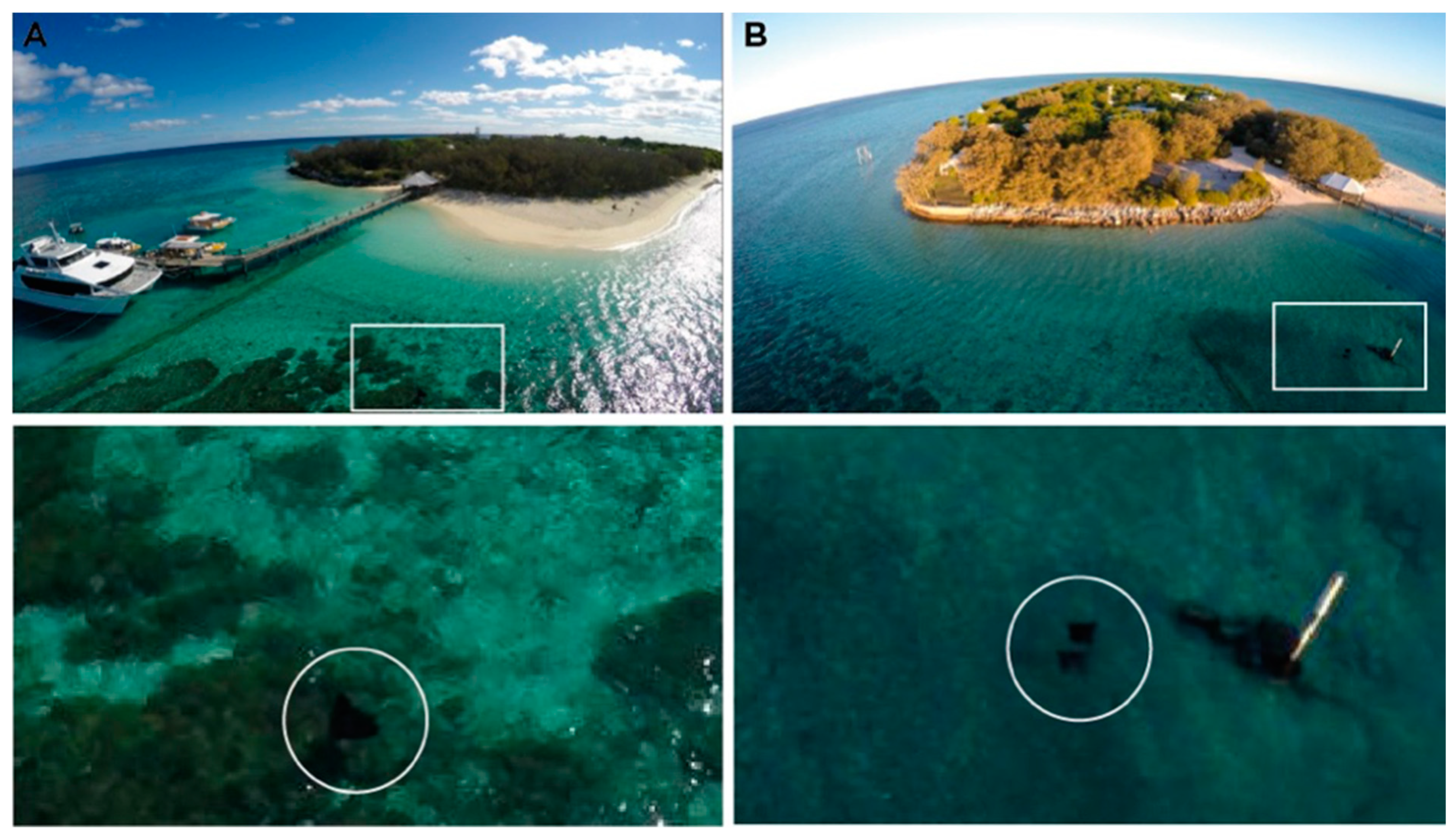
2.1. Drones as a Tool to Monitor Ray Behaviour

Drones are a useful tool to observe rays from an aerial vantage point while having minimal impact on their natural behaviours, contributing to results that better reflect natural patterns [37]. Using drones, studies have performed high-resolution tracking of a range of aquatic vertebrates including elasmobranchs, obtaining information on fine-scale movement and behaviour [38,39]. For example, short-tail stingrays (Bathytoshia brevicaudata) were tracked in a coastal estuary, providing insight into the role that body size, tide and time of day had on their fine-scale movement, all of which had a significant impact on the speed and/or sinuosity of their swim trajectories [18]. Drones can also be used for long-term monitoring of animal populations via photo identification [40], and subsequent analyses such as morphometric data can be automated [41,42]. The capabilities of drones in observing fine-scale ray movement and schooling as well as more opportunistic behaviours, such as natural feeding events, have been demonstrated [17,18,26]. Opportunities exist to innovatively utilise these capabilities in a variety of contexts within ray research. The manoeuvrability and aerial footage captured by drones is particularly well suited to monitoring ray schooling behaviour. Following fevers (schools of rays) for extended periods of time may provide insight into the fluidity of fever shape and size, as well as more focused analysis of the conspecific interactions and social implications between individuals within the fever. There is also potential to combine drone monitoring with more traditional tagging methods to provide behavioural information at different temporal and spatial scales, also enabling visual confirmation of behaviours measured using the tags.

2.2. Drones as a Mapping Tool

The capacity to map and monitor coastal areas is important in assessing the habitat use of rays and the influence of abiotic factors on their movement. Drones are well adapted to provide high level detailed mapping and tracks for typically shallow and inaccessible ray habitats, or those highly complex in structure (Figure 1). Drones allow for time-series monitoring as large as kilometre scales and as fine as decimetre scales [32,41]. These resolutions are crucial to understand the habitat dynamics of many coastal environments. Using drones to produce fine scale maps of fish nursery grounds shows potential to improve the management and assessment of coastal nursery areas also used by rays [43]. Data collected using drones have helped establish the upper limits of seagrass meadows [44], important in detecting areas impacted by anthropogenic impacts as well as implementing efforts to restore the meadows [45], representing crucial habitat for many ray species. Furthermore, combined with photogrammetry techniques, photographs obtained with consumer-grade drones can be used for high-resolution mapping of complex habitats utilised by rays such as shallow-water coral reefs [33,46,47]. They have also been used to count other benthic animals inhabiting those reefs [48], and to obtain new health metrics like volumetric change in oyster reefs [49], with oysters being an important food source for many rays [50]. Thermal imaging from drones has been used to map water temperature heterogeneity across aquatic ecosystems [51,52]. As ray movement may be influenced by water temperature [53], this is particularly relevant to ray research. Drones present an opportunity to map the coastal habitats where many rays occur, providing greater insight into the factors underlying their habitat use and understanding the environmental dynamics influencing their movement within the ecosystem.

3. Current Challenges for Ray Research Using Drones

In recent years, drone technology has improved dramatically and is increasingly accessible to researchers, resulting in the innovative application of drones across many marine systems. Commercial manufacturers are developing new low-cost products for off-the-shelf purchase that are suitable for application within ecological and environmental studies. Despite these advances, there remain some challenges associated with monitoring natural ray behaviour and mapping habitats using drones. These challenges are discussed below.

3.1. Challenges with Monitoring Natural Ray Behaviour Using Drones

Debate in the literature exists regarding potential impacts of drones on natural behaviours of animals, with the intensity of impact proposed to differ between species. It is widely documented that even the most minor human disturbance has the potential to induce behavioural responses in animals [54,55]. While drones aim to reduce many of the impacts associated with human observers, there remains the effect of drones themselves on animal behaviour, however, this is primarily documented in the terrestrial environment. Monkeys, kangaroos and birds exhibit explicit behavioural responses to drones such as unique vocal cues and altered movement patterns [37,56,57], while bears showed limited behavioural responses but significant physiological responses [58], indicating the importance of assessing all stress indicators. Alternate drone configurations (e.g., multirotor, fixed-wing) and the size of the aircraft may also impact animals differently according to their altered flight paths, their likeness to threatening stimuli (e.g., similar shadow to a predator) and the amount of noise they produce [35]. For example, multirotor drones can fly within 40 m of waterfowl without disturbing their behaviour while fixed-wing models need to remain above 60 m altitude to maintain minimal disturbance [59]. Fully aquatic animals are the least affected animals with suggestions that there is some protection provided to the animals via the water layer above [60]. However, changes in behaviour of reptiles and marine mammals have been reported [61,62,63]. This indicates that drone observation may not be appropriate for some species, though in most cases the flight protocol can be adapted to ensure minimal disturbance.
Using drones to infer behaviour in marine animals presents some unique challenges. Drone operations cannot usually be conducted during rough weather conditions or at night time, limiting observations to day time during fair weather. Furthermore, drone observations are generally restricted to rays that occupy shallow marine habitats or stay relatively close to the surface for extended periods of time, limiting the observation of ray movement and behaviour to those that occur within these shallow habitats. For many ray species, this represents only a small proportion of their range, with species such as the short-tail stingray (Bathytoshia brevicaudata) known to descend to depths of 480 m. As such, rays may only be visible at a given location during different tides or during associated weather conditions, no longer being visible at other times when water visibility may have changed [64], or when they have left these shallow habitats. This leads to confusion between inferring lower detection due to altered behaviours during periods of poorer water visibility, or simply greater difficulty in locating animals and identifying individuals during these periods [28]. Several studies studying sharks using drones and other aerial surveillance techniques have indicated that detection reliability decreases beyond approximately 3.5–5 m in depth [65,66,67], likely to be similar for rays. Further considerations are introduced by rays that form densely packed aggregations or fevers that often have several layers of animals, making it difficult to observe an individual for an extended period of time when relying on live field-based detection.

3.2. Overcoming Challenges in Monitoring Natural Ray Behaviour Using Drones

It is difficult to remove any potential for drone systems to impact the behaviour of animals, though the impact for many marine animals can be minimised through altered flight protocols and equipment [20]. When compared with the alternatives such as manned aircraft, stationary videos such as remote underwater video or in-situ observations on scuba or snorkel, the impacts of drones on rays are most likely substantially reduced relative to the impacts of these other modes. By considering the sensitivity of the study species to the potential impacts of drones and making appropriate adjustments, drones can provide unprecedented access and facilitate observations of a greater range of natural ray behaviours. While further species-specific research is important to assess the potential impacts of drones on animal behaviour, there is evidence that the underwater noise effects of drones, particularly for small, electric drones [68], are minimal for subsurface animals [60]. Recommendations on approach distances, appropriate flight altitudes and adjustment periods to reduce behavioural inconsistencies will allow standard operating procedures to be developed for drone observation of rays. Oleksyn et al. (2021) [18] used approach distances ranging from 5 to 25 m above the water level while monitoring large coastal stingrays (Bathytoshia brevicaudata) and observed no obvious behavioural alterations in movement speed and sinuosity. Raoult et al. (2018) [38] tracked a range of mesopredator shark species in a more complex coral reef lagoon using a flight altitude of just 2–3 m, yet similarly reported no behavioural impacts of the drone on their swim trajectory. These findings indicate that approach distance is unlikely to cause observable behavioural changes, suggesting that the flight altitude should be dictated by the size of the target species, complexity of the habitat and the potential for obstacles to impede the flight path at different altitudes when monitoring rays.
Recent developments in drone technology further limit the potential for drones to impact ray behaviour. For example, using drone models with zoom capabilities (e.g., Mavic 2 Zoom with 2X zoom lens) allows drones to fly at higher altitudes above the rays, and increasing the efficiency of the multirotors will reduce the risk of noise pollution disrupting ray behaviour. Continuing to publish protocols for studying rays can also provide effective solutions and problem-solving skills to ray researchers using drones as some species may be more sensitive to drone impacts. Blimps have also been successfully to observe ray movement within coastal ecosystems and represent a viable alternative, particularly for species showing sensitivity to drone impacts [69].
It is important that drone studies do not overstate their findings, given that observations are limited to the portion of the rays’ range within shallow habitats. Detection reliability is likely to decrease in habitats exceeding depths of 5 m [28,65,66,67]. This depth recommendation is subject to change as a result of water quality, weather conditions and the complexity of the substrate, where low-contrast highly complex substrates will make detection more difficult (Figure 2). A polarised lens can also be used to reduce the effects of glare on the surface of the water [38,67] and improve detection in a range of environmental conditions. Simply adjusting the drone orientation to fly with the sun behind it and tilting the camera to off-nadir can also help [70]. However, unless there is excellent water clarity, drone studies will often be restricted to habitats that do not exceed 5 m in depth. To determine the detection depth at different sites, life-size models can be deployed and photographed at different altitudes during a variety of tide heights and weather conditions [18]. Alternatively, experiments will need to include protocols for when rays enter in and out of detection within deeper waters. This may involve a time limit between detections after which the observation is terminated. Pairing tagging or remote operated vehicle (ROV) data with drone data may also provide insight into the behaviours of the rays as they come in and out of vision.

3.3. Challenges with Drone-Based Habitat Mapping

As with traditional aerial survey, drone platforms are used to capture several hundreds of overlapping photos that can later be orthomosaicked into a single image map. The process of structure from motion (SfM) requires high percentages of overlap and sidelap between photos to rectify imagery, and also uses the on-board GNSS (global navigation satellite systems) to place the data in a real-world location [71,72]. The operator typically uses software (often freely available) to predetermine a flight plan to ensure resultant data meet the requirements for SfM.
While the data capture component is now routine, there is a vast difference in data quality that can be achieved, particularly dependent on the environmental conditions at the time. For example, data captured at midday with a solar hotspot in the centre of every image is unusable [32]. Changing the drone’s orientation can be effective in reducing glare off the water, however, planning data collection around these environmental conditions remains as the most effective strategy to produce quality data.
Assuming quality data are captured, unfortunately that does not mean that they will necessarily pass through the SfM orthomosaicking process without incident. These processing algorithms use computer vision to recognise features within each image overlap to tie together [72]. However, such features can be difficult to find in areas of high turbidity, deep water, or uniform substrate types such as sand. Therefore, in the absence of coral bommies, rocks, or other similarly complex habitat features identifiable in clear water with low sunlight, it may not be possible to create an orthomosaic from which the habitat map would be constructed. This can be problematic for the study of rays as many species inhabit shallow sandy sea floors.
There are many examples of successfully creating orthomosaic images and deriving habitat maps [33,46,47,73]. In particular, the types of habitats that are useful in the context of studying rays include broad sand flats, coral bommies, and sea grass beds, all of which have previously been mapped using drones [33,34,44,46,47,73]. As an emerging field however, there is limited literature comparing and contrasting image classification algorithms and their accuracies for feature detection in different locations and under a broad range of environmental conditions.
However, there remain challenges with drone mapping that are difficult to overcome. The exceptionally high spatial resolution and corresponding file size can pose a challenge for data processing, and correlating with field survey data for calibration and validation is very difficult due to uncertainties in geo-location for both the field survey as well as the drone data itself [33]. The ground resolution element within a drone image is typically far smaller than positional accuracy in consumer grade drones and handheld GPS units that are often towed on surface buoys while mapping benthic habitats for validation [74]. Ripples at the surface of the water also act to distort the substrate and decrease the level of detail that can be extracted from the imagery. To combat the reduced detail, the operator can fly the drone closer to the water. Although, this decreases the overall coverage that can be achieved with a single drone flight and thus a compromise between these two outcomes must be found.

3.4. Overcoming Drone-Based Habitat Mapping Challenges

Although many of the challenges associated with drone-based habitat mapping are a feature of the environmental conditions, there are still options available to decrease the impact of some of the mapping challenges. For example, Chirayath and Earle (2016) [75] demonstrate that it is possible for habitat mapping to benefit from water surface ripples rather than seeing them as distortion. Taking care to plan missions according to light and water levels, as well as sensor viewing angles will also result in superior mapping products [32]. High precision and accuracy on-board GNSS, particularly with real-time kinematic (RTK) receivers, are becoming more affordable, and this will help to accurately locate mapping products and cross reference with other datasets. However, we advise caution when considering purchasing these systems, and suggest ensuring that the networks required to run the corrections are available in operator areas of interest. Finally, we look forward to further advances in machine learning as a means to accurately identify and automate the mapping of appropriate ray habitat [73,76,77,78]. With the large volumes of data captured by drones, they are ideally suited to building artificial intelligence models, so they present an opportunity as much as a challenge. Determining the location of areas that are only inundated at high tide is particularly of interest, as these areas usually represent important feeding grounds for the rays [5]. Mapping bathymetry using multispectral drone imagery may prove fruitful for this purpose [79], however may not be necessary as the structure of the intertidal zone could be mapped to higher detail using an RGB sensor at times of the tidal cycle when it is exposed.

4. Broader Issues for the Application of Drones in Ray Research

Despite the rapid growth in the popularity of drone-based research, particularly in the last five years [36,80], and the substantial advantages involved with the use of drones in data collection, several issues face this emerging research field that are associated more broadly with the application of drones in ray research. We have divided these issues into three categories: regulatory, environmental, and technical and operational.

4.1. Regulatory Issues

Regulatory legislation and restrictions implemented by governing bodies are to date the greatest challenges for drone research, with some researchers fearing that legislative regulations will continue to increase in response to the rapid popularisation of drones in the general public [81,82,83]. Currently, drone legislation is generalised and commonly addresses the use as either recreational or commercial. As such, in most cases drone researchers are subject to the restrictions enforced under legislation for the commercial use of drones. Governments and other legislative bodies are struggling to keep up with developments in drone technology, making systematic implementation of regulations across all jurisdictions near impossible. In areas where drone regulation has been legislated there is pressure on governments to implement highly restrictive guidelines, fuelled by a broadly negative public perception of drones that is likely linked to their historical application within a military context and threats to privacy, safety and psychological wellbeing posed by commercial use [84,85]. In this way, the use of drones for environmental and ecological research is subject to the broader regulatory philosophies for drone use across all spheres of society, despite public perception being far more positive towards the use of drones for more ‘noble’ purposes, such as science [85].
Countries have adopted differing approaches in their efforts to regulate the use of drones for commercial purposes (Table 2). One common approach is to enforce the maintenance of a visual line-of-sight between the drone and the operator during flights. While upholding the safe use of drones, this severely restricts the applicability of drones in ray research as it limits the range of flights, regardless of the real range capabilities of the drones, potentially limiting the flights to smaller areas than the tracks of the rays. Countries will also often restrict flight altitudes. For example, Australia restricts flights to an altitude of 120 m, a good example of a safety restriction that prevents drone interference with other aircraft, while not inhibiting the majority of drone operations for research.
Current efforts to develop legislation are generally focused at the federal level or even across borders as with the European Commission [86], while others suggest that a state-level approach will result in less public resistance and greater flexibility for commercial and research pilots [87]. State-level legislation has its setbacks with smaller governments lacking the relevant resources or expertise to effectively legislate drone use, and consequently adopt a precautionary, highly restrictive legislation or complete bans [88]. Furthermore, differences in state-level restrictions presents another barrier to drone-based studies that span large distances or have multiple sites in different states. Further permissions are also associated with the use of particular airspaces where multiple jurisdictions overlap such as national parks, military bases or airports [70].
Table 2. Main approaches enforced by different countries in their regulation of drones for commercial purposes. Adapted from Jones (2017) [89].
ApproachDefinitionExample
Outright or Effective BanDo not allow commercial flight of drones at all, or enforce requirements that are practically unattainableEgypt permits government approved commercial flights, though permission has never been explicitly given
VLOS (Visual Line Of Sight) DependentCommercial flights are permissible while maintaining a VLOS of the drone, with some countries allowing exceptions to constant VLOS according to appropriate accreditation and relevant permissionsAustralia enforces a set of standard operating conditions including VLOS, allowing exceptions for formally licensed pilots with an operating certificate from the Civil Aviation Safety Authority
PermissiveLegislative regulations are reasonable and relatively unrestrictive, with appropriate avenues implemented to attain required permissions, licensing and registrationSweden has clear and attainable certification requirements that safely enable the commercial use of drones

4.2. Overcoming Regulatory Issues

The broad spectrum of approaches that different governing bodies take towards regulating the commercial use of drones and the ongoing changes in legislation means that researchers must stay up-to-date with rapidly evolving regulations. Governing bodies need to create systems that support researchers in identifying current regulations and the necessary permits required for flying across all airspaces, where currently this is managed by individual institutions. Communicating updates to regulations at a grass-roots level by educating local councils will improve the flow of information to researchers and the general public. Directly contacting local governing bodies and offering full transparency regarding research methodologies will support positive relationships between drone researchers and legislators. Continuing to conduct research within the bounds of current legislation, attaining accreditation and training as it becomes available, collaborating with industry partners, and communicating research outcomes with the public will further promote the concept of ‘noble’ uses of drones in research [90]. Drone manufacturers are responding to these challenges by developing machinery that complies with government restrictions on drone weight classes, including in-built lights to improve vision and safety in low-light conditions, and incorporating ‘geo-fencing’ technology that prevents the drone from taking off or flying into exclusion airspace without approval. Hopefully, as governments continue to appreciate the value of drones in research, they will create a legislative category specifically for researchers, allowing greater freedom subject to the relevant ethical considerations.

4.3. Technical and Operational Issues

There are several technical and operational issues that present substantial obstacles to achieving efficient data collection with drones. Many of these issues are similar to those outlined for shark research in Butcher et al. (2020) [67]. Battery life is a common criticism of drones, with most off-the-shelf models having a battery life shorter than 30 min thus limiting the amount of data that can be collected during each flight. Additional batteries can be bulky, come at an added cost and require proximity to a power source for recharging. Time lost during battery changeover may not be costly during habitat mapping surveys, but may create complications for animal behaviour studies where highly mobile animals may be lost. Extended flights where batteries are pushed to their capacity risk loss of connection with the drone and can also reduce battery life over the long term. A further technical consideration is that the number of satellites in range varies with the field site and the position of the satellites. Drones can provide measurements of horizontal accuracy within centimetres with the use of ground stations, yielding data with high spatial accuracy [91].
Long sessions of manual drone piloting can suffer from pilot error and fatigue, which are associated with several safety hazards. Inexperienced pilots are likely to be less precise with drone commands and less attentive to hazards, posing a risk to the safety of other aircraft entering the same airspace, and other people sharing this area [92,93]. Conversely automated flying has risks of complacency and poor planning associated with it. For example, poor battery use management or flight altitude settings can lead to loss of aircraft.
Data analysis is a significant challenge to the efficiency of data collection using drones due to the quantity of data collected. Despite strong evidence suggesting that drones can be used to count wildlife more accurately and precisely than humans [42,94], manual data processing is often time-inefficient [95], thus negatively impacting on the cost-efficiency of drone research. Compared to more traditional methods of manual data collection however, drones still maintain advantages by spending less time in the field to collect the data and having the ability of collecting spatially explicit information between animals and their habitats.

4.4. Overcoming Technical and Operational Issues

Battery life limitations can be managed by terminating flights soon after the battery falls below 30% charge, minimising the risk of deterioration over the long term [38]. Battery capacities continue to grow larger with off-the-shelf models now having flight times over 30 min. Innovative drone designers have attempted to remove the issue of battery changeover by creating a continuous flying drone with automatic battery replacement [96].
If manual piloting is required, a well-trained pilot is highly recommended to improve the integrity of the data being collected. If drone tracking is conducted in windy conditions, wind-induced error could be calculated by measuring the displacement distance of the drone while hovering over a stationary point for a set period of time [38]. Preprogrammed automated drone flights can also reduce the potential impact of pilot fatigue and should be used when habitat mapping, allowing the pilot to focus primarily on the safety issues. Automated flights are generally less suitable for animal tracking studies, although current drones have the capability to lock-on to moving targets with opportunities to conduct active tracking through this visual recognition technology and may represent an innovative solution to pilot error and fatigue.
The key solution to the challenges associated with data analysis is further development of automated processing through pattern recognition algorithms and machine learning. So far, automated processing has been accomplished for drone-based data with relative success [42,97,98] and is likely to be the focus of further development, with the aim of diversifying the applications of these algorithms for different ecosystems and species. Three studies have applied a machine learning approach to the detection of rays. Chen and Liu (2017) [23] utilised a deep learning approach with a ‘Faster R-CNN’ detector to test the reliability of detecting a single stingray within the field of view with great success. Saqib et al. (2018) [25] used the same approach on footage with more than one ray within the field of view, though predicted counts were often double the ground truth population. Most recently, Gorkin et al. (2020) [29] used a network architecture based on You Only Look Once [98,99] using just 1 h of training data in total, reporting a 94.5% detection accuracy of rays during lab evaluations and 68.7% detection accuracy in the field. Despite these promising studies, some suggest that it is unlikely to make manual processing obsolete, simply acting as a supplement to ground surveys and manual processing [96]. Perception error rate in studies relying on live field-based detections can be reduced by utilising a dedicated ‘observer’ watching a high-resolution glare-free screen [84]. Continued collaboration between drone researchers working on automated data analysis will ensure this technology becomes widely accessible and reliable.

5. Conclusions

Understanding the behaviour and habitat use of rays will inform holistic management strategies at all scales. Monitoring rays without impeding their natural behaviours provides insight into the impact of various biotic and abiotic factors. Mapping ray habitats will similarly help integrate environmental structures into our comprehension of the dynamic processes influencing their spatial patterns. Fine-scale ray movement remains an understudied area of research, though presents great potential to elucidate drivers of behaviour and habitat use. This is particularly challenging when rays are residing in complex habitats. Traditional methods of data collection have struggled to fill these knowledge gaps.
Drones represent a new and innovative pathway for ray research. While a range of obstacles remain, effective solutions continue to develop as researchers collaborate and share their expertise. Exciting opportunities are being pursued in a wide range of marine ecosystems, revealing insights on the abundances, demographics, behaviours and distributions of a range of marine species. However, drones currently remain underutilised in ray research. The use of drones for research will continue to grow as regulatory legislation becomes less restrictive, technical issues are overcome and novel applications for drone technology are developed. While the barriers to enter this field may appear daunting for researchers with little experience with drones, the technology is rapidly becoming more accessible and published protocols can help researchers new to drones yield a wide range of highly useful data.

Author Contributions

Conceptualisation, S.O. and J.E.W.; writing, S.O., L.T., V.R., K.E.J. and J.E.W.; project administration, J.E.W.; funding acquisition, S.O. and J.E.W. All authors have read and agreed to the published version of the manuscript.

Funding

This research was funded by the Department of Biological Sciences at Macquarie University.

Institutional Review Board Statement

Not applicable.

Informed Consent Statement

Not applicable.

Data Availability Statement

Not applicable.

Conflicts of Interest

The authors declare no conflict of interest.

References

  1. Levitis, D.A.; Lidicker, W.Z.; Freund, G. Behavioural biologists do not agree on what constitutes behaviour. Anim. Behav. 2009, 78, 103–110. [Google Scholar] [CrossRef] [Green Version]
  2. Katzner, T.E.; Arlettaz, R. Evaluating Contributions of Recent Tracking-Based Animal Movement Ecology to Conservation Management. Front. Ecol. Evol. 2020, 7, 519. [Google Scholar] [CrossRef] [Green Version]
  3. Ogburn, M.B.; Harrison, A.-L.; Whoriskey, F.G.; Cooke, S.J.; Mills Flemming, J.E.M.; Torres, L.G. Addressing Challenges in the Application of Animal Movement Ecology to Aquatic Conservation and Management. Front. Mar. Sci. 2017, 4, 70. [Google Scholar] [CrossRef] [Green Version]
  4. Cooke, S.J.; Martins, E.G.; Struthers, D.P.; Gutowsky, L.F.G.; Power, M.; Doka, S.E.; Dettmers, J.M.; Crook, D.A.; Lucas, M.C.; Holbrook, C.M.; et al. A moving target—incorporating knowledge of the spatial ecology of fish into the as-sessment and management of freshwater fish populations. Environ. Monit. Assess. 2016, 188, 239. [Google Scholar] [CrossRef] [PubMed] [Green Version]
  5. Smith, J.W.; Merriner, J.V. Food Habits and Feeding Behavior of the Cownose Ray, Rhinoptera bonasus, in Lower Chesapeake Bay. Estuaries 1985, 8, 305–310. [Google Scholar] [CrossRef]
  6. Perryman, R.J.Y.; Venables, S.K.; Tapilatu, R.F.; Marshall, A.D.; Brown, C.; Franks, D.W. Social preferences and network structure in a population of reef manta rays. Behav. Ecol. Sociobiol. 2019, 73, 114. [Google Scholar] [CrossRef]
  7. Schluessel, V.; Bennett, M.B.; Collin, S.P. Diet and reproduction in the white-spotted eagle ray Aetobatus narinari from Queensland, Australia and the Penghu Islands, Taiwan. Mar. Freshw. Res. 2010, 61, 1278–1289. [Google Scholar] [CrossRef]
  8. Jackson, J.B.C.; Kirby, M.X.; Berger, W.H.; Bjorndal, K.A.; Botsford, L.W.; Bourque, B.J.; Bradbury, R.H.; Cooke, R.; Erlandson, J.; Estes, J.A.; et al. Historical Overfishing and the Recent Collapse of Coastal Ecosystems. Science 2001, 293, 629–637. [Google Scholar] [CrossRef] [Green Version]
  9. He, Q.; Silliman, B.R. Climate Change, Human Impacts, and Coastal Ecosystems in the Anthropocene. Curr. Biol. 2019, 29, R1021–R1035. [Google Scholar] [CrossRef]
  10. Schwartz, F.J. Mass Migratory Congregations and Movements of Several Species of Cownose Rays, Genus Rhinoptera: A World-Wide Review. J. Elisha Mitchell Sci. Soc. 1990, 106, 10–13. Available online: www.jstor.org/stable/24333475 (accessed on 28 December 2020).
  11. Gray, A.E.; Mulligan, T.J.; Hannah, R.W. Food habits, occurrence, and population structure of the bat ray, Myliobatis californica, in Humboldt Bay, California. Environ. Biol. Fishes 1997, 49, 227–238. [Google Scholar] [CrossRef]
  12. Goodman, M.A.; Conn, P.B.; Fitzpatrick, E. Seasonal Occurrence of Cownose Rays (Rhinoptera bonasus) in North Carolina’s Estuarine and Coastal Waters. Chesap. Sci. 2010, 34, 640–651. [Google Scholar] [CrossRef]
  13. Le Port, A.; Lavery, S.D.; Montgomery, J.C. Conservation of coastal stingrays: Seasonal abundance and population structure of the short-tailed stingray Dasyatis brevicaudata at a Marine Protected Area. ICES J. Mar. Sci. 2012, 69, 1427–1435. [Google Scholar] [CrossRef] [Green Version]
  14. Ajemian, M.J.; Powers, S.P. Towed-float satellite telemetry tracks large-scale movement and habitat connectivity of myliobatid stingrays. Environ. Boil. Fishes 2014, 97, 1067–1081. [Google Scholar] [CrossRef]
  15. Ramsden, S.; Cotton, C.F.; Curran, M.C. Using acoustic telemetry to assess patterns in the seasonal residency of the Atlantic stingray Dasyatis sabina. Environ. Boil. Fishes 2016, 100, 89–98. [Google Scholar] [CrossRef]
  16. Stewart, J.; Smith, T.; Marshall, G.; Abernathy, K.; Fonseca-Ponce, I.; Froman, N.; Stevens, G. Novel applications of animal-borne Crittercams reveal thermocline feeding in two species of manta ray. Mar. Ecol. Prog. Ser. 2019, 632, 145–158. [Google Scholar] [CrossRef]
  17. Frixione, M.G.; García, M.D.J.G.; Gauger, M.F. Drone imaging of elasmobranchs: Whale sharks and golden cownose rays co-occurrence in a zooplankton hot-spot in southwestern Sea of Cortez. Food Webs 2020, 24, e00155. [Google Scholar] [CrossRef]
  18. Oleksyn, S.; Tosetto, L.; Raoult, V.; Williamson, J.E. Drone-Based Tracking of the Fine-Scale Movement of a Coastal Stingray (Bathytoshia brevicaudata). Remote. Sens. 2020, 13, 40. [Google Scholar] [CrossRef]
  19. Butcher, P.A.; Colefax, A.P.; Gorkin, R.A.; Kajiura, S.M.; López, N.A.; Mourier, J.; Purcell, C.R.; Skomal, G.B.; Tucker, J.P.; Walsh, A.J.; et al. The Drone Revolution of Shark Science: A Review. Drones 2021, 5, 8. [Google Scholar] [CrossRef]
  20. Raoult, V.; Colefax, A.P.; Allan, B.M.; Cagnazzi, D.; Castelblanco-Martínez, D.; Ierodiaconou, D.; Johnston, D.W.; Landeo-Yauri, S.; Lyons, M.B.; Pirotta, V.; et al. Operational Protocols for the Use of Drones in Marine Animal Research. Drones 2020, 4, 64. [Google Scholar] [CrossRef]
  21. Dulvy, N.K.; Fowler, S.L.; Musick, J.A.; Cavanagh, R.D.; Kyne, P.M.; Harrison, L.R.; Carlson, J.K.; Davidson, L.N.; Fordham, S.V.; Francis, M.P.; et al. Extinction risk and conservation of the world’s sharks and rays. eLife 2014, 3, e00590. [Google Scholar] [CrossRef] [PubMed] [Green Version]
  22. Kiszka, J.; Mourier, J.; Gastrich, K.; Heithaus, M.R. Using unmanned aerial vehicles (UAVs) to investigate shark and ray densities in a shallow coral lagoon. Mar. Ecol. Prog. Ser. 2016, 560, 237–242. [Google Scholar] [CrossRef]
  23. Chen, C.-H.; Liu, K.-H. Stingray detection of aerial images with region-based convolution neural network. In Proceedings of the 2017 IEEE International Conference on Consumer Electronics—Taiwan (ICCE-TW), Taipei, Taiwan, 12–14 June 2017; pp. 175–176. [Google Scholar]
  24. Hensel, E.; Wenclawski, S.; Layman, C. Using a small, consumer grade drone to identify and count marine megafauna in shallow habitats. Lat. Am. J. Aquat. Res. 2018, 46, 1025–1033. [Google Scholar] [CrossRef]
  25. Saqib, M.; Khan, S.D.; Sharma, N.; Scully-Power, P.; Butcher, P.; Colefax, A.P.; Blumenstein, M. Real-Time Drone Surveillance and Population Estimation of Marine Animals from Aerial Imagery. In Proceedings of the 2018 International Conference on Image and Vision Computing New Zealand (IVCNZ), Auckland, New Zealand, 19–21 November 2018; pp. 1–6. [Google Scholar]
  26. Kelaher, B.P.; Peddemors, V.M.; Hoade, B.; Colefax, A.P.; Butcher, P.A. Comparison of sampling precision for nearshore marine wildlife using unmanned and manned aerial surveys. J. Unmanned Veh. Syst. 2020, 8, 30–43. [Google Scholar] [CrossRef]
  27. Kelaher, B.P.; Colefax, A.P.; Tagliafico, A.; Bishop, M.J.; Giles, A.; Butcher, P.A. Assessing variation in assemblages of large marine fauna off ocean beaches using drones. Mar. Freshw. Res. 2020, 71, 68. [Google Scholar] [CrossRef] [Green Version]
  28. Tagliafico, A.; Butcher, P.A.; Colefax, A.P.; Clark, G.F.; Kelaher, B.P. Variation in cownose ray Rhinoptera neglecta abundance and group size on the central east coast of Australia. J. Fish Biol. 2019, 96, 427–433. [Google Scholar] [CrossRef]
  29. Gorkin, R.A.; Adams, K.R.; Berryman, M.J.; Aubin, S.; Li, W.; Davis, A.R.; Barthelemy, J. Sharkeye: Real-Time Autonomous Personal Shark Alerting via Aerial Surveillance. Drones 2020, 4, 18. [Google Scholar] [CrossRef]
  30. Green, E.P.; Mumby, P.J.; Edwards, A.J.; Clark, C.D. A review of remote sensing for the assessment and management of tropical coastal resources. Coast. Manag. 1996, 24, 1–40. [Google Scholar] [CrossRef]
  31. Hamylton, S.M. Mapping coral reef environments: A review of historical methods, recent advances and future opportuni-ties. Prog. Phys. Geogr. 2017, 41, 803–833. [Google Scholar] [CrossRef]
  32. Joyce, K.E.; Duce, S.; Leahy, S.M.; Leon, J.; Maier, S.W. Principles and practice of acquiring drone-based image data in ma-rine environments. Mar. Freshw. Res. 2019, 70, 952. [Google Scholar] [CrossRef]
  33. Bennett, M.K.; Younes, N.; Joyce, K.E. Automating Drone Image Processing to Map Coral Reef Substrates Using Google Earth Engine. Drones 2020, 4, 50. [Google Scholar] [CrossRef]
  34. Yang, B.; Hawthorne, T.L.; Hessing-Lewis, M.; Duffy, E.J.; Reshitnyk, L.Y.; Feinman, M.; Searson, H. Developing an Intro-ductory UAV/Drone Mapping Training Program for Seagrass Monitoring and Research. Drones 2020, 4, 70. [Google Scholar] [CrossRef]
  35. Fiori, L.; Doshi, A.; Martinez, E.; Orams, M.B.; Bollard-Breen, B. The Use of Unmanned Aerial Systems in Marine Mammal Research. Remote. Sens. 2017, 9, 543. [Google Scholar] [CrossRef] [Green Version]
  36. Schofield, G.; Esteban, N.; Katselidis, K.A.; Hays, G.C. Drones for research on sea turtles and other marine vertebrates—A review. Biol. Conserv. 2019, 238, 108214. [Google Scholar] [CrossRef]
  37. Brisson-Curadeau, É.; Bird, D.; Burke, C.; Fifield, D.A.; Pace, P.; Sherley, R.B.; Elliott, K.H. Seabird species vary in behavioural response to drone census. Sci. Rep. 2017, 7, 17884. [Google Scholar] [CrossRef] [PubMed] [Green Version]
  38. Raoult, V.; Tosetto, L.; Williamson, J.E. Drone-Based High-Resolution Tracking of Aquatic Vertebrates. Drones 2018, 2, 37. [Google Scholar] [CrossRef] [Green Version]
  39. Colefax, A.P.; Kelaher, B.P.; Pagendam, D.E.; Butcher, P.A. Assessing White Shark (Carcharodon carcharias) Behavior Along Coastal Beaches for Conservation-Focused Shark Mitigation. Front. Mar. Sci. 2020, 7, 268. [Google Scholar] [CrossRef]
  40. Landeo-Yauri, S.; Ramos, S.; Castelblanco-Martínez, E.A.; Niño-Torres, D.N.; Searle, L. Using small drones to pho-to-identify Antillean manatees: A novel method for monitoring an endangered marine mammal in the Caribbean Sea. Endanger. Species Res. 2020, 41, 79–90. [Google Scholar] [CrossRef] [Green Version]
  41. Raoult, V.; Gaston, T. Rapid biomass and size-frequency estimates of edible jellyfish populations using drones. Fish. Res. 2018, 207, 160–164. [Google Scholar] [CrossRef]
  42. Hodgson, J.C.; Mott, R.; Baylis, S.M.; Pham, T.; Wotherspoon, S.; Kilpatrick, A.D.; Segaran, R.R.; Reid, I.; Terauds, A.; Koh, L.P. Drones count wildlife more accurately and precisely than humans. Methods Ecol. Evol. 2018, 9, 1160–1167. [Google Scholar] [CrossRef] [Green Version]
  43. Ventura, D.; Bruno, M.; Jona-Lasinio, G.; Belluscio, A.; Ardizzone, G. A low-cost drone based application for identifying and mapping of coastal fish nursery grounds. Estuar. Coast. Shelf Sci. 2016, 171, 85–98. [Google Scholar] [CrossRef]
  44. Duffy, J.P.; Pratt, L.; Anderson, K.; Land, P.E.; Shutler, J.D. Spatial assessment of intertidal seagrass meadows using opti-cal imaging systems and a lightweight drone. Estuar. Coast. Shelf Sci. 2018, 200, 169–180. [Google Scholar] [CrossRef]
  45. Ridge, J.T.; Johnston, D.W. Unoccupied Aircraft Systems (UAS) for Marine Ecosystem Restoration. Front. Mar. Sci. 2020, 7. [Google Scholar] [CrossRef]
  46. Casella, E.; Collin, A.; Harris, D.; Ferse, S.; Bejarano, S.; Parravicini, V.; Hench, J.L.; Rovere, A. Mapping coral reefs using consumer-grade drones and structure from motion photogrammetry techniques. Coral Reefs 2017, 36, 269–275. [Google Scholar] [CrossRef]
  47. Kabiri, K.; Rezai, H.; Moradi, M. A drone-based method for mapping the coral reefs in the shallow coastal waters—case study: Kish Island, Persian Gulf. Earth Sci. Inform. 2020, 13, 1265–1274. [Google Scholar] [CrossRef]
  48. Williamson, J.E.; Duce, S.; Joyce, K.E.; Raoult, V. Putting sea cucumbers on the map: Projected holuthurian bioturbation rates on a coral reef scale. Coral Reefs 2020. accepted. [Google Scholar]
  49. Windle, A.E.; Poulin, S.K.; Johnston, D.W.; Ridge, J.T. Rapid and Accurate Monitoring of Intertidal Oyster Reef Habitat Using Unoccupied Aircraft Systems and Structure from Motion. Remote. Sens. 2019, 11, 2394. [Google Scholar] [CrossRef] [Green Version]
  50. Fisher, R.A.; Call, G.C.; Grubbs, R.D. Cownose Ray (Rhinoptera bonasus) Predation Relative to Bivalve Ontogeny. J. Shellfish Res. 2011, 30, 187–196. [Google Scholar] [CrossRef] [Green Version]
  51. Caldwell, S.H.; Kelleher, C.; Baker, E.A.; Lautz, L.K. Relative information from thermal infrared imagery via unoccu-pied aerial vehicle informs simulations and spatially-distributed assessments of stream temperature. Sci. Total Environ. 2019, 661, 364–374. [Google Scholar] [CrossRef]
  52. Dugdale, S.J.; Kelleher, C.; Malcolm, I.A.; Caldwell, S.; Hannah, D. Assessing the potential of drone-based thermal infrared imagery for quantifying river temperature heterogeneity. Hydrol. Process. 2019, 33, 1152–1163. [Google Scholar] [CrossRef]
  53. Schlaff, A.M.; Heupel, M.R.; Simpfendorfer, C.A. Influence of environmental factors on shark and ray movement, behaviour and habitat use: A review. Rev. Fish Biol. Fish. 2014, 24, 1089–1103. [Google Scholar] [CrossRef]
  54. MacArthur, R.A.; Geist, V.; Johnston, R.H. Cardiac and Behavioral Responses of Mountain Sheep to Human Disturbance. J. Wildl. Manag. 1982, 46, 351. [Google Scholar] [CrossRef]
  55. Richardson, W.J.; Würsig, B. Influences of man-made noise and other human actions on cetacean behaviour. Mar. Freshw. Behav. Physiol. 1997, 29, 183–209. [Google Scholar] [CrossRef]
  56. Wegdell, F.; Hammerschmidt, K.; Fischer, J. Conserved alarm calls but rapid auditory learning in monkey responses to novel flying objects. Nat. Ecol. Evol. 2019, 3, 1039–1042. [Google Scholar] [CrossRef] [PubMed]
  57. Brunton, E.A.; Bolin, J.A.; Leon, J.X.; Burnett, S.E. Leon Fright or Flight? Behavioural Responses of Kangaroos to Drone-Based Monitoring. Drones 2019, 3, 41. [Google Scholar] [CrossRef] [Green Version]
  58. Ditmer, M.A.; Vincent, J.B.; Werden, L.K.; Tanner, J.C.; Laske, T.G.; Iaizzo, P.A.; Garshelis, D.L.; Fieberg, J. Bears Show a Physiological but Limited Behavioral Response to Unmanned Aerial Vehicles. Curr. Biol. 2015, 25, 2278–2283. [Google Scholar] [CrossRef] [PubMed] [Green Version]
  59. McEvoy, J.F.; Hall, G.P.; McDonald, P.G. Evaluation of unmanned aerial vehicle shape, flight path and camera type for waterfowl surveys: Disturbance effects and species recognition. PeerJ 2016, 4, e1831. [Google Scholar] [CrossRef] [Green Version]
  60. Christiansen, F.; Rojano-Doñate, L.; Madsen, P.T.; Bejder, L. Noise Levels of Multi-Rotor Unmanned Aerial Vehicles with Implications for Potential Underwater Impacts on Marine Mammals. Front. Mar. Sci. 2016, 3, 277. [Google Scholar] [CrossRef] [Green Version]
  61. Bevan, E.; Whiting, S.; Tucker, T.; Guinea, M.; Raith, A.; Douglas, R. Measuring behavioral responses of sea turtles, saltwater crocodiles, and crested terns to drone disturbance to define ethical operating thresholds. PLoS ONE 2018, 13, e0194460. [Google Scholar] [CrossRef]
  62. Ramos, E.A.; Maloney, B.; Magnasco, M.O.; Reiss, D. Bottlenose dolphins and antillean manatees respond to small mul-ti-rotor unmanned aerial systems. Front. Mar. Sci. 2018, 5, 316. [Google Scholar] [CrossRef]
  63. Fettermann, T.; Fiori, L.; Bader, M.; Doshi, A.; Breen, D.; Stockin, K.A.; Bollard, B. Behaviour reactions of bottlenose dolphins (Tursiops truncatus) to multirotor Unmanned Aerial Vehicles (UAVs). Sci. Rep. 2019, 9, 8558. [Google Scholar] [CrossRef] [PubMed] [Green Version]
  64. Adams, K.R.; Gibbs, L.; Knott, N.A.; Broad, A.; Hing, M.; Taylor, M.D.; Davis, A.R. Coexisting with sharks: A novel, so-cially acceptable and non-lethal shark mitigation approach. Sci. Rep. 2020, 10, 17497. [Google Scholar] [CrossRef] [PubMed]
  65. Robbins, W.D.; Peddemors, V.M.; Kennelly, S.J. Assessment of Shark Sighting Rates by Aerial Beach Patrols; NSW Department of Primary Industries: Cronulla, Australia, 2012.
  66. Westgate, A.; Koopman, H.; Siders, Z.A.; Wong, S.; Ronconi, R. Population density and abundance of basking sharks Cetorhinus maximus in the lower Bay of Fundy, Canada. Endanger. Species Res. 2014, 23, 177–185. [Google Scholar] [CrossRef] [Green Version]
  67. Butcher, P.; Piddocke, T.P.; Colefax, A.P.; Hoade, B.; Peddemors, V.M.; Borg, L.; Cullis, B.R. Beach safety: Can drones provide a platform for sighting sharks? Wildl. Res. 2019, 46, 701. [Google Scholar] [CrossRef] [Green Version]
  68. Mulero-Pázmány, M.; Jenni-Eiermann, S.; Strebel, N.; Sattler, T.; Negro, J.J.; Tablado, Z. Unmanned aircraft systems as a new source of disturbance for wildlife: A systematic review. PLoS ONE 2017, 12, e0178448. [Google Scholar] [CrossRef] [Green Version]
  69. Ruiz-García, D.; Adams, K.; Brown, H.; Davis, A.R. Determining Stingray Movement Patterns in a Wave-Swept Coastal Zone Using a Blimp for Continuous Aerial Video Surveillance. Fishes 2020, 5, 31. [Google Scholar] [CrossRef]
  70. Duffy, J.P.; Cunliffe, A.M.; Debell, L.; Sandbrook, C.G.; Wich, S.A.; Shutler, J.D.; Myers-Smith, I.H.; Varela, M.R.; Anderson, K. Location, location, location: Considerations when using lightweight drones in challenging environments. Remote. Sens. Ecol. Conserv. 2018, 4, 7–19. [Google Scholar] [CrossRef]
  71. Turner, D.; Lucieer, A.; Watson, C. An Automated Technique for Generating Georectified Mosaics from Ultra-High Resolu-tion Unmanned Aerial Vehicle (UAV) Imagery, Based on Structure from Motion (SfM) Point Clouds. Remote Sens. 2012, 4, 1392–1410. [Google Scholar] [CrossRef] [Green Version]
  72. Colomina, I.; Molina, P. Unmanned aerial systems for photogrammetry and remote sensing: A review. ISPRS J. Photogramm. Remote. Sens. 2014, 92, 79–97. [Google Scholar] [CrossRef] [Green Version]
  73. Parsons, M.; Bratanov, D.; Gaston, K.J.; Gonzalez, F. UAVs, Hyperspectral Remote Sensing, and Machine Learning Revolu-tionizing Reef Monitoring. Sensors 2018, 18, 2026. [Google Scholar] [CrossRef] [Green Version]
  74. Roelfsema, C.M.; Phinn, S.R. Integrating field data with high spatial resolution multispectral satellite imagery for cali-bration and validation of coral reef benthic community maps. J. Appl. Remote Sens. 2010, 4, 043527. [Google Scholar] [CrossRef] [Green Version]
  75. Chirayath, V.; Earle, S.A. Drones that see through waves—Preliminary results from airborne fluid lensing for centime-tre-scale aquatic conservation. Aquat. Conserv. Mar. Freshw. Ecosyst. 2016, 26, 237–250. [Google Scholar] [CrossRef] [Green Version]
  76. Chirayath, V.; Li, A. Next-Generation Optical Sensing Technologies for Exploring Ocean Worlds—NASA FluidCam, MiDAR, and NeMO-Net. Front. Mar. Sci. 2019, 6, 521. [Google Scholar] [CrossRef] [Green Version]
  77. Dujon, A.M.; Schofield, G. Importance of machine learning for enhancing ecological studies using information-rich im-agery. Endanger. Species Res. 2019, 39, 91–104. [Google Scholar] [CrossRef] [Green Version]
  78. Kilfoil, J.P.; Rodriguez-Pinto, I.; Kiszka, J.J.; Heithaus, M.R.; Zhang, Y.; Roa, C.C.; Ailloud, L.E.; Campbell, M.D.; Wirsing, A.J. Using unmanned aerial vehicles and machine learning to improve sea cucumber density estimation in shallow habitats. ICES J. Mar. Sci. 2020, 77, 2882–2889. [Google Scholar] [CrossRef]
  79. Rossi, L.; Mammi, I.; Pelliccia, F. UAV-Derived Multispectral Bathymetry. Remote. Sens. 2020, 12, 3897. [Google Scholar] [CrossRef]
  80. Chabot, D. Trends in drone research and applications as theJournal of Unmanned Vehicle Systemsturns five. J. Unmanned Veh. Syst. 2018, 6, vi–xv. [Google Scholar] [CrossRef] [Green Version]
  81. Ogden, L.E. Drone Ecology. BioScience 2013, 63, 776. [Google Scholar] [CrossRef]
  82. Chabot, D.; Bird, D.M. Small unmanned aircraft: Precise and convenient new tools for surveying wetlands. J. Unmanned Veh. Syst. 2013, 1, 15–24. [Google Scholar] [CrossRef]
  83. Wallace, P.J.; Martin, R.; White, I. Keeping pace with technology: Drones, disturbance and policy deficiency. J. Environ. Plan. Manag. 2017, 61, 1271–1288. [Google Scholar] [CrossRef] [Green Version]
  84. Tyokumbur, E.T. Review of Potential Ecological Impacts of Peaceful Robotic Drone Use and Policy Implications for Developing Countries. Am. J. Environ. Policy Manag. 2015, 4, 67–71. [Google Scholar]
  85. Walther, J.C.; PytlikZillig, L.M.; Detweiler, C.; Houston, A. How people make sense of drones used for atmospheric science (and other purposes): Hopes, concerns, and recommendations. J. Unmanned Veh. Syst. 2019, 7, 219–234. [Google Scholar] [CrossRef] [Green Version]
  86. Linchant, J.; Lisein, J.; Semeki, J.; Lejeune, P.; Vermeulen, C. Are unmanned aircraft systems (UASs) the future of wildlife monitoring? A review of accomplishments and challenges. Mammal Rev. 2015, 45, 239–252. [Google Scholar] [CrossRef]
  87. Kaminski, M.E. Drone federalism: Civilian drones and the things they carry. 4 California Law Review Circuit 57. 2013. Available online: https://ssrn.com/abstract=2257080 (accessed on 29 December 2020).
  88. Allan, B.M.; Ierodiaconou, D.; Nimmo, D.G.; Herbert, M.; Ritchie, E.G. Free as a drone: Ecologists can add UAVs to their toolbox. Front. Ecol. Environ. 2015, 13, 354–355. [Google Scholar] [CrossRef]
  89. Hugenholtz, C.; Brown, O.; Walker, J.; Barchyn, T.; Nesbit, P.; Kucharczyk, M.; Myshak, S. Spatial Accuracy of UAV-Derived Orthoimagery and Topography: Comparing Photogrammetric Models Processed with Direct Geo-Referencing and Ground Control Points. Geomatica 2016, 70, 21–30. [Google Scholar] [CrossRef]
  90. Jones, T. International Commercial Drone Regulation and Drone Delivery Services; RAND: Santa Monica, CA, USA, 2017; No. RR-1718/3-RC. [Google Scholar]
  91. Powell, D.M.C.; Spencer, M.B.; Holland, D.; Broadbent, E.; Petrie, K.J. Pilot fatigue in short-haul operations: Effects of number of sectors, duty length, and time of day. Aviat. Space Environ. Med. 2007, 78, 698–701. [Google Scholar]
  92. Gregory, K.B.; Winn, W.; Johnson, K.; Rosekind, M.R. Pilot fatigue survey: Exploring fatigue factors in air medical oper-ations. Air Med. J. 2010, 29, 309–319. [Google Scholar] [CrossRef]
  93. Chabot, D.; Bird, D.M. Evaluation of an off-the-shelf Unmanned Aircraft System for Surveying Flocks of Geese. Waterbirds 2012, 35, 170–174. [Google Scholar] [CrossRef]
  94. Debell, L.; Anderson, K.; Brazier, R.; King, N.; Jones, L. Water resource management at catchment scales using lightweight UAVs: Current capabilities and future perspectives. J. Unmanned Veh. Syst. 2016, 4, 7–30. [Google Scholar] [CrossRef]
  95. Fujii, K.; Higuchi, K.; Rekimoto, J. Endless Flyer: A Continuous Flying Drone with Automatic Battery Replacement. In Proceedings of the 2013 IEEE 10th International Conference on Ubiquitous Intelligence and Computing and 2013 IEEE 10th International Conference on Autonomic and Trusted Computing, Washington, DC, USA, 18–21 December 2013; pp. 216–223. [Google Scholar]
  96. Abd-Elrahman, A.; Pearlstine, L.; Percival, F. Development of pattern recognition algorithm for automatic bird detection from unmanned aerial vehicle imagery. Surv. Land Inf. Sci. 2005, 65, 37. [Google Scholar]
  97. Vayssade, J.-A.; Arquet, R.; Bonneau, M. Automatic activity tracking of goats using drone camera. Comput. Electron. Agric. 2019, 162, 767–772. [Google Scholar] [CrossRef]
  98. Redmon, J.; Farhadi, A. YOLO9000: Better, Faster, Stronger. In Proceedings of the 30th IEEE Conference on Computer Vision and Pattern Recognition, Honolulu, HI, USA, 21–26 July 2017; pp. 6517–6525. [Google Scholar]
  99. Redmon, J.; Farhadi, A. Yolov3: An incremental improvement. arXiv 2018, arXiv:1804.02767. [Google Scholar]
Figure 1. Rays interact with different microhabitats in coral reef environments from (A) the heterogeneous live coral and algal dominated areas to (B) the more homogenous sandy substrates. By integrating ray movement patterns with information about habitat type, structure, and spatial patterns, we will be able to better understand ray behaviours.
Drones 05 00012 g001
Figure 2. Images of short-tail stingrays (Bathytoshia brevicaudata) captured by an off-the-shelf DJI Mavic Pro drone each taken at a flight altitude of approximately 15 m, demonstrating the variability of water visibility due to tide, light availability, and water depth, and how these factors may impact our ability to detect the ray.
Drones 05 00012 g002
Table 1. Studies that have observed rays with drones.
Research FocusDetailsSpeciesPublication
AbundanceConducted transects to assess abundance over different habitatsPink whipray (Himantura fai)Kiszka et al. 2016 [22]
Methodology testingAssessing the effectiveness of a neural network at real-time stingray detection from drone footageNot reportedChen and Liu (2017) [23]
AbundanceIdentifying and counting marine megafauna in shallow habitatsSouthern stingray (Dasyatis americana)
Spotted eagle ray (Aetobatus narinari)
Hensel et al. (2018) [24]
Methodology testingAssessing the effectiveness of deep learning object detectors in the surveillance and estimation of marine animals from drone footage in real timeNot reportedSaqib et al. (2018) [25]
AbundanceCompared precision of real-time helicopter and drone counts, as well as post-hoc analysis of drone footageNot reported in abstractKelaher et al. (2019a) [26]
AbundanceAssessing variation in assemblages of large marine fauna off ocean beaches using dronesAustralian cownose ray (Rhinoptera neglecta)
Spotted eagle ray (Aetobatus narinari)
Souther eagle ray (Myliobatus spp.)
Devil ray (Mobulidae)
Kelaher et al. (2019b) [27]
AbundanceMonitoring the occurrence and shape of schools of cownose raysAustralian cownose ray (Rhinoptera neglecta)Tagliafico et al. (2019) [28]
Feeding behaviour
Distribution
Drone imaging of occurrence and feeding behaviourGolden cownose ray (Rhinoptera steindachneri)Frixione et al. (2020) [17]
MethodologyReal-time autonomous shark alerting using cloud-hosted machine learning detection algorithmsNot reportedGorkin et al. (2020) [29]
Fine-scale movement and behaviourMonitoring impacts of biotic and abiotic factors on stingray movement and behaviourShort-tail stingray (Bathytoshia brevicaudata)Oleksyn et al. (2021) [18]
Publisher’s Note: MDPI stays neutral with regard to jurisdictional claims in published maps and institutional affiliations.

