Article

e-Archeo: A Pilot National Project to Valorize Italian Archaeological Parks through Digital and Virtual Reality Technologies

1
CNR Institute of Heritage Science, Via Salaria km 29,300, 00015 Monterotondo, Italy
2
Department of History, Representation and Restoration of Architecture, Sapienza University of Rome, Piazza Borghese 9, 00186 Rome, Italy
3
ALES Spa, Via Nazionale 243, 00184 Rome, Italy
4
Department of Cultural Heritage, University of Padova, Piazza Capitaniato 7, 35139 Padova, Italy
*
Authors to whom correspondence should be addressed.
Appl. Syst. Innov. 2023, 6(2), 38; https://0-doi-org.brum.beds.ac.uk/10.3390/asi6020038
Submission received: 7 February 2023 / Revised: 26 February 2023 / Accepted: 7 March 2023 / Published: 9 March 2023
(This article belongs to the Special Issue Advanced Virtual Reality Technologies and Their Applications)

Abstract

:
Commissioned to ALES spa by the Ministry of Culture (MiC), the e-Archeo project was born with the intention of enhancing and promoting knowledge of some Italian archaeological sites with a considerable narrative potential that has not yet been fully expressed. The main principle that guided the choice of the sites and the contents was of illustrating the various cultures and types of settlements present in the Italian territory. Eight sites were chosen, spread across the national territory from north to south, founded by Etruscans, Greeks, Phoenicians, natives and Romans. e-Archeo has developed multimedia, integrated and multi-channel solutions for various uses and types of audiences, adopting both scientific and narrative and emotional languages. Particular attention was paid to multimedia accessibility, technological sustainability and open science. The e-Archeo project was born from a strong synergy between public entities, research bodies and private industries thanks to the collaboration of MiC and ALES with the CNR ISPC, 10 Italian Universities, 12 Creative Industries and the Italian National Television (RAI). This exceptional and unusual condition made it possible to realise all the project’s high-quality contents and several outputs in only one and a half years.

1. Introduction

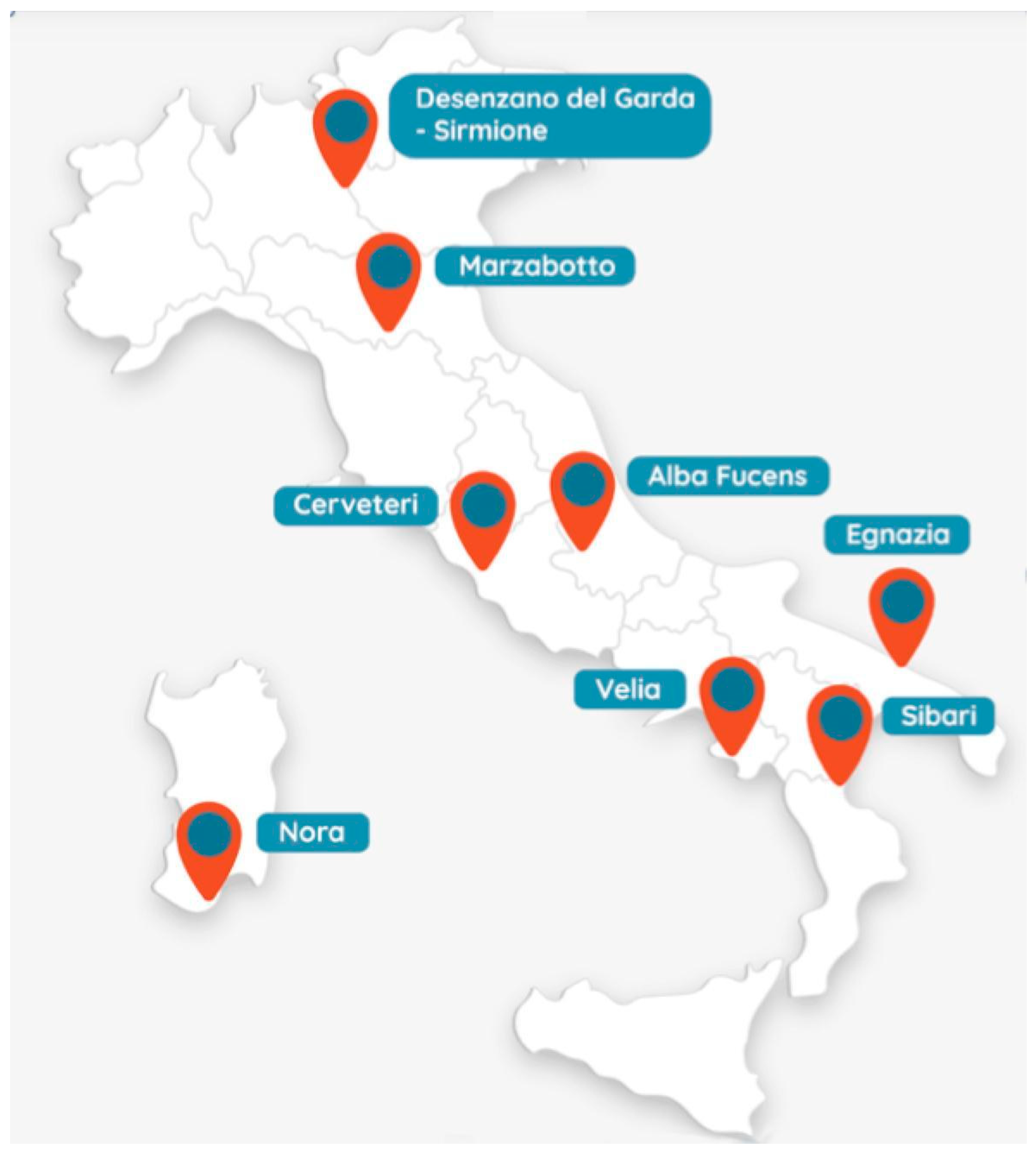
1.1. Aims of e-Archeo Project

e-Archeo is the first large-scale Italian project that brings together the public and private sectors in a process of co-creation and sharing of expertise.
It was promoted by the General Secretary of the Italian Ministry of Culture (MiC) and was realised thanks to the support of ALES, an in-house company of MiC.
The main objective of the e-Archeo project is to create an innovative multimedia platform that can narrate the contexts of some archaeological sites of national interest through different communication formats, making them digitally accessible.
So far, e-Archeo has involved eight important archaeological parks spread across Italy whose narrative potential had not yet been fully expressed: Sirmione and Desenzano (Lombardia region), Marzabotto (Emilia-Romagna region), Cerveteri (Lazio region), Alba Fucens (Abruzzo region), Velia (Campania region), Egnazia (Puglia region), Sibari (Calabria region) and Nora (Sardegna region) (Figure 1) [1].
Further and more specific objectives of the project are:
(1) To represent the richness of Italian archaeology, which is not limited to the large sites crowded with visitors but covers the entire national territory;
(2) To show the strength of the cultural integration that made the mosaic of peoples with different experiences and cultures who occupied Italy at the beginning of the first millennium a unity under the supremacy of Rome. The choice of sites was therefore dictated by the variety of their origins: Etruscan cities, Greek, Phoenician and Roman colonies, and indigenous settlements, which well illustrate how different realities gradually adapted to the social life of the Romans;
(3) To restore, thanks to virtual reconstructions, the third dimension that was lost over the centuries;
(4) To highlight the relationship of each site with the territory and with the major trade routes (sea, rivers, roads, etc.); great importance was therefore given to the holistic view, in addition to the monographic one, and virtual reconstructions on a landscape scale were attempted for the first time, for some sites;
(5) To represent and narrate the evolution of sites, from foundation to abandonment through the visualisation of the current state (the archaeological landscape) and virtual reconstructions referring to one or more past phases of life, in a kind of mixed reality experience. The selection of monuments or contexts was conditioned by their importance, as well as the state of advancement of studies and documentation that could be made available;
(6) To give emphasis to a wide range of contexts: places of public life (forums, basilicas, streets, squares and markets); sacred spaces (temples and sanctuaries) and leisure buildings (baths); ample emphasis was placed on necropolises and funerary goods, which provide us with important documents for the knowledge of funerary rituals and daily life. There is no shortage of private spaces, the houses, exemplified in various historical phases, from the archaic period to late antiquity, but also the villas, which are emblematic of luxury and, at the same time, show the close relationship with the territory;
(7) To design a communication plan that takes into account the variety of users to be reached. Various tools and communication styles were therefore implemented to illustrate the different contents: we provide to the scholar all the information to follow the process of virtual reconstruction (levels of reliability, sources and interpretative processes); captivating narratives are instead provided to the curious visitor, reconstructing perspectives that are generally missed.
The project devotes special attention to inclusion aspects, proposing solutions suitable for a variety of targets including people with disabilities.
e-Archeo has strongly demonstrated how virtual reconstructions are not only a tool to convey consolidated knowledge. On the contrary, they are a powerful means of study, simulation and comparison between multiple interpretative hypotheses. In fact, virtual reality, as a form of visual representation, gives shape to abstraction and requires the formulation of precise interpretative choices, consistent both with archaeological evidence and with the historical background, cultural and structural patterns (integration of bottom-up and top-down processes). The reconstructive process is able to easily bring to light the inconsistency of some previously accepted hypotheses and reopen the discussion between experts until new shared solutions are found. It is plausible to state that virtual archaeology and virtual reconstructions can contribute to the history of the studies by actually increasing the knowledge of the archaeological contexts.
The e-Archeo project, which adopts the principles of Open Science, stands as a replicable and reusable model for other sites in Italy and abroad.
The Institute of Heritage Sciences of the National Research Council (ISPC-CNR) was commissioned by ALES SpA to conceive and design the multimedia and technological solutions, to coordinate the executive production and to take care, in particular, of the development of contents on the Etruscan site of Cerveteri. Moreover, the production of all the contents has been conducted through the participation of 10 universities, the Italian Archaeological School of Athens, 12 Creative Industries, accessibility experts and National Italian Television (RAI Cultura), in collaboration with the local Superintendencies.
Many technological solutions developed in the e-Archeo project are largely used in archaeology and the cultural heritage domain. The level of originality and innovation of the project consists of (1) the outstanding quality of contents that represent the state of the art of the studies related to these eight archaeological sites, expressed also through virtual reconstructions; (2) the exposition and formalisation, alongside the narrative contents, of the scientific back-end that supports the reconstructive process in archaeology, that has been explained to the public; (3) the production chain and the interlocution among different actors, from the public, research and private sectors, who are not used to dialogue and sharing creative processes and know-how; (4) the accessible solutions adopting the universal design principles, with particular reference to e-Archeo Tactile installation; (5) the open approach and the FAIR principles applied to all the datasets produced, which guarantee their long-term survival and reusability.
The project was developed during the pandemic period when the use of shared technologies and interfaces was highly discouraged; therefore, the use of personal devices had to necessarily be the preponderant choice. However, thanks to the platforms used and the strategies adopted, the contents are today permanently accessible by a wide range of users. Moreover, the managers of cultural venues are able to adapt and deliver the cultural proposal in different ways, depending on how the user experience is configured at each site.

1.2. Structure of the Paper

The aim of this article is to provide the general context of the vast e-Archeo project, discussing its objectives, methodologies, strategies, working methods and results. This general scenario will hopefully be followed with further scientific contributions dedicated to specific aspects by the various research groups involved.
This paper develops through four main sections. In Section 1, the introduction, the aims of the e-Archeo project are presented: the reasons that determined the choice of the archaeological sites; the scale of representation from the holistic to the monographic vision; the purpose to increase their digital accessibility and the use of virtual reality not only as a tool of valorisation and narrative enhancement but also as a means to increase the knowledge of the archaeological contexts. Then, we deal with the state of the art of digital platforms for VR and VR experiences in the field of cultural heritage and also the accessibility, interoperability and reuse of datasets in the field of virtual archaeology.
Section 2 is about materials and methods. In the beginning, we present the workflow, methodology and tools designed to allow a heterogeneous team, composed of research institutions and creative industries, to produce together; we consider the critical aspects and benefits of such collaboration. Then, we discuss 3D contents: 3D modelling guidelines for content creators, aiming at both narrative and scientific consultation, for different kinds of user experiences. Finally, styles and languages adopted in the different audiovisual products are discussed.
Section 3 presents the results of the e-Archeo project, introducing the several outputs that have been produced for different moments of the cultural experience and addressed to diverse targets: in presence or remotely, before, during or after the real visit, in collective or intimate conditions of use, and in some cases, following the universal design principles for wide accessibility. For each application, the purpose, main characteristics and functionalities are presented, as well as the condition of use and the technological sustainability.
Section 4 is dedicated to the general conclusion: the added value that the e-Archeo project has generated, the further activities expected by the archaeological parks to enhance their cultural offer, starting new promotional or educational initiatives thanks to the applications that have been created or reusing open digital dataset for new productions.

1.3. State of the Art on XR and Accessibility for Cultural Heritage

The field of digital technologies related to the enhancement of archaeology, and more generally of cultural heritage, returns very often in the national and international scientific debate. The conspicuous number of papers, Special Issues and congresses on digitisation, 3D reconstruction and methods for the accessibility of digital content confirm this trend. In recent years, many Italian cultural institutions, such as museums and archaeological sites, are equipping themselves with digital content, thanks to virtuous awareness-raising actions by the Ministry and local administrations. The challenge introduced by the massive digitisation of Cultural Heritage is to build experiences and interactions around digital objects that allow the emotional involvement of the user in order to trigger the knowledge process [2].
Besides the ever-increasing potential of the internet, mobile personal devices and virtual reality technologies have encouraged research laboratories and private companies to develop platforms and applications offering multimedia content and virtual reconstructions to visitors of museums, cities and archaeological parks. CNR ISPC also has largely experimented in this field. A few examples will follow just to give an idea of the variety of proposals. The project “Matera Tales of a city” in 2009–2012 was conceived to support the public while visiting territories and sites in Matera, UNESCO Heritage, in southern Italy [3]. In specific points of observation, the users were invited to explore 360° panoramic views on their mobile devices, showing how the present contexts might look in various ages of the past, represented through virtual reconstructions superimposed and selected through a timeline, supported by storytelling.
In 2019, a qualitative study was carried out by Sheffield Hallam University aiming at better understanding the use of 3D reconstructions as part of a visit to a heritage site [4]. The same content was deployed on two devices: a tablet providing augmented reality, with past reconstructions overlapping onto the real world and a headset for an immersive experience in a VR reconstruction of the past. The results showed that an AR setting is preferred when possible to compare today with the past; VR is preferred to contextualise the visit in an environment that was originally monumental, but today, almost lost.
In 2020, the ArkaeVision VR application, realized by Digitalcomedia in collaboration with CNR ISPC, developed digital solutions to valorise the sites of Paestum in southern Italy [5]. Visitors could virtually travel into the ancient temple dedicated to Hera, wearing an HTC VIVE, an immersive viewer with a motion capture system. A methodology and a toolkit to profile users were designed in order to configure an optimal personalized experience. The experience required a dedicated controlled set and staff assistance to the public. Despite the beauty of the contents and the innovation of the technological proposal, the installation did not go beyond a short experimentation on the site, as it was too complex for local cultural operators to sustain in the medium and long term. The software was not open source, and the digital assets could not be reused by third parties.
The last example, still different, is the Innova Patrimonio project, developed by CNR ISPC in collaboration with Italian Creative Industries [6]. It aimed at the tourist enhancement of the peripheral territory, in particular, of small historical villages. The traditional descriptive approach of itineraries and monuments is replaced by a dramaturgical representation of stories, ways of life and imaginary dimensions, told by actors and also by local inhabitants. This hidden soul is shaped by acting, virtual reconstructions and mixed reality environments. Cinema, theatre, documentary and computer graphics merge in this new representation of the village which the visitors can access on their mobile and on a website [7]. The project was based on an open platform developed to share content and create apps for guided tours of cultural sites.
Generally, the most complex and delicate part of multimedia and technological enhancement is the experience design linked to the digital content since there are countless factors to consider [8]. It is necessary to make choices and be aware that quality design cannot please all users and adapt to all contexts.
The integration of real and virtual content in museums and archaeological sites can be achieved through multiple technological solutions adapted to various needs. The eXtended Reality (XR) includes all combinations of real and virtual environments and the various human–machine interactions generated by computer technology [9,10,11]. Following the reality/virtuality continuum [12], between the real environment and virtual reality (VR), we find mixed reality (MR), which aims at blending real and virtual environments, and includes various intermediate levels: augmented reality (AR), more in dialogue with the real world, and augmented virtuality (AV), closer to VR.
AR improves the perception and understanding of the natural world by superimposing virtual information through an interposed device (a smartphone, tablet or glasses) or a projected pattern. It is possible to apply it both at the architectural scale to see reconstructive hypothesis in situ [13] or contextualise diagnostic analyses and layers on 3D models [14] and at the scale of detail to interact with virtual artefacts [15] or visualise additional information about them through the revealing flashlight technology [16]. In AV, the blending of real and virtual worlds is maintained, but the aim is to augment the virtual one with elements from the real one. This application is not particularly common in archaeology and cultural heritage, whereas it is more widely used in 3D videoconferencing, telepresence, infotainment, gaming and education.
Recent open standards such as WebXR allow immersive VR and AR presentations of 3D content through a simple web page without any installation. However, this standard is still in the process of being integrated into browsers in commonly used devices. MR or AR experiences can be developed in various ways and at various levels of technological complexity [17].
AR in the proper sense is based on the principle of tracking. The software automatically recognises some significant and well-defined points (features) of the real space (geometry of a building or space) and ‘hooks’ the corresponding virtual contents onto them by means of geolocalisation, feature recognition, tracking technology, optical sensors, accelerometers, gyroscopes, etc. The correct overlap between real and virtual content can be calculated in real time, based on specific software algorithms, or offline. In the truest concept of MR/AR, feature tracking is calculated in real time, and the experience must necessarily be lived on-site, with all the environmental and logistical variables that this entails. The calculation requires the use of dedicated and generally proprietary devices and software platforms. There are some device and platform solutions implemented by large industries (Google, Apple, etc.), but they are not simply usable by all people, requiring non-trivial spatial calibration and setup processes before being used. Despite these sophisticated systems being much more projected into the future, they are currently still imperfect in their aesthetic rendering and usability, with the consequence of a possible penalisation of the cultural experience. The focus in these cases shifts more to technological innovation rather than to content.
Offline calculation refers instead to pre-processed visualisations in which the camera tracking between real and virtual content has been previously calculated and the output of the scene is a movie in which the two layers, real and virtual, are already merged and rendered together. The user can observe such animations in 360° using the sensors on the device (compass, accelerometer and gyroscope). Therefore, if such an experience is activated in the same real place to which the scenario refers, a collimation impression will be possible: the user, who has reached the observation point, will be asked to orient himself according to specific coordinates and the exploration in MR will be truthful, thanks to the orientation sensor technology. This solution, although technologically less pioneering, is at present more robust, generally of better quality and easy and immediate in use. It is also compatible with the most common user devices (smartphones, tablets, cardboards, up to immersive head-mounted displays, etc.). The advantage of offline tracking with device orientation is that the experience can also be enjoyed remotely, just as with VR, without necessarily being on-site.
This distinction between tracking features in real time or through offline calculation with device orientation is therefore fundamental and determines distinct choices in the design of the user experience and the conception of the entire application.
VR focuses on enhancing human presence and interaction with a computer-generated environment without any connection to the real world. Within VR, there are more or less immersive experiences and different types of interaction: from fruition via smartphone, tablet and desktop devices [18] to semi-immersive installations with gesture-based interaction [19,20]; from immersive projections [21] to HDM devices [22].
When choosing the most appropriate technology for a multimedia enhancement project, it is necessary to establish the type of use aimed at, bearing in mind the limitations of the various resources. AR in archaeology, for instance, can be effectively applied to show a disappeared context virtually reconstructed in situ. Therefore, it has the limitation of being extremely site-specific and not being able to provide an adequate experience through remote usage, limiting the accessibility of content only to those who can physically reach the site or the museum. In VR, an important discriminator is the rendering calculation of 3D scenes. Real-time rendering (RTR) allows greater freedom of interaction and movement within virtual environments. However, it has the technological limitation of tying fruition to specific contexts where high-cost fixed installations are present since the rendering calculation must be performed by high-performance devices in order to guarantee a high-quality graphic rendering. On the contrary, applications built through pre-rendered content, such as 360° panoramas, also allow their fruition through mobile devices, albeit with the navigation limited to zoom and rotation commands only. This second case, which concerns all applications conceived as virtual tours, also makes it possible to bypass the criticality of sharing single-user devices for cultural fruition in the COVID-19 era.
In the e-Archeo project, it was decided not to use tracking technologies for many reasons, although we were aware of the potential they could integrate. After a careful evaluation of the context in which the project was conceived and the leading causes of the decline of technology platforms related to previous valorisation projects, we focused on two main objectives: to reach as many users as possible and to create sustainable usage models for the management by museum institutions to ensure their durability. Although not introducing any technological advancements, the strength of the e-Archeo project lies in its dissemination and long-term sustainability. The challenge was to realise a modern, high-quality enhancement project which could be adapted to different museum contexts while keeping the technological framework as simple as possible. Tracking technologies would have required software updates to ensure content enjoyment over time, whereas the navigation of reconstructions through 360° panoramas on a ‘liquid’ (to be enjoyed on various devices) web-based platform ensures a wider spread of use. Tracking devices to be used in situ would have required the presence of museum staff trained in the operation and maintenance of the installations, which museums cannot always provide. The latter is often the cause of the decline and non-use of many technological applications.
Another important aspect related to archaeological and museum enhancement concerns accessibility in its various forms: spatial, sociocultural, cognitive and psycho-sensory inclusion. According to ISO 9241-11:2018 [23], the term “accessibility” refers to the extent to which products, systems, services, environments and facilities can be used by people in a population with the widest range of user needs, characteristics and capabilities to achieve an identified goal in an identified context of use. As a public place of education and culture, the museum encourages collective communication, sharing and social exchange.
The new ‘Museum’ definition drawn up by ICOM in 2022 [24] emphasises that “open to the public, accessible and inclusive, museums foster diversity and sustainability”. The concept of accessibility in its declinations promotes a whole series of actions based on the universal design principles, as theorized in 1997 [25], built to respond to the specific needs of people, through the diversification of multisensory contents able to stimulate the participation of all [26].
Despite the principles of UD, the focus of institutions, designers and architects was initially mostly on users with physical difficulties and in wheelchairs; thus, the legislation was mainly addressed to measures and prescriptions of space sizes rather than to “solutions for all”.
Gradually, a growing awareness of better inclusion of larger users’ needs took place, also extending to different sensorial and cognitive difficulties.
In December 2019, a new version of the European guideline “accessibility requirements for Information and Communication Technologies (ICT) products and services” [27] was published to specify functional accessibility requirements applicable to ICT products and services, to be used in public procurement in Europe. This standard has been drawn up under the competence of the authority federated to “Ente Italiano di Normazione” (UNI), “Tecnologie informatiche e loro applicazioni” (UNINFO) and became part of the Italian national legislation on 17 December 2020. The document is suitable for web-based technologies, non-web technologies and hybrid technologies using both. It includes software, hardware and services. Most parts of the principles here established are addressed to improve the accessibility and usability of multimedia applications and comfort of use by people who are blind and deaf or by visitors with limited abilities in vision and hearing, visitors in wheelchairs and persons with cognitive disabilities. However, they can improve the experience of all users, generating ease of use and well-being. This means that information has to be delivered not only by means of a unique media/sensory solicitation but more than one.
In the specific field of museums and archaeological sites, creating accessible content means allowing their fruition also to those who cannot physically go to the sites, or who cannot perceive using the five senses, diversifying the type of language (text, audio, pictures), integrating tangible interface [28,29] and distinguishing the communication format in order to reach both a generic and a specialised audience.
In the latter case, it is crucial to accompany the virtual reconstructive hypotheses with the scientific data that supported and directed them to share the reliability of the reconstructions, the sources and the interpretative processes adopted. Over the years, the scientific approach to simulative models of the past and their communication has been discussed to ensure academic rigour in visualisation methods.
Linked to the topic of scientific data accessibility, open data and FAIR principles have been introduced since 2016 to provide guidelines and best practices for optimising data reuse in scientific research [30]. According to these principles, data should be:
  • Findable. Automatic and reliable retrieval of datasets depends on the persistent identifiers (PIDs), such as DOI, Handle or URN, and descriptive metadata, which should be recorded in repositories that machines can also index;
  • Accessible. The data or the metadata should be stored in repositories that make them persistent over time and traceable on the network;
  • Interoperable. The data format should be open and interpretable by various tools, including other databases. Metadata should also use a standardised language shared internationally by different indexing services;
  • Re-usable. Data processing should conform to the standards or protocols recognised by the relevant scientific communities. Data and metadata should be described and documented so they can be replicated and/or combined in different contexts. The reuse of data and metadata should be declared under one or more open licences.
In order to answer some of the questions related to XR technologies and accessibility, the e-Archeo project turned to previous scientific research conducted by the CNR ISPC, which will be discussed in more detail in the following paragraphs: a platform for VR content (ATON) [31]; a method for mapping levels of reliability, sources and interpretative processes on 3D reconstructive models (extended matrix) [32]; research in the field of universal design with particular reference to tangible user interfaces (TUI) [28]; guidelines for the metadata of cultural heritage datasets in the Zenodo platform [33]. Zenodo is an open access repository for research publications and data distributed under user-chosen creative commons licences. It aims to share scientific material and to archive it in the long term.

1.4. General Strategies Adopted and the Added Value of the Project

1.4.1. Role and Use of Virtual Reconstructions, Levels of Representation, Technological Choices

The use of virtual reconstruction has a central role in the e-Archeo project [34]. In order to favour the understanding of the archaeological space and of the chronological evolution of the site, three kinds of visualisation and storytelling have been implemented, both in the case of holistic vision (territorial scale) and of specific buildings or contexts (monographic scale):
(1)
Today’s “archaeological landscape” associated with descriptive and narrative contents;
(2)
“potential ancient landscape”, through virtual reconstructions associated with descriptive and narrative contents;
(3)
“interpreted landscape”, through the application of symbolic colours to the various elements of the virtual reconstruction, corresponding to different reliability levels; these latter are also connected to the interpretative sources and processes that have supported the reconstruction. This visualisation is associated with the scientific back end.
These visualisations may consist of:
  • 360°, still or animated, interactive rendering (equirectangular projection);
  • Simple VR scenes, in case of visualization of museum objects, accessible also on common smartphones.
The metaphor of MR is managed by a web app through the visitors’ personal mobile devices.
The recommended solutions for scenario visualisation are 360° panoramic views. This choice breaks down problems of technological compatibility, computational overhead, the complexity of interfaces, user disorientation and consequently the loss of motivation.
Therefore, for each context, these three levels are rendered from camera positions perfectly overlapping so that the user can switch among them without becoming disoriented: such alternation allows them to better compare and understand the space, through the perception and critical elaboration of redundancies and differences [35].
Moreover, the integration of the three representations increases the accessibility of the archaeological site (and therefore the usefulness of the applications) in case users cannot perform a real visit experience.
Rendering in a realistic graphic style is associated with the narration or description of the environment; rendering in a symbolic graphic style is associated with the scientific back end and interpretative sources. Descriptions and narrations are available both in audio and written formats to enhance accessibility.
Besides the general exploration of the whole environment, even a richer interactive experience is possible thanks to the integration of a perfectly overlapping semantic map [36] on the rendering. This semantic map defines, more in detail, meaningful interactive elements in the scenario that can be identified as transparent flashing colours and can be queried, in order to go deeper into the contents (Figure 2).
Virtual reconstructions have offered the opportunity not only to simulate ancient urban and architectural contexts but also to contextualize objects coming from the site and today preserved inside museums (Figure 3).

1.4.2. A Multichannel Project

e-Archeo is a multi-channel project, as it delivers content through a variety of media and different languages in accordance with the context of use, and for targets with diverse technological and archaeological backgrounds.
Starting from a common dataset of contents, 3D models, various applications were developed, both online and site-specific, for a collective or intimate experience, each one using a specific experience design, style, language and interaction interface and technological solution.
For this reason, 3D models have been used and rendered differently in various applications: as linear animations for movies, as real-time interactive objects, as 360° panoramas, as static images and even as printable tangible interfaces.
The online platform is fundamental to ensure widespread accessibility to the contents and to propose integrated designs and common solutions for eight archaeological sites, given the complexity of the project.

1.4.3. Sustainability and Long-Term Preservation

In terms of technological solutions and interaction interfaces, it is important to consider that the project was developed in 2021–2022, during the pandemic. This condition also determined some constraints since the Superintendencies firmly discouraged the use of shared devices in favour of the widest use of personal devices. In many cases, Superintendencies expressed general concerns also about the medium–long-term sustainability of technologies and their daily management because of the shortage of economic and human resources to be addressed to support visitors. For this reason, the online platform constitutes the backbone of the project.
However, some site-specific installations were also realized in museums in Cerveteri and Sirmione. In collaboration with experts in accessibility, such installations allowed us to experiment with innovative solutions, designed according to the universal design principles.
Furthermore, about 7 months after the public presentation of the project (which took place on 6 June 2022 in Rome), thanks to the fading of the COVID emergency, we are now recovering the use of shared interaction interfaces within museums instead of individual personal devices so as to favour a more collective experience and social cultural exchange.
The main principles leading the multimedia design of the e-Archeo project were: innovation, sustainability (both in terms of technologies whose daily management and maintenance rely on the archaeological parks’ personnel and of contents that can be reused by the Superintendencies for new developments), open science, synergy and know-how exchange between the research, public and private sectors.
Another issue of the project, connected to the long-term sustainability and usefulness of digital productions, is the open data and open source policy. Both universities and creative industries have been convinced to publish on the Zenodo European platform [37]:
(1) All the original data coming from their previous research or surveys, brought as a ‘dowry’ and made available at the beginning of the project (e.g., point clouds, photos, plans, landscape studies, written texts);
(2) All the datasets processed and produced during the project following the new guidelines and the template given by the e-Archeo coordination team (e.g., 3D models, rendering, movies, screenplay and storytelling, scientific backend).
Zenodo is a repository on the web, aiming at collecting, preserving and diffusing the scientific production of an institution (or of a discipline), allowing external users to access the digital objects which it includes and their metadata. Zenodo is not the only repository with such characteristics existing today, but it has been specifically created for scientific institutions and it follows FAIR principles [30]; it is managed by CERN [38] for OpenAIRE (UE) [39].
Specific guidelines and tutorials have been designed by the coordination team also to structure the scientific backend [40] metadata and paradata to be associated with the published contents, also useful for making data searchable and findable in the future [33]. The e-Archeo collection [41] was created in Zenodo in order to take under a common “umbrella” all the contents produced in the context of the e-Archeo project. We consider a successful result to have convinced academies and private industries to release their research and products for free on Zenodo in interoperable formats. Of course, they were free to choose the kind of license they preferred, even if the “Creative Commons Attribution NonCommercial Share Alike 4.0 International” one has been encouraged by the coordination team [42]. This kind of license allows the reuse of data exclusively for scientific purposes and, even in the case of modification, data must be published keeping the same license. This condition should generate a virtuous effect, as data introduced in the international scientific circuit will be multiplied in a series of other projects, being reusable even by the e-Archeo team.

1.4.4. Runtime Online Platform

It is important to clarify that this platform, devoted to the long-lasting preservation of datasets and their metadata, does not correspond to the runtime online platform, where the web apps and their contents can be played by the common users of the project. In fact, the servers and services for content streaming and runtime web apps have different characteristics from the other repository. Thus, the two services are addressed by two distinct platforms (although they may coexist on the same physical server).
A web app is an application that can be used via a simple browser; it does not require any third-party software installation, and it is accessible just by typing a URL from any platform.
For instance, the web app e-Archeo 3D [43] delivers multimedia, virtual reality (VR) and mixed reality (MR) content to users while they are walking through an archaeological site, or even remotely. This platform has been conceived for communication purposes, with a specific user graphic interface (GUI) and user experience design. The software has been centralised on a unique server managed by ALES SpA, together with the contents, making maintenance and updates easier. The following contents and web apps are running on this server:
(1)
“e-Archeo.it” website;
(2)
“e-Archeo 3D” web app, allowing audio-visual experience (multimedia and VR, 360° MR);
(3)
“e-Archeo Voices” web app, to access podcasts for each archaeological site.
Audio stories in the podcast may be more rewarding in case the sunlight on the archaeological site hampers the perception of visual content on the display, or the visitor prefers a ‘lighter’ enjoyment of the content without engaging with the gaze on their device.
In most cases, the audio stories, VR or MR contents provided by the web apps refer to specific points of interest of the archaeological site; a map is the main interface to start the experience in “e-Archeo 3D” (Figure 4).
Therefore, at the discretion of park directors, these specific points could be indicated along the archaeological visitor routes, by means of QR codes, to let visitors experience them in defined locations using their personal devices. Alternatively, visitors could live an immersive experience, putting their smartphones in a cardboard frame and starting the web app in immersive mode, or renting other head-mounted displays, for instance, the Oculus Quest2, at the ticket office of the site. Three-dimensional content and platforms are compatible with all these solutions.

2. Materials and Methods

2.1. Methods and Tools for Working Together and Creating the Production Chain

The General Secretariat of the Ministry of Culture (MiC) commissioned the e-Archeo project to Ales spa and built it on a solid mix of competencies and skills provided by different stakeholders. The partnership’s main objective is to strengthen the capacity of governmental institutions, research organisations and creative industries to work together in the valorisation of Italian cultural heritage, sharing ideas and developing efficient and innovative working methods.
The Digital Heritage Innovation Laboratory (DHiLab) of the CNR ISPC was responsible for the conception and multimedia design for the eight sites involved and for coordinating all dissemination outputs’ executive direction. It defined the technical criteria to be met in the virtual reconstruction work, the methods of the scientific mapping of sources and interpretation processes on 3D models and the choice of the most usable and sustainable technological solutions. It identified, together with Ales and the MiC, the user experience design, the communication formats, filmic and interactive, and the methods for sharing data on open platforms in function for their future reuse. Given the research activity that the ISPC has been carrying out for years at the archaeological site of Cerveteri, the institute contributed to the collection and systematisation of the available study data, the multimedia design for the Cerite Museum and the realisation of the various outputs.
Leading Italian universities and research institutes that stood out in the scientific context for previous studies conducted at the involved sites were selected. These institutions shared their solid knowledge derived from years of investigations, helped collect and select the scientific data already in their possession, assisted the creative industries in creating reliable 3D reconstructions and multimedia content, produced some specific content and provided support and advice on the topics of their competence.
The creative industries translated the client’s needs into concrete products, referring to recent digital communication and multimedia technology trends. This action contributed to the realisation of a ‘multi-channel’ project, innovation and contamination between the diverse expertise of the creative industries.
The e-Archeo project also made use of the specific contribution of experts called upon to validate the coherence of the content concerning the universal design principles and compliance with the criteria for multimedia accessibility to cultural heritage. In particular, the National Tactile Museum Omero and LIS/IS experts were involved.
The authors of this paper coordinated the activity in all its planning and implementation phases, supervising the scientific and technical aspects, ensuring the quality of the results produced, their homogeneity and adherence to deadlines.
The e-Archeo project was developed for 18 months.
The first phase involved the acquisition and systematisation of existing scientific data from the research groups operating at the individual sites. There were both technical/graphic and textual data. Among the technical and graphic documents provided were data concerning topography (GIS, DEM, thematic maps: chronology, functional areas, infrastructures, viability, etc.); the ecosystem (the mapping of current/antique vegetation and land use); previous surveys and digitisations (3D surveys, geophysical surveys, digitisation of finds, videos, photos, etc.); 3D reconstructions already carried out or preliminary studies to reconstructions. The textual-type document concerned a questionnaire, the same for all archaeological sites, designed to gather basic notions to construct the subsequent narrative interventions so that they would start from homogeneous themes. The universities were asked to write about the following:
  • The founders of the city (who they were, where they came from, how they arrived, why they arrived, etc.);
  • The characteristics of the settlement (morphology, functional areas, viability, residential buildings, sacred buildings, necropolis, etc.);
  • The population’s cultural identity during the time (funeral rites, care of the sick, crops, technologies, clothing, etc.);
  • Social and political relations with neighbouring populations (military techniques, enemies, allies, contamination with surrounding cultures, etc.);
  • Known personalities, significant monuments and objects representative of the culture.
The work was carried out through three main phases:
  • Preliminary phase:
    • Existing data collection and organization on a common repository, analyses and optimization;
    • Decision about the contexts to be virtually reconstructed and the selection of the most meaningful narrative subjects for each site;
    • Definition of interventions, output and strategies; elaboration of methodological guidelines and templates to be transmitted to all content producers;
  • Content production;
  • Development of the applications for public use and dataset publication on an open access repository for long-term archiving.
In phase 1, existing data and studies provided by the universities were organized according to a shared ontology, and they were archived into a centralized working repository, set by ALES, to which all persons involved had access. The data were checked for technical requirements. Then, they were analysed and synthesised. The first phase of the work was concluded with the definition of the interventions and strategies and the methodological guidelines to be provided in the next phase of the work: guidelines for the storytelling conception for the eight archaeological sites; the web platform for the use of interactive 360° panoramas and interfaces; the immersive multi-projection; the introductory film to the sites; the realisation of the virtual reconstructions; the mapping of the levels of reliability in reconstructions and source contextualisation and the good practices of open science.
The scientific data and guidelines were a starting point for the second phase. This step involved the virtual reconstruction of some monuments, the mapping of the scientific back end, the definition of narratives for the podcast and descriptions for the 360° panoramas.
A final phase involved the creation of the outputs presented in Section 3 and archiving and disseminating (via Zenodo) the scientific material produced.
Some innovative methods and tools (i.e., extended matrix and Zenodo) were not part of the cultural background already possessed by the project’s actors. For this reason, the procedures were simplified and training sessions were organised for knowledge transfer. At the same time, the project’s particular requirements were an opportunity to improve and implement some tools provided by the CNR, such as ATON (used as the basic framework for the e-Archeo 3D web app) with new functionalities. From the outset, the e-Archeo project partners supported the development of a new and synergistic working methodology in which research institutions and creative industries constantly worked together, each bringing their knowledge. This relationship enabled the transfer of know-how and the application of innovative practices for multimedia valorisation.

2.2. 3D Contents

Virtual archaeology concerns the process of study and interpretation aimed at reconstructing and simulating the past through digital technologies and a theoretical and multidisciplinary scientific approach. From a general point of view, reconstructions can be based on elements that are still visible or documented as visible in the past and can be placed with certainty in situ, on architectural forms and proportion theory, on figurative deductions, on comparative cases and cultural patterns. Creating 3D content with reconstructive hypotheses was one of the main objectives of the e-Archeo project.
Universities and research institutes identified the themes on which the creative industries worked according to the availability of archaeological evidence and previous studies that would allow reconstructive hypotheses. Where possible, reconstructions took place at different scales: from the landscape to the urban scale, from architecture to object (Figure 5).
Creative industries followed guidelines in their 3D modelling work. They were asked to produce 3D models with a reasonable balance between the number of polygons and the file weight. This request did not depend on the rendering the 3D models would undergo because a virtual tour through 360° panoramas was chosen rather than real-time rendering (RTR). Pre-rendered pictures have the advantage that they can be enjoyed from any of the user’s smartphone devices and are less prone to technological deterioration in view of the long-term sustainability of multimedia products. Therefore, the request for optimised 3D models was an economic matter in terms of the storage of the many files produced. The 3D models were realised employing a correct topology and an orderly semantic subdivision of the various parts, with a view to their possible reuse. The use of physics-based rendering (PBR) materials was favoured for the rendering of details, and the lighting of the 3D scene was set up with lighting sets capable of recreating environmental conditions similar to photographic footage to offer an optimal visual rendering.
The rendered pictures had an equirectangular format to be enjoyed as 360° panoramas and were used at different sizes: 16K for archiving, long-term survivability, reusability and downward scalability; 8K for the 3D web app when used from a PC; 4K for the web app in mobile mode. The 16K format was also used in the 3D web app version installed on three large monitors at the Cerite Museum in Cerveteri.
Semantic masks were associated with 360° renderings, allowing interactive hotspots to be implemented for in-depth analysis in the 3D web app.
Some 3D objects preserved in site museums were scanned three-dimensionally using the photogrammetric technique and sometimes they were virtually restored. These objects configured the furnishing assets of some reconstructive hypotheses, so they are contextualized in the 360° scene. Three-dimensional models of the most significant objects can be explored in real time in the 3D web app in order to allow in-depth analysis.
The scientific community agrees that it is essential to document reconstructive processes to create a semantic mapping that can indicate the level of reliability, sources used, comparative cases and interpretative processes (i.e., how sources were used and integrated). The research groups and the creative industries that produced the 3D models carried out this activity jointly. The mapping was conducted directly on the 360° renderings, simplifying the extended matrix method, which originally involved mapping information in the 3D model. The rendered pictures with the scientific back-end mapping present various colours related to different levels of reliability (Figure 6):
  • Red, to identify archaeological features documented in situ in the present or the past;
  • Blue, to identify virtual restoration work resulting from physical evidence (e.g., partial collapse of a wall);
  • Dark yellow, in the case of anastylosis with the repositioning of existing pieces but located elsewhere (e.g., in a museum);
  • Light yellow, in the case of anastylosis with missing elements;
  • Green, to identify reconstructed elements without concrete evidence, thanks to deductive processes (e.g., literary sources, architectural modules, comparative cases, typological similarities).
In order to make this information usable in the 3D web app, semantic masks were again used, which allowed the user to interact with the coloured fields to show the sources and interpretative processes connected to each colour.
The last type of 3D content was aimed at rapid prototyping to create maquettes for a tangible user interface (TUI) installation based on the universal design principles, which will be discussed later. In this specific case, three-dimensional data were acquired by a terrestrial laser scanner (TLS) and photogrammetry by the CNR ISPC. Subsequently, the CNR researchers were responsible for optimising the models for 3D printing (Figure 7), attempting to impart a degree of detail that could be perceived tactilely, thanks to the advice of the accessibility consultants.
The collaboration between universities and creative industries in the realisation of virtual reconstructions has improved the knowledge and interpretation of architectural contexts. The effort to imagine archaeological assets three-dimensionally to reconstruct them virtually has led to new questions and answers being sought.

2.3. Languages and Styles

The participation in the e-Archeo project of so many universities, selected on the basis of their past and present study and excavation activities at the various archaeological sites, of the superintendencies, of research organisations, active in the aspects of digital communication and user experience, as well as of creative industries, made it possible to elaborate content of the highest scientific quality and up-to-date with the most advanced state of the art in studies. With regard to descriptive and narrative content, a questionnaire consisting of 35 questions was prepared by the coordination team at the beginning of the project, which the universities were invited to fill out, with the aim of collecting as much narrative content as possible related to each archaeological site. Thus, homogeneous and comparable information was collected for each site, from which it would have been possible to set up the narratives for the various outputs (television videos, 360° panoramas in the 3D web app, podcasts and site-specific museum installations).
Once the detailed contents and communication formats were defined, the coordination team was able to provide the universities with guidelines and templates for the elaboration of the final texts (structure, length, style). The texts received were constantly monitored by the coordination team and modifications were requested at various stages, where necessary.
Creative industries generally approached storytelling with greater creativity in language, freedom in invention and style while respecting the content initially provided. They are in fact more accustomed to meeting public needs and thus seeking solutions with communicative impact compared to universities.
Especially for narrations elaborated by the universities, a stylistic adaptation of the language became necessary, carried out together with the coordination team.
Communication is a magical balance between science and art, mediated by technology, and, understandably, not all academic institutions are used to such a practice.
The guidelines that were given required not-too-descriptive and technical texts, different from traditional archaeological reports.
We wanted to make these contents warmer and more narrative, open to symbolic themes, relating to the living conditions of ancient peoples, their cultural identity, their cultural influences and inheritances from the peoples with whom they met or clashed, the organisation of their territory and cities, social relations between genders and between classes of different conditions, the religious sphere and ritual practices, the relationship with deities, resources and productive capacity, the technology they had at their disposal, etc.
Certainly, town planning and architecture were important themes, but always in this light, even if, in many cases, scholars cannot be sure about such topics.
Above all, contents that are already visible and implicit in images accompanying storytelling should not be described. The text had to enrich and add another metaphorical, symbolic level that goes beyond mere description (with the necessary exceptions: if some important things in the image are not clear or obvious, it is good to explain them).
Another indication concerned the association between text and images, which should always be relevant and contextual. The image, or an element present in it, should be the starting point of a story.
In short, we wanted to translate science into compelling communication, to tell stories that stimulated the user’s imagination and projected them into an ancient scenario of life and values, fuelling their motivation to learn.
For this reason, it was also suggested that the concepts should be formulated in a language that was not erudite, but lively, direct and essential, which does not mean shallow, suitable for accompanying images and not self-referential as in a book. Too many adjectives, for example, were considered an unnecessary burden (e.g., the majestic ruins, the elegant colonnade, the lively floral motif). In a barer language, each word becomes profound and meaningful. The users thus feel motivated to continue the experience, because they have open questions that are gradually answered and, step by step, the mosaic will harmoniously be composed.
We divided the project into two communicative levels: (1) narrative, which had to be warm and exciting, and (2) scientific, reserved for the scientific back end, which was more erudite and technical.
Narrations are available in both audio and written formats, in accordance with the accessibility issue.
Audio stories of the podcast (e-Archeo Voices) [44] are not conceived as traditional audio guides; on the contrary, they represent the fullest expression of storytelling within the project, also because they have been composed by a creative writer, based on the contents initially provided by the university, and revised upon completion by the same universities and CNR. The narration of each site takes place in the first person through the voice of a real-life or imaginary but historically plausible character or through the voice of iconic objects witnessing urban and social changes over the centuries. The voices were provided by professional actors or voice actors accustomed to working in theatre or film, an essential condition that greatly emphasised their expressiveness. The stories are also accompanied by evocative soundscapes that enhance emotional involvement and sensory immersion.
In the site-specific installation, ”e-Archeo Tactile”, realized for the Cerveteri archaeological park, the universal design principles were applied. Texts were spoken in Italian and in English and also translated into Italian and International Sign Language, accompanied by subtitles.
Sign language has specific linguistic rules and its own narrative order. The texts, initially drafted by the scientific team, were therefore revised by the accessibility experts, and, in several cases, they were modified, so that the narration worked well in all languages, Italian, LIS, English and IS. The sign language interpreter not only performs gestures but also makes use of very expressive facial expressions; he is synchronized to the spoken audio and subtitles, as well as to the commentary images; therefore, all linguistic adaptations must be well harmonised in the multimedia experience.
In some cases, the order of the sentences has been changed: too-long and information-laden periods have been simplified and divided into several simple sentences, whereas sometimes very short periods have been expanded to be more explicit. Technical terms were replaced by commonly used synonyms. The resulting texts in Italian were translated into Italian Sign Language, then into English and finally into International Sign.
Thanks to the consultancy of the Statal Tactile Omero Museum [45], spatial information was added to make the content fully accessible to blind and visually impaired people.
The LIS and IS interpreters took special care in the expressiveness of the face and hands. The result is a very inviting and informative language for all the users, without ever betraying the relevance and richness of the content (Figure 8).
The spoken comment of the videos presenting the eight archaeological sites was composed by the authors of the Italian national television (RAI Cultura) in a style suitable for television audiences. First of all, these videos were broadcasted in a series on RAI Cultura; later, they were published on the e-Archeo project website and included in the e-Archeo 3D web app. They are also available to museum curators to be reused within the site museums. The RAI authors started from the storytelling questionnaires compiled by the universities, reworked them and then submitted them again for scientific validation by experts while maintaining total stylistic authorship.

2.4. Platform Requirements

For a long time, we reasoned about the choice of the software platform to develop the 3D web app and manage real-time 3D content, interactive 360° panoramic views, semantic maps and multimedia content. The most convenient strategy was considered to use an already existing platform that had the appropriate basic requirements and could be customised with additional functionalities and a new user interface in order to satisfy the needs of the e-Archeo project.
The existence, both on the market and in research institutes, of platforms with useful features led us to make an initial benchmarking and in-depth evaluation with the involved institutions so that we could converge on an optimal solution.
There are many platforms for the creation and publication of interactive 360° panoramic images on the web, such as Pano2VR from Garden Gnome, [46], which allows linking multiple panoramas together, creating multimedia hotspots; however, it seemed too limited for all the functionalities that we wanted to develop, and it was not open source and customisable. The Fraunhofer Institute for Open Communication Systems has developed VISCOM, a very powerful technology for extended reality (XR) [47]. Depending on the application, the platform runs on various smartphones, tablets, AR glasses (e.g., Microsoft HoloLens, Meta2) or VR glasses (e.g., Oculus Rift, HTC Vive).
Well-known game engines, such as Unity 3D [48] and Unreal [49], with developers all over the world, are used internationally by the game and virtual reality industry, and they are also widespread in academia. They are not open source and require licences for publication. These game engines allow the implementation of complex 3D scenes, with sophisticated animations and interactions.
A set of requirements were defined for the e-Archeo project, considering that accessibility and sustainability over time were fundamental issues.
The requirements identified are:
(1)
Compliance with the usability standards ISO 9241-11:1998, later updated by ISO/2014 [50], which define usability as “effective and satisfactory interaction for the user in terms of both efficiency and well-being. The aim of usability is to economise the cognitive effort of the user, proposing products that are easy to understand, to learn, to use, to remember, that avoid or make recoverable errors and that therefore gratify the user”;
(2)
Adherence, in terms of usability, to Nielsen’s heuristics [51], Norman’s guidelines [52] and the recent EU design and usability guidelines mentioned above;
(3)
Open source software in order to lengthen survival over time;
(4)
Compatibility with all web browsers (Firefox, Safari, Chrome, Edge);
(5)
Ability to adapt the same web application to multiple devices and presentation modes (multi-projection, immersive viewer, desktop, tablet, smartphone);
(6)
Automatic recognition of the device from which the web app is accessed to adapt the resolution of the displayed content;
(7)
Ease and autonomy for content providers to upload and publish data, without having to go through the platform developer, following simple procedures;
(8)
Persistence of content links over time;
(9)
Sustainability of economic management;
(10)
Management of videos through an integrated player (HTML5);
(11)
Management of 3D models in real-time graphic scenarios;
(12)
Management of 360° panoramas, both photographic and video;
(13)
Management of audio content, even more than one instance at the same time in the same scene;
(14)
Management of semantic mappings applied to the 3D models/scenarios;
(15)
Creation, by authorized content providers, of 3D annotations and metadata associated with 3D models; these annotations may contain text, images, audio and video; they are associated with specific areas or elements of the 3D scene or 360° panorama and are accessed simply by selecting that element of interest;
(16)
Interfacing with QR codes;
(17)
Integration with low-cost hardware solutions and single-board computers (e.g., Raspberry Pi);
(18)
Aptitude to manage gamification techniques, in perspective.
Furthermore, it was established that the web platform could integrate functionalities that were not absolutely mandatory, but desirable for improvement purposes:
  • Management of 360° 2.5D panoramas (panoramic image and depth map);
  • Support for marker-based AR;
  • Support for markerless AR;
  • Interfacing with motion capture (e.g., Leap Motion) or proximity systems to create advanced interaction models.
After the evaluations, ALES and the Minister of Culture proposed to choose ATON [53] as the development platform for e-Archeo 3D web apps. ATON is a WebXR platform developed over many years by the CNR ISPC, evolved through many national and international research projects [31]. The reasons for this choice are:
(1) The ATON platform presents all the functional requirements necessary to carry out the project; it is open source and licensed under GPL v3 [54]. The framework and the API have been published on Zenodo. The documentation available online is quite clear and exhaustive, which allows an easy transfer of know-how to third parties [55];
(2) The project has a scientific connotation since it involves the Ministry of Culture, the CNR (National Research Council) and several Italian universities; therefore, the promotion of a platform born and evolved in the research field was in line with the project’s philosophy;
(3) There are not many alternative open source platforms with similar functionalities. There are platforms for the visualisation of 360° panoramas, but many of them are proprietary, and, therefore, any maintenance or updating of content always requires the owners of the code, which can be a problem for public administrations (disruption of free competition, potentially higher costs). Moreover, if the developer fails, the platform often ceases to exist.
Faced with the choice of ATON, ALES asked the CNR, as the developer of the platform, to support the entire development chain, from customising the interface to implementing the various functionalities, to software and hardware maintenance. The web app was developed by a creative industry, a spin-off of Calabria University, after a know-how and technology transfer by the CNR ISPC, through documentation sharing, online training, example tests and tutorials.

3. Results

The three-dimensional reconstructions, the scientific metadata associated with them and the narrative content were incorporated into various multimedia applications to enhance the eight archaeological areas to reach the public in different ways, both in situ and online.
The outputs of the project are as follows (Figure 9):
e-Archeo 3D;
e-Archeo Voices;
e-Archeo Tactile;
e-Archeo HI—Human Interface;
e-Archeo Video;
e-Archeo Website.
The e-Archeo Website [1] is the latest output realised, collecting the whole project story, the actors, the methodology and the results. It offers access to all other web apps and to the Zenodo e-Archeo collection.
The site is also bilingual and follows the principles of accessibility. This output is designed for anyone who would like to learn about the project and has the curiosity to access the two online platforms: e-Archeo 3D and e-Archeo Voices.

3.1. e-Archeo 3D

e-Archeo 3D [43] is an interactive, browser-based application implemented on the open-source web platform ATON, developed by the CNR ISPC. It is a web app that visualises the eight archaeological areas through 360° scenes that can be interrogated and populated with various multimedia content: videos, pictures and 3D models of individual finds. The exploration is designed to be carried out in situ, to have valid knowledge support during a live visit of the archaeological sites, or online, to virtually reach the archaeological site from home or school. It is possible to select one of the eight sites using an initial map or a list on the right in the layout (Figure 10).
Within each site, the map proposes some points of interest corresponding to the location of the monuments reconstructed in 3D (Figure 11b). By clicking on the pin of the monument or selecting it from the menu, it is possible to display the 360° panorama with the reconstructive hypothesis (the ‘Then’ viewing level) and navigate the pictures by rotation and zooming (Figure 11a). The yellow-pulsing elements in the pictures give access to interaction with insights of various kinds: descriptive texts, pictures, videos and 3D objects. The ‘Then’ display levels can be more than one in cases where several phases of the monument or environment have been reconstructed. It is possible to read or listen to the monument’s description and to change the display level from ‘Then’ to ‘Now’. The latter visualisation level shows a 360° photo of the current site from the same viewpoint as the previous reconstruction (Figure 11b). A further visualisation level, called ‘Sources’, allows the user to view the colour mapping of reliability levels and access information on sources and interpretation processes by clicking on the coloured areas (Figure 11c). It is possible to move to multiple viewpoints within the reconstructed space through a button at the top of the layout or from the small side map. Integrating more popular information with scientific information makes the web app suitable for the general public and specialist audiences. In addition, it is possible to modify specific settings related to language (Italian or English), text size, the visually impaired mode and automatic audio playback to allow a broader audience to enjoy it. e-Archeo 3D is also available in a more spectacular and site-specific version at the Mengarelli Hall of the Banditaccia Necropolis in Cerveteri.

3.2. e-Archeo Voices

e-Archeo Voices [44] is the podcast developed from the historical-archaeological narrative of the sites (Figure 12). The audio stories provide a compelling cross-section of a series of eight narrative insights constructed from scientific data collected by the universities and proposed in a non-specialist language to reach the general public. The narratives can be enjoyed at any time and place (car, home, or while visiting the site) for an average duration of about 30 min each. The podcast tells the stories of one or more characters, omniscient witnesses of each century and the various urban changes that have taken place in the current archaeological sites. Cerveteri is narrated by the spirit of Lucius Mezentius, a real-life exiled king, who has returned to the places where he once ruled. He goes to the necropolis today and can recount the evolution of his city in the following centuries. In Nora, a modern-day interviewer, citing findings in recent times, asks questions necessary to understand the whole evolution of the archaeological site. The fantastic narrative cue allows a man from the present to interact with individuals who lived in the remote past. Laris, the merchant who returns to his city after travelling from Populonia through Tuscany and the Apennines, brings us to discover the ancient Kainua (today Marzabotto). It provides a journey to remote places and atmospheres among people who lived more than two thousand years ago. For the sites of Sirmione and Desenzano del Garda, the villas speak and recount their golden age, misfortunes over the centuries and the personalities that have followed. The villas are motionless observers watching men pass by while they remain and change with them. The story of Alba Fucens is told by Leone Marsicano, a medieval Benedictine monk who found the diary of Nevio Macrone, a politician under the emperor Tiberius, in the monastery of Montecassino. In the diary, Macrone recounts his role in the political intrigues of Rome and describes his city, Alba Fucens. For Egnazia, the narrator is bishop Rufentius. His words come from some fictitious letters he writes to Pope Symmachus in which he recounts how, from his point of view, he managed to improve the city compared to past centuries. In this way, he can compare his era, the last one, with the previous ones on an architectural–urban, social and economic level. Water is the exceptional narrator of Velia. This element’s presence characterises the city’s entire history. Water is the recurring element and, therefore, can be the only omniscient witness of each century and the various urban changes. It is the only one that could have listened to the characters who succeeded each other in the different eras and can speak about them. e-Archeo Voices is a podcast designed for anyone who wants to entertain themselves by learning something new. It is an original and innovative product that allows one to listen to past voices and experience forgotten atmospheres.

3.3. e-Archeo Tactile

e-Archeo Tactile is the haptic multimedia application (so-called tangible user interface, TUI) conceived and developed for the archaeological context of Cerveteri with the advice of experts in visual and auditory accessibility in order to guarantee a product that respects the universal design principles (Figure 13). The installation aims to involve the visitors by inviting them to interact with some objects reproduced three-dimensionally and materially, which serve as a medium for an audio-visual narration on screen. The themes proposed in the TUI relate to the Monte Abatone Necropolis with its various types of house-like tombs and an in-depth look at the Campana Tomb. This necropolis is presented to the public for the first time, albeit in virtual form. It is impossible to visit it in reality because the archaeological excavation, which is still in progress, is covered yearly for conservation purposes.
The multimedia station consists of a table upon which the 3D models and navigation buttons are installed, and an audio-visual system is placed above the table. Great care was taken in organising the table layout to meet tactile requirements (Figure 14). In the lower margin (the part closest to the user), there are buttons to start the experience and a legend of the three-dimensional contents on the table to begin the experience with this preliminary orientation information. In the right margin, six buttons start narratives about the necropolis and the Campana Tomb.
The 3D models occupying most of the table represent the reconstruction of a portion of the Monte Abatone Necropolis and the detail of the Campana Tomb. A theme of reflection and experimentation concerned the relationship between the dimensions of the objects and the degree of simplification or detail to be conferred to ensure correct tactile perception. Initially, two reduction scales were planned: one showing the peculiar morphology of a group of Etruscan tumuli from the outside and one explaining the subdivision of the interior rooms and the fixed furnishings. Thanks to discussions with visual impairment experts who tested the prototype models, an additional level of detail was added, as the size of the model of the tomb interior did not allow for a tactile understanding of the furnishings of the individual rooms. The final version of the TUI consists of three models: the external reconstruction of a group of six tombs from Monte Abatone on the right; in the centre, the individual Campana Tomb sectioned to show the planimetric distribution of its rooms; on the left, an even larger sectioned portion of the Campana Tomb allows the fixed furnishings of some rooms to be recognised.
A second theme of reflection and experimentation concerned the chromatic and tactile characterisation of the maquettes to allow the two primary materials to be recognised: soil and tuff. A legend in the table’s information area indicates the colour and tactile texture attributed to the two materials. In this case, collaboration with accessibility experts made it possible to find tactile characterisations that were not too abstract—so that the 3D models could be universally understood—but at the same time were recognisable to the touch and did not make exploration difficult or unpleasant.
The audio-visual narration is visible on the screen and can be activated by the buttons to the right of the maquettes. The contents are available with audio and subtitles in Italian and English, as well as in Italian (LIS) and International Sign Language (IS). The workstation software connects the users’ actions with the multimedia content via Arduino microcontrollers. The audio diffusion is via directional speakers to not create sound pollution in the environment, and the magnetic induction amplifier with Bluetooth helps users with hearing devices.
Concerning the language of the audio-visual content, already mentioned in detail in Section 2.3, the main issues regarded, on the one hand, the simplification of the technical language in the LIS and IS translation, and on the other hand, the inclusion of spatial information to orientate visitors who are blind and create universally experienced narratives. Again, the advice of the visual and auditory accessibility experts, who tested the validity of the informative and narrative texts, was crucial. Finally, all content is also made accessible by Braille texts and typhlodidactic aids.
The installation is available in the Mengarelli Hall (Banditaccia Necropolis, Cerveteri) and is designed for a non-specialist audience, for anyone who wants to engage in a tactile experience. Due to the interaction and simplified language, it is also very suitable for children, who can easily reach the tabletop with a small step.

3.4. e-Archeo Human Interface

e-Archeo HI—Human Interface is designed and developed for the Cerite Museum of Cerveteri and the Archaeological Museum of Sirmione (Figure 15), again starting from scientific data collected by the university and proposed in a non-specialist language to reach the general public. The user interacts with the narrating character having the impression of conversing with him, vocally or by selecting topics via tablet, thanks to a narrative node structure. The character is a costumed actor who interactively dialogues with the user, narrates the archaeological area and its events and illustrates some artefacts preserved in the museum, which come from the archaeological contexts of reference. For Sirmione, the narrator is the poet Catullus, who now links his name to the site even though he never lived in the villa, built about fifty years after his death. For Cerveteri, the character is Vel, the owner of an important ceramics workshop in the town. The installation is placed near the exhibits linked to the storytelling. Lights on the real artefacts dynamically switch on and off, synchronising with the narrative led by the virtual character. The overall experience lasts approximately 15 min. The installation is designed for a non-specialistic audience and it is also suitable for children because of the interaction.

3.5. e-Archeo Video

e-Archeo Video is the cinematic narrative of the project, which consists of two parts. On the one hand, a video narration of the project tells about the objectives, the elements of innovation and good practice, the synergies introduced, the methodologies and the outputs realised. It does so through actual footage of the sites complemented by virtual reconstructions, interviews with the protagonists, backstage footage in the various workshops and examples of the project’s outputs. This video can be found on the e-Archeo Website and is addressed to anyone who wants to know how the project was realised. On the other hand, RAI (Italy’s leading television and radio public service broadcaster) presents the archaeological sites from a documentary point of view, illustrating their beauty and tourism potential through eight short films, which were scheduled in TV programmes and are currently integrated into the project’s 3D web app and website. RAI videos are aimed at both specialist and non-specialist audiences.

4. Conclusions

The aim of the e-Archeo project was to use digital technologies as a driver for the knowledge enhancement and promotion of Italian archaeological heritage.
Through the choice of eight pilot sites distributed throughout the national territory, a number of objectives were pursued: the first is to show the variety of settlements and monuments of ancient Italy; the second is to restore, thanks to virtual reconstruction, their third dimensionality that has been lost over the centuries; the third is to show the integration process that saw different peoples, Etruscans, Greeks, Phoenician and indigenous, converge culturally under the leadership of Rome. The project has in fact highlighted how encounters between peoples of different cultures, even if sometimes traumatic, have in history been an element of progress in civilisation and knowledge.
In the presentation of the archaeological sites, great attention was paid to the connection with the territory and nature; different settlement and building typologies were taken into consideration in order to recount different moments and aspects of life and the material and immaterial world in different ages.
Many forces were brought together, from both the public world, research in particular, and the private world, i.e., companies developing innovative products through the application of digital technologies to archaeology and virtual reconstruction. This synergy has resulted in an exchange of expertise and joint growth, which has led to the creation of various applications capable of satisfying both a broad and generalised public and a more expert audience thanks to the integration of multiple levels of content and representation.
The interaction between the knowledge process and the virtual reconstruction work was very significant. The virtual reconstructions were built on the scientific data collected over the years by the universities, but they also facilitated new research on the sites, allowing for in-depth study and the improvement of specific aspects of the study.
A central challenge was also to use interoperable formats, open data and open source platforms that would allow the reuse of the content produced for other future studies and projects, or even for future interventions of restoration or virtual anastylosis.
The core concepts of the e-Archeo project are innovation, the usability of technologies and sustainability over time. Its innovative value, in fact, lies especially in the quality and variety of the content, the manner and efficiency with which technologies are deployed and their sustainability.
We worked on the design of narrative models, communication formats, technological solutions and experience solutions as transversal and adaptable to different contexts as possible. Therefore, the use of online platforms for accessing content was favoured. However, starting from the datasets produced, different outputs were realised for the different moments and contexts of the cultural experience, including interactive museum installations for exciting narrative experiences or based on the criteria of accessibility for all, as in the case of e-Archeo Tactile which is one of the most original and important results of the project.
The project thus fits well with the strategy of improving the physical and cognitive accessibility of cultural content, which the General Directorate of Museums of the Ministry of Culture pursues.
The e-Archeo project, realised in just over a year, was presented to the public on 6 June 2022. Six months after the presentation, a workshop was organised at the BMTA (Borsa Mediterranea del Turismo Archeologico) in Paestum where all the actors and Institutions involved met to discuss the experience. It was very interesting to find out that from the results of the project, the managers of the individual archaeological sites started a series of educational programmes and initiatives in their area or increased the cultural offer to visitors by developing new applications. For instance, the e-Archeo project’s narrative was introduced in civic education projects addressed to schools. On the other side, the contents of the 3D web app were adapted to be used with immersive virtual reality head-mounted displays in an introductory experience to the site visit or along its routes.
Another subsequent desirable action is the monitoring of the project’s impact on the public. The specific actions of user experience evaluation should be carried out, aimed at investigating cultural satisfaction, a stimulus to visit the real archaeological sites, the usability of the applications and remembering and sharing the content. However, the evaluation of the UX in such a big project is a huge and time-consuming task to be conducted. In the beginning, the design included the ex-ante study on the different targets to which the project needed to be addressed. The ex-post study must necessarily be performed by the local managers, being influenced by a number of contextual factors.
We also believe that such a project, if well managed by local institutions, could contribute to increasing the awareness of the cultural importance of these sites and the affection towards our cultural heritage, which will lead to greater care in conservation.

Author Contributions

Conceptualization, E.P. and S.M.; methodology, E.P. and S.M.; validation, E.P., S.M., F.G. and C.B.; investigation, C.B., F.G., E.P. and S.M.; resources, Universities and Creative Industries mentioned in Acknowledgments; data curation, E.P., S.M., F.G. and C.B.; writing—original draft preparation, E.P., S.M. and F.G.; writing—E.P. and S.M.; visualization, persons mentioned in the Acknowledgments; supervision, F.G., C.B., E.P. and S.M.; project administration, C.B.; funding acquisition, C.B. All authors have read and agreed to the published version of the manuscript.

Funding

This research received funding from the Ales SpA on behalf of Italian Ministry of Culture, contract number AY20.

Data Availability Statement

Data supporting reported results can be found at: www.e-archeo.it (accessed on 8 March 2023), https://zenodo.org/communities/e-archeo/?page=1&size=20 (accessed on 8 March 2023).

Acknowledgments

The Latin colony of Alba Fucens is studied by the University of Foggia (Department of Humanities), which has been conducting research since 2000 and archaeological excavations since 2007. The Etruscan necropolis of Cerveteri is scientifically represented, in addition to the CNR ISPC already mentioned, by the University of Campania L. Vanvitelli (Department of Humanities and Cultural Heritage) and the University of Tuscia (Department of Humanities, Communication and Tourism). Both have been conducting research activities at the site for over twenty years and excavation surveys in the Monte Abatone Necropolis since 2018. The University of Bari A. Moro (Department of Humanistic Research and Innovation) has been in charge of the Egnazia site, where it has been conducting systematic excavations in the ancient city and reconnaissance surveys in the territory since 2011. The University of Bologna (Department of History Culture Civilisation) has a long tradition of scientific activity in the Etruscan city of Kainua (Marzabotto). The archaeological site of Nora has been delegated to the University of Padua (Department of Cultural Heritage: Archaeology, History of Art, Film and Music), which has been conducting research in Phoenician-Punic and Roman cities since 1990. For the Sibari site, the Italian Archaeological School in Athens was commissioned to carry out the scientific role. The University of Verona (Department of Culture and Civilisation) investigated the Roman villas of Sirmione and Desenzano del Garda. For the city of Elea-Velia, scientific support was provided by the University of Naples Federico II (Department of Humanistic Studies), which has been working for years on settlement problems, the study of architectural repertoires and material culture. The creative industries worked on different aspects of the project: from virtual reconstructions to ‘human interface’ systems (Blue Cinema TV), from cultural heritage accessibility (Collettivo Digitale) to computerised and geo-localised services (3D Research), from web design (Blackout® Agency) to film productions (RAI and E.V.O.CA.) and podcasts with sound narratives (Lo Studio). The virtual reconstructions were entrusted to Altair4 Multimedia and Superelectric for the sites of Egnazia and Sibari, to Carraro Lab for Velia and the Lake Garda villas, to Hubstract Made for Art for Alba Fucens, and to Progetto Katatexilux for Cerveteri, Marzabotto and Nora. The 3D modelling work was supervised by Sapienza University of Rome (Department of History, Representation and Restoration of Architecture), which ensured the technical quality of the reconstructions and the uniformity of the styles. The accessibility of the project was supported by Cristiana Carlini, Monica Bernacchia (“Omero” Tactile Museum of Ancona) and Carlo di Biase (LIS Museum guide). We want to thank for their support Carla Gobetti (Segretariato Generale MiC), Alessandra Gobbi (Direzione Generale Musei, MiC) and Valeria Boi (Direzione generale Archeologia, Belle Arti e Paesaggio MiC); colleagues from CNR ISPC Bruno Fanini, Daniele Ferdani, Emanuel Demetrescu, Alberto Bucciero, Alfonsina Pagano and Enzo d’Annibale, who collaborated to the project; ALES colleagues, Francesco Pagano, Lucia Steri and Gianluca Colabove.

Conflicts of Interest

The authors declare no conflict of interest. The funders had no role in the design of the study; in the collection, analyses, or interpretation of data; in the writing of the manuscript; or in the decision to publish the results.

References

  1. e-Archeo Project, Website. Available online: https://e-archeo.it/en/ (accessed on 5 February 2023).
  2. Lampis, A. Il miglioramento del racconto delle opere d’arte. La domanda inespressa e inconsapevole di apprendere. In Dialoghi sull’Architettura I. Dottorato di Ricerca in Storia, Disegno e Restauro dell’Architettura; Lucchetti, S., Menconero, S., Ponzetta, A., Eds.; Sapienza Università Editrice: Roma, Italy, 2022; pp. 79–89. [Google Scholar]
  3. Pietroni, E. An Augmented Experiences in Cultural Heritage through Mobile Devices: “Matera Tales of a City” Project. In Proceedings of the 2012 18th International Conference on Virtual Systems and Multimedia, Milan, Italy, 2–5 September 2012; pp. 117–124. [Google Scholar]
  4. Petrelli, D. Making Virtual Reconstructions Part of the Visit: An Exploratory Study. Digit. Appl. Archaeol. Cult. Herit. 2019, 15, e00123. [Google Scholar] [CrossRef]
  5. Pagano, A.; Palombini, A.; Bozzelli, G.; De Nino, M.; Cerato, I.; Ricciardi, S. ArkaeVision VR Game: User Experience Research between Real and Virtual Paestum. Appl. Sci. 2020, 10, 3182. [Google Scholar] [CrossRef]
  6. Pietroni, E. A New Narrative Approach to Valorize Historical Villages, between Dramaturgy and Mixed Reality. The “Innova Patrimonio” Project. In Proceedings of the 15th International Technology, Education and Development Conference, Online Conference, 8–9 March 2021; pp. 8386–8395. [Google Scholar]
  7. Innova Patrimonio. Dati Aperti per il Patrimonio Culturale. Available online: https://www.innovapatrimonio.com/ (accessed on 25 February 2023).
  8. Pietroni, E. Experience Design, Virtual Reality and Media Hybridization for the Digital Communication Inside Museums. ASI 2019, 2, 35. [Google Scholar] [CrossRef]
  9. Gaugne, R.; Barreau, J.-B.; Lécuyer, F.; Nicolas, T.; Normand, J.-M.; Gouranton, V. EXtended Reality for Cultural Heritage. In Handbook of Cultural Heritage Analysis; D’Amico, S., Venuti, V., Eds.; Springer International Publishing: Cham, Switzerland, 2022; pp. 1405–1437. [Google Scholar]
  10. Margetis, G.; Apostolakis, K.C.; Ntoa, S.; Papagiannakis, G.; Stephanidis, C. X-Reality Museums: Unifying the Virtual and Real World Towards Realistic Virtual Museums. Appl. Sci. 2020, 11, 338. [Google Scholar] [CrossRef]
  11. Bekele, M.K.; Pierdicca, R.; Frontoni, E.; Malinverni, E.S.; Gain, J. A Survey of Augmented, Virtual, and Mixed Reality for Cultural Heritage. J. Comput. Cult. Herit. 2018, 11, 1–36. [Google Scholar] [CrossRef]
  12. Milgram, P.; Takemura, H.; Utsumi, A.; Kishino, F. Augmented Reality: A Class of Displays on the Reality-Virtuality Continuum. In Telemanipulator and Telepresence Technologies; Das, H., Ed.; Spie: Boston, MA, USA, 1995; pp. 282–292. [Google Scholar]
  13. Cannella, M. Augmented Reality as an Interactive Tool for Knowledge Dissemination: The City Block FF1 in the Archaeological Park of Selinunte. In Rappresentazione/Materiale/Immateriale Drawing as (in) Tangible Representation, Proceedings of the 40th International Congress UID, Milan, Italy, 13–15 September 2018; Salerno, R., Ed.; Gangemi: Roma, Italy, 2018; pp. 389–396. [Google Scholar]
  14. Vanoni, D.; Seracini, M.; Kuester, F. ARtifact: Tablet-Based Augmented Reality for Interactive Analysis of Cultural Artifacts. In Proceedings of the 2012 IEEE International Symposium on Multimedia, Irvine, CA, USA, 10–12 December 2012; pp. 44–49. [Google Scholar]
  15. Jiménez Fernández-Palacios, B.; Nex, F.; Rizzi, A.; Remondino, F. ARCube-The Augmented Reality Cube for Archaeology. Archaeometry 2015, 57, 250–262. [Google Scholar] [CrossRef]
  16. Ridel, B.; Reuter, P.; Laviole, J.; Mellado, N.; Couture, N.; Granier, X. The Revealing Flashlight: Interactive Spatial Augmented Reality for Detail Exploration of Cultural Heritage Artifacts. J. Comput. Cult. Herit. 2014, 7, 1–18. [Google Scholar] [CrossRef] [Green Version]
  17. Fanini, B.; Pagano, A.; Pietroni, E.; Ferdani, D.; Demetrescu, E.; Palombini, A. Augmented Reality for Cultural Heritage. In Springer Handbook of Augmented Reality; Nee, A.Y.C., Ong, S.K., Eds.; Springer Handbooks; Springer: Cham, Switzerland, 2023. [Google Scholar] [CrossRef]
  18. Lo Turco, M.; Piumatti, P.; Calvano, M.; Giovannini, E.C.; Mafrici, N.; Tomalini, A.; Fanini, B. Interactive Digital Environments for Cultural Heritage and Museums. Building a Digital Ecosystem to Display Hidden Collections. Disegnarecon 2019, 12, 7.1–7.11. [Google Scholar] [CrossRef]
  19. Pietroni, E.; Pagano, A.; Rufa, C. The Etruscanning Project: Gesture-Based Interaction and User Experience in the Virtual Reconstruction of the Regolini-Galassi Tomb. In Proceedings of the 2013 Digital Heritage International Congress (DigitalHeritage), Marseille, France, 28 October 2013–1 November 2013; pp. 653–660. [Google Scholar] [CrossRef]
  20. Pietroni, E. Virtual Museums for Landscape Valorization and Communication. Int. Arch. Photogramm. Remote Sens. Spatial Inf. Sci. 2017, XLII-2/W5, 575–582. [Google Scholar] [CrossRef] [Green Version]
  21. Christou, C.; Angus, C.; Loscos, C.; Dettori, A.; Roussou, M. A Versatile Large-Scale Multimodal VR System for Cultural Heritage Visualization. In Proceedings of the ACM Symposium on Virtual Reality Software and Technology, Limassol, Cyprus, 1–3 November 2006; pp. 133–140. [Google Scholar] [CrossRef]
  22. Pescarin, S.; Fanini, B.; Ferdani, D.; Mifsud, K.; Hamilton, A. Optimising Environmental Educational Narrative Videogames: The Case of ‘A Night in the Forum’. J. Comput. Cult. Herit. 2020, 13, 1–23. [Google Scholar] [CrossRef]
  23. ISO 9241-11:2018 Ergonomics of Human-System Interaction—Part 11: Usability: Definitions and Concepts. Available online: https://www.iso.org/standard/63500.html (accessed on 5 February 2023).
  24. ICOM Website. Available online: https://icom.museum/en/news/icom-approves-a-new-museum-definition/ (accessed on 5 February 2023).
  25. Case, B.J. Universal Design. 2003. Available online: http://images.pearsonassessments.com/images/tmrs/tmrs_rg/UniversalDesign.pdf (accessed on 5 February 2023).
  26. DAI—Il Disegno per l’Accessibilità e l’Inclusione; Càndito, C.; Meloni, A. (Eds.) Publica: Alghero, Italy, 2022. [Google Scholar]
  27. EN 301549 Accessibility Requirements for ICT Products and Services. Available online: https://www.etsi.org/deliver/etsi_en/301500_301599/301549/02.01.02_60/en_301549v020102p.pdf (accessed on 5 February 2023).
  28. Pietroni, E.; Pagano, A.; Biocca, L.; Frassineti, G. Accessibility, Natural User Interfaces and Interactions in Museums: The IntARSI Project. Heritage 2021, 4, 567–584. [Google Scholar] [CrossRef]
  29. L’arte a Portata di Mano: Verso una Pedagogia di Accesso ai Beni Culturali Senza Barriere; Museo Tattile Statale Omero (Ed.) Collana medico-psico-pedagogica; Armando: Roma, Italy, 2006. [Google Scholar]
  30. Wilkinson, M.D.; Dumontier, M.; Aalbersberg, I.J.; Appleton, G.; Axton, M.; Baak, A.; Blomberg, N.; Boiten, J.-W.; da Silva Santos, L.B.; Bourne, P.E.; et al. The FAIR Guiding Principles for Scientific Data Management and Stewardship. Sci. Data 2016, 3, 160018. [Google Scholar] [CrossRef] [PubMed] [Green Version]
  31. Fanini, B.; Ferdani, D.; Demetrescu, E.; Berto, S.; d’Annibale, E. ATON: An Open-Source Framework for Creating Immersive, Collaborative and Liquid Web-Apps for Cultural Heritage. Appl. Sci. 2021, 11, 1062. [Google Scholar] [CrossRef]
  32. Demetrescu, E.; Ferdani, D. From Field Archaeology to Virtual Reconstruction: A Five Steps Method Using the Extended Matrix. Appl. Sci. 2021, 11, 5206. [Google Scholar] [CrossRef]
  33. Bucciero, A.; Demetrescu, E. Manuale operativo di metadatazione dei dataset per Zenodo nei Beni Culturali. Zenodo 2022. [Google Scholar] [CrossRef]
  34. e-Archeo Project, Project Description. Available online: https://e-archeo.it/en/progetto/ (accessed on 5 February 2023).
  35. Bateson, G. Steps to an Ecology of Mind; University of Chicago Press: Chicago, IL, USA, 2000. [Google Scholar]
  36. Fanini, B.; D’Annibale, E. A Framework for Compact and Improved Panoramic VR Dissemination. In Eurographics Workshop Graph. Cult. Herit.; Catalano, C.E., De Luca, L., Eds.; The Eurographics Association: Eindhoven, The Netherlands, 2016; pp. 33–42. [Google Scholar] [CrossRef]
  37. Zenodo. Available online: https://zenodo.org/ (accessed on 5 February 2023).
  38. CERN. Available online: https://home.cern/ (accessed on 5 February 2023).
  39. OpenAIRE. Available online: https://www.openaire.eu/ (accessed on 5 February 2023).
  40. Pietroni, E.; Menconero, S.; Demetrescu, E. Linee Guida_mappatura backend scientifico sulle ricostruzioni virtuali. Zenodo 2022. Available online: https://zenodo.org/record/6614747#.Y-JCfuzMJE5 (accessed on 5 February 2023).
  41. Zenodo, e-Archeo Collection. Available online: https://zenodo.org/communities/e-archeo/ (accessed on 5 February 2023).
  42. Creative Commons. Available online: https://creativecommons.org/licenses/by-nc-sa/4.0 (accessed on 5 February 2023).
  43. e-Archeo 3D. Available online: https://3d.e-archeo.it/a/ales/ (accessed on 5 February 2023).
  44. e-Archeo Voices. Available online: https://voci.e-archeo.it/en/podcast/ (accessed on 5 February 2023).
  45. Museo Omero. Available online: https://www.museoomero.it/en/ (accessed on 5 February 2023).
  46. Pano2VR. Available online: https://ggnome.com/pano2vr/ (accessed on 25 February 2023).
  47. VISCOM—Extended-Reality (XR)—Technologies. Available online: https://www.fokus.fraunhofer.de/en/viscom/tech/x_reality (accessed on 25 February 2023).
  48. Unity. Available online: https://unity.com/ (accessed on 25 February 2023).
  49. Unreal Engine. Available online: https://www.unrealengine.com/en-US (accessed on 25 February 2023).
  50. ISO 9241-210:2010 Ergonomics of Human-System Interaction—Part 210: Human-Centred Design for Interactive Systems. Available online: https://www.iso.org/standard/52075.html (accessed on 5 February 2023).
  51. Usability Inspection Methods; Nielsen, J.; Mack, R.L. (Eds.) Wiley: New York, NY, USA, 1994. [Google Scholar]
  52. Norman, D.A. Living with Complexity; MIT Press: Cambridge, UK, 2011. [Google Scholar]
  53. ATON. Available online: https://osiris.itabc.cnr.it/aton/ (accessed on 5 February 2023).
  54. General Public License (GPL v3). Available online: https://www.gnu.org/licenses/gpl-3.0.html (accessed on 5 February 2023).
  55. Zenodo, ATON Framework. Available online: https://zenodo.org/record/6548333#.Y8ZeM-zMJE4 (accessed on 5 February 2023).
Figure 1. Map of Italy showing the location of the eight archaeological sites considered in the e-Archeo project.
Asi 06 00038 g001
Figure 2. Virtual reconstruction of the Tomb of Reliefs in Cerveteri, 360° interactive image, with semantic map applied in order to show the interactive elements that can be deepened.
Asi 06 00038 g002
Figure 3. Virtual reconstruction of a domus in Egnazia, with museum objects contextualized.
Asi 06 00038 g003
Figure 4. e-Archeo 3D web app; the map is the main interface to select contexts in the archaeological site and access related content.
Asi 06 00038 g004
Figure 5. Examples of reconstructions at different scales: (a) ancient landscape of Cerveteri (by Progetto Katatexilux); (b) city of Kainua (by Progetto Katatexilux); (c) villa of Sirmione on Lake Garda (by Carraro Lab); (d) Toro Cozzante of Sibari (by Altair4 Multimedia and Superelectric).
Asi 06 00038 g005
Figure 6. Example of scientific back-end mapping with reliability levels of the Alba Fucens reconstruction (by Hubstract Made for Art).
Asi 06 00038 g006
Figure 7. Image of 3D-printed models for the tangible user interface in Cerveteri (3D models by CNR IPSC; 3D print by Collettivo Digitale).
Asi 06 00038 g007
Figure 8. e-Archeo Tactile, accessible installation in Sala Mengarelli in Cerveteri, IS interpreter and his gestural expressiveness.
Asi 06 00038 g008
Figure 9. Outputs and logos of the e-Archeo project.
Asi 06 00038 g009
Figure 10. e-Archeo 3D: (a) interface with the initial choice of site; (b) points of interest at the archaeological site of Nora (by 3D Research).
Asi 06 00038 g010
Figure 11. e-Archeo 3D: (a) display level ‘Then’ of the Venus Sanctuary at Nora; (b) display level ‘Now’ of the current state of the archaeological area; (c) display level “Sources” of the Venus Sanctuary at Nora (by Progetto Katatexilux).
Asi 06 00038 g011
Figure 12. e-Archeo Voices: the eight topics of the podcast (by Lo Studio).
Asi 06 00038 g012
Figure 13. e-Archeo Tactile: some photos of the tangible user interface in Cerveteri (by Collettivo Digitale and accessibility experts).
Asi 06 00038 g013
Figure 14. e-Archeo Tactile: TUI layout (by Collettivo Digitale and accessibility experts).
Asi 06 00038 g014
Figure 15. e-Archeo HI—Human Interface: some photos of the interactive exhibition in Cerveteri (by Blue Cinema TV).
Asi 06 00038 g015
Disclaimer/Publisher’s Note: The statements, opinions and data contained in all publications are solely those of the individual author(s) and contributor(s) and not of MDPI and/or the editor(s). MDPI and/or the editor(s) disclaim responsibility for any injury to people or property resulting from any ideas, methods, instructions or products referred to in the content.

