The Year 2017: Megafires and Management in the Cerrado


1
Lab of Vegetation Ecology, Instituto de Biociências, Universidade Estadual Paulista (UNESP), Avenida 24-A 1515, Rio Claro 13506-900, Brazil
2
Ecosystem Dynamics Observatory, Instituto de Geociências e Ciências Exatas, Universidade Estadual Paulista (UNESP), Avenida 24-A 1515, Rio Claro 13506-900, Brazil
3
Estação Ecológica Serra Geral do Tocantins, Instituto Chico Mendes de Conservação da Biodiversidade (ICMBio), Avenida Beira Rio, Qd. 02, 6, Rio da Conceição 77303-000, Brazil
4
Department of Ecology, Instituto de Biociências, Universidade de São Paulo, Rua do Matão, Travessa 14, 321, São Paulo 05508-090, Brazil
*
Author to whom correspondence should be addressed.
Fire 2018, 1(3), 49; https://0-doi-org.brum.beds.ac.uk/10.3390/fire1030049
Submission received: 19 October 2018
/
Revised: 29 November 2018
/
Accepted: 1 December 2018
/
Published: 5 December 2018
Abstract
:The year 2017 was a megafire year, when huge areas burned on different continents. In Brazil, a great extension of the Cerrado burned, raising once more the discussion about the “zero-fire” policy. Indeed, most protected areas of the Cerrado adopted a policy of fire exclusion and prevention, leading to periodic megafire events. Last year, 78% of the Chapada dos Veadeiros National Park burned at the end of the dry season, attracting media attention. Furthermore, 85% of the Reserva Natural Serra do Tombador burned as a result of a large accumulation of fuel caused by the zero-fire policy. In 2014, some protected areas started to implement the Integrate Fire Management (IFM) strategy. During 2017, in contrast to other protected areas, the Estação Ecológica Serra Geral do Tocantins experienced no megafire events, suggesting that a few years of IFM implementation led to changes in its fire regime. Therefore, we intended here to compare the total burned area and number of fire scars between the protected areas where IFM was implemented and those where fire exclusion is the adopted policy. The use of fire as a management tool aimed at wildfire prevention and biodiversity preservation should be reconsidered by local managers and environmental authorities for most Cerrado protected areas, especially those where open savanna physiognomies prevail. Changing the paradigm is a hard task, but last year’s events showed the zero-fire policy would bring more damage than benefits to Cerrado protected areas.
1. A Brief History of Wildfires
Fire shapes vegetation throughout the world, contributing to the diversification of angiosperms and influencing the evolution and distribution of ecosystems [1,2]. Basically, fires are controlled by fuel load, environmental conditions and ignitions [3]. Natural fires, mainly caused by lightning strikes or volcanic activities, have occurred since the Silurian period (420 Myr) [4]. However, around 300,000–400,000 years ago, hominids began to use fire for domestic activities [4], which increased fire frequency [5]. In the 19th century, the biomass burned by wildfires increased, probably associated with more ignitions brought on by a larger human population [6].
2. 2017: The Year of the Megafires
Megafires are distinguished from other wildfires, not only by the huge extent of their burn—over 100, 500 or 1000 ha, depending on the classification adopted [12]—but also, and especially, because of their impact and the difficulty of extinguishing them [13]. They result from extreme climatic conditions (hot, dry, windy) together with high fuel availability and can occur as either an isolated event or as a cumulation of several fire events [14].
High amounts of carbon dioxide and other gases, as well as aerosols and particulate material, are emitted into the atmosphere during these megafires [15,16], affecting the global balance of gases and radiation, and contributing to global warming and harming humans’ health [11]. Megafires bring other negative social-economic impacts [17,18] such as human fatalities and property loss [19]; still, the cost of extinguishing them is very high. Therefore, megafires affect people both economically and emotionally [17].
In the last decades, the combination of human activities and climate change put the world fire dynamics under constant change and an intensification of extreme wildfire events has been registered [20]. The year 2017 was a megafire year—different continents experienced wildfires that lasted for several days or weeks. Portugal, Spain and the United Sates registered record fires, either in severity or burned extension, which cost several lives [20] and attracted significant media interest.
In the United States, almost four million hectares burned in 2017, a much higher value than the 10-year average [21]. California had devastating wildfires from October to December—the Thomas Fire became the largest wildfire ever recorded in that state [20]. In total, 41 people died during California’s 2017 megafires [22]. The same year, Portugal and Spain also experienced the worst wildfire season of this century. In Portugal, the extent of the burn was four times the average area burned annually in the last decade [23], and 112 people died [24]. Spain had the highest number of forest fires of a decade [25]. Both countries have experienced drastic land use changes since the 1950s, where a combination of afforestation with dense stands of long-needled flammable pines, forest management without biomass removal, and shrub encroachment on abandoned lands drastically increased the fire risk [26,27]. Very recently, in 2018, megafire events happened again in California, due to heat waves, burning huge areas and threatening human lives and properties.
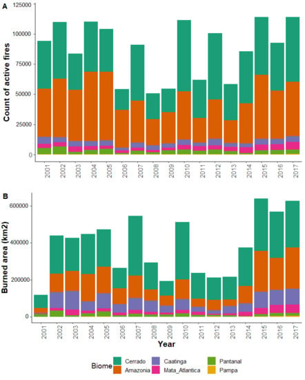
The 2017 fire season in Brazil recorded some of the highest values of burned area (628,000 km2) and numbers of active fires (114,217) since 2001, when the record-keeping began [28] (Figure 1). While the number of active fires per year in the Amazon and Cerrado remained high and similar to previous years (Figure 1A), the mean annual burned area increased significantly (2-ways ANOVA: F = 2.699, p = 0.027) in both biomes during the past three years (Figure 1B). The mean annual burned area in the Amazon increased four-fold from 2011–2014 to 2015–2017 (from 57,206 ± 25,334 to 205,236 ± 28,113 km2). In the Cerrado, the burned area almost doubled during the same period: From 147,991 ± 4202 to 262,114 ± 19,026 km2. That expansion of the annual burned area was mainly caused by megafires.
3. Fires in the Cerrado
The Cerrado is dominated by savannas, whose biota and ecological processes have been shaped by fire for at least four million years [29]; therefore, plants and animals show several fire-related traits [30]. This savanna region comprises a mosaic of different physiognomies—from grasslands (e.g., campo limpo) to typical savannas (e.g., campo sujo, campo cerrado, cerrado sensu stricto) and forest (cerradão)—which are related to fire frequency, among other factors. Fire opens up the physiognomy by killing young arboreal individuals [31]; it then tends to be more frequent in the more open physiognomies, while cerradão rarely burns [32]. Natural fires in the Cerrado usually occur in the wet season or in the seasonal transition months, commonly with a frequency of three to eight years, and are caused by lightning strikes [30]. However, the fire regime has been altered by human activities. In the open physiognomies of the Cerrado used as native pastures, cattle ranchers burn the vegetation annually or biannually, during the period of feed shortage, to promote grass regrowth for the animals. Since this burning happens in the middle or at the end of the dry season, fires get hotter than the natural fires started by lightning in the seasonal transition months, because there is more dead biomass accumulated, which is also drier and leads to more intense and hotter fires [33]. Such cattle ranching fires, as well as fires used to burn remains of agricultural crops, greatly increase the risk of accidental fires in the protected areas (PAs) surrounded by farms and shorten the fire return interval [30,34]. Conversely, fire suppression has been a common policy in the Cerrado’s protected areas (PAs) [35,36,37] and enormous effort is concentrated in the dry season to fight fires within the PAs, which may postpone fire, encourage hot wildfires and lengthen the fire return interval. Fire suppression increases the fuel load, thus enhancing the probability of more intense and severe wildfires; consequently, nutrient cycling slows down, fire-prone species become scarce, invasive species may establish and alterations throughout the entire community may lead to biodiversity loss [35,38,39]. Therefore, as in other fire-prone ecosystems, the disruption of the natural relationship between climate, vegetation and fire has profoundly changed the Cerrado environment and biota.
4. The “Zero-Fire” Policy in the Cerrado and Its Consequences
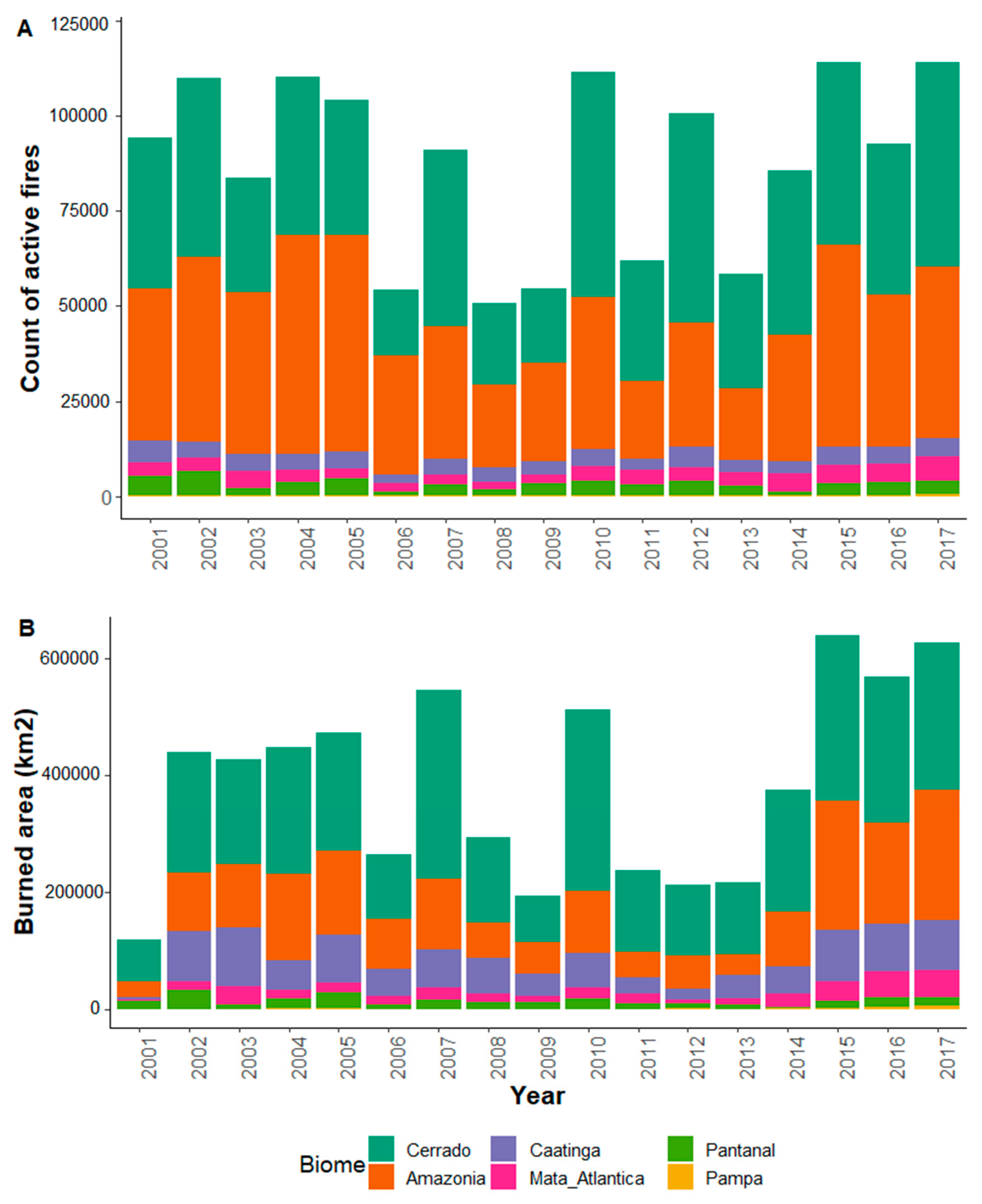
The “zero-fire” policy is common in the Cerrado PAs, where fire has been extinguished or prevented, especially by the establishment of firebreaks [35]. It is our main goal in this paper to show, using case studies, that the zero-fire policy is not adequate in most Cerrado PAs—especially those dominated by open physiognomies—where this policy has led to wildfires that have consumed vast areas. In the dry season, wildfire is a major problem faced by PA managers and neighboring areas. The Serra do Cipó National Park (Figure 2) is one example. From 1984 to 2014, ca. 90% of the park area burned at least once and most fires were human-driven [40]. Although the number of fires per year and the fire frequency decreased after excluding cattle from the park, the total burned area remained constant [41]. The same pattern was observed in Serra da Canastra National Park (Figure 2). From 2001 to 2015, at least 30% of the park burned annually and ca. 70% of the total area burned every two to three years, mostly due to land use conflicts among neighboring communities [37]. In 2010, a megafire burned more than 50% of the park [37]. The year 2010 was characterized by one of the strongest droughts in the century related to the Atlantic Multidecadal Oscillation index, which also contributed to the high frequency of fires in the Amazon [42]. Thus, the drought of that year, associated to the long period of biomass accumulation caused by the zero-fire policy, possibly led to huge fires in 2010. Moreover, social conflicts generated by an incompatibility between the official policy of fire exclusion and the local people’s goals and desires also influenced the high occurrence of wildfires in the Cerrado in that year.
We will examine in more detail the fire patterns from 2010 to 2017 in two Cerrado PAs, the Chapada dos Veadeiros National Park (CVNP) and the Estação Ecológica Serra Geral do Tocantins (ESEC-SGT, Figure 2). These two examples were chosen because an Integrated Fire Management (IFM) strategy was adopted at ESEC-SGT in 2014, and on a very small scale at CVNP in 2017.
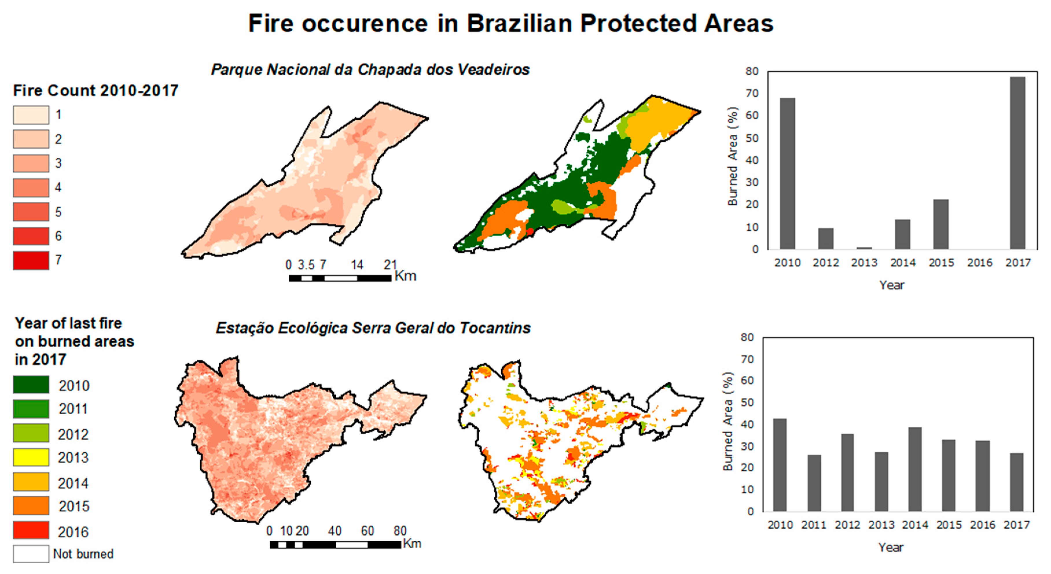
In 2017, a megafire burned 504 km2 (78%) of the CVNP, seven years after a previous megafire burned 68% of the park (Figure 3). According to Alvarado et al. [40], negative rainfall anomalies during the fire season (May–October) can increase the burned area. In the region of the CVNP and the Reserva Natural Serra do Tombador (RNST), rains usually start at the end of September to beginning of October. However, in 2017 the dry season extended until mid-end of October, leading to a longer dry season. The regular rainfall began only in the end of October, which extinguished naturally fire in several areas and helped local firefighters to control this megafire event. Although in 2017 the number of individual fire scars detected from MODIS satellite images was lower, while the mean fire size was greater (Figure 4A). CVNP started to implement the Integrated Fire Management (IFM) strategy in 2017, but the park’s managed area was still not enough to prevent the 2017 megafire. Another example is the Reserva Natural Serra do Tombador (RNST), 85% of which was burned in October 2017 (Claudio Henschel, personal communication) and wildfires were only controlled also when regular rains started (end of October, Juraci Amorim, personal communication). Wildfires in 2001 and 2007 burned, respectively, 45% and 51% of the RNST [43]. The accumulated biomass was two-fold higher in areas without fire for seven years and three-fold higher in areas without fire for 12 years (Zanzarini, unpublished data). The amount of dead biomass tends to increase with a longer fire return interval [41] and with an abundance of invasive grasses, which produce much biomass and significantly increase the fuel load [44], leading to more intense fires [45]. Therefore, we believe that the high amount of accumulated fuel due to the zero-fire policy in the RNST was the main reason for the megafires.
A contrasting example is the Estação Ecológica Serra Geral do Tocantins (ESEC-SGT), whose fire management history has inspired paradigm shifts on fire management. The ESEC-SGT was one of the most burned Cerrado PAs. From 2001 to 2014, fire management within the ESEC-SGT was focused on fire suppression, but decisions were not based on scientific advice or local communities’ knowledge and needs. In 2014, an IFM based on prescribed burns was implemented and led to immediate changes in the fire regime between 2014 and 2016 [46]. The IFM approach was to burn patches of open physiognomies from the end of the wet season to the middle of the dry season in order to form a patchy mosaic of areas burned in different years. The prescribed burnings were conducted in May, when fuel moisture was higher and the fires would be cool and easier to control [33,39], and covered an area of ca. 500 ha in the ESEC-SGT. In the following years, the areas for prescribed burnings were extended: 49,000 ha in 2015; 94,000 ha in 2016 and 93,000 ha in 2017. Prescribed burnings were usually carried out no later than July to keep fires cool or mild. From August onwards, wildfires were controlled to protect some fire-sensitive vegetation types (e.g., gallery forests). The previously managed areas also acted as firebreaks.
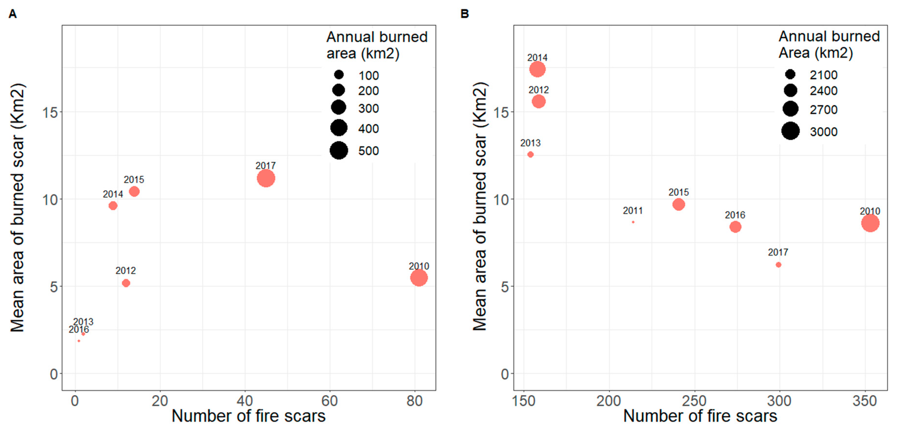
Comparing the ESEC-SGT and CVNP in the period 2010–2017, the first PA shows a pattern of large-area fires before the IFM implementation, in either a small number (2014) or a great number (2010), on a four-year return interval (since fires from 2011–2013 were very few or very small, Figure 4). However, after the IFM implementation (2014), a pattern of several smaller fires began with a tendency of reduction in the PA’s total burned area (from 2207.7 ± 515.5 km2 prior to 2015 to 2178.6 ± 238.5 km2 after 2015) and a significant reduction in the mean size of fire scars (from 12.5 ± 4.0 km2 prior to 2015 to 8.1 ± 1.7 km2 after 2015, one-way ANOVA, F = 9.125, P = 0.0026, Figure 4B). Before 2015, the maximum scar size ranged between 206.9 to 517.7 km2; after that year, it decreased to 76.2–169.2 km2. The megafire events of 2017 did not severely affect ESEC-SGT (Figure 3), probably as a result of the four years of consistent IFM. The total burned area in 2017 was the smallest since the implementation of the IFM (chi2 test, p ≤ 0.0001) at the ESEC-SGT (Figure 3 and Figure 4B). In the CVNP, however, a different pattern was observed after 2015, with high fuel buildup in the years 2014–2016 (due to firefighting policy) and a megafire in 2017, showing the greatest total burned area from 2010–2017 (chi2 test, p ≤ 0.0001, Figure 3 and Figure 4A).
5. To Burn or Let It Burn?
The trend of fire banishment in nature preserves was associated with the perception that fire is essentially destructive and disruptive of ecosystem stability, a degradation agent [47]. Because of this, fire suppression was the rule in the North American, Australian and South African PAs until the 1960s. However, the difficulty in controlling megafires resulting from biomass accumulation and the advance of ecological knowledge convinced the authorities that fire was actually beneficial and necessary, and the policy of fire exclusion then shifted to one of fire management in these countries [48,49,50].
Management focused on fire suppression still prevails in PAs that aim to protect the Cerrado vegetation. Consequently, local managers and fire brigades spend considerable effort, time and money to establish firebreaks or to extinguish fires.
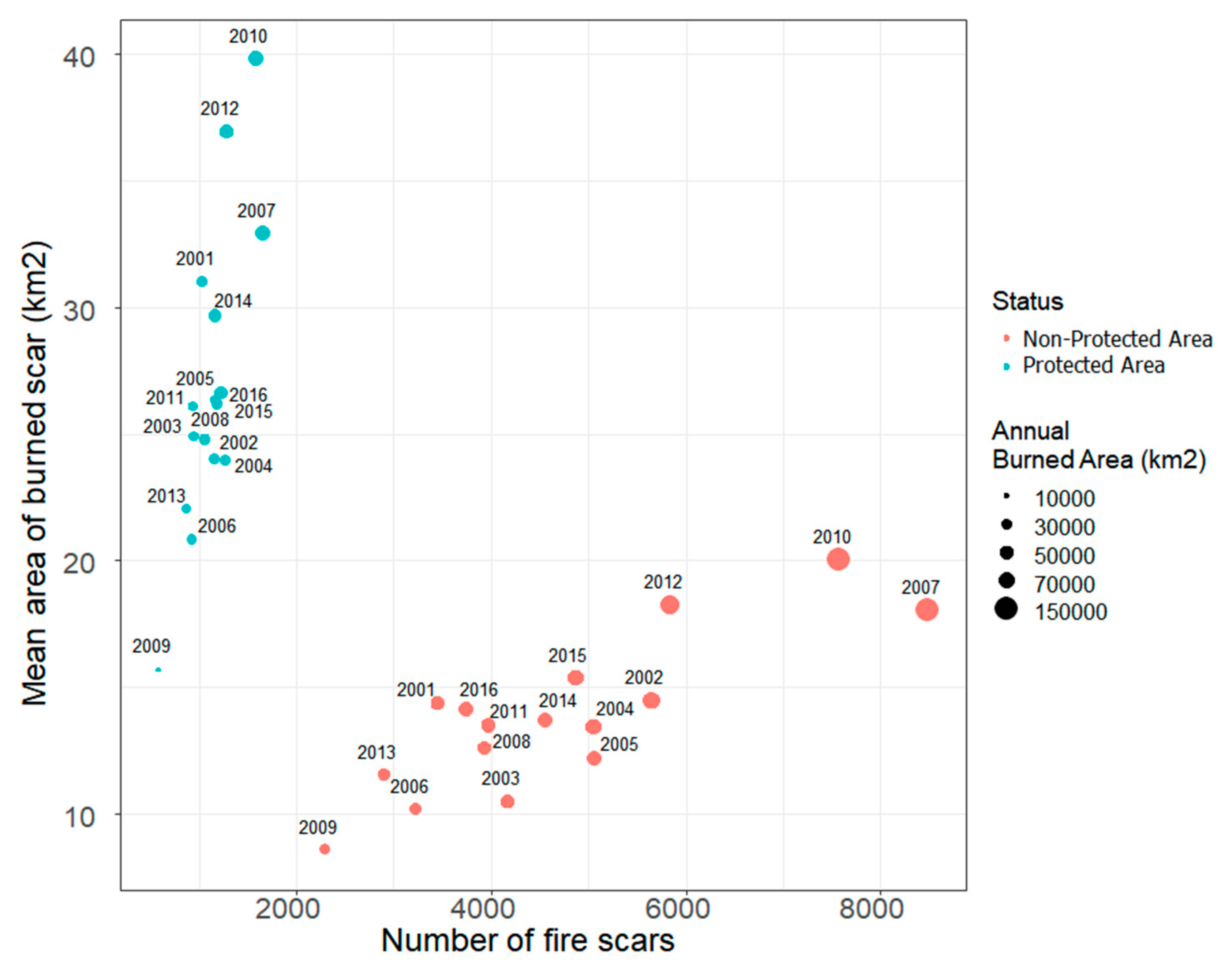
A comparison of the number of fire scars per year and the average area of scars between the Cerrado PAs with a fire-exclusion policy and the areas not protected from fire (Figure 5) reveals distinct patterns: Areas under fire-exclusion policy usually have fewer but larger fire scars. In the areas not protected from fire, local people increase landscape fragmentation through roads and other human land uses (e.g., houses, crop fields); they may use fire as a management tool for cattle ranching and thus decrease vegetation biomass [51]. Because of this, the area of fire scars was always smaller in the non-protected areas (mean = 14.7 km2), independent of the year (except for 2009), compared to the protected areas (mean = 28.04 km2) (Figure 5).
Taking advantage of the lessons learned from ESEC-SGT and some other examples, several Cerrado National Parks (e.g. Chapada dos Veadeiros, Chapada dos Guimarães, Serra do Cipó, Serra da Canastra, Sempre-Vivas, Araguaia, Nascentes do Rio Parnaíba and Campos Amazônicos) have recently started to use (or are planning to use) prescribed burnings as part of IFM to decrease fuel load and avoid megafires. Some of them also experienced megafires in 2017, even though they had begun to implement IFM on a small scale. It is important to point out that, although several PAs are starting to use IFM, results may differ among them due to several factors, such as the PA size, its geographic location and isolation, human density and activities/pressures in the surroundings, accumulated fuel, operational capacity (firefighters, equipment), training of the local fire brigade, and local community support.
Policymakers and actors involved in management plans must be concerned about the future scenarios under climate change, for which higher wildfire risk—and thus more human and ecological costs—are predicted [52]. In the last decades, fire weather season has been increasing in length, mostly in the tropical biomes [53]. Consequently, fire-related emissions also tend to increase [54]. With that in mind, human activities must be included in the discussion about fire management and policy.
Wildfires are difficult to predict with certainty because we still do not know enough about fire causes, effects and feedbacks [11,18]. Unless we assume that fire will occur sooner or later in some areas and take preventive actions, we will continue to witness catastrophic events and struggle against them. The integration of paleoecological data about past fire regimes could be useful for conservation [57], although that kind of data is still lacking for the Cerrado. Therefore, we suggest moving from a top-down policy approach to one based on the design of adequate measures for the local context. The current experience of implementing IFM in some Cerrado Protected Areas is a good starting point. Greater knowledge on landscape vulnerability and fire impacts and the lessons learned from past experiences must be used to ameliorate wildfire risk assessment, support pro-active fire management and, ultimately, avoid megafires. The approach that is being used to develop the IFM protocols is based on the current national and international scientific knowledge on fire management [46]. To a greater or lesser degree, they attempt to incorporate traditional knowledge, especially when established for indigenous territories. For example, in the Xerente Indigenous Territory, a detailed study was carried out to incorporate indigenous knowledge on IFM procedures [58].
Finally, we believe that local managers of Cerrado PAs should think about using fire as a tool to not only prevent megafires but also maintain Cerrado physiognomies (mostly open savannas and grasslands), ecological processes and biodiversity. We should evaluate the practice of patch mosaic burning (a traditional use of fire by local people) working on the assumption that promoting pyrodiversity can increase biodiversity. Changing paradigms is difficult, but the example of the ESEC-SGT is promising and demonstrates the possible benefits for both ecosystems and the local managers who have to deal with the threat of megafires every year. Local social conflicts might also be resolved.
Author Contributions
A.F. conceived the idea; A.F. and V.R.P. wrote the manuscript with help from the other authors. S.T.A. analyzed the data and prepared the figures. All authors contributed to the drafts and gave final approval for publication.
Funding
This research was funded by Fundação de Amparo à Pesquisa do Estado de São Paulo (2015/06743-0) and Fundação Grupo O Boticário (0153_2011_PR). A.F. and V.R.P. received financial support from Conselho Nacional de Desenvolvimento Científico e Tecnológico (306170/2015-9; 305253/2015-8), S.T.A. received a postdoctoral grant from Fundação de Amparo à Pesquisa do Estado de São Paulo (2014/12728-1).
Acknowledgments
We thank the Instituto Chico Mendes de Conservação da Biodiversidade (ICMBio) and the managers from the Estação Ecológica Serra Geral do Tocantins for providing information on fire management activities. We also thank Megan King for the English review.
Conflicts of Interest
The authors declare no conflict of interest. The funders had no role in the design of the study; in the collection, analyses, or interpretation of data; in the writing of the manuscript, or in the decision to publish the results.
References
- Bond, W.J.; Scott, A.C. Fire and the spread of flowering plants in the Cretaceous. New Phytol. 2010, 188, 1137–1150. [Google Scholar] [CrossRef] [PubMed] [Green Version]
- Bond, W.J.W.; Keeley, J.J.E. Fire as a global “herbivore”: The ecology and evolution of flammable ecosystems. Trends Ecol. Evol. 2005, 20, 387–394. [Google Scholar] [CrossRef]
- Hantson, S.; Pueyo, S.; Chuvieco, E. Global fire size distribution is driven by human impact and climate. Glob. Ecol. Biogeogr. 2015, 24, 77–86. [Google Scholar] [CrossRef]
- Roebroeks, W.; Villa, P. On the earliest evidence for habitual use of fire in Europe. Proc. Natl. Acad. Sci. USA 2011, 108, 5209–5214. [Google Scholar] [CrossRef] [Green Version]
- Bowman, D.M.J.S.; Balch, J.; Artaxo, P.; Bond, W.J.; Cochrane, M.A.; D’Antonio, C.M.; Defries, R.; Johnston, F.H.; Keeley, J.E.; Krawchuk, M.A.; et al. The human dimension of fire regimes on Earth. J. Biogeogr. 2011, 38, 2223–2236. [Google Scholar] [CrossRef] [PubMed] [Green Version]
- Pechony, O.; Shindell, D.T. Driving forces of global wildfires over the past millennium and the forthcoming century. Proc. Natl. Acad. Sci. USA 2010, 107, 19167–19170. [Google Scholar] [CrossRef] [PubMed] [Green Version]
- Balch, J.K.; Bradley, B.A.; Abatzoglou, J.T.; Nagy, R.C.; Fusco, E.J.; Mahood, A.L. Human-started wildfires expand the fire niche across the United States. Proc. Natl. Acad. Sci. USA 2017, 114, 2946–2951. [Google Scholar] [CrossRef]
- Pivello, V. The use of fire in the cerrado and Amazonian rainforests of Brazil: Past and present. Fire Ecol. 2011, 7, 24–39. [Google Scholar] [CrossRef]
- Syphard, A.D.; Radeloff, V.C.; Keeley, J.E.; Hawbaker, T.J.; Clayton, M.K.; Stewart, S.I.; Hammer, R.B. Human influence on california fire regimes. Ecol. Appl. 2007, 17, 1388–1402. [Google Scholar] [CrossRef]
- Archibald, S. Managing the human component of fire regimes: Lessons from Africa. Philos. Trans. R. Soc. Lond. B Biol. Sci. 2016, 371, 20150346. [Google Scholar] [CrossRef]
- Bowman, D.M.J.S.; Balch, J.K.; Artaxo, P.; Bond, W.J.; Carlson, J.M.; Cochrane, M.A.; D’Antonio, C.M.; Defries, R.S.; Doyle, J.C.; Harrison, S.P.; et al. Fire in the Earth system. Science 2009, 324, 481–484. [Google Scholar] [CrossRef] [PubMed]
- Ferreira-Leite, F.; Ganho, N.; Bento-Gonçalves, A.; Botelho, F. Iberian atmospheric dynamics and large forest fires in mainland Portugal. Agric. For. Meteorol. 2017, 247, 551–559. [Google Scholar] [CrossRef]
- Scott, A.C.; Bowman, D.M.J.S.; Bond, W.J.; Pyne, S.J.; Alexander, M.E. Fire on Earth: An Introduction; Wiley-Blackwell: Hoboken, NJ, USA, 2014; ISBN 978-1-119-95357-9. [Google Scholar]
- Archibald, S.; Lehmann, C.E.R.; Gomez-Dans, J.L.; Bradstock, R.A. Defining pyromes and global syndromes of fire regimes. Proc. Natl. Acad. Sci. USA 2013, 110, 6442–6447. [Google Scholar] [CrossRef] [Green Version]
- Schlosser, J.S.; Braun, R.A.; Bradley, T.; Dadashazar, H.; MacDonald, A.B.; Aldahif, A.A.; Aghdam, M.A.; Mardi, A.H.; Xian, P.; Sorooshian, A. Analysis of aerosol composition data for western United States wildfires between 2005 and 2015: Dust emissions, chloride depletion, and most enhanced aerosol constituents Joseph. J. Geophys. Res. Atmos. 2017, 122, 8951–8966. [Google Scholar] [CrossRef] [PubMed]
- Vicente, A.; Calvo, A.; Fernandes, A.P.; Nunes, T.; Monteiro, C.; Pio, C.; Alves, C. Hydrocarbons in particulate samples from wildfire events in central Portugal in summer 2010. J. Environ. Sci. (China) 2017, 53, 122–131. [Google Scholar] [CrossRef] [PubMed]
- Gill, A.M.; Stephens, S.L.; Cary, G.J. The worldwide “wildfire” problem. Ecol. Appl. 2013, 23, 438–454. [Google Scholar] [CrossRef] [PubMed]
- Benali, A.; Sá, A.C.L.; Ervilha, A.R.; Trigo, R.M.; Fernandes, P.M.; Pereira, J.M.C. Fire spread predictions: Sweeping uncertainty under the rug. Sci. Total Environ. 2017, 592, 187–196. [Google Scholar] [CrossRef]
- Moritz, M.A.; Batllori, E.; Bradstock, R.A.; Gill, A.M.; Handmer, J.; Hessburg, P.F.; Leonard, J.; McCaffrey, S.; Odion, D.C.; Schoennagel, T.; et al. Learning to coexist with wildfire. Nature 2014, 515, 58–66. [Google Scholar] [CrossRef] [PubMed]
- Balch, J.; Schoennagel, T.; Williams, A.; Abatzoglou, J.; Cattau, M.; Mietkiewicz, N.; St. Denis, L. Switching on the Big Burn of 2017. Fire 2018, 1, 17. [Google Scholar] [CrossRef]
- National Interagency Fire Center Total Wildland Fires and Acres (1960–2017). Available online: https://www.nifc.gov/fireInfo/fireInfo_main.html (accessed on 20 July 2001).
- California Department of Forestry and Fire Protection Top 20 Deadliest California Wildfires. Available online: https://calfire.ca.gov/communications/downloads/fact_sheets/Top20_Deadliest.pdf (accessed on 20 January 2018).
- ICNF 10.° Relatório Provisório de Incêndios Florestais. Available online: http://www2.icnf.pt/portal/florestas/dfci/Resource/doc/rel/2017/10-rel-prov-1jan-31out-2017.pdf (accessed on 10 April 2018).
- ANPC Autoridade Nacional de Protecção Civil. Available online: http://www.prociv.pt/pt-pt/Paginas/default.aspx (accessed on 20 August 2005).
- MAPAMA Los Incendios Forestales en España—1 enero a 31 Diciembre 2017 Avance Informativo. Available online: http://www.mapama.gob.es/es/desarrollo-rural/estadisticas/iiff_2017_def_tcm30-446071.pdf (accessed on 4 January 2018).
- Fernandes, P.M.; Barros, A.M.G.; Pinto, A.; Santos, J.A. Characteristics and controls of extremely large wildfires in the western Mediterranean Basin. J. Geophys. Res. Biogeosciences 2016, 121, 2141–2157. [Google Scholar] [CrossRef]
- Iriarte-Goñi, I.; Ayuda, M.-I. Should Forest Transition Theory include effects on forest fires? The case of Spain in the second half of the twentieth century. Land Use Policy 2018, 76, 789–797. [Google Scholar] [CrossRef]
- Instituto Nacional de Pesquisas Espaciais Portal do Monitoramento de Queimadas e Incêndios. Available online: http://www.inpe.br/queimadas (accessed on 15 March 2018).
- Simon, M.F.; Grether, R.; de Queiroz, L.P.; Skema, C.; Pennington, R.T.; Hughes, C.E.; Queiroz, L.P. Recent assembly of the Cerrado, a neotropical plant diversity hotspot, by in situ evolution of adaptations to fire. Proc. Natl. Acad. Sci. USA 2009, 106, 20359–20364. [Google Scholar] [CrossRef] [PubMed] [Green Version]
- Coutinho, L.M. Ecological effects of fire in Brazilian Cerrado. In Ecology of Tropical Savannas; Huntley, B.J., Walker, B.H., Eds.; Springer: Berlin, Germany, 1982; pp. 273–291. [Google Scholar]
- Miranda, H.S.; Sato, M.N.; Neto, W.N.; Aires, F.S. Fires in the Cerrado, the Brazilian savanna. In Tropical Fire Ecology: Climate Change, Land Use and Ecosystem Dynamics; Cochrane, M.A., Ed.; Springer-Praxis: Heidelberg, Germany, 2009; pp. 427–450. [Google Scholar]
- Coutinho, L.M. O conceito de cerrado. Rev. Bras. Bot. 1978, 1, 17–23. [Google Scholar]
- Rissi, M.N.; Baeza, M.J.; Gorgone-Barbosa, E.; Zupo, T.; Fidelis, A. Does season affect fire behaviour in the Cerrado? Int. J. Wildl. Fire 2017, 26, 427–433. [Google Scholar] [CrossRef]
- Ramos-Neto, M.B.; Pivello, V.R. Lightning fires in a Brazilian savanna national park: Rethinking management strategies. Environ. Manag. 2000, 26, 675–684. [Google Scholar] [CrossRef] [PubMed]
- Durigan, G.; Ratter, J.A. The need for a consistent fire policy for Cerrado conservation. J. Appl. Ecol. 2016, 53, 11–15. [Google Scholar] [CrossRef]
- Fidelis, A.; Pivello, V. Deve-se usar o fogo como instrumento de manejo no Cerrado e Campos Sulinos? Biodiversidade Bras. 2011, 1, 12–25. [Google Scholar]
- Batista, E.K.L.; Russell-Smith, J.; França, H.; Figueira, J.E.C. An evaluation of contemporary savanna fire regimes in the Canastra National Park, Brazil: Outcomes of fire suppression policies. J. Environ. Manag. 2018, 205, 40–49. [Google Scholar] [CrossRef]
- Abreu, R.C.R.; Hoffmann, W.A.; Vasconcelos, H.L.; Pilon, N.A.; Rossatto, D.R.; Durigan, G. The biodiversity cost of carbon sequestration in tropical savanna. Sci. Adv. 2017, 3, 1–8. [Google Scholar] [CrossRef]
- Pivello, V.R.; Norton, G.A. Firetool: An expert system for the use of prescribed fires in Brazilian savannas. J. Appl. Ecol. 1996, 33, 348–356. [Google Scholar] [CrossRef]
- Alvarado, S.T.; Fornazari, T.; Cóstola, A.; Morellato, L.P.C.; Silva, T.S.F. Drivers of fire occurrence in a mountainous Brazilian cerrado savanna: Tracking long-term fire regimes using remote sensing. Ecol. Indic. 2017, 78, 270–281. [Google Scholar] [CrossRef]
- Alvarado, S.T.; Silva, T.S.F.; Archibald, S. Management impacts on fire occurrence: A comparison of fire regimes of African and South American tropical savannas in different protected areas. J. Environ. Manag. 2018, 218, 79–87. [Google Scholar] [CrossRef] [PubMed]
- Aragão, L.E.O.C.; Anderson, L.O.; Fonseca, M.G.; Rosan, T.M.; Vedovato, L.B.; Wagner, F.H.; Silva, C.V.J.; Silva Junior, C.H.L.; Arai, E.; Aguiar, A.P.; et al. 21st Century drought-related fires counteract the decline of Amazon deforestation carbon emissions. Nat. Commun. 2018, 9, 536. [Google Scholar] [CrossRef] [PubMed]
- Daldegan, G.; de Carvalho, O.; Guimarães, R.; Gomes, R.; Ribeiro, F.; McManus, C. Spatial Patterns of Fire Recurrence Using Remote Sensing and GIS in the Brazilian Savanna: Serra do Tombador Nature Reserve, Brazil. Remote Sens. 2014, 6, 9873–9894. [Google Scholar] [CrossRef] [Green Version]
- Damasceno, G.; Souza, L.; Pivello, V.R.; Gorgone-Barbosa, E.; Giroldo, P.Z.; Fidelis, A. Impact of invasive grasses on Cerrado under natural regeneration. Biol. Invasions 2018, 1–9. [Google Scholar] [CrossRef]
- Gorgone-Barbosa, E.; Pivello, V.R.; Bautista, S.; Zupo, T.; Rissi, M.N.; Fidelis, A. How can an invasive grass affect fire behavior in a tropical savanna? A community and individual plant level approach. Biol. Invasions 2015, 17, 423–431. [Google Scholar] [CrossRef]
- Schmidt, I.B.; Moura, L.C.; Ferreira, M.C.; Eloy, L.; Sampaio, A.B.; Dias, P.A.; Berlinck, C.N. Fire management in the Brazilian savanna: First steps and the way forward. J. Appl. Ecol. 2018, 55, 2094–2101. [Google Scholar] [CrossRef] [Green Version]
- Pausas, J.G.; Bond, W.J. Humboldt and the reinvention of nature. J. Ecol. 2018. [Google Scholar] [CrossRef]
- Bond, W.J.; Archibald, S. Confronting complexity: Fire policy choices in South African savanna parks. Int. J. Wildl. Fire 2003, 12, 381–389. [Google Scholar] [CrossRef]
- Elfring, C. Yellowstone—Fire Storm over Fire Management. Bioscience 1989, 39, 667–672. [Google Scholar] [CrossRef]
- Van Wilgen, B.W.W.; Govender, N.; Biggs, H.C.C.; Ntsala, D.; Funda, X.N.N. Response of Savanna Fire Regimes to Changing Fire-Management Policies in a Large African National Park. Conserv. Biol. 2004, 18, 1533–1540. [Google Scholar] [CrossRef]
- Andela, N.; van der Werf, G.R. Recent trends in African fires driven by cropland expansion and El Niño to La Niña transition. Nat. Clim. Chang. 2014, 4, 791e–795e. [Google Scholar] [CrossRef]
- Syphard, A.D.; Keeley, J.E.; Pfaff, A.H.; Ferschweiler, K.; Franklin, J. Human presence diminishes the importance of climate in driving fire activity across the United States. Proc. Natl. Acad. Sci. USA 2017, 114, 13750–13755. [Google Scholar] [CrossRef] [PubMed]
- Jolly, W.M.; Cochrane, M.A.; Freeborn, P.H.; Holden, Z.A.; Brown, T.J.; Williamson, G.J.; Bowman, D.M.J.S. Climate-induced variations in global wildfire danger from 1979 to 2013. Nat. Commun. 2015, 6, 7537. [Google Scholar] [CrossRef] [PubMed] [Green Version]
- Krawchuk, M.A.; Moritz, M.A.; Parisien, M.A.; Van Dorn, J.; Hayhoe, K. Global pyrogeography: The current and future distribution of wildfire. PLoS ONE 2009, 4, e5102. [Google Scholar] [CrossRef] [PubMed]
- IUCN, UNEP-WCMC. The World Database on Protected Areas (WDPA); UNEP-WCMC: Cambridge, UK, 2017; Available online: www.protectedplanet.net (accessed on 30 October 2017).
- Laurent, P.; Mouillot, F.; Yue, C.; Ciais, P.; Moreno, M.V.; Nogueira, J.M.P. FRY, a global database of fire patch functional traits derived from space-borne burned area products. Sci. Data 2018, 5, 180132. [Google Scholar] [CrossRef]
- Gillson, L.; Marchant, R. From myopia to clarity: Sharpening the focus of ecosystem management through the lens of palaeoecology. Trends Ecol. Evol. 2014, 29, 317–325. [Google Scholar] [CrossRef]
- Mistry, J.; Bilbao, B.A.; Berardi, A. Community owned solutions for fire management in tropical ecosystems: Case studies from Indigenous communities of South America. Philos. Trans. R. Soc. B Biol. Sci. 2016, 371, 20150174. [Google Scholar] [CrossRef]
Figure 1.
Annual active fires (A) and burned area (B) for the six Brazilian biomes from 2001 to 2017 (Source: [28]).
Figure 1.
Annual active fires (A) and burned area (B) for the six Brazilian biomes from 2001 to 2017 (Source: [28]).

Figure 2.
Location and surroundings of the Cerrado protected areas: Chapada dos Veadeiros National Park (CVNP), Reserva Natural Serra do Tombador (RNST), Estação Ecológica Serra Geral do Tocantins (ESEC-SGT), Serra da Canastra National Park (SCaNP) and Serra do Cipó National Park (SCNP). Polygons in brighter green indicate the protected areas. Source (background image): Esri, DigitalGlobe, GeoEye, Earthstar Geographics, CNES/Airbus DS, USDA, USGS, AeroGRID, IGN and the GIS User Community.

Figure 3.
Fire counts in 2010–2017 for Chapada dos Veadeiros National Park and Estação Ecológica Serra Geral do Tocantins (left); time since last fire, only for the burned area in 2017 (middle); annual percentage of burned area in 2010–2017 (right).
Figure 3.
Fire counts in 2010–2017 for Chapada dos Veadeiros National Park and Estação Ecológica Serra Geral do Tocantins (left); time since last fire, only for the burned area in 2017 (middle); annual percentage of burned area in 2010–2017 (right).

Figure 4.
Relationship between the number of fire scars per year and the average area of scars in the Chapada dos Veadeiros National Park (A) and Estação Ecológica Serra Geral do Tocantins (B) (Source: DIMIF/ICMBio). (Burn scars were not detected for the CVNP in 2011).
Figure 4.
Relationship between the number of fire scars per year and the average area of scars in the Chapada dos Veadeiros National Park (A) and Estação Ecológica Serra Geral do Tocantins (B) (Source: DIMIF/ICMBio). (Burn scars were not detected for the CVNP in 2011).

Figure 5.
Relationship between the number of fire scars per year and the average extension of burn scars in protected and non-protected areas in the Cerrado between 2001 and 2016. Information about the protected status (protected/non-protected) comes from the World Database on Protected Areas (WDPA) [55]. Data source: FRY Global fire patch morphology database [56].

© 2018 by the authors. Licensee MDPI, Basel, Switzerland. This article is an open access article distributed under the terms and conditions of the Creative Commons Attribution (CC BY) license (http://creativecommons.org/licenses/by/4.0/).
Share and Cite
MDPI and ACS Style
Fidelis, A.; Alvarado, S.T.; Barradas, A.C.S.; Pivello, V.R. The Year 2017: Megafires and Management in the Cerrado. Fire 2018, 1, 49. https://0-doi-org.brum.beds.ac.uk/10.3390/fire1030049
AMA Style
Fidelis A, Alvarado ST, Barradas ACS, Pivello VR. The Year 2017: Megafires and Management in the Cerrado. Fire. 2018; 1(3):49. https://0-doi-org.brum.beds.ac.uk/10.3390/fire1030049
Chicago/Turabian StyleFidelis, Alessandra, Swanni T. Alvarado, Ana Carolina S. Barradas, and Vânia R. Pivello. 2018. "The Year 2017: Megafires and Management in the Cerrado" Fire 1, no. 3: 49. https://0-doi-org.brum.beds.ac.uk/10.3390/fire1030049