Is Anthropogenic Pyrodiversity Invisible in Paleofire Records?


1
Department of Anthropology, Southern Methodist University, Dallas, TX 75275, USA
2
School of Natural Sciences, University of Tasmania, Hobart, TAS 7001, Australia
*
Author to whom correspondence should be addressed.
Fire 2019, 2(3), 42; https://0-doi-org.brum.beds.ac.uk/10.3390/fire2030042
Submission received: 31 May 2019
/
Revised: 28 June 2019
/
Accepted: 16 July 2019
/
Published: 18 July 2019
(This article belongs to the Special Issue Land-Use and Fire around the World from the Past to the Present)
Abstract
:Paleofire studies frequently discount the impact of human activities in past fire regimes. Globally, we know that a common pattern of anthropogenic burning regimes is to burn many small patches at high frequency, thereby generating landscape heterogeneity. Is this type of anthropogenic pyrodiversity necessarily obscured in paleofire records because of fundamental limitations of those records? We evaluate this with a cellular automata model designed to replicate different fire regimes with identical fire rotations but different fire frequencies and patchiness. Our results indicate that high frequency patch burning can be identified in tree-ring records at relatively modest sampling intensities. However, standard methods that filter out fires represented by few trees systematically biases the records against patch burning. In simulated fire regime shifts, fading records, sample size, and the contrast between the shifted fire regimes all interact to make statistical identification of regime shifts challenging without other information. Recent studies indicate that integration of information from history, archaeology, or anthropology and paleofire data generate the most reliable inferences of anthropogenic patch burning and fire regime changes associated with cultural changes.
1. Introduction
The importance of anthropogenic burning in local and regional environmental histories of has been controversial. The difficulties of identifying anthropogenic influences in empirical fire histories has encouraged a speculative polemic, with some scholars arguing for continental-scale transformation by widespread anthropogenic burning [1,2] and others claiming that human activities were virtually irrelevant prior to the modern era [3,4,5]. The top-down influences of climate on fuel abundance and flammability coupled with the regularity of natural ignitions in many fire-prone continental environments has led some scholars to conclude that anthropogenic ignitions are of minor consequence historically, particularly when compared to the magnitude of change caused by fuel alterations in recent decades, including the effects of fire suppression [4,6,7]. These debates largely consider human influence with respect to the cumulative area burned per unit of time, in which only area burned and landscape-scale fire frequency matter.
Recent ethnographic [8] and other empirical studies of traditional burning practices [9,10] indicate that anthropogenic burning may have significant impacts on biodiversity and landscape heterogeneity by changing the grain of fire mosaics by frequently burning many small patches, even in environments that would otherwise experience frequent lightning ignited fires (≤20 year mean fire rotation). Despite nearly identical landscape-scale fire rotations, the ecological and evolutionary consequences of anthropogenic patch burning for biodiversity, fire severity, and climate vulnerability are significant [11,12]. Furthermore, human agency in the context of climate variation further complicates the assumption of climate-dominated fire regimes [13,14]. By shaping fire patterns, more than total area burned or fire rotation, human activities can dampen [12,15] or amplify [14,16] the effects of climate on fire regimes. Patch burning can be done explicitly to benefit game species, as some hunter-gatherers do [14,17], to reduce fire risk [18] or enhance horticultural productivity [19,20] as some farmers do, or to manipulate grazing patterns of livestock as some pastoralists and ranchers do [21,22,23]. Although the purposes, economies, and cultures vary, many uses of fire across the globe involve frequent burning of relatively small patches that generates landscape heterogeneity [11,24,25]. One of the key challenges in paleofire science is how to identify it, particularly on landscapes that already burn often.
Fire-scar dendrochronology [26] is the benchmark by which most fire history methods are evaluated, particularly in environments that experience decadal or sub-decadal fire return intervals and the species present are amenable to dendrochronological study [27,28,29,30,31]. Fire scars are created when the heat of a fire kills the cambium on part (but not all) of the basal circumference of a tree. After sloughing the overlying bark, subsequent growth by the tree begins to heal over this wound, facilitating the cross-dating of the fire-damaged ring. In some cases, the fire can be attributed to the portion of the growing season in which the damage was incurred, allowing the dendrochronologist to estimate fire seasonality as well [26,32]. Many trees never form fire scars, despite surviving many fires. However, once scarred, the thin protective bark along the margins of the scar and the abundance of resin that is present in the exposed wood increases the likelihood that an already scarred tree will record subsequent fires, although this too is affected by the time since last fire and the accumulation of fuels sufficient to allow fire to spread to the base of the tree. Thus, the presence of a fire-scar is clear evidence of a fire but the absence of a scar is ambiguous about whether or not a fire occurred [33]. Although there has been some criticism of the fire-scar record as overestimating the frequency of fire [34], robust assessments of sampling strategies [35,36,37] and limited evaluation of scar probability [33] indicate that the fire-scar record is likely conservative and may underrepresent actual fire history, rather than over-represent it.
These basic fire-scar methods have been used to assemble annually and seasonally resolved multi-century to multi-millennial fire histories in dry and mesic forests across the globe [16,38,39,40,41,42,43,44,45,46,47,48]. The frequency and synchrony of fire-scars across scales within regional studies has been used as evidence for the importance of extensive, spreading fires in these forests and, by extension, used to dismiss the significance of anthropogenic burning as a contributor to the historical ecology of these settings [7]. However, more than three decades ago, anthropologist Henry Lewis suggested that very high patch-specific fire frequencies that may have characterized some anthropogenic fire regimes, may be underrepresented in the fire-scar record because fuel loads may never be sufficient to produce or re-scar trees within a frequently burned patch [49]. Although this critique explicitly focused on hunter-gatherer burning, this concern may be equally valid for other forms of patch burning as well as fuel manipulation by farmers and pastoralists [50]. This critique has largely been unaddressed by fire historians, although the efforts to address the overrepresentation critiques have assembled evidence to suggest that Lewis’s concerns merit serious consideration.
Here, we consider whether or not the problem of identifying anthropogenic pyrodiversity and its consequences in paleofire records is tractable. How much of the problem is determined by underlying assumptions? How much is methodological? And how can paleofire scientists move forward with research that can account for and identify anthropogenic pyrodiversity when present? Although we focus on tree-ring records, the conceptual issues about identifying anthropogenic patch burning in landscapes that already burn frequently (e.g., savannas and grasslands) are broadly relevant to paleofire studies that employ other proxies.
2. Materials and Methods
To evaluate the potential for methodological barriers to the identification of anthropogenic impacts on fire patterns, we built a cellular automata model to replicate conventional fire-scar methods. On the basis of empirical research, we assume that a key feature of anthropogenic burning in many flammable environments is a decrease in the size of individual burn patches [10,11,12,51], and that this change in fire pattern promotes pyrodiversity by creating and sustaining landscape heterogeneity. Further, we assume that the probability of fire-scar formation is low on unscarred trees and that it varies on previously scarred trees with time since fire [33].
Although our cellular automata model is intended to be generalized and abstract, we used a tree density that roughly approximates 100 trees per hectare over a 400 hectare landscape, units that are reasonable for pre-settlement tree densities in surface fire regimes of Western North America and the size of a basic fire regime study site [52]. We use this rough approximation for estimating sampling intensity in samples per hectare below, although these numbers should be treated as rough approximations only. Depending upon the fire regime implemented (see Table 1), each cell may burn with a specified probability each year. Each of the four fire regimes has an identical mean fire rotation at the landscape scale (20-year rotation) but differ in the amount of area burned each time step.
We evaluated two experimental scenarios that allow us to ask the following questions:
- Experiment 1.
- Can standard fire-scar sampling strategies and intensities (samples per unit area) distinguish contrasting fire regimes with identical fire rotations using fire interval metrics? Are probabilistic or targeted sampling strategies better suited for characterizing these fire regimes? If possible, at what sampling intensity can this be achieved?
- Experiment 2.
- Can standard fire-scar methods identify fire regime changes from more frequent, small fires to less frequent, extensive fires using time-series metrics with a fading record problem (i.e., when sample depth diminishes further back in time)?
In our first experiment, we assumed quasi-real forest conditions in which tree mortality from fire and senescence removed trees from the record but unburned dead wood could be harvested for fire-scar analysis. We configured each version of the model with a stable fire regime that had an average fire rotation of 100% burnt every 20 years (Table 1 and Table A3). The final landscape (approximating 400 ha) of fire-scarred live and remnant dead wood were then sampled using (A) standard (targeted) strategies that focused on collecting those samples with the greatest number of scars, or (B) probabilistic strategies that collected scarred samples at random. Both strategies were implemented with a range of sampling intensities from as little as 10 samples (0.025 trees ha−1) to a complete census of all fire-scarred wood to generate a standard fire history measurement, the mean fire interval (MFI). The simulated tree-ring samples were unfiltered (all samples) and filtered for fires recorded in at least two samples (MFI2), at least 10% (MFI10%), and at least 25% (MFI25%) of all recording samples each year, as is conventionally done in most tree-ring analysis. These measures for each sampling design (probabilistic vs. targeted), intensity, and filter were compared to the MFI derived from the underlying landscape grid which served as a perfect recorder of the fire history for each simulation. Each fire regime was simulated 100 times for total of 400 simulations. Details of how we modeled tree growth, senescence, mortality, and fire scar probability can be found in Appendix A.
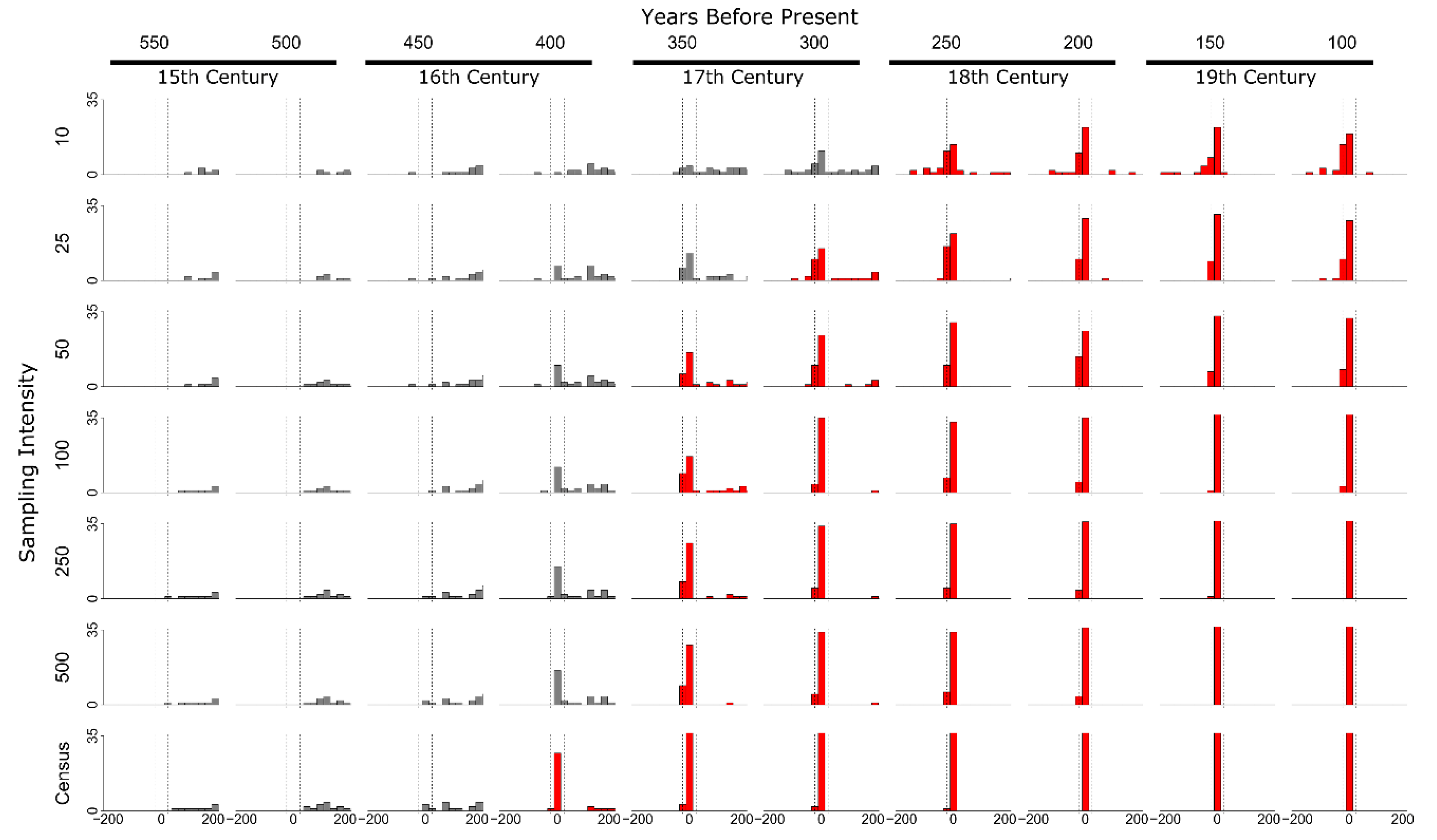
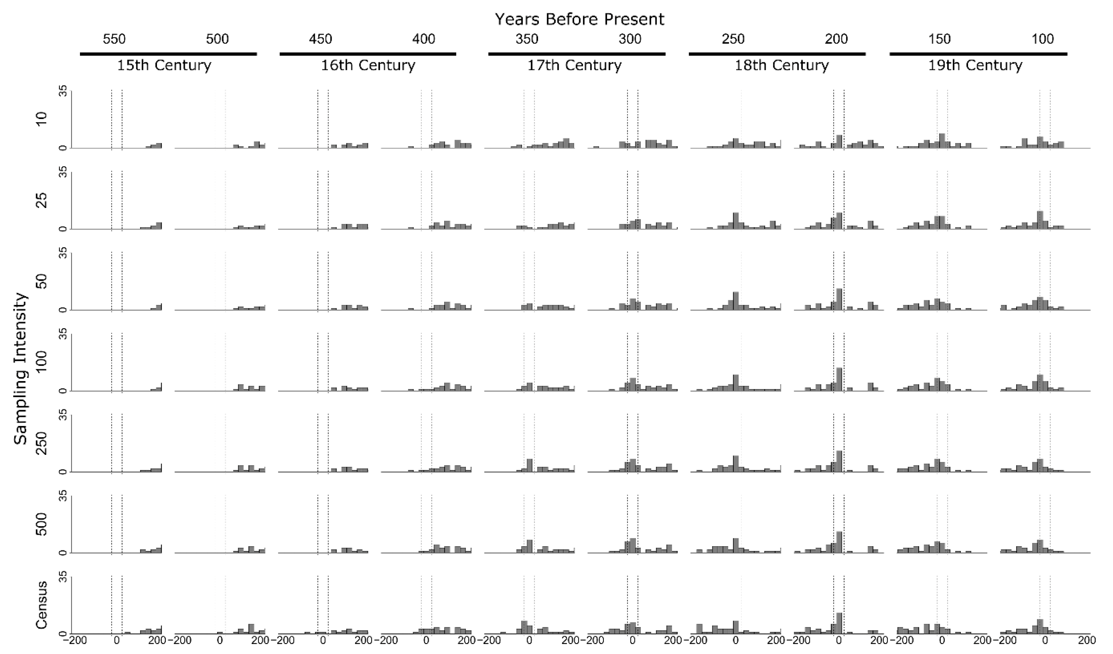
In our second experiment, we simulated a dynamic fire regime history that included two different fire regime-shift scenarios from small patchy fires to widespread fires: Scenario (1) from annual patch burning to bidecadal spreading fires, and Scenario (2) semidecadal patch burning to decadal spreading fires. Time series of the annual proportion of area burned (% of recording trees scarred, also referred to as synchrony) were recorded for each sampling intensity for each model run. On each run, we performed a regime shift analysis using a 30-year window moving t-test [53,54,55] on the fire synchrony data to evaluate the ability of regime shift analysis to correctly identify known regime shifts from frequent patch burning to less frequent extensive burning. To assess the impact of tree senescence and mortality (i.e., the fading record problem) on the accuracy of regime shift detection, we ran different scenarios in which the forced regime shift occurred at 50 year intervals between 100–500 model years “before present” (i.e., “present” is the end of the 700 year model run). Each fire regime scenario and regime shift point was run 40 times (400 runs for each regime shift scenario for a total of 800 simulations; see Table A3).
In this experiment, we evaluated the accuracy of “naïve” regime shift detection (i.e., with no other information besides the fire history data) relative to variably timed forced regime shifts. We structured this analysis by binning statistically inferred regime shift points in 25-year windows relative to the actual regime shift point. We considered successful, accurate regime shift detection to have occurred when the majority of sample runs (≥20 runs) were detected within 50 years of the forced regime shift.
3. Results
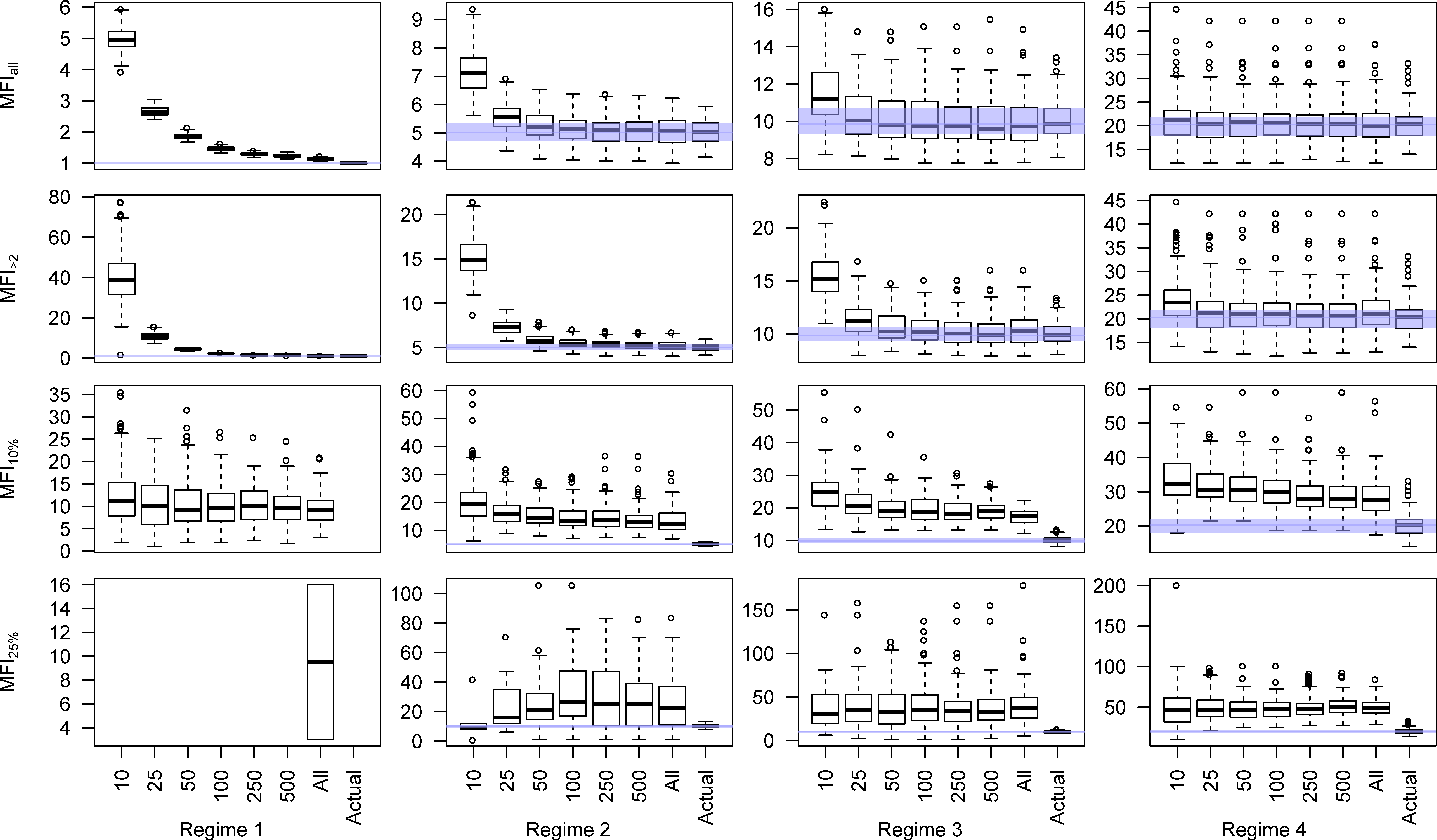
Our first experiment treated fire regimes discretely with equivalent records. The fading record was present but not a problem in this experiment as the regimes were compared against full simulations of the different modeling scenarios. The results of our simulations have important implications for ongoing debates on the validity of strategic sampling, by which old specimens with many fire-scars are preferentially sampled, compared with probabilistic sampling of tree-ring specimens. Contrary to early critiques, our results are very clear that targeted sampling is much more efficient and reliable at generating stable and accurate MFI values at relatively low sampling intensities for MFIall and MFI2 (as little as 0.125 samples ha−1) (Figure 1 and Figure 2). Furthermore, at relatively modest sampling intensities, each modeled fire regime is easily distinguished from one another using the unfiltered MFIall (Figure 3). Using targeted collection strategies, roughly 0.125 trees ha−1 (50 samples) are sufficient for relatively stable, discrete mean MFIall values for a particular fire regime, making these distinctions possible. Additionally, MFIall and MFI2 are the only fire frequency metrics that approach the true landscape MFI at any sampling intensity, and they do so at less than 100 samples, so long as a targeted strategy is employed (fewer than 0.25 trees ha−1).
The unfiltered MFIall is rarely used in dendroecological studies, however, for fear that it over-represents the importance of small fires. Consequently, the filtered MFI10% and MFI25% are more commonly used to infer fire frequency [37]. As our results indicate, the targeted sampling strategy stabilizes at smaller sample sizes relative to probabilistic sampling. However, even for spreading fire regimes (decadal and bidecadal spreading fires), in which the filters should be expected to best replicate the actual fire history, the filtered MFI10% and MFI25% metrics artificially and systematically underrepresent actual fire frequencies, returning MFI values that are roughly 150%–300% of their true value. Perhaps more problematically, at the 25% filter, the three fire regimes become more difficult to distinguish even with a complete census of fire-scarred material (Figure 3). The most liberal, but least utilized filter, MFI2, seems to provide the best compromise for removing uncorroborated, singleton fire-scars while still accurately describing the real fire history (Figure 1, second row) and distinguishing contrastive fire regimes (Figure 3) at modest sampling intensities (0.25 trees ha−1). This analysis suggests that if a study area is sufficiently well surveyed in advance, targeted sampling of roughly 0.25 trees ha−1 should be sufficient to distinguish fire regimes with different MFI. Rather than improving the representativeness of the fire-scar record, probabilistic sampling seems to dilute the sample, making it much more difficult to accurately describe landscape fire intervals with reasonable sample sizes (cf. [37]).
The filtering issue is an important one for considering methodological impacts on the visibility of anthropogenic pyrodiversity in the paleofire record. Filtering is justifiable for fire–climate analysis in order to isolate the years with the most widespread evidence for synchronized fire. However, our model suggests that this process is likely to systematically underrepresent fire frequency and overlooks exactly the kinds of evidence that might remain from anthropogenic patch burning. However, there are some interesting emergent properties of the filtered datasets that may provide evidence of patch burning. For example, although fires occur annually and burn only 5% of the 400ha plot each year in our annual patch burning scenario, the 10% filter consistently returns an estimated MFI10% around 10 years for this regime, regardless of sampling intensity and regardless of the fact that no fire year ever saw 10% area burned in these simulation runs (Figure 1, row 3, left column). None of the other fire regimes, including semidecadal patch burning and decadal spreading fires generate MFI10% that are that low. Therefore an MFI10% around 10 years or less may be evidence for annual patch burning. Furthermore, in the annual patch burning scenario, MFI25% values are only measurable with a complete census of fire-scar material, suggesting that another emergent property of annual patch burning is very low synchrony (<25%). This is a pattern that has been observed in tree-ring records where indigenous patch burning has been inferred in California [55] and New Mexico [15].
Our second experiment indicated both the importance of a fading record and the magnitude of contrast between the regimes when fire regimes shift. Histograms of statistically identified regime shifts are plotted relative to the known regime shift in Figure 4 and Figure 5. Distributions in red indicate simulations where the regime shift was accurately detected in the majority of the simulations. In no version of Scenario 2 (shift between semidecadal and decadal fires), in which the fire regime shift was relatively minor, was the forced regime shift detected accurately (Figure 5). Instead, moving t-tests regularly identified false positives up to 200 years before and after the forced regime shift. In Scenario 1, where the fire regime shift was higher contrast, relatively recent regime shifts were accurately detected at all sampling intensities but larger sample sizes were necessary to identify older regime shifts. The fading record problem interacts with sampling intensity to substantially impact how far in the past a regime shift could accurately be detected (Figure 4). This is obviously impacted by tree senescence and mortality. In our model mortality rates increased after 400 years, so the oldest regime shift that was detected accurately was 400 years BP, but this was only possible at maximum, census-level sampling intensity. False positives also occur in these t-tests but they are most common in smaller datasets and with older regime shifts. Since each case represents a particular simulation and reconstructed fire chronology, this suggests that these statistical inferences are most robust when they are corroborated by other fire chronologies to avoid type-I logical errors.
This highlights a second major methodological problem for identifying anthropogenic patch burning. If the differences in frequency between the anthropogenic regime and the non-anthropogenic regime are relatively small, then statistical analysis alone is unlikely to enable the identification of a regime shift between those two even if that regime shift occurred in the relatively recent past [18]. This is important because there is growing evidence that people are attracted to use fire as a landscape tool in already fire-prone environments precisely because they are so flammable [1,56]. This creates a fundamental ambiguity that pyrogeography has been wrestling with for decades. Without other information from anthropology, archaeology, or history to guide more targeted comparisons between particular periods of time, identifying anthropogenic pyrodiversity in the past can be difficult and frustratingly ambiguous. Even then, the fading record may make such an interdisciplinary analysis difficult or impossible if the shift from pre-colonial anthropogenic patch burning regime was replaced by a colonial one deep in the past.
4. Discussion
The spatial pattern and grain of the mosaic created by landscape fire has important consequences for food webs in the ecosystem in question [57]. Those impacts may be one of the primary reasons why traditional uses of fire generate pyrodiversity [11,12,15,17,20]. In addition to impacts on food webs, the spatial pattern of fires has impacts on fire sensitive species, fire refugia, and fire protection [11,18,58]. This is one of the primary reasons that understanding the mosaic of a particular fire regime is so important for contemporary land managers. In the absence of historical information on the spatial pattern of historical fire regimes, land managers are left to pick fire sizes arbitrarily [59]. The ability to infer the grain size of the historical fire mosaic would have important consequences for conservation and ecological restoration.
Research has demonstrated the ability of fire-scar dendrochronology to accurately map the extent of spreading surface fires [60,61]. At issue is the ability of the method to accurately identify high frequency patch burning from spreading surface fires when the fire rotation is identical. Two observations from our model have direct bearing on our primary questions. First, under ideal conditions, large sample sizes, and sufficient time depth, patch-burning regimes can be identified in tree-ring records. This is most easily identified when the fire-scar records are unfiltered. This runs counter to the tendency of most tree-ring studies, which filter the fire scar record to emphasize larger, spreading fires but in the process obscure critical data for documenting pyrodiversity, including anthropogenic fire mosaics.
Conventional fire history analysis is designed to focus on large fires that are recorded in synchronous scars across spatial scales [32]. This approach to filtering fire-scar data is useful for describing the important top-down role of climate but it leaves room for human activity only if there are obtrusive fire-climate anomalies. However, in multiple contexts, it is now clear that anthropogenic patch burning can enhance [14] or suppress fire-climate relationships [12,15]. Naïve analysis, that is to say analysis that only uses fire history data and not cultural data in an interdisciplinary approach is likely to miss the evidence for anthropogenic pyrodiversity. In other words, basic fire history methods may obscure the evidence for anthropogenic patch burning but it is not necessarily a problem of the fire-scar record. With a different set of assumptions and a methodology that looks at all fires in the record and utilizes interdisciplinary records of human land-use, we think anthropogenic pyrodiversity can be visible in the paleofire record.
We have this confidence because a number of recent studies have demonstrated what this might look like. In the dry conifer forests of the Sierra Nevada of California, Taylor and colleagues used fire synchrony (unfiltered) from a network of fire-scar localities to look for regime shifts using a moving t-test analogous to the one that we used for our model. This analysis statistically identified multiple likely regime shifts that were interpreted in light of California historic and anthropological records [55]. Here we suspect that the slightly longer MFI for their study area (MFI2 = 17.7) made the contrast between the indigenous patch burning regime (ca. 1600–1775 CE) and the other periods more readily identifiable in the statistical analysis. Nevertheless, as the analysis was informed by cultural and historical records, we suspect that the authors would have had a greater likelihood of identifying the anthropogenic patch burning period anyway.
In dry pine forests of northern New Mexico, the stand-level MFI2 was 5.3 for the two centuries prior to fire suppression [15], which should make it very difficult to identify any preceding patch burning regime. Unsurprisingly, we tried but were unable to statistically identify any regime shifts prior to fire suppression in the Jemez Mountains regional fire synchrony data. In the original study, because Swetnam and colleagues used historic and archaeological data to guide their analysis, they were able to identify distinctive fire regimes that characterized the period of American Indian (Jemez Pueblo) patch burning followed by an era of “free-range,” extensively spreading surface fires despite such narrow differences in fire frequencies [15]. This was accomplished by using cultural periods determined by historical and cultural records to guide the exploratory analysis of the frequencies of fires of different sizes. This inference was further corroborated by fire-climate analysis, which indicated that interannual climate patterns were less important during the Jemez Pueblo occupation than they were during the “free-range” fire period.
Interdisciplinary research that integrates other forms of paleofire data and cultural information may recognize anthropogenic pyrodiversity as well. One key here is having spatially explicit evidence for fire activity that is isomorphic with the evidence for human settlement and land use. In the short-grass prairies of northern Montana, Roos and colleagues [14] combined landscape archaeology and spatially explicit alluvial charcoal records to identify periods of high grassland fire activity associated with the use of bison hunting drive lines and jumps. The lack of synchrony among dated fire deposits suggested that fire was used in a patchwork across the landscape to lure bison to particular hunting complexes and not others. Correlations between fire episodes and regional PDSI records indicate that this period of fire use had close fire-climate relationships. In the absence of archaeological information, it would be easy to misread these records as evidence for strong fire–climate relationships and suggest humans had little impact.
Although the details of our study pertain to tree-ring fire histories, the broader issues are relevant to fire history analyses using other proxies and other environments (e.g., grasslands, savannas, charcoal records). Wherever the non-human fire regime is dominated by relatively frequent spreading fires, anthropogenic patch burning will be difficult to infer using paleofire proxies alone. Additionally, although Lewis’s critique focused on hunter-gatherer burning [49], these issues are salient for foragers, farmers, and pastoralists who all might engage in patch burning within an existing frequent fire regime [15,18,21].
Altogether, we think that while anthropogenic pyrodiversity has been underrepresented in the literature, it need not be invisible. Rather, we think that a research cycle that involves interdisciplinary dialectic between cultural disciplines (history, archaeology, anthropology) and paleofire sciences that lets information from one field inform sampling, analysis, and interpretation from another can increase the likelihood that we can document the presence and impacts of anthropogenic patch burning (Figure 6). The transdisciplinary nature of pyrogeography is well suited to this task [62,63,64], although it will likely involve questioning some of the basic assumptions of our disciplines as well as a great deal of humility [65].
5. Conclusions
Is anthropogenic pyrodiversity invisible in the paleofire record? I think that we can confidently say “not necessarily”. There is nothing inherent in fire-scar methods that would render anthropogenic patch burning invisible. However, the most common treatments of fire-scar records employ assumptions that make it much more difficult to identify human components unless the fire regime differences are substantial (e.g., anthropogenic burning in mesic forests with multi-century or longer MFI). By combining information on past societies with paleofire information, our analysis will be more robust. Interdisciplinary analysis has identified patch burning in contexts that would have been difficult using paleofire data alone. A research strategy that integrates the spatial dimension of human activities with spatial patterns in paleofire records has the potential to identify anthropogenic pyrodiversity and its consequences in a variety of contexts.
Author Contributions
Conceptualization, C.I.R. and D.M.J.S.B.; methodology, C.I.R., G.J.W., and D.M.J.S.B.; software, G.J.W.; validation, G.J.W.; formal analysis, C.I.R., G.J.W., and D.M.J.S.B.; resources, D.M.J.S.B.; data curation, G.J.W.; writing—original draft preparation, C.I.R. and D.M.J.S.B.; writing—review and editing, C.I.R., G.J.W., and D.M.J.S.B.; visualization, C.I.R. and G.J.W.; supervision, D.J.M.S.B.; project administration, D.J.M.S.B.; funding acquisition, C.I.R. and D.M.J.S.B.
Funding
This research was funded by a Samuel Taylor Fellowship to CIR and the Australian Research Council Grant DP150101777 held by DMJSB.
Acknowledgments
We wish to thank Barry Brook for helpful conversations early in the development of the model.
Conflicts of Interest
The authors declare no conflict of interest.
Appendix A
A1. Model Structure
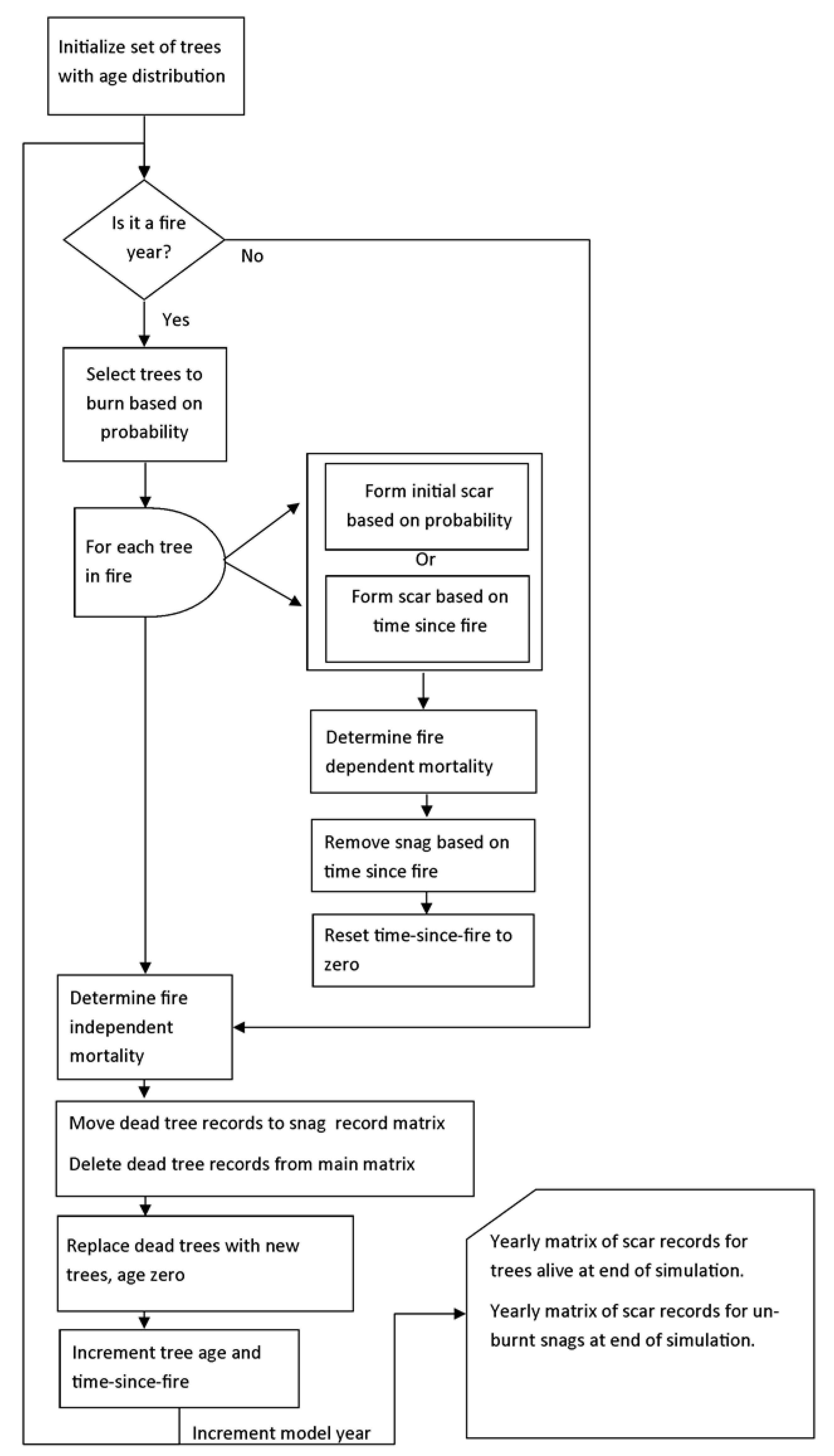
The fire-scar simulation was developed as a non-spatial cell-based model where the growth, mortality and fire scar formation of a fixed number of trees is modelled on a yearly time-step (Figure A1). The model is initiated with a population of trees, one tree per cell, with an age structure defined by a gamma distribution (shape = 6, scale = 0.021), resulting in a peak in tree age distribution at approximately 280 years. For each yearly iteration, the model first determines if it is a year in which a fire is to occur, based on a defined probability Fp. If the current year is a fire year, a random set of cells are selected to be burnt based on probability Bp. For each tree inhabiting a cell that is selected to be burnt, a scar is recorded for that year with a fixed initial scar probability of 0.08 if the tree is thus far unscarred, or with a probability dependent on the time since the last fire in that cell, derived from the function BurnScarTSF if the tree already has a scar, such that there is a higher probability of scar formation with more intense fires following a long fire-free interval. Next, fire-dependent mortality for the trees that were burnt is calculated based tree age using function MortalityF. Consumption of existing snags with scar records in burnt cells is modelled based on time since fire with the BurnScarTSF function, so that existing snags with scar records can be removed with a higher probability if there has been a long time since the previous fire. Finally, the values of burnt cells in the matrix recording time since fire are set to zero.
Figure A1.
Fire scar simulation flow diagram.

After the calculation of fire-dependent scar formation and mortality, fire independent mortality is calculated based on age using the MortalityI function. If a tree has been killed, either as a result of fire or independent of fire, its record of scars is deleted from the main matrix and moved to the snag matrix, and simple recruitment is modelled by initializing a new tree of age zero in the cell. At the end of each year iteration, the age of each tree, and the time since fire of each cell is incremented by one. The model output comprises of a matrix of extant fire scar records for each cell from trees alive at the end of the simulation, and unburnt snags with scar records, which can be processed to derive summary fire regime indices. The simulation also returns a matrix of actual fire occurrence in each cell for each year, representing the reality of fire occurrence for comparison to the scar record.
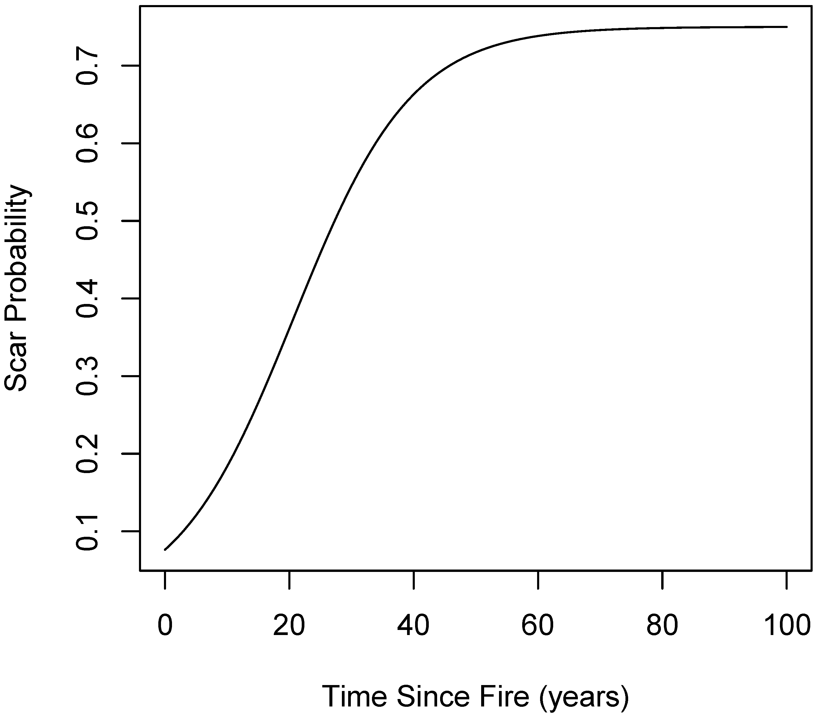
The three functions that determine scar formation (BurnScarTSF), fire-dependent mortality (MortalityF) and fire-independent mortality (MortalityI) define the core parameters of the model, driving the formation and loss of the fire scar record. BurnScarTSF is a logistic function of time since fire (location = 20.7, scale = 9.5) that has been normalized to a maximum probability of 0.75, and was derived by fitting a logistic curve (Figure A2) to scarring probability at a range of times since fire, obtained from the literature for North American conifer forests [33]. MortalityF is a step function that defines the probability of tree death in a fire within four age-classes, parameterized in table 1 from values obtained from the literature [66,67]. Mortality is high for young seedlings, and declines to a low value for trees aged 30–400 years, and then increases for older trees.
Figure A2.
Plot of logistic function for the probability that an already scarred tree will record subsequent scars based on time since last fire.
Figure A2.
Plot of logistic function for the probability that an already scarred tree will record subsequent scars based on time since last fire.
The fire-independent mortality function, MortalityI is a step function that defines the probability of natural tree death within three age-classes, parameterized in Table A2 from values obtained from the literature [68]. Young seedlings and older trees have a high probability of mortality each year, while trees aged 20–400 years have a much lower probability of mortality.

Table A1.
Parameters for fire-dependent mortality function MortalityF.
| Age Class (years) | Fire-Dependent Mortality |
|---|---|
| <10 | 0.7 |
| 10–30 | 0.3 |
| 30–400 | 0.05 |
| >400 | 0.4 |
Table A2.
Parameters for fire-independent mortality function MortalityI.
| Age Class (years) | Fire-Independent Mortality |
|---|---|
| <20 | 0.02 |
| 20–400 | 0.005 |
| >400 | 0.02 |
While the parameters for the initial scar probability and the BurnScarTSF function are well established in the literature, the age-dependent mortality functions are less well defined. A sensitivity analysis was conducted by running 100 simulations with the mortality probabilities within the age classes for MortalityF and MortalityI varied with a uniform distribution within 25% of the base values in a Latin hypercube design. R source code for the simulation runs, summary statistic derivation and plot production are available in a repository online at https://zenodo.org/record/3233290.
A1.1. Simulation Runs
The simulation parameters used to perform all model runs are detailed in Table A3. The first simulation experiment aimed to test the detectability of different fire interval and percentage burnt combinations, with an average burn probability of 100% per year 20 years. Four simulations runs were performed with 100-run in each, for a period of 700 years (including 100-year unanalyzed period to stabilize tree demographics), with a population size of 40,000 trees. The fire intervals for the four simulations included 5% burnt in 100% of years, 25% burnt in 20% of years, 50% burnt in 10% of years, and 100% burnt in 5% of years.
The second simulation experiment aimed to test the detectability of a change in fire regimes at different times before the present. 400 simulation runs were performed for the “wide” fire regime with 5% area burnt in 100% of years before the shift, and 100% burnt in 5% of years after the shift, but with the shift year varying in ten steps from 150 years to 600 years, and 40 replicates performed per shift year. 400 simulation runs with the same set of regime shift years were also performed for the “narrow” fire regime with 25% of the area burnt in 20% of years prior to the shift, then 50% of the area burnt in 10% of years after the shift.
Table A3.
List of simulation experiments performed.
| Experiment | Annual Fire Probability Fp | Burnt Area Bp | Number of Runs | Mortality | Number of Trees | Shift Year |
|---|---|---|---|---|---|---|
| 1. Discrete Fire Regimes | 100% | 5% | 100 | On | 40,000 | None |
| 25% | 20% | 100 | On | 40,000 | None | |
| 10% | 50% | 100 | On | 40,000 | None | |
| 5% | 100% | 100 | On | 40,000 | None | |
| 2. Fire Regime Shifts | 100%/5% | 5%/100% | 40 | On | 40,000 | 150 |
| 100%/5% | 5%/100% | 40 | On | 40,000 | 200 | |
| 100%/5% | 5%/100% | 40 | On | 40,000 | 250 | |
| 100%/5% | 5%/100% | 40 | On | 40,000 | 300 | |
| 100%/5% | 5%/100% | 40 | On | 40,000 | 350 | |
| 100%/5% | 5%/100% | 40 | On | 40,000 | 400 | |
| 100%/5% | 5%/100% | 40 | On | 40,000 | 450 | |
| 100%/5% | 5%/100% | 40 | On | 40,000 | 500 | |
| 100%/5% | 5%/100% | 40 | On | 40,000 | 550 | |
| 100%/5% | 5%/100% | 40 | On | 40,000 | 600 | |
| 25%/10% | 20%/50% | 40 | On | 40,000 | 150 | |
| 25%/10% | 20%/50% | 40 | On | 40,000 | 200 | |
| 25%/10% | 20%/50% | 40 | On | 40,000 | 250 | |
| 25%/10% | 20%/50% | 40 | On | 40,000 | 300 | |
| 25%/10% | 20%/50% | 40 | On | 40,000 | 350 | |
| 25%/10% | 20%/50% | 40 | On | 40,000 | 400 | |
| 25%/10% | 20%/50% | 40 | On | 40,000 | 450 | |
| 25%/10% | 20%/50% | 40 | On | 40,000 | 500 | |
| 25%/10% | 20%/50% | 40 | On | 40,000 | 550 | |
| 25%/10% | 20%/50% | 40 | On | 40,000 | 600 |
References
- Pyne, S.J. Fire in America. A Cultural History of Wildland and Rural Fire; Princeton University Press: Princeton, NJ, USA, 1982. [Google Scholar]
- Dobyns, H.F. From Fire to Flood; Ballena Press: Socorro, NM, USA, 1981. [Google Scholar]
- Vale, T.R. (Ed.) Fire, Native Peoples, and the Natural Landscape; Island Press: Washington, DC, USA, 2002. [Google Scholar]
- Marlon, J.R.; Bartlein, P.J.; Carcaillet, C.; Gavin, D.G.; Harrison, S.P.; Higuera, P.E.; Joos, F.; Power, M.J.; Prentice, I.C. Climate and human influences on global biomass burning over the past two millennia. Nat. Geosci. 2008, 1, 697–702. [Google Scholar] [CrossRef]
- Mooney, S.; Harrison, S.; Bartlein, P.; Daniau, A.L.; Stevenson, J.; Brownlie, K.; Buckman, S.; Cupper, M.; Luly, J.; Black, M. Late Quaternary fire regimes of Australasia. Quat. Sci. Rev. 2011, 30, 28–46. [Google Scholar] [CrossRef]
- Marlon, J.R.; Bartlein, P.J.; Gavin, D.G.; Long, C.J.; Anderson, R.S.; Briles, C.E.; Brown, K.J.; Colombaroli, D.; Hallett, D.J.; Power, M.J. Long-term perspective on wildfires in the western USA. Proc. Natl. Acad. Sci. USA 2012, 109, E535–E543. [Google Scholar] [CrossRef] [PubMed] [Green Version]
- Allen, C.D. Lots of lightning and plenty of people: An ecological history of fire in the upland Southwest. In Fire, Native Peoples, and the Natural Landscape; Vale, T.R., Ed.; Island Press: Washington, DC, USA, 2002; pp. 143–193. [Google Scholar]
- Bird, R.B.; Bird, D.W.; Codding, B.F.; Parker, C.H.; Jones, J.H. The “fire stick farming” hypothesis: Australian Aboriginal foraging strategies, biodiversity, and anthropogenic fire mosaics. Proc. Natl. Acad. Sci. USA 2008, 105, 14796–14801. [Google Scholar] [CrossRef] [PubMed]
- Bowman, D.M.J.S. The Impact of Aboriginal Landscape Burning on the Australian biota. New Phytol. 1998, 140, 385–410. [Google Scholar] [CrossRef]
- Bowman, D.M.J.S.; Prior, L.D. Impact of Aboriginal landscape burning on woody vegetation in Eucalyptus tetrodonta savanna in Arnhem Land, northern Australia. J. Biogeogr. 2004, 31, 807–817. [Google Scholar] [CrossRef]
- Trauernicht, C.; Brook, B.W.; Murphy, B.P.; Williamson, G.J.; Bowman, D.M.J.S. Local and global pyrogeographic evidence that indigenous fire management creates pyrodiversity. Ecol. Evol. 2015, 5, 1908–1918. [Google Scholar] [CrossRef] [Green Version]
- Bird, R.B.; Codding, B.F.; Kauhanen, P.G.; Bird, D.W. Aboriginal hunting buffers climate-driven fire-size variability in Australia’s spinifex grasslands. Proc. Natl. Acad. Sci. USA 2012, 109, 10287–10292. [Google Scholar] [CrossRef]
- Bliege Bird, R.; Bird, D.W.; Codding, B.F. People, El Niño southern oscillation and fire in Australia: Fire regimes and climate controls in hummock grasslands. Philos. Trans. R. Soc. B Biol. Sci. 2016, 371, 20150343. [Google Scholar] [CrossRef]
- Roos, C.I.; Zedeño, M.N.; Hollenback, K.L.; Erlick, M.M.H. Indigenous impacts on North American Great Plains fire regimes of the past millennium. Proc. Natl. Acad. Sci. USA 2018, 115, 8143–8148. [Google Scholar] [CrossRef] [Green Version]
- Swetnam, T.W.; Farella, J.; Roos, C.I.; Liebmann, M.J.; Falk, D.A.; Allen, C.D. Multiscale perspectives of fire, climate and humans in western North America and the Jemez Mountains, USA. Philos. Trans. R. Soc. B Biol. Sci. 2016, 371, 20150168. [Google Scholar] [CrossRef] [PubMed]
- Holz, A.; Veblen, T.T. The amplifying effects of humans on fire regimes in temperate rainforests in western Patagonia. Palaeogeogr. Palaeoclimatol. Palaeoecol. 2011, 311, 82–92. [Google Scholar] [CrossRef]
- Bliege Bird, R.; Tayor, N.; Codding, B.F.; Bird, D.W. Niche construction and Dreaming logic: Aboriginal patch mosaic burning and varanid lizards (Varanus gouldii) in Australia. Proc. R. Soc. Lond. B Biol. Sci. 2013, 280, 20132297. [Google Scholar] [CrossRef] [PubMed]
- Laris, P. Burning the Seasonal Mosaic: Preventative Burning Strategies in the Wooded Savanna of Southern Mali. Hum. Ecol. Interdiscip. J. 2002, 30, 155. [Google Scholar] [CrossRef]
- Sullivan, A.P.; Mink, P.B. Theoretical and Socioecological Consequences of Fire Foodways. Am. Antiq. 2018, 83, 619–638. [Google Scholar] [CrossRef]
- Sullivan, A.P., III. Mogollon Agrarian Ecology. Kiva 1982, 48, 1–15. [Google Scholar] [CrossRef]
- Coughlan, M.R. Errakina: Pastoral Fire Use and Landscape Memory In the Basque Region of the French Western Pyrenees. J. Ethnobiol. 2013, 33, 86–104. [Google Scholar] [CrossRef]
- Allred, B.W.; Fuhlendorf, S.D.; Engle, D.M.; Elmore, R.D. Ungulate preference for burned patches reveals strength of fire–grazing interaction. Ecol. Evol. 2011, 1, 132–144. [Google Scholar] [CrossRef]
- Fuhlendorf, S.D.; Engle, D.M.; Kerby, J.A.Y.; Hamilton, R. Pyric Herbivory: Rewilding Landscapes through the Recoupling of Fire and Grazing. Conserv. Biol. 2009, 23, 588–598. [Google Scholar] [CrossRef]
- Huffman, M.R. The Many Elements of Traditional Fire Knowledge: Synthesis, Classification, and Aids to Cross-cultural Problem Solving in Fire-dependent Systems Around the World. Ecol. Soc. 2013, 18, 3. [Google Scholar] [CrossRef]
- Scherjon, F.; Bakels, C.; MacDonald, K.; Roebroeks, W. Burning the Land: An Ethnographic Study of Off-Site Fire Use by Current and Historically Documented Foragers and Implications for the Interpretation of Past Fire Practices in the Landscape. Curr. Anthropol. 2015, 56, 299–326. [Google Scholar] [CrossRef]
- Dieterich, J.H.; Swetnam, T.W. Dendrochronology of a fire scarred ponderosa pine. For. Sci. 1984, 30, 238–247. [Google Scholar]
- Swetnam, T.W.; Brown, P.M. Climatic Inferences from Dendroecological Reconstructions. In Dendroclimatology; Hughes, M.K., Swetnam, T.W., Diaz, H.F., Eds.; Springer: New York, NY, USA, 2011; Volume 11, pp. 263–295. [Google Scholar]
- Bigio, E.; Swetnam, T.W.; Baisan, C.H. A comparison and integration of tree-ring and alluvial records of fire history at the Missionary Ridge Fire, Durango, Colorado, USA. Holocene 2010, 20, 1047–1061. [Google Scholar] [CrossRef] [Green Version]
- Whitlock, C.; Millspaugh, S.H. Testing the Assumptions of Fire-History Studies: An Examination of Modern Charcoal Accumulation in Yellowstone National Park, USA. Holocene 1996, 6, 7–15. [Google Scholar] [CrossRef]
- Whitlock, C.; Skinner, C.N.; Bartlein, P.J.; Minckley, T.; Mohr, J.A. Comparison of charcoal and tree-ring records of recent fires in the eastern Klamath Mountains, California, USA. Can. J. For. Res. 2004, 34, 2110–2121. [Google Scholar] [CrossRef]
- Pitkänen, A.; Lehtonen, H.; Huttunen, P. Comparison of Sedimentary Microscopic Charcoal Particle Records in a Small Lake with Dendrochronological Data: Evidence for the Local Origin of Microscopic Charcoal Produced by Forest Fires of Low Intensity in Eastern Finland. Holocene 1999, 9, 559–567. [Google Scholar] [CrossRef]
- Falk, D.A.; Heyerdahl, E.K.; Brown, P.M.; Farris, C.; Fulé, P.Z.; McKenzie, D.; Swetnam, T.W.; Taylor, A.H.; van Horne, M.L. Multi-scale controls of historical forest-fire regimes: New insights from fire-scar networks. Front. Ecol. Environ. 2011, 9, 446–454. [Google Scholar] [CrossRef]
- Stephens, S.L.; Fry, D.L.; Collins, B.M.; Skinner, C.N.; Franco-Vizcaíno, E.; Freed, T.J. Fire-scar formation in Jeffrey pine–mixed conifer forests in the Sierra San Pedro Mártir, Mexico. Can. J. For. Res. 2010, 40, 1497–1505. [Google Scholar] [CrossRef]
- Baker, W.L.; Ehle, D. Uncertainty in Surface-Fire History: The Case of Ponderosa Pine Forests in the Western United States. Can. J. For. Res. 2001, 31, 1205–1226. [Google Scholar] [CrossRef]
- Van Horne, M.L.; Fulé, P.Z. Comparing methods of reconstructing fire history using fire scars in a southwestern United States ponderosa pine forest. Can. J. For. Res. 2006, 36, 855–867. [Google Scholar] [CrossRef]
- Farris, C.A.; Baisan, C.H.; Falk, D.A.; Yool, S.R.; Swetnam, T.W. Spatial and temporal corroboration of a fire-scar-based fire history in a frequently burned ponderosa pine forest. Ecol. Appl. 2010, 20, 1598–1614. [Google Scholar] [CrossRef] [PubMed]
- Farris, C.A.; Baisan, C.H.; Falk, D.A.; van Horne, M.L.; Fulé, P.Z.; Swetnam, T.W. A comparison of targeted and systematic fire-scar sampling for estimating historical fire frequency in south-western ponderosa pine forests. Int. J. Wildland Fire 2013, 22, 1021. [Google Scholar] [CrossRef]
- Swetnam, T.W. Fire History and Climate Change in Giant Sequoia Groves. Science 1993, 262, 885–889. [Google Scholar] [CrossRef] [PubMed]
- Kitzberger, T.; Swetnam, T.W.; Veblen, T.T. Inter-Hemispheric Synchrony of Forest Fires and El Niño-Southern Oscillation. Glob. Ecol. Biogeogr. 2001, 10, 315–326. [Google Scholar] [CrossRef]
- Veblen, T.T.; Kitzberger, T. Inter-Hemispheric Comparison of Fire History: The Colorado Front Range, U.S.A., and the Northern Patagonian Andes, Argentina. Plant Ecol. 2002, 163, 187–207. [Google Scholar] [CrossRef]
- Swetnam, T.W.; Baisan, C.H. Tree-ring reconstructions of fire and climate history of the Sierra Nevada and Southwestern United States. In Fire and Climate Change in Temperate Ecosystems of the Western Americas; Veblen, T.T., Baker, C.M., Montenegro, G., Swetnam, T.W., Eds.; Springer: New York, NY, USA, 2003; pp. 158–195. [Google Scholar]
- Swetnam, T.W.; Baisan, C.H.; Caprio, A.C.; Brown, P.M.; Touchan, R.; Anderson, R.S.; Hallett, D.J. Multi-millenial fire history of the Giant Forest, Sequoia National Park, California, USA. Fire Ecol. 2009, 5, 120–150. [Google Scholar] [CrossRef]
- Veblen, T.T.; Kitzberger, T.; Villalba, R.; Donnegan, J. Fire History in Northern Patagonia: The Roles of Humans and Climatic Variation. Ecol. Monogr. 1999, 69, 47–67. [Google Scholar] [CrossRef]
- Drury, S.A.; Veblen, T.T. Spatial and temporal variability in fire occurrence within the Las Bayas Forestry Reserve, Durango, Mexico. Plant Ecol. 2008, 197, 299–316. [Google Scholar] [CrossRef]
- Guyette, R.P.; Muzika, R.M.; Dey, D.C. Dynamics of an Anthropogenic Fire Regime. Ecosystems 2002, 5, 472–486. [Google Scholar]
- McMurry, E.R.; Stambaugh, M.C.; Guyette, R.P. Fire scars reveal source of New England’s 1780 Dark Day. Int. J. Wildland Fire 2007, 16, 266–270. [Google Scholar] [CrossRef]
- Stambaugh, M.C.; Guyette, R.P.; Marschall, J.M. Longleaf pine (Pinus palustris Mill.) fire scars reveal new details of a frequent fire regime. J. Veg. Sci. 2011, 22, 1094–1104. [Google Scholar] [CrossRef]
- Stambaugh, M.; Guyette, R.; Marschall, J. Fire History in the Cherokee Nation of Oklahoma. Hum. Ecol. 2013. [Google Scholar] [CrossRef]
- Lewis, H.T. Hunter-Gatherers and Problems for Fire History. In Proceedings of the Fire History Workshop, Tucson, Arizona, 20–24 October 1980; Stokes, M.A., Dieterich, J.H., Eds.; U.S. Department of Agriculture, Forest Service, Rocky Mountain Research Station: Fort Collins, CO, USA, 1980; pp. 115–119. [Google Scholar]
- Bürgi, M.; Gimmi, U.; Stuber, M. Assessing traditional knowledge on forest uses to understand forest ecosystem dynamics. For. Ecol. Manag. 2013, 289, 115–122. [Google Scholar] [CrossRef]
- Yibarbuk, D.; Whitehead, P.J.; Russell-Smith, J.; Jackson, D.; Godjuwa, C.; Fisher, A.; Cooke, P.; Choquenor, D.; Bowman, D.M.J.S. Fire ecology and Aboriginal land management in central Arnhem Land, northern Australia: A tradition of ecosystem management. J. Biogeogr. 2000, 28, 325–343. [Google Scholar] [CrossRef]
- Fitzgerald, S.A. Fire Ecology of Ponderosa Pine and the Rebuilding of Fire-Resilient Ponderosa Pine Ecosystems. In Proceedings of the Symposium on Ponderosa Pine: Issues, Trends, and Management, Klamath Falls, OR, USA, 18–21 October 2004; Ritchie, M.W., Maguire, D.A., Youngblood, A., Eds.; Pacific Southwest Research Station, Forest Service, U.S. Department of Agriculture: Albany, CA, USA, 2005; pp. 197–225. [Google Scholar]
- Rodonov, S.N. A-sequential algorithm for testing climate regime shifts. Geophys. Res. Lett. 2004, 31, L09204. [Google Scholar] [CrossRef]
- Rodonov, S.N. Detecting regime shifts in the mean and variance: Methods and specific examples. In Large-Scale Disturbances (Regime Shifts) and Recovery in Aquatic Ecosystems: Challenges for Management Toward Sustainability; Velikova, V., Chipev, N., Eds.; UNESCO-ROSTE/BAS Workshop on Regime Shifts: Varna, Bulgaria, 2005; pp. 17–24. [Google Scholar]
- Taylor, A.H.; Trouet, V.; Skinner, C.N.; Stephens, S. Socioecological transitions trigger fire regime shifts and modulate fire–climate interactions in the Sierra Nevada, USA, 1600–2015 CE. Proc. Natl. Acad. Sci. USA 2016, 113, 13684–13689. [Google Scholar] [CrossRef] [PubMed]
- Coughlan, M.; Magi, B.; Derr, K. A Global Analysis of Hunter-Gatherers, Broadcast Fire Use, and Lightning-Fire-Prone Landscapes. Fire 2018, 1, 41. [Google Scholar] [CrossRef]
- Bowman, D.M.J.S.; Perry, G.L.W.; Higgins, S.I.; Johnson, C.N.; Fuhlendorf, S.D.; Murphy, B.P. Pyrodiversity is the coupling of biodiversity and fire regimes in food webs. Philos. Trans. R. Soc. B Biol. Sci. 2016, 371, 20150169. [Google Scholar] [CrossRef] [Green Version]
- Krawchuk, M.A.; Haire, S.L.; Coop, J.; Parisien, M.-A.; Whitman, E.; Chong, G.; Miller, C. Topographic and fire weather controls of fire refugia in forested ecosystems of northwestern North America. Ecosphere 2016, 7, e01632. [Google Scholar] [CrossRef]
- Bradstock, R.A.; Bedward, M.; Gill, A.M.; Cohn, J.S. Which mosaic? A landscape ecological approach for evaluating interactions between fire regimes, habitat and animals. Wildl. Res. 2005, 32, 409–423. [Google Scholar] [CrossRef] [Green Version]
- Iniguez, J.M.; Swetnam, T.W.; Baisan, C.H.; Sieg, C.H.; Fulé, P.Z.; Hunter, M.; Allen, C.D.; Brooks, M.L.; Balice, R.G. Spatially and temporally variable fire regime on Rincon Peak, Arizona, USA. Fire Ecol. 2009, 5, 3–21. [Google Scholar] [CrossRef]
- Farris, C.A.; Baisan, C.H.; Yool, S.R.; Swetnam, T.W. Spatial and temporal corroboration of fire-scar based fire history reconstructions in a frequently burned wilderness area in southern Arizona. Can. J. For. Res. 2010, 20, 1598–1614. [Google Scholar]
- Roos, C.I.; Bowman, D.M.J.S.; Balch, J.K.; Artaxo, P.; Bond, W.J.; Cochrane, M.; D’Antonio, C.M.; DeFries, R.; Mack, M.; Johnston, F.H.; et al. Pyrogeography, historical ecology, and the human dimensions of fire regimes. J. Biogeogr. 2014, 41, 833–836. [Google Scholar] [CrossRef]
- Bowman, D.M.J.S.; Balch, J.K.; Artaxo, P.; Bond, W.J.; Cochrane, M.A.; D’Antonio, C.M.; DeFries, R.S.; Johnston, F.H.; Keeley, J.E.; Krawchuk, M.A.; et al. The human dimension of fire regimes on Earth. J. Biogeogr. 2011, 38, 2223–2236. [Google Scholar] [CrossRef] [PubMed] [Green Version]
- Bowman, D.M.J.S.; O’Brien, J.A.; Goldammer, J.G. Pyrogeography and the Global Quest for Sustainable Fire Management. Annu. Rev. Environ. Resour. 2013, 38, 57–80. [Google Scholar] [CrossRef]
- Roos, C.I.; Scott, A.C.; Belcher, C.M.; Chaloner, W.G.; Aylen, J.; Bird, R.B.; Coughlan, M.R.; Johnson, B.R.; Johnston, F.H.; McMorrow, J.; et al. Living on a flammable planet: Interdisciplinary, cross-scalar and varied cultural lessons, prospects and challenges. Philos. Trans. R. Soc. B Biol. Sci. 2016, 371, 20150469. [Google Scholar] [CrossRef] [PubMed]
- Battaglia, M.; Smith, F.W.; Shepperd, W.D. Predicting mortality of ponderosa pine regeneration after prescribed fire in the Black Hills, South Dakota, USA. Int. J. Wildland Fire 2009, 18, 176–190. [Google Scholar] [CrossRef]
- Swezy, D.M.; Agee, J.K. Prescribed-fire effects on fine-root and tree mortality in old-growth ponderosa pine. Can. J. For. Res. 1991, 21, 626–634. [Google Scholar] [CrossRef]
- Arno, S.F.; Scott, J.H.; Hartwell, M.G. Age-Class Structure of Old Growth Ponderosa Pine/Douglas—Fir Stands and Its Relationship to Fire History; U.S. Department of Agriculture, Forest Service, Intermountain Research Station: Ogden, UT, USA, 1995; Volume INT-RP-481.
Figure 1.
Box and whisker plots of tree-ring reconstructed mean fire interval (MFI) measurements (y-axes) by fire regime (columns), filter level (rows), and by sample size (x-axes) for targeted sampling strategies. The shaded region is the range of actual fire-intervals experienced across all 100 simulations for that fire regime. Note that MFIall accurately describes all fire regime at 50 or fewer samples. Note also that when filtering the fire-scar record at 10% or 25% level, targeted sampling regimes never accurately describe any of the fire regimes.

Figure 2.
Box and whisker plots of tree-ring reconstructed MFI measurements (y-axes) by fire regime (columns), filter level (rows), and by sample size (x-axes) for probabilistic sampling strategies. The shaded region is the range of actual fire-intervals experienced across all 100 simulations for that fire regime. Note that it takes larger sample sizes to accurately describe the fire regime using a probabilistic sampling strategy than a targeted one (Figure 1). Note also that when filtering the fire-scar record at 10% or 25% level, probabilistic sampling regimes never accurately describe any of the fire regimes.
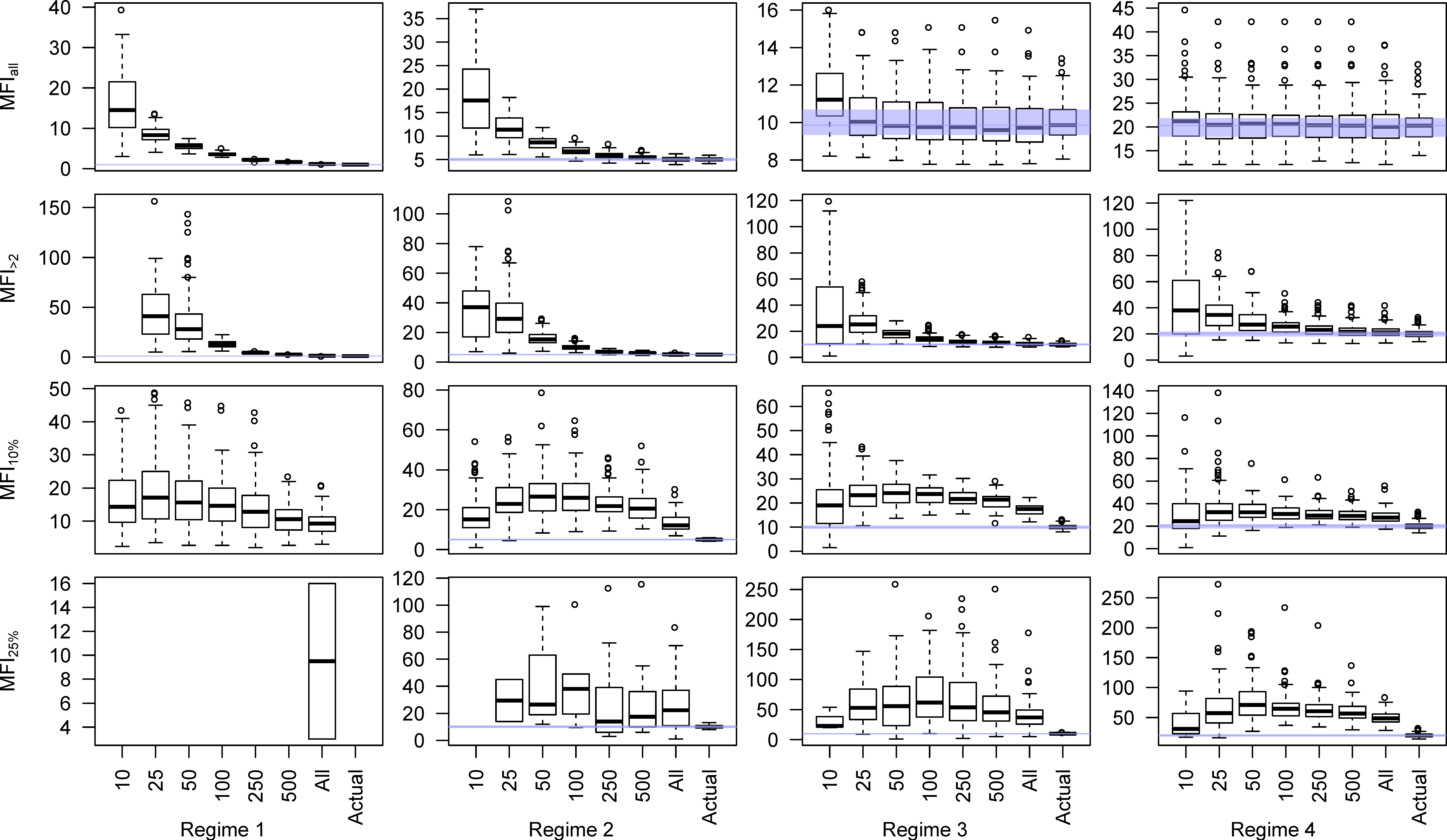
Figure 3.
Boxplots of MFI (y-axes) at different sample sizes (x-axes) for different levels of filtering for all four fire regimes over 100 simulations each. Note that the four fire regimes are clearly differentiated at 25 samples (0.0625 samples ha−1) in the unfiltered (MFIall) dataset but are difficult to distinguish reliably in the highly filtered MFI25%.
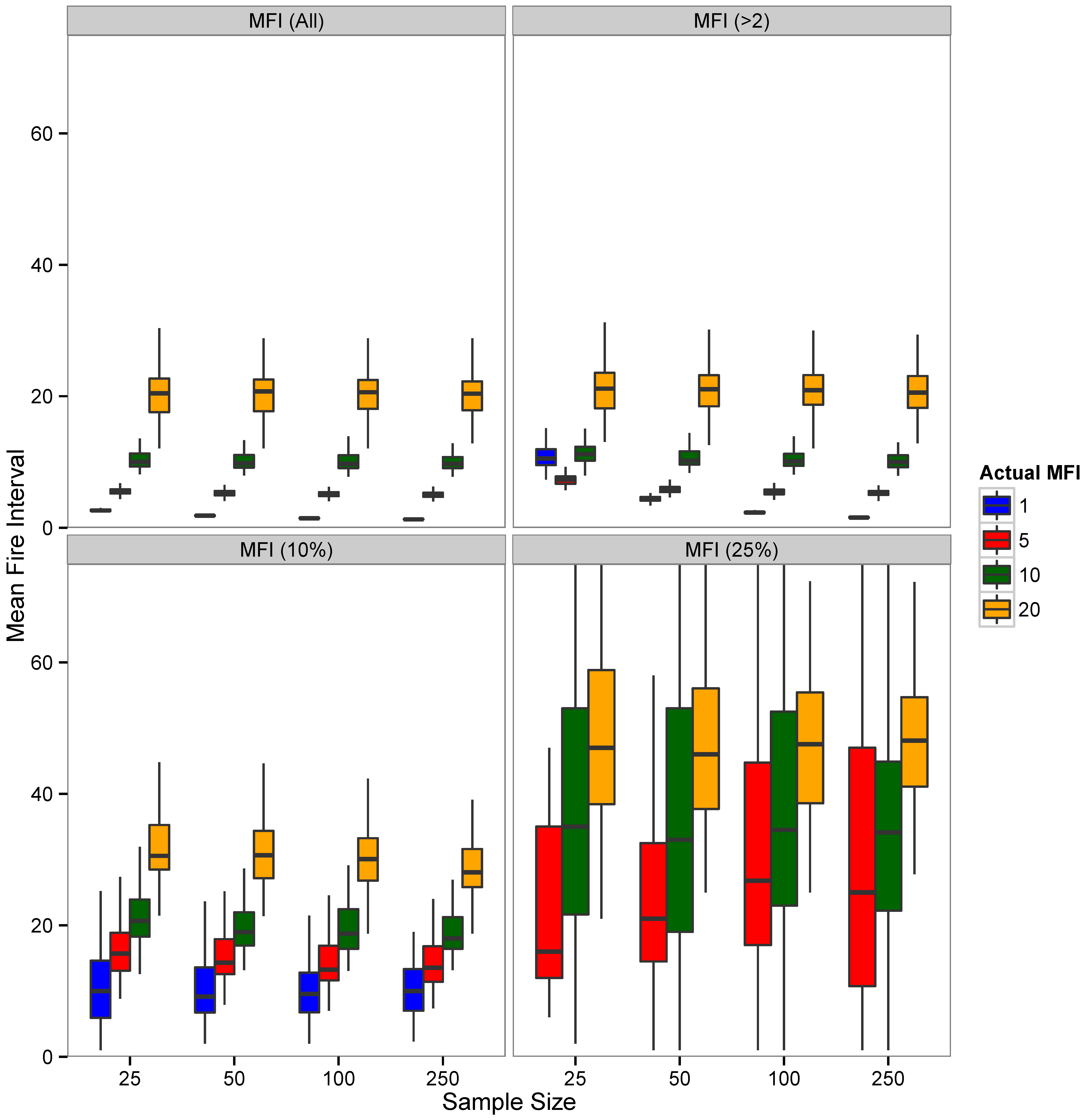
Figure 4.
Histograms of inferred regime shifts from moving t-tests relative to the known regime shift date in Scenario 1 (shift from annual patch burning to bidecadal spreading fires). Columns are for the date before the end of the model run when the forced regime shift happened. Corresponding centuries in the real world are shown for comparison to fire-scar studies. Rows are for different sampling intensities. Red histograms denote scenarios where the majority of the regime shift simulations (>20 model runs) were accurately identified. Note that recent regime shifts are accurately predicted at all sampling intensities. Greater sampling intensities are needed to identify regime shifts further in the past but even census level sampling does not correctly identify regime shifts that are beyond the typical lifespan of the modeled tree (400 years, see Appendix A).

Figure 5.
Histograms of inferred regime shifts from moving t-tests relative to the known regime shift date in Scenario 2 (shift from semidecadal patch burning to decadal spreading fires). Columns are for the date before the end of the model run when the forced regime shift happened. Corresponding centuries in the real world are shown for comparison to fire-scar studies. Rows are for different sampling intensities. Note that in no scenario does the statistical regime shift detection correctly identify the regime shift for the majority of simulations (>20 model runs; these histograms are indicated in red in FIGURE 4), even at total census level sampling and for recent regime shifts.

Figure 6.
An idealized research process for integrating human information (archaeological, historical, ethnographic) and relevant paleofire information to identify anthropogenic pyrodiversity.
Figure 6.
An idealized research process for integrating human information (archaeological, historical, ethnographic) and relevant paleofire information to identify anthropogenic pyrodiversity.
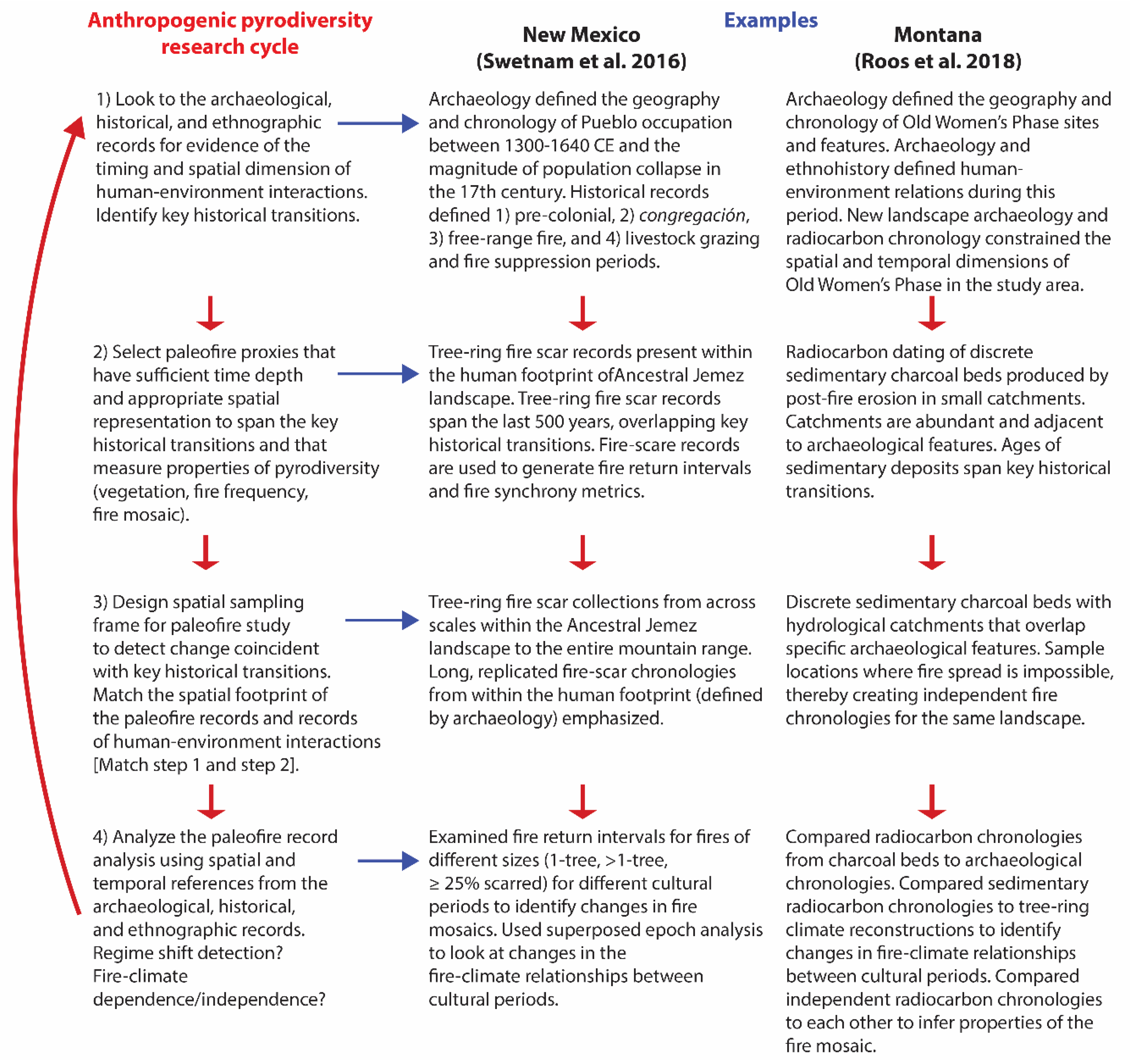
Table 1.
Description of the probability used to determine whether a time-step was a fire year, and the probability that each cell would burn in a fire year for each of the four modeled fire regimes. Note that all four fire regimes have a natural fire rotation of 20 years within which an area equal to 100% of the landscape could burn.
| Fire Regime | Fire Year Probability | Cell Specific Burn Probability during Fire Years |
|---|---|---|
| Annual patch burning | 100% | 5% |
| Semidecadal patch burning | 20% | 25% |
| Decadal spreading fires | 10% | 50% |
| Bidecadal spreading fires | 5% | 100% |
© 2019 by the authors. Licensee MDPI, Basel, Switzerland. This article is an open access article distributed under the terms and conditions of the Creative Commons Attribution (CC BY) license (http://creativecommons.org/licenses/by/4.0/).
Share and Cite
MDPI and ACS Style
Roos, C.I.; Williamson, G.J.; Bowman, D.M.J.S. Is Anthropogenic Pyrodiversity Invisible in Paleofire Records? Fire 2019, 2, 42. https://0-doi-org.brum.beds.ac.uk/10.3390/fire2030042
AMA Style
Roos CI, Williamson GJ, Bowman DMJS. Is Anthropogenic Pyrodiversity Invisible in Paleofire Records? Fire. 2019; 2(3):42. https://0-doi-org.brum.beds.ac.uk/10.3390/fire2030042
Chicago/Turabian StyleRoos, Christopher I., Grant J. Williamson, and David M. J. S. Bowman. 2019. "Is Anthropogenic Pyrodiversity Invisible in Paleofire Records?" Fire 2, no. 3: 42. https://0-doi-org.brum.beds.ac.uk/10.3390/fire2030042