
Fire Risk Assessment of Heritage Villages: A Case Study on Chengkan Village in China

1
State Key Laboratory of Fire Science, University of Science and Technology of China, Hefei 230026, China
2
School of Architecture and Planning, Anhui Jianzhu University, Hefei 230601, China
3
Public Utility Service Center, Shantou Integrated Free Trade Zone, Shantou 515071, China
4
School of Urban and Regional Science, East China Normal University, Shanghai 200062, China
*
Author to whom correspondence should be addressed.
Fire 2023, 6(2), 47; https://0-doi-org.brum.beds.ac.uk/10.3390/fire6020047
Submission received: 11 December 2022
/
Revised: 19 January 2023
/
Accepted: 22 January 2023
/
Published: 25 January 2023
(This article belongs to the Collection Heritage and Fire)
Abstract
:Fire risk assessment is important in heritage-village risk management and cultural relics protection. This study aims to establish a fire risk assessment system and model to assess fire safety for heritage villages. Given the complexity and openness of the heritage village system, the nonlinearity of the driving factors, and the dual attributes of residence and tourism, this paper constructs an index system of three aspects: cultural relic value sensitivity, village fire hazard, and evacuation accessibility. Based on ANP and the Bayes algorithm, a hybrid intelligent model is developed, and the index is weighted by combining subjective expert scoring and objective fact statistics. Finally, ArcGIS buffer and network analysis functions are used for grid processing to quantify and evaluate the difference in fire risk distribution in spatial units of heritage villages. We apply this assessment method to Chengkan Village, a national critical cultural relic protection unit. The results reveal that the cluster settlement layout pattern of the ancestral temple buildings plays a decisive role in the fire risk distribution in Chengkan Village; furthermore, the main factors leading to fire risk were analyzed. In Chengkan Village’s core area, the focus of the local government should be on strengthening active fire prevention measures to reduce the probability of fire. In contrast, in the northern and southern areas, it should focus on enhancing passive fire prevention measures to reduce the possibility of significant fires.
1. Introduction
Fire has a high probability of occurrence and can cause large-scale destruction to heritage villages, making it the main threat to their sustainable development [1]. Heritage villages refer to the cultural heritage of material and non-material forms that offer non-renewable historical, cultural, architectural, and research value [2]. The cultural relic characteristics of heritage villages make it such that once a fire has been produced, it will cause irreparable and huge cultural relic value loss and have a devastating impact on the regional cultural environment and inheritance [3].
China’s heritage villages are critical areas for the early development of regional culture in history. The layout pattern of villages and architecture types are well preserved, with unique regional culture research and cultural relic protection value [4]. The existing heritage villages in China are made up of mainly ancient wooden buildings with decaying wooden components and fire-retardant coatings that are peeling off, which result in poor fire resistance. The overall flammability of the buildings is extreme and easily spreads [5]. With the development of tourism, the vast majority of heritage villages have entered the high development and utilization stage. The types and number of fire risk factors are multiplying, susceptibility to fires is increasing, and the difficulty of firefighting is heightened. The original spatial living attributes of the villages contradict the demand for tourism functions. The fire problem is very prominent due to the influence of history and the changes across time. A large number of Chinese heritage villages are facing the fate of annexation and extinction [6]. From 2010 to 2021, the Chinese government reported 16 fires at the level of heritage settlements. The recent severe fire in Wengding ancient village prompted the authorities to re-examine the fire assessment and prevention measures in heritage villages. The Ministry of Housing and Urban Rural Development and the State Administration of Cultural Heritage established a national protection directory for the protection of heritage settlements [7,8].
Although the fire risk assessment of historic buildings is an established research topic [9,10,11], expanding the scope to include settlements is still a relatively new problem [12]. Given the complexity and openness of the heritage village system, the nonlinearity of driving factors, and the possible mutation of personnel factors, existing models, algorithms, and assessment methods needs to be more rigorous. Different fire protection perspectives and types of research objects affect the measurement and quantification of fire risk. Previous studies mainly focused on quantifying the overall fire risk probability level of heritage villages and assessing the vulnerability of building units to fire through, for example, building unit modeling [13,14], quantitative assessment [14,15], and spatial analysis [16,17]. The assessment index is limited to the basic factors of fire, traffic, and fire protection level, and the relationship between population density and fire risk caused by cultural relics and the tourism attributes of heritage villages has not been considered in the literature. In particular, fire risk level has not been quantified based on the combination of cultural relic value and fire probability.
In this study, we construct multi-scale nested evaluation indicators from three levels of cultural relic value sensitivity, village fire hazard, and evacuation accessibility, and the indicator weighting algorithm integrates expert scoring and a statistical mathematical model. A fire assessment model for heritage villages is proposed, considering the characteristics of cultural heritage and tourism attributes of heritage villages, and integrating the subjective and objective weights. This model is applied to Chengkan Village, a heritage village with “one village and two national treasures” in Anhui Province, China; it helps evaluate and reveal the proportion of different risk factors and the spatial distribution characteristics of village fire risk, and analyze the different major risk factors in different regions of the village. Furthermore, suggestions to improve the limited fire prevention resource allocation of heritage villages and the selection of fire prevention strategies in various regions of these villages are made.
2. Materials
2.1. Site Context and Overview of the Study Area
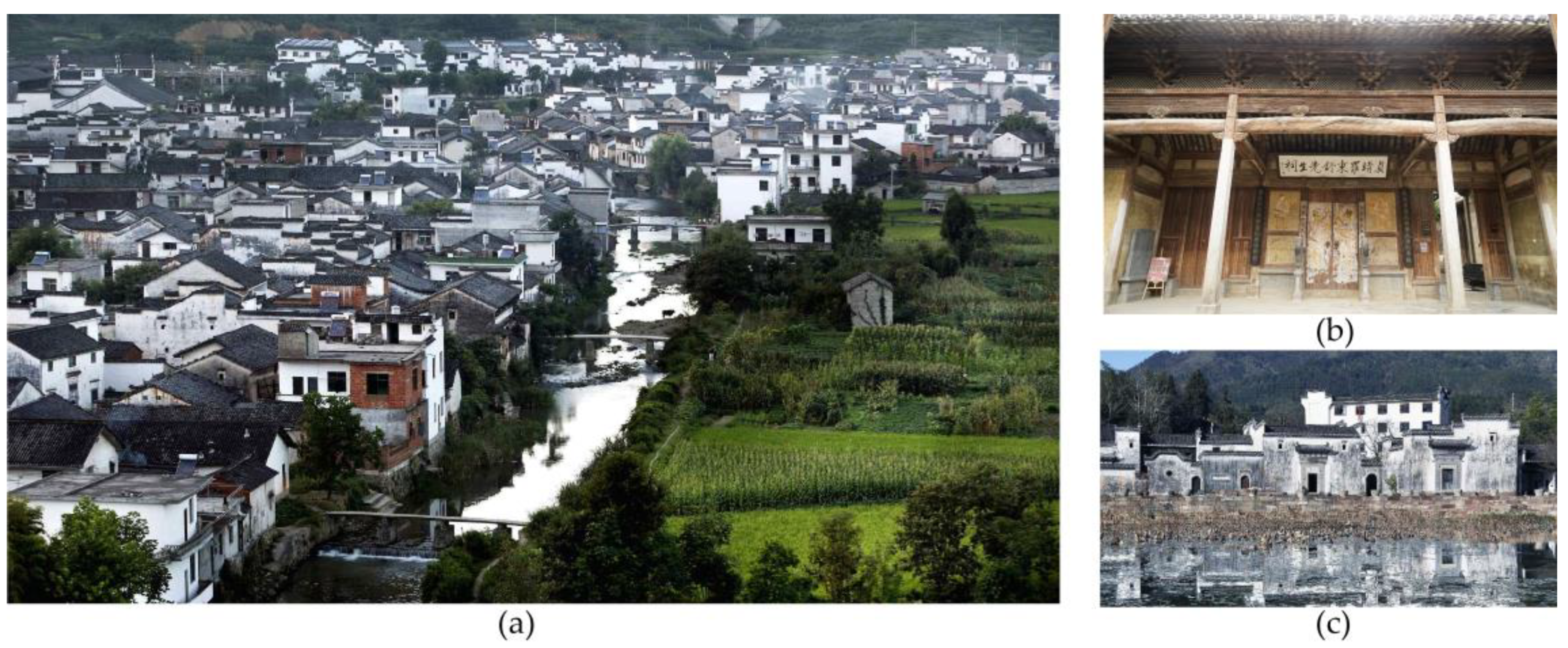
Chengkan Village, which occupies an area of 8.24 square kilometers, is an ancient cultural village with a long history and profound cultural accumulation, and a typical representative of Huizhou culture, one of the three regional cultures in China. It is located in the northern basin of Huizhou District, Huangshan City, Anhui Province, China. The village has more than 700 households and a population of about 3000 people. In 2001, the State Council recognized Chengkan Village as a national critical cultural relic protection unit (Figure 1) as it has a history of nearly 1000 years. It is one of the most well-preserved ancient villages in China and is among almost 50 national cultural relic protection units. There are several cultural relic buildings in the village, and they are highly valued and rich in variety.
Chengkan Village is a typical representative of the existing ancient dwellings of the Ming and Qing dynasties. It has more than 150 cultural relics and buildings spanning the Song, Yuan, Ming, and Qing dynasties, and 22 national key protected cultural relics; it includes the third batch of nationally protected cultural relics, the Luo Dongshu Ancestral Temple, and the fourth batch of nationally protected cultural relics, which are ancient buildings of the Ming Dynasty (Figure 2). The “Twin national treasure village” is rare in China and is known as the village with the most national treasures in the country [18].
Compared with western stone buildings, Chinese wooden buildings are more challenging to preserve. China’s ancient buildings are often in a state of unprotected management due to their large quantity and the lack of attention they are given. Wooden structures are difficult to remodel. Once a fire occurs under the destruction of war and natural disasters, it will cause severe loss of national resources and ancient architectural specimens. The architectures of the Ming Dynasty in China are already scarce. In the early 1990s, there were more than 30 ancient architectures from the Ming Dynasty and more than 300 from the Qing Dynasty in Chengkan Village, which is the largest number of ancient buildings from these dynasties in a heritage village [19]. Presently, however, there are only 100 buildings from the Ming and Qing Dynasties, with less than 20 from the Ming Dynasty. The local government started the third phase of the National Cultural Relics Protection Model Project in 2013, to preserve the critical cultural relics in Chengkan Village. However, so far, this project has covered less than ten percent of the total number of buildings in the village.
As shown in Table 1. Disasters in the heritage villages in Huizhou culture core region from 2000 to 2020, almost every year for more than a decade, a Ming Dynasty building and several Qing Dynasty buildings have been destroyed due to natural disasters and human causes, resulting in their continuous disappearance in Chengkan. The timber structure characteristics of the heritage village, and the dual factors of natural and man-made causes have led to major disaster loss in Chengkan Village. The nearest fire brigade in Huizhou District is 14 km away. In addition to traveling the considerable distance, the fire truck cannot enter the narrow streets of the village. It was not until 2007 that a dedicated fire brigade with limited personnel was established in the village of Chengkan. In 2016, a mini fire truck was equipped to compensate for the lack of external firefighting forces. However, the strength of the firefighting forces is still weak compared to the vast ancient building population.
2.2. Date Sources
The vector data of the building distribution in Chengkan Village were obtained from the survey and map data of the Huangshan Planning and Design Institute. Data on architecture protection levels, building height, building quality, building renovation mode, fire hydrant layout, etc., were acquired from the Protection Planning for the Historical and Cultural Village of Chengkan Village in Huizhou District of Huangshan City, the Protection and Utilization Planning of Chengkan Village in Chengkan Town of Huizhou District, the Beautiful Village Construction Planning of Chengkan Village in Huizhou District, and the traditional village declaration and construction archives of Chengkan Village. The authors’ fieldwork was conducted between 21 September 2019 and 3 March 2021, and focuses on the investigation of the current occupancy and tourism distribution, the measurement of the street width, turning radius, and other data related to modern fire protection, as well as the analysis and statistics of the existing traditional fire protection facilities.
3. Methodological Framework
3.1. Risk Assessment Model Establishment
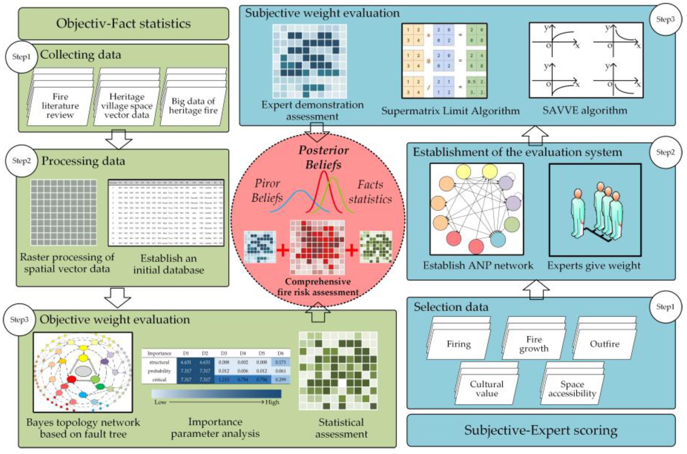
As a combustion phenomenon with a complex nature, fire is the result of the interaction of natural and social factors. It involves a three-dimensional, multiphase, multi-scale, unsteady, and nonlinear dynamic process in which matter and energy interact under complex and changeable environmental conditions. It has dual laws of combustion regularity and randomness of occurrence [20]. This paper considers the complexity and openness of the heritage village system, nonlinearity of fire driving factors, and the dual attributes of traditional residence and heritage tourism. As shown in Figure 3, this paper integrates a variety of intelligent algorithms into a comprehensive fire risk assessment model for heritage villages based on objective fact statistics and subjective expert scoring.
The objective weight values of fire risk factors are calculated based on the Bayes topological network structure model, and the main steps are as follows: (1) Systematically sort out the fire incidents of domestic heritage villages in recent years and select the data on cultural relic value sensitivity, village fire hazard, and evacuation accessibility of the index system. (2) Collect, vectorize, and preprocess the data to create a fire disaster database. (3) Conduct binary processing of the influence of risk factors on fire loss in the database data and input the weight values according to three levels: structural importance, probability importance, and critical importance into the Bayes topology network of Netica software. (4) Determine the most effective and feasible fire strategy through importance comparison and calculate the objective evaluation weight of the different fire factors.
The ANP-SAVEE algorithm calculates the subjective weight value of fire factors through the following main steps: (1) Select, collect, and preprocess the fire risk index of heritage villages, and design a fire risk factor weight scoring questionnaire. (2) Establish an evaluation system based on the network analytic hierarchy process from the perspective of fire risk factors and evaluation objectives, and calculate the average weight of multiple experts. (3) The SAVEE algorithm standardizes the factor values, converts all values into −1 and 1, and obtains the subjective evaluation weights of different fire factors based on the normalization of expert scoring.
Finally, through the vectorization processing of geographic information of the research object and the investigation and collection of fire risk data, the calculated comprehensive evaluation weight is used to discuss the difference in fire risk distribution in the spatial units of heritage villages. This provides new insights into fire prevention and management strategies related to fire risk assessment.
3.2. Construction of Evaluation Index System
The selection of an index system is the basis of fire risk assessment. Considering the long-term potential particularity of fire risk factors, fire hazards may occur in various forms other than flames, such as through an ignition source, fire load, evacuation route defects, and other fire factors [21]. Based on the dual attributes of fire regularity and randomness, this paper combines the government’s protective planning and on-site survey data, selects multi-level determination and an uncertainty index from the macro and micro perspectives, and constructs a fire-risk index system that comprehensively considers cultural relic value sensitivity, village fire hazards, and the evacuation accessibility of heritage villages (Table 2):
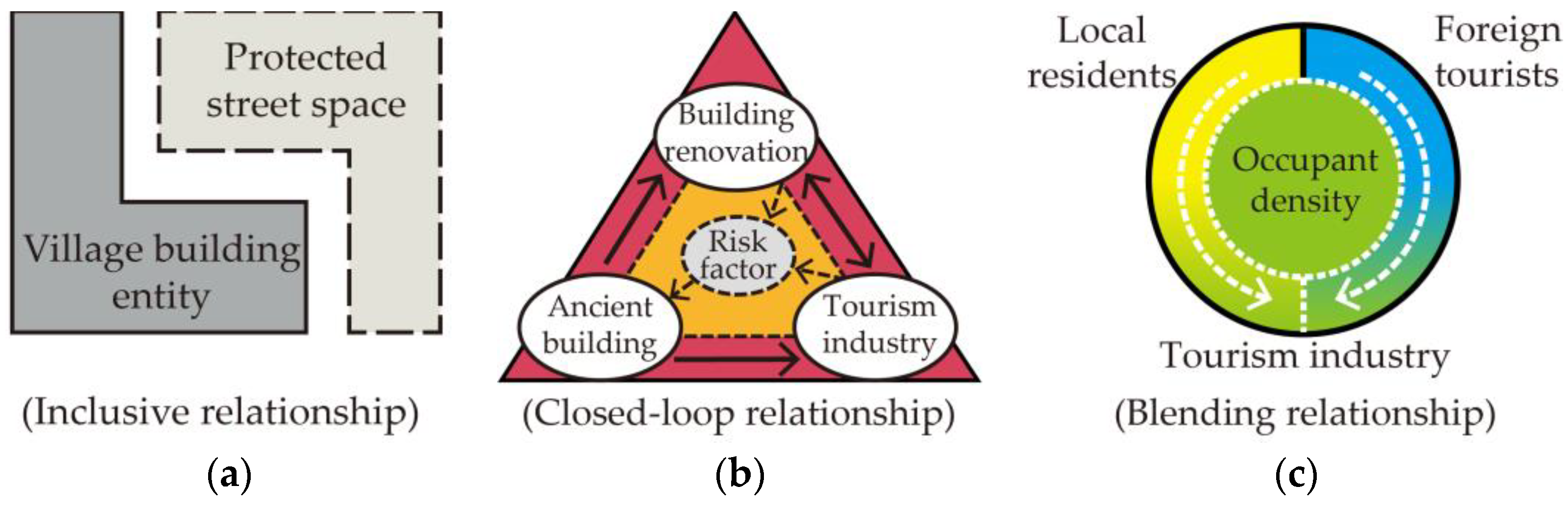
- Cultural relic value sensitivity: This reflects the loss in value of cultural heritage buildings in the event of disasters. According to UNESCO, cultural heritage can be divided into tangible and intangible categories. A village heritage is “the largest combination and sum of material culture and intangible cultural heritage” and a comprehensive cultural heritage [22]. Villages are the spatial field of diachronic development. In the past, more attention was paid to the entity and tangible aspects of a heritage [23] rather than its sensory and intangible aspects. With the introduction of some concepts related to the environment, psychology, and human behavior in science, philosophy, and environmental science, a space’s qualitative and semantic aspects have been developed [24]. According to the Chinese government’s heritage village protection plan, street space, as well as the factors affecting it, present an inclusive relationship, as shown in Figure 4a.
- Village fire hazard: Scholars have extensively researched the fire factors of ancient villages with wooden structures [5,25]. Combined with the three elements of “combustible-oxidant-temperature” in the fire dynamics theory, the risk index of heritage villages is selected. The wooden structures of ancient buildings are natural combustibles and the root cause of fire. The fire load and fire resistance level of ancient buildings are directly related to the severity of fires [26]. However, once the fire load of the wooden structure of ancient buildings has been determined, it will remain almost unchanged for a long period of time. This fixed fire load accounts for a large proportion of the total fire load, far exceeding the fire resistance limit of the structure. At the same time, structural stability and integrity are key factors in the survival of heritage architecture [27,28]. The stated attributes of ancient buildings threaten their very existence.
The material entity of oxidants and temperature are fire risk factors that are the direct cause of fire. Most ancient buildings in heritage villages require different levels of maintenance. Due to the use of various forms of energy and materials during construction, the fire load and moving embers exist simultaneously, which can easily cause fires if there is a lack of supervision [29,30]. Moreover, the tourism industry relies on the rapid development of heritage villages. Increasing moving embers and electric power facilities lead to increased risk sources [31], which makes heritage villages more prone to fire risk. These factors form a closed-loop relationship of fire dynamics as shown in Figure 4b. In fire prevention and control systems, more modern firefighting facilities, such as fire hydrants and micro fire engines, are included as firefighting methods.
- Evacuation accessibility: Consider fire protection and evacuation from the three loss levels of fire risk in buildings: “building-fire-personnel”. In densely populated areas, passageways are regarded as the basis for active fire prevention measures, such as the use of fire engines and firefighting equipment. The planning time of the traffic network of heritage villages is not based on modern methods of transportation, and fire protection and evacuation capacity are directly related to the traffic grade of roads in the villages. Ensuring smoothness and accessibility will help reduce fire hazards [32]. In addition, since the residential and tourism functions of heritage villages coexist, and the population in the village is mainly composed of local residents and foreign tourists, occupant density can be a basis for decision-making in evacuation planning. It should also be the precondition for evaluating evacuation safety [33]. The local residents’ industry is driven by tourism to a certain extent. There is a crossover between the groups, and the factors present a blending relationship in Figure 4c.
3.3. Objective Evaluation of Index Weight Based on Bayes
3.3.1. Algorithm
Bayes theory is one of the fundamental theories of probability. The time of fire occurrence in heritage buildings is uncertain, and the loss is difficult to estimate. The nonrenewable nature of heritage buildings makes it impossible to carry out statistical repeated fire tests. Bayes theory assigns random variables to uncertain parameters. Further, it determines the posterior distribution of probability density and the optimal estimation of parameters according to available and subsequent conditional information, which are suitable for solving the uncertainty problem in the study of heritage village fire risk assessment [34].
Bayesian network (BN) is the basis of Bayes analysis. It is a directed acyclic graph (DAG) composed of nodes and a conditional probability table (CPT) and is the external manifestation of qualitative analysis. It reveals the logical causal relationship between nodes and can perform forward and backward reasoning. The DAG is composed of nodes and directed edges as shown in Figure 5. The nodes represent fire risk state variables, including root and leaf nodes. Directed edges point from root nodes to leaf nodes. CPT represents the dependency relationship between leaf and root nodes and quantitatively describes the impact intensity between nodes [35].
The calculation formula of probability P and weight β”(A1n) of each evaluation index in the Bayes network is as follows:
N is the number of nodes, F and E are random variables, F = f is a set of event assumptions, and E = e is a set of conditions. Before condition E = e occurs, the influence probability P(F) on event F = f is called the prior probability. After condition E = e occurs, the probability of impact P(F|E) on event F = f is called the posterior probability.
3.3.2. Algorithm Steps
The Bayes network established in this study aims to statistically quantify historical fire data to obtain objective weight values of fire factors. The process of analysis is as follows:
- Determine the network structure. According to the three-level index system, the influence factors are divided into the fire dynamic layer for the cultural value, fire development (fire, growth, fire), occupant density, and the 15 fire risk factors concept layer. The topological network diagram of the Bayes fire risk assessment index is then constructed as shown in Figure 6.
- Determine network parameters. The network parameters represent the essential characteristics of the assessment object and the degree of correlation and dependence between the root and leaf nodes, their composition consists of the node variable parameters and the conditional probability table. The node variable parameters determine the prior probability and posterior probability. The conditional probability table is used to quantify the influence of root nodes on leaf nodes and the level of fire risk occurrence. Based on the Bayes topology network structure diagram, the second level index layer is binarized and abstracted, as shown in Table 3. Netica simplifies the Bayesian calculation network. The collected heritage-village fire data from 2009 to 2020 are processed in correspondence to the simplified second level evaluation index layer. After the input sample data is calculated, the network parameters of each root node and leaf node and the mutual information values between various factors are obtained, as shown in Figure 7.
- Determine the objective weight. Based on the Netica-Bayes network diagram constructed, according to Equation (3), the structural importance is obtained when the probability of root node occurrence is set to 50%. The probability importance is obtained by substituting the network parameters in Figure 7. Furthermore, the critical importance is obtained according to Equation (4) (Table 4). The final score of the evaluation index of each node in this layer can be obtained by adding and averaging the derived importance, resulting in the objective weight of the evaluation index.
P(T) is the probability of the top event; qi is the probability of occurrence of the ith basic event. is the critical importance coefficient of the ith basic event; is the probability importance coefficient of the ith basic event.
3.3.3. Objective Weight Analysis
Importance is a method used to define the core factors of the Bayes network. The relationship between fire risk and risk factors in heritage villages is expressed by three importance degrees, which can clarify the importance of each factor on fire risk from different perspectives and provide suggestions for fire prevention measures at different levels [36]. As the fundamental attributes of the protected object, the cultural value attributes (D1, D2) cannot be changed, so the residual importance coefficient gradient is analyzed after exclusion:
- Structural importance: By ignoring the occurrence probability of each root node, the overall Bayes topology network analysis can reflect the impact of this risk factor on the occurrence of leaf node events. The value is proportional to the impact intensity, which is an index reflecting the objective importance weight. As can be seen from Table 4, the fire resistance level (D6) and fire load (D7) of heritage village buildings, the strength of fire force (D8) and the required traffic conditions (D9), and the passengers (D10) and local residents (D11) involved in the evacuation (i.e., the three levels: fire occurrence-firefighting-evacuation) have a significant impact on the fire losses of heritage villages from the perspective of the Bayes topology network structure.
- Probability importance: This refers to the ability to reflect the change of leaf node probability caused by the fluctuation of the probability of a root node. Through the analysis of probability importance, we can identify targeted measures that can effectively reduce the probability of the occurrence of leaf nodes. The greater the probability of importance, indicating that the use of measures to reduce the probability of the occurrence of risk factors can effectively reduce the probability of the occurrence of leaf node events. It can be seen from Table 4 that the most effective measures are to dredge fire rescue channels (D9), guide evacuation (D10), and conduct fire evacuation drills and fire promotion for local residents (D11). At the same time, it is also essential to strengthen the firefighting force and reduce the fire load of buildings.
- Critical importance: This is further obtained through probability importance, indicating that it is easier to reduce the prior probability of the basic probability event than the low basic probability event using measures. The greater the critical importance, the greater the possibility of taking measures to reduce risk factors. It can be seen from Table 4 that the management and monitoring of moving ember (D3) generated by environmental protection and sundries, fixed ember (D4) generated by building decoration and maintenance, and fixed risk sources (D5), such as wires and cables, can most effectively reduce the probability of fire in heritage villages. At the same time, the targeted repair and transformation of the building’s fire resistance rating (D6) and fire load (D7) also produced good results.
3.4. Subjective Evaluation Index Weights Based on ANP
3.4.1. Relevant Algorithms
Analytic Network Process (ANP) is an extension of AHP. It is a process of orderly hierarchical analysis for complex problems with multiple influencing factors. It replaces the hierarchical structure of AHP with a network structure and replaces the linear structure with a nonlinear structure. It also adds a feedback mechanism between decision factors to establish a more complex influence relationship. The ANP solves the issue of the factors in a complex system being too independent and not closely related, which does not conform to the objective reality of their interaction within the system. It is suitable for solving the problem of a dependent and feedback decision structure in the fire risk assessment system. As shown in Figure 8a, the ANP system is composed of two parts: First, the upper layer is the control layer, which includes the target and criteria. The target requirement must exist, and the criterion depends on the situation. Second, the lower layer is the network layer, which includes factors and the factor groups they form. The control layer dominates the factor groups. The factors and the factor groups they form interact and depend on each other to form the network hierarchy of the system [37]. We built the ANP network structure chart, as shown in Figure 8b.
The Spatial Evaluation of Environment and Ecosystem (SAVEE) evaluation model is a calculation method used for spatial evaluation. It can quantify the spatial value affected by each factor value. Different standardized equations are provided for different types of factors. Through standardized processing, data are converted into values defined between −1 and 1, where positive and negative values represent the positive and negative effects of impact factors on the evaluation results. After the factor is standardized and assigned, the factor will be brought into the equation for superposition until all factor superposition operations are completed. This article involves data processing, such as POI occupant density, which was assigned and rasterized using the SAVEE model.
3.4.2. Calculation Steps
The ANP-SAVEE model established in this paper aims to quantify experts’ opinions in multiple fields to obtain the subjective weight value of fire factors. The process of analysis is described below:
- Build a network model diagram. Through consulting relevant literature and expert interviews, we systematically analyzed the influencing factors and determined the independence or influence relationship between each factor (Figure 8b).
- Construct judgment matrix. The relative importance between indexes is expressed in the form of a matrix. This study invited eight experts in the fields of natural disasters, heritage-village protection, fire-salvage, and construction engineering safety to undergo interviews and provide scores. The decision index on each dimension should be compared in pairs concerning their importance to the same dimension, and the dimensions should also be compared in pairs. The relative importance value must be determined, and the priority vector should be calculated according to the 1–9 scale rule.
- After calculating the eigenvalues and eigenvectors and completing the comprehensive comparison matrix, use the eigenvector method and Equation (5) to obtain the eigenvector W.λmax is the maximum eigenvalue of the judgment matrix.
- The consistency check shall be performed on each judgment matrix according to Equations (6) and (7).N represents the order of the judgment matrix, CI represents the consistency index, CR represents the consistency ratio, RI represents the average random index based on the size of the matrix, and λmax represents the maximum eigenvalue. When CR ≤ 0.1, the judgment matrix passes the conformance test. Otherwise, the problem must be rechecked.
- Calculate the supermatrix. After passing the consistency test, the eigenvectors of each dimension index form an unweighted supermatrix. Then, the weighted supermatrix is stabilized to obtain the limit supermatrix W∞, as shown in Equation (8). When i → ∞, the limit matrix is convergent and unique. In this paper, Yaanp software of the Meta Decision Company was used to assist in the calculation, and the evaluation index weight in Figure 9 was obtained.
- Combining the subjective weight βi’ calculated by ANP with the objective weight βi” calculated by the Bayes network method, the comprehensive weight Wi of the evaluation index of Table 5 is obtained. The basic types of the index are scored according to the 1–9 scale value.
- Standardize the unit value with the SAVEE algorithm. To assess the fire risk of heritage villages, the SAVEE algorithm can carry out different standardized equations for the fire risk influencing factors of various heritage villages. Equation (10) calculates the positive risk factors, such as the population distribution density that increases with x, with a boundary value of 300 m. Based on the assessment data, an iterative algorithm (11) calculates various paired standardized fire risk factors until all factors are analyzed. The heritage-village fire risk is obtained to visualize fire risk at the spatial level.IaIb is the standardized value of fire risk assessment of impact factors a and b, and Lab is the superposition value of factors a and b.
4. Integrated Fire Risk Assessment
4.1. Date Management and Analysis
According to the local government document “Conservation Planning of Chengkan Village”, as shown in Figure 1c, the protection area is divided into three areas: the protection area, construction control area, and environmental coordination area. The main assessment area is determined according to the scope of the designated protection area. The plan for Chengkan Village is shown in Figure 10a, the data were vectorized using ArcGIS software to obtain visual drawings. The index data on cultural relic value sensitivity, village fire hazard, and evacuation accessibility in Chengkan Village were sorted out and expressed, then analyzed using visualization.
- As shown in Figure 10b, most architecture cultural relics are ancestral temples mainly distributed in the village’s nonmarginal areas and the core of the clusters divided by streets. The village layout pattern is directly related to the ancestral temple culture [33]. Most of the historical architecture comprises ancient residences and unique, local ancient shops scattered around the villages in the eastern part of the water system, which has become a more densely populated area. In the north of the village, retention buildings and renovation buildings are mainly reserved, and are evenly distributed. Renovation buildings dominate the south side of the village. The cultural value attribute of the core part of the village is high, while the value attribute of the north and south side is low.
- As shown in Figure 10c, the ancient dwellings of the Ming and Qing Dynasties were most concentrated in the village core and radiated to the surrounding areas and ancestral temples were scattered in the ancient dwellings. At the same time, due to the influence of ancient water transportation, antique stores were generally distributed along the river. In addition to the protection entities of ancient buildings, space elements are also part of the value attributes of heritage villages and cultural relics. Street space is the central space of residential buildings. The core part of the village is mainly made up of first-class protection streets, while the north-south direction is mostly composed of second-class protection streets.
- As shown in Figure 10d, the sanitation stations, garbage transfer stations, and waste containers for moving embers are set around the village’s main entrance in the west and north south exits. However, due to the impact of tourism, litter bins are mostly set near buildings with high protection levels, which makes for a large potential fire risk. Regarding street cleaning management, the first-class protected streets in the village’s southeast are set as the daily cleaning road. However, the protective streets in the northwest area are not set up as roads for cleaning, and the fire resistance level of the surrounding areas is poor. The distribution of fire risks and the hidden dangers of moving embers is quite different, the village core and northwest streets are relatively dense, which can easily cause accumulated leaves, garbage, and other moving embers to catch on fire.
- As shown in Figure 10e, the substations with high fire hazards and overhead power lines are all set outside the village due to the impact of protective specifications. All cables in the village are buried underground, so the fire risk is low. On the other hand, affected by the demand for tourism exhibitions for protected buildings as cultural relics, the distribution boxes are mostly set around the protection buildings. There are many wires and cables in ancient buildings, which could be a large potential safety hazard.
- As shown in Figure 10f,g, the village buildings are mainly one or two stories tall, and their distribution is uniform. Three-story buildings are relatively rare. The proportions of buildings with good, average, and poor building quality are similar, and their distribution is relatively uniform. The overall fire load of the village is high, and the fire resistance level is poor.
- As shown in Figure 10h, the buildings for demolition are mainly concentrated at the northwest entrance of the village. Except for the preserved buildings in the core area, those in the reformation state are almost scattered all over the village. Moreover, the fire risks brought by the buildings under construction are severe.
- As shown in Figure 10i, there are four fire pools in the village, of which two high-stand ones are located on the north and south slopes. However, due to the significant impact of construction on village protection, there is only one fire pool in the center of the village. In contrast, water supply mains and outdoor fire hydrants generally cover the entire village. However, due to the two high water tanks located in the north and south, the coverage of fire hydrants in the village’s central area is slightly insufficient, and they cannot be organically linked with the original traditional firefighting element wells and channels.
- As shown in Figure 10j, the main road connecting the village with the outside world is the town road, which sees good traffic in the west. The road network in the village comprises main roads and secondary roads which experience poor traffic; additionally, fires can only be extinguished by a village fire brigade using a miniature fire truck. Furthermore, the sites for centralized evacuation, such as yards and squares, are mainly distributed at the edge of the village. There are also only a few centralized evacuation sites in the village.
- As shown in Figure 10k, the flow of foreign tourists represented by the travel route is mainly concentrated in the core area with a high cultural relic value in the village. The figure shows a winding “S” layout that connects the scenic spots through the travel branch route, which covers the core area of Chengkan Village. The tourist attractions and related facilities overlap with the travel route to a certain extent.
4.2. Establishment of Data Buffer Zone
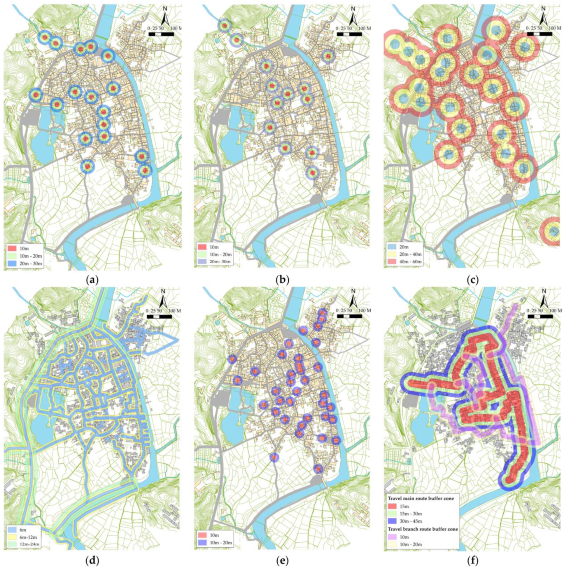
Through the analysis of the above-mentioned geospatial data, the nonfunctioning cables and water supply mains that are directly buried underground are omitted. The buffer zone is set up for the point and line data directly involved in the fire dynamics part. The attenuation range of the factors’ impact on the fire risk is determined in combination with relevant data.
The establishment data of the buffer zone are all fire hazard assessment indices. According to the characteristics of the moving ember and the distribution box (fixed risk source), and in combination with the characteristics of the transmission range of moving ember, three buffer zones (10, 20, 30) are set up (Figure 11a,b) [38]. Three buffer zones (20, 40, 60) are set up for fire hydrants according to the requirements for fire hydrant spacing in the Regulations on the Protection of Famous Historical and Cultural Cities, Towns and Villages (Figure 11c). According to the firefighting distance of micro fire engines, three buffer zones (5, 12, 18) are set up for the roads in the village (Figure 11d) [39]. According to the behavior characteristics of the tourists from other villages and the survey results of the tourist’s behavior, three buffer zones (15, 30, 45) are set up for the travel main route (Figure 11f), as well as two buffer zones (10, 20) for tourist attractions (Figure 11e) and a travel branch route (Figure 11f) [40].
4.3. Assessment Results and Data Interpretation
The collected fire risk assessment index data of Chengkan Village and the established buffer zone were input into ArcGIS for grid calculation, and the following assessment results were obtained:
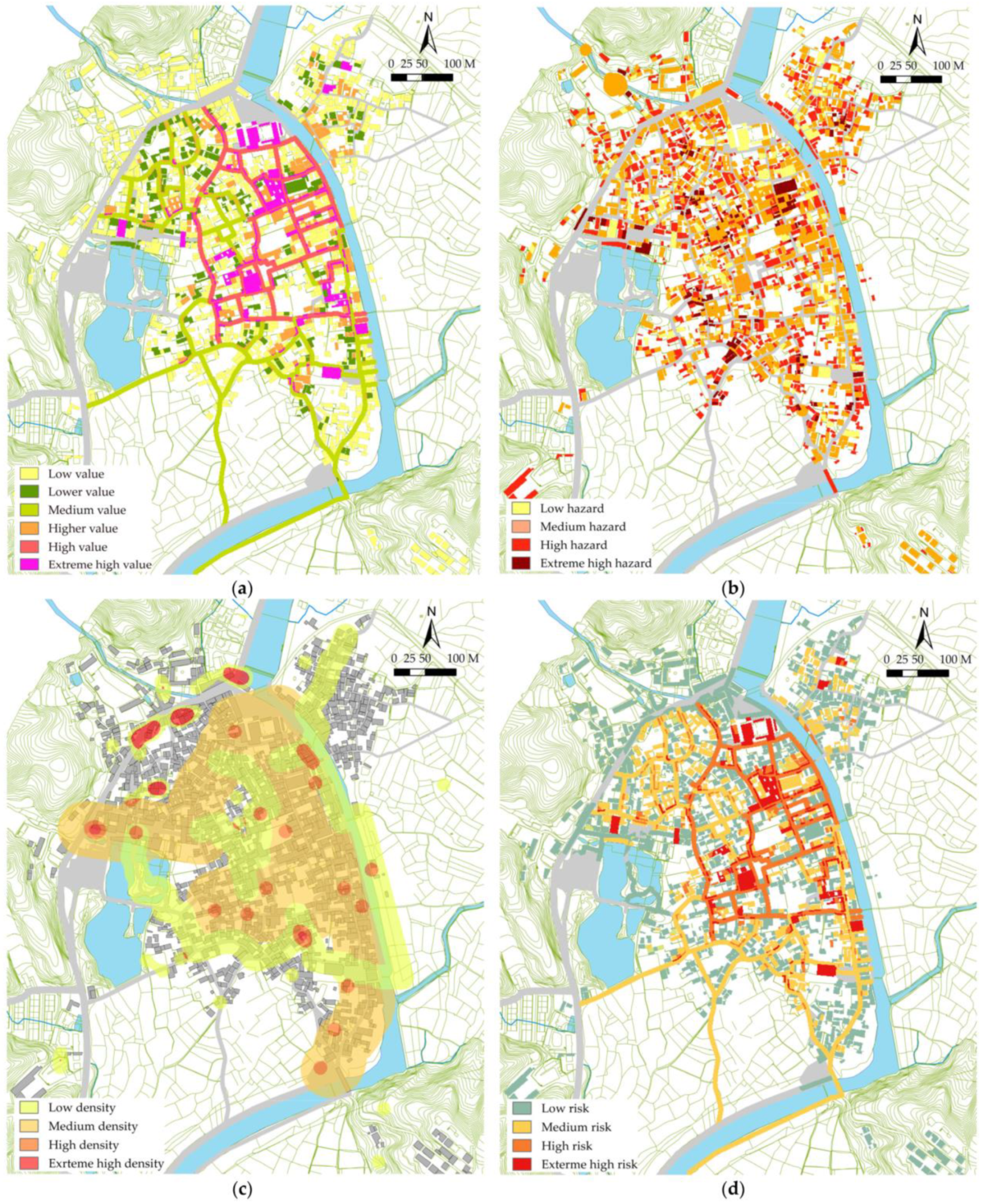
As shown in Figure 12a, the assessment results of the sensitivity of cultural relic value include two factors: the cultural relics building entity and the protection of street space. Extreme high and high value areas are mainly concentrated in the village center and the river in the east, presented as the value attribute of cultural relics that radiates outward along the street, with the core area of the village at the center, which is directly related to the growth mode of the village’s ancestral temple cluster. It is specifically presented as the layout pattern of the high-level cultural relic buildings and first-level protected streets gathered in the core area of the village, and the low-level cultural relic buildings and second-class protected streets scattered around the village’s core.
The results of the village fire hazard assessment are shown in Figure 12b. The fire risk assessment includes all factors of fire dynamics and fire extinguishing. The areas with extreme-high fire risk are mainly concentrated in the core area of the village, its northeast area, and the area adjacent to the main road in the west. Although risk in the high-risk areas is mitigated under the coverage of fire hydrants, there are still many buildings at the village center facing increased risk due to weak fire protection. High-risk and medium-risk areas are mainly distributed in areas with poor protection status of village buildings and interspersed in the core part of the village. Low-risk areas are scattered in villages. Chengkan Village is in a state of medium-high fire risk with complex fire risk factors, various main disaster-causing factors in different areas, and significant potential fire risks.
The assessment results of evacuation accessibility are shown in Figure 12c. The assessment of fire evacuation consists of the occupant density, level of travel route for outsiders, and the facilities of tourist attractions, which correspond to the two groups of people living and traveling in Chengkan Village. Based on the land-use planning of Chengkan, it can be concluded that the locals live in spots along the traffic trunk road around the village center at the edge of the village due to the impact of the cultural relic protection land in the village center. The gathering of local people is often linked to the tertiary industry. Accommodation, entertainment, and other industries also attract crowds of foreigners who belong to densely populated areas. In addition, the main and branch travel routes, and scenic spots constitute a medium-low densely populated area. The overlapping of travel routes and cultural relics also increases the fire risk in this part.
In terms of building fires, heritage-village fires are less challenging to assess than fires in closed spaces, such as high-rise and underground buildings. The combustibles are mainly wood, and the carbon dioxide generated by combustion is also less than the toxic gas generated by modern decoration building fires. Therefore, fire evacuation takes up a smaller proportion in the overall prevention and control of fires in heritage villages. The overall fire evacuation risk of the village is in a medium-low state, suggesting the need for it to be strengthened in local areas.
The sensitivity assessment of cultural relic value, village fire risk assessment, and fire evacuation accessibility assessment were combined with the weight of the three levels of assessment results for overlapping grid processing, and the comprehensive fire risk assessment results of Chengkan Village in Figure 12d were obtained. The areas with extreme-high, high, medium, and low fire risks account for 7.5%, 14.2%, 32.7%, and 45.6% of the village area, respectively.
After several cultural relic buildings in Chengkan Village underwent repairs and renovations to protect them from fires, the overall fire risk was reduced. However, some areas are still under a high fire risk. The extreme-high-risk areas are mainly those structures built using traditional architecture, which are distributed in the village’s core area. The high-risk areas are primarily distributed around the first-class protection streets. Although the ancient buildings in the core area are well protected and have a high fire resistance level, the high value of cultural relics has led to the intensive development of local tourism in the area, and an increase in occupant gathering. There are many fixed risk sources, such as garbage and other moving embers, as well as wires and cables, which contribute to the building’s high-risk state. In contrast, the cultural relic value of the ancient buildings in the south and north of the village is lower than that in the core area, which has a lower tourism development intensity and fewer fire risks. Nevertheless, these buildings need to be repaired and protected. Buildings that are of poor quality and have weak fire-resistance performance, and those under construction and demolition, also have fire safety risks, which put them in a medium-high-risk state.
There are numerous Chinese heritage villages. Compared to other countries in other regions, fire prevention is more difficult in Chengkan Village as it has several ancient buildings. Because of this, Chengkan Village has been listed as an object of protection by many national heritage protection plans in China. The local government has invested huge amounts of money to protect it. However, these investments only make up a drop in the bucket given the extent of what needs to be done to protect the village [41]. According to the survey, the current number of cultural protection units at all levels in Chengkan Village only account for 10% of the current number of ancient buildings in the village. Therefore, 90% of the ancient buildings in the village still remain unprotected, and this percentage of ancient buildings determines the unique historical, cultural landscape of the overall village.
Therefore, limited protection resources must be allocated scientifically, and fire prevention measures must be implemented according to the assessment results.
The attribute of high cultural relic value in extreme-high- and high-risk areas has led to high-intensity development in the tourism industry and occupant gathering. Fires are more likely to cause cultural relic value loss and casualties. It is therefore necessary to strengthen management measures in three aspects: risk sources, infrastructure, and related personnel [42]. In the medium-risk area, the building quality and fire-resistance performance are poor and some buildings are still in the construction and demolition state, which can easily cause fires to start and spread. The ancient buildings in the low-fire-resistance and flammable areas should be repaired and protected, and the fire risk control should be strengthened [43].
5. Discussion
5.1. Innovation and Application Scope of Historical Fire Risk Assessment Model
Scholars have so far conducted insightful research on fire protection and the sustainable development of heritage villages [44], which has mainly been focused on the following processes. First, they classified architectural entities and historical spaces, studied the spatial distribution of various value factors to obtain a more microscopic understanding of the value of historic settlements and cultural relics, and provided guidance for decision-making regarding cultural relic restoration and heritage utilization [45,46,47]. Second, they investigated and measured fire risk factors on the spot to identify and quantify the main disaster factors affecting preservation from different levels. This provided theoretical support for fire prevention measures [5,48]. Third, based on the available risk factor data, they selected the qualitative or quantitative mathematical algorithm appropriate for the data to assess their vulnerability from macro to micro. In doing so, they obtained the overall assessment of heritage-village risk and the weak points [49,50,51].
Fire has the dual attributes of uncertainty and randomness, which are analyzed by simulation and statistical methods, respectively [20]. Fire control measures are implemented based on a complete understanding of fire risk characteristics. The first stage of fire planning involves identifying fire-sensitive areas and assessing the fire risk level. The time and place of village fires are random, and the severity and causes of the damage are related to the distribution of cultural relic value and human factors. It is, thus, necessary to introduce cultural relic value sensitivity and fire evacuation accessibility into simple fire-vulnerability assessment.
The comprehensive assessment model constructed in this paper takes into account the research results obtained above on cultural relic value, quantitative fire factors, vulnerability assessment and other aspects, focusing on the randomness of heritage-village fires; it combines statistics with expert scoring methods, which is more suitable for the complex nonlinear characteristics of heritage-village fire. The comprehensive assessment model includes three parts: fire risk assessment index, index weight comprehensive algorithm, and comprehensive fire risk assessment. (1) The fire risk assessment index system, based on the fire dynamics index, considers the cultural relic value characteristics and tourism function attributes of heritage villages, but also introduces the assessment index of cultural relic attributes and occupant density. The multiple index system makes the assessment results more comprehensive. (2) The index weight algorithm combines the objective Bayes and subjective ANP-SAVEE mathematical models. The Bayes algorithm is based on the topology analysis network of the fault tree. The Bayes network statistical parameters are obtained by inputting known fire-event data, and the objective weight of the index is further calculated. The weight value depends on the causal relationship between the risk factors and fire occurrence, which prevents the error event caused by the artificial prediction of fire. The ANP-SAVEE algorithm is based on the ANP network, and the subjective weight of the index is calculated by collecting expert scoring data. The SAVEE algorithm standardizes the value of the impact factor, and the weight value depends on the relationship between risk factors. It complements the Bayes algorithm, which focuses on causality analysis, and emphasizes the impact of subjective factors on fire. (3) ArcGIS was used to unify and standardize the cultural relic value sensitivity, village fire hazard, and evacuation accessibility. Then, the three were superimposed to create a more comprehensive fire risk assessment, which can provide guidance for risk assessment in heritage villages.
The comprehensive assessment model focuses on measuring the relative risk value and comparing the spatial distribution characteristics of fire risks in different regions. It can also be used to guide the government to prioritize and take targeted fire prevention measures. As the earliest and most typical settlement form, heritage villages cover almost the entire space and form factors of the village layout. The comprehensive assessment model is not only suitable for assessing fire risk in heritage villages but can also be applied to other types of villages. The weights used in the comprehensive evaluation model of this study are based on the fire statistics of Huizhou regional heritage villages as well as the scores of the experts engaged in protection work, which is suitable for evaluating heritage villages in Huizhou cultural areas. The index and weights of the comprehensive assessment model can be adjusted according to the characteristics of the study area and the differences in problems, making it suitable for other kinds of villages and settlement areas with similar fire characteristics and spatial distribution characteristics.
5.2. Limitations and Future Research
The objectivity and accuracy of fire risk assessment not only depend on the scientific index system and the assessment model combining subjectivity and objectivity. Fire occurrence is a dynamic process, and the constituent factors and their states are also changing with the periodic progress of production activities. Determining how to consider the dynamic changes of various factors in fire risk assessment and establishing a dynamic database for data collection are significant development directions that can enable fire risk assessment to identify risks in real time [52].
Further, in the macro type of regional fire risk assessment, fire data exist as points, where a grid is used as the basic assessment unit. However, the assessment scale at the village level is smaller, and the fire data exist in the form of building surface and the fire analysis of the different regions. However, identifying only the risk levels of different areas is not sufficient. The specific fire protection planning and implementation of fire protection measures in heritage villages needs a more detailed and organic risk area division model combined with villages. In our research, we established that the fire risk of Chinese heritage villages is directly related to the layout mode of the settlement clusters of ancestral buildings. Therefore, future research studies should focus on establishing fire risk zoning based on the settlement clusters’ division. This will help obtain a more precise fire assessment unit based on the building clusters and analyzing the main fire factors of each cluster, to implement targeted fire management and measures.
Previously, heritage villages were considered residential property, which have since changed into tourism property. Our attitude has similarly changed towards heritage villages, thereby causing differences in the current firefighting methods and traditional firefighting methods. The value systems of ancient heritage villages are in their way of living. There was a strong desire for regeneration after fires in these villages. The traditional firefighting methods focus on passive fire prevention measures to contain the spread of the fire and to avoid significant economic losses [53]. However, the value of modern heritage villages has gradually changed into one that is cultural and historical, which cannot be regenerated after being damaged. Future prevention and control strategies should focus on active fire prevention measures and more accurately identify the impact of various fire factors on the buildings to protect cultural relics and mitigate fire risks.
Future studies should also focus on the attribute transformation of heritage villages and the different contradictions associated with the starting points of ancient and modern firefighting. Determining the methods by which to organically combine modern and traditional firefighting measures for these heritage villages to effectively carry on their cultural inheritance is an issue that should be considered in future studies.
6. Conclusions
Chinese heritage villages have a history of dancing with fires. The wooden structure characteristics of ancient buildings make fire a common risk when it comes to preserving heritage villages. The excessive proportion of the fixed fire load of ancient buildings makes it difficult to achieve the practical effect of active fire prevention measures. The probability of a fire always remains high, and the possibility of a major fire always exists. It is therefore of great practical significance to strengthen research on the overall fire risk assessment capability and risk spatial distribution characteristics to improve fire prevention and response strategies for cultural heritage protection. According to the fire characteristics of heritage villages, this paper establishes a fire risk assessment model and evaluates it through a case study, which provides the quantitative weight value of the risk factors and acceptable and accurate visual results for fire protection planning and measures.
This research quantifies the impact weight of factors at different levels on the comprehensive fire risk; in the comprehensive fire risk assessment, the fire evacuation accessibility has a small weight value (0.11), consistent with the space type of heritage villages that are not difficult to evacuate. The major work of village fire risk is usually directed in terms of fire prevention and control, composed of the positive and negative factors of disaster (+) and fire (−). Consequently, the weight ratio of fire risk is large (0.42), but the impact on comprehensive fire risk is weakened after the positive and negative factors offset each other. The sensitivity of cultural relics has the largest weight value (0.47) in the comprehensive fire risk assessment. The fundamental attribute of cultural heritage value being a protected object is unchanging. The sensitivity of cultural relics plays a decisive role in the comprehensive fire risk assessment with the highest weight and factors that do not offset each other. This shows that in high cultural value heritage villages where fire protection measures have been taken, the fire hazard distribution will be more uniform, and it is more important to analyze the distribution pattern of cultural relic values and the main disaster-causing factors in different regions, which provides a new perspective for fire risk assessment in genetic villages.
In the specific evaluation case of Chengkan Village, with the core area of the village as the center, the value of cultural relics radiates from high to low along the street. The areas with high fire risk in the village are primarily concentrated in three parts: the core area of the village, the northeast area, and the west area adjacent to the main road. The distribution of high-, medium-, and low-risk areas is relatively uniform. In the village, the areas with high density of personnel are clustered around the tertiary industry, along the transportation trunk road, around the village center, and distributed at the edge of the village; contrastingly, areas with a low density of personnel are clustered around the tourist routes and scenic spots. Overall, the village is in a state of having a high value of cultural relics in the central area, and a low density of personnel with a high risk of fire.
The assessment results in terms of culture relic value sensitivity, village fire hazard, and evacuation accessibility were standardized then superimposed to obtain more comprehensive results on the fire risk assessment of Chengkan Village. The areas with extreme-high, high, medium, and low comprehensive fire risks account for 7.5%, 14.2%, 32.7%, and 45.6% of the area of Chengkan Village, respectively. The extremely high-risk area of Chengkan Village is located in the core ancestral temple building area of the village, and this high-risk area overlaps with the first-class protection street area. Ancestral temple buildings are the most valuable in the heritage villages as the material and spiritual life center of ancient Chinese people. The formation of first-class protection streets is based on the way people gather and grow in a pattern in the village core and radiate outwards along the street. The high-value attributes of cultural relics in the two areas have led to the intensive development of tourism and occupant gatherings. Fire in this area is more likely to cause loss of value of cultural relics and casualties. The medium-risk areas are distributed in both the north and south of the village. Most are ancient residential buildings with low cultural value and second-class protection streets; it is challenging for them to get repair and protection under limited government protection funds.
Along with the fire distribution characteristics discussed above and the feasibility analysis of statistical fire prevention measures based on the fault tree theory, the study concludes that the core area of the Chengkan Village has many sources of fire and a high fire probability. Thus, it should focus on taking active fire prevention measures. It is necessary to strengthen the management and monitoring measures in the three aspects of mobile fuel chips, power infrastructure, and personnel evacuation. Furthermore, to effectively reduce the probability and number of fires, frequent fire drills should be performed for public awareness. The quality of buildings and fire-resistance measures in the northern and southern areas of Chengkan Village is poor. Few are undergoing construction and demolition, with most buildings easily catching and spreading fire. Thus, passive fire prevention measures should be emphasized. The ancient buildings with low fire resistance and more flammable areas should be repaired and protected. The fire risk monitoring of the buildings under construction should be strengthened to reduce the possibility of significant fires and thereby to control the scale and losses due to fire [54].
Author Contributions
Conceptualization, D.W. and S.C.; methodology, D.W. and Q.Z.; software, D.W. and Q.Z.; formal analysis, D.W.; investigation, D.W. and Y.W.; data curation, D.W.; writing—original draft preparation, D.W., Y.W. and S.C.; writing—review and editing, D.W. and S.C.; visualization, D.W. and Q.Z. All authors have read and agreed to the published version of the manuscript.
Funding
This research was funded by the Natural Science Research Program of Anhui Colleges, grant number KJ2021ZD0067.
Data Availability Statement
The data presented in this study are available on request from the corresponding author.
Conflicts of Interest
The authors declare no conflict of interest.
References
- Li, M.; Hasemi, Y.; Nozoe, Y.; Nagasawa, M. Study on strategy for fire safety planning based on local resident cooperation in a preserved historical mountain village in Japan. Int. J. Disaster Risk Reduct. 2021, 56, 102081. [Google Scholar]
- Guo, Z.; Li, S. The planning, development and management of tourism: The case of Dangjia, an ancient village in China. Tour. Manag. 2016, 56, 52–62. [Google Scholar] [CrossRef]
- Wallace, D.; Wallace, R. Consequences of massive housing destruction: The New York City fire epidemic. Build. Res. Inf. 2016, 39, 395–411. [Google Scholar] [CrossRef]
- Xue, L.; Pan, X.; Wang, X. Introduction: Diversity of Cultures, Villages and Architecture. In Traditional Chinese Villages, 1st ed.; Springer: Singapore, 2021; pp. 1–12. [Google Scholar]
- Yuan, C.; He, Y.; Feng, Y.; Wang, P. Fire hazards in heritage villages: A case study on Dangjia Village in China. Int. J. Disaster Risk Reduct. 2018, 28, 748–757. [Google Scholar] [CrossRef]
- Huang, Y.; Li, E.; Xiao, D. Conservation Key points and management strategies of historic villages: 10 cases in the Guangzhou and Foshan Area, Guangdong Province, China. J. Asian Archit. Build. Eng. 2022, 21, 1320–1331. [Google Scholar]
- CHINADAILY. China Improves Fire Safety at Historical Sites. Available online: http://www.chinadaily.com.cn/china/2014-04/09/content_17420740.htm (accessed on 11 December 2022).
- Global Times. Fire in China’s Last Remaining Primitive Tribe under Control, Only 4 Straw Huts Remain Intact. Available online: https://www.globaltimes.cn/page/202102/1215635.shtml (accessed on 11 December 2022).
- Watts, J.M., Jr. Fire protection performance evaluation for historic buildings. J. Fire Prot. Eng. 2001, 11, 197–208. [Google Scholar]
- Watts, J.M., Jr.; Kaplan, M.E. Fire Risk Index for Historic Buildings. Fire Technol. 2001, 37, 167–180. [Google Scholar] [CrossRef]
- Nakamura, K.; Yamada, M. The fire-resistant design of the wooden building. Tokyo Gaiabooks 1998, 11, 197–208. (In Japanese) [Google Scholar]
- Romão, X.; Bertolin, C. Risk protection for cultural heritage and historic centres: Current knowledge and further research needs. Int. J. Disaster Risk Reduct. 2022, 67, 102652. [Google Scholar]
- Tung, S.; Su, H.; Tzeng, C.; Lai, C. Experimental and Numerical Investigation of a Room Fire in a Wooden-Frame Historical Building. Int. J. Archit. Herit. 2020, 14, 106–118. [Google Scholar] [CrossRef]
- Yang, L.; Liu, W.; Liu, Q.; Liu, S.; Tong, Y.; Xiao, Z.; Meng, T.; Wei, W.; Zhang, W. Full-scale Fire Experiment of Timber Buildings in Rural Areas of Southwest China. Int. J. Archit. Herit. 2022, 16, 1–20. [Google Scholar]
- Matsumita, K.; Oikawa, K. Quantitative Analysis of Fire Spreading Potential for Surrounding Areas of Cultural Properties in Kyoto City. J. Asian Archit. Build. Eng. 2013, 12, 269–276. [Google Scholar] [CrossRef] [Green Version]
- Granda, S.; Ferreira, T.M. Large-scale Vulnerability and Fire Risk Assessment of the Historic Centre of Quito, Ecuador. Int. J. Archit. Herit. 2021, 15, 1043–1057. [Google Scholar] [CrossRef]
- Li, C.; Sung, Y.; Lin, Y.; Hsiao, G.L. Evaluating the severity of building fires with the analytical hierarchy process, big data analysis, and remote sensing. Nat. Hazards 2020, 103, 1843–1856. [Google Scholar]
- Chen, X.; Xie, W.; Li, H. The spatial evolution process, characteristics and driving factors of traditional villages from the perspective of the cultural ecosystem: A case study of Chengkan Village. Habitat Int. 2020, 104, 102250. [Google Scholar] [CrossRef]
- China Global Television Network. Ming Dynasty Architecture in Chengkan Village. Available online: https://news.cgtn.com/news3d3d414e7849544f31457a6333566d54/index.html (accessed on 11 December 2022).
- Fan, W.; Sun, J.; Lu, S. Fundamentals of fire dynamics and control technology. In Fire Risk Assessment Methodology, 1st ed.; Science Press: Beijing, China, 2004; pp. 44–55. [Google Scholar]
- Kong, D.; Lu, S.; Xie, Q.; Lo, S.; Kang, S.; Lu, S. Fuzzy Risk Assessment for Life Safety under Building Fires. Fire Technol. 2014, 50, 977–991. [Google Scholar]
- Taher Tolou Del, M.S.; Saleh Sedghpour, B.; Kamali Tabrizi, S. The semantic conservation of architectural heritage: The missing values. Herit. Sci. 2020, 8, 70. [Google Scholar] [CrossRef]
- Fu, J.; Zhou, J.; Deng, Y. Heritage values of ancient vernacular residences in traditional villages in Western Hunan, China: Spatial patterns and influencing factors. Build. Environ. 2021, 188, 107473. [Google Scholar]
- García-Esparza, J.A.; Tena, P.A. A GIS-based methodology for the appraisal of historical, architectural, and social values in historic urban cores. Front. Archit. Res. 2020, 9, 900–913. [Google Scholar]
- Du, F.; Okazaki, K.; Ochiai, C. Disaster coping capacity of a fire-prone historical dong village in China: A case study in Dali Village, Guizhou. Int. J. Disaster Risk Reduct. 2017, 21, 85–98. [Google Scholar]
- Östman, B.; Brandon, D.; Frantzich, H. Fire safety engineering in timber buildings. Fire Saf. J. 2017, 91, 11–20. [Google Scholar] [CrossRef] [Green Version]
- Xie, Q.; Xiao, J.; Gardoni, P.; Hu, K. Probabilistic Analysis of Building Fire Severity Based on Fire Load Density Models. Fire Technol. 2019, 55, 1349–1375. [Google Scholar]
- Li, J.; Li, H.; Zhou, B.; Wang, X. Investigation and Statistical Analysis of Fire Loads of 83 Historic Buildings in Beijing. Int. J. Archit. Herit. 2022, 14, 471–482. [Google Scholar] [CrossRef]
- Nguyen, D.; Kaye, N.B. The role of surrounding buildings on the accumulation of embers on rooftops during an ember storm. Fire Saf. J. 2022, 131, 103624. [Google Scholar] [CrossRef]
- Ghassempour, N.; Tannous, W.K.; Agho, K.E.; Avsar, G.; Harvey, L.A. The Impact of Reduced Fire Risk Cigarettes Regulation on Residential Fire Incidents, Mortality and Health Service Utilisation in New South Wales, Australia. Int. J. Environ. Res. Public Health 2022, 19, 12481. [Google Scholar]
- Xin, J.; Huang, C. Fire risk assessment of residential buildings based on fire statistics from China. Fire Technol. 2014, 50, 1147–1161. [Google Scholar] [CrossRef]
- Kumar, B.; Bhaduri, S. Disaster risk in the urban villages of Delhi. Int. J. Disaster Risk Reduct. 2018, 31, 1309–1325. [Google Scholar] [CrossRef]
- Misaki, S.; Tanaka, K. City shapes that maximize the number of walking-only trips based on Manhattan distance. J. Adv. Mech. Des. Syst. Manuf. 2020, 14, jamdsm0075. [Google Scholar]
- Chen, W.; Zhou, Y.; Zhou, E.; Xiang, Z.; Zhou, W.; Lu, J. Wildfire Risk Assessment of Transmission-Line Corridors Based on Naïve Bayes Network and Remote Sensing Data. Sensors 2020, 21, 634. [Google Scholar] [CrossRef]
- Shu, X.; Yan, J.; Hu, J.; Wu, J.; Deng, B. Risk assessment model for building fires based on a Bayesian network. J. Tsinghua Univ. Sci. Technol. 2020, 60, 321–327. (In Chinese) [Google Scholar]
- Chen, W.; Shirzadi, A.; Shahabi, H.; Ahmad, B.B.; Zhang, S.; Hong, H.; Zhang, N. A novel hybrid artificial intelligence approach based on the rotation forest ensemble and naïve Bayes tree classifiers for a landslide susceptibility assessment in Langao County, China. Geomat. Nat. Hazards Risk 2017, 8, 1955–1977. [Google Scholar]
- Tadić, S.; Zečević, S.; Krstić, M. A novel hybrid MCDM model based on fuzzy DEMATEL, fuzzy ANP and fuzzy VIKOR for city logistics concept selection. Expert Syst. Appl. 2014, 41, 8112–8128. [Google Scholar]
- Kaufman, M.M.; Rosencrants, T.; Frantzich, H. GIS method for characterizing fire flow capacity. Fire Saf. J. 2015, 72, 25–32. [Google Scholar] [CrossRef]
- Stipić, M.; Prodanović, D.; Kolaković, S. onalisation and reliability improvement of firefighting systems—The Novi Sad case study. Urban Water J. 2009, 6, 169–181. [Google Scholar]
- Nishino, T.; Tanaka, T.; Hokugo, A. An evaluation method for the urban post-earthquake fire risk considering multiple scenarios of fire spread and evacuation. Fire Saf. J. 2012, 54, 167–180. [Google Scholar] [CrossRef]
- Traditional Village. Protection List of Traditional Villages. Available online: http://www.chuantongcunluo.com/index.php/Home/gjml/gjml/wid/587.html (accessed on 11 December 2022). (In Chinese).
- Cvetković, V.M.; Dragašević, A.; Protić, D. Fire safety behavior model for residential buildings: Implications for disaster risk reduction. Int. J. Disaster Risk Reduct. 2022, 76, 102981. [Google Scholar] [CrossRef]
- Laranjeira, J.P.S.; Cruz, H.; Pinto, A.P.F.; Santos, C.P. Reaction to fire of existing timber elements protected with fire retardant treatments: Experimental assessment. Int. J. Archit. Herit. 2015, 9, 866–882. [Google Scholar]
- Nguyen, A.T.; Truong, N.S.H.; Rockwood, D.; Le, A.D.T. Studies on sustainable features of vernacular architecture in different regions across the world: A comprehensive synthesis and evaluation. Front. Archit. Res. 2019, 8, 535–548. [Google Scholar] [CrossRef]
- Luo, Y.; Qi, L. Construction and practice of a conservation plan implementation evaluation system for historic villages. J. Asian Archit. Build. Eng. 2019, 18, 351–361. [Google Scholar]
- Niu, Y.; Mi, X.; Wang, Z. Studies on sustainable features of vernacular architecture in different regions across the world: A comprehensive synthesis and evaluation. Front. Archit. Res. 2021, 10, 729–740. [Google Scholar]
- Ruiz-Jaramillo, J.; Muñoz-González, C.; Joyanes-Díaz, M.D.; Jiménez-Morales, E.; López-Osorio, J.M.; Barrios-Pérez, R.; Rosa-Jiménez, C. Heritage risk index: A multi-criteria decision-making tool to prioritize municipal historic preservation projects. Frontiers of Architectural Research. Front. Archit. Res. 2020, 9, 403–418. [Google Scholar] [CrossRef]
- He, Y.; Park, L.A. A statistical analysis of occurrence and association between structural fire hazards in heritage housing. Fire Saf. J. 2017, 90, 169–180. [Google Scholar] [CrossRef]
- Salazar, L.G.F.; Romao, X.; Paupério, E. Review of vulnerability indicators for fire risk assessment in cultural heritage. International Journal of Disaster Risk Reduction. Int. J. Disaster Risk Reduct. 2021, 60, 102286. [Google Scholar]
- Neto, J.T.; Ferreira, T.M. Assessing and mitigating vulnerability and fire risk in historic centres: A cost-benefit analysis. J. Cult. Herit. 2020, 45, 279–290. [Google Scholar]
- Tripathi, A.; Rai, C.R. Seismic vulnerability assessment and fragility analysis of stone masonry monastic temples in Sikkim Himalayas. Int. J. Archit. Herit. 2019, 13, 257–272. [Google Scholar]
- Xu, J.; Liu, X.; Su, Y.; Huang, Q. Study on dynamic risk assessment method of building fire based on Bayesian network. J. Saf. Sci. Technol. 2019, 15, 138–144. (In Chinese) [Google Scholar]
- Li, J. Chengkan Village of the ancient Fire Museum. In Exploration of Huizhou Ancient Folk Houses, 1st ed.; Shanghai Science and Technology Press: Shanghai, China, 2003; pp. 45–59. (In Chinese) [Google Scholar]
- Du, L. Building fire protection technology. In Fire Risk Assessment Method and Application Case, 1st ed.; Springer: Singapore, 2011; pp. 20–30. [Google Scholar]
Figure 1.
Identification of the study area. (a) The Huizhou culture region in Anhui. (b) The Chengkan Village in Huizhou culture region. (c) The Chengkan Village conservation planning.
Figure 1.
Identification of the study area. (a) The Huizhou culture region in Anhui. (b) The Chengkan Village in Huizhou culture region. (c) The Chengkan Village conservation planning.

Figure 2.
Photos of Chengkan Village. (a) Overall view. (b) Luo DongShu Ancestral Temple. (c) Ming Dynasty architecture.
Figure 2.
Photos of Chengkan Village. (a) Overall view. (b) Luo DongShu Ancestral Temple. (c) Ming Dynasty architecture.

Figure 3.
Fire risk assessment model flow chart.

Figure 4.
Index system factor logical relationship.

Figure 5.
The Bayesian network directed acyclic graph.

Figure 6.
Bayes fire risk assessment index topological network.

Figure 7.
Netica-Bayes topology network weight calculation result.

Figure 8.
(a) Typical ANP network structure; (b) ANP fire risk assessment index network.

Figure 9.
Yaahp-ANP network analytic hierarchy model weight calculation result.

Figure 10.
Fire risk assessment vector data of Chengkan Village. (a) The plan for Chengkan Village; (b) classification of protection levels of cultural relic; (c) classification of cultural relic protection elements; (d) environmental sanitation distribution map; (e) building renovation mode diagram; (f) wire and cable distribution diagram; (g) building height distribution diagram; (h) building quality distribution diagram; (i) layout of water supply and fire protection; (j) road traffic distribution map; (k) travel route map.


Figure 11.
Establishment of the index buffer zone. (a) Moving ember buffer zone; (b) electric box buffer zone; (c) hydrant buffer zone; (d) micro fire engines buffer zone; (e) occupant gathering point buffer zone; (f) travel route buffer zone.
Figure 11.
Establishment of the index buffer zone. (a) Moving ember buffer zone; (b) electric box buffer zone; (c) hydrant buffer zone; (d) micro fire engines buffer zone; (e) occupant gathering point buffer zone; (f) travel route buffer zone.

Figure 12.
Different aspects of Chengkan Village assessment. (a) Cultural relic value sensitivity assessment; (b) village fires hazard assessment; (c) evacuation accessibility assessment; (d) comprehensive fire risk assessment.
Figure 12.
Different aspects of Chengkan Village assessment. (a) Cultural relic value sensitivity assessment; (b) village fires hazard assessment; (c) evacuation accessibility assessment; (d) comprehensive fire risk assessment.


Table 1.
Disasters in the heritage villages in Huizhou culture core region from 2000 to 2020.
| Year | Region | Village | Disaster | Destroy Records |
|---|---|---|---|---|
| 2002 | Huizhou District | Chengkan Village | Fire | Ming Dynasty “Jinshi Mansion” building collapsed. |
| 2003 | Huizhou District | Chengkan Village | Windstorm | Three stories Luohuitan former residence of the Ming Dynasty demolished. |
| 2010 | Huizhou District | Chengkan Village | Fire | Centennial burning of ancient dwellings in the late Qing and early Ming Dynasty. |
| 2012 | Tunxi County | Nanxinan Village | Fire | The ancient building, “Nanmu Hall,” from the Ming Dynasty was burned down. |
| 2013 | Qimen County | Kengkou Village | Fire | The ancient stage of “Huiyuantang” from the Ming Dynasty burned due to the failure of electric lines. |
| 2013 | Huizhou District | Chengkan Village | Flood | The gable wall and other parts of Baolunge Temple collapsed after it was flooded with waters reaching a height of 1.6 m. |
| 2015 | She County | Poshan Village | Fire | Centennial’s ancient building “Midday Room” was gutted by garbage ignition. |
| 2019 | Jing County | Huangtian Village | Fire | A wire circuit failure resulted in the burning of a 200 square meter area of “Yangchuan house” (Duchengtang). |
| 2020 | Huizhou District | Qiankou Village | Fire | Electrical appliances ignited a fire in a house, causing one death due to suffocation from smoke. |
Table 2.
Fire risk assessment index.
| Goal Layer | Fire Dynamic Layer | First Level Index Layer | Risk Factor Conceptual Layer | Secondary Level Index Layer | |
|---|---|---|---|---|---|
| Comprehensive Fire Risk Assessment A1 | Cultural Relic Value Sensitivity B1 | Cultural Value C1 | Classification Protection Levels D1 | Historic Architecture | Cultural relic architecture, general historical architecture, |
| General Building | retention building, renovation building | ||||
| Classification Protection Elements D2 | Spatial Element | First class protection street, second class protection street, general stone road, | |||
| Natural Element | Ancient tree, landscaped courtyard | ||||
| Village Fires Hazard B2 | Firing C2 | Sanitation D3 | Moving Ember | Litter bin, waste container | |
| Daily cleaning road | |||||
| Building Renovation Mode D4 | Fixed Ember | Preservation, maintenance, reformation, dismantle | |||
| Electric Power D5 | Fixed Risk Source | Substation, junction box, switching box | |||
| Fire Growth C3 | Building Quality D6 | Fire Resistance Level | Intact, general, ruin | ||
| Building Volume D7 | Fire Load | One story, two stories, three stories and above | |||
| Outfire C4 | Fire Control D8 | Fire Force | Well, fire hydrant, fire cistern | ||
| Evacuation Accessibility B3 | Space Accessibility C5 | Traffic Road D9 | Linear Space | Town road, main road, secondary road | |
| Areal Space | Square, yard, parking area | ||||
| Occupant Density C6 | Travel Route D10 | Outdoor Pedestrian Flow | Travel main route, travel branch route, scenic spots | ||
| Indoor Pedestrian Flow | Tourist center, service area | ||||
| POI Thermal Diagram D11 | Resident Population | Entertainment, dining, residence | |||
Table 3.
Netica index simplification form.
| Number | A1 | B1 | B2 | B3 | C1 | C2 | C3 | D1 | D2 |
| Simplify Condition | Large Fire Damage | Cultural Relics Damage | Fires Occur | Casualties | Worth Cultural Value | Building Fire | Fire Growth | Protected Building | Protected Element |
| Number | D3 | D4 | D5 | D6 | D7 | D8 | D9 | D10 | D11 |
| Simplify Condition | Ember Causes Fire | Under Repair | Electric Fire | Building Fire Resistance | Building Volume | Fire Rescue | Traffic | Travel Route | Densely Populated |
Table 4.
Importance index coefficient table.
| Importance | D1 | D2 | D3 | D4 | D5 | D6 | D7 | D8 | D9 | D10 | D11 |
|---|---|---|---|---|---|---|---|---|---|---|---|
| structural | 6.631 | 6.631 | 0.008 | 0.002 | 0.008 | 0.171 | 0.324 | 0.451 | 0.211 | 1.481 | 0.211 |
| probability | 7.317 | 7.317 | 0.012 | 0.006 | 0.012 | 0.061 | 0.196 | 0.229 | 0.794 | 1.215 | 0.794 |
| critical | 7.317 | 7.317 | 1.215 | 0.794 | 0.794 | 0.299 | 0.196 | 0.061 | 0.012 | 0.012 | 0.006 |
| Importance indexes scale: | |||||||||||
| Low importance | Medium importance | High importance | Extreme high importance | ||||||||
| 0.000 | 0.100 | 0.500 | 1.500 | 7.500 | |||||||
Table 5.
Fire risk assessment index weight.
| Categories Index | Category Weight | Subclass | Trend | Bayes Weight βi′ | ANP Weight βi″ | Synthesis Weight Wi | Basic Type (1–9 Scale Value Assignment) |
|---|---|---|---|---|---|---|---|
| Cultural Relic Value Sensitivity B1 | 0.47 | Classification Protection Level D1 | + | 0.401 | 0.125 | 0.264 | Cultural relic architecture, general historical architecture, retention building, renovation building; score separately 9, 6, 3, 1 |
| Classification Protection Element D2 | + | 0.401 | 0.021 | 0.211 | First class protection street, second class protection street, ancient tree, landscaped courtyard, general stone road; score separately 9, 6, 5, 3, 1 | ||
| Village Fires Hazard B2 | 0.42 | Sanitation D3 | + | 0.034 | 0.039 | 0.037 | Litter bin, waste container; score buffer separately 9, 6, 3 |
| - | Daily cleaning road; score buffer separately 5, 3 | ||||||
| Building Renovation Mode D4 | + | 0.022 | 0.079 | 0.052 | Preservation, maintenance, reformation, dismantle; score separately 1, 3, 6, 9 | ||
| Electric Power D5 | + | 0.022 | 0.098 | 0.062 | Substation, junction box, switching box; score buffer separately 9, 6, 3 | ||
| Building Quality D6 | + | 0.010 | 0.118 | 0.064 | Intact, general, ruin; score separately 3, 6, 9 | ||
| Building Volume D7 | + | 0.011 | 0.029 | 0.021 | One story, two stories, three stories and above; score separately 3, 6, 9 | ||
| Fire Control D8 | - | 0.008 | 0.356 | 0.182 | Well, fire hydrant; score buffer separately 9, 6, 3 | ||
| Evacuation Accessibility B3 | 0.11 | Traffic Road D9 | - | 0.022 | 0.058 | 0.041 | Town road, main road, secondary road; score buffer separately 9, 6, 3 |
| Square, yard, parking area; score buffer separately 9 6, 3 | |||||||
| Travel Route D10 | + | 0.034 | 0.028 | 0.031 | Scenic spot, travel main route, travel branch route; score buffer separately 9, 6, 3 | ||
| Tourist center, service area; score buffer separately 9, 6, 3 | |||||||
| POI Thermal Diagram D11 | + | 0.022 | 0.047 | 0.035 | Occupant density grading; score separately 9, 6, 3, 1 |
Disclaimer/Publisher’s Note: The statements, opinions and data contained in all publications are solely those of the individual author(s) and contributor(s) and not of MDPI and/or the editor(s). MDPI and/or the editor(s) disclaim responsibility for any injury to people or property resulting from any ideas, methods, instructions or products referred to in the content. |
© 2023 by the authors. Licensee MDPI, Basel, Switzerland. This article is an open access article distributed under the terms and conditions of the Creative Commons Attribution (CC BY) license (https://creativecommons.org/licenses/by/4.0/).
Share and Cite
MDPI and ACS Style
Wu, Y.; Chen, S.; Wang, D.; Zhang, Q. Fire Risk Assessment of Heritage Villages: A Case Study on Chengkan Village in China. Fire 2023, 6, 47. https://0-doi-org.brum.beds.ac.uk/10.3390/fire6020047
AMA Style
Wu Y, Chen S, Wang D, Zhang Q. Fire Risk Assessment of Heritage Villages: A Case Study on Chengkan Village in China. Fire. 2023; 6(2):47. https://0-doi-org.brum.beds.ac.uk/10.3390/fire6020047
Chicago/Turabian StyleWu, Yunfa, Sarula Chen, Dongzhe Wang, and Qiang Zhang. 2023. "Fire Risk Assessment of Heritage Villages: A Case Study on Chengkan Village in China" Fire 6, no. 2: 47. https://0-doi-org.brum.beds.ac.uk/10.3390/fire6020047