
Shipwrecks’ Underwater Mysteries—Identifying Commonalities Out of Globally-Distributed Knowledge


Department of Geography and Regional Planning, School of Rural, Surveying and Geoinformatics Engineering, National Technical University of Athens (NTUA), Heroon Polytechniou Str., 9, Zographou Campus, 15780 Athens, Greece
*
Author to whom correspondence should be addressed.
Heritage 2021, 4(4), 3949-3969; https://0-doi-org.brum.beds.ac.uk/10.3390/heritage4040217
Submission received: 31 August 2021
/
Revised: 7 October 2021
/
Accepted: 20 October 2021
/
Published: 26 October 2021
(This article belongs to the Special Issue Indulging in Preservation and Sustainable Management of Land and Maritime Cultural Resources in Current Times)
Abstract
:Tourism trends towards authentic, experience-based products have brought to the forefront lesser-known destinations, e.g., small and medium-sized Mediterranean islands. These can gain competitiveness on the ground of their distinguished land and Underwater Cultural Heritage (UCH), thus opening up new directions for their future sustainable development. Sustainable exploitation of UCH, though, calls for dedicated planning endeavors and respective UCH data acquisition/management. However, while the planning discipline can offer effective approaches and tools for properly handling cultural heritage, a deficit of sufficient, pertinent and well-documented UCH data is noticed, e.g., data on shipwrecks as part of UCH. The latter is the focus of this work, aiming, as a first step, to illuminate aspects of a shipwreck database, relevant to planners’ requests. Towards this end, global-wide distributed knowledge is explored in an effort to identify potentialities and limitations, content commonalities, shipwreck attributes so far recorded, (spatial) planning requirements, to name but a few. Knowledge acquired from this exploration can feed conceptualization of a planning-oriented shipwreck database. This can be replicable to various national/regional contexts; and is capable of providing well-structured shipwrecks’ content that can steer strategic planning efforts towards authentic ensembles of people’s history and culture in remote and less-privileged Mediterranean islands.
1. Introduction
Rapid globalization and intense mobility patterns, coupled with the tremendous potential offered by the technological advances as enablers of heavy internet- and social media-based interaction, have deeply influenced the way consumers—the demand side—behave and public/private economic sectors—the supply side—, deliver their products/services around the globe. Among the sectors that have been more radically affected by such globally evolving trends lies tourism, within which the above pervasive evolutions, i.e., globalization, mobility patterns and technology, have a highly permeating role in both the demand and the supply side, but also in the destinations.
Speaking from the tourism demand point of view, the above evolutions have broadened travelers’ opportunities with regard to the multiplicity of available destination options and the ways they are exploring them, planning and booking their trips, consuming and experiencing travel and tourism products, and evaluating tourism experiences [1], to name a few. Such evolutions have also initiated important changes in the consumption patterns, clearly demonstrating a shift towards more personalized and, most importantly, authentic and experience-based tourism preferences [2,3,4,5].
Contemporary travelers are mature consumers, i.e., more experienced, sophisticated, educated and knowledgeable, independent and quite demanding, and mostly familiar with Information and Communication Technologies (ICTs) [3,6]. When travelling to a destination, they seek to be inspired by both the place they visit and the local people they meet, i.e., they expect to experience in a deeper, more sensational, and personalized way both the destination and the indigenous community [7]. They search for the ‘real’ and ‘authentic’ experience [8], with authenticity being synonymous to value, especially in heritage tourism. Also, as Kim and Jamal claim, a destination’s authenticity is realized by a traveler not as an object-related perception, but as a perception grasped by ‘being a part of’ [9] (p. 93), thus rendering the experience memorable.
The desire for authentic experiences is the outcome of a gradual change of the motivation to travel from the need to ‘escape daily routine’ to a desire to ‘experience and learn’ in the selected destination [3,6,10]. This change goes hand in hand with the emerging ‘experience economy’, a term firstly coined by Pine and Gilmore [11]; and being onwards subject to extensive discourse within the research community [12,13,14,15]. In fact, Pine and Gilmore [11], in their ground-breaking contribution, claim that a certain transition to a new economy, the ‘experience economy’, is taking place. Within this new economic paradigm, ‘experience’ constitutes a repository of value; and a property that should be embedded in all commercialized products and services in order for competitive advantage to be established by businesses or destinations. As value, Pine and Gilmore [11] define the mental and physical engagement of a traveler into the experience provided by the destination. This, in turn, implies that such an experience is subjective, i.e., it remains within the realm of each single consumer [16] and can be featured as memorable or unforgettable [10,17,18], meaningful [6,12], and valuable [13], to name a few often used terms.
Transition to the new ‘experience economy’ paradigm has also fueled and properly oriented reactions in the supply side, i.e., tourism businesses and destinations. Such reactions aim at meeting changing visitors’ demand and authenticity expectations. Indeed, in front of this new challenge, the tourism industry and destinations are forced to redesign, reorient, reinvent, and re-engineer processes in order to address customer requests for spiritual, memorable, and holistic destination products [15,19]. However, despite the fact that such a ‘tourism experience’ can, to a certain degree, be designed, processed, or facilitated, relevant research supporting the emergence of experience-based products is rather limited [16,20].
Cultural tourism, as a prominent form strongly interwoven with visitor experience, seems to gain ground in Pine and Gilmore’s [11] concept of ‘experience economy’. This is justified by its very principal purpose, i.e., the sharing of messages inherent in tangible and intangible dimensions of Cultural Heritage (CH), as these are featured by landscapes, buildings, art collections, arts, cultural identity, local tradition, language, etc. [21]. This purpose is prevalent in the very comprehensive definition provided by the UNWTO in the 22nd Session of the General Assembly in 2017, demarcating cultural tourism as “…a type of tourism activity in which the visitor’s essential motivation is to learn, discover, experience and consume the tangible and intangible cultural attractions / products in a tourism destination” [22] (p. 30). According to this definition, cultural tourism capitalizes on the attractions of a specific destination that are both of tangible, i.e., material or disposing a spatial ‘footprint’, and intangible nature, i.e., intellectual, spiritual and emotional. Among the intangible attributes, a salient position is held by living cultures, marked by local lifestyles, value systems, beliefs, and traditions. This, in essence, stresses the important role of indigenous communities as the producers and safeguards of these living cultures; and an important part of hospitality and visitor’s authentic experiences. As such, indigenous communities (should) constitute main actors in decision-making processes as to the way this heritage will be transformed into authentic cultural tourism products [23,24].
In fact, culture and tourism are two sectors that have always been conceived as strongly interwoven [25]. As such, they have steadily attracted the interest of the research community in illuminating various aspects of them, such as the motivation for cultural consumption and authentic experience; in addition to heritage protection and preservation, as the locomotive and the driving force of cultural heritage tourism. Sustainability concerns of destinations, currently at the epicenter of research endeavors in alignment with the United Nations’ Agenda on Sustainable Development Goals (SDGs) [26,27], are also giving prominence to cultural tourism, as an alternative form positively affecting destinations’ economies [28]; while ensuring protection and preservation of valuable cultural assets [19,29]. Taking into account the steadily and firmly rising interest in this tourism form and its various niches (e.g., diving tourism, battlefield tourism, fishing tourism, gastronomy, ecotourism) [25,30,31], many destinations around the globe are today striving to be established as experience-based cultural tourism destinations and compete in the challenging and evolving paradigm of the ‘experience economy’ [16].
In the continuously blossoming tourism market that brings out cultural tourism as a prevalent option for gaining competitiveness and sustaining more environmentally and socially-responsible tourism development pathways, the Mediterranean Region holds a rather high position [32,33,34]. In fact, tourism destinations in this region are rating quite high in consumer preferences, as witnessed by UNWTO’s data for the year 2016 [35]. According to these data, Mediterranean destinations in 2016 were hosts of more than 192 million tourists and 70% of the total European tourism arrivals all year round. This is grounded on the spectacular scenery that is built upon the remarkable natural and cultural richness and diversity of the Mediterranean’s mainland, which is most important for the tourism sector’s coastal, insular, and marine counterparts. Concurrently, however, this area is also marked as a hot spot in sustainability terms in many respects, e.g., overtourism, urbanization, water scarcity, climate change, environmental degradation, floods and droughts [33,36,37,38,39]. Such threats menace the distinguishable land and underwater cultural heritage of the Mediterranean region (abbreviated as CH and UCH, respectively, in the following of this work), namely the key resources upon which cultural tourism in the destinations of this area is built, but also the destinations per se, e.g., in coastal areas. Confrontation of these threats calls for collaborative as well as firmly planned and implemented endeavors of the surrounding territories and states [39] in seeking to attain sustainability and resilience objectives of this spectacular place on earth, cradle of global culture and civilization, in a way that respects the region’s capacity limits. The two currently overarching policy goals, namely sustainability and resilience, in case of the highly endangered marine and coastal areas (insular areas included) of the Mediterranean Region, i.e., areas of key concern for the tourism sector, seem to be a high policy priority in this respect. This is confirmed by the first objective of the Mediterranean Strategy for Sustainable Development 2016–2025, addressing the need to “Ensure sustainable development in marine and coastal areas” [39].
Islands in the Mediterranean, as geographically distinct land compartments and hosts of extraordinary natural and cultural assets [32], have so far been highly distinguished as competitive tourism nodes in the global tourism arena [33,40]. Their attractiveness is grounded mostly on the sea element, with the majority of tourism activity taking part in the coastal and near shore zone, displaying thus a mass and unsustainable tourism model [41]. Insularity drawbacks, negatively affecting the developmental trajectories of insular regions [42,43,44], have rendered tourism a way out of economic and social stagnation; and a main pillar of income, employment, and wealth in insular economies [45]. However, islands seem to be currently highly vulnerable areas in terms of: overtourism and related pressures that go beyond the carrying capacity of ecosystems; external crises such as the one of COVID-19, a tremendously impactful situation for the global tourism sector; climate change and rising sea levels and the emerging risks to islands and (their) coastal land; to name just a few of the most piercing risks these territories are confronted with [33,34,46,47,48,49]. As such, the need to reconsider the current islands’ local development models and reposition them as alternative, authentic and experience-based cultural tourism destinations, grounded on their tangible and intangible cultural assets [24], seems to be rather a one-way and urgent direction.
Many of the Mediterranean islands have been places of strategic importance for political, commercial, cultural, military, etc. purposes [42,50,51]. An example is the Leros Island, Greece, which, due to its strategic geopolitical position, was occupied by Italians and used as the main military basis for surveillance purposes in the Mediterranean Sea [42,44,51,52,53]. Also of critical importance, was the embroilment of many Mediterranean islands, as counterparts of the respective states, in fatal World War (WW) events, namely WWI and especially WWII. This embroilment is witnessed by the abundance of UCH remnants, e.g., sunken martial equipment, ship or plane wrecks, resting in peace at the bottom of the Mediterranean Sea. In certain cases, such an entrenchment was also marked by important land (military and other) remains, as was the case of Leros due to the Italian occupation [42]. In this respect, the uniqueness of cultural assets of island regions should be stressed in terms of the value of experiential products they can offer to their visitors.
Speaking of the UCH wealth of island regions in the Mediterranean, in particular, data demonstrates that this is really huge. Indeed, as noticed in wreck.eu [54], an open crowdsourcing web-platform gathering data on ship and plane wrecks from around the world, there are over 15,000 ship and plane wrecks in the Mediterranean Sea. These represent a wide range of historical periods from the ancient to contemporary times. Taking this into account, neighboring places to these UCH sites, i.e., coastal and island regions, can have a prominent position as attractive and authentic UCH-related, e.g., battlefield and diving, cultural tourism destinations. Such a perspective constitutes a promising alternative tourism option, taking into consideration the globally rising interest in these specific tourism niches.
However, UCH sites that are already under such exploitation are rather few, compared to the real potential [53]. Additionally, a large number of these wrecks remains unknown and unexplored; while from those known, the majority of them is not yet documented and, thus, largely unprotected and untapped. This ‘hidden treasure’ and the added value that can be ‘produced’ out of this in cultural, political, societal, environmental, economic, etc. terms, needs to be brought to the surface in order for a twofold purpose to be served, namely: the support of heritage-led perspectives of remote and lagging-behind island regions in the Mediterranean; and the spread to society of information on fatal errors of the past for paving a more peaceful and solidary future.
Sustainable exploitation of UCH sites, as part of the islands’ cultural tourism authentic and immersive experiences, presupposes considerable effort to be devoted in conducting UCH documentation studies as a first step; and heritage planning exercises that address the preservation and sustainable exploitation of such resources [55] as a second one. Managing CH assets in general and UCH in particular in both of these steps is a data-intensive process, based on the integration and interpretation of a wide range of spatially-related as well as quantitative and qualitative data [56].
Based on the aforementioned discussion, the focus of this paper is on UCH in insular regions in the Mediterranean, with a specific interest on shipwrecks in general and historical shipwrecks in particular that are part of fatal incidents of WWI and especially WWII. According to the authors’ point of view, being the one of (spatial) planning, UCH constitutes a valuable cultural resource for setting up authentic and immersive cultural tourism experiences as a means for serving heritage-led developmental objectives of these less-privileged and vulnerable regions; ensuring concurrently the protection/preservation of this scarce resource and its sustainable exploitation for producing wealth and prosperity. As this implies a certain spatial/developmental planning effort in order to be accomplished, a prerequisite of such an effort is data availability on UCH.
Having recognized the gap of such kind of data, that is presented in a comprehensive and structured way for serving cultural tourism planning endeavors, the goal of this work is on methodological concerns for setting up a planning-oriented UCH database, i.e., a national inventory that contains all pertinent information in support of policy making at various levels, namely from local to national. The structure of the paper is as follows: Section 2 elaborates on the UCH context and the steps of the research methodology, designed to serve an exploratory research of a number of global-wide shipwreck databases; Section 3 designates the attributes of the data set used in this research (51 shipwreck databases) as well as the scope and research questions addressed when handling this data set; Section 4 sketches the results obtained from the elaboration of this data set; in Section 5, capabilities and limitations of databases explored are discussed; while finally in Section 6 conclusions are drawn.
2. Gathering Experiences from Global-Wide Shipwreck Databases—Methodological Steps
Currently, it is estimated that about 3 million shipwrecks are lying at the bottom of the world’s seas [57]. A number of them have their origin in ancient times, constituting thus: nuclei of historical information and testimonials of the trade and cultural interaction among different civilizations; and a time capsule that provides a complete snapshot of life on the ship at the time of sinking. Taking into account that, to date, only 19% of the oceans worldwide are mapped, a large part of the marine environment, including shipwreck sites as part of it, still remains unknown and its potential untapped [42,50,58].
Each element of submerged ships, as part of the underwater cultural heritage, witnesses a distinct part of the narrative of our collective historical paths; while these elements coupled together provide instances of the social, economic, and cultural evolution of our species [59]. Sustainable exploitation and management of this legacy for serving heritage-led local development purposes presupposes identification, documentation, mapping, and visualization of shipwrecks. These prerequisites constitute an essential ground but also a means for unveiling the ‘hidden stories’ behind them. Additionally, such a task requires the steady collection of information and monitoring of the surroundings of a shipwreck’s site [60]. These will allow the sustainable exploitation of shipwrecks as UCH objects, safeguarding their integrity and ensuring visitors’ safety.
Within such a context, the need for shipwreck data gathering, analysis, documentation, and visualization rises, serving a two-fold purpose, namely: the protection/preservation of this type of UCH; and its sustainable and resilient exploitation for local development purposes, as part of the authentic experience of the past such UCH sites can offer to locals and visitors in a certain territory. However, archiving of UCH sites in general, and shipwreck sites in particular, in a comprehensive and integrated way is not an easy task. This is due to the fact that UCH is part of a complex and multi-dimensional ecosystem, the marine one. As such, UCH sites per se represent lively ecosystems as well, being affected by, and at the same time influencing, the surrounding natural environment. Concurrently, such sites may influence developments in the neighboring coastal area. This is due to the fact that, in many cases, such UCH sites constitute inseparable parts of the local social, historical, and cultural course [59,61]. The latter is nicely exemplified in the case of Leros Island, Greece, where UCH sites, mostly in the form of submerged ships and planes of WWII in the neighborhood of the island’s coast, are tightly interwoven with the strategic role and entrenchment of this island in WWII fatal events [42,51].
Similarly to land CH sites, documentation, archival research, and interpretation of historic data from UCH sites is of utmost importance. In general, gathering and interpreting information about UCH sites is a multi- and inter-disciplinary endeavor, attempting to illuminate both the tangible, i.e., current physical condition of the submerged relics and state of the surrounding environment (e.g., revealing the diving potential of the area), location and depth, cargo in case of a shipwreck, etc.; and the intangible attributes, namely, historical evidence and references, sinking conditions, human and material losses, to name but a few. It should also be kept in mind that the state and attributes of the surrounding UCH environment can affect the documentation process and complicate its recording.
Additional to the collection of information as to the UCH tangible and intangible attributes, a critical aspect for the documentation and protection/preservation of UCH is also the identification of UCH risks. Such risks can relate to either evolving physical processes, e.g., erosion, climate change and its impacts on the marine conditions, or man-made ones, e.g., risks emerging from looting and other human activities in the UCH site, such as fishing, recreation and transport. Both physical and man-made related risks can threaten UCH to loss, rendering the documentation of UCH sites and especially of shipwreck sites an urgent need [55] in order for the track of the human course through time to be kept alive and be spread to society.
The viewpoint of the UCH exploration in this paper is one of developmental planning, while it also has a specific focus on shipwrecks as part of UCH. Thus, the ultimate goal of this research is to conceptualize the structure/elements of a shipwreck spatial database that best fits the planning needs and purposes when attempting to structure UCH-led local development future trails (Figure 1b). In such a context, collection and assessment of distributed knowledge on shipwrecks is presented in this paper, carried out by means of a thorough exploration of pertinent national and international databases (Figure 1a). This is considered as a necessary preparatory step, illuminating a range of key features for the deployment of a shipwrecks-related inventory that meets planning expectations. Towards this end, distributed knowledge is assembled by means of an extended survey across a large number of related data sources, namely 51 shipwreck websites, gathering and elaborating relevant information on shipwrecks of both ancient and contemporary origin from the global scenery. In this regard, research methodology incorporates the following steps (Figure 1a, steps 1–3):
- Identifying the shipwreck attributes that are used for representing these kinds of UCH sites in these databases;
- Illuminating, out of the previous step, those attributes that are crucial for indulging in shipwreck sites from a planning perspective;
- Featuring, based on the sample of 51 databases, capabilities and limitations that need to be handled when conceptualizing and deploying such a database, embedding also in this conceptualization effort those issues that are planning-related.
The outcome of the above presented steps will be used for conceptualizing a spatial database that presents shipwreck sites in an integrated and comprehensive way, better aligned to planning needs. Such a database can constitute a valuable tool for (heritage) planners in order for the experiential potential of relevant territories as cultural tourism destinations to be featured; and, as a result, heritage-led local/regional development trails to be deployed.
3. Surveying Shipwreck Databases—Data Set and Scope/Research Questions
The 51 shipwreck databases explored in this work are listed in Table 1. Other shipwreck platforms were also explored as well, which, although not directly contributing to the data required for carrying out this work, have increased knowledge stock and understanding of authors on the researched theme. As such an example can be mentioned the one of the World’s Underwater Federation [62].
The geographical coverage of these databases delineates the spatial context of their activation, i.e., the area within which shipwrecks, incorporated in a database, are located; and categorizes them into local, regional, national, continental or international groups. From the 51 shipwreck databases explored in this work, 7 are international, 6 are continental and 38 are national/regional/local (Figure 2). Furthermore, these are initiated in Canada, USA, South America, Netherlands, France, Italy, Greece, Norway, Ireland, Great Britain, Finland, Sweden, Estonia, Australia, Europe and Asia.
A rough elaboration of the geographical coverage (i.e., spatial reference of the databases) and the content used to present the shipwreck sites in the databases explored, leads to the conclusion that, in certain occasions, databases display a transnational focus/coverage, providing information on the submerged shipwrecks that are parts of a certain narrative, irrespective of national borders; while, in others, more nationally- or regionally-oriented shipwreck site information is represented, in an effort to serve different goals and objectives in each single shipwreck’s site.
Indulging in these 51 databases and thoroughly exploring the way shipwrecks, as well as relevant sites surrounding these relics, are displayed in these, provides good insight into their content and responds to the following concerns and questions, central to the interest/focus of this research work:
- In what ways are shipwreck relics currently documented (type of data collected)?
- Are shipwreck data, represented in the databases explored, complete, and comprehensive?
- What are the capabilities and limitations deriving from the explored shipwreck databases?
- What are the key features needed in order for an integrated shipwreck database to be established that can efficiently support decision-making processes in relevant heritage planning exercises?
In the context of this work, an effort to address the first three above research questions is undertaken. Results are expected to be used in subsequent stages of this research for better informing a response to the fourth question, a task that is currently in progress.
Based on the above discussion and the experience gained from databases’ exploration with regard to the type of content these provide, nine (9) assessment criteria are identified (Figure 3) for conducting a comparative analysis of their content. More specifically, these criteria refer to the following topics:
- Geographical coverage, referring to the spatial reference of the database, i.e., the area within which shipwrecks incorporated in each single database are located, thus classifying databases into local, regional, national, continental and international.
- Incorporation of historical data, exploring whether historical references about a shipwreck’s origin, date of ship construction and loss, cause of loss, connection with human losses and war events, etc., are included in the description of each entry.
- Reference to the accurate position of a submerged shipwreck, i.e., provision of the exact coordinates of the wreck location.
- Spatial representation and visualization of the shipwrecks data on maps, implying the use of mapping practices/tools for providing visualized information on submerged shipwrecks.
- Thematic orientation of the database content, implying a sort of specialization of a database in a certain historical period/timespan, e.g., databases dedicated to WWI shipwrecks or ancient shipwrecks or shipwrecks from the Roman times.
- Type of ownership of database, providing information on the origin of the database initiative, being either a private or a public one.
- Use of crowdsourcing, stating whether crowdsourcing approaches are adopted by the database in order for stakeholders and the public to be actively engaged in the data collection process for enriching content of databases.
- Reference to the protection status of the shipwreck’s site, providing information related to the existence of dedicated national legislation, framing its protection and highlighting restrictions and permissions that are currently enforced.
- Database accessibility for the general public, demonstrating accessibility rules which, in the sample of databases explored, range from open access, i.e., free access to all with no subscription or fee requirements requested for potential users, to constrained access, e.g., by obligatory subscription.
4. Empirical Results
In this section, the results obtained from a comparative analysis of the qualitative information are discussed; and are used to present shipwrecks and related sites in the 51 databases with regards to the aforementioned assessment criteria. This information is presented in Table S1, briefly summarizing shipwreck attributes in the databases explored.
More specifically, from a geographical coverage point of view, it seems that the majority of databases are addressing a national (35%) or regional (33%) spatial context, while a limited number thereof represents databases of international (14%) and continental reach (12%). Databases of local interest cover only 6% and are more oriented to tourism and particularly to diving activities in neighboring destinations. This share of the databases geographical coverage demonstrates a sort of fragmentation in approaching and documenting shipwreck sites, an issue that is quite important when it comes to WWI and WWII sites, i.e., historical heritage and related remains of global significance and value.
Shipwrecks’ locational information seems to be one of the most important and critical issues in terms of their documentation [63]. Those possessing the accurate locational information, e.g., scientific institutes, governmental agencies or private associations, or researchers, tend to be unanimous in refusing to provide the precise coordinates of shipwreck sites. This attitude aims at confining dissemination of such information, thus ensuring the protection of shipwreck sites from looting, illegal diving, or other damaging or unsustainable uses. Such actions can seriously degrade or even destroy the historical value of related sites and the integrity of the submerged relics these host [64]. This unanimous stand against the provision of information on the exact location of shipwrecks’ sites is also justifying the fact that only 41% from the databases analyzed provide an accurate position of the shipwreck sites these contain (Figure 4a). In the majority of the databases explored, location coordinates are approximately provided or not given or not downloadable. This reveals that although shipwrecks locational information is known, stored and documented, its access to planners, stakeholders and the general public is highly constrained. Reluctance to share and disseminate this valuable information is also linked to the lack of sufficient documentation and actual protection of known submerged shipwrecks in respective sites. Indeed, lack of a firm regulatory framework renders UCH in general, and shipwreck sites in particular, vulnerable to natural and human activities and sets this heritage at significant risk of degradation [65].
Although the actual shipwreck site locations remain in most cases a ‘mystery’, 43% of the databases are using maps, including accurate and/or approximate coordinates or providing no coordinates. In particular, online Geographical Information Systems (GIS) are used for analyzing and mapping the available data, while the integration of other kinds of information, from a wide range of sources, into the shipwreck’s data is also noticed. In fact, GIS mapping can combine various types of information, such as environmental information, diving spots and services, land and underwater cultural landmarks, demarcated protected areas, etc. Such information originates from many diverse sources, e.g., archaeology, hydrographic services, offshore fishing industry, UNESCO, and the Navy, to name but a few. In the databases explored, various kinds of the aforementioned information were incorporated in the purely shipwreck-related data. The value of such diverse types of information from a large variety of sources is critical in forming an integrated and comprehensive study ground. This ground is acknowledged as an enabling factor for attaining more effective planning and decision-making processes in each shipwreck’s particular spatial context [66]. Such an example is the MACHU database [67], combining shipwreck site information with other site-specific knowledge, such as site research data, environmental data, legislative information, and historical maps. For reasons of shipwreck protection, this information is not public. However, it is accessible by scientific groups and professional maritime stakeholders upon registration that is obligatory due to governmental constraints and management reasons (e.g., to prevent uncontrolled diving on vulnerable sites).
Shipwreck sites present a wide diversity in terms of their chronological and historical context. Many of them have been lying at the bottom of the sea since ancient times and are still enriching the marine world, while they have a strong connection to different incidents of the humankind’s history [57]. To reflect such a feature, databases with thematic orientation are falling into the researched group, covering 20% of those explored (Figure 4b). This thematic orientation is mostly focused on ancient or WWI- and WWII-related sites. Relative databases provide historical facts and the narrative these facts are building up. A distinct example, out of the 51 databases studied, is the one of the Maritime Archaeology Trust Project, supported by the Heritage Lottery Fund (Figure 5). This aims at raising the scenery of a, currently under-represented aspect of the WWI, lying in the Southern UK Coast [68].
Another interesting attribute of the databases’ exploration with regard to shipwreck sites is the one of the initiators of each database deployment and maintenance. It is important to notice, in this respect, that 63% of the explored databases are products deriving from private initiatives (Figure 4c). Although cultural heritage archives, especially at the national level, tend to be initiated from public and state organizations, in the case of UCH in general, and particularly in the case of shipwrecks, most of the efforts come from private initiatives. Research centers, university labs, governmental organizations/departments, diving communities, diving centers and consortiums of European and international funded projects are some representative examples of initiators of the currently existing databases. This is interpreted as the result of the high cost, as well as the level of specialized scientific knowledge needed, in order for documentation and mapping tasks to be accomplished.
A quite noticeable trend is also the open invitation to stakeholders and citizens to enrich the content of shipwreck sites of the relative databases. Those engaged can update the stock of information with respect to shipwreck sites already in the database or provide material and evidence as to new, yet unknown, shipwreck sites. 12% of the explored databases are using crowdsourcing approaches (Figure 4d) in order to enrich the currently existing knowledge/content on shipwreck sites. Crowdsourcing approaches of databases attempt to take advantage of the passion and empirical knowledge of divers and people who are in general active in the maritime environment, by collecting information as to the actual shipwreck’s location, historical facts, current state of the wreck, existing myths and legends that are connected with local stories, etc. [44,51,52].
Identification of the exact location of a shipwreck, taking into consideration the unbounded nature of the marine environment within which this lays, is not always an easy task [69]. Prior to current digitally-enabled means for scanning and documenting aspects of the marine environment, information about the location of shipwrecks usually originated from local fishermen or divers that came across them, in many cases by accident [70]. Thus, placing crowdsourcing at the heart of shipwreck data collection is an important development, considerably reinforced by the highly supportive technological advances available in the information and communication era. Additionally, the trend for user-generated content is definitely part of a cultural change. This change has very recently led to the adoption of open access and a collaborative and sharing approach to information resources [71]. In addition, since culture belongs to all humans, it can be said that all humans own knowledge or experiences can be collected and shared, so that this knowledge can complete or enrich the currently existing one and be sustainably exploited to the benefit of the wider community [72]. This empirical knowledge is captured through participatory and crowdsourcing techniques and can result in impressive outcomes in terms of data collection as to, among others, the UCH in general and the shipwrecks in particular. An example to be mentioned is the Wreck.eu database [54], representing the largest shipwrecks database currently in place. This is an outcome of an initiative entirely based on crowdsourcing and hosts amazingly rich content, consisting of: 201,690 wrecks and 171,840 positions, 69,710 images, 2490 maritime charts, and 32,130 ship owners and builders [65]. According to the data provided in this database, a total of 15,641 known and unknown shipwrecks are located in the Mediterranean, and 2854 are located in Greece (Figure 6). The available data are presented in nautical maps, while more detailed information about shipwrecks listed in this database is also provided. This database does not only contain the known and officially mapped and documented shipwreck sites, but also all traces of shipwrecks that were found and added by interested volunteers.
Finally, in the explored list of databases, quite limited references are made on the protection status of the shipwrecks (18%). This is, in most of the cases, linked to national legislation and regulations, as part of the CH national policy framework. Each country has a different scope regarding the UCH protection. Such protection may differ within the boundaries of the same country as well, depending on the type of UCH, e.g., an ancient or more recent shipwreck. Protection status, however, is quite significant information when it comes to planning and decision-making as to the exploitation of UCH in general and shipwrecks in particular. Such information can affect planning choices both at the shipwreck level and at the level of its surrounding area or neighboring land, e.g., in marine spatial planning endeavors.
Of specific interest for the authors of this paper is also the Greek context. The reason for this lies with both the fact that Greece is the origin state of the authors, who have oriented their research interest in the topic to this territorial (marine) spatial context; and, most importantly, the fact that the Greek territory constitutes a highly interesting showcase in the context of this work due to the abundance of submerged shipwrecks. This is justified by:
- The geographical attributes of the Greek territory and more specifically the extended coastline and the large number of islands floating in the Greek Seas.
- The fact that Greece, as a whole, as well as distinct parts of its coastal and insular compartments, were parts of the scenery and war incidents—especially naval battles of WWI and, particularly, WWII—in the Mediterranean Region.
As a result of these incidents, over 2000 known and unknown shipwrecks (2854 according to the Wreck.eu site) are scattered at the bottom of the Greek seas, with about 1600 of them being related to WWII events [73]. Notwithstanding this wealth, the majority of these shipwrecks still remain unmapped and undocumented, lacking actual protection and sustainable management, despite the already established protection framework. Indeed, Greece, as opposed to the UNESCO 2001 Convention [74] providences, protects all UCH that lie at the sea bottom even less than 100 years, including WWII UCH and especially WWII shipwrecks [75]. This protection framework, however, has been questioned by researchers as ineffective and lacking appropriate application. Such a failure is mainly justified by the deficit of the necessary documentation, being perceived as of critical importance for unleashing the actual wealth of the Greek submerged cultural heritage [76].
The Ephorate of Underwater Antiquities, a Special Department of the Hellenic Ministry of Culture and Sports, is in Greece the body in charge of the documentation of UCH as a whole. This Department owns significant information about existing UCH in general and shipwrecks sites in particular. However, released in the list of declared archeological sites and monuments of Greece are only those sites that are made known as protected areas [77]. Information about these UCH sites is public and widely disseminated. Currently, released UCH sites, including ancient cities and shipwrecks, display only 167 records (accessed 14 August 2021). This is the only official archive available online and ready for use by interested parties, while contemporary information about shipwrecks is not announced for reasons of protection.
Shipwrecks have gained a significant interest in recent years in Greece. A number of such sites are already well-reputed diving spots. SS Burdigala and the Britannic shipwreck in Kea Island, as well as the Antikythera shipwreck, are only a few examples of the high value of such assets, enjoying national but also international resonance. Local communities in Greece, but also elsewhere, seem to have an important role in the documentation of such sites on the basis of their empirical knowledge that can substantially enrich intangible aspects of a shipwreck’s documentation; potential engagement in the sustainable exploitation to the benefit of qualitative local developmental trails; and critical role in the process of steadily monitoring, preserving, and protecting this heritage as part of their own identity. The previously described example of the Wreck.eu database unveils the power of voluntary information provision and community engagement in ‘filling the knowledge gap’ as to the abundant shipwrecks’ sites. This is also evident in the existence of private, transparent databases of spatially local interest, sharing historical and technical information about known wrecks. Representative examples of shipwreck databases also explored in this work are the Grafas diving database [78], disseminating shipwreck site information from mainly the Argosaronikos Bay, and the Scuba Divers’ Database, engaging in the promotion of information on shipwrecks located in Samos Island. In addition to the above, research work, carried out by a group activating at the Aristotle University of Thessaloniki, has identified 195 known vessels, submerged in the Greek seas in the time span 1912–1918 [79].
In conclusion, it can be argued that although local and small-scale initiatives have already documented and spotted a significant number of known Greek shipwrecks located in the Greek seas, the lack of a National Integrated Shipwreck Database is a major deficit. Such a deficit leaves room for informal recording and mapping of existing shipwreck sites, limited control and protection of these sites, fragmented and inconsistent efforts as to a shared view of their attributes that are worth to be recorded in relative databases and, most importantly, the accurate position of these sites.
5. Discussion
The focus of the present work is on gathering distributed knowledge from the international scene with regard to UCH and more specifically shipwrecks. Towards this end, an extensive exploration of shipwreck databases is carried out by means of a data set consisting of 51 databases. Data collection is associated with various types of shipwrecks. Research carried out by delving into this set of databases has revealed that several public and private entities have already attempted to collect, document, visualize, and disseminate significant parts of information on that type of submerged heritage, thus creating pertinent inventories for storing and preserving relevant information. Despite these efforts, however, it still remains a significant gap to be filled, namely the one between the actual and the currently documented/mapped number of this UCH. Additionally, even though heritage professionals are exploring a variety of funding mechanisms in their effort to gain support in developing digital shipwreck repositories, the size and scale of related work (project outcomes) is often restricted to certain collections due to geographical limitations or time/resource constraints.
Study of the content of these databases unveils the way relevant data are managed and disseminated in order to serve the sustainable and resilient exploitation of shipwreck sites and ensure diver safety. Restricted or partial access to the aforementioned databases, lack of comprehensively presented information, lack of international cooperation initiatives on the topic, insufficient national public database initiatives, restricted access to actual shipwreck locational information, and lack of data interoperability among currently existing databases account for the most critical issues out of the database exploration on shipwrecks. Furthermore, existing initiatives demonstrate significant limitations with regard to the deployment of an inventory that is capable of supporting planning and decision-making processes. Nonetheless, such a necessity is already declared as essential, e.g., in the case of a successful MSP and an apparent one, according to Article 18 of the 2001 UNESCO Convention on UCH.
Furthermore, exploration of data incorporated in each single shipwreck’s record in the explored databases brings to light a communication deficit among institutions both at the international and the national level. A representative example of this deficit comes from the comparison between the Australasian Underwater Cultural Heritage Database [80], falling under the administration of the Australian Government, Department of Agriculture, Water and the Environment, and the Shipwreck Database of the Western Australian Museum [81]. Obviously, both inventories use the same sources for obtaining the information required, despite the different focus and way of presenting this information. The museum uses a more communicative approach for displaying mostly historical information, emanating from these sources. When it comes to the Australian Governmental Agency, however, some pieces of information are missing and are left blank, although these already exist and are used in the museum’s inventory (e.g., UCH location, historical documentation, current status, also wreck stability in some cases). This missing information apparently displays the lack of interaction among the two agencies in order for a more complete, according to available data, inventory of the latter to be accomplished, using information already displayed by the former.
Same as above, more than one database, keeping track of the same UCH sites, also appears in European countries, e.g., in the UK, Ireland, and Greece, displaying the same problems as the aforementioned example. Similar problems are also recorded in archives that cover transnational or even international territorial entities. All this information, emanating from many different sources, creates the need for crossover, data verification, and documentation in an integrated and coherent way. This is also critical for conducting planning exercises in the marine environment that are meant to develop Marine Spatial Plans (MSP). Indeed, MSP exercises that are grounded on a lose data set, i.e., lacking spatially-detailed, robust, coherent and reliable data, can jeopardize planning outcomes. Such a view is also supported by Flynn et al. [82].
Additionally, interoperability issues among shipwreck records in different databases that have reference to the same historical and/or spatial background need to be dealt with, since most database examples seem to rather fail at this point. Finally, regular updating of information of these databases needs to be ensured in order for changes in highly dynamic environments, such as both the marine one and that of the shipwreck sites, to be properly reflected. Databases that are created by chance of funded projects display serious deficits in this respect, since data updating is scarce when funding is over. Thus a chance to keep collected information ‘alive’ is missing in such cases. A representative example of this deficit is the AWOIS database, run by the Office of Coast Survey [83], which was last updated in 2016.
6. Conclusions
Mediterranean islands are distinct examples of places disposing exquisite natural resources; while, additionally, hosting some of the most intriguing and extraordinary tangible and intangible cultural assets, both in their land and their marine space. UCH, but in certain cases land CH as well, are the outcome of the islands’ strategic geopolitical position and entrenchment in naval and near-shore conflicts in WWs, their role at the crossroad of enduring commercial interaction routes through the Mediterranean Sea, and intercultural exchanges among civilizations back to the ancient times. As such, these regions display a great potential towards branding themselves as outstanding, authentic, spiritual, and memorable multicultural tourism destinations; and compete successfully in the evolving tourist market landscape. In order for this goal to be pursued, however, proper strategic participatory planning endeavors need to be conducted and implemented, integrating these resources in a sustainable and resilient way into challenging and attractive value-based narratives. Such an effort is the amalgam of:
- Cooperative visioning and consensus-building processes, engaging community and stakeholders’ groups, local administrative bodies, local associations, and members of the scientific community;
- Strategic and integrated participatory planning approaches;
- Spatial data management tools and technologies as part of the planning process;
- A robust planning-related UCH database, incorporating spatially-defined quantitative and qualitative data with regard to the UCH per se and its surrounding environment.
Having in mind the prerequisites for conducting respective heritage-led planning exercises, based on shipwrecks as part of the UCH, and the lack or inadequacy, from a planner’s perspective, of data available, this work attempts to:
- Gather distributed knowledge from currently existing databases, recording shipwreck information;
- Elaborate on the content and type of data collected from the set of databases explored;
- Feature what the current state is and what kind of data is necessary for sustainably managing UCH and, more specifically shipwreck sites, being the focus of this work.
Inferences drawn out of knowledge extracted from the above steps will, in subsequent stages of this research, be used for informing the design and deployment of a coherent UCH database, replicable to a wide range of spatial contexts in the Mediterranean and elsewhere. Such a database will support relevant planning UCH/shipwrecks’ endeavors, thus steering more informed policy decisions as to the sustainable and resilient exploitation of this heritage for serving local, regional, and/or national developmental objectives.
It should be stated though, that the task of UCH management in general, and shipwrecks as part of UCH in particular, is indeed a complex and very demanding one, cross-cutting spatial scales, stakes and interests, decision-making levels, etc. As such, it constitutes a typical example of multi-level cultural governance. Further to that, it touches upon multiple dimensions, such as environmental, societal, cultural, ethical, economic, technical/technological, political, legal, and developmental ones. In such a context, sustainable management of shipwrecks from a planning perspective implies a multi- and inter-disciplinary approach for fully grasping the different dimensions and handling peculiarities of this specific UCH object. Most importantly, it requires a robust and comprehensive data set that is relevant to the above dimensions and forms the ground for the highly data-intensive planning process.
Data availability, however, and especially of the kind that is useful/necessary for a planning exercise, seems to be a considerable barrier when it comes to the marine environment in general and shipwrecks in particular. In fact, a lack of adequate and consistent shipwreck data for those shipwrecks that are already identified and are known is noticed with regard to their location, current condition, safety of visiting them, and impact on the marine environment, to name but a few. These attributes are of planning relevance and are identified as mainly missing via the exploratory work carried out in the set of shipwreck databases of this work. Furthermore, it is realized that despite the very many efforts undertaken by private or public bodies in order to record shipwrecks as a type of submerged cultural heritage, a sort of fragmentary and/or diversified way of data recording and a lack of common documentation methodology is in place. Additionally, various parts of data, that are critical for planners, are also missing from these databases, eventually perceived as redundant or out of concern and scope of the bodies collecting and managing these data.
Lack of adequate data can also be the outcome of the limited number of shipwrecks that are already known, i.e., identified/located, explored and documented, keeping in mind the abundance of such wrecks lying at the bottom of the Mediterranean Sea. Today, of great support in this respect can be the significant technological advances [44] and the capabilities these can offer for increasing accessibility to UCH sites in general and simplifying the way relevant data are collected, documented, analyzed, and stored. Finally, missing data are eventually due to purposefully impeded accessibility to shipwrecks. In fact, despite the interest and concern of multiple researchers and responsible entities in UCH in general and shipwrecks in particular (including UCH/shipwrecks location and historical validation), spatial information, such as the actual location of this heritage, is considered sensitive and national policies restrain or prohibit access to such data for use by the general public.
The limitations identified through the comparative analysis of the shipwreck databases bring to the surface the need for more specialized and coherent research for enriching shipwreck data, especially when it comes to data pertinent to cultural heritage planning purposes. Documentation and use of innovative technologically- and collaboratively-enabled approaches for data collection, representation, and storage are also in compliance with the current main streams in the planning discipline, such as participatory planning, community engagement, and crowdsourcing. The shift of such processes into a digital environment, e.g., e-planning and e-participation further broadens the scope of acquiring, managing and communicating planning information in the course of the sustainable and resilient exploitation of shipwrecks and related marine sites.
Summing up, it can be noted that the identification of capabilities and limitations of the shipwrecks’ data inherent in the databases explored as well as the insight gained by scrutinizing the type of recording in each single database, demonstrate that shipwrecks, as part of UCH, are currently insufficiently explored and researched, while being featured in an inconsistent way in the various database sources. Efforts to deploy, out of these data, a comprehensive and coherent planning-related database can be effectively used for promoting Mediterranean islands, i.e., less-privileged regions, as authentic cultural tourism destinations based on this type of UCH. Indeed, sustainable exploitation of shipwrecks can steer alternative tourism forms, such as battlefield and diving tourism; and can both broaden developmental perspectives of these areas and strengthen potential for cooperation and collective responsibility towards their protection, preservation, and monitoring against the variety of natural and human risks that can menace this heritage in the future.
Supplementary Materials
The following are available online at https://0-www-mdpi-com.brum.beds.ac.uk/article/10.3390/heritage4040217/s1, Table S1: The list of the 51 shipwreck databases included in the research.
Author Contributions
D.K. and A.S. have equally contributed to the realization of all aspects of this research, and have closely cooperated in writing, reviewing and editing the text of the manuscript. All authors have read and agreed to the published version of the manuscript.
Funding
This research received no external funding.
Institutional Review Board Statement
Not applicable.
Informed Consent Statement
Not applicable.
Data Availability Statement
Publicly available datasets were analyzed in this study. These data sets can be found in the following links: [https://www.wrecksite.eu/, accessed on 6 October 2021], [https://shiplib.org/, accessed on 6 October 2021], [https://mass.cultureelerfgoed.nl/antikythera-wreck, accessed on 6 October 2021], [https://www.shipindex.org/, accessed on 5 October 2021], [https://uboat.net/, accessed on 6 October 2021], [www.3hconsulting.com/rnshipwrecks.html, accessed on 6 October 2021], [https://www.brasilmergulho.com/, accessed on 6 October 2021], [http://www.collectionscanada.gc.ca/sos/shipwrecks/002031-111.01-e.php, accessed on 6 October 2021], [https://novascotia.ca/museum/wrecks/wrecks/name.asp?Letter=A, accessed on 6 October 2021], [https://www2.rgzm.de/navis2/home/frames.htm, accessed on 5 October 2021], [https://www2.rgzm.de/navis/home/frames.htm#../Navihelp/General/shiplist.htm, accessed on 6 October 2021] [http://ec.europa.eu/maritimeaffairs/atlas/maritime_atlas/#theme=themeGeography.subthemeIMPSeaBasins&=null&extent=-27_20.6_54_78.4, accessed on 5 October 2021], [https://geoservices.rijkswaterstaat.nl/geoweb51en/index.html?viewer=Machu.Machu#, accessed on 6 October 2021], [https://emodnet.ec.europa.eu/en, accessed on 6 October 2021], [https://archeologie.culture.fr/archeo-sous-marine/en, accessed on 6 October 2021], [https://adramar.fr/atlas-archeologique-des-2-mers-a2s-2007-2012/, accessed on 6 October 2021], [https://digitaltmuseum.no/search/?q=register&aq=owner%3F%3A%22NSM%22, accessed on 6 October 2021], [http://www.irishwrecks.com/, accessed on 6 October 2021], [https://www.infomar.ie/maps/story-maps/shipwrecks, accessed on 4 October 2021], [https://dahg.maps.arcgis.com/apps/webappviewer/index.html?id=89e50518e5f4437abfa6284ff39fd640, accessed on 6 October 2021], [http://www.archeomar.it/, accessed on 6 October 2021], [http://www.archeosub.it/, accessed on 6 October 2021], [https://projectbaltacar.eu/, accessed on 6 October 2021], [http://www.nationalarchives.gov.uk/catalogue/RdLeaflet.asp?sLeafletID=52&j=1, accessed on 6 October 2021], [http://www.ukdiving.co.uk/wrecks/map.php, accessed on 6 October 2021], [https://map.forgottenwrecks.org/, accessed on 4 October 2021], [http://oxrep.classics.ox.ac.uk/databases/shipwrecks_database/, accessed on 6 October 2021], [https://wrecks.nauticalcharts.noaa.gov/viewer/, accessed on 6 October 2021], [http://channelislands.noaa.gov/shipwreck/mbnms1.html, accessed on 6 October 2021], [https://farallones.noaa.gov/heritage/shipwrecks.html, accessed on 5 October 2021], [http://channelislands.noaa.gov/shipwreck/ocnms1.html, accessed on 6 October 2021], [http://shipwrecks.slc.ca.gov/, accessed on 6 October 2021], [http://www.wisconsinshipwrecks.org/Shipwrecks, accessed on 5 October 2021], [http://www.mnhs.org/places/nationalregister/shipwrecks/, accessed on 5 October 2021], [http://dhr.dos.state.fl.us/archaeology/underwater/preserves/, accessed on 6 October 2021], [http://www.lcmm.org/shipwrecks_history/uhp/uhp.htm, accessed on 6 October 2021], [https://docs.google.com/spreadsheets/d/117gOKx-uY97A2Mjui6jocoLMrPocHmzZk-UFC4sDskA/edit#gid=100447534, accessed on 6 October 2021], [https://www.boem.gov/sites/default/files/uploadedFiles/BOEM/About_BOEM/BOEM_Regions/Alaska_Region/Ships/2011_Shipwreck.pdf, accessed on 5 October 2021], [https://alaskashipwreck.com/shipwrecks-a-z/alaska-shipwrecks-f/, accessed on 6 October 2021], [https://www.environment.gov.au/heritage/underwater-heritage/auchd, accessed on 6 October 2021], [https://www.heritage.nsw.gov.au/search-for-heritage/maritime-heritage-database/maritime-heritage-site-advanced-search/, accessed on 4 October 2021], [http://www.museum.wa.gov.au/maritime-archaeology-db/wrecks, accessed on 6 October 2021], [https://www.redseawreckproject.com/az/all-red-sea-shipwrecks/, accessed on 6 October 2021], [http://www.shipwreckasia.org/tag/china/, accessed on 6 October 2021], [http://www.shipwreckregistry.com/, accessed on 5 October 2021], [https://njmaritimemuseum.org/shipwreck-database/, accessed on 6 October 2021], [https://www.abc.se/~m10354/uwa/wrecks.htm, accessed on 5 October 2021], [http://listedmonuments.culture.gr/search_declarations.php, accessed on 6 October 2021], [https://www.grafasdiving.gr/shipwrecks/, accessed on 6 October 2021], [http://samosdiversclub.gr/%ce%ba%ce%b1%cf%84%ce%b1%ce%b4%cf%85%cf%84%ce%b9%ce%ba%ce%b1-%cf%83%ce%b7%ce%bc%ce%b5%ce%b9%ce%b1-2/, accessed on 4 October 2021], [https://www.planetblue.gr/dive-spots/, accessed on 6 October 2021].
Conflicts of Interest
The authors declare no conflict of interest.
References
- Katsoni, V.; Dougali, E. Smart Hospitality Strategies in a Smart City Context. Int. J. Cult. Digit. Tour. 2020, 7, 2241–9705. [Google Scholar]
- Park, D.; Nam, T.J.; Shi, C.K. Designing an Immersive Tour Experience System for Cultural Tour Sites. In Proceedings of the Conference on Human Factors in Computing Systems—CHI, Montreal, QC, Canada, 22–27 April 2006; pp. 1193–1198. [Google Scholar]
- Stratigea, A.; Hatzichristos, T. Experiential Marketing and Local Tourist Development: A Policy Perspective. Int. J. Leis. Tour. Mark. 2011, 2, 274–294. [Google Scholar] [CrossRef]
- OECD. Megatrends Shaping the Future of Tourism. In OECD Tourism Trends and Policies 2018; OECD Publishing: Paris, France, 2018. [Google Scholar]
- Vasiljevic, E. Experience Based Tourism, Future of Tourism? Available online: https://www.linkedin.com/pulse/experience-based-tourism-future-edita-vasiljevic/ (accessed on 15 July 2021).
- Stratigea, A.; Katsoni, V. A Strategic Policy Scenario Analysis Framework for the Sustainable Tourist Development of Peripheral Small Island Areas—the Case of Lefkada-Greece Island. Eur. J. Futures Res. 2015, 3, 5. [Google Scholar] [CrossRef] [Green Version]
- PEAK. The Rise of Experimental Tourism. 2014. Available online: https://skift.com/wp-content/uploads/2014/06/skift-peak-experiential-traveler-report1.pdf (accessed on 19 August 2021).
- Kolar, T.; Zabkar, V. A Consumer-Based Model of Authenticity: An Oxymoron or the Foundation of Cultural Heritage Marketing? Tour. Manag. 2010, 31, 652–664. [Google Scholar] [CrossRef]
- Kim, H.; Jamal, T. Touristic Quest for Existential Authenticity. Ann. Tour. Res. 2007, 34, 181–201. [Google Scholar] [CrossRef]
- Cornelisse, M. Understanding Memorable Tourism Experiences: A Case Study. Res. Hosp. Manag. 2018, 8, 93–99. [Google Scholar] [CrossRef]
- Pine, J.; Gilmore, J. The Experience Economy; Harvard Business School Press: Boston, MA, USA, 1999. [Google Scholar]
- Boswijk, A.; Thijssen, T.; Peelen, E. The Experience Economy. A New Perspective; Pearson Education Benelux: Amsterdam, The Netherlands, 2007; ISBN 10 9043012688. [Google Scholar]
- Prebensen, N.K.; Woo, E.; Uysal, M.S. Experience Value: Antecedents and Consequences. Curr. Issues Tour. 2014, 17, 910–928. [Google Scholar] [CrossRef]
- Prebensen, N.K.; Chen, J.S.; Uysal, M. Creating Experience Value in Tourism; Prebensen, N.K., Chen, J.S., Uysal, M., Eds.; CABI: Wallingford, UK, 2018; ISBN 978-1786395030. [Google Scholar]
- Seyfi, S.; Hall, C.M.; Rasoolimanesh, S.M. Exploring Memorable Cultural Tourism Experiences. J. Herit. Tour. 2019, 15, 341–357. [Google Scholar] [CrossRef]
- Jensen, Ø.; Prebensen, N. Innovation and Value Creation in Experience-Based Tourism. Scand. J. Hosp. Tour. 2015, 15, 1–8. [Google Scholar] [CrossRef] [Green Version]
- Tung, V.W.S.; Ritchie, J.R.B. Exploring the Essence of Memorable Tourism Experiences. Ann. Tour. Res. 2011, 38, 1367–1386. [Google Scholar] [CrossRef]
- Lee, Y.-J. Creating Memorable Experiences in a Reuse Heritage Site. Ann. Tour. Res. 2015, 55, 155–170. [Google Scholar] [CrossRef]
- Croes, R.; Semrad, K.J. The Relevance of Cultural Tourism as the Next Frontier for Small Island Destinations. J. Hosp. Tour. Res. 2015, 39, 469–491. [Google Scholar] [CrossRef] [Green Version]
- Ritchie, J.R.B.; Wing Sun Tung, V.; Ritchie, R.J.B. Tourism Experience Management Research. Int. J. Contemp. Hosp. Manag. 2011, 23, 419–438. [Google Scholar] [CrossRef]
- Organisation of World Heritage Cities. Guidelines for Sustainable Cultural Tourism. 2020. Available online: http://www.historic-towns.org/wp-content/uploads/2020/07/Guidelines-for-Sustainable-Cultural-Tourism-2020-1.pdf (accessed on 18 August 2021).
- UNWTO—United Nations’ World Tourism Organization. UNWTO Tourism Definitions; UNWTO: Madrid, Spain, 2019. [Google Scholar] [CrossRef]
- Urosevic, N. Cultural Identity and Cultural Tourism: Between the Local and the Global (A Case Study of Pula, Croatia). Singidunum J. Appl. Sci. 2012, 9, 67–76. [Google Scholar] [CrossRef]
- Frleta, D.S. Island Destinations ‘Tourism Offer-Tourists’ Vs ‘Residents’ Attitudes. Tour. Hosp. Manag. 2014, 20, 1–14. [Google Scholar] [CrossRef]
- Richards, G. Cultural Tourism: A Review of Recent Research and Trends. J. Hosp. Tour. Manag. 2018, 36, 12–21. [Google Scholar] [CrossRef]
- Peña-Sánchez, A.R.; Ruiz-Chico, J.; Jiménez-Garcíam, M.; López-Sánchez, J.A. Tourism and the SDGs: An Analysis of Economic Growth, Decent Employment, and Gender Equality in the European Union (2009–2018). Sustainability 2020, 12, 5480. [Google Scholar] [CrossRef]
- Movono, A.; Hughes, E. Tourism Partnerships: Localizing the SDG Agenda in Fiji. J. Sustain. Tour. 2020, 1–15. [Google Scholar] [CrossRef]
- Ridderstaat, J.; Croes, R.; Nijkamp, P. The Tourism Development–Quality of Life Nexus in a Small Island Destination. J. Travel Res. 2016, 55, 79–94. [Google Scholar] [CrossRef]
- Kumar, A. Cultural and Heritage Tourism: A Tool for Sustainable Development. Glob. J. Commer. Manag. Perspect. 2017, 6, 56–59. [Google Scholar] [CrossRef]
- Smith, M.K. Issues in Cultural Tourism Studies; Routledge: New York, NY, USA, 2015; ISBN 9781138785694. [Google Scholar]
- Du Cros, H.; McKercher, B. Cultural Tourism, 3rd ed.; Routledge: London, UK, 2020; ISBN 9780367229016. [Google Scholar]
- Brown, K.G.; Cave, J. Island Tourism: Marketing Culture and Heritage—Editorial Introduction to the Special Issue. Int. J. Cult. Tour. Hosp. Res. 2010, 4, 87–95. [Google Scholar] [CrossRef]
- Stratigea, A.; Kyriakides, E.; Nicolaides, C. Smart Cities in the Mediterranean: Coping with Sustainability Objectives in Small and Medium-Sized Cities and Island Communities; Stratigea, A., Kyriakides, E., Nicolaides, C., Eds.; Springer International Publishing: New York, NY, USA, 2017; ISBN 987-3-319-54557-8. [Google Scholar]
- Stratigea, A.; Kavroudakis, D. Mediterranean Cities and Island Communities: Smart, Sustainable, Inclusive and Resilient; Stratigea, A., Kavroudakis, D., Eds.; Springer International Publishing: Heidelberg, Germany, 2019; ISBN 978-3-319-99443-7. [Google Scholar]
- UNWTO. European Union Tourism Trends 2018. Available online: https://www.e-unwto.org/doi/book/10.18111/9789284419470 (accessed on 15 August 2021).
- Mittermeier, R.A.; Gil, P.R.; Hoffmann, M.; Pilgrim, J.; Brooks, T.; Mittermeier, C.G.; Lamoreux, J.; Da Fonseca, G.A.B. Hotspots Revisited: Earth’s Biologically Richest and Most Endangered Terrestrial Ecoregions, Arlington: Conservation International; Conservation International: Washington, DC, USA, 2005; ISBN 9789686397772. [Google Scholar]
- Giannakopoulos, C.; Bindi, M.; Moriondo, M.; Lesager, P.; Tin, T. Climate Change Impacts in the Mediterranean Resulting from a 2 °C Global Temperature Rise; World Wildlife Fund (WWF): Gland, Switzerland, 2005. [Google Scholar]
- Lionello, P.; Platon, S.; Rodo, X. Preface: Trends and Climate Change in the Mediterranean Region. Glob. Planet. Chang. 2008, 63, 87–89. [Google Scholar] [CrossRef]
- Sundseth, K. Natura 2000 in the Mediterranean Region; European Commission; Environment Directorate General; Publications Office of the European Union: Luxembourg, 2009; ISBN 978-92-79-11587-5. [Google Scholar]
- Pappas, N. Mediterranean Tourism: Comparative Study of Urban Island Host Destinations. In Proceedings of the International Conference on Tourism Development and Planning, A.T.E.I. Patras, Patras, Greece, 11–12 June 2005. [Google Scholar]
- Zaharatos, G.; Tsartas, P. Sustainable Tourism Development in The Greek Islands and The Role of Tourism Research and Education. In Proceedings of the Conférence Mondiale Du Tourisme Durable Lanzarote, Iles Canaries, Spain, 27–28 April 1995. [Google Scholar]
- Koutsi, D.; Stratigea, A. Unburying Hidden Land and Maritime Cultural Potential of Small Islands in The Mediterranean for Tracking Heritage-Led Local Development Paths. Heritage 2019, 2, 62. [Google Scholar] [CrossRef] [Green Version]
- Baixinho, A.; Santos, C.; Couto, G.; De Albergaria, I.S.; Da Silva, L.S.; Medeiros, P.D.; Simas, R.M.N. Creative Tourism on Islands: A Review of The Literature. Sustainability 2020, 12, 10313. [Google Scholar] [CrossRef]
- Koutsi, D.; Stratigea, A. Leveraging Underwater Cultural Heritage (UCH) Potential for Smart and Sustainable Development in Mediterranean Islands. In Proceedings of the Computational Science and Its Applications—ICCSA 2020, Cagliari, Italy, 1–4 July 2020; Gervasi, O., Murgante, B., Misra, S., Garau, C., Blečić, I., Taniar, D., Apduhan, B.O., Rocha, A.M.A.C., Tarantino, E., Torre, C.M., et al., Eds.; Springer International Publishing: Cham, Switzerland, 2020; pp. 237–252. [Google Scholar]
- Taberner, J.G.; Manera, C. The Recent Evolution and Impact of Tourism in the Mediterranean: The Case of Island Regions 1990–2002. Working Paper No. 108.06 “Note di Lavoro” Series for FEEM-Fondazione Eni Enrico Mattei. Available online: https://www.feem.it/en/publications/feem-working-papers-note-di-lavoro-series/the-recent-evolution-and-impact-of-tourism-in-the-mediterranean-the-case-of-island-regions-1990-2002/ (accessed on 22 July 2021).
- Brown, S.; Nicholls, R.J.; Woodroffe, C.D.; Hanson, S.; Hinkel, J.; Kebede, A.S.; Neumann, B.; Vafeidis, A.T. Sea-Level Rise Impacts and Responses: A Global Perspective. In Coastal Hazards; Finkl, C.W., Ed.; Springer: Dordrecht, The Netherlands, 2013; pp. 117–149. ISBN 978-94-007-5234-4. [Google Scholar]
- Kron, W. Coasts: The High-Risk Areas of the World. Nat. Hazards 2013, 66, 1363–1382. [Google Scholar] [CrossRef]
- Gibbs, M.T. Why Is Coastal Retreat so Hard to Implement? Understanding the Political Risk of Coastal Adaptation Pathways. Ocean Coast. Manag. 2016, 130, 107–114. [Google Scholar] [CrossRef]
- Marignani, M.; Bruschi, D.; Astiaso Garcia, D.; Frondoni, R.; Carli, E.; Pinna, M.S.; Cumo, F.; Gugliermetti, F.; Saatkamp, A.; Doxa, A.; et al. Identification and Prioritization of Areas with High Environmental Risk in Mediterranean Coastal Areas: A Flexible Approach. Sci. Total Environ. 2017, 590–591, 566–578. [Google Scholar] [CrossRef]
- Argyropoulos, V.; Stratigea, A. Sustainable Management of Underwater Cultural Heritage: The Route from Discovery to Engagement—Open Issues in The Mediterranean. Heritage 2019, 2, 98. [Google Scholar] [CrossRef] [Green Version]
- Argyropoulos, V.; Stratigea, A. Linking WWI and II Underwater Cultural Heritage to Sustainable Development in the Mediterranean: An Integrated Participatory Strategic Planning Approach. In Proceedings of the International Conference in Management of Accessible Underwater, Cultural and Natural Heritage Sites: “Dive in Blue Growth”, Athens, Greece, 1–18 October 2019; pp. 180–191, ISBN 978-618-84442-2-5. [Google Scholar]
- Koutsi, D.; Stratigea, A. Releasing Cultural Tourism Potential of Less-privileged Island Communities in the Mediterranean: An ICT-enabled, Strategic, and Integrated Participatory Planning Approach. In The Impact of Tourist Activities on Low-Density Territories: Evaluation Frameworks, Lessons, and Policy Recommendations; Marques, R.P., Melo, A.I., Natário, M.M., Biscaia, R., Eds.; Springer International Publishing: Cham, Switzerland, 2021; pp. 63–93. ISBN 978-3-030-65524-2. [Google Scholar]
- Koutsi, D.; Stratigea, A. Indulging in the ‘Mediterranean Maritime World’—Diving Tourism in Insular Territories. In the Proceedings of the Computational Science and Its Applications—ICCSA 2021, Cagliari, Italy, 13–16 September 2021. (accepted paper for publication). [Google Scholar]
- Wreck.eu. Available online: https://www.wrecksite.eu/ (accessed on 15 August 2021).
- Khakzad, S.; Pieters, M.; van Balen, K. Coastal Cultural Heritage: A Resource to be Included in Integrated Coastal Zone Management. Ocean Coast. Manag. 2015, 118, 110–128. [Google Scholar] [CrossRef]
- Varinlioglu, G. Digital in Underwater Cultural Heritage. Varinlioglu, G., Ed.; Cambridge Scholars Publishing: Cambridge, UK, 2016; ISBN 1-4438-9084-7. [Google Scholar]
- UNESCO. Underwater Cultural Heritage. Available online: http://www.unesco.org/new/en/culture/themes/underwater-cultural-heritage/underwater-cultural-heritage/wrecks/ (accessed on 13 August 2021).
- Amos, J. One-Fifth of Earth’s Ocean Floor is Now Mapped. 2020. Available online: https://www.bbc.com/news/science-environment-53119686 (accessed on 19 August 2021).
- NOAA. Why Do We Study Shipwrecks? Available online: https://oceanexplorer.noaa.gov/facts/whyshipwrecks.html (accessed on 19 July 2021).
- Gambin, T.; Hyttinen, K.; Sausmekat, M.; Wood, J. Making the Invisible Visible: Underwater Malta—A Virtual Museum for Submerged Cultural Heritage. Remote Sens. 2021, 13, 1558. [Google Scholar] [CrossRef]
- Korsgaard, A.; Gibbs, M. Shipwrecks as Archaeological Signatures of a Maritime Industrial Frontier in The Solomon Islands, 1788–1942. Int. J. Hist. Archaeol. 2016, 20, 105–126. [Google Scholar] [CrossRef]
- The World Underwater Federation. Available online: https://www.cmas.org/science/cultural-heritage-educational-mterials (accessed on 6 October 2021).
- McCarthy, J.; Benjamin, J. Project SAMPHIRE: Crowd Sourcing Maritime Archaeology Data off Scotland’ S West Coast. J. Isl. Coast. Archaeol. 2017, 14, 267–290. [Google Scholar] [CrossRef]
- The Human Activities Team. Underwater Maritime Heritage: Disseminating the Treasure Map. Available online: https://www.emodnet-humanactivities.eu/blog/?p=924 (accessed on 16 August 2021).
- Brouwers, W. Mapping Underwater Cultural Heritage: Exploring and Presenting Underwater Cultural Heritage. Underwater Cultural Heritage from World War I. In Proceedings of the Scientific Conference on the Occasion of the Centenary of World War I, Bruges, Belgium, 26–27 June 2014; p. 206. [Google Scholar]
- Mahaxay, M.; Brouwers, W.; Manders, M.R. Geographical Information Systems (GIS) in Underwater Archaeology; UNESCO Bangkok; Asia and Pacific Regional Bureau for Education: Bangkok, Thailand, 2012; Available online: http://www.unesco.org/new/fileadmin/MULTIMEDIA/HQ/CLT/images/630X300/UNIT8.pdf (accessed on 10 August 2021).
- The MACHU Database. Available online: https://english.cultureelerfgoed.nl/topics/maritime-heritage/machu (accessed on 7 August 2021).
- Maritime Archaeology Trust Project Supported by the Heritage Lottery Fund. Available online: https://map.forgottenwrecks.org/ (accessed on 10 August 2021).
- Bain, K.; Cuttler, R.; Eoghan Kieran, E.; Naimi, S.A. Wreck and Ruin—Mapping the Shipwreck Resource of Qatar. Proc. Semin. Arab. Stud. 2014, 44, 35–41. [Google Scholar]
- Wang, Y. Amazing Discovery of 22 Shipwrecks off Greece Offers Wondrous Glimpse into Ancient Life. Available online: https://www.washingtonpost.com/news/morning-mix/wp/2015/10/30/amazing-discovery-of-22-shipwrecks-off-greece-offers-wondrous-of-ancient-life/ (accessed on 16 August 2021).
- Capineri, C.; Haklay, M.; Huang, H.; Antoniou, V.; Kettunen, J.; Ostermann, F.; Purves, R. 2016 European Handbook of Crowdsourced Geographic Information; Ubiquity Press: London, UK, 2016. [Google Scholar]
- Pradani, W.; Hasibuan, Z.A. Task design for Indonesian Cultural Heritage Data Collection with Crowdsourcing. In Proceedings of the 2020 Fifth International Conference on Informatics and Computing (ICIC), Gorontalo, Indonesia, 3–4 November 2020; pp. 1–7. [Google Scholar]
- Iefimerida.gr. Known and Unknown Shipwrecks in Greece—Only in World War II 1061 Ships Sank, 2019 (in Greek). Available online: https://www.iefimerida.gr/ellada/gnosta-kai-agnosta-nayagia-stin-ellada (accessed on 20 July 2021).
- UNESCO. Convention on the Protection of the Underwater Cultural Heritage. In Proceedings of the Adopted at the General Conference of UNESCO, Paris, France, 15 October–3 November 2001. [Google Scholar]
- Geraga, M.; Christodoulou, D.; Eleftherakis, D.; Papatheodorou, G.; Fakiris, E.; Dimas, X.; Georgiou, N.; Kordella, S.; Prevenios, M.; Iatrou, M.; et al. Atlas of Shipwrecks in Inner Ionian Sea (Greece): A Remote Sensing Approach. Heritage 2020, 3, 67. [Google Scholar] [CrossRef]
- Tripontikas, P. Shipwrecks in the Greek Seas, 2016 (in Greek). Available online: https://www.seathewrecks.com/, (accessed on 9 August 2021).
- Listed Monuments of Greece. Available online: http://listedmonuments.culture.gr/search_declarations.php (accessed on 14 August 2021).
- Grafas Diving Database. Available online: https://www.grafasdiving.gr/ (accessed on 10 August 2021).
- Katopodi, E.; Papadimitriou, K. Cartographic Documentation and Proposed Criteria Towards the Protection and Preservation of Wrecks from The Great War in The Greek Seas. In Proceedings of the International Conference in Management of Accessible Underwater, Cultural and Natural Heritage Sites: “Dive in Blue Growth”, Athens, Greece, 16–18 October 2019. [Google Scholar]
- Australasian Underwater Cultural Heritage Database. Available online: https://www.environment.gov.au/heritage/underwater-heritage/auchd (accessed on 20 August 2021).
- Shipwreck Database of the Western Australian Museum. Available online: http://www.museum.wa.gov.au/maritime-archaeology-db/wrecks (accessed on 20 August 2021).
- Flynn, S.; Meaney, W.; Leadbetter, A.M.; Fisher, J.P.; Flynn, S.; Meaney, W.; Leadbetter, A.M. Lessons from a Marine Spatial Planning Data Management Process for Ireland. Int. J. Digit. Earth 2020, 14, 139–157. [Google Scholar] [CrossRef]
- Office of Coast Survey. AWOIS Database. Available online: https://nauticalcharts.noaa.gov/data/wrecks-and-obstructions.html (accessed on 9 August 2021).
Figure 1.
Methodological steps: (a) exploration of national and international shipwrecks-related databases, (b) deploying a planning-oriented shipwrecks’ database for structuring UCH-led local development future trails. Source: own elaboration.
Figure 1.
Methodological steps: (a) exploration of national and international shipwrecks-related databases, (b) deploying a planning-oriented shipwrecks’ database for structuring UCH-led local development future trails. Source: own elaboration.

Figure 2.
Classification of the 51 shipwreck databases with regard to their geographical coverage. Source: own elaboration.
Figure 2.
Classification of the 51 shipwreck databases with regard to their geographical coverage. Source: own elaboration.

Figure 3.
Criteria for assessing content used for shipwreck description in the 51 databases. Source: own elaboration.
Figure 3.
Criteria for assessing content used for shipwreck description in the 51 databases. Source: own elaboration.

Figure 4.
Empirical results obtained from the comparative analysis of shipwreck databases according to specific criteria. Source: own elaboration.
Figure 4.
Empirical results obtained from the comparative analysis of shipwreck databases according to specific criteria. Source: own elaboration.

Figure 5.
Visualization of WWI wrecks by the Maritime Archaeology Trust Project, Source: [68].
Figure 5.
Visualization of WWI wrecks by the Maritime Archaeology Trust Project, Source: [68].

Figure 6.
Location of shipwreck sites (in red) in the Mediterranean Region (August 2021), Source: [54].
Figure 6.
Location of shipwreck sites (in red) in the Mediterranean Region (August 2021), Source: [54].


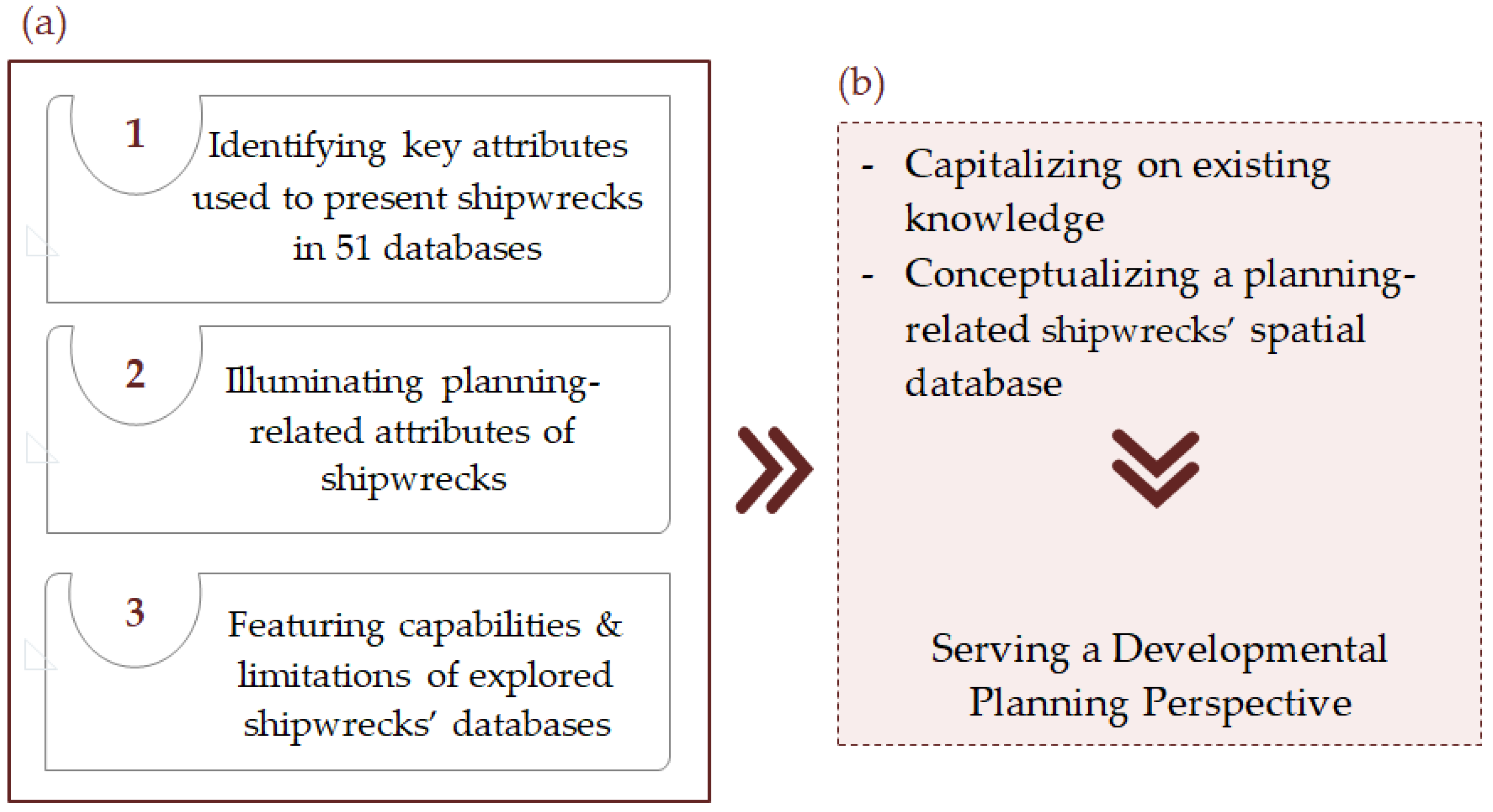
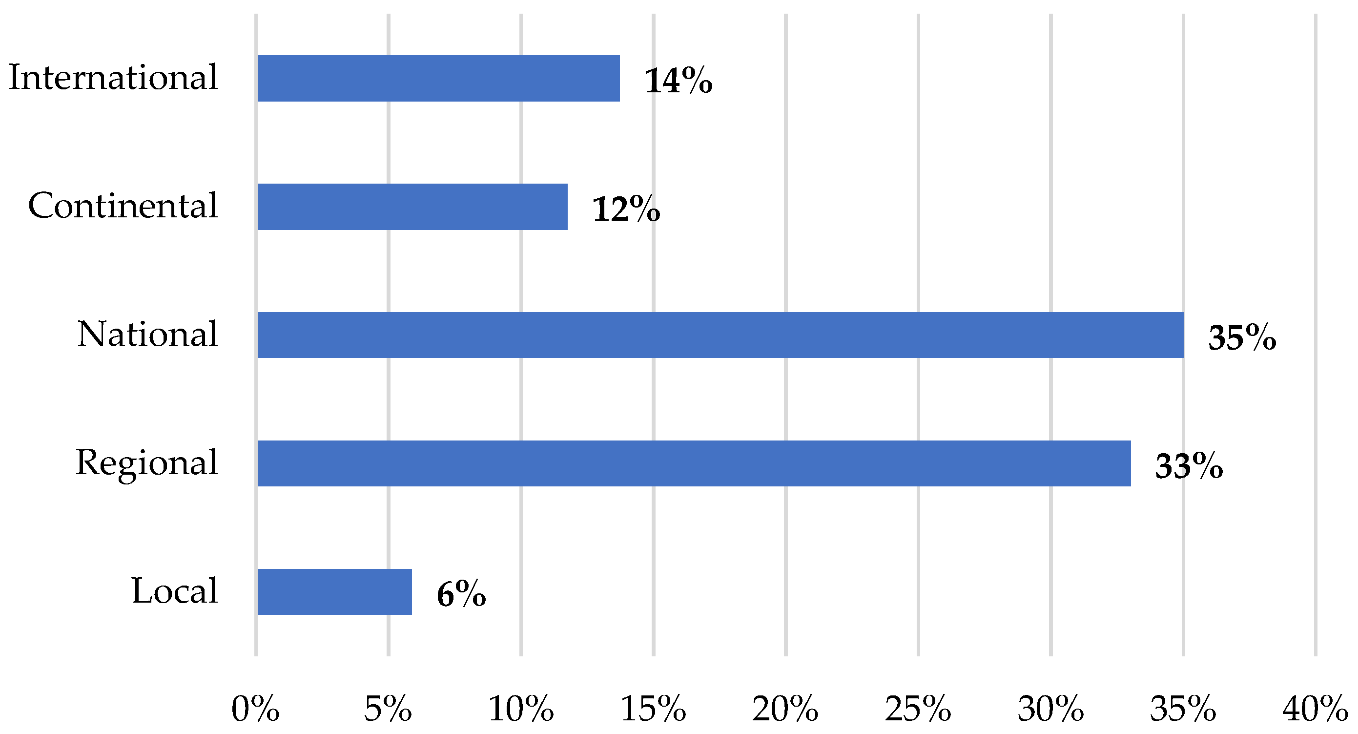
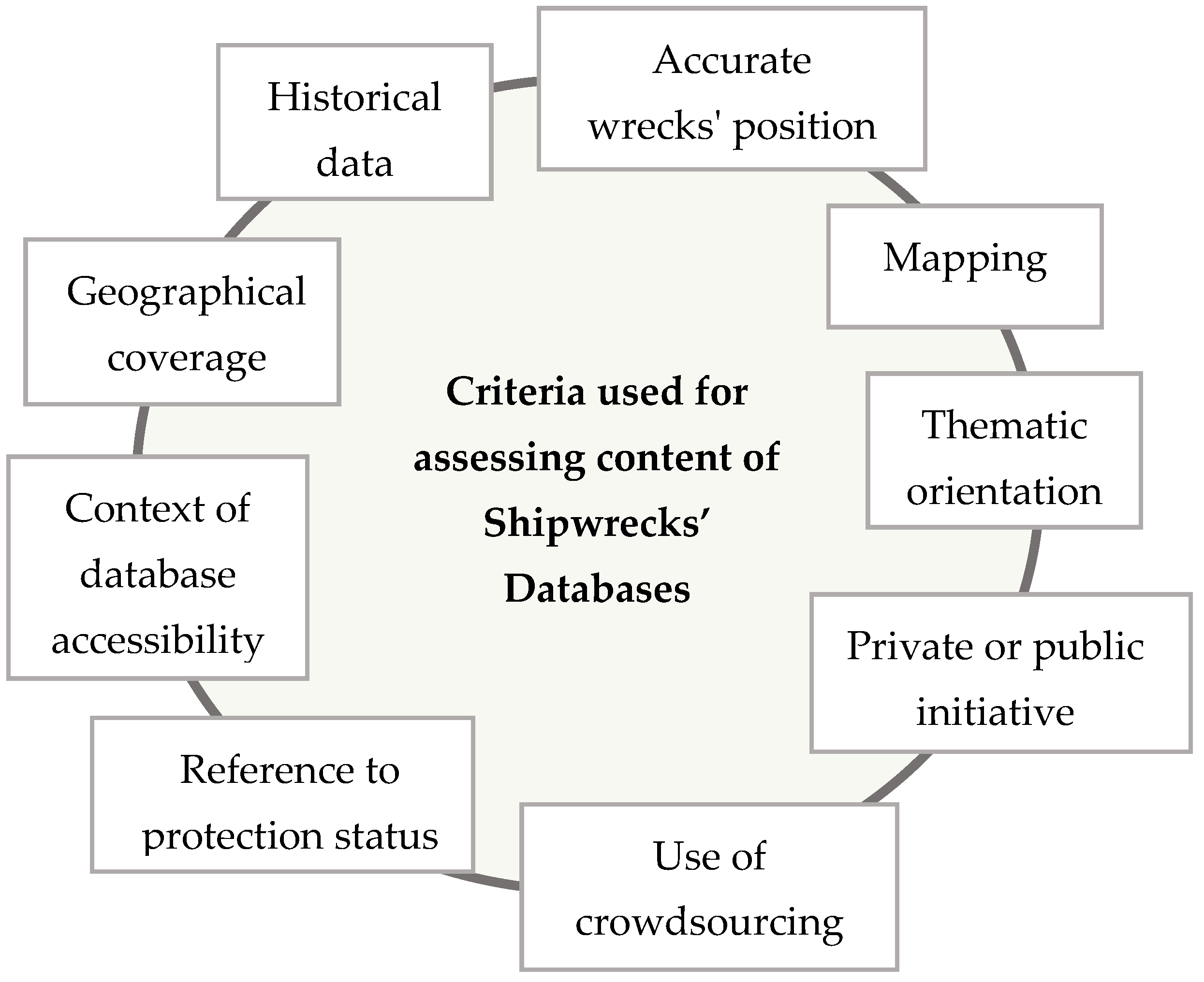
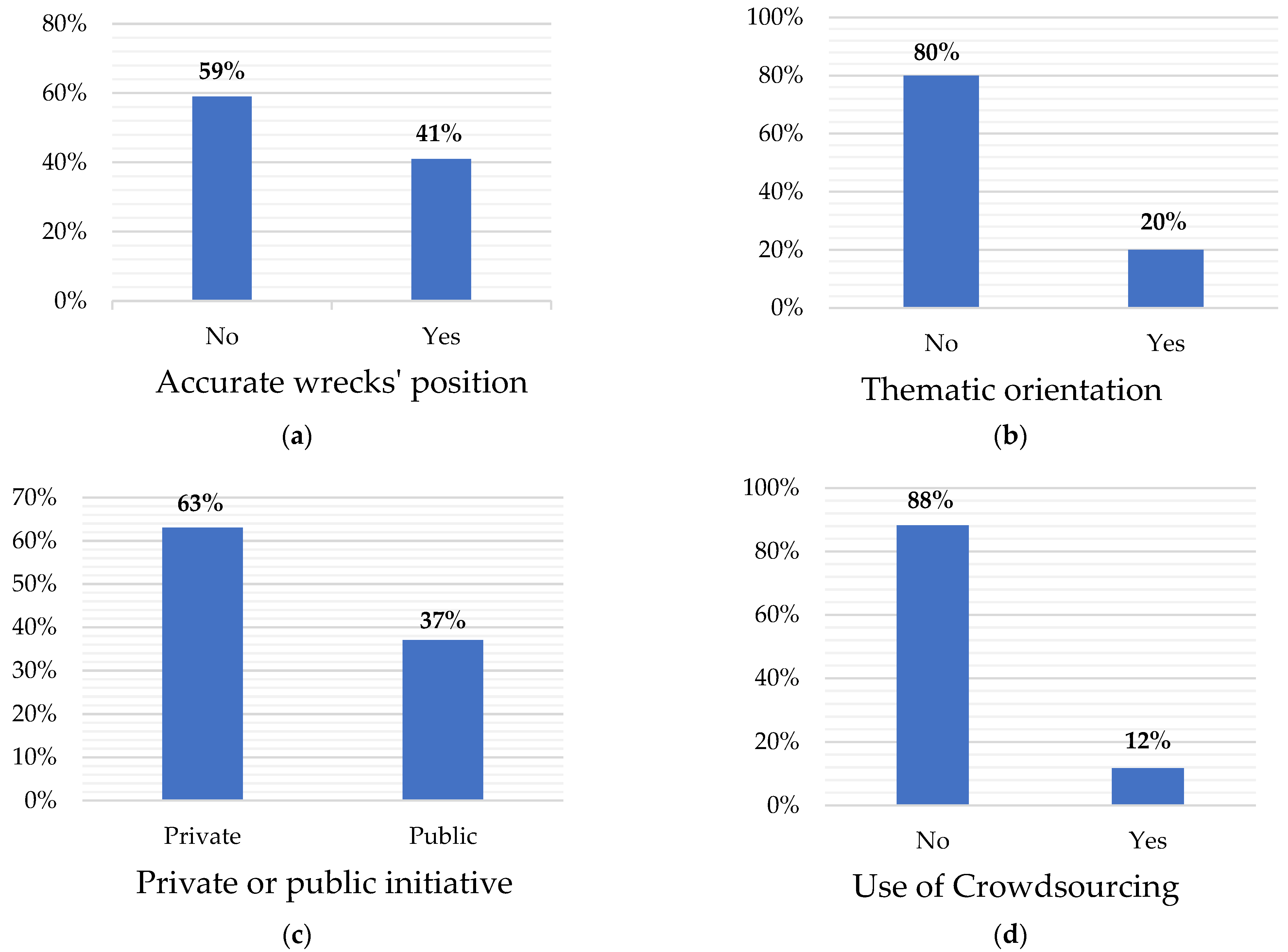
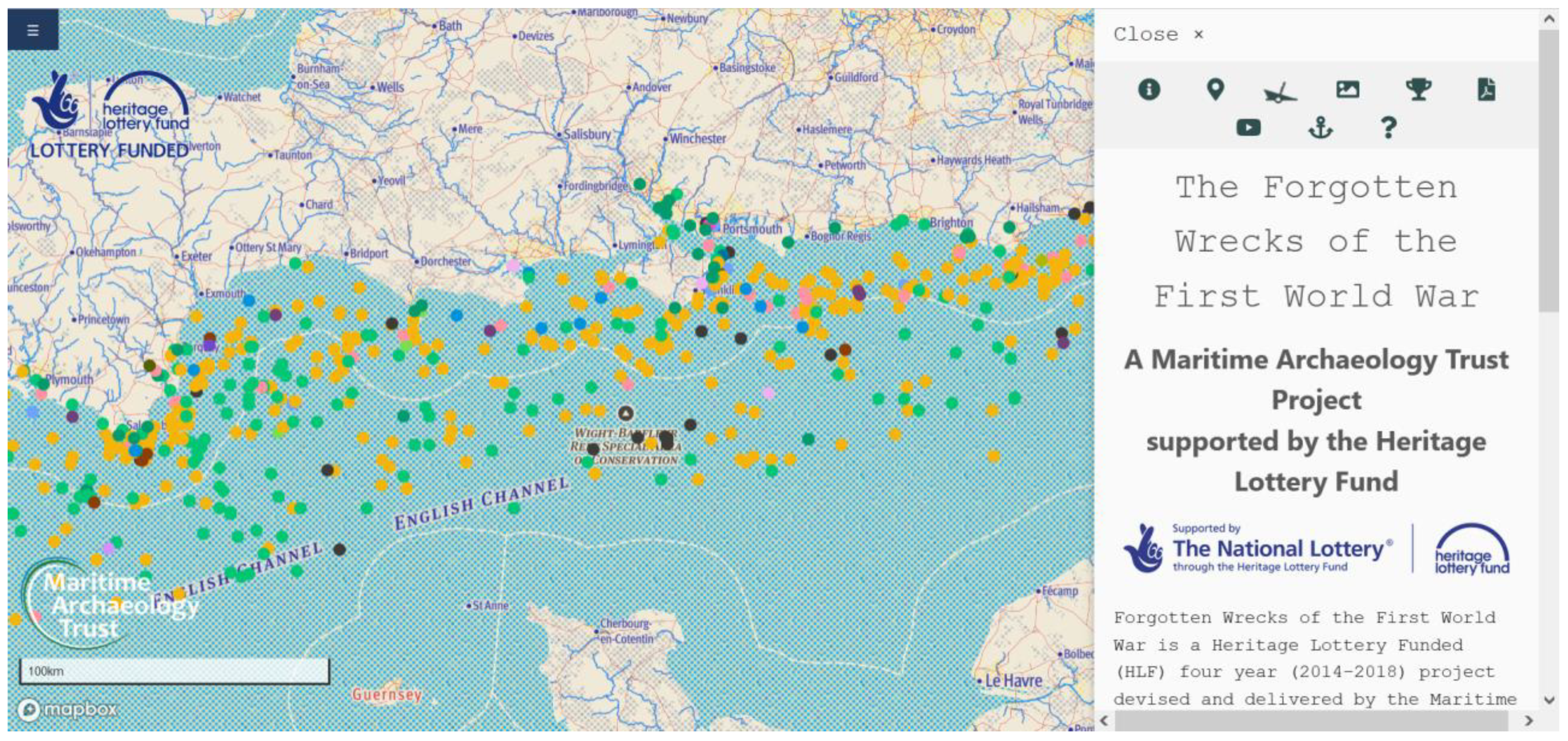
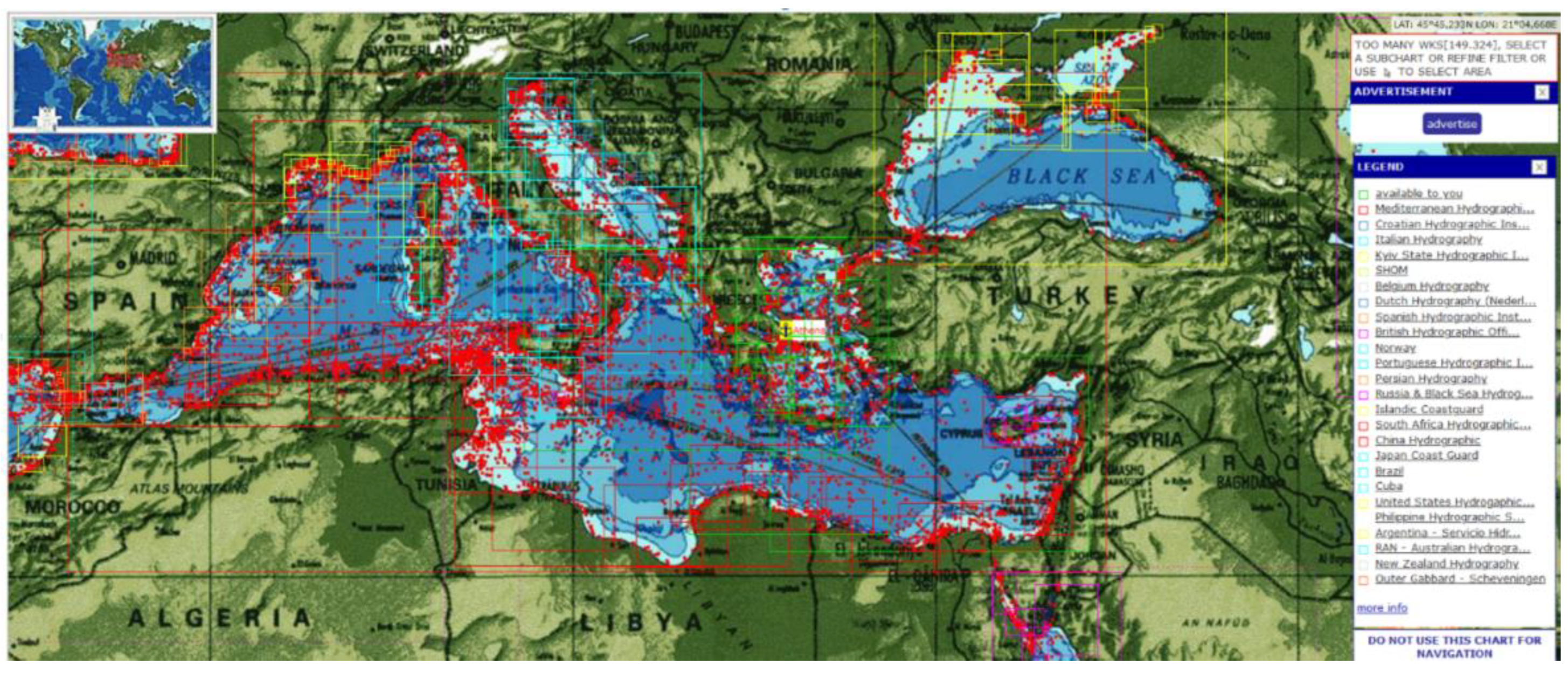
Table 1.
List of the shipwreck databases explored.
| a/a | Database (DB) Name | a/a | Database (DB) Name |
|---|---|---|---|
| 1 | Wreck.eu | 27 | The Oxford Roman Economy Project |
| 2 | NADL | 28 | NOAA |
| 3 | MASS | 29 | MBNMS |
| 4 | Shipintex.org | 30 | Gulf of the Farallones National Marine Sanctuary and Cordell Banks National Marine Sanctuary Shipwreck |
| 5 | UBOAT.net | 31 | Olympic Coast National Marine Sanctuary Shipwreck |
| 6 | Royal Navy wooden shipwrecks DB | 32 | California State Lands Commission |
| 7 | Brasil Mergulho | 33 | Wisconsin Shipwreck DB |
| 8 | Shipwreck Investigations DB | 34 | Minnesota’s Historic Shipwrecks |
| 9 | Nautical Museum of the Atlantic | 35 | Florida’s Underwater Archaeological Preserves |
| 10 | NAVIS II | 36 | Underwater Historic Preserves-Vermont |
| 11 | NAVIS I | 37 | Delaware New Jersey Maritime Museum’s Shipwreck DB |
| 12 | EU Atlas of the Sea | 38 | BOEM |
| 13 | MACHU | 39 | Alaska Shipwrecks |
| 14 | EMODNET | 40 | Australasian Underwater Cultural Heritage DB |
| 15 | Inventories of the DRASSM | 41 | NSW DATABASE |
| 16 | L’Atlas Archéologique des 2 Mers | 42 | Western Australian Museum DB |
| 17 | National Maritime Museum of Norway | 43 | The Red Sea Wreck Project |
| 18 | Irish Wreck DB | 44 | Shipwreck Asia |
| 19 | INFOMAR | 45 | Shipwreck Registry |
| 20 | Wreck Inventory of Ireland DB | 46 | New Jersey maritime museum |
| 21 | Archeomar Project | 47 | Baltic and Nordic wrecks and shipfinds |
| 22 | Archeosub | 48 | Permanent List of Declared Archaeological Sites and Monuments of Greece |
| 23 | Baltacar | 49 | Grafas Diving DB |
| 24 | Britain National Archives | 50 | Samos Scuba Divers Association |
| 25 | UK Diving | 51 | Dive Planet Blue |
| 26 | UK South Coast WWI Shipwrecks |
Source: own elaboration.
Publisher’s Note: MDPI stays neutral with regard to jurisdictional claims in published maps and institutional affiliations. |
© 2021 by the authors. Licensee MDPI, Basel, Switzerland. This article is an open access article distributed under the terms and conditions of the Creative Commons Attribution (CC BY) license (https://creativecommons.org/licenses/by/4.0/).
Share and Cite
MDPI and ACS Style
Koutsi, D.; Stratigea, A. Shipwrecks’ Underwater Mysteries—Identifying Commonalities Out of Globally-Distributed Knowledge. Heritage 2021, 4, 3949-3969. https://0-doi-org.brum.beds.ac.uk/10.3390/heritage4040217
AMA Style
Koutsi D, Stratigea A. Shipwrecks’ Underwater Mysteries—Identifying Commonalities Out of Globally-Distributed Knowledge. Heritage. 2021; 4(4):3949-3969. https://0-doi-org.brum.beds.ac.uk/10.3390/heritage4040217
Chicago/Turabian StyleKoutsi, Dionisia, and Anastasia Stratigea. 2021. "Shipwrecks’ Underwater Mysteries—Identifying Commonalities Out of Globally-Distributed Knowledge" Heritage 4, no. 4: 3949-3969. https://0-doi-org.brum.beds.ac.uk/10.3390/heritage4040217