Article

Impact of Paleoclimatic Changes on the Cultural and Historical Processes at the Turn of the Late Bronze—Early Iron Ages in the Northern Black Sea Region

by
Marianna A. Kulkova
1,*,
Maya T. Kashuba
2,*,
Sergey M. Agulnikov
3,
Alexander M. Kulkov
4,
Mikhail A. Streltsov
1,
Maria N. Vetrova
5 and
Aurel Zanoci
6
1
Department of Geology and Geoecology, Herzen State Pedagogical University, 191186 St. Petersburg, Russia
2
Institute for the History of Material Culture RAS, 191186 St. Petersburg, Russia
3
National Archaeological Agency of the Ministry of Cultureand Research, MD-2000 Chisinau, Moldova
4
RDMI Center, Institute of Earth Sciences, St. Petersburg State University, 199155 St. Petersburg, Russia
5
Institute of Earth Sciences, St. Petersburg State University, 191186 St. Petersburg, Russia
6
Faculty of History and Philosophy, Moldova State University, MD-2000 Chisinau, Moldova
*
Authors to whom correspondence should be addressed.
Submission received: 18 June 2022 / Revised: 14 August 2022 / Accepted: 16 August 2022 / Published: 19 August 2022

Abstract

:
The Late Bronze Age crisis is one of the most significant events in human history an had occurred in about 1200 BCE. The aridization was one the reasons of a decline of agriculture, migrant expansion and the transition to nomadic style of life. In Eastern Mediterranean the collapse of the advanced civilizations such as the Mycenaean, Hittite, Canaanite, Akkadian occurred in this time. The reconstruction of cultural-historical processes at the turn of the Bronze-Early Iron Ages and environment during this “critical” period of 13th–9th centuries BCE in the Northern Black Sea region is important for understanding this event. Interdisciplinary investigations of the paleoclimatic reconstructions and the cultural traditions have been carried out at the key archaeological sites located in the North-Western Pontic region (Saharna Mică, Saharna Mare, Glinjeni II-La Șanț, Dikiy Sad sites and Cazaclia necropolis). For reconstruction of paleoclimatic conditions and anthropogenic activity, the methods of geochemical indication of paleoclimatic conditions and radiocarbon dating were applied. The climatic changes in the Dniester basin towards aridization around 11th–9th century’s calBC were a crisis of the Belozerkа culture in the Pontic steppe and the trigger for the spreading of the Cozia-Saharna cultural communities into the forest-steppe zone and the formation of fortified settlements the Saharna Miča, the Saharna Mare and the Glinjeni II-La Șanț.

1. Introduction

The Late Bronze Age crisis is one of the most significant events in human history and had occurred in about 1200 BCE [1,2,3,4,5,6,7,8,9,10,11]. This collapse was a cause of the cultural transformations, the appearance of new structures of society and a changeover from one lifestyle to another. After the collapse of the Late Bronze Age the transition to the “Dark Ages” had occurred [12,13,14,15,16,17]. The climatic episode of the 3.2 ka calBP (12th–10th centuries BCE) was considered as a W-climatic curve with two phases of aridization which have been broken by the brief episode of increasing humidity about 3000–2950 calBP/1000–950 calBC. In the region of the Mediterranean basin, this episode falls within the framework from ca. 1200 to 950 BCE. The first stage of the culmination of aridization was about ca. 1150 BCE and the second maximum was to ca. 950 BCE [11,18].
The end of the Late Bronze Age in the Carpathian-Danubian basin dates from 15th to 9th/8th centuries BCE. The Late Bronze Age began earlier and extended over the period of the 2nd ka BC on the eastern European part, to the East of the Carpathians. In the steppe zone of Eastern Europe during the humid climatic stage (1500–1200 BCE) the mixed economic style, including mobile pastoralism with agricultural elements, has spread, for example, in the Sabatinovka culture [19,20,21,22,23]. In the period of the Srubnaya (Timber-grave) culture (16th/15th–12th centuries BCE) developed on the Ukraine territory, the climate was humid but at the end of the stage around ca.1100 BCE, it became drier. This is the stage of prolonged arid conditions according to several authors [11,16,24].
During the final Bronze Age stage, the Belozerka culture was developed in the steppe zone of the Northern Black Sea region [25,26,27,28,29,30]. In the burial rituals, there appeared a combination of the burial ceremony and barrow-free burial as in the Cazaclia, Budurzhel, Shirokoe, Brilevka, Pervomaevka, and Kompanytsy burials. The society of the Belozerka culture was very complex and highly stratified with welldefined social distinction. According to S. Agulnikov [30], during its final stage, the Belozerka culture was under pressure from the Early Hallstattian culture. The development of black polished pottery with flutes is a marker of the Hallstattian cultural influence on the Belozerka culture. The bearers of the Noua-Sabatinovka culture occupied the steppe zone of the south-western part of the Northern Black Sea region. At the turn of 13th–12th centuries BCE the Belozerka culture had been formed in this area, in the burial ceremony of which the components of three previous cultures such as the Sabatinovka, Srubnaya and Noua were established. The main cultures and their chronology are presented in the Figure 1.
In the forest-steppe zone between the rivers of Dniester and Don because of migrations, new cultures with complex economic types like the Chernoless culture have been formed [31].The beginning of the final stage of the Late Bronze and the transition to the Early Iron Age (end of 13th–10th centuries BCE) coincided with the disintegration of the Srubnaya and Andronovo cultural-historical societies. The analysis of artifacts and cultural layers at the main archaeological sites of the Northern Black Sea region is crucial for detail reconstructions of cultural-historical processes and the environment during this “critical” period of 13th–9th centuries BCE. Interdisciplinary investigations for the paleoclimatic reconstructions and the different cultural traditions have been carried out at the archaeological sites in the Prut-Dniester basin and the southern part of the Danube and Dniester interfluves (Saharna Mică, Saharna Mare, Glinjeni II-La Șanț sites, and Cazaclia necropolis) as well as in the central part of the South Bug basin (Dikiy Sad site) (Figure 2). These archaeological sites are the key monuments for an understanding of the changes, which had a place at the turn of the Bronze-Early Iron Ages in the Northern Pontic region [32,33,34,35]. The aim of this research is the reconstruction of paleoclimate during the Bronze to Iron transition on these reference archaeological sites and comparison of the data. This is the first investigations in this region that is considering the cultural and historical transformations with connection of climatic events and finds out the consequences of such changes.
The Dniester Basin is approximately 700 km long, with an average width of about 100 km and a slope of 56 cm/km [36]. It is bordered by the Carpathian Mountains of the west. In the north-west, north, south-east and west, the basin is bounded by the water divisions Sano-Dniester, Rostochia, Dniester-Bug, Dniester-Prut and Dniester-Black Sea. The lower Dniester basin is located in the Black Sea lowlands, which are steppe plains. The topography of the lower part of the watershed is that of a gently sloping plain. This encourages the development of a vast wetland in the floodplain of the river, dissected by branches, old river beds that are often flooded [37]. The climate of the upper and middle Dniester was largely shaped by the local topography, with the mountains of the Carpathians and Volyn Upland. It plays an important role in terms of air flow, mountain-induced front genesis and air mass transformation over plain areas. The climate of the Basin’s mountainous part is characterized by lower temperatures and higher humidity. The southern zones of the basin are within the Black Sea climate subarea, which is part of the continental Atlantic/Steppe climate region. Winters are usually mild and have little chance of thawing. In spring, moderately continental air masses gradually change to tropical masses, and warm, sunny weather sets in in May. The annual air humidity model is entirely synchronized with the temperature model, with maximum humidity levels/temperatures recorded in July, and the respective minimums in January. Annual precipitation also varies greatly throughout the basin, ranging from 1200 mm or more in the Carpathians to 500 mm in the lower Dniester basin [38,39,40].

2. Materials and Methods

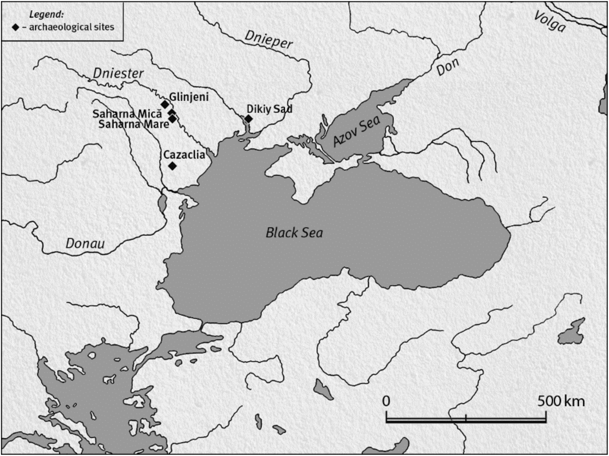
2.1. Materials—Characterization of Site and Sampling Strategy

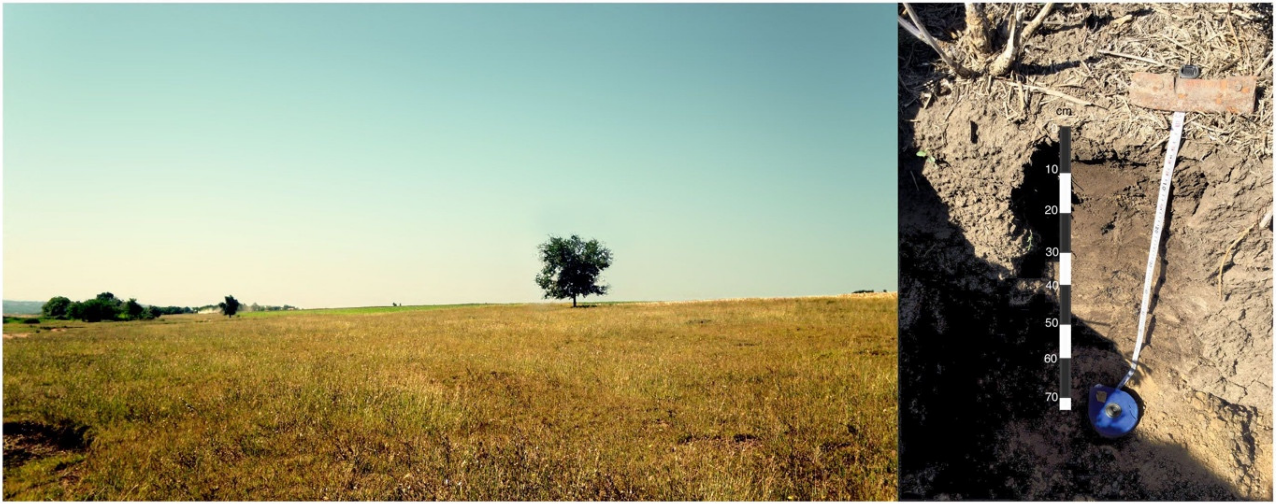
2.1.1. The Dikiy Sad Site

One of the unique sites of the Belozerka culture is the Dikiy Sad settlement. At the present time, there are ruins of the port “city” of the 12th–9th centuries BCE in the Mykolaiv city (46.59′08″ N; 31.59′44″ E) in the south of the steppe zone of Ukraine (Figure 2 and Figure 3). The settlement is situated on a high shore cape in the interfluvial of South Bug and Ingul Rivers. This settlement was the northern point of the Black Sea waterway and, at the same time, it was located on the intersection of several land transport ruts [41,42,43]. The square of the settlement is 3 ha. Dr. K.V. Gorbenko has been conducting the excavations since 1998 [42]. The Dikiy Sad settlement structure comprises a fortified «citadel», fenced by a ditch, “suburbs”, fenced by an external ditch, and «posad», located behind an external ditch. The cultural layer on the exterior of the premises has been almost destroyed recently. Remnants from the Bronze Age cultures were found in these layers. The most complete stratigraphy of the cultural layers conserved in an intact state within the remains of constructions. The upper layers are the sod-forming horizon (0–10 cm). Under these deposits there is a stratum of light-grey loess (10–45 cm). Artifacts of the Belozerka culture were found in the loess of light-grey color on a depth of 10–45 cm. At the base of this cross-section, there is a sandy-loamy loess with carbonate inclusions at a depth of 45–60 cm [44].

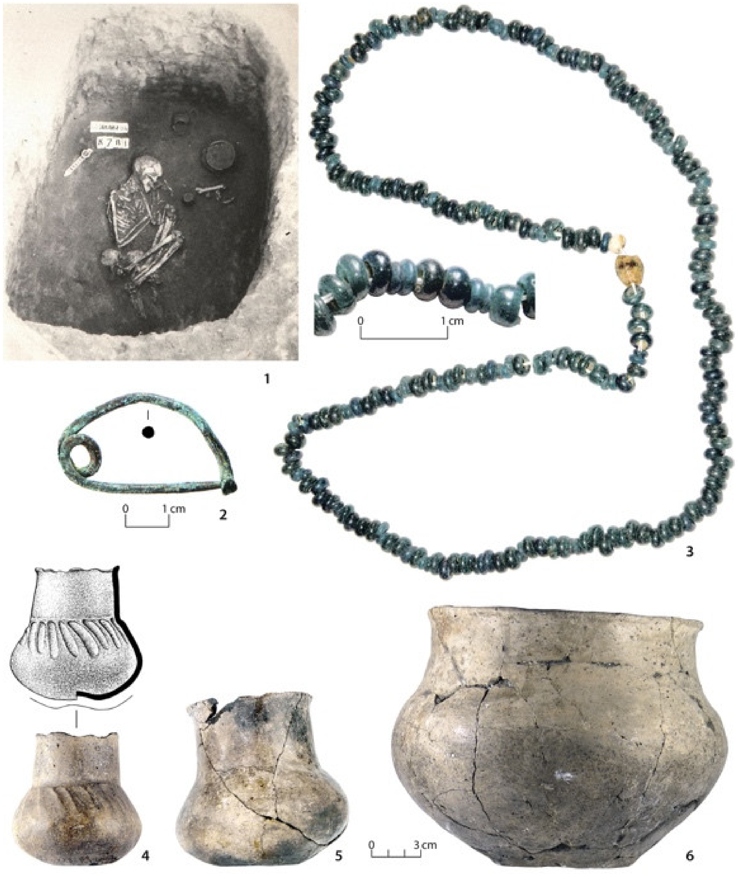
2.1.2. The Cazaclia Necropolis (Belozerka Culture)

One of the large necropolises in the Danubian-Dniester region is the Cazaclia necropolis (45.57′50″ N; 28.37′21″ E), located in the Budzhak steppe in the South of Moldova, in the basin of the Yalpug River [29,45] (Figure 2, Figure 4 and Figure 5). The topography of necropolises of the Belozerka culture is connected with their location on the plateau and watersheds of steppe rivers and estuaries of the Black Sea. The burials belong to 12th–10th centuries BCE. As a rule, they were constructed near one or several mounds of more ancient cultures. The orientation along lines of latitude is a feature of the Belozerka necropolis compared to mounds of other cultures located along meridians. The rows of soil burial grounds have a latitude orientation and were near mound embankments of the same culture. Originally, the large mound embankment was built above the rich burial with the large gravesite camera contained an unusual inventory. After that, several soil burial grounds have been constructed linearly in latitude orientation with the main mound. In the Cazaclia necropolis, there was just one main burial in the main mound No. 7 [29]. There were excavated several soil burial grounds of the Belozerka culture. At the place of the necropolis, the stratigraphy of cultural deposits in three pits has been explored. At the depth of 0–25 cm, there is a sod-soil horizon; beneath at the depth of 25–75 cm the humus loam of dark brown color with artefacts of the Belozerka culture are located. At the bottom of pits the loam of light yellow color lies down.

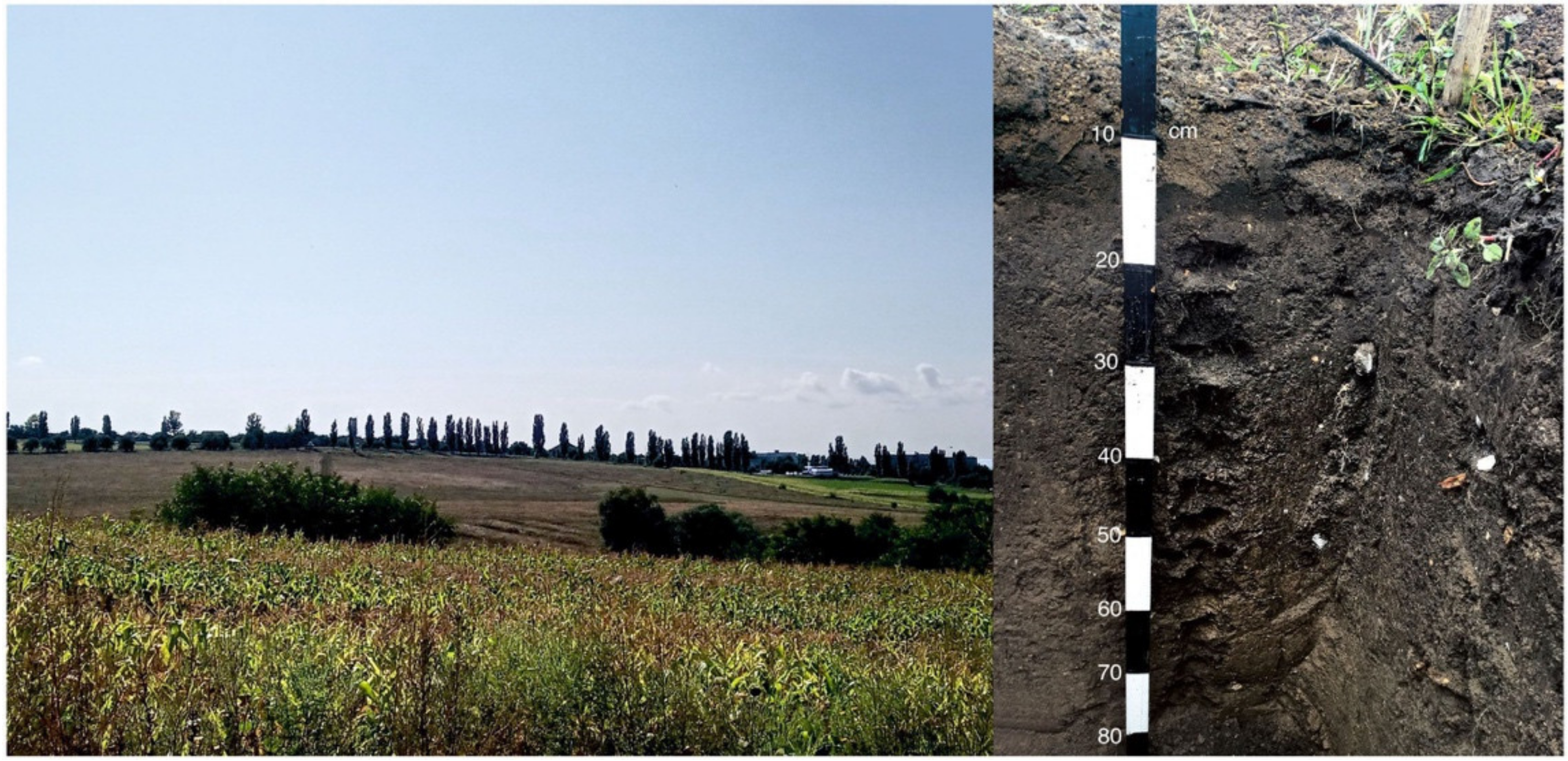
2.1.3. The Saharna Micro-Zone Late Bronze—Early Iron Age Sites

Close to the village of Saharna (Rezina district, Republic of Moldova) there is the special micro-zone due to the diversity of relief shapes, geology or variety of soil types. This micro-region became the special site of the numerous infiltrations and the interaction of the prehistoric societies during the Late Bronze and Early Iron Ages (Figure 2, Figure 6 and Figure 7). The sequence of cultural-historical sites and interactions in this micro-zone was determined as follows: three open settlements and some graves in the Saharna I (Ţiglău) necropolis were attributed to the Holercani-Hansca cultural group (12th–11th centuries BC); three fortifications, ten open settlements and two necropolises belong to the Cozia-Saharna culture (end of the 11th century BC to the beginning of the 8th century BC); three settlements are dated to the Basarabi-Şoldăneşti culture (8th–7th centuries BC); the communities of the Getic culture existed from the end of the 7th century BC to 3rd century BC, 16 fortifications and about 14 open settlements attested here ([46]: 23 ff., Figure 1 and Figure 2; Table 1 with later literature).
Figure 6. The Saharna Mică fortified settlement. View at the “Crac Valley” gorge (1); basic types of smoothed vessels (4,7) and polish vessels (2,3,5,6,8), selectively, according to [47,48], designed by A. Zanoci and M. Kashuba.
Heritage 05 00118 g006

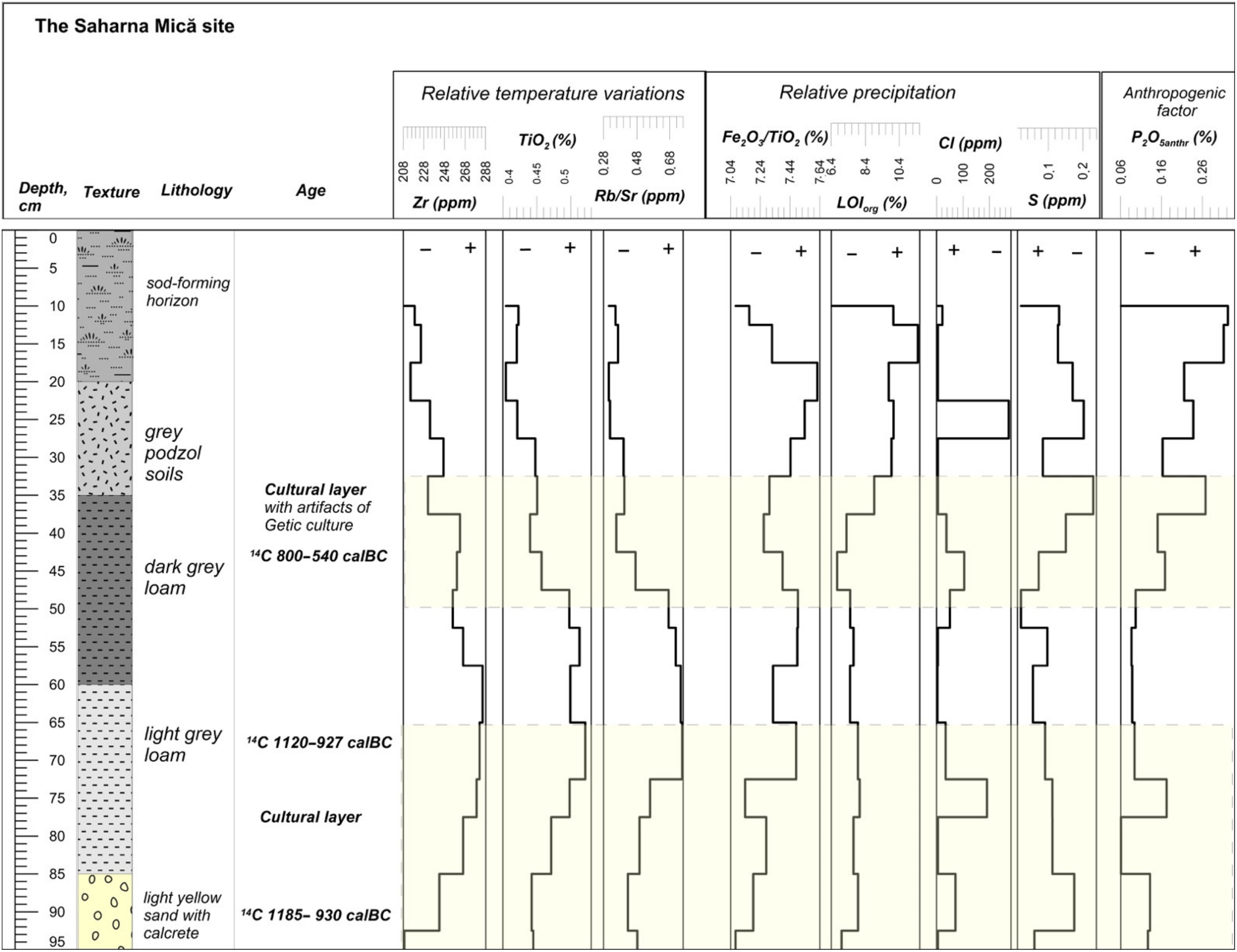
2.1.4. The Saharna Mică Site

The Saharna Mică site is situated on the high shore of the Dniester River, on the hill near to the reinforced hillfort Saharna Mare [47,48] (47.41′50″ N; 28.57′23″ E) (Figure 2, Figure 6 and Figure 7). At the depth of 0–20 cm from the surface, there is the layer of sod-forming horizon. Beneath at the level of 20–30 cm there is the podzol of grey color. Under these deposits at the depth of 35–60 cm the cultural layer with the artifacts of the 6th–5th centuries BCE is presented by dark-grey loam with high humus content. The second cultural horizon of light-grey loam lies at the depth of 60–85 cm. In this layer, the artifacts of the Holercani-Hansca cultural group (12th–11th centuries BC) and the Cozia-Saharna culture (10th–9th centuries BC) were found. At the bottom of 95–105 cm, there is the light yellow loam with calcrete and iron nodules.

2.1.5. The Saharna Mare/“Dealul Mănăstirii” Site

This site is located in the west of the Saharna village on a hill with an area of about 15 ha and an altitude of about 130 m upper of the Dniester River level (47.41′33″ N; 28.57′26″ E). Around the cape, two ravines, with steep slopes are situated that is formed a valley called by the locals “Valea Crac” [47,48,49]. In this region, brown and gray forest soils and chernozem podzolic soils are developed.
According to Zanoci et al. [49] on the Saharna Mare cape there are excavated several open and fortified settlements dated between the second half of the 12th century and the end of the 3rd century BC (Figure 2, Figure 8 and Figure 9). An open settlement attributed to the Holercani-Hansca cultural group dated from the second half of the 12th century to the 11th century BC was discovered. Around 10th–9th centuries BC there was a hillfort and a large open settlement that belonged to the Cozia-Saharna culture. A settlement of the Basarabi-Şoldăneşti culture existed in the next period of the 8th–7th centuries BC. In the 6th–3rd centuries BC on the Saharna Mare cape there was a fortification attributed to the Thracian-Getic communities. Pottery is the most numerous category of artifacts found in the fortification and the open settlement of Saharna Mare/“Dealul Mănăstirii”. For the early Iron Age at Saharna Mare it is possible to determine the following types of vessels: two-handled vessels, pots, bowls, cups, and pyxides [49]. The earliest iron knives of the 11th century BC were found on the Saharna site. The deposits for analysis were sampled from the cross-section in the excavation 31, pit 2 (Figure 9). The upper part of the deposits (0–45 cm) is presented by the podzol soils. On the depth of 45–70 cm the artifacts of 3rd–2nd centuries BCE were found in the dark grey humus loam. At the depth of 70–98 cm the cultural layer with archaeological finds of 11th–3rd centuries BCE has been identified. Beneath there is yellow clay.

2.1.6. The Glinjeni II-La Șanț Site

The Glinjeni II-La Șanț fortified settlement is located in the Rezina district, Republic of Moldova (47.48′54″ N; 28.52′29″ E) in the river basin of the Dniester, in the southwestern periphery of the modern village Glinjeni, Republic of Moldova. The site description was mentioned elsewhere [50]. The site is located at an elevation of 184 m above sea level. It was based on the upper terrace of the left bank of the deep and narrow river plain of the Chorna, a right tributary of the Dniester Estuary and stretches over a length of 42 km, an approximately west-east location (Figure 2, Figure 10 and Figure 11). The Glinjeni II-La Șanț is a multilayer fortified settlement (Late Paleolithic to Early Medieval, with interruption) without traceable vertical stratigraphy [51]. All finds from different stages were established in the main cultural layer with a thickness from 0.6 to 1.2 m. A horizontal stratigraphy with features (dwellings, pits, ditches) of different chronology was applied. Some structures were attributed to so-called mixed complexes, which existed a long time and were rebuilt several times. The group of so-called mixed ceramics with elements of both cultural traditions such as the earlier Cozia-Saharna and the later Basarabi-Șoldănești dated from the 10th–beginning of 7th centuries BC [51] were discovered in the process of excavations. The investigations of pottery from this site were published elsewhere [50]. The stratigraphy of the cultural layers at the sites is presented by the podzol horizon (0–20 cm); 20–40 cm is humus horizon; 40–80 cm is light grey sandy loam with artifacts of Cozia-Saharna and the later Basarabi-Șoldănești cultures (Figure 11).
The sediments from the cross-sections at the sites were taken through each two/five centimeters of stratigraphic successions for analysis of the geochemical and mineralogical compositions. The deposits of cultural layers were sampled for radiocarbon dating.
Figure 10. The Glinjeni II-La Șanț fortified settlement. Basic types of polish high-quality vessels (1,2—large pots with high neck; 3,4—cups; 5—bowl), selectively, according to [51], designed by M. Kashuba.
Heritage 05 00118 g010
Figure 11. The Glinjeni II-La Șanț cross-section.
Heritage 05 00118 g011

2.2. Methods

For reconstruction of paleoclimatic conditions and anthropogenic activity, the method of geochemical indication of environmental-paleoclimatic conditions was applied [52,53,54,55]. An important criterion is the assessment of anthropogenic activity by the geochemical method in the layers of the stratigraphic sequence at the sites. Such an approach allows us to synchronize the changes of anthropogenic activity in lithological layers with climatic events occurring in a given time period. The method of geochemical indication of environmental and climatic conditions [53] is the most all-purpose method based on the mineralogical and geochemical characteristics of various genesis sediments. On this base the factors of environmental and climatic changes such as a relative temperature, a relative precipitation, and water level variations in the basin can be determined. Loose sedimentary deposits were sampled at the archaeological sites, along cross-sections with a clear lithological sequence, every 2–5 cm. For geochemical analysis, after each crushing cycle, control sieving was carried out, and the residue is crushed to the desired grain size [56]. Then all crushed material is combined. Manual reduction is carried out by the method of multiple (no more than 3 with one crushing) quartering and combining the material of two opposite quadrants to continue processing according to the accepted scheme. Due to the heterogeneity of the distribution of components in large and small fractions, before reducing the samples, they are mixed and then quartered.
The sample is ground to a powder to a particle size of 200 meshes, 0.074 mm (to the state of powder). For X-ray spectral Fluorescence analysis using the Spectroscan Max-WD spectrometer, 300 mg samples were pressed into a tablet using a boric acid substrate.
The geochemical indicators and modules were used to reconstruct the features of the formation of sedimentary deposits. The relative temperature changes for terrigenous sediments can be characterized by the distribution of the titanium module (TiO2/Al2O3) and the change in the content of zirconium (Zr) in the sedimentary stratum [57]. The titanium module, in this case, shows the accumulation of accessory, weathering-resistant minerals of the titanium group in the psammitic fraction, and alumina in the pellitic fraction, which is formed in result of more intense chemical weathering in a warm and humid climate. Changes in the temperature balance were also determined based on the modules Na2O/K2O, Sr/Rb, which reflect the transformation of plagioclase/feldspar, mica, clay minerals depending on weathering processes, mainly temperature effects.
The destruction of potassium feldspar, according to the authors [54,55], is slower than that of plagioclases and leads to the accumulation of potassium (K2O) as a component of mica and clay minerals resistant to subsequent weathering.
The Nesbitt and Young Index (CIA) shows the degree of transformation of aluminosilicate minerals and changes in the mineral composition in result of chemical weathering, depending on the relative humidity of the climate (CIA = Al2O3/(Al2O3 + CaO + Na2O + K2O) × 100%) [58]. The CaO/MgO (Ca/Mg) ratio shows the increase in calcium relative to magnesium in the carbonate component under arid conditions, and has also been used to analyze changes in humidity and temperature balances under arid conditions.
The marker P2O5antr = P2O5/(P2O5 + Na2O) was used to assess the anthropogenic impact [53,59]. Elevated values of this indicator correlate well with the horizons of cultural deposits contained in the traces of ancient people activity and the artifacts. In this case, the ratio can be established and separated phosphorus of anthropogenic origin from calcium and phosphorus of lithogenic origin, which are associated with the lithological component of the deposits.
The radiocarbon dating of cultural deposits was conducted using the standard method on humic acids from soils. The radiocarbon dating of humic acids was performed through the radiometric liquid scintillation technique in the Isotopic Lab of Herzen State University (St. Petersburg) [60,61]. The results of radiocarbon dating are presented in Table 1. The soil samples were pretreated by the standard method using hydrochloric acid (3% HCl) for ancient carbonate removal. After that, humiс acids were extracted by alkali (1% NaOH) [62]. The lithium carbide was obtained in the process of carbidization at T = 750 °C in an oven in a vacuum atmosphere. The counting liquid is benzene obtained in the process of polymerization of acetylene on chromium catalysis. Acetylene was produced as a result of lithium carbide decomposition of water [63]. The radiocarbon activity was measured with the help of low background scintillation counter Quantulus 1220. The application of scintillations (POPOP and PPO) needs to add in benzene [64]. The date calibrations (Figure 12) were carried out with help of the program OxCal 4.4. [65].
Table 1. Radiocarbon dates on humid acid of soils from archaeological sites of the Prut-Dniester basin and the southern part of the Danube and Dniester interfluves.
No.Archaeological SiteLab Index14C Age BPCalibrated Date
(2σ) calBC
1No. 1 Saharna Mare, cross-section 2 (excavation 31), pit 2SPb-31922435 ± 35751–406
2No. 3 Glinjeni II-La Șanț, 2019 (60–50 cm)SPb-31942810 ± 301050–849
3No. 4 Saharna Mică (40–50 cm)SPb-31952528 ± 40798–540
4No. 5 Saharna Mică (95–90 cm)SPb-31962867 ± 301185–927
5No. 6 Cazaclia necropolis, cross-section 3 (40–35 cm)SPb-31972833 ± 301108–906
6No. 7 Saharna Mică, cross-section 1 (70–60 cm)SPb-31982860 ± 301122–927

3. Results

The interpretation of geochemical data of sedimentary strata for each archaeological site is considered in separate sections of this chapter. The variations of geochemical indicators are presented in Figure 13, Figure 14, Figure 15, Figure 16 and Figure 17.

3.1. The Dikiy Sad Site

The Dikiy Sad site is located in the shore zone of the Black Sea and has been influenced by temperate marine climate. The relative temperature changes were established on the base of geochemical indicators (Zr, Na2O/K2O) in loess in the cross-section on the site (Figure 13). The relative precipitation was determined with help of the CIA module. The anthropogenic activity was characterized by means of P2O5antr variations compared to background concentrations in these deposits. It is worth noting the sedimentation on this site was in the period of humid climatic conditions for this area: CIA (70–76%). In the bottom part of the cross-section (56–54 cm) the loess formation was in the conditions of humid and warm climate: CIA (76%), Na2O/K2O (0.71%), Zr (40–42 ppm).The anthropogenic activity is low: P2O5antr (0.16%). At a depth of 54–44 cm, there is light yellow loess with inclusions of calcrete. These deposits were sedimented during more dry and cold conditions: CIA (70–72%), Na2O/K2O (0.84%), Zr (38–27 ppm). The climatic changes to the humid and warm conditions are registered in the layer of sandy loess deposits at a depth of 43–33 cm: CIA (73–75%), Na2O/K2O (0.52–0.75%), Zr (30–38 ppm). The anthropogenic activity in this period increased: P2O5antr (0.45%) in comparison to the background level of P2O5antr in loess (0.18%). These deposits are the cultural layer containing artifacts of the 13th/12th–11th centuries BCE. In deposits on a depth of 26–24 cm the next stage of climatic changes was recorded. According to the climatic indicators the climate became more dry (CIA 70–71%) and cold (Na2O/K2O 0.85–0.92%, Zr 31–42 ppm). The anthropogenic activity is low: P2O5antr (0.25%). The maximum of aridization was recorded in the deposits at the depth of 20–16 cm: CIA (70%), Na2O/K2O (0.92%), Zr (30–32 ppm). The high anthropogenic activity is a characteristic of this layer: P2O5antr (0.76%). This layer is the cultural deposits of the 11th–10th centuries BCE. The sedimentation at the depth of 16–10 cm was in the warm and humid conditions: CIA (74–76%), Na2O/K2O (0.32–0.52%), Zr (27–35 ppm). The anthropogenic activity decreased: P2O5antr (0.22–0.25%). In the layer of this depth, the artefacts have not been found.
Figure 13. The schemes of paleoclimatic changes on the base of the geochemical indicators for cross-section of the Dikyi Sad settlement.
Heritage 05 00118 g013

3.2. The Cazaclia Necropolis

The Cazaclia necropolis is located in the steppe zone of the Danube-Dniester basin in the lowland. The relative temperature variations were determined based on the geochemical markers (Zr, TiO2/Al2O3, Rb/Sr, Na2O/K2O) (Figure 14). The changes in relative humidity were determined with help of modules (CIA, CaO/MgO, Fe2O3/MnO, S). The anthropogenic activity was characterized through P2O5antr variations compared to background concentrations in the same type of deposits. Features of stratum formation at this site register the transition from dry to humid climatic conditions for the steppe zone: CIA changed from 42 to 60%. In the cross-section at the depth of 80–74 cm, the light-yellow loam was deposited. The formation of this layer was during dry, cold conditions: CIA (42–43%), Na2O/K2O (1.5–2.5%), and Zr (356 ppm). The anthropogenic activity is low: P2O5antr (0.023%). At a depth of 75–52 cm, there is the brown humus loam. The loam formation was in the relatively humid and moderately warm climatic conditions of the steppe zone: CIA (55–60%), Na2O/K2O (1.5–2.5%), Zr (356–382 ppm). In the bottom part of deposits at a depth of 75–66 cm, the anthropogenic activity increases (P2O5antr (0.038%)), compared to the background level (0.020–0.023%). At a depth of 52–28 cm, there are the deposits of the cultural layer with remains of burials of the Belozerka culture. This layer sedimented during humid and warm conditions: CIA (57–62%), Na2O/K2O (2.0–2.2%), Zr (376–398 ppm). The anthropogenic activity increases in deposits of this layer: P2O5antr (0.030–0.042%). The radiocarbon age of soils from the depth of 40–35 cm is 1108–900 сalBC (2σ) (Table 1).
Figure 14. The schemes of paleoclimatic changes on the base of the geochemical indicators for cross-section of the Cazaclia necropolis.
Heritage 05 00118 g014

3.3. The Saharna Mică Site

The Saharna Mică site is situated in the forest-steppe zone on the hilly bank of the Dniester river. The sediments at the site are presented by soils and humus loams. The anthropogenic activity at the site was determined by the P2O5antr in the deposits compared to the background level for this type of sediment. The relative temperature changes were determined using geochemical indicators (Zr, TiO2, Rb/Sr) (Figure 15). Changes in the relative humidity are characterized by the markers (Fe2O3/TiO2, Cl, S, LOIorg). The light yellow sand with carbonate inclusions occurs at the depth of 100–85 cm. The deposits were formed in a moderately humid and cool climate: LOI (6.4–8.4%), Fe2O3/TiO2 (7.24–7.3%), Zr (268–208 ppm), Rb/Sr (0.28–0.48 ppm). The anthropogenic activity: P2O5antr (0.20–0.25%), the background level for these deposits (0.05%). For the cultural layer at a depth of 95–90 cm, the 14C date of 1190–930 calBC (2σ) (Table 1) was obtained from the humus extract of the soil. Deposits at a depth of 85–65 cm are dark grey humus clayey sand. The deposits were formed in a warm and humid climate: LOI (8.2–8.4%), Fe2O3/TiO2 (7.16–7.24%), Zr (268–288 ppm), Rb/Sr (0.30–0.68 ppm). The anthropogenic activity increased: P2O5antr (0.26–0.16%). The cultural deposits at a depth of 70–60 cm have the date on humus of 1122–927 calBC (2σ) (Table 1). At a depth of 65–55 cm, sedimentation changes, and deposits of clayey sand are changed into grey humus sand. The climatic conditions for this period can be characterized as very warm and dry: LOI (7.5–8.0%), Fe2O3/TiO2 (7.24–7.35%), Zr (260–288 ppm), Rb/Sr (0.68–0.70 ppm). The anthropogenic activity is low: P2O5antr (0.1–0.12%). Changes in the climatic conditions are recorded in deposits of grey humus sand, at a depth of 50–32 cm. In the lower part of the deposits, at a depth of 50–45 cm, according to geochemical indicators, warm and humid conditions are recorded: LOI (7.0–8.3%), Fe2O3/TiO2 (7.44–7.64%), Zr (268–288 ppm), Rb/Sr (0.48–0.68 ppm). The anthropogenic activity increases P2O5antr (0.16–0.18%). For deposits at a depth of 40–50 cm, the radiocarbon date obtained from a humus extraction is ca. 800–540 calBC (2σ) (Table 1). The deposits (45–35 cm) were formed in a more humid and cooler climate: LOI (8.4–9.0%), Fe2O3/TiO2 (7.3–7.32%), Zr (228 ppm), Rb/Sr (0.3–0.33 ppm). The anthropogenic activity is high: P2O5antr (0.16–0.28%). Artifacts of the Getic culture were found in these deposits. At a depth of 35–20 cm, deposits of a grey podzolic horizon are developed. In the sediments, high anthropogenic activity is recorded according to geochemical data: P2O5antr (0.16–0.24%). The deposits were formed in cooler and humid climatic conditions: LOI (9.0–10.4%), Fe2O3/TiO2 (7.44–7.64%), Zr (252–220 ppm), Rb/Sr (0.3–0.45 ppm).
Figure 15. The schemes of paleoclimatic changes on the base of the geochemical indicators for cross-section of the Saharna Mică site.
Heritage 05 00118 g015

3.4. The Saharna Mare/“Dealul Mănăstirii” Site

The Saharna Mare settlement is located close to the Saharna Mică site in the forest-steppe zone, on a hill. The lower part of the deposits of the cross-section is presented by light yellow loam, a depth of 95–92 cm (Rb/Sr 0.64–0.7 ppm) (Figure 16). The light grey loam occurs at a depth of 92–70 cm. The deposits were formed during a period of warm and rather humid conditions: LOI (8.2–9.2%), Fe2O3/TiO2 (6.8–7.2%), Zr (172–152 ppm), Rb/Sr (0.54–0.52 ppm). The anthropogenic activity increases P2O5antr (0.18–0.26%). In deposits at a depth of 85–60 cm, artifacts of the Holercani-Hansca cultural group and the early phase of the Cozia-Saharna culture of the 12th–11th centuries BCE were found. The light grey loam occurs at a depth of 70–45 cm. Deposits at a depth of 70–57 cm were formed in a humid and cool climate: LOI (7.2–7.5%), Fe2O3/TiO2 (7.0–7.2%), Zr (112–132 ppm), Rb /Sr (0.44–0.46 ppm). The anthropogenic activity is high: P2O5antr (0.24–0.26%). Deposits at this depth are dated by means of the radiocarbon dating on humic acids about ca. 750–400 calBC(2σ) (Table 1). At a depth of 57–45 cm, the sediments were formed in the conditions of warmer and more humid climate: LOI (7.2–8.5%), Fe2O3/TiO2 (6.8–7.1%), Zr (170–172 ppm), Rb/Sr (0.44–0.54 ppm). The anthropogenic activity is high: P2O5antr (0.14–0.26%). Artifacts of the 6th–5th centuries BC were found in sediments at a depth of 60–45 cm. Soil deposits occur at a depth of 45–5 cm. The formation of deposits occurred in humid conditions of a temperate climate: LOI (7.2–10.2%), Fe2O3/TiO2 (7.0–7.2%), Zr (172–112 ppm), Rb/Sr (0.54–0.74 ppm). The anthropogenic activity is P2O5antr (0.10–0.20%).
Figure 16. The schemes of paleoclimatic changes on the base of the geochemical indicators for cross-section of the Saharna Mare site.
Heritage 05 00118 g016

3.5. The Glinjeni II-La Șanț Site

At the Glinjeni II-La Șanț site, located in the forest-steppe zone, near the settlements of Saharna Mică and Saharna Mare, cultural deposits are represented by light grey sandy loam. At a depth of 76–68 cm, there is a light yellow sandy loam, the formation of which occurred during the humid and warm climatic episode (Figure 17): CIA (46–52%), Na2O/K2O (0.55–1.15%), Zr (328–330 ppm), Rb/Sr (0.46–0.61 ppm) (Figure 17). The increased anthropogenic activity of P2O5antr (0.31%) was recorded at a depth of 76 cm. At a depth of 68–56 cm, the light grey sandy loam was formed during decreasing humidity. At a depth of 68–64 cm, high anthropogenic activity was registered: P2O5antr (0.42%). In this period, the climate according to the geochemical indicators was warm and humid: CIA (53–55%), Na2O/K2O (0.4–0.41%), Zr (348–350 ppm), Rb/Sr (0.61 ppm). Deposits at a depth of 64–60 cm have been formed as a result ofaclimaticshift toward drier and colder conditions: CIA (46–48%), Na2O/K2O (1.15–1.41%), Zr (310–324 ppm), Rb/Sr (0.52–0.56 ppm). The anthropogenic activity is low: P2O5antr (0.05%). At a depth of 60–52 cm, deposits were sedimented in the conditions of dry and hot climate: CIA (46–48%), Na2O/K2O (0.4–0.5%), Zr (348–330 ppm), Rb/Sr (0.60–0.46 ppm). The anthropogenic activity increases P2O5antr (0.30–0.42%). For this layer, the radiocarbon date on humic acids is ca.1050–850 calBC (2σ) (Table 1). In sediments, at a depth of 52–46 cm, strong aridization and cooling are recorded: CIA (46%), Na2O/K2O (1.15%), Zr (308–310 ppm), Rb/Sr (0.56 ppm). The anthropogenic activity is lower: P2O5antr (0.26%). In a layer at a depth of 80–40 cm, materials of the Cozia-Saharna and the Basarabi-Şoldăneşti cultures were found. The climatic changes during the formation of deposits at a depth of 46–20 cm can be characterized as moderately humid and cool.
Figure 17. The schemes of paleoclimatic changes on the base of the geochemical indicators for cross-section of the Glinjeni II-La Șanț site.
Heritage 05 00118 g017

4. Discussion

According to some researchers [66], in Eurasia during 1700–1300 calBC a moderately short humid climatic episode was determined. This climatic event coincides with the Caspian Sea transgressive phase. Favorable humid climatic conditions were recorded in the south of Eastern Europe in the period of the Srubnaya culture development (16th/15th–12th centuries calBC) [67]. In the economy of the Sabatinovka culture (16th/15th–13th centuries calBC), elements of agriculture in the modern zone of the dry steppe were noted, which is reliably associated with significant climatic moisture at that time [68]. The Belozerka culture was formed in the final stage of the Bronze Age (12th–10th centuries calBC). In the settlement of Dikiy Sad, which was located in the coastal part of the Northern Black Sea region, the climatic conditions were quite favorable at this time. The formation of cultural deposits with artifacts of the late Sabatinovka and Belozerka cultures at the settlement dates back to 13th/12th–11th centuries BC. The radiocarbon dates (1266–1100 and 975–875 calBC) were obtained for this culture at the Dikiy Sad site [35]. According to the geochemical indicators of paleoclimatic conditions (CIA, Na2O/K2O, Zr), the deposits at the depth of 26–24 cm at the site were formed in the transitional period from humid and favourable to drier and cooler climatic conditions. The maximum aridization is recorded to ca. 11th–10th centuries calBC in the deposits at the depth of 20–16 cm. For this period, the maximum anthropogenic activity was established at the settlement. According to [31,69], an economic crisis that was noted among the tribes of the Belozerka culture can probably be associated with the gradual drying up of pastures and less livestock compared to the previous period. The climatic changes were recorded according to geochemical indicators (CIA, Na2O/K2O, Zr) in the deposits on the depth of 52–28 cm at the Cazaclia burial ground, belonging to the Belozerka culture and located in the steppe zone of the Danube-Dniester interfluves. The humid and warm climatic conditions were determined for the layer of the Belozerka culture in a necropolis dated to ca. 1108–900 calBC.
In the Prut-Dniester interfluve of the forest-steppe zone, there was a transition from a moderately humid and cool climate (around ca. 1185 calBC) to warm climatic conditions around 1120–930 calBC. On the base of geochemical indicators (LOI, Fe2O3/TiO2, Zr, Rb/Sr), the deposits at the depth of 70–60 cm were sedimented during warm and humid conditions. In this period, bearers of the Holercani-Hansca cultural group (12th centuries calBC) and the Cozia-Saharna culture (end of 11th–10th centuries calBC) appear at the Saharna Miča site. After 11th–10th centuries calBC, the climate became drier. Around 800–540 calBC a transition to humid and cooler conditions occurred. The cultural layer with artifacts of the Getic culture has been formed in the warmer stage and it dates back to the 6th–5th centuries calBC. At the Saharna Mare settlement, humid and warm conditions were also recorded during the cultural layer formation with the Cozia-Saharna culture remains at a depth of 85–60 cm. A dry climatic episode was reported immediately after this period. The formation of sediments in the period of 750–400 calBC was in more humid and cooler climatic conditions according to the geochemical indicators (LOI, Fe2O3/TiO2, Zr, Rb/Sr). The cultural layer at the depth of 60–45 cm with artifacts of the Getic culture (6th–5th centuries calBC) at this site was formed in a warm and humid climate.
At the Glinjeni II-La Șanț site, there was a transition from humid and warmer climatic conditions with high anthropogenic activity (a cultural layer at a depth of 68–60 cm with artefacts of the Cozia-Saharna culture at the end of 11th–10th centuries calBC) to drier and cooler conditions, when anthropogenic activity sharply decreases. Then a transition to the arid and warm climatic conditions occurred around ca. 1050–850 calBC. At the end of this episode, the beginning of the Basarabi-Şoldăneşti cultural layer formation at a depth of 60–52 cm which is characterised by high anthropogenic activity was recorded.
Thus, in a favorable climatic period about ca. 12th century calBC, characterized by humid climatic conditions, in the central part of the Prut-Dniester interfluve, different cultures were developed. These cultures relate roughly to the Thracian cultural group, such as Holercani-Hansca [70]. The Belozerka culture was formed as a result of the merger of the Srubnaya, Sabatinovka and Noua cultures during a short episode of climate deterioration around 13th–12th centuries calBC. The changes of climatic conditions around 11th–10th centuries calBC to the aridization led to a crisis of the Belozerkа culture in the Pontic steppe, whose economy was a mixed pastoral-agricultural type. The beginning of the final stage of the Late Bronze Age (late 13th–10th centuries calBC) also coincided with the disintegration of the Srubnaya and Andronovo cultural and historical communities [67,69] The main directions of cultural interrelationships during this period were latitudinal connections extending along the northern border of the steppe. The end of the functioning of the Trans-Eurasian “tin” way on the segment between the Volga and the Dnieper also dates back to the 12th–10th centuries BCE [71].
The climatic changes in the Dniester basin toward aridization around 11th–9th centuries calBC were the trigger for the spreading of the Cozia-Saharna cultural communities into the forest-steppe zone and the formation of fortified settlements such as the Saharna Miča, the Saharna Mare and the Glinjeni II-La Șanț. Further deterioration of climate was a cause of the abandonment of some settlements. The appearance of carriers of the Basarabi-Şoldăneşti culture at the settlement of Glinjeni II-La Șanț occurred in the period of aridization at the end of 9th–8th centuries calBC. Climatic change toward cooling is recorded around 8th–7th centuries calBC in this region.
Dry conditions in the period of ca. 11th–9th centuries BCE also led to the expansion of the “Cimmerians” into the Pontic steppes from the North Caucasus to the Danube [72]. In the Dnieper region at this time, the Chernoleskaya culture collapsed, and the Zhabotin culture appeared at the end of the 9th century BCE. At the same time, climatic changes played a role in the transition from a traditional pastoral economy to nomadic pastoralism occurred in this period.
By the end of the 7th centuriy BCE the steppe zone expanded into the forest-steppe zone.Transformations had a place in the forest-steppe zone, however, the original character of settlements, dwellings, the composition of the herd, details of clothing, ceramics, burial structures and rituals (the Archaic Scythia culture) have been preserved. By the turn of the 6th–5th centuries BCE the Scythian nomads actively occupied the steppe zone and exactly they left the culture of Classical (Herodotus) Scythia.

5. Conclusions

The climatic events of the 12th–8th centuries BCE, associated with arid conditions, were the trigger for changes in the economic system of the final Bronze Age societies living in the steppe and forest-steppe in the Northern part of the Black Sea. The expansion of mobile tribes from other territories was reflected in the transformation of the local communities and the emergence of innovations in the economy and technologies, such as the manufacture of iron products (mainly tools). The distribution of the Hallstatt (Carpathian-Danubian) cultures with new technologies of pottery manufacture and iron metallurgy in the forest-steppe zone of the region, stimulated the development and contributed to the emergence of new types of syncretic ceramics and new forms of economy. The socially stratified societies of the Late Bronze Age with a complex internal structure and especially in the final time in the steppe zone turned out to be more vulnerable to various external conditions, such as climate change.

Author Contributions

Conceptualization, M.A.K. and M.T.K.; data curation, A.M.K., M.T.K., A.M.K., M.N.V., A.Z. and M.A.S.; formal analysis and investigation, M.A.K., A.M.K., M.A.S., S.M.A., A.Z. and M.N.V.; methodology, M.A.K. and M.T.K.; methodology, A.M.K. and M.T.K.; project administration, M.A.K.; visualization, M.A.K., M.T.K. and A.M.K.; writing—original draft, M.A.K. and M.T.K.; writing—review andediting, M.A.K. and M.T.K. All authors have read and agreed to the published version of the manuscript.

Funding

This research was funded by Russian Science Foundation, project No. 22-18-00065 “Cultural and historical processes and paleoenvironment in the Late Bronze-Early Iron Age of the North-Western Black Sea region: interdisciplinary approach”.

Institutional Review Board Statement

The study does not require ethical approval.

Informed Consent Statement

Informed consent was obtained from all subjects involved in the study.

Data Availability Statement

Kaiser, E.; Kashuba, M.; Gavrylyuk, N.; Hellström, K.; Winger, K.; Bruyako, I.; Daszkiewicz, M.; Gershkovich, Y.; Gorbenko, K.; Kulkova, M.; Nykonenko, D.; Schneider, G.; Senatorov, S.; Vetrova, M.; Zanoci, A. Dataset of the Volkswagen Fond Project no. 90 216 “Early mounted nomads and their vessels Ceramic analysis project aimed at supporting the reconstruction of socio-economic conditions in mobile populations north of the Black Sea between 1100 and 600 BC”. [Data set]. Zenodo 2019. Available online: https://0-doi-org.brum.beds.ac.uk/10.5281/zenodo.3521608 (accessed on 25 July 2022).

Acknowledgments

The authors wish to thank Ivan Litsuk (graphic artist, St. Petersburg, Russia) for the help with materials and drawings and photographs of the finds.

Conflicts of Interest

The authors declare no conflict of interest. The funders had no role in the design of this study; interpretation of data; in the writing of the manuscript.

References

  1. De Menocal, P.B. Cultural responses to climate change during the late Holocene. Science 2001, 292, 667–673. [Google Scholar] [CrossRef]
  2. Yon, M. The End of the Kingdom of Ugarit. In The Crisis Years: The 12th Century BC. From beyond the Danube to the Tigris; Ward, W.A., Sharp Joukowsky, M., Eds.; Kendall/Hunt Publishing Company: Dubuque, IA, USA, 1992; pp. 111–122. [Google Scholar]
  3. Yon, M. The City of Ugarit at Tell Ras Shamra; Hardcover; Eisenbrauns: Winona Lake, IN, USA, 2006; p. 179. ISBN 13: 978-1-57506-029-3. [Google Scholar]
  4. Bryce, T. The Kingdom of the Hittites; Oxford University Press: Oxford, UK, 2005; p. 554. ISBN 13: 9780199281329. [Google Scholar] [CrossRef]
  5. Bryce, T. The World of the Neo-Hittite Kingdom. A Political and Military History; Oxford University Press: Oxford, UK, 2012; p. 356. ISBN 13: 978-0199218721. [Google Scholar]
  6. Carpenter, R. Discontinuity in Greek Civilization; Cambridge University Press: Cambridge, UK, 1966; p. 77. [Google Scholar]
  7. Weiss, B. The decline of the Late Bronze Age civilization as a possible response to climate change. Clim. Chang. 1982, 4, 173–198. [Google Scholar] [CrossRef]
  8. Weiss, H.; Courtney, M.-A.; Wetterstrom, W.; Guichard, F.; Senior, L.; Meadow, R.; Curnow, A. The genesis and collapse of third millennium north Mesopotamian civilization. Science 1993, 261, 995–1004. [Google Scholar] [CrossRef] [PubMed]
  9. Weiss, H.; Bradley, R.S. What Drives Societal Collapse? Science 2001, 291, 609–610. [Google Scholar] [CrossRef] [PubMed]
  10. Neumann, J.; Parpola, S. Climatic change and the eleventh-tenth-century eclipse of Assyria and Babylonia. J. Near East. Stud. 1987, 46, 161–182. [Google Scholar] [CrossRef]
  11. Kaniewski, D.; van Campo, E.; Guiot, J.; Le Burel, S.; Otto, T.; Baeteman, C. Environmental Roots of the Late Bronze Age Crisis. PLoS ONE 2013, 8, e71004. [Google Scholar] [CrossRef]
  12. Whitley, J. Social diversity in Dark Age Greece. Annu. Br. Sch. Athens 1991, 86, 341–365. [Google Scholar] [CrossRef]
  13. Drake, B.L. The influence of climatic change on the Late Bronze Age Collapse and the Greek Dark Ages. J. Archaeol. Sci. 2012, 39, 1–9. [Google Scholar] [CrossRef]
  14. Palaima, T.G. Linear B. In The Oxford Handbook of the Bronze Age Aegean; Cline, E., Ed.; Oxford University Press: Oxford, UK, 2010; pp. 356–372. ISBN 13: 978-0199873609. [Google Scholar]
  15. Ussishkin, D. Levels VII and VI at Tel Lachish and the end of the Late Bronze Age in Canaan. In Palestine in the Bronze and Iron Ages, Papers in Honour of Olga Tufnell; Tubb, J.N., Ed.; Institute of Archaeology Publications: London, UK, 1985; pp. 213–230. ISBN 13: 9780905853154. [Google Scholar]
  16. Hodder, I.; Hutson, S. Reading the Past: Current Approaches to Interpretation in Archaeology; Cambridge University Press: Cambridge, UK, 1986; p. 244. ISBN 13: 978-0521528849. [Google Scholar]
  17. Kaniewski, D.; van Campo, E. 3.2 ka BP megadrought and the Late Bronze Age collapse. In Megadrought and Collapse: From Early Agriculture to Angkor; Weiss, H., Ed.; Oxford University Press: New York, NY, USA, 2017; pp. 161–182. [Google Scholar] [CrossRef]
  18. Kulkova, M.A. Adaptation of Ancient Communities to Environmental Changes in the Holocene in the Regions of the Middle East, Western Europe, the Balkans and the Northern Black Sea Coast; A Study Guide, Part 1; A.I. Herzen State Pedagogical University: St. Petersburg, Russia, 2021; p. 160. ISBN 978-5-8064-3028-2/978-5-8064-3027-5. (In Russian) [Google Scholar]
  19. Sava, E. Die spätbronzezeitlichen Aschehügel (“Zol’niki”)-ein Erklärungsmodell und einige historisch-wirtschaftliche Aspekte. Praehist. Z. 2005, 80, 65–109. [Google Scholar] [CrossRef]
  20. Sava, E. Viehzucht und Ackerbau in der Noua-Sabatinovka Kultur. In Interpretationsraum Bronzezeit. Bernhard Hänsel von Seinen Schülern Gewidmet; Universitätsforschungen zur Prähistorischen Archäologie, 121; Horejs, B., Jung, R., Kaiser, E., Terzan, B., Eds.; Rudolf Habelt: Bonn, Germany, 2005; pp. 143–159. ISBN 13: 9783774933781. [Google Scholar]
  21. Sava, E.; Kaiser, E. Die Siedlung mit “Aschehügeln” Beim Dorf Odaia-Miciurin, Republik Moldova. Archäologische und Naturwissenschaftliche Untersuchungen; Biblioteca Tyragetia XIX; Muzeul Naţional de Istorie a Moldovei: Chişinău, Moldova, 2011; ISBN 978-9975-80-525-4. [Google Scholar]
  22. Gershkovich, Y.P. Farmers and Pastoralists of the Pontic Lowland during the Bronze Age. In Prehistoric Steppe Adaptation and the Horse; McDonald Institute, Monographs; Levine, M., Renfrew, C., Boyle, K., Eds.; McDonald Institute for Archaeological Research: Cambridge, UK, 2003; pp. 307–318. [Google Scholar]
  23. Kaiser, E.; Sava, E.; Sîrbu, M.; Mistreanu, E.; Bubulici, V. Similar but Different! Late Bronze Age Settlement. Features in the Steppe and Forest Steppe. In Objects, Ideas and Travelers. Contacts between the Balkans, the Aegean and Western Anatolia during the Bronze and Early Iron Age, Proceedings of the Conference in Tulcea, Tulcea, Romania, 10–13 November 2017; Volume to the Memory of Alexandru, Vulpe; Universitätsforschungen zur Prähistorischen Archäologie, 350; Maran, J., Bajenaru, R., Ailincai, S.C., Popescu, A.D., Hansen, S.I., Eds.; Rudolf Habelt: Bonn, Germany, 2020; pp. 395–417. ISBN 978-3-7749-4248-6. [Google Scholar]
  24. Spiridonova, E.A.; Lavrushin, Y.A. Correlation of Geological and Paleoenvironmental Events of the Holocene in the Arctic, Boreal and Arid Zones of Eastern Europe. In Quaternary Geology and Paleogeography of Russia; Alekseev, M.N., Choreva, I.M., Eds.; Geos: Moscow, Russia, 1997; pp. 151–170. ISBN 5-89118-28-6. (In Russian) [Google Scholar]
  25. Otroshchenko, V.V. Belozerka culture. In Cultures of the Bronze Age on the Territory of Ukraine; Berezanskaya, S.S., Otroshchenko, V.V., Cherednichenko, N.N., Sharafutdinova, I.N., Eds.; Naukova Dumka: Kiev, Ukraine, 1986; pp. 117–152. (In Russian) [Google Scholar]
  26. Otroshchenko, V.V. Radiocarbon chronology of the bilozerka culture—Based on barrows near the village of Zapovitne (the ‘Stepnoy’ cemetery). In The Foundations of Radiocarbon Chronology of Cultures between the Vistula and Dnieper: 4000–1000 BC. Baltic-Pontic Studies; Baltic-Pontic Studies: Poznań, Poland, 2003; Volume 12, pp. 336–364. [Google Scholar]
  27. Vanchugov, V.P. Belozerka Culture Sites in the North-Western Black Sea Region. The Problem of the Formation of the Belozerska Culture; Naukova Dumka: Kiev, Ukraine, 1990; p. 168. ISBN 5-12-001514-X. (In Russian) [Google Scholar]
  28. Vančugov, V.P. Das Ender der Bronzezeit im nördlichen Schwarzmeergebiet. Die Belozerka-Kultur. Eurasia Antiq. 1996, 2, 287–309. [Google Scholar]
  29. Agulnikov, S. Necropola Culturii Belozerka de la Cazaclia; Bibliotheca Thracologica 14; Institutul Român de Tracologie (Editat de: Vavila Edinf SRL): Bucureşti, Romania, 1996; p. 116. ISBN 973-97996-2-0. [Google Scholar]
  30. Agulnikov, S.M. Chronology and periodization of the Belozerska culture sites of the Prut-Dniester interfluves. Rev. Arheol. S. N. 2005, I, 77–91. [Google Scholar]
  31. Bochkarev, V.S.; Kashuba, M.T. Cultural and Historical Situation in the South of Eastern Europe on the Eve of the Iron Age. Strat. Plus 2018, 3, 207–220. [Google Scholar]
  32. Kashuba, M.T. From the Bronze Age to the Iron Age in the Northern Black Sea Region. In Time and Materiality: Periodization and Regional Chronologies at the Transition from Bronze to Iron Age in Eurasia (1200–600 BCE). Prähistorische Archäologie in Südosteuropa 31; Kaiser, E., Schier, W., Eds.; Verlag Marie Leidorf: Rahden, Germany, 2021; pp. 361–381. ISBN 978-3-89646-688-4. [Google Scholar]
  33. Kashuba, M. Early Iron in forest-steppe between Dniester and Siret (Cozia-Saharna culture). Strat. Plus 2000, 3, 241–488. (In Russian) [Google Scholar]
  34. Kașuba, M. Primă epocă a fierului (sec. XII–VIII/VII î.Hr.). Începuturile relaţiilor de clasă. Cultura Cozia-Saharna. Cultura Şoldăneşti (Basarabi-Şoldăneşti); In Istoria Moldovei. Epoca Preistorică Şi Antică (Până în Sec., V); Dergachev, V.A., Levițki, O., Eds.; Academia de Științe a Moldovei, Institutul Patrimoniului Cultural, Centru Arheologie: Chişinău, Moldova, 2010; pp. 357–380. ISBN 978-9975-78-937-0. [Google Scholar]
  35. Gorbenko, K.V. Settlement “Dikiy Sad” in the context of socio-economic and cultural relations of the Baltic and Black Sea regions of the 12th–11th centuries BC. Proc. Gomel State Univ. Named after F. Skorina 2014, 4, 44–49. [Google Scholar]
  36. Vyshnevsky, V.І. Rivers and Water Bodies of Ukraine. Status and Uses; Vipol: Кyiv, Ukraine, 2000; p. 376. [Google Scholar]
  37. Fatkin, К.I. Increasing Floodplain Capacity of Dniester Wetlands as an Evidence of Ongoing Subsidence Process in the Northern Black Sea Coast Area. USSR Acad. Sci. Geogr. 1956, 1, 79–85. [Google Scholar]
  38. HydroMeteoIsdat. Reference Book on the USSR’s Climate; Series 3, Historical Data, Issue 10, Ukrainian SSR, Book 1; HydroMeteoIsdat: Leningrad, Russia, 1990; p. 605. (In Russian) [Google Scholar]
  39. HydroMeteoIsdat. Thermal and Water Regime in the Ukrainian Part of the Carpathian Mountains; Sakali, L.I., Ed.; HydroMeteoIsdat: Leningrad, Russia, 1985; p. 366. (In Russian) [Google Scholar]
  40. OSCE/UNECE. OSCE/UNECE Project: Transboundary Co-Operation and Sustainable Management of the Dniester River; Bärlund, K., Snoy, B., Eds.; Housing and Land Management Division, The UN Economic Commission for Europe: Geneva, Switzerland; OSCE Economic and Environmental Activities: Vienna, Austria, 2005. [Google Scholar]
  41. Gorbenko, K.V.; Grebennikov, Y.S. The “Dikyi Sad” fortified settlement as a uniting link in the context of economic, political and cultural relation of 1200–1000 BC (the Baltic shore, the Pontic region and the Mediterranean). In Routes between the Seas: Baltik-Boh-Bug-Pont from the 3rd to the Middle of the 1st Millennium BC. Baltic-Pontic Studies; Baltic-Pontic Studies: Poznań, Poland, 2009; Volume 4, pp. 374–389. [Google Scholar]
  42. Gorbenko, K. The Main Aspects of the Material Culture of the Hillfort Dikiy Sad. Емінак 2016, 4, 19–32. (In Russian) [Google Scholar]
  43. Kaiser, E.; Kashuba, M.; Gavrylyuk, N.; Hellström, K.; Winger, K.; Bruyako, I.; Daszkiewicz, M.; Gershkovich, Y.; Gorbenko, K.; Kulkova, M.; et al. Dataset of the Volkswagen Fond Project no. 90 216 “Early Mountednomads and their Vessels Ceramic Analysis Project Aimed at Supporting the Reconstruction of Socio-Economic Conditions in Mobile Populations North of the Black Sea between 1100 and 600 BC”. [Data Set]. Zenodo 2019. Available online: https://zenodo.org/record/3521608#.Yuj2WBxBxPY (accessed on 25 June 2022).
  44. Madyanova, N.P.; Kulkova, M.A.; Gorbenko, K.V. Reconstruction of paleoclimatic conditions of sediment accumulation of Bronze—Early Iron Age deposits at the site “Dikiy Sad” (Ukraine). In Geology, Geoecology, Evolutionary Geography, Proceedings of the International Seminar XV, 16–17 December 2016, St. Peterburg, Russia; Nesterov, E.M., Snytko, V.A., Machov, S.I., Eds.; A.I. Herzen State Pedagogical University: St. Petersburg, Russia, 2016; pp. 318–322. [Google Scholar]
  45. Agulnikov, S.M. About topography and planning of Belozerka culture cemeteries. In Ancient Necropolises—Funeral and Memorial Ritualism, Architecture and Planning of Necropolises; Nosov, E.N., Ed.; Institut for the History of Material Culture RAS, The State Hermitage Museum: St. Petersburg, Russia, 2018; pp. 79–87. [Google Scholar]
  46. Băţ, M.; Asăndulesei, A. Iron Age sites in the Saharna micro-zone: GIS and Spatial Analysis. In Interdisciplinary Research in Iron Age Sites from the Tisa-Dniester Area, Proceedings of Saharna Summer Colloquium III; Zanoci, A., Ed.; Editura Mega: Tulcea, Romania, 2018; pp. 21–43. [Google Scholar]
  47. Niculiţă, I.; Zanoci, A.; Arnăut, T. Habitatul Din Mileniul I a. Chr. în Regiunea Nistrului Mijlociu (Siturile Din Zona Saharna); BibliotecaTyragetia 18. Academia de Ştiinţe a Moldovei, Muzeul Naţional deArheologie şi Istorie a Moldovei (Tipographia BonsOffices): Chişinău, Moldova, 2008; p. 408. ISBN 978-9975-80-192-8. [Google Scholar]
  48. Niculiţă, I.; Zanoci, A.; Băţ, M. Evoluţia Habitatului Din Microzona Saharna în Epoca Fierului; Muzeul Naţional de Istorie a Moldovei (Tipogr. “Bons Offices”): Chişinău, Moldova, 2016; p. 464. ISBN 978-9975-80-903-0/978-9975-87-160-0. [Google Scholar]
  49. Zanoci, A.; Kulkova, M.A.; Băț, M.; Kulkov, A.M. Early Iron Age Pottery from Saharna Mare–Dealul Mănăstirii: Interdisciplinary Approach. Peuce SN 2020, XVIII, 67–109. Available online: https://portal.issn.org/resource/ISSN/0258-8102 (accessed on 25 June 2022).
  50. Kulkova, M.A.; Kashuba, M.T.; Kulkov, A.M.; Vetrova, M.N. Pottery of Early Iron Age from the Glinjeni II-La Șanț (North-Western Pontic Sea region): Composition, Technology and Raw Material Sources. Heritage 2021, 4, 2853–2875. [Google Scholar] [CrossRef]
  51. Goltseva, N.V.; Kashuba, M.T. Glinjeni II. Multilayer Site of the Middle Dniester Region (Materials from Excavations 1978–1979 and 1989–1990); Mako: Tiraspol, Moldova, 1995; p. 272. (In Russian) [Google Scholar]
  52. Brisset, E.; Miramont, C.; Guiter, F.; Anthony, E.J.; Tachikawa, K.; Poulenard, J.; Arnaud, F.; Delhon, C.; Meunier, J.-D.; Bard, E.; et al. Nonreversible geosystem destabilisation at 4200 cal. BP: Sedimentological, geochemical and botanical markers of soil erosion recorded in a Mediterranean alpine lake. Holocene Lond. Sage 2013, 23, 1863–1874. [Google Scholar] [CrossRef]
  53. Kulkova, M.A. Applied Paleolandscape Geochemical Research Methods; A Study Guide; A.I. Herzen State Pedagogical University: St. Petersburg, Russia, 2012; p. 152. ISBN 978-5-8064-1678-1. (In Russian) [Google Scholar]
  54. Chen, J.; Ji, J.; Qiu, G.; Lu, H. Geochemical studies on the intensity of chemical weathering in Luochuan loess-paleosol sequence, China. Sci. China Ser. D 1998, 41, 235–241. [Google Scholar]
  55. Chen, J.; An, Z.; Head, J. Variation of Rb/Sr Ratios in the Loess-Paleosol Sequences of Central China during the Last 130,000 Years and Their Implications for Monsoon Paleoclimatology. Quat. Res. 1999, 51, 215–219. [Google Scholar] [CrossRef]
  56. Sampling, I.A.E.A. Storage and Sample Preparation Procedure for X-ray Fluorescence Analysis of Environmental Materials. Markowicz, A., Dargie, M., Eds.; International Atomic Energy Agency: Vienna, Austria, 1997; Volume 28, p. 55. [Google Scholar]
  57. Yudovich, Y.E.; Ketris, M.P. Geochemical Indicators of Lithogenesis (Lithological Geochemistry); Geoprint: Syktyvkar, Russia, 2011; p. 742. ISBN 978-5-498-00021-3. (In Russian) [Google Scholar]
  58. Nesbitt, H.W.; Young, G.M. Early Proterozoic climates and plate motions inferred from major element chemistry of lutites. Nature 1982, 299, 715–717. [Google Scholar] [CrossRef]
  59. Kulkova, M.A.; Gusentsova, T.M.; Nesterova, L.A.; Nesterov, E.M. The reconstruction of functional zones at Neolithic to Early Iron Age sites in the Neva river basin (Russia) by means of geochemical markers. In Helsinki Harvest, Proceedings of the 11th Nordic Conference on the Application of Scientific Methods in Archaeology. MASF 7; Archaeological Society of Finland: Helsinki, Finland, 2019; pp. 72–92. [Google Scholar]
  60. Yustina, T.H. Radiocarbon Dating using LSC. Widyanuklida 2004, 5, 1–9. [Google Scholar]
  61. Hogg, A.; Cook, G. Liquid scintillation counting (LSC)—Past, present, and future. Radiocarbon 2022, 64, 541–554. [Google Scholar] [CrossRef]
  62. Chichagova, O.A. Radiocarbon Dating of Soil Humus: A Method and Its Application in Soil Science and Paleogeography; Science: Moscow, Russia, 1985; p. 158. (In Russian) [Google Scholar]
  63. Arslanov, K.A. Radiocarbon: Geochemistry and Geochronology; Leningrad State University: Leningrad, Russia, 1987; p. 300. (In Russian) [Google Scholar]
  64. Kulkova, M.A. Radiocarbon (14С) in the Environment and the Method of Radiocarbon Dating [Text]; A Study Guide; A.I. Herzen State Pedagogical University: St. Petersburg, Russia, 2011; p. 40. ISBN 978-5-8064-1673-6. (In Russian) [Google Scholar]
  65. Bronk Ramsey, C. Methods for Summarizing Radiocarbon Datasets. Radiocarbon 2017, 59, 1809–1833. [Google Scholar] [CrossRef]
  66. Kremenetski, K.V. Steppe and Forest-steppe Belt of Eurasia. Holocene Environmental History. In Prehistoric Steppe Adaptation and the Horse; McDonald Institute Monographs; Levine, M., Renfrew, C., Boyle, K., Eds.; McDonald Institute for Archaeological Research: Cambridge, UK, 2003; pp. 11–27. ISBN 1-902937-09-0. [Google Scholar]
  67. Parzinger, H. Ukraine and South Russia in the Bronze Age. In The Oxford Handbook of the European Bronze Age; Fokkens, H., Harding, A., Eds.; Oxford University Press: Oxford, UK, 2013. [Google Scholar] [CrossRef]
  68. Gerasimenko, N.P.; Gladirevs’ka, M.B.; Gorbenko, K.V. The human natural environment of the final period of the Bronze Age in the settlement of the Dikiy Sad. Phys. Geogr. Geomorphol. 2009, 56, 282–294. (In Ukrainian) [Google Scholar]
  69. Bočkarev, V. Die Bronzezeit in Osteuropa. In Bronzezeit. Europa ohne Grenzen. 4.–1. Jahrtausend v. Chr; Ausstellungskatalog; Piotrovski, J.J., Bočkarev, V.S., Ėrmitaž, G., Eds.; Chistyi List Publish.: St. Petersburg, Russia, 2013; pp. 47–64. [Google Scholar]
  70. Kashuba, M. Hallstatt in the Northern Black Sea Region. Modern Studies. Archaeol. News 2012, 18, 232–252. (In Russian) [Google Scholar]
  71. Kushtan, D.P. Trans-Eurasian “tin” way of the Late Bronze Age/Transition from the Bronze Age to the Iron Age in Northern Eurasia. Proceedings of the Round Table. Russ. Archaeol. Yearb. 2012, 2, 246–263. (In Russian) [Google Scholar]
  72. Kotova, N.; Makhortykh, S. Human adaptation to past climate changes in the northern Pontic steppe. Quat. Int. 2010, 220, 88–94. [Google Scholar] [CrossRef]
Figure 1. The scheme of main cultures of the Late Bronze—Early Iron Ages mentioned in the text for Northern Black Sea region.
Heritage 05 00118 g001
Figure 2. Map of site locations, designed by M. Kashuba.
Heritage 05 00118 g002
Figure 3. The Dikyi Sad fortified settlement. Pottery of the early stage (18) and of the late stage (914). Basic types of smoothed vessels (5,6,8,9,11,13) and smoothed and polish vessels (1,2,4,7,12,14), selectively, according to database [43] and according to [41,42], designed by M. Kashuba.
Heritage 05 00118 g003
Figure 4. The topography of the Cazaclia necropolis cross-section.
Heritage 05 00118 g004
Figure 5. The Cazaclia necropolis. Burial no. 1 (1) and grave goods (36): bronze fibulae (2), glass beads (3) and pottery(46), according to [29], designed by S. Agulnikov and M. Kashuba.
Heritage 05 00118 g005
Figure 7. The topography of the Saharna Mică cross-section.
Heritage 05 00118 g007
Figure 8. The Saharna Mare fortified settlement. Basic types of smoothed vessels (4) and polish high-quality vessels (1,2,3,5,6), selectively, according to [47,48,49], no. 5 (82) according to database [43], designed by M. Kashuba.
Heritage 05 00118 g008
Figure 9. The topography of the Saharna Mare cross-section.
Heritage 05 00118 g009
Figure 12. Calibrated dates for cultural deposits from the Saharna Mică, the Saharna Mare site, the Cazaclia necropolis, and the Glinjeni II-La Șanț settlement.
Heritage 05 00118 g012
Publisher’s Note: MDPI stays neutral with regard to jurisdictional claims in published maps and institutional affiliations.

