
Environmental Pressures at Dirre Sheikh Hussein Sanctuary

1
Wako-Gutu Foundation, Addis Ababa P.O. Box 11821, Ethiopia
2
Heritage Management Organization, 105 52 Athens, Greece
3
School of Environmental Sciences, University of East Anglia, Norwich NR4 7TJ, UK
4
Department of Marine Environment and Engineering, National Sun Yat-sen University, Kaohsiung 804, Taiwan
*
Author to whom correspondence should be addressed.
Heritage 2022, 5(3), 2661-2672; https://0-doi-org.brum.beds.ac.uk/10.3390/heritage5030139
Submission received: 31 August 2022
/
Revised: 6 September 2022
/
Accepted: 9 September 2022
/
Published: 13 September 2022
(This article belongs to the Section Cultural Heritage)
Abstract
:Dirre Sheikh Hussein is a religious complex in Ethiopia that dates from the 12th century or earlier. An important focus for pilgrimage, it lies in an isolated part of Oromia State on poorly drained semi-arid lowlands. Significant architecturally and culturally, recent expansion and refurbishment of the major buildings led to structural issues, though these are now largely overcome through consolidation of the prayer hall roof, laying a stone walkway, digging drainage ditches etc. Current deterioration of the buildings can be seen as: (i) fading of colours, (ii) cracks in walls, roofs, and festive places, (iii) deposits of sand around walls and (iv) staining and drainage marks on the white painted surfaces. Heavy falls of rain overwhelm drainage and overfill storage pools. Meteorological observations are infrequent locally, so those made some 70–100 km away were used, along with regridded historical data, reanalysis and CMIP6 projections. These revealed increases in temperature, precipitation and humidity, and provided indications of long-term climate pressures at the site. Changing patterns of future precipitation, particularly heavy rain, may threaten the site. The relative humidity changes are small, though an increasing Scheffer index suggests potentially enhanced wood decay. Changes in soil moisture have the potential to disrupt the foundations. Very hot days may become a problem for the two annual celebrations at the site.
1. Introduction
A changing climate places particular pressures on built cultural heritage as shown in the now classic UNESCO Report 22 Climate Change and World Heritage (https://whc.unesco.org/en/series/22/—accessed on 31 August 2022). Such concerns are apparent at Dirre Sheikh Hussein [1], set in semi-arid lowlands on a poorly drained landscape of clay and sandy and clay-loam soils, lightly covered by bushes and trees. The site lies in a remote part of the East Bale Zone of the Oromia region ~610 km from Addis Ababa. The Islamic saint Sheikh Nur Hussein founded the religious complex in the 12th century (though perhaps as early as the 10th century [2]) as part of his crucial role as a Muslim missionary, spreading Islam among Arsi Oromo people of southern Ethiopia. The tangible heritage at Dirre Sheikh Hussein is in a region susceptible to environmental change. Recurrent drought, a feature of Ethiopian climate over the last half century, has taken its toll on agriculture and human subsistence; heritage has suffered likewise.
1.1. Cultural Site
The religious importance of Dirre Sheikh Hussein (Figure 1; Supplementary Figure S1) dates from the 10th or 12th century. It has been a place of pilgrimage, especially to celebrate the birthday of Sheikh Hussein (Zara) in January and the great feast and the end of the Muslim year (Hajji). More than 200 000 people gather here twice a year to participate in these festivals; followers arrive from different regions of the country, reflecting the ideals of tolerance and diversity [3,4], although this is not without concerns over extremism [5]. The complete site has an area >19,000 ha, which includes a core zone of 880 ha. It has long been a centre of Islamic learning and religious culture for southern Ethiopia; a place where people can express a mixture of Islamic and traditional beliefs (muda), particularly during the annual religious festivals. Adventurous international travellers have long made their way to the remote shrine [6], though now improved roads should allow the growth of sustainable tourism.
There are 11 important structures associated with the sacred zone. Many of the historic buildings are within the shrine’s walled compound with 12 gates [1,2]. The Zuqtum Mosque is the oldest building standing in the sanctuary. It was built by Nur Sheikh Hussein and his students a millennium ago. Four other substantial mosques date from the 18th and 19th centuries. There are five major tombs at Dirre Sheikh Hussein, in memory of: (i) Sheikh Hussein (the biggest Tomb), (ii) Abdulqadir Jeylan, a relative, (iii) Sh/Ibrahim, (iv) Aymakide (mother of Sheikh Hussein) and (v) Muhammed Amisk. There are ancient trees (Jajjaba, Wadessa, Oda, etc.) inside the walled compound. Additionally, there are stone fences that secure the site. These are painted each year, particularly through the effort of local women. Water harvesting ponds, along with stone bunds on the upper stream, prevent excessive erosion. The largest pond, known as Haru Luku, was built by Sheikh Hussein, and there are two other ponds that date from the 19th and 20th century. Additionally there are festive places, ceremonial yards, natural forests and landscapes which are historically associated with human settlement. The library (currently non-functioning) stores some religious books. There are a range of cultural objects needing storage, e.g., Ulee Sheikh Hussein (Y-shaped sticks), Qulu (cup made from a gourd), Dibbee (musical instrument made from a local tree), cultural clothes, etc. (detailed in Supplementary Table S1). About 5 km off, there is a cave known as Ayinagegn, which was a dwelling place of Sheikh Hussein and now a sacred place.
The sanctuary of Dirre Sheikh Hussein has become associated with environmental protection and natural resource conservation values. It reveals indigenous knowledge and community skills in conservation through mechanisms that were evident at the site from the period of Sheikh Hussein, such as water harvesting in Haro Luku, where collected rainwater mitigated water shortages. An intergenerational appreciation of the approach is seen in four additional ponds built during the 18th, 19th and 20th centuries. Traditional laws and regulations governing the site have strictly prohibited felling trees, so as to conserve the resource and promote ecological resilience; public meetings and community dialogues take place in the shade of the larger trees.
The East Bale Zone Culture and Tourism Office is responsible for managing and conserving the Dirre Sheikh Hussein Cultural Heritage Site at a local level. There is a growing belief in the importance of promoting tourism in Ethiopia, especially religious tourism [8], although in the East Bale Zone there is much concern about a lack of infrastructure, poor governance, limited financial support and human resources [8]. Stakeholders may seem passive [9], but the local community has a positive attitude towards the shrine [10]. There may have been a decline in the number making the pilgrimage to the shrine in recent decades, because of the increasing influence of Salafism [11,12].
1.2. Structure and Condition
There are useful early descriptions of the site and its ceremonial use [6]. Buildings are typically of dry jointed limestone, the masonry bonded with a lime and mud mortar, both on the outside and inside, and a compacted earthen floor. The roof is rip-rapped with timber beams (from indigenous trees) and topped by layers of limestone and lime water proofing. The buildings are repainted twice a year during the festive events, using a white ash (much admired by Donaldson Smith [6]) laboriously prepared from local materials. Tallow, made from cattle fat, is used on the timber beams to give them strength. The hereditary guardians, known as the darga, are responsible for security and maintaining law and order at the sanctuary, digging and maintaining water ponds and providing hospitality and care for the pilgrims [1,5]. These activities, along with a local community that recognises the significance of the shrine, account for a reasonable state of preservation, compared with some other places in Ethiopia [10].
Recent interventions and refurbishment have not always been positive. In 2002, a cement concrete floor was added atop the existing earth floor of the Zuqtum Mosque and its surroundings. This detracted from the authenticity and placed the structure at risk, so the cement floor was subsequently removed and replaced with stone flags. However, the demolition process caused cracks in the pillars and walls, such that one side bulged outwards, endangering stability and necessitating repairs. The US Ambassador’s Fund for Cultural Preservation supported restoration at the site from 2006, which led to consolidation of the prayer hall roof, laying a stone walkway, digging drainage ditches and adding long stone seats to a festive space. Additionally, cracked pillars were repaired and painted and crazed plaster restored [1].
There are a range of deterioration processes currently evident in the buildings, although they are likely to occur more slowly than the effects of modern interventions. Current concerns form part of a recent internal report to the Wako Gutu Foundation in 2022. Observations included concern over: (i) faded colours on the building, (ii) damage to structure of the shrines, mosque, fencing, (ii) cracks in walls, roofs and festive places as a result of extreme drying and changes in soil moisture (iii) deposits of sand in and around the buildings, (iv) siltation which has especially affected traditional water harvesting ponds, (v) deterioration of cultural objects that are symbols of identity and part of the religious and ceremonial practices, (vi) staining of walls with butter and blood and (vii) drainage patterns of rainfall across white painted surfaces. In addition, there is a broader need for enhanced infrastructure if the site is to continue welcoming large numbers of pilgrims and an increasing flow of tourists [1].
1.3. Environment and Climate
The shrine of Sheikh Hussein is in south-eastern Ethiopia in the Bale Zone of the Oromia Region (7.750° N and 40.700° E) at an elevation of 1386 m. It lies at the boundaries of savannah and hot semi-arid climates as Köppen AW and BSh (Figure 2). The climate of these regions of Ethiopia often seems dominated by periods of drought [13,14,15]. Contemporary meteorological observations from the village of Dirre Sheikh Hussein are sparse, so there are many gaps in our knowledge of its environment.
Studies of climate change in the region have often focused on agricultural impacts, particularly through rainfall and soil moisture changes [16]. It is likely that higher precipitation in the middle of future years might conceal an overall insufficiency. With “inadequate water availability to satisfy the crop water demand, the growth of crops would be affected especially in the early and development stages” [13], especially with an expansion of cropland and a reduction of forest cover, which is likely to affect river basin hydrology. The broader zone of lands associated with Dirre Sheikh Hussein is rich in medicinal plants used by local people, so its environment represents an important subject for further research and conservation [17]. Fortunately, there has been a long tradition of ecological protection around the site: “Every ruin, rock, cleft, tree, water ponds, forest, wildlife is imbued with mythical significance and believed to be [an] abode of spirits” [1].
This study examines the changing environment and climate in a region where the monumental heritage seems at risk and characterises likely threats. Studies on the impact of climate change on heritage in Africa are relatively rare despite the potential threats that tangible heritage here may face from climate change and other environmental pressures [18,19]. This study combines observations from the site with those of the current environment and projections of future climate in an attempt to estimate likely risks and give a sense of priority to tackling those that might threaten the site.
2. Materials and Methods
Meteorological measurements for Ethiopia are available from the late 19th century [20], although they are not common in more remote parts of the country, and can be difficult to access. We were grateful to receive a short-handwritten record from the Ethiopian National Meteorology Agency which lists maximum and minimum daily temperatures and precipitation totals for Dirre Sheikh Hussein from February–May 2022. These have been combined with some summary measurements for 112 years from Ginir ~70 km directly south of Sheikh Hussein from Weatherbase, and fragmentary three-hourly data from Robe near Goba ~100 km to the southwest of Sheikh Hussein for the period 2005–2015 from Timeanddate. We have used the datasets available at the World Bank World Climate Change Knowledge Portal for both past observations (1901–2021) [21], ERA5 reanalysis data sets, which provide global estimates of atmospheric variables (1970–2020), and mean projections from the Coupled Model Intercomparison Project (CMIP6), for the historical period (1995–2014) and the future (2015–2100). The future projections used RCP8.5, the representative concentration pathway that represents a scenario of business-as-usual, where greenhouse gas emissions remain high. In the context of the current research this can be seen as a worst-case for the climate threats to the heritage site. The climate data were accessed online via the URLs:
- Climate Research Unit (accessed on 27 August 2022)
- Timeanddate for current meteorological observations (accessed on 24 August 2022)
- Weatherbase averages of longer term observatios (last accessed on 24 August 2022)
- World Climate Change Knowledge Portal: CRU, ERA5 and CMIP6 (accessed on 27 August 2022)
Some processing of data is required to render the meteorological parameters such that they best represent threats e.g., the Scheffer index, which estimates the risk of wood decay: Sch = Σ (Tm − 2)(D − 3)/16.7, where Tm is the monthly mean temperature and D the number of days in the month with ≥0.3 mm of rain [22,23]. Such processing requires only simple computer scripts for analysis. Statistics frequently adopted non-parametric methods, e.g., the Kendall τ statistic was used to test the significance of trends over time (analogous to the familiar regression statistic r2) and the Theil–Sen estimator to give the median slope, as a robust method fairly insensitive to outliers.
3. Results
3.1. Recent Climate
Some features of regional climate over the last century are shown in Figure 3. The February–May monthly average temperatures from Dirre Sheikh Hussein are marked as diamonds in Figure 3a. In the absence of readily available data from the site, its climate has been represented by temperature averaged across Oromia and Somali regional states (Figure 3a). We have also used the seasonal cycle of temperature for Ginir, a historic trading town [24] that is now an administrative centre for the East Bale Zone. Some additional contemporary observations are available, over recent years, for Robe near Goba. The average temperature at Robe was 17 °C, annual precipitation 1043 mm and average relative humidity (RH) 61.3% for the period 2005–2015. The century-long record from Ginir gives average temperature as 20.4 °C, annual precipitation 1066 mm and RH 60.9%. Dirre Sheikh Hussein appears warmer than Ginir and Robe, with a climate more akin to Somali regional state, hardly surprising given its proximity to more desert-like climate zones (Figure 2).
Precipitation shows considerable variability across the seasons (Figure 3c). In Oromia State particularly, the rainfall pattern reveals the belg rains (February–April) and the meher rains (mid-June–mid-September). Naturally the more arid Somali State has low rainfall, but still shows hints of a bimodal pattern through the year. Relative humidity in Robe and Ginir (Figure 3c) is at its highest (~70%) April–November, falling below 50% in January. Direct solar radiation in Ginir is at its highest at the beginning and end of the year (Figure 3d).
Sand and silt deposited in floods affects the buildings and traditional water harvesting ponds because of the absence of a suitable drainage system and deforestation. This along with improper silviculture has made the production of cultural objects more difficult, although satellite imagery suggests that changes around the Dirre Sheikh Hussein are smaller than those found at other Islamic heritage sites [25], as cultivation continues and has not been affected so much by extensive building activity around Dirre Sheikh Hussein.
3.2. Climate Change
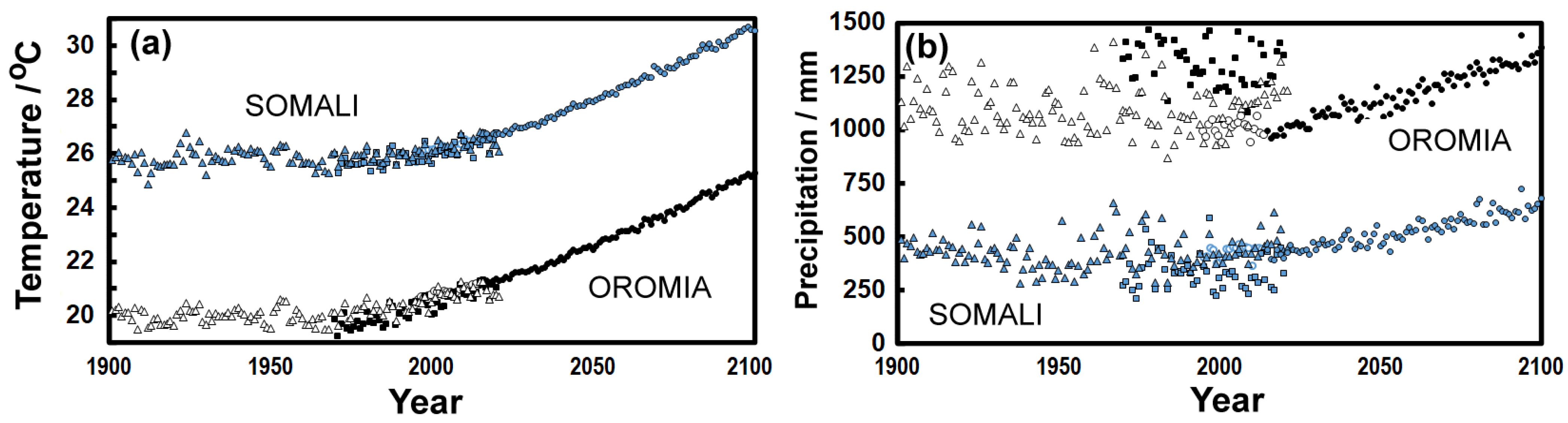
The change in average temperature since 1901 shows a significant rise of about 0.78 °C per century (Kendall τ = 0.44; p2 < 0.0001) as seen in the early half of Figure 4a constructed from regridded observations [21]. Climate is hotter in the more desert-like Somali regional state than in Oromia. The projected temperatures at Dirre Sheikh Hussein are likely to lie between these two values. The changes projected for the future are under the extreme RCP8.5 scenario that represent a kind of worst case, so indicate a rise of ~4 *C over the coming century.
The change in precipitation is shown in Figure 4b and suggests an increase in both Oromia and Somali regional states, but the results are more variable year-to-year in the observational record. These regridded historical observations, especially in Oromia hint at a decline through the 20th century which agrees with the work of Tolossa et al. [26] in Eastern Ethiopia. Through the 21st century, modelling suggests increased precipitation. Obviously, the more desert-like Somali has much lower rainfall, although the annual amount might increase in the future.
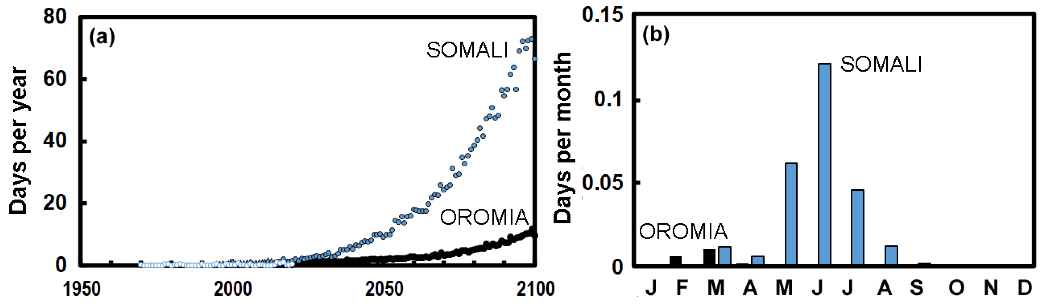
Very hot days can affect those visiting the shrine. In the future the RCP8.5 scenario would suggest a dramatic increase in the number of very hot days (>40 *C), particularly in Somali State (Figure 5a). In the reanalysis data, these hot days in Somali occur mid-year (Figure 5b), which is the hottest time of the year, although in Oromia they seem to occur earlier than in Somali State (also see Figure 3a). Fortunately, the weather has generally mild temperatures and is dry when the Birthday of Sheikh Hussein is celebrated in January.
Water represents a key threat to heritage [27], and as seen in Figure 4b there is likely to be a small increase in precipitation across the 21st century. However, the total annual amount does not necessarily best represent the threat to heritage. In a changing climate total precipitation can decline, yet individual falls of rain though less frequent become heavier [28]. There is a sharp increase in the number of very wet days each year when precipitation exceeds 20 mm in Oromia State (Figure 6a), rising to nine days per annum by the end of the 21st century. However, the reanalysis data (1970–2020) is discordant and very scattered compared with the CMIP6 estimates. The number of very wet days also increases in Somali State (Figure 3a) from 1970 and on through the 21st century, though not as steeply as in Oromia.
The annual RH values (Figure 6b) from the reanalysis data (1970–2020) are rather scattered, but the longer-term change from the CMIP6 projections suggest a slight increase. Resistance of wood to decay, and potentially attack by insects and mould, is represented by the Scheffer index, which has been ~45 at Ginir over the last century. This is a relatively low value and suggests only a medium risk of decay [30]. The index is likely to increase across much of Ethiopia (Figure 6c,d), suggesting a potentially enhanced risk of timber decay. As Tola [1] remarks: “The wood used for the roof was particularly resistant and made it possible for the structure/buildings to stand for centuries”, so it is important that such longevity continues.
4. Discussion
The climate of Ethiopia is changing, and Oromia State is likely to get warmer in the coming century. Temperatures increased by more than 1 °C over the last century, and that seems set to increase, though changes in the number of hot days could be dramatic in Somali State over the coming century.
Temperature increases of a few degrees do not directly harm inorganic materials, although small changes may be amplified via phase changes such as those involved through freezing [31,32] or salt crystallisation [33,34], or enhanced by biological activity [35,36,37], visitor behaviour or the management regime [38]. At Dirre Sheikh Hussein, the pilgrims seem especially vulnerable to climate change. One the religious day is fixed by the saint’s birthday (first Tuesday in January). The second festival takes place in the last month of the Muslim year, Ḏū al-Ḥijja, celebrating the end the haj with the feast Id al-Kabir. The Islamic calendar is based on 12 lunar months (i.e., a year of 354 or 355 days), so the date of this festival, is fixed by the moon and thus takes place on a different date each year. This means, in some future years, climate may be amenable, but in others the time may be prone to heavy rain or heat waves. This will involve careful management by the darga to address the changing, though somewhat predictable, conditions under which they welcome pilgrims and the widening interest in tourism [39,40,41].
Regular repainting with white ash seems an important local approach to maintenance, and probably lowers the solar gain of the building, keeping the interior cooler than otherwise. The indoor temperatures are likely to buffer to the local mean, though there are no measurements available to allow the comfort levels to be assessed.
Annual precipitation for the region showed little change over the last century, yet Ethiopia may be a few percent wetter by the end of the 21st century. However, it is not really the annual rainfall amount that is critical, it is more likely that the intensity will be most relevant to heritage. Rainfall leads to drainage marks, already to some extent evident, on the building walls (Figure 7a); these markings are perhaps enhanced through the use of animal fat on beams in the building. The future is likely to be accompanied by microbiological growth that could increase in line with a small rise in the Scheffer index (Figure 6c,d). In future, shifting patterns of rainfall could result in staining of walls where this had not been experienced before. Stains are also evident where people touch or kiss the walls (Figure 7b), or at times paint surfaces with butter and blood, an activity not in keeping with principles adopted at the site. Although humidity has a distinct annual cycle and may increase (Figure 6b) this seems too small to interfere with the conservation of wooden objects associated with the pilgrimage in the library or museum e.g., musical instruments, Ulee Sheikh Hussein (ritual Y-shaped sticks) etc.
However, in future there may often be heavier rainfall events, and floods and droughts are likely to increase in frequency, but there is considerable uncertainty about this [42,43]. During heavy falls of rain, which flood the site, the drainage system can be overwhelmed, and the water pools (Figure 7c) overfilled. It is important to maintain both drainage and pools as water harvesting is an important adaptation to climate change [26].
Changes in soil moisture could enhance soil erosion and exacerbate the loss of surrounding vegetation. Soil water cycles are set to change [16] and evapotranspiration will probably be more rapid. Any change in this soil water could also lead to ground movement, so structures may shift, and changes perhaps revealed as widening cracks in walls, gates, etc. (Figure 7d). The dry jointed limestone masonry, bonded with a lime and mud mortar and plastered, is likely to be subject to desiccation, so may crack (Figure 7e). However, the RH changes across the coming century seem small (Figure 6b), so this process is unlikely to get worse. The water table or soil moisture is also likely to change. In particular there is enthusiasm to create a nursery for indigenous trees, so these might be planted at the site, which is likely to have generally positive outcomes in reducing run-off etc.
This study has combined traditional meteorological parameters with observations of deterioration at a local level. With more detailed records of local weather from Dirre Sheikh Hussein it should be possible to tune data to heritage climates that typically better represent pressures on built heritage [29]. In the current study climate data was mostly recorded some distance from the site, so can give only a general sense of conditions. However, it is often necessary in remote places to work in the absence of on-site observations of both damage and environmental conditions. This makes satellite data and global models especially useful [25,29]. Nevertheless, translating global data to the local level is challenging and may require diverse local observations to be incorporated [44]. It is especially needed where conservation research is limited, as it has been with the Islamic sites in the Horn of Africa [25,45].
The results found in this paper show parallels with other work on conservation needs in Ethiopia as seen at other important sites: e.g., Fasil Ghebb near Gondar [46,47] the historic fortified town of Harar Jugol [48,49], the site at Harlaa [45] and the rock-hewn churches of Lalibela [50,51,52]. A number of themes identified at Dirre Sheikh Hussein seem to be repeated at these sites, such as damage from invasive restoration [52], lack of local expertise, improper choice of materials [52] and a lack of focussed research [45]. The deterioration by rain and the need to reduce its impact on buildings [52], along with wide ranges in temperature and biological activity on surfaces [51] are evident. The sites often represent a living heritage in use by the community [51,52], so can show a sense of community recognition of the need for conservation [48,49,52].
5. Conclusions
The site at Dirre Sheikh Hussein represents a place where architectural and artistic achievements established major monuments. The site is a living religious centre that welcomes large numbers of pilgrims and encourages social interaction and cultural exchanges across many different backgrounds, promoting peace and tolerance. The wider heritage zone reveals a long history of human protection of the natural environment, so can teach us about sustainability, reflected as much in its care for flora and fauna as in its representation of traditional techniques of water harvesting. The site can additionally be a place for tourism given the improved connections with other regions following the development of the Seru-Shenen-Sheikh Hussein Road in 2015.
Despite the attractiveness of this major site, it remains vulnerable. It sits at the edge of two climate types susceptible to change. Although there is much enthusiasm for its protection, both locally and more widely in Ethiopia, there is a lack of human and financial resources, so there are attempts under way to gain international funding that will help local people gain knowledge through seminars and to support a range of their conservation activities. Although the number of conservation professionals is growing, the country is vast, and there is much to protect. As shown in our analysis this vulnerability has not been well studied and there is limited monitoring at the site to support evidence-based management plans. Condition reports are available, but may not be at the level of detail that can reveal likely longer term changes at fine scale. The absence of detailed site plans and meteorological data means that it is hard to assign observed forms of damage to distinct environmental pressures. The future demands such work, although on the positive side, stakeholders are enthusiastic about engaging with protection and maintenance at the site. Awareness of the need to conserve this most significant site has fortuitously increased, just when it is likely to face new threats.
Supplementary Materials
The following supporting information can be downloaded at: https://0-www-mdpi-com.brum.beds.ac.uk/article/10.3390/heritage5030139/s1, Figure S1: Map of the site; Table S1: List of sacred objects.
Author Contributions
Conceptualization, H.G.T.; methodology, P.B.; formal analysis, P.B.; field investigation, H.G.T.; writing—original draft preparation, P.B.; writing—review and editing, H.G.T. and P.B.; visualisation, P.B. All authors have read and agreed to the published version of the manuscript.
Funding
This research received no external funding.
Institutional Review Board Statement
Not applicable.
Informed Consent Statement
Not applicable.
Data Availability Statement
Data is freely available at the URLs denoted in the text.
Acknowledgments
We would like to thank: H/Abdulnasir Sh/Ahmed and H/Abdurahman (Abba Karra) and the members of Darga for providing information; Abdula’alim Abubakar for giving us access to the Dirre Sheikh Hussein meteorological records; Abduljalil Anwar Hussien (East Bale Zone Culture and Tourism Office expert) for providing information; Abdi Edao, Executive Director of the Wako Gutu Foundation for facilitating logistics support and Evangelos Kyriakidis, Director of the Heritage Management Organization for technical support.
Conflicts of Interest
The authors declare no conflict of interest.
References
- Tola, S. The conservation of Dirre Sheikh Hussein Heritage Site, Oromia Culture and Tourism Bureau, Ethiopia. 2009. Available online: https://www.hdm.lth.se/fileadmin/hdm/alumni/papers/CMHB_2008b/10_ETH_Sintayehu_Tola_Kenea_Sheikh_Hussein_Heritage_Site.pdf (accessed on 29 August 2022).
- UNESCO. Dirre Sheik Hussein Religious, Cultural and Historical Site. 2011. Available online: https://whc.unesco.org/en/tentativelists/5649/#:~:text=Description,East%20countries%2C%20twice%20a%20year (accessed on 29 August 2022).
- Semu, K.T. The culture of accommodating diversity embedded in the sufi saint cult of Bale, Ethiopia: A historical overview. J. Equity Sci. Sustain. Dev. 2022, 5, 29–45. [Google Scholar]
- Ta’a, T. Religious beliefs among the Oromo: Waaqeffannaa, Christianity and Islam in the context of ethnic identity, citizenship and integration. Ethiop. J. Soc. Sci. Humanit. 2012, 8, 87–111. [Google Scholar]
- Semu, K.T. Dynamics of the cult of Sheik Hussein of Bale, Ethiopia: Its course and curse of the extremists, a historical perspective. Ethiop. J. Soc. Sci. Humanit. 2016, 12, 63–101. [Google Scholar]
- Donaldson Smith, A. Through Unknown African Countries: The First Expedition from Somaliland to Lake Rudolf; India Office: London, UK, 1897. [Google Scholar]
- Oyst1. Available online: https://commons.wikimedia.org/wiki/File:Sheikh_Hussein.jpg (accessed on 27 August 2022).
- Akbaba, A.; Ahmed, M.J. Identifying and mapping of halal tourism resources and routes in Ethiopia. Int. J. Contemp. Tour. Res. 2021, 5, 13–34. [Google Scholar]
- Aseres, S.A. Key stakeholders roles and tourism development in Bale Zone, Ethiopia. Int. J. Bus. Manag. Adm. 2016, 1, 2–4. [Google Scholar]
- Esubalew, B.; Solomon, N.; Akele, B. Religious tourism practices, potentials, and challenges: The case of Dire Sheikh Hussein Area, South East Ethiopia. J. Soc. Sci. 2020, 48, 3. [Google Scholar]
- Østebø, T. Local reforms and the search for change: The emergence of Salafism in Bale, Ethiopia. Africa 2011, 81, 628–648. [Google Scholar] [CrossRef]
- Østebø, T. Localising Salafism. Religious Change among Oromo Muslims in Bale, Ethiopia; Brill: Leiden, The Netherlands, 2012. [Google Scholar]
- Tadese, M.; Kumar, L.; Koech, R. Long-term variability in potential evapotranspiration, water availability and drought under climate change scenarios in the Awash River Basin, Ethiopia. Atmos 2020, 11, 883. [Google Scholar] [CrossRef]
- Gizaw, M.S.; Gan, T.Y. Impact of climate change and El Niño episodes on droughts in sub-Saharan Africa. Clim. Dyn. 2017, 49, 665–682. [Google Scholar] [CrossRef]
- Jenkins, K.; Warren, R. Quantifying the impact of climate change on drought regimes using the standardised precipitation index. Theor. Appl. Climatol. 2015, 120, 41–54. [Google Scholar] [CrossRef]
- Muluneh, A. Impact of climate change on soil water balance, maize production, and potential adaptation measures in the Rift Valley drylands of Ethiopia. J. Arid. Environ. 2020, 179, 104195. [Google Scholar] [CrossRef]
- Demie, G.; Negash, M.; Awas, T. Ethnobotanical study of medicinal plants used by indigenous people in and around Dirre Sheikh Hussein heritage site of South-eastern Ethiopia. J. Ethnopharmacol. 2018, 220, 87–93. [Google Scholar] [CrossRef] [PubMed]
- Orr, S.A.; Richards, J.; Fatorić, S. Climate change and cultural heritage: A systematic literature review (2016–2020). Hist. Environ. Policy Pract. 2021, 12, 434–477. [Google Scholar] [CrossRef]
- Simpson, N.P.; Clarke, J.; Orr, S.A.; Cundill, G.; Orlove, B.; Fatorić, S.; Sabour, S.; Khalaf, N.; Rockman, M.; Pinho, P.; et al. Decolonizing climate change–heritage research. Nat. Clim. Chang. 2022, 12, 210–213. [Google Scholar] [CrossRef]
- Conway, D.; Mould, C.; Bewket, W. Over one century of rainfall and temperature observations in Addis Ababa, Ethiopia. Int. J. Climatol. 2004, 24, 77–91. [Google Scholar] [CrossRef]
- Harris, I.; Osborn, T.J.; Jones, P.; Lister, D. Version 4 of the CRU TS monthly high-resolution gridded multivariate climate dataset. Sci. Data 2020, 7, 109. [Google Scholar] [CrossRef] [Green Version]
- Lisø, K.R.; Hygen, H.O.; Kvande, T.; Thue, J.V. Decay potential in wood structures using climate data. Build. Res. Inf. 2006, 34, 546–551. [Google Scholar] [CrossRef]
- Scheffer, T.C. A climate index for estimating potential for decay in wood structures above ground. Prod. J. 1971, 21, 25–31. [Google Scholar]
- Gwynn, C.W. A journey in Southern Abyssinia. Geogr. J. 1911, 38, 118. [Google Scholar] [CrossRef]
- Khalaf, N.; Insoll, T. Monitoring Islamic archaeological landscapes in Ethiopia using open source satellite imagery. J. Field Archaeol. 2019, 44, 401–419. [Google Scholar] [CrossRef]
- Tolossa, T.T.; Abebe, F.B.; Girma, A.A. Rainwater harvesting technology practices and implication of climate change characteristics in Eastern Ethiopia. Cogent Food Agric. 2020, 6, 1724354. [Google Scholar] [CrossRef]
- Sabbioni, C.; Brimblecombe, P.; Cassar, M. (Eds.) The Atlas of Climate Change Impact on European Cultural Heritage: Scientific Analysis and Management Strategies; Anthem Press: London, UK, 2010. [Google Scholar]
- Brimblecombe, P. Refining climate change threats to heritage. J. Inst. Conserv. 2014, 37, 85–93. [Google Scholar] [CrossRef]
- Richards, J.; Brimblecombe, P. Moisture as a driver of long-term threats to timber heritage. Part I: Changing heritage climatology. Heritage 2022, 5, 1929–1946. [Google Scholar] [CrossRef]
- Tajet, H.T.T.; Hygen, H.O. Potential risk of wood decay. 2017. Available online: https://www.met.no/publikasjoner/met-report/met-report-2017/_/attachment/download/c7df823f-5c98-4968-81fc-694e6fb6c49b:f495ddf4c9d7358398f610f0ed735c8382dad535/MET-report-08-2017.pdf (accessed on 3 May 2022).
- Abdelhamid, M.M.A.; Li, D.; Ren, G.; Zhang, C. Estimating deterioration rate of some carbonate rocks used as building materials under repeated frost damage process, China. Adv. Mater. 2020, 2020, 3826128. [Google Scholar] [CrossRef]
- Grossi, C.M.; Brimblecombe, P.; Harris, I. Predicting long term freez—Thaw risks on Europe built heritage and archaeological sites in a changing climate. Sci. Total Environ. 2007, 377, 273–281. [Google Scholar] [CrossRef]
- Godts, S.; Orr, S.A.; Desarnaud, J.; Steiger, M.; Wilhelm, K.; De Clercq, H.; Cnudde, V.; De Kock, T. NaCl-related weathering of stone: The importance of kinetics and salt mixtures in environmental risk assessment. Herit. Sci. 2021, 9, 44. [Google Scholar] [CrossRef]
- Grossi, C.M.; Brimblecombe, P.; Menéndez, B.; Benavente, D.; Harris, I.; Déqué, M. Climatology of salt transitions and implications for stone weathering. Sci. Total Environ. 2011, 409, 2577–2585. [Google Scholar] [CrossRef]
- Brimblecombe, P.; Hayashi, M. Pressures from long term environmental change at the shrines and temples of Nikkō. Herit. Sci. 2018, 6, 27. [Google Scholar] [CrossRef]
- Branysova, T.; Demnerova, K.; Durovic, M.; Stiborova, H. Microbial biodeterioration of cultural heritage and identification of the active agents over the last two decades. J. Cult. Herit. 2022, 55, 245–260. [Google Scholar] [CrossRef]
- Cappitelli, F.; Cattò, C.; Villa, F. The control of cultural heritage microbial deterioration. Microorganisms 2020, 8, 1542. [Google Scholar] [CrossRef]
- Brimblecombe, P. Visitor responses and climate change. In Cultural Heritage from Pollution to Climate Change; Lefevre, R., Sabbioni, C., Eds.; Edipuglia: Bari, Italy, 2016; pp. 73–80. [Google Scholar]
- Aynalem, S.; Akele, B.; Alemayehu, H.; Molla, G. Assessment and identification of the tourism resources of Bale Zone, Ethiopia. J. Hosp. Tour. Manag. 2015, 4, 1000176. [Google Scholar]
- Bayih, B.E.; Tola, M.W. Practices and challenges of promoting major tourism destinations of Bale Zone for sustainable tourism development in Ethiopia. Afr. J. Hosp. Tour. Leis. 2017, 6, 15. [Google Scholar]
- Dagnachew, S.E. Interfaith tourism in Ethiopia: An opportunity for socio-economic development and peace-building? In Peace Journeys: A New Direction in Religious Tourism and Pilgrimage Research; McIntosh, I.S., Haddah, N.F., Munro, D., Eds.; Cambridge Scholars Publishing: Newcastle-on-Tyne, UK.
- Gummadi, S.; Rao, K.P.; Seid, J.; Legesse, G.; Kadiyala, M.D.; Takele, R.; Amede, T.; Whitbread, A. Spatio-temporal variability and trends of precipitation and extreme rainfall events in Ethiopia in 1980–2010. Theor. Appl. Climatol. 2018, 134, 1315–1328. [Google Scholar] [CrossRef]
- Seleshi, Y.; Zanke, U. Recent changes in rainfall and rainy days in Ethiopia. Int. J. Climatol. 2004, 24, 973–983. [Google Scholar] [CrossRef]
- Brimblecombe, P.; Richards, J. Moisture as a driver of long-term threats to timber heritage. Part II: Risks imposed at local sites. Heritage 2022. [Google Scholar]
- Insoll, T.; Khalaf, N.; MacLean, R.; Parsons-Morgan, H.; Tait, N.; Gaastra, J.; Beldados, A.; Pryor, A.J.; Evis, L.; Dussubieux, L. Material cosmopoitanism: The entrepot of Harlaa as an Islamic gateway to eastern Ethiopia. Antiquity 2021, 95, 487–507. [Google Scholar] [CrossRef]
- Wubneh, M. Urban resilience and sustainability of the city of Gondar (Ethiopia) in the face of adverse historical changes. Plan Perspect. 2021, 36, 363–391. [Google Scholar] [CrossRef]
- Woredekal, S. Restoration of historical monuments of Gondar. Ann. D’éthiopie 1985, 13, 119–133. [Google Scholar] [CrossRef]
- Asante, B. Community engagement in cultural heritage management—Case studies of museums in Harar and Addis Ababa, Ethiopia. 2008. Available online: https://repository.kulib.kyoto-u.ac.jp/dspace/bitstream/2433/137081/1/ytiik00063.pdf (accessed on 27 August 2022).
- Tarsitani, B.A. Merging past and present in the Museums of Harar, Ethiopia. Nilo-Ethiop. Stud. 2009, 13, 1–16. [Google Scholar]
- Woldeyes, Y.G. Preliminary Report: Conservation Concerns for the Lalibela Rock Hewn Churches. IIEE Ethiopia. 2018. Available online: https://espace.curtin.edu.au/bitstream/handle/20.500.11937/75855/76057.pdf (accessed on 12 September 2022).
- Delmonaco, G.; Margottini, C.; Spizzichinom, D. Analysis of rock weathering and conservation strategies for rock-hewn churches of Lalibela (Ethiopia). Prot. Hist. Build. PROHITECH 2009, 9, 137–142. [Google Scholar]
- Negussie, E. Conserving the rock-hewn churches of lalibela as a world heritage site: A case for international support and local participation. In Proceedings of the Changing World, Changing Views of Heritage: Heritage and Social Change, ICOMOS Scientific Symposium, Dublin, Ireland, 30 October 2010; Theme 3. pp. 1–10. [Google Scholar]
Figure 1.
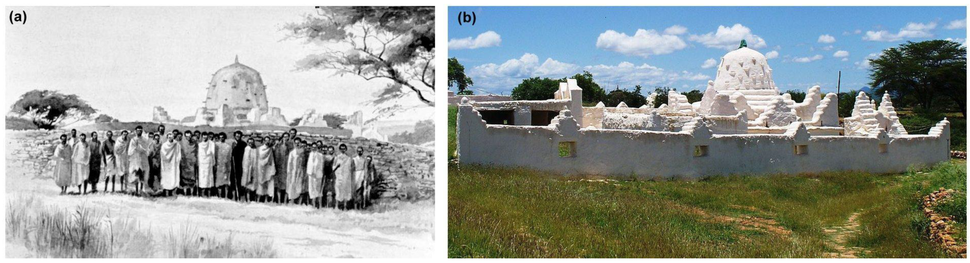
(a) Photograph of walls of the shrines at Dirre Sheikh Hussein in the 1890s by F. Gillett, somewhat retouched when published in Through Unknown African Countries [6] and (b) a photograph from a similar position taken in 2010 [7] that hints at more carefully plastered walls.

Figure 2.
Map of Ethiopia with locations mentioned in the text sites along with Köppen classification of climate. Am, tropical monsoon climate; Aw, tropical wet and dry climate; BWh, hot desert climate; BSh, hot semi-arid climate; Cwa monsoon-influenced humid subtropical climate; Cwb, subtropical highland climate. Adapted from Adam Peterson’s map of Köppen climates of Ethiopia. Inset shows Africa, with Ethiopia in black.

Figure 3.
(a) Monthly average temperature observations for Robe near Goba (white), Ginir (grey) Oromia (black) and Somali (blue) regional states, with some 2022 values for Dirre Sheikh Hussein as brown diamonds. (b) Observed monthly average precipitation for Robe, Ginir, Oromia and Somali. (c) Observed monthly average RH for Robe and Ginir. (d) Observed monthly direct solar radiation for Ginir. Note: time windows for observations are given in the Section 2. Note Months are abbreviated to the three initial letters except in (d) where six of the months are a single letter.

Figure 4.
(a) Annual average temperature for Oromia (black or white symbols) and Somali (blue) for the observations 1901–2020 (triangles), reanalysis 1970–2020 (squares) historic CMIP6 1995–2015 (open circles with white interiors) 2015–2100 (closed circles with black or blue interiors) projected under CMIP6. (b) Annual precipitation for Oromia regional state and Somali coded as in (a).

Figure 5.
(a) Days each year when temperature exceeds 40 °C in Oromia (black) and Somali (blue) for the reanalysis period 1970–2020 as squares and projections 2015–2100 as circles with blue or black interiors. (b) Days each month > 40 °C in Oromia (black) and Somali (blue) for the reanalysis period 1970–2020. Note months abbreviated to single letters.

Figure 6.
(a) Days each year when precipitation exceeds 20 mm in Oromia (black) and Somali (blue) for the reanalysis 1970–2020 as squares, historical analysis 1995–2015 as circles with white interiors and CMIP6 projections 2015–2100 as closed circles. (b) Average annual RH in Oromia and Somali for the reanalysis, historical analysis and projections. (c) Scheffer index (Sch) in 1850–1879 [29] and (d) the projected change in Scheffer index (ΔSch) between 2070–2099 and 1859–1879 [29].

Figure 7.
(a) Drainage marks on the walls of shrine. (b) Staining in places where worshippers kiss the walls of the shrine or rub their hands on it, sometimes with butter and blood which changes the colour. (c) Haro Luku pond built by Sheikh Hussein in the 10th century containing holy water (Zamzama), used only for drinking purposes. (d) Cracked pillar in the shrine, probably because of rain entering from the roof (e) Crazed walls of the shrine. Photographs by author H.G.T., August 2022.

Publisher’s Note: MDPI stays neutral with regard to jurisdictional claims in published maps and institutional affiliations. |
© 2022 by the authors. Licensee MDPI, Basel, Switzerland. This article is an open access article distributed under the terms and conditions of the Creative Commons Attribution (CC BY) license (https://creativecommons.org/licenses/by/4.0/).
Share and Cite
MDPI and ACS Style
Tola, H.G.; Brimblecombe, P. Environmental Pressures at Dirre Sheikh Hussein Sanctuary. Heritage 2022, 5, 2661-2672. https://0-doi-org.brum.beds.ac.uk/10.3390/heritage5030139
AMA Style
Tola HG, Brimblecombe P. Environmental Pressures at Dirre Sheikh Hussein Sanctuary. Heritage. 2022; 5(3):2661-2672. https://0-doi-org.brum.beds.ac.uk/10.3390/heritage5030139
Chicago/Turabian StyleTola, Habtamu Gizawu, and Peter Brimblecombe. 2022. "Environmental Pressures at Dirre Sheikh Hussein Sanctuary" Heritage 5, no. 3: 2661-2672. https://0-doi-org.brum.beds.ac.uk/10.3390/heritage5030139