


From 3D Point Cloud to an Intelligent Model Set for Cultural Heritage Conservation

1
Department of Steel Structures and Structural Mechanics, Politehnica University Timișoara, Piața Victoriei 2, 300006 Timișoara, Romania
2
Department of Engineering and Geology, University “G. d’Annunzio” of Chieti-Pescara, 65127 Pescara, Italy
3
Dipartimento di Ingegneria Civile, Ambientale, del Territorio, Edile e di Chimica, Polytechnic University of Bari, via E. Orabona 4, DICATECh, 70125 Bari, Italy
4
Department of Overland Communication Ways, Foundations and Cadastral Survey, Politehnica University Timișoara, Piața Victoriei 2, 300006 Timișoara, Romania
*
Author to whom correspondence should be addressed.
Heritage 2024, 7(3), 1419-1437; https://0-doi-org.brum.beds.ac.uk/10.3390/heritage7030068
Submission received: 26 February 2024
/
Accepted: 8 March 2024
/
Published: 10 March 2024
(This article belongs to the Topic The Future in the Restoration and Conservation of Cultural Heritage: Towards Green and Innovative Approaches to the Processes)
Abstract
:Cultural heritage conservation demands interdisciplinary and complex documentation and analysis while facing increasing pressure to adopt sustainable and productive practices. This paper bridges these gaps by proposing a methodology and a set of requirements for Building Information Modeling (BIM) models aligned with European directives for sustainability and productivity in the Architecture, Engineering, and Construction (AEC) sector. Leveraging 3D scanning and intelligent models, we establish information needs specific to conservation, encompassing material properties, historical data, and decay analysis. Interoperability, compatibility with advanced analytical tools, and open-source formats are emphasized for seamless data integration and accessibility. We further introduce two use cases for BIM-enabled heritage conservation, illustrating the application of our proposed methodology in real-world scenarios. These cases exemplify how BIM models cater to the specific needs of cultural heritage sites, from their initial condition assessment to ongoing preservation efforts. Through these examples, we demonstrate the adaptability of BIM technology in capturing and managing the complex information associated with heritage conservation, including structural details, material characteristics, and historical significance. Our work highlights the potential of BIM to revolutionize heritage conservation practices, offering a digital backbone for documentation, analysis, and management that aligns with sustainability and productivity goals.
1. Introduction
The World Heritage Convention charges the World Heritage Centre (WHC) and its advisory bodies with reporting on the state of conservation of specific World Heritage sites facing threats. In a recent report [1], the WHC delved into this critical task, analyzing the factors negatively impacting these cultural treasures. This analysis, based on various threat groups, heritage categories (natural, mixed, and cultural), and regional distributions, serves as a crucial step in developing a comprehensive computerized information system on the state of conservation. This system aims to provide users with a centralized access point to the vast array of documents related to specific properties, currently scattered across various formats and online platforms. The report paints a concerning picture, highlighting the ever-present threats to cultural heritage and their diverse nature. This comprehensive analysis empowers users to readily access and analyze these threats, paving the way for more informed and targeted conservation efforts. The identified threats most likely to affect cultural properties include the following: (i) Management Systems/Management Plan (69%), with missing or flawed management plans posing the greatest risk, often stemming from a lack of proper legal frameworks for protection; (ii) housing (49%), referring to uncontrolled housing development that can physically damage sites and alter their cultural landscapes; and (iii) weak legal framework (28%) that leaves heritage vulnerable to exploitation and neglect. These findings highlight the critical role of effective management in safeguarding cultural heritage. Missing or flawed management plans leave sites vulnerable, while inadequate legal frameworks create loopholes for exploitation. Even well-intentioned conservation efforts can become threats if poorly planned and implemented.
Besides the above-mentioned threats, natural impact, lack of use and maintenance, and even tourism [2] pose threats to cultural heritage and can lead to significant structural damage. In Mexico, a total of 1877 properties were listed by the National Institute of Anthropology and History as damaged due to seismic activity (i.e., 1796 historic monuments, 56 museums and cultural centers, 22 archeological zones, and 2 artistic monuments).
Engaging with heritage ignites a personal and collective understanding of shared roots, creating a space for meaningful connection and fostering pride in a shared narrative. Whether through immersive storytelling, community-driven restoration projects, or vibrant cultural celebrations, shared experiences with heritage strengthen social bonds, promote empathy, and build a sense of collective responsibility for safeguarding precious legacies. This sense of belonging fuels collective action, allowing communities to collaborate in preserving and interpreting their heritage, fostering a shared purpose, and enriching the social fabric. Ultimately, the tangible and intangible elements of cultural heritage serve as powerful anchors, reminding us of who we are, where we come from, and the values that bind us together, ultimately weaving a tapestry of cultural richness and connection [3].
Beyond individual and community connection, cultural heritage blossoms when it serves as a beacon of understanding and dialogue between diverse cultures. By engaging with the traditions, values, and stories of others, we cultivate mutual respect, appreciation, and empathy. It acts as a bridge, transcending language and borders to foster inter-cultural communication and dismantling stereotypes. This exchange opens doors to learning from time-tested solutions within different heritages, offering valuable insights for conflict prevention and reconciliation. It allows us to see ourselves in others, fostering compassion and paving the way for peaceful coexistence [4]. Furthermore, cultural heritage acts as a potent economic engine, attracting tourists seeking unique experiences and generating jobs within local communities. This influx of resources fuels economic growth, while simultaneously revitalizing heritage sites and preserving them for future generations. From artistic inspiration to innovative practices, cultural heritage also enriches social and cultural life, fueling education and sparking creative expression. It serves as a living laboratory, reminding us of the richness and resilience of the human spirit and acting as a springboard for future innovation. By valuing and actively engaging with cultural heritage, we unlock its power to create a more inclusive, prosperous, and harmonious world.
In this context, 3D scanning has emerged as a revolutionary tool in the digitalization of cultural heritage buildings, offering a wealth of advantages for preservation, research, and accessibility [5]. This technology captures the intricate details of structures, both intricate carvings and weathered surfaces, creating high-fidelity digital models that transcend traditional documentation methods. Furthermore, 3D scans enable detailed analysis of architectural styles, construction techniques, and potential damage, informing restoration efforts and ensuring the longevity of these irreplaceable treasures. Additionally, these digital models democratize access to cultural heritage, allowing for virtual tours and educational experiences, fostering cultural understanding and appreciation for a wider audience. In essence, 3D scanning plays a crucial role in safeguarding our cultural heritage for future generations, preserving not just the physical structures but also the stories and knowledge they embody. Kantaros et al. [6] explored the integration of 3D scanning and printing technologies in cultural heritage preservation, highlighting their capacity to create detailed digital and physical replicas of artifacts and structures. These technologies offer significant advantages for documentation, analysis, restoration, and public engagement, enabling the non-invasive preservation of heritage and accessibility for educational and research purposes. Gajski et al. [7] presented a methodology for creating stereoscopic visualizations of archaeological artifacts, specifically focusing on the Vučedol Dove, using Blender software. It explores different stereoscopic techniques, such as anaglyph and polarization, to enhance the depth perception and realism of 3D models, making them more accessible and engaging for both researchers and the public. The findings demonstrate that stereoscopic visualizations can significantly improve the interpretation and appreciation of archaeological artifacts, suggesting a promising tool for cultural heritage preservation and education. Skublewska et al. [8] explored the utilization of 3D digital technologies in preserving intangible cultural heritage (ICH), finding diverse applications across practices like craftsmanship and dance. They identified a range of technologies, including 3D visualization and augmented reality, emphasizing their potential in ICH documentation and education. Despite geographical and technological diversity in the research, gaps such as the need for studies on technology effectiveness and broader geographical research coverage are highlighted. The findings suggest a promising but underexplored area, advocating for further investigation into integrating 3D technologies with traditional preservation methods. The authors concluded that 3D digital technologies hold significant promise for ICH preservation, offering innovative approaches for documentation, recovery, and presentation. However, insufficient research on the technologies’ effectiveness and the need for broader geographical coverage in studies hinders adoption.
The field of cultural heritage preservation is embracing a new era of intelligent documentation with the development of Building Information Modeling (BIM), incorporating OpenBIM® [9] concepts proposed by buildingSMART. This innovative approach consolidates information from diverse sources, including 3D scans, historical documents, and archaeological discoveries, into a single, dynamic model. Using this approach, a virtual environment can be defined where intricate details captured by 3D scans seamlessly blend with historical accounts and unearthed artifacts, creating a comprehensive understanding of a heritage site’s past and present. OpenBIM® standards ensure accessibility and collaboration, allowing experts from various disciplines—architects, historians, archaeologists—to contribute and share their knowledge within the model. This fosters a deeper understanding of the site’s evolution, construction techniques, and cultural significance. Moreover, intelligent features within the BIM can analyze data, identify potential risks, and support informed decision-making for restoration and conservation efforts. This paves the way for proactive preservation, ensuring the longevity of these irreplaceable treasures for future generations. OpenBIM® concepts empower cultural heritage professionals to not only document the past but also create an interactive platform for education, research, and public engagement, fostering a deeper appreciation for our shared history. As this technology matures, intelligent BIMs promise to revolutionize the way we understand, conserve, and share the stories embedded within our cultural heritage [10].
The transformation of the point cloud into a BIM model in the field of cultural heritage, especially in complex architectures, continues to be the subject of experimentation in order to identify automatisms that can make this process fast, reliable, and accurate [11]. Moreover, this process is not massively applied for the management and maintenance of cultural heritage assets, very often deferring to a 2D approach with information sheets. Bridging the gap between BIM and cultural heritage conservation demands a nuanced approach that respects the unique needs of historical structures while leveraging the strengths of modern technology. While BIM excels in managing information for new construction projects, adapting it to the complexities of heritage sites requires carefully considered adjustments, i.e.:
- Heterogeneity of Data: Unlike standardized building components, cultural heritage sites present a diverse range of materials, construction techniques, and historical alterations. Capturing this complexity necessitates flexible data structures within the BIM model;
- Time Dimension: While BIM typically focuses on the construction and operation phases of a building, heritage conservation demands understanding time evolution on a larger scale. Integrating historical documents, archaeological data, and past restoration records into the model requires advanced time-tracking capabilities;
- Reversibility and Authenticity: Conservation interventions prioritize minimal intervention and reversibility of implemented solutions. BIM models need to accommodate the ability to track changes, document original materiality, and facilitate future adaptations while preserving authenticity;
- Community Engagement: Heritage sites hold cultural and social significance beyond their physical elements. BIM models should integrate information relevant to stakeholders and facilitate community engagement in the conservation process.
By addressing these challenges, the present paper aims to achieve the following:
- Propose innovative BIM-based solutions that can contribute to a more effective and efficient conservation process;
- Establish guidelines and best practices in integrating BIM into heritage projects workflows, ensuring data integrity and informed decision-making;
- Develop a set of comprehensive information requirements for a streamlined process from 3D scanning to solution implementation and, ultimately, operation;
- Promote accessibility and collaboration by advocating for openBIM® standards and stakeholder engagement to foster collaboration among diverse disciplines involved in heritage conservation.
2. Requirements for Cultural Heritage Conservation
2.1. BIM Requirements for Cultural Heritage
In essence, BIM for cultural heritage goes beyond mere bricks and mortar. It weaves together a tapestry of data, preserving the physical fabric and intangible spirit of the site for future generations to explore, understand, and appreciate. BIM allows the structured integration of both geometric and non-geometric information (including tangible and intangible values) as well as external documents into a single model, thereby becoming a central hub for all information relating to a historic asset [12]. By defining clear targets for each information area based on conservation goals and BIM needs, the execution plan can guide data collection and ensure that it supports informed decision-making throughout the restoration process. Remember, this is not an exhaustive list, and specific needs may vary depending on the unique characteristics of your cultural heritage site. Heritage asset management differs from traditional asset management in its approach. Where traditional asset management is driven by definitive lifecycle costs from creation or acquisition to disposal, the management of heritage assets is based on the conservation principles of minimal intervention and ongoing conservation maintenance for preservation. The overall purpose of heritage asset management strategies might include [13]:
- Conserving cultural heritage on behalf of the nation;
- Promoting access to cultural heritage and enhancing the visitor experience;
- Informing and educating the public about cultural heritage and its significance;
- Establishing and promoting national standards for the management of heritage assets.
In adopting a BIM approach for heritage asset management, the overall goal is to develop a digital Asset Information Model (AIM) that offers a single source of validated data to support asset management activities. The data and information that go into an AIM should be informed by Organization Information Requirements (OIRs) in relation to the organizational objective and Asset Information Requirements (AIRs) in relation to the operation of an asset. Figure 1 provides guidance on the information requirements and the information models with Exchange Information Requirements (EIRs), Project Information Requirements (PIRs), and the Project Information Model (PIM).
The OIRs [14] should be produced collaboratively as a high-level, organization-wide document that outlines the information required to meet the needs of the asset management system and other organizational functions. The development of OIRs should be an ongoing process based on continued discussions with departments and stakeholders that should assess whether the data being collected are suitable and how they can be improved. They provides a reference document against which to compare the data that are collected with defined information requirements.
The AIRs define the data and information required in an AIM to support asset management activities and should be produced collaboratively, including workshops with information users, to understand the full range of information required to meet all asset management activities. The defined AIRs should be used to inform the development of EIRs. The Asset Information Requirements (AIRs)—Heritage (HIR_AIR_V1) [15] template provides a framework and guidance for establishing project/organization-specific asset information requirements specifically for application in a heritage context and for heritage asset management. The guidance should be applied to all projects to ensure consistent data management across the organization. Taking sufficient time to develop robust AIRs will significantly improve the process of developing an AIM for a historic asset but will require a significant initial input of information and legacy data.
In a heritage context, we need to think of the development of the AIM as the first task in a process of compiling and structuring the data required to meet the heritage-specific OIRs and AIRs rather than as a result of the design and construction process. The AIM could be thought of as a document management system that contains validated data and information. It should be collated from various sources to include information about the history of the building, building components and materials, and the information required to support decision-making and asset management activities. It shall comprise geometrical (3D models, 2D drawings, and photographs), non-geometrical data (structured building data and databases), and documentation (operation and maintenance manuals, reports, surveys, and contracts). An information management process (IMP) that defines the way in which data and information are collated, managed, and transferred to and from the AIM should be developed and incorporated into the AIRs. Asset information should be managed using a common data environment (CDE) and workflow. The CDE is an agreed upon source of information used for collecting, managing, and disseminating each information container through a managed process. It is a digital workspace that provides a central information repository about an asset and enables improved collaboration between project and asset stakeholders, reducing duplication and the risk of mistakes. The CDE may take any form, but it is generally an electronic document management system. Establishing the CDE should be a main priority for each BIM project.
The exchange information requirements (EIR) document forms part of the appointment and tender documentation for project BIM and should be developed prior to undertaking any conservation, repair and maintenance, restoration, or capital investment project that will be managed using BIM. The EIR content is project-dependent, accounting for the project’s complexity and specific asset and organizational requirements. Project teams should establish information requirements using the defined AIRs prior to engaging with suppliers. At the broadest level, the EIRs [16] should include:
- Standard methods and procedures on how information is created, naming conventions, and exchange of data;
- Roles and responsibilities related to information management;
- Information delivery plan (IDP)/schedule for data drops, outlining when information is to be provided, by whom, and in what format;
- Information and data exchange requirements. These should inform the supplier about what data are required, who they should be provided by, and when.
2.2. Requirements for 3D Modelling
3D scanning has emerged as a game-changer in heritage preservation, offering unprecedented capabilities to capture the intricate details of structures and artifacts with remarkable accuracy. Unlike traditional methods, 3D scans transcend mere documentation by creating high-fidelity digital models that act as virtual replicas, safeguarding our heritage against physical threats like natural disasters and vandalism. This “digital immortality” ensures that even if physical structures are lost, their legacy lives on in the digital realm. These techniques encompass a diverse range of technologies, each with its own strengths and limitations (e.g., using laser scanners to capture precise measurements, structured light to reconstruct intricate details, or photogrammetry used to transform photographs into 3D models):
- Laser scanning [17] is an active, fast, and automatic acquisition technique using laser light for measuring, without any contact and in a dense regular pattern, 3D coordinates of points on surfaces. The term laser scanner covers a variety of instruments that operate on differing principles, in different environments, and with different levels of precision and accuracy. The data of the survey, called the “point cloud”, are a collection of points converted from range and angular measurements into a common Cartesian coordinate system that defines the scanned surfaces. The surface’s color at each point can be added to the coordinate and intensity information by interrogating the imagery from an onboard camera. Laser scanning is primarily effective for capturing surface details rather than edges. Precisely recording irregular edges requires high resolution, which might not be necessary for the rest of the project, wasting valuable site and office processing time.
- Photogrammetry [18] is characterized by its versatility and is applicable over a wide range of scales, from landscapes to small objects. The implied operational principles are derived from traditional stereo photogrammetry and use a combination of Structure-from-Motion (SfM) and Multi-View Stereo (MVS) workflows. In daily work, much of this is hidden from the user. Within this process, the quality of the output is almost wholly dependent on the quality of the input, i.e., poor photography will inevitably lead to inaccurate results. It must be mentioned that there is no ‘best’ camera for all photogrammetric work, but a single good-quality camera can be more versatile than a much more expensive 3D laser scanner. For a successful photogrammetric scan, high-quality and evenly lit photographs from multiple angles to cover the entire subject are required. Manual settings for consistent exposure and focus are also advised. Furthermore, a consistent overlap between photos (e.g., 60–80%) is advised for accurate stitching. Also, a tripod for stabilization and markers or scale bars for scale and orientation are recommended. Before committing to a full project, it is also recommended to test the parameters on a small sample.
Figure 2 shows the results of different scanning techniques employed for scanning different assets.
It has to be mentioned that in most situations, for a high-quality model, a combination of laser scanning and photogrammetry is used. Figure 3 showcases the digitalization [19] of the biggest synagogue in Slovakia, the Synagogue in Lucenec. For this project, the processing was done in two steps: (i) the laser scans were aligned, and (ii) images were added. The generated mesh was divided into parts, and each part was decimated to a maximum of 30 million polygons. For the reconstruction of small details, such as chandeliers, glass cabinets, and windows, manual retopology was used.
The resulting visual guide of the synagogue serves as a great example of how the use of modern technologies offers us another opportunity for the presentation of cultural heritage sites and objects and bringing them closer to people. Furthermore, it lends the synagogue a touch of uniqueness, as the whole guide experience can be tried only within its walls.
However, new technologies such as Simultaneous Localization and Mapping (SLAM), capable of generating point clouds kinematically, are spreading nowadays [20]. In addition, the use of low-cost sensors for the 3D representation of objects or structures is in continuous evolution and attracts interest in the scientific field in relation to the enormous cultural heritage. When considered within a BIM process, the scanning has to be matched with the technical content of the AIR document, which is usually developed at the outset of restoration efforts and specifies the specific information needs for effective conservation. It breaks down information into areas like (i) Building Envelope and Structural Integrity, (ii) Architectural Details and Decorative Elements, (iii) Archaeological and Historical Features, (iv) Building Systems and Utilities, and (v) Accessibility and Sustainability, each with different requirements. Table 1 presents the requirements for different key areas.
3. Intelligent Models for Cultural Heritage
3.1. Benefits and Limitations of 3D Models for Conservation
Scanned data can be used for more than just capturing geometric form. By integrating data from scans with historical documents, archaeological findings, and other relevant information, intelligent models can be developed as powerful tools for research, education, and public engagement. The highly accurate and detailed 3D models can be used to perform several tasks:
- Create digital archives of cultural heritage that record the current condition and history of the objects and sites and monitor any changes or damages over time;
- Restore and conserve cultural heritage by providing information on the original appearance and structure of the objects and sites and suggest the best techniques and materials for the restoration process;
- Analyze and understand cultural heritage by providing data on the geometry, material, and function of the objects and sites, enabling various measurements, comparisons, and simulations. They can also help to reveal hidden or damaged features and to reconstruct missing or destroyed parts.
- Present and disseminate cultural heritage by creating immersive and interactive experiences for the visitors and users. It can also help to create virtual and augmented reality applications and 3D animations that can showcase the cultural heritage in a realistic and engaging way.
The benefits of 3D models for cultural heritage conservation are undeniable. In comparison to traditional documentation methods (e.g., photography and sketches) that fall short in capturing the true complexity of cultural heritage sites, 3D models offer unparalleled accuracy, preserving intricate details from weathered surfaces to intricate carvings. This high-fidelity documentation allows for comprehensive analysis, restoration planning, and the creation of virtual replicas for future generations. Furthermore, as our cultural heritage faces constant threats from natural disasters, vandalism, and time itself, 3D models can act as digital safeguards, capturing the state of a site at a specific point in time and ensuring that even if the physical structure is lost, a meticulous record remains for future reference and reconstruction [21]. Three-dimensional models can also break down geographical location or physical barriers, creating virtual experiences that allow anyone with an internet connection to explore historical sites, artifacts, and even lost structures and fostering a wider appreciation and understanding of our heritage. They can go beyond visualization and provide a platform for detailed analysis that enables researchers to study structural integrity, construction techniques, and potential damage with newfound precision. By integrating historical data with 3D models, we can create dynamic representations that showcase the evolution of a site over time. This “time travel” capability allows researchers and the public to understand the historical context, construction phases, and cultural significance of heritage sites through an immersive lens.
However, acknowledging the limitations is crucial for the responsible and effective utilization of this technology. Creating and storing high-resolution 3D models requires significant computing power and storage space. Developing efficient data management and accessibility solutions is crucial to ensure the long-term preservation and widespread utilization of these models. Next, in order to effectively employ 3D scanning technology, specialized skills and training are required that necessitate capacity building and knowledge exchange among heritage professionals. On top of this, the lack of standardized data formats and open-source tools that hinders collaboration and data sharing within the conservation community makes the work even more difficult. On the ethical side of things, 3D models of sensitive cultural sites raise concerns regarding access, ownership, and eventual misuse. Last, but certainly not least, 3D models struggle to represent the intangible aspects of cultural heritage (e.g. traditions, stories, and rituals). By addressing these challenges through collaboration, capacity building, and open standards, we can unlock the full potential of 3D models to safeguard our heritage and ensure its appreciation for generations to come.
3.2. Intelligent Models and Their Functionalities
Traditional 3D models, while valuable for capturing geometry, present a static representation. Intelligent models transcend this limitation, transforming them into dynamic knowledge hubs enriched with historical data, archaeological findings, and conservation records. Within an intelligent model, 3D scans seamlessly blend with historical accounts and unearthed artifacts, creating a tapestry of knowledge that transcends generations.
Intelligent models shall empower:
- Time travel through different model layers defined within the model. OpenBIM® facilitates the integration of time-based information into the model with imagined layers representing different historical periods, allowing us to virtually explore the evolution of a site, understand construction techniques, and trace modifications over time.
- Collaborative conservation based on buildingSmart specifications that ensure open and interoperable data formats and enable seamless collaboration among stakeholders. Each expert can contribute their knowledge to the model, fostering informed decision-making and shared stewardship. Oostwegel [22] presented a novel approach to enhance the interoperability and accessibility of Heritage Building Information Models (HBIMs) through the development of an Information Delivery Manual (IDM) and a Model View Definition (MVD) for the heritage domain. By focusing on a case study of Mrak’s homestead, the research demonstrates the feasibility of creating detailed and standardized digital representations of cultural heritage sites using OpenBIM processes. The methodology involves mapping conservation plan data to the IFC schema, creating property sets, and validating the model with newly developed MVDs. The findings reveal the potential of this approach to improve data quality, facilitate the exchange of heritage information, and support decision-making in heritage conservation. However, the research also identifies challenges such as the need for specialized software tools for MVD checking and the balance between international standardization and local context considerations.
- Risk Assessment and Predictive Maintenance based on advanced functionalities within the model that can support advanced data analyses, identify potential risks (e.g., floods, earthquakes [23], structural weaknesses, material degradation), and predict future issues. Within smart models, IoT systems can be employed for monitoring [24], significantly enhancing the maintenance and preservation efforts by providing continuous, automated monitoring. The material condition monitoring using Internet of Things (IoT) technologies [25] to assess and manage the physical state of cultural heritage artifacts and sites in terms of humidity, temperature, light exposure, and air quality are crucial for preserving the integrity of cultural heritage materials. By providing real-time data, these technologies enable proactive maintenance strategies and help prevent deterioration caused by environmental conditions. Verdesoto [26] created a prototype of an IoT time capsule with a focus on low cost in order to make it accessible to private collectors or small museums. Environmental control was performed with a low-cost microcontroller, sensors, and actuators connected to a free online IoT platform that made decisions to send cooling or heating orders to an environmental control system.
Following the initial 3D scanning of the cultural heritage site, a two-pronged approach to model development, with each serving distinct purposes, is envisioned:
- BIM for Preservation (Professionals Only) where a geometrically simplified intelligent model will be created using BIM principles. This model prioritizes accuracy and data richness relevant to conservation efforts, tailored specifically for professionals like engineers, architects, historians, and archaeologists. It can be viewed as a robust digital archive where intricate details and data points reside. It shall seamlessly integrate scanned geometries with historical documents, archaeological findings, and restoration records, creating a single, dynamic knowledge hub to ensure informed decision-making for restoration and conservation, while facilitating long-term preservation efforts. Crucially, access to this model will be restricted to authorized professionals, safeguarding sensitive information and ensuring responsible stewardship.
- Immersive Visualization for All, a highly accurate geometric model, will be developed for 3D visualization and virtual tours, making sure to preserve the initial nuances of the asset. This model focuses on stunning aesthetics and accessibility, designed to transport anyone with an internet connection into the heart of the heritage site: intricate carvings that come alive, weathered surfaces revealing their stories, and virtual visitors navigating through time periods. This model prioritizes visual fidelity and emotional engagement, fostering global appreciation and understanding of the site’s cultural significance. By presenting a captivating yet accurate representation, it sparks public interest and encourages responsible tourism.
While distinct, these two models are not isolated entities. Information gleaned from the high-fidelity model can inform the development of the BIM model, ensuring its accuracy. Conversely, data insights from the BIM model can enhance the storytelling capacity of the visualization model. This synergistic approach unlocks the full potential of both models, maximizing their impact on preservation and public engagement. This two-pronged approach paves the way for a comprehensive understanding and appreciation of our cultural heritage. By empowering professionals with an intelligent BIM model and captivating the public through immersive visualization, we can ensure that the legacy of our past transcends generations.
4. Case Studies
4.1. Experimentation in Cultural Heritage Environment
The method described in the previous paragraphs was applied to two case studies, Biserica Sfântul Gheorghe Church in Apoș and Neolithic Parța Sanctuary, both located in Romania (see Figure 4). In the first case study, an application of BIM applied to a Gothic architecture is examined, while in the second case, a 3D approach with virtual reality is tested for an archaeological site.
4.2. The Apos Church
4.2.1. Brief History of the Architecture
The Apoș Church (presented in Figure 4) is an evangelical church in the village of Apoș in Sibiu County, Transylvania, Romania. It was built in the early 15th century in Gothic style, with a polygonal choir and buttresses. The bell tower was added later, in 1799. The church is part of the cultural heritage of Romania and has some interesting features, such as a wooden ceiling with painted stars, a baroque altar from the 18th century, and a pipe organ from the 19th century. The church is also known as Abtsdorf in German, meaning “the village of the abbot”, because it used to belong to the Cistercian monastery of Cârța. The Apoș Church is one of the many historical and architectural attractions in Sibiu County, which is a region with a rich and diverse cultural heritage. In 2010, the church was included on the list of historical monuments under the code LMI SB-II-a-B-12313, with the following objectives.
The investigated asset exhibits significant deterioration, necessitating extensive remedial measures for both its structural integrity and its frescoes and paintings. To address these issues, advanced 3D scanning technology has been proposed for documenting the extent of aesthetic damage as well as identifying the structural damage resulting from differential foundation settlement, providing a dual function of assessing aesthetic and structural conditions. By leveraging 3D scanning, a holistic understanding of the asset’s condition can be developed, ensuring that both its historical value and structural safety are preserved. This method not only aids with conservation efforts’ planning but also with the planning of structural interventions aligned with the asset’s architectural integrity, thereby enhancing its resilience against future deterioration.
4.2.2. BIM Requirements
Within the standard BIM approach, client requirements take the form of an EIR or AIR document. These documents should specify the requirements used to derive the Levels of Detail, BIM-use cases, model management, naming conventions, use of coordinate systems, software and file formats, security issues and information restrictions, information exchange processes (including alignment with program stages and deliverables), as well as the standards and protocols that should be applied. These can be summarized into three areas: technical, management, and commercial. Next, in response to client requirements, a BEP is developed. Its content is aligned with the wider project deliverables and responds to client requirements. For HBIM cases, it is essential for the BEP to detail the survey strategy, outlining the selected approach towards data acquisition and the use of existing legacy data, including the validation process. The project, regardless of its size or scope, should benefit from clear requirements and the subsequent development of a BIM delivery strategy. Following each significant project milestone, the effectiveness of the delivery method shall be assessed by comparing the real and expected outcomes, as stated in the BEP and AIR/EIR documents. The first step in a BEP definition is to identify the BIM use cases to implement. For the asset under study, the following uses were defined, in accordance with BIM Use Case List [27] by buildingSmart: Existing Conditions Modeling (ECM) and Structural Analysis (STR).
4.2.3. Project Implementation
In alignment with the defined-use cases, a 3D scanning strategy was defined that involved a laser scanning for accurate geometry mapping, supported by photos for enhanced color mapping. Figure 5 presents the laser scanning positions (i.e. green marks).
A total of 22 stations with forty-two georeferencing targets (for a minimum of three targets per scanning station) were considered inside and outside the church. The total count of points within the registered cloud was north of 618 million, with a total file size of 20.72 GB. It must be mentioned that such files are not manageable by usual BIM authoring tools nor by local authorities.
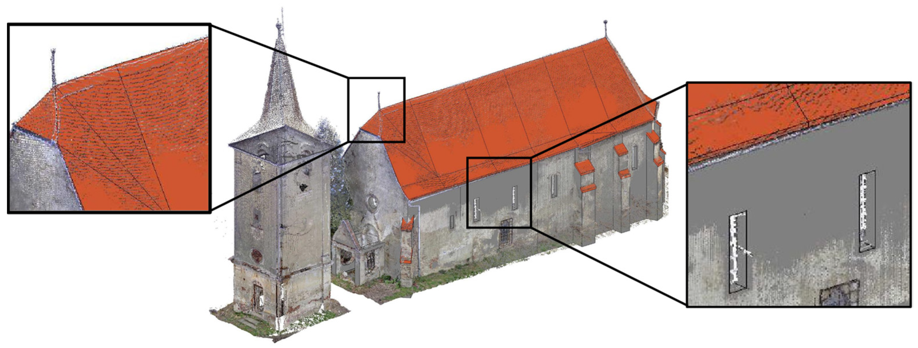
For the ECM use case, the analysis was performed on the full point cloud. Figure 6 presents several areas of interest for the structural assessment (the primary interest: safety concerns).
In the following step, to support the STR-use case, the original point cloud was decimated to 50 × 50 and imported into an BIM modelling tool for subsequent processing. Figure 7 showcases the process of transforming a point cloud into a 3D model. While the model still requires some refinement based on the cloud-to-model differences, it provides a good starting point for further detailing and analysis. To improve the 3D model, further manual refinement can be employed, but is usually labor-intensive, time-consuming, and requires specialized skills, while the added value is limited. It is true that the quality of the final model relies on the quality of the acquired point cloud data, a simplified 3D model that can be augmented with pictures, documents, and other types of meta information. In alignment with openBIM® specifications, the model can be exported to the Industry Foundations Classes (IFC) format and subsequently imported in a variety of BIM-capable tools for further uses (e.g., visualization, solution exploration, cost analysis, etc.).
Following a detailed initial structural assessment by qualified professionals (i.e., technical expertise based on visual information and material testing), structural analysis software is used to evaluate various intervention solutions tailored to the specific conservation needs of the cultural heritage asset. While these software programs typically use proprietary file formats, many offer the ability to import geometry from a BIM model using the IFC format. This shared geometry ensures that all project models (architectural, analytical, construction, and operational) are based on the same information, fostering seamless collaboration and data consistency. This collaboration allows data to flow between the BIM model and the structural analysis software, ensuring that all parties involved work with the latest and most accurate information.
4.3. The Neolithic Parța Sanctuary
4.3.1. Brief History of the Archaeological Site
The Neolithic sanctuary of Parța refers to an excavated Neolithic cult center or shrine located on the right bank of the Timiș River in Parța, south of Timișoara, Romania. According to archaeological discoveries and carbon dating, it was established that the site is a part of the Banat culture [28]. It is part of a larger complex of buildings and domestic settlements [29]. The sanctuary is a rectangular structure measuring 11.6 m in length and 6 m in width. It is partitioned into two separate rooms, with room A situated towards the east and room B positioned on the western side of the sanctuary.
4.3.2. Semi-Automatic 3D Point Cloud to Mesh Process
Automatically reconstructing a surface mesh from a 3D point cloud is a challenging and ill-defined problem (i.e., many solutions for the same input). The process of transforming a 3D point cloud (i.e., a discrete representation of the external objects’ surface) into a surface mesh that defines the shape of an object in 3D space involves several steps and can be performed using different algorithms (e.g., Ball Pivoting, Poisson Surface Reconstruction, Alpha Shape, Advancing Front Surface Reconstruction, etc.).
The Ball Pivoting Algorithm (BPA) is a method used for reconstructing a mesh from a 3D point cloud. This algorithm, introduced by Bernardini [30], is particularly popular due to its simplicity and effectiveness in generating meshes from sets of unorganized points. The basic idea behind BPA revolves around rolling a virtual ball of a predefined radius over the points to identify connections between them, forming triangles that eventually constitute the mesh. The algorithm starts by selecting a point from the cloud and looking for two nearest neighbors that can form a triangle with the ball touching these three points without enclosing any other points within. The ball then pivots around an edge of the triangle, looking for another point in the cloud that can form a new triangle with the pivot edge. When a suitable point is found, a new triangle is created between the pivot edge and this new point and then is added to the mesh. The algorithm continues to pivot the ball around the edges of the newly formed triangles, adding more triangles to the mesh. The algorithm ensures that the ball does not intersect with any existing points in the cloud other than the vertices of the forming triangle. If the algorithm encounters gaps or areas where the predefined ball radius does not fit (either too large to find another point or too small, enclosing other points), it can adjust the radius. The process continues until there are no more edges where the ball can pivot to form new triangles or when all points in the cloud are sufficiently close to the surface of the mesh, indicating that the mesh reconstruction is complete.
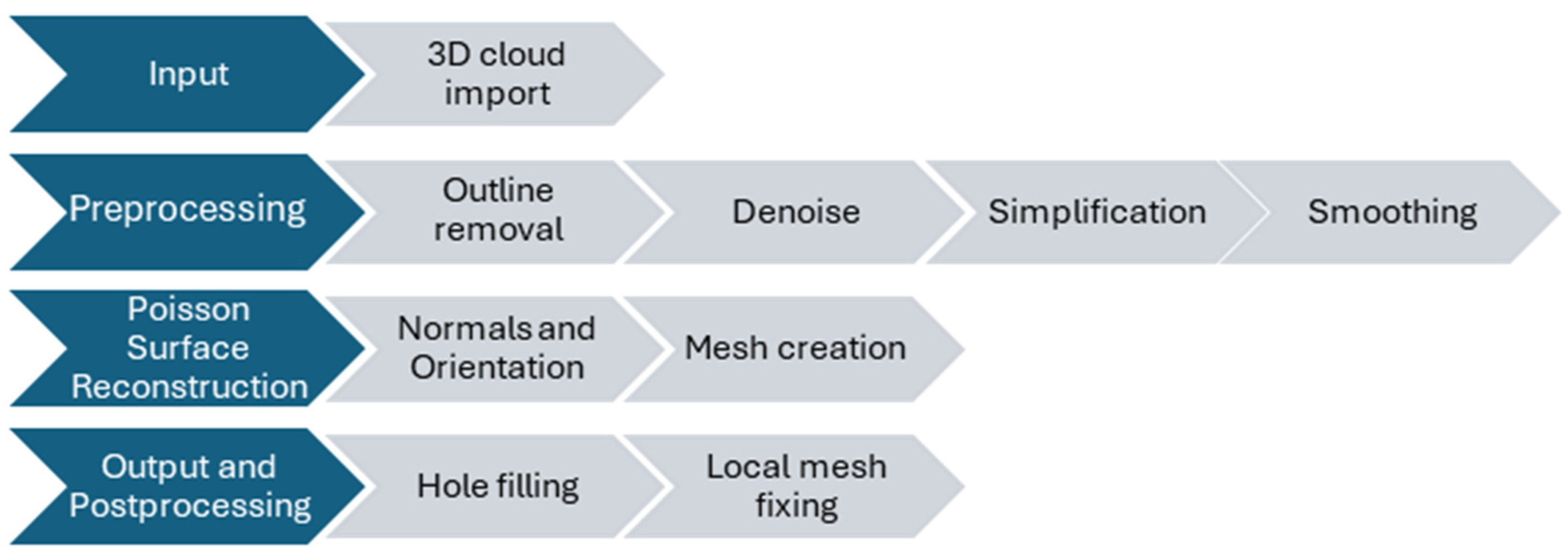
The Poisson Surface Reconstruction (PSR) algorithm is another popular method for reconstructing a 3D surface from a point cloud. Introduced by Michael Kazhdan and colleagues [31], it is especially noted for its ability to handle noisy data and produce smooth, high-quality surfaces. Unlike methods that directly triangulate the point cloud’s surface, such as the BPA, PSR works by solving a mathematical problem known as the Poisson equation. For PSR to work, each point in the cloud must have a normal vector associated with it, representing the outward direction of the surface at that point. In a first step, the algorithm ensures that the normals are consistently oriented across the cloud (crucial for the reconstruction process). Next, the PSR algorithm transforms the problem of surface reconstruction into solving a Poisson equation by creating an implicit function that describes the surface geometry. The gradient of this function at any point in space is aimed to align with the normal vectors of the closest points in the cloud. The solution to this equation is an indicator function whose value changes sharply at the boundary between the object and the surrounding space. Solving the Poisson equation results in a sparse linear system, constructed such that its solution approximates the indicator function, where the gradients best match the oriented point normals. To manage the computational complexity, the space containing the point cloud is often subdivided into an octree, allowing the algorithm to adaptively sample the implicit function at different resolutions, concentrating computational resources where the surface detail is most complex. Once the equation is solved, the iso-surface is extracted from the scalar field (i.e., the indicator function) that represents the boundary between the object and empty space. This is typically executed using a method like Marching Cubes, which generates a mesh by placing vertices and edges at points where the scalar field’s value crosses a certain threshold (often zero). Finally, any gaps in the mesh can be filled, and smoothing algorithms can be applied to refine the surface and remove artifacts from the reconstruction process.
The Alpha Shape method generalizes the concept of the convex hull and is particularly effective in capturing the shape of a set of points in space, allowing for the reconstruction of both the outer surface and the internal structure, depending on the chosen parameter. The method is based on the Delaunay triangulation of the points and involves the removal of certain simplices based on a parameter α, which controls the level of detail of the resulting shape. The α parameter defines a sphere of radius √α that is used to test the simplices (i.e., edges, triangles, and tetrahedra) in the triangulation. The choice of α is crucial since a small α might result in a more detailed shape that captures finer features, while a large α tends to produce a coarser shape that might include larger voids or ignore smaller details. For each simplex in the Delaunay triangulation, a sphere of radius √α is placed on its facets (for tetrahedra, on each triangular facet). If the sphere does not contain any points from the point cloud in its interior (for the given α), the simplex is considered part of the alpha shape. In 3D, this process results in selecting those tetrahedra (and their faces, edges, and vertices) that meet the criterion, effectively filtering out parts of the triangulation that do not contribute to the desired level of detail. The retained simplices form the alpha shape, which can be a collection of connected components, holes, and cavities, depending on the distribution of points and the choice of α. The edges and vertices of these simplices constitute the mesh representing the shape of the point cloud.
Advancing Front Surface Reconstruction (AFSR), unlike algorithms that rely on global properties (like the Poisson Surface Reconstruction), works in a more localized manner, progressively creating the mesh one element at a time. This approach is particularly effective in dealing with complex geometries and varying point densities, making it suitable for a wide range of applications, including the digitization of objects and environments in 3D scanning projects. The input for AFSR is a 3D point cloud that was initially preprocessed (i.e., denoises and with normals provided). The process begins by selecting a starting point or a small group of points from the point cloud and forming an initial tetrahedron that acts as the seed for the meshing process. This initial facet is chosen based on the density, curvature, or user input. The algorithm then iteratively selects a face from the front and attempts to create a new tetrahedron by connecting it with one or more points from the point cloud. The criteria for selecting the next point include proximity to the front, angle criteria to ensure smoothness, and possibly the fit to local surface features. Once a new element is added, the front is updated by removing the base face and adding the new faces of the created element. This process repeats, with the front advancing into the unmeshed regions of the point cloud. The algorithm continues to advance the front until the entire point cloud is covered or no suitable points can be found to form new elements without violating the meshing criteria. After the initial mesh is created, it may undergo refinement processes to improve quality, such as edge swapping, vertex relocation, or subdivision, to better capture the underlying geometry of the point cloud.
The Point2Mesh [32] method distinguishes itself by not relying on an explicitly defined prior that outlines expected shape characteristics. Instead, it utilizes what is termed a self-prior, automatically derived from the input point cloud itself. The self-prior captures the geometric repetitions inherent in a single shape through the weights of a deep neural network. The process involves adjusting the network’s weights to mold an initial mesh so that it shrink-wraps onto the input point cloud. This approach uniquely accounts for the entire shape being reconstructed by calculating shared local kernels to align with the global object form. In contrast to other reconstruction methods, which often struggle with the non-ideal conditions commonly found in real-world scans, this approach demonstrates that using a self-prior to closely fit a mesh around a point cloud achieves better results, thus avoids the pitfalls of traditional smoothness priors that can lead to suboptimal solutions by getting trapped in local minima.
In this instance, PSR was selected for its robustness, its capacity to preserve details, and its effectiveness in managing noisy datasets. Figure 8 outlines the mesh creation process.
Its proficiency in accurately reconstructing surfaces characterized by complex shapes and intricate details made it exceptionally well-suited for the designs and textures it encountered. It combines technological precision with practical applicability, ensuring that heritage assets are well-documented, preserved, and ready for both current needs and future research.
Figure 9 shows the point cloud and the subsequent mesh created for visualization with a detail, for comparison.
The transformation from point cloud to mesh model results in a continuous model that goes to define the surfaces of objects and structures; indeed, as shown in Figure 9, it is possible to obtain a useful model for the next stage of augmented reality model construction.
4.3.3. From BIM for AR Application
The project’s digitalization was confined to creating a scaled digital reconstruction of the actual site, incorporating historical and archaeological data, leading to a BIM application focused exclusively on Visualization-Use Case (VIZ) and data consolidation purposes. Despite the absence of specific conservation requirements, with the model itself being a scaled reconstruction, an intelligent model was developed to integrate and consolidate historical information, including reports, photographs, historical records, and archaeological findings, within the BIM framework. This enriched model serves not only as a visual tool but also as a comprehensive repository of the site’s historical context, offering a multidimensional perspective that enhances understanding and appreciation of its heritage. By leveraging advanced digital tools, this approach facilitates informed decision-making in future conservation efforts, while providing a valuable educational and research resource that captures the essence of the site’s historical and cultural significance.
Artivive [33] is an application that allows users to create and experience augmented reality (AR) artworks, overlaying digital content on top of the real world, creating a new dimension. For archeological applications, it can be used to reconstruct the original appearance of ancient artifacts, buildings, or landscapes that have been damaged or eroded over time. By scanning the physical remains with Artivive, the user can see what they looked like in the past, with realistic details and animations. This can enhance the understanding and appreciation of historical and cultural heritage. It can also enable visitors to visualize the historical context and significance of archeological findings. Figure 10 presents the end results for the visualization BIM-use case.
By scanning the objects with Artivive, the user can access additional information, such as the origin, function, meaning, or symbolism of the artifacts. This can provide a deeper insight into the lives and cultures of the people who created or used them. Furthermore, it can be employed to create interactive and immersive exhibitions that showcase archeological discoveries. By using Artivive, the user can experience the archeological sites or objects in a new and engaging way, with sound, narration, or interactivity. This can attract more visitors and increase their interest and enjoyment of archeology.
5. Concluding Remarks
This research investigated the integration of Building Information Modeling (BIM) processes into cultural heritage conservation, exploring its benefits for both engineering and conservation purposes, as well as for enhanced visualization. The results obtained and shown in the case studies highlight the potential of BIM as a powerful tool for safeguarding and disseminating cultural heritage, offering two distinct yet complementary directions:
- BIM for Engineering and Conservation, focusing on precise documentation and analysis enabled by BIM processes for the creation of comprehensive and accurate 3D models, meticulously capturing the geometry, materials, and historical details of heritage assets. This enables detailed analysis of structural integrity, decay patterns, and conservation needs, supporting informed decision-making and ensuring that interventions respect historical authenticity. Furthermore, BIM promotes collaboration between diverse stakeholders involved in conservation projects, including architects, engineers, conservators, archaeologists, and contractors, sharing information to streamline workflows and minimize communication gaps.
- Enhanced Model for Visualization, Gaming, and Virtual Tours; focusing on accessibility and public engagement, immersive virtual tours, and interactive gaming experiences. This direction fosters an accessible and engaging platform for public education and outreach, encouraging wider appreciation and connection with cultural heritage. In addition, high-fidelity digital replicas created through 3D scanning capture the intricate details of a heritage asset, offering a valuable preservation tool. This digital archive ensures that the legacy of the asset continues even if the physical structure faces challenges.
Leveraging BIM processes for both engineering and conservation needs ensures the physical preservation of assets, while the development of enhanced models fosters public engagement and understanding. By embracing this multifaceted approach, we can safeguard our cultural heritage for future generations while fostering a deeper appreciation for its enduring value and diverse narratives.
Author Contributions
Conceptualization: A.C., M.P., D.C. and S.H.; Methodology: A.C., M.P., D.C. and S.H.; Software: A.C., M.P. D.C. and S.H.; Formal Analysis: A.C., M.P., D.C. and S.H.; Investigation: A.C., M.P., D.C. and S.H.; Writing original draft: A.C., M.P., D.C. and S.H.: Visualization: A.C., M.P., D.C. and S.H. All authors have read and agreed to the published version of the manuscript.
Funding
This research received no external funding.
Data Availability Statement
Data is not freely available. Please contact the corresponding author for further information.
Conflicts of Interest
The authors declare no conflict of interest.
References
- Veillon, R.; UNESCO World Heritage Centre. State of Conservation of World Heritage Properties—A Statistical Analysis (1979–2013). 2014. Available online: http://whc.unesco.org (accessed on 10 February 2024).
- ICOMOS. Annual Report 2019; ICOMOS: Sydney, NSW, Australia, 2020. [Google Scholar]
- World Heritage Convention. Policy Document for the Integration of a Sustainable Development Perspective into the Processes of the World Heritage Convention. 2015. Available online: http://whc.unesco.org/en/documents/1334 (accessed on 10 February 2024).
- Wong, F.; Chiong, E. The Importance in Preserving Our Cultural Heritage. Bus. Today. 2022. Available online: https://www.businesstoday.com.my/2022/03/12/93591/ (accessed on 10 February 2024).
- Chatzistamatis, S.; Tsekouras, G.E.; Anagnostopoulos, C.-N. The Quality in 3D Acquisition of Cultural Heritage Assets: Challenges and Risks. In 3D Research Challenges in Cultural Heritage III: Complexity and Quality; Digitisation, M.I., Patias, P., Eds.; Springer International Publishing: Cham, Switzerland, 2023; pp. 65–76. [Google Scholar] [CrossRef]
- Kantaros, A.; Ganetsos, T.; Petrescu, F.I.T. Three-Dimensional Printing and 3D Scanning: Emerging Technologies Exhibiting High Potential in the Field of Cultural Heritage. Appl. Sci. 2023, 13, 4777. [Google Scholar] [CrossRef]
- Gajski, D.; Župan, R.; Racetin, I.; Krstić, R. Straightforward Stereoscopic Techniques for Archaeometric Interpretation of Archeological Artifacts. Heritage 2023, 6, 5066–5081. [Google Scholar] [CrossRef]
- Skublewska-Paszkowska, M.; Milosz, M.; Powroznik, P.; Lukasik, E. 3D technologies for intangible cultural heritage preservation—Literature review for selected databases. Herit. Sci. 2022, 10, 3. [Google Scholar] [CrossRef]
- buildingSmart. OpenBIM. Available online: https://www.buildingsmart.org/about/openbim/ (accessed on 10 February 2024).
- Delpozzo, E.; Balletti, C. Bridging the gap: An open-source gis+bim system for archaeological data. The case study of Altinum, Italy. Int. Arch. Photogramm. Remote Sens. Spat. Inf. Sci. 2023, 48, 491–498. [Google Scholar] [CrossRef]
- Lovell, L.J.; Davies, R.J.; Hunt, D.V.L. The Application of Historic Building Information Modelling (HBIM) to Cultural Heritage: A Review. Heritage 2023, 6, 6691–6717. [Google Scholar] [CrossRef]
- Antonopoulou, S.; Bryan, P. BIM for Heritage: Developing a Historic Building Information Model. 2017. Available online: https://historicengland.org.uk/advice/technical-advice/recording-heritage/ (accessed on 10 February 2024).
- Bryan, P.; Joanna, H. BIM for Heritage—Developing the Asset Information Model. 2019. Available online: https://historicengland.org.uk/images-books/publications/bim-for-heritage-aim/ (accessed on 10 February 2024).
- Historic England. Organisational Information Requirements (OIR)—Heritage (HIR_OIR_V1); Historic England: Swindon, UK, 2019.
- Historic England. Asset Information Requirements (AIR)—Heritage (HIR_AIR_V1); Historic England: Swindon, UK, 2019.
- Historic England. Exchange Information Requirements (EIR)—Heritage (HIR_EIR_V1); Historic England: Swindon, UK, 2019.
- Boardman, C.; Bryan, P. 3D Laser Scanning for Heritage Advice and Guidance on the Use of Laser Scanning in Archaeology and Architecture; Historic England: Swindon, UK, 2018.
- Bedford, J. Photogrammetric Applications for Cultural Heritage. Guidance for Good Practice; Historic England: Swindon, UK, 2017.
- Creating Virtual Guide with RC. Available online: https://www.capturingreality.com/Virtual-Guide-with-RealityCapture (accessed on 10 February 2024).
- Pepe, M.; Alfio, V.S.; Costantino, D.; Herban, S. Rapid and Accurate Production of 3D Point Cloud via Latest-Generation Sensors in the Field of Cultural Heritage: A Comparison between SLAM and Spherical Videogrammetry. Heritage 2022, 5, 1910–1928. [Google Scholar] [CrossRef]
- Melendez, S. How Digital Modeling Plays a Key Role in Restoring the Notre Dame Cathedral. Available online: https://www.fastcompany.com/90881189/digital-modeling-restoring-notre-dame-cathedral (accessed on 10 February 2024).
- Oostwegel, L.J.N.; Jaud, Š.; Muhič, S.; Malovrh, R.K. Digitalization of culturally significant buildings: Ensuring high-quality data exchanges in the heritage domain using OpenBIM. Herit. Sci. 2022, 10, 10. [Google Scholar] [CrossRef]
- Ferreira, T.M.; Romão, X.; Lourenço, P.B.; Paupério, E.; Martins, N. Risk and Resilience in Practice: Cultural Heritage Buildings. Int. J. Archit. Herit. 2021, 15, 973–975. [Google Scholar] [CrossRef]
- Vidovszky, I.; Pintér, F. IoT System for Maintenance Monitoring of Historic Buildings—Smart Monitoring. IOP Conf. Ser. Mater. Sci. Eng. 2022, 1218, 012007. [Google Scholar] [CrossRef]
- González, E.M.A.; Municio, M.; Alemán, N.; Marquez, B.J.M. Cultural Heritage and Internet of Things. In Proceedings of the 6th EAI International Conference on Smart Objects and Technologies for Social Good, Aveiro, Portugal, 14–16 September 2020; pp. 248–251. [Google Scholar] [CrossRef]
- Verdesoto, I.; Fernández, N.Á.; Beltrán-Roca, P.J.; García-Diego, F.J. Preventive Conservation of a Short Theatre Skit (Valencian ‘Sainete’) with Cloud Data Storage and Internet of Things. Sensors 2023, 23, 9790. [Google Scholar] [CrossRef] [PubMed]
- BuildingSmart. Building Information Modeling Use Case Documentation v.4.1. Available online: https://www.buildingsmart.org/wp-content/uploads/2019/02/bSI-Awards-2019-Use-Case-Documentation-V4-1.xlsx (accessed on 11 February 2024).
- Frincu, M. Was the Parta Neolithic Sanctuary in Romania Astronomically Aligned? Mediterr. Archaeol. Archaeom. (MAA) 2018, 18, 43. [Google Scholar]
- Gimbutas, M. The Goddesses and Gods of Old Europe, 6500–3500 B.C.: Myths and Cult Images, 1st ed.; University of California Press: Berkeley, CA, USA, 2007. [Google Scholar]
- Bernardini, F.; Mittleman, J.; Rushmeier, H.; Silva, C.Â.; Taubin, G.; Member, S. The Ball-Pivoting Algorithm for Surface Reconstruction. IEEE Trans. Vis. Comput. Graph 1999, 5, 349–359. [Google Scholar] [CrossRef]
- Kazhdan, M.; Bolitho, M.; Hoppe, H. Poisson Surface Reconstruction. In Proceedings of the Fourth Eurographics Symposium on Geometry Processing, Cagliari, Italy, 26–28 June 2006. [Google Scholar]
- Hanocka, R.; Metzer, G.; Giryes, R.; Cohen-Or, D. Point2Mesh: A Self-Prior for Deformable Meshes. ACM Trans. Graph 2020, 39, 4. [Google Scholar] [CrossRef]
- ARTIVIVE. Available online: https://press.artivive.com/ (accessed on 23 February 2024).
Figure 1.
Information requirements and information models.

Figure 2.
Examples of 3D model building from laser scanning (left) and photogrammetry (right) (author-generated figures).
Figure 2.
Examples of 3D model building from laser scanning (left) and photogrammetry (right) (author-generated figures).

Figure 3.
Laser and photogrammetry used together for increased accuracy and precision [19].
Figure 3.
Laser and photogrammetry used together for increased accuracy and precision [19].

Figure 4.
Location of the sites taken into consideration on Google Earth platform.

Figure 5.
Scanning positions and resulting registered point cloud (cropped to location).

Figure 6.
Existing condition modeling for current condition assessment and structural measurements.

Figure 7.
3D model employed for subsequent engineering analyses (e.g., structural analysis).

Figure 8.
Poisson Surface Reconstruction process.

Figure 9.
3D point cloud (left) and watertight mesh (right).

Figure 10.
Three-dimensional modeling visualization.


Table 1.
Technical requirements for data gathering.
| Area | Scanning Accuracy | Photogrammetry Data | Historic Data | Conservation Data |
|---|---|---|---|---|
| Building Envelope and Structural Integrity | High accuracy (preferably sub-millimeter) for precise crack measurements. | High-resolution images for textures, surface conditions, and potential damage (weathering, erosion). | Construction drawings, plans, and reports documenting original design, materials, and past interventions. | Records of previous restoration, material analyses, and structural assessments. |
| Architectural Details and Decorative Elements | High accuracy (1–3 mm) for capturing carvings, moldings, and ornamentation. | Very high-resolution images for preserving color palettes, textures, and fine details. | Color architectural drawings, photographs, and descriptions of decorative elements and their symbolism. | Reports on past restoration techniques, paint analyses, and recommendations for material compatibility. |
| Archaeological and Historical Features | Variable depending on feature size and significance. High accuracy for smaller artifacts, lower accuracy for larger structures. | High-resolution images capturing details, colors, and textures of artifacts and features. | Archaeological reports, historical documents, and maps pertaining to the site’s history and context. | Records of past archaeological excavations, conservation treatments, and material analyses. |
| Building Systems and Utilities | Moderate accuracy (3–5 mm) for documenting existing systems and potential replacements. | Images capturing locations and condition of existing utilities and equipment. | Documentation of original building systems, blueprints, and maintenance records. | Assessments of system integrity, reports on past repairs, and recommendations for upgrades compatible with historical character. |
Disclaimer/Publisher’s Note: The statements, opinions and data contained in all publications are solely those of the individual author(s) and contributor(s) and not of MDPI and/or the editor(s). MDPI and/or the editor(s) disclaim responsibility for any injury to people or property resulting from any ideas, methods, instructions or products referred to in the content. |
© 2024 by the authors. Licensee MDPI, Basel, Switzerland. This article is an open access article distributed under the terms and conditions of the Creative Commons Attribution (CC BY) license (https://creativecommons.org/licenses/by/4.0/).
Share and Cite
MDPI and ACS Style
Crisan, A.; Pepe, M.; Costantino, D.; Herban, S. From 3D Point Cloud to an Intelligent Model Set for Cultural Heritage Conservation. Heritage 2024, 7, 1419-1437. https://0-doi-org.brum.beds.ac.uk/10.3390/heritage7030068
AMA Style
Crisan A, Pepe M, Costantino D, Herban S. From 3D Point Cloud to an Intelligent Model Set for Cultural Heritage Conservation. Heritage. 2024; 7(3):1419-1437. https://0-doi-org.brum.beds.ac.uk/10.3390/heritage7030068
Chicago/Turabian StyleCrisan, Andrei, Massimiliano Pepe, Domenica Costantino, and Sorin Herban. 2024. "From 3D Point Cloud to an Intelligent Model Set for Cultural Heritage Conservation" Heritage 7, no. 3: 1419-1437. https://0-doi-org.brum.beds.ac.uk/10.3390/heritage7030068