2. Tsunamigenic Sources in the Greek Region
In the Mediterranean and the connected seas, the tsunamigenic sources are distributed along certain zones ([
23],
Figure 2), which are controlled by the geodynamic setting and the geological features of the region. The highest tsunami potential is concentrated in the zones of the western and eastern Hellenic arc, numbered 9 and 10, respectively, i.e., along the active Hellenic Subduction Zone, where very large tsunamigenic earthquakes occurred in the past.
Of high tsunami potential is also the Corinth Gulf, zone 12 in Central Greece. The Corinth Gulf is a rapidly opening continental rift due to the N–S extensional field that tectonically dominates the area. The result of this process is a high seismicity rate, with the earthquakes taking place mainly along active fault zones trending about E–W. The tsunami rate in this zone is the highest in the entire region due to combined favoring factors, such as the high seismicity, the susceptibility to coastal and submarine landslides as well as the steep bathymetry. However, the tsunamis produced within the Corinth Gulf are local, frequently powerful, but incapable of propagating beyond the closed Gulf.
In the north Aegean Sea, the tsunami potential is low since the active tectonics of the area are characterized by strike-slip faults. Of particular interest is the area of the central Ionian Sea (IS), which is geographically situated between the tsunamigenic zones 8 and 9. In the map of
Figure 2, the IS area is not categorized as a tsunamigenic zone. The reason is that no tsunami generation is known in the area, although it is characterized by very high seismicity. For example, in August 1953, a series of very strong earthquakes isolated the islands of Cephalonia, Ithaki, and Zakynthos and caused the worst seismic destruction in the modern history of Greece. Such earthquakes struck the area in previous centuries as well. The new observations collected and documented in this paper reveal that during the seismic crisis of 1953, local but powerful tsunamis were generated.
3. Materials and Methods
3.1. Method Outline
The aim of collecting new observational material is to document tsunamis that occurred in the region of Greece and surrounding areas from 1900 to 2023. Emphasis has been given to tsunamis that remained unknown to the tsunami community. Material is also provided for some tsunamis that are little-known in the sense that they have been included in earlier tsunami studies but their documentation either is incomplete or has not been published so far. Three out of 26 individual events examined refer to already known seismic tsunamis: (a) 8 November 1905 in Mt. Athos, northwestern Aegean Sea, (b) 9 February 1948 in Karpathos Isl., southeastern Aegean Sea, and (c) 24 February 1981 in eastern Corinth Gulf. These tsunamis, which occurred in zones 15, 10, and 12, respectively (
Figure 2), have been included in the current investigation for three different reasons. The 1905 event has been included with the aim of attracting the interest of the reader to the cascade effect that characterized the event. Namely, the earthquake caused landslides and rock falls, which, after entering the seawater, triggered the tsunami. The 1948 tsunami remains controversial as regards its generation mechanism, i.e., seismic versus landslide. We present new eyewitness accounts as well as new observations collected during our field survey on the island of Karpathos. The new material collected may support future studies to better understand the tsunami generation mechanism. The small tsunami of 1981 was documented from eyewitness accounts as well as from a tide-gauge record. However, this record remains very little known since it was published in a local journal. Here, we reproduce the mareogram for the sake of the international tsunami community.
Following previous compilations of tsunami data, our investigation also included phenomena that likely have not been tsunamis but other kinds of sea disturbances, like seiches and seaquakes. Seiches are standing waves that are produced in narrow bays, usually by strong earthquakes. They are observed as rhythmic oscillations, which occasionally may cause minor damage. Seaquakes are seismic P-waves entering and traveling through the seawater layer after diffraction in the interface of the solid earth and the seawater layer. Seaquakes are usually felt onboard as sudden, strong push upwards and may cause damage to vessels.
In the next lines, we present tsunami observations collected for 26 individual events of sea disturbances reported in association with strong earthquakes. For each event, we evaluated its real tsunami nature and characterized it by a reliability index, R. We applied a 4-degree standard reliability scale by following previous groups of experts working since the 1990s for the compilation of the New European Tsunami Catalogue in the frame of EC-supported projects. The reliability scale ranges from 1 = improbable tsunami, 2 = questionable tsunami, 3 = probable tsunami, to 4 = definite tsunami. There are three main indicators for assigning a reliability index to a particular event: the credibility of the information source, the description of the phenomenon itself, and the number of individual information sources reporting the event. For events of R ≥ 2, we assigned tsunami intensity, K, in one or more observation points provided that appropriate data were available. The 12-grade Papadopoulos–Imamura tsunami intensity scale has been applied.
3.2. Tsunami Observations
The material compiled comes from official reports, local archives, books, press reports, eyewitness accounts, pictorial and video material, and tide-gauge records, as well as from our field surveys.
The “Annales de l’ Observatoire National d’ Athènes” has been one of the information sources used in this paper. This yearly publication of the National Observatory of Athens (NOA), which is not easily accessible, started at the end of the 19th century and continued up to the 1930s. Since then, it was renamed as “Bulletin of the National Observatory of Athens”. Another source that has been utilized only to a limited extent is the unpublished manuscript of NOA titled “Book of Earthquakes”. In this manuscript, earthquakes and associated phenomena have been compiled for the period from 1893 to 1915 based on macroscopic observations performed in several parts of Greece by local observers affiliated with the NOA.
The material collected is presented by following the chronological order of the events documented. The earthquake origin times and magnitudes are according to the determinations in the catalog by ISC-GEM [
2] unless otherwise reported. Earthquake magnitudes have been re-computed uniformly to a large extent before their inclusion in the ISC-GEM [
2] catalog. Magnitudes reported by [
2] have been reproduced in the present study without changes, e.g., with two decimal digits. As a rule, the uncertainty involved in the magnitudes calculated by [
2] is ±0.2 or ±0.1 for earthquakes occurring before or after 1965, respectively. On many occasions, we found it useful to reproduce extracts from relevant reports or statements without changes unless it was needed for a better understanding of a particular document. In such a case, our brief linguistic intervention is marked as [intervention]. For example, in the statement “The tsunami [of 1956] was observed in Scala beach”, the note [of 1956] has been added by us.
A valuable source of information for historical tsunamis is geological evidence, e.g., tsunami sediment deposits left behind by strong tsunamis. However, for tsunamis occurring in the modern period, which is examined in this paper, the preservation of geological evidence, if any, is very limited due to modern human interventions in coastal zones, e.g., tourist activities, which usually do not allow preservation of tsunami geological evidence. In addition, most of the tsunamis we studied have not been of so large a size as to leave behind geological traces. An exemption is a strong tsunami that occurred on 9 February 1948 in Karpathos Isl., SE Aegean Sea. However, during our field survey in Karpathos, we were unable to identify geological evidence for this tsunami.
3.2.1. Time Period 1900–1952
Chalkis, Central Greece, 11 April 1902 (R = 3, K = 3 in New Psara)
On 11 April 1902, 18:35 UTC, a strong earthquake of moment magnitude M
w5.7 (±0.2) [
24] ruptured near the city of Chalkis, Central Greece (
Figure 3). According to the
Book of Earthquakes [
25], the macroseismic intensity of degree V was assigned in the Rossi–Forel scale, which corresponds to intensity VI in the modified Mercalli–Sieberg scale (MMI) [
26]. In the same publication, it is noted that on the beach of the nearby New Psara village, “there was an effervescence of waves looking like a storm”. This event is published here for the first time, although it is not clear if it was a local tsunami or a standing wave in the bay.
Mt. Αthos, Northern Greece, 8 November 1905 (R = 4, K = 6 South Coast of Mt. Athos)
The large earthquake that ruptured offshore to the south of Mt. Athos, Greece, on 8 November 1905, has been listed in various earthquake catalogs, e.g., [
2,
24]. In a recent study, various documents were collected from local archives, and a macroseismic magnitude equivalent to M
w~7.2 was calculated [
27], which is equal to the instrumentally determined magnitude M
w7.24 [
2]. The information sources examined revealed for the first time [
27] that a local but powerful tsunami with a 3 m run-up was generated by earthquake-induced landslides that occurred on the southern slope of Athos Mountain (
Figure 3). Eleven persons were reportedly killed by the tsunami wave [
27]. This is a characteristic example of the cascade effect in which the earthquake triggered subaerial landslides, and the landslides caused the tsunami after entering the seawater.
Cephalonia Isl., Ionian Sea, Greece, 24 January 1912 (R = 4, K = 4 in Argostoli Bay)
Previous tsunami catalogs included limited information about anomalous sea level changes in association with this strong earthquake of M
w6.40. However, the documentation of the event is little known. Here, we present relevant details extracted from the original source [
28]. It has been reported that in Argostoli, the main town of Cephalonia (
Figure 3), a “…significant rise of the sea level was observed before the earthquake”. After the earthquake, “…initially the sea retreated, then it raised”. The engineer of a ship reported that “with the earthquake a big wave overtopped the bridge of the ship, which was sailing 20 km east of the epicenter about one mile offshore the village Pesades, Cephalonia Isl”.
Lefkada Isl., Ionian Sea, Greece, 27 November 1914 (R = 2, K = 3 in Nydri Village)
Although the local tsunami that followed this strong earthquake of M
w6.31 is included in previous catalogs, we provide the original information, which reads as follows [
29,
30]: “In Nydri village [east coast of Lefkada Isl.,
Figure 3] the pier detached and sunk at depth of 2.5 m. In the same village, a sea wave was generated, which according to estimations of local people was 2–3 m high”. This sea wave remains of questionable origin since it is not clear if the sea disturbance was a tsunami produced by the earthquake or by the pier detachment and sinking.
Ithaki Isl., Ionian Sea, Greece, Greece, 27 January 1915 (R = 1)
Sea waves were observed in Ithaki Isl. during this very strong earthquake (M
w6.46). Although the event is listed in one of the existing tsunami catalogs [
6], the exact description [
29] has not been provided so far. The description reads as follows: “…οn a observe durant le sisme que la mer était ondulée”, which reads as follows: “it was observed that during the earthquake the sea was wavy”. However, no additional information has been found. Possibly, standing waves were generated in Vathy Bay in the main village of the island (
Figure 3).
Lefkada Isl., Ionian Sea, Greece, 7 August 1915 (R = 2, K = 2 in Lefkada)
In previous catalogs, e.g., [
1,
6], we may find only a synoptic description of the tsunami phenomena associated with this very strong earthquake (M
w6.50). However, it is worth communicating the exact description included in [
30]: “Before the earthquake an oscillation of the sea was generated between the islands of Cephalonia and Lefkada [
Figure 3]. The result was that two waves were produced moving in opposite directions towards the two coasts”. This observation, however, does not explain how much time before the earthquake the sea oscillation occurred. The generation of two waves may indicate the reflection of an initial oscillation. However, the occurrence of the phenomenon before the earthquake is hardly explainable. We do not rule out that the sea oscillation occurred very soon after the earthquake, but the observer is confused about the exact time of this phenomenon.
Methana, Central Greece, 8 August 1922 (R = 3, K = 2 in Methana)
An earthquake of M
w5.88 (
Figure 3; epicenter taken from the earthquake catalog of the Aristotelian University of Thessaloniki, (
http://geophysics.geo.auth.gr/ss/, accessed on 15 December 2023) which occurred near the volcanic area of Methana, northeastern side of Peloponnese, Central Greece, triggered a small tsunami. According to an official report [
31], “a small rise of the sea level was observed [after the earthquake] in Methana town”.
Chalkidiki, Northern Greece, 5 December 1923 (R = 2, K = 2 in Kassandra)
Extensive damage was caused in many villages by the strong earthquake (M
w6.39) that violently shook the area of Kassandra, Chalkidiki Peninsula (
Figure 3), on 5 December 1923 at 20:56:49 UTC. Previous authors [
32,
33] were informed by local people that a sea wave was observed on the coasts of Kassandra after the earthquake. However, no further information was found about this little-known event.
Kos Isl., Dodecanese, Greece, 23 April 1933 (R = 1)
At 05:57:37 UTC of 23 April 1933, the island of Kos, situated in the Dodecanese Island complex, southeastern Aegean Sea, Greece (
Figure 3), was hit by a strong earthquake (M
w6.43) that isolated Kos, the main city of the island, leaving behind 181 human victims [
34]. According to a newspaper report (“ΠAΤΡΙΣ”, PATRIS, 1933), an ebb happened along the coast of Kos port for a length of several tens of meters. The examination of this report, other documents, and eyewitness accounts showed that the rough sea that followed the earthquake was due rather to stormy weather than to tsunami waves [
34]. In a non-reviewed article of popular science [
35], it has been supported that about 15–20 min after the earthquake, a tsunami of 2–3 m in height attacked the entire coastal zone of Kos city for an estimated length of 4–5 km. In the Marmari locality, the water inundated the coast and advanced 200 m inland. The same author added that local people collected dead fish left behind by the wave. However, the information published by [
35] has not been authenticated.
Vassilikon, Central Greece, 20 July 1938 (R = 4, K = 3 in Vassilikon)
A destructive earthquake of magnitude M
w6.10 occurred near Oropos, Central Greece (
Figure 3; epicenter taken from (
http://geophysics.geo.auth.gr/ss/, last access on 15 December 2023) on 20 July 1938 at 00:23:35 UTC. According to an official internal report of the National Observatory of Athens [
36], eyewitnesses reported that on the beach of Vassilikon village (
Figure 3), western Evia Isl., “a sea motion that looked like of boiling water was observed”. According to a press correspondence (“AΚΡOΠOΛΙΣ”, AKROPOLIS, 28 July 1938), “in the Evripus strait [close to Vassilikon] the sea was agitated at the earthquake time, while next morning dead fish were floating along the beach”. This event has not been included in previous catalogs.
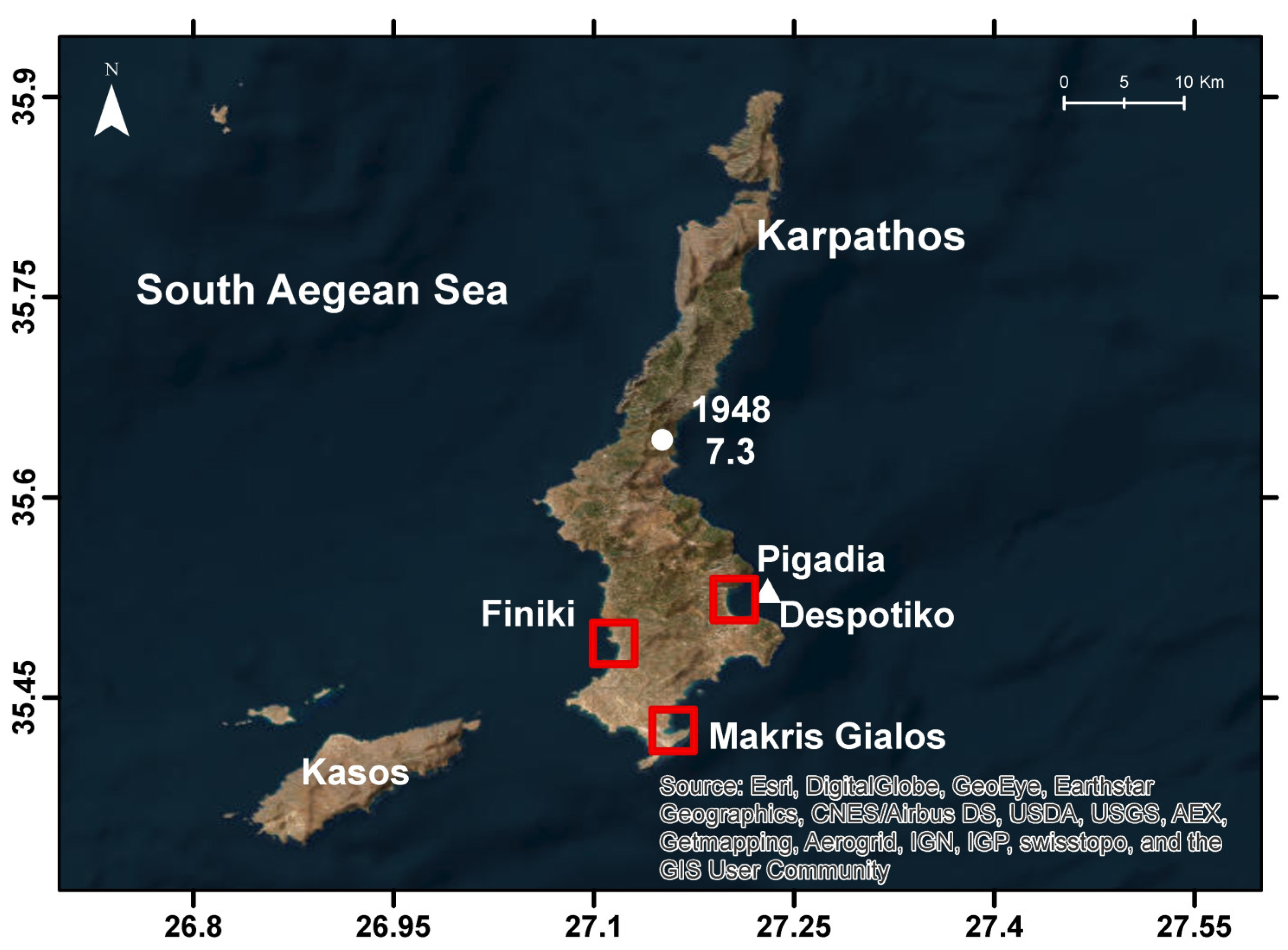
Karpathos Isl., Dodecanese, Greece, 9 February 1948 (R = 4, K = 9 in Pigadia; R = 3, K = 4 in Makris Gialos)
On 9 February 1948, at 12:58:13 UTC (14:58:13 local time), a very strong earthquake measuring magnitude M
w7.30 hit the island of Karpathos situated in the Dodecanese Island complex, southeastern Aegean Sea, Greece (
Figure 3). Extensive damage was caused to many houses and other buildings in Pigadia, the main town of the island (
Figure 4), as well as in other villages. Soon after the earthquake, a strong tsunami followed. Papadopoulos et al. (2007) [
37] reviewed previous publications, interviewed eyewitnesses, and performed a field survey on the island. The estimated maximum wave height was ~2.5 m in Pigadia. The same authors added that “It was said that tsunami inundation was observed in Finiki, a small fish village in the SW side of Karpathos [
Figure 4]”. Obviously, the tsunami observation in Finiki was not confirmed: “it was said”. However, the relevant statement was erroneously rephrased by other authors [
38] as “Papadopoulos et al. (2007) report that the 1948 tsunami was also observed at Finiki”.
Ebeling et al. (2012) [
38] also performed field observations in Karpathos and, based on eyewitness accounts, estimated wave heights up to ~7.3 m in Pigadia Bay. Their simulation experiments for seismic sources underestimated the reported wave heights by an order of magnitude. A hypothetical landslide source with appropriately selected features better reproduced the observed heights.
Here, we complete the observational material for this important tsunami with a collection of additional tsunami accounts and new observations collected during a field trip in Karpathos. The first account comes from the book of a local author [
39] who was an elementary school student at the earthquake time. We met the author in Pigadia town on 15 September 2020. He verified that his tsunami narration is true and faithful. His narration reads as follows: “[After the earthquake] in the port of Pigadia the sea receded, and the people saw boats lying on the bottom and fish sparring out of the water. The bases of the rock islets Garonitso and Despotiko appeared [
Figure 4], and the two islets looked like mushrooms since their bases were eroded by the waves over the centuries”. It is evident that this is not due to sea bottom uplift but to the seawater retreat. Unfortunately, no pictures are available, but a similar case observed after the Samos 30 October 2020 tsunami is illustrated in
Figure 5. We estimated that the sea retreat happened for ~650 m. The narration continues as follows: “Soon after the 2–3 m high tidal wave returned violently from the open sea and broke up all the boats. On the ground floor of those houses which were situated near the coast nothing was left standing. Oil containers were broken, and many other objects destroyed. In houses with front doors and basement shutters opening inward, the damage was incredibly extensive. In those opening in the opposite direction, i.e., outwards, the resistance of the doors or windows limited the damage. In ‘Sintrivani’ [a fountain situated uphill in the town] the wave rose up to 6 m and left behind trunks and broken boats while crates washed away from customs warehouses. In the site ‘Ryaki’, to the west of Pigadia, the wave flowed behind the Filippidis bridge and reached up near the Forest Department where it left seaweed and dead fish about 120 m inland. In the area of ‘Afoti’ local river [west of Pigadia], the wave washed away and left sables and other fish on the myrtle and sphagnum as far as the oil workshop of Sarris, a kilometer inland away from the sea. The same happened along the sea front from Tampatsia up to Vronti [in Pigadia Bay]”.
A journalistic article about the earthquake and tsunami in Karpathos [
40] (see link in the
Supplementary Materials) referred to an account by the eyewitness Mr. Vaggelis Papadopoulos, 13 years old at the earthquake time: “[Ιn the port of Pigadia] the sea receded three times up to the islet Despotiko [
Figure 4] and each time returned and engulfed everything. The tsunami inundated Pigadia at a long distance inland leaving behind fish and broken small vessels. Large containers of oil were swept away. People run in the fields to collect fish”. The same article also included the account of the eyewitness, Mr. Michalis Fragos, who was an elementary school student at the time. His narration says: “After the earthquake and the tsunami inundation I walked along the streets of Pigadia and saw broken boats and fish that had come out and were floundering on the οlive trees which had drowned by the salt”. No fatalities were officially reported by the earthquake and the tsunami, but according to rumors, an old lady drowned in a coffee shop basement [
40]. From another article [
41] (see link in the
Supplementary Materials), we learn that in Pigadia, the cathedral of Evaggelistria (Holy Mother), situated close to the coast, was damaged by both the earthquake and the tsunami and, therefore, it was decided to demolish.
A new tsunami observation point was revealed during the field trip we carried out along with other scientists (see Acknowledgements) on 14 September 2020, in the Afiarti area, near the airport (
Figure 4 and
Figure 6), southeastern side of Karpathos. A local citizen, Mr. Ilias Spanos, 75, narrated what he heard from the elder people of the village: “Soon after the earthquake several eyewitnesses saw the sea receding in Makris Gialos bay [
Figure 4 and
Figure 6] and a boat tied there sitting on the bottom. The sea returned and inundated inland at distance of ~150 m [
Figure 6]. When the sea receded, people ran to gather fish left ashore”. From this narration it comes out that the wave reached the southern side of the today existing airport area of the island. We estimated that the wave run-up at that point has been ~2.0–2.5 m.
3.2.2. Ionian Sea Earthquake Sequence, 9–12 August 1953
A sequence of very strong earthquakes ruptured the area of central Ionian Sea islands (
Figure 7) from 9 to 12 August 1953. The first earthquake measuring magnitude M
w6.29 occurred at 07:41:10 UTC on 9 August [
2]. It was followed by a stronger event (M
w6.53) at 03:32:26 UTC on 11 August [
2]. The activity culminated with the strongest earthquake (M
w6.81) of the sequence on 12 August at 09:23:55 UTC [
2]. The cumulative effects of the earthquake sequence nearly isolated the islands of Cephalonia, Ithaki, and Zakynthos (Zante) (
Figure 7). More than 470 people were killed, while thousands were injured or rendered homeless.
We collected relevant tsunami information from books written by local people [
42,
43] as well as from eyewitness accounts uploaded on news sites. This information has remained unknown to the tsunami community so far. Additional information is contained in a collection of press reports examined recently [
44]. The new tsunami information presented here invalidates older perceptions, e.g., [
45,
46] that the sequence of 1953 earthquakes in the Ionian Sea did not produce tsunamis.
Ithaki Isl., Ionian Sea, Greece, 9 August 1953 (R = 3, K = 4 in Vathy)
An eminent writer [
43], being in Cephalonia Isl. at the time, experienced the three earthquakes herself. In her book, among other information, she also included a short tsunami account communicated by a local man who experienced the first strong earthquake of M
w6.29 in Vathy, the main town of the nearby Ithaki Isl. (
Figure 7): “All houses fell…A huge wave rose up, engulfed the moor and broke the sails from the boats in the harbor”.
Cephalonia Isl., Ionian Sea, Greece, 9 August 1953 (R = 1)
The same writer [
43] provided another account according to which at the earthquake time, a motorboat carrying tourists was sailing offshore southwestern Cephalonia: “As they approached the Platis Gialos beach [
Figure 7], the motorboat jolted up a couple of times and then hit the water hardly like a car hitting a rock. The whole boat shook”. Very likely, the motorboat was hit by a seaquake. Therefore, the reliability index assigned to the event as a possible tsunami is only 1.
Cephalonia Isl., Ionian Sea, Greece, 11 August 1953 (R = 3, K = 4 in Sami; R = 1 in Argostoli)
One of the books mentioned earlier [
42] includes several eyewitness accounts, press reports, and personal experiences about the earthquakes in Cephalonia. Below, we reproduce the accounts referring to sea disturbances associated with the earthquake of 11 August.
Mr. Flamiatos, a local person from Sami town (
Figure 7), eastern coast, was an eyewitness and narrated his experience as follows [
42]: “The sea turned dark and rose a meter in the harbor [Sami town]…Then the earthquake hit”. It is hardly explainable that the sea level rose first, and the earthquake hit after. We do not rule out that the observer was impressed by the sudden rise of the sea level and missed the real succession of the two events.
According to a collection of press reports [
42], at 5:30 in the morning, local time of the second very strong earthquake, the passenger ship “Cyclades” was sailing a short distance offshore Sami. “Suddenly, as if held by a giant hand, the boat shook, then enormous waves lifted it a meter above the sea, and the vibration was repeated four times so that we assumed that the boat had capsized. The windows panes of glass were broken, and other minor damage occurred, while many of the passengers fell to the floor”. Very likely, the boat was hit by a local tsunami and a seaquake at the same time. As will be seen in the next event, “Ithaki Isl., Ionian Sea, Greece, 11 August 1953”, a tsunami also inundated Vathy, the main town of Ithaki Island.
Mr. J. Voutsinas, a journalist, experienced the earthquake by himself in Argostoli (
Figure 7), the capital town of Cephalonia, west side [
42]: “I was onboard the battleship “Rhodes” that was going to transport wounded [caused by the earthquake of August 9th] to Patras [
Figure 7], when I heard a terrible low-pitched bang and at the same time I felt the ship coming and going. I could see the earth shaking…The battleship was being tossed by the waves on the quay in danger of being destroyed”. From this description, it is not clear if the sea disturbance was a tsunami or rather a combination of seaquakes and strong standing waves in the harbor.
In a radio telegram from the British cruiser “Dairig”, it was reported that “when we were approaching the port of Argostoli, we felt the vessel shaking as if large electrical discharges were coming from the bottom”. Very likely, the boat was hit by a strong seaquake.
Ithaki Isl., Ionian Sea, Greece, 11 August 1953 (R = 4, K = 3 in Vathy)
According to a press report [
44], “the beach of Vathy town, Ithaki Island, was flooded by the sea before and after each earthquake at a length of ~200 m and at inland distance of 50 m, thus intensifying the panic”. This description, which indicates that the earthquakes triggered local tsunamis in Vathy Bay, is consistent with an account published by [
43] in relation to the earthquake of 9 August. Another set of press reports [
44] is also consistent with the previous accounts. Namely, it was reported that in Vathy, the tsunami wave height reached 1 m and inundated the coastal area at the length of 1 km. The wave penetrated inland at a maximum distance of 200 m from the shore. The Customs Office of Vathy was flooded. After the first inundation, the sea withdrew and then returned to inundate the same area. Similar phenomena were also observed in association with other earthquakes of the sequence.
Cephalonia Isl., Ionian Sea, Greece, 12 August 1953 (R = 4, K = 5 in Poros; R = 4, K = 3 in Argostoli)
Mr. Fotis Fragias, born in 1940 and a native of Asprogerakas village, east Cephalonia (
Figure 7), was an eyewitness to the earthquake and the associated tsunami that happened in the early morning of 12 August 1953. On 15 February 2014, the son of Mr. Fotis Fragias uploaded his father’s narration, which reads as follows (see link in
Supplementary Materials): “At that morning, along with my brother we were prepared to go fishing. Being onboard we had raised anchor in the small and shallow harbor of Poros [
Figure 7], exactly at the place the earthquake started. We saw the sea water withdraw from the harbor like a river. We were scared that a hole opened in the sea floor sucking the water. We immediately dropped the anchor back so that we would not be towed away by the stream. The waters continued to leave until all the ships sat on the sand, and the harbor was empty of water. It was the tsunami beginning but at that time we had ignorance of the phenomenon. After a few minutes, keeping the impression that some hole sucked up the water, we feared the dust in the mountains caused by the earthquake; then we saw the sea moving again filling the harbor and washing everything. Some of our colleagues began running in panic and climbing to higher points, believing that the island could be sinking!!! Then the water receded once more, and came back again with greater intensity, until at some point it stopped. It again receded for a little, the water level remaining at least 40 cm lower since then and remains so until today”.
The previous account implies not only the generation of a strong tsunami in Poros Bay but also the permanent co-seismic uplift of the coast. This is the first time to learn that a powerful tsunami was generated after the very strong Cephalonia earthquake of 12 August 1953. The permanent uplift at the same place was documented many years ago with the publication of a relevant picture [
47]. On 2 August 2023, we visited the town of Poros and observed the uplifted rock (
Figure 8).
Press reports based on eyewitness accounts were examined by other authors [
44]. The examination showed that during the earthquake, the sea looked like boiling in several parts of Argostoli Bay, while whirlpools were also observed. Several inundation-withdrawal cycles were observed in the bay, and the waves inundated up to the city square, i.e., ~100 m from the seashore. Seaquakes were felt onboard ships in the bays of Argostoli and Vathy, as well as offshore Patras.
Ithaki Isl., Ionian Sea, Greece, 12 August 1953 (R = 4, K = 5 in Vathy)
According to press reports, because of this earthquake, a coastal part of Ithaki Isl. slipped into the sea, and the resulting sea wave inundated the port of Vathy [
44]. Other press reports verified the triggering of a tsunami that affected Vathy without referring to the tsunami source type, landslide, or other. The waves inundated the coast and moved further inland, up to the square of the town, where some people were swept away; no casualties were reported. Small seaweed pieces were left as watermarks on the streets of the town.
3.2.3. Time Period 1954–2023
Ayios Efstratios Isl., North Aegean Sea, Greece, 19 February 1968 (R = 3, K = 3 in Myrina; R = 3, K = 2 in Moudros and Kaspakas)
This large earthquake (M
w6.96) was associated with strike-slip faulting and ruptured the north Aegean Sea. It caused destruction and a death toll of 22 on the small island of Ayios Efstratios (
Figure 3). Previous tsunami catalogs contains only a little information about the local tsunami that was triggered. Here, we reproduce the relevant description from the original source of information [
48]: “Earth slumping in the region of St Nicolas, at the western coast of the island of St [Ayios] Efstratios set up a small tsunami observed in the southwestern side of Lemnos Isl. [
Figure 3]. In the harbor of Myrina town [Lemnos] the tsunami built up to 1.20 m height. In the low region of Moudros and in Kaspakas [to the east and north of Myrina, respectively] the sea waters entered 20 m and 4 m inland, respectively”.
Kos Isl., Dodecanese, Greece, 5 December 1968 (R = 4, K = 6 in Kos Port)
At 07:52:12 UTC on 5 December 1968, a strong earthquake (M
w6.10) ruptured the Dodecanese Island complex, southeastern Aegean Sea, Greece (
Figure 3). An eyewitness, Mr. Theologos Vavlas, a school student at the time, on 14 May 2014 narrated the inundation of the tsunami observed after the earthquake [
49]: “In 1968, in the Pasalimani site [eastern Kos], where “Tarzan” beach is situated today, the tavern “Paraskevas” was there. There suddenly the sea swelled and rose up, the wave was as high as about 1.00–1.20 m, and because of this our houses flooded. We were forced to go up to the roofs because we were afraid of. The incident happened in the morning around 8 or 9, if I remember correctly [earthquake local time 9:52 a.m.]. In the port boats broke, others were found on the streets while my neighborhood was flooded. The water was stagnant for 4–5 h and wouldn’t go away, only after days it receded. It was not bad weather, and the phenomenon appeared suddenly. I recall it was a calm day and we woke up in the morning and saw the water in our houses, with the people being upset. In the port, the old houses and shacks of the port were damaged. My mother was worried and wanted to take us up to the mountains. Where the carnage used to be, the wave swept ships and boats up to the arch [Phoinikon Avenue Bridge]. In the harbor there are still 2–3 boats that sank since then (
Figure 9)”.
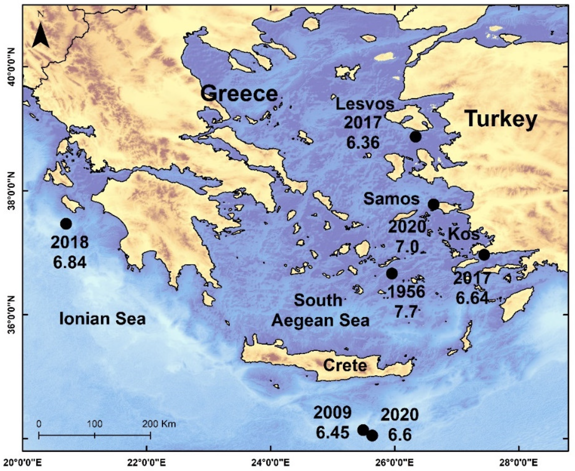
On 20 July 2017 at 22:31:12 UTC, a strong damaging earthquake (M
w6.64) shook the area of the southeastern Aegean Sea (
Table 1,
Figure 1) and triggered a tsunami wave that was observed in Kos Island, Greece, and in Bodrum peninsula, western Turkey [
9,
10,
11,
12]. In Kos port, the wave was measured at 1.5 m a.s.l. [
11]. During a field survey performed in the aftermath of the earthquake, in collaboration with Dr. Alessandro Annunziato, Joint Research Center (EC), among other elements of the tsunami impact, we observed one small fishing boat lying exactly at the spot of the arch in Phoinikon Avenue Bridge (
Figure 9). Initially we considered that it was removed there by the 20 July 2017 tsunami. However, after talking with local people, we verified that this boat was abandoned there for many years. This is consistent with the fact that the boat was in a situation of significant deterioration. Very likely, it was one of the boats that, according to the narration by the eyewitness of the 5 December 1968 tsunami, was removed ashore.
This is the first time that information about the 5 December 1968 tsunami has been offered to the tsunami community. It is of interest that the eyewitness did not mention earth-shaking at all, which is reasonable since the tsunami observation point lies at an epicentral distance of ~45 km. Since the earthquake was not of very large magnitude, combined with the fact that the wave was observed only in one coastal spot, we may suggest that the tsunami likely was generated by a submarine landslide caused by the earth-shaking close to the Kos port.
Eastern Corinth Gulf, Central Greece, 24 February 1981 (R = 4, K = 3 in Loutraki)
The Eastern Corinth Gulf was ruptured by a sequence of three destructive earthquakes occurring on 24 February (M
w6.58), 25 February (M
w6.32), and 4 March 1981 (M
w6.23) [
2] (
Figure 10). Mapped surface-fault traces [
50] imply that the first shock ruptured mainly offshore. According to those authors [
50], local people reported a tsunami of ~1 m high immediately following the first shock. Although this tsunami event is listed in previous catalogs, e.g., [
1,
6] it is worth presenting an instrumental record [
51] from the analog tide-gauge station of Posidonia situated in the epicentral area and belonging to the Hellenic Hydrographic Survey of the Greek Navy. The mareogram (
Figure 11) shows that the wave was indeed generated immediately after the first strong earthquake with peak-to-peak amplitude up to ~20 cm. The sea level oscillation in the bay lasted nearly four days.
Eastern Corinth Gulf, Central Greece, 4 March 1981 (R = 3, K = 3 in Corinth and in Loutraki)
A press report (“ΤA ΝEA”, TA NEA, 5.3.1981) noted that immediately after the third earthquake of 4 March 1981, a local tsunami ~1.3 m high was observed in Corinth city and at the nearby Loutraki town (
Figure 10). However, the supposed wave was not recorded at the Posidonia station.
Corinth Gulf, Central Greece, 18 November 1992 (R = 4, K = 2 in Corinth)
On 18 November 1992, at 21:10:43 UTC (23:10:43 local time), a strong earthquake of M
w5.89 [
2] occurred near Galaxidi town, central Corinth Gulf (
Figure 10) and was associated with a small tsunami. According to a press report (“AΠOΓΕΥΜAΤΙΝH”, APOGEYMATINI, 19 November 1992), a “tidal wave” was observed in the city of Corinth. Around midnight local time, a low-amplitude (~0.02 m) oscillation of the sea level was recorded at the Posidonia analog tide station (
Figure 12), which is situated at an epicentral distance of ~50 km. The sea disturbance lasted for about 2.5 h. This is the first time that this small event has been documented.
Preveza, Northwestern Greece, 26 May 2000 (R = 2, K = 2 in Rodia Lagoon)
In his report about a moderate earthquake (M
w5.55) (
Figure 3), a geologist reported [
52] that immediately after the earthquake, a local fisherman observed a “tidal wave” in the lagοon Rodia close to its borders with the lagoon Tsoukalio. The geologist, however, noted that he was unable to cross-check this information.
Skyros Isl., North Aegean Sea, Greece, 26 July 2001 (R = 1)
According to a press report (“ΕΛΕΥΘΕΡOΤΥΠΙA”, ELEFTHEROTYPIA, 30.7.2001), an eyewitness fisherman said that during the strong earthquake (M
w6.44) he was sailing offshore the northeastern end of Skyros Island (
Figure 3). Then, his boat rocked back and forth as if it had hit dry land. He added with emphasis, “I was unable to control the boat”. This account indicates a seaquake rather than a tsunami wave.
Corinth Gulf, Central Greece, 22 Aug. 2008 (R = 4, K = 6 in Loggos)
According to press reports (last accessed 21 February 2024), published on 23 August 2008, in the early afternoon of 22 August 2008, a sea wave of height h~2 m was observed in the coastal zone stretching from Akrata (
Figure 10) to Panagopoula, southwestern Corinth Gulf, but mainly from Valimitika to Loggos. It was reported that four persons were injured in their effort to escape. Soon after the event, one of us (G.P.) communicated with Mr. G. Zetos, Delfi Hotel, near Eratini, northwestern coast (
Figure 10). He reported that the wave was also observed along the coast of the hotel, with a height of ~1.5 m. Three waves were reported there, arriving a few minutes apart from each other. The wave penetrated inland to about 10–15 m, causing the removal of graves and sand.
No earthquake was registered before or after the tsunami, while port authorities verified that no sizable boat sailed in the area at that time. On the other hand, the weather was reported calm. We suggest that the wave was likely generated by an aseismic submarine landslide. Τhe area is prone to aseismic coastal and submarine landslides causing local but powerful tsunamis, such as the ones that occurred in 1963 and 1996.
Zakynthos, Ionian Sea, Greece, 13 September 2018
The “Shipwreck” beach in Zakynthos Isl. (“Navayio” in Greek) (
Figure 3) is a quite popular destination during summertime. The beach is located under an almost vertical cliff of ~200 m high. On 13 September 2018, around 13:15 local time, a section of the rocky cliff collapsed partly on the beach and partly on the sea surface (
Figure 13). The landslide volume was estimated at 5000 m
3. Some people were injured, and small boats overturned. A local but powerful sea wave triggered and inundated the beach violently, causing visitors to run away in panic. The event has been documented in pictures and video shoots taken by visitors (see links in the
Supplementary Materials).
Although that event was a minor one, it makes a characteristic example of the risk implied by local phenomena. For this reason, the authorities decided not to allow visits to the beach during 2023.
4. Results
We investigated for new observational material about tsunami-like sea disturbances that occurred in Greece and the surrounding areas from 1900 to 2023 and collected new material for 26 distinct events. A number of 21 events have been identified as tsunamis. Four events have been attributed to other types of sea disturbances, such as standing waves (seiches) in bays and seaquakes felt onboard vessels.
There is clear evidence that 15 out of 21 tsunamis have been of seismic origin, while four tsunamis were produced by landslides triggered by earthquakes. Two tsunamis have been attributed to aseismic landslides. The possible generation of tsunamis by mechanisms related either to seismic or to aseismic tsunamis has been discussed several years ago [
3,
4,
53].
Events unknown so far to the tsunami community include the ones of 1902 and 1938 in Central Greece, of 1933 and 1968 in Kos Isl., of 1981, 1992, and 2008 in Corinth Gulf, of 2000 in northwestern Greece, and of 2018 in Zakynthos Isl. However, the 1933 tsunami in Kos is not well documented. In the next lines, we summarize our results for three of the most important episodes of tsunami occurrences. The first is the powerful tsunami that followed the large earthquake (Mw7.30) of 9 February 1948 in Karpathos Isl. The second is the episode comprising three very strong earthquakes in the Ionian Sea during August 1953, while the third is the tsunami observed in Kos Isl. after a strong earthquake on 5 December 1968.
According to new eyewitness accounts, in the port of Pigadia, eastern Karpathos, after the large 1948 earthquake, the sea receded for ~650 m, and the people saw boats lying on the sea bottom and fish sparring out of the water. The bases of the rock islets Garonitso and Despotiko appeared. Soon after, a 2–3 m high tsunami returned violently and broke up all the boats, seriously damaged the ground floors of houses and of a church and left behind trunks and broken boats. In addition, crates washed away from customs warehouses. In some flat spots of the bay, the wave inundated inland for ~1 km and left behind seaweed and dead fish. People run in the fields to collect fish. The sea receded three times up to the islet Despotiko, and each time returned and engulfed everything. No fatalities were reported by the earthquake and the tsunami, but rumors said that an elderly lady drowned. During our field trip on 14 September 2020, we were guided by local people in Makris Gialos Bay, southeastern Karpathos, which is a new tsunami observation point. At that point, soon after the earthquake, the sea first receded and caused a boat tied there to sit on the bottom. Then, it returned and inundated inland at distance of ~150 m and reached an estimated run-up of ~2.0–2.5 m. After the sea recession, people ran to gather fish left ashore.
Very little has been known so far about tsunamis associated with the exceptional and quite destructive seismic sequence of August 1953 in the Ionian Sea islands. Our research substantially enriched the existing collection of tsunami observations with new material, although, in all the evidence, the tsunamis generated during the 1953 earthquake sequence have been only local events. From the evaluation of the various information sources examined, we may summarize the collected observations as follows.
After the first strong earthquake (Mw6.29) of August 9th, a powerful tsunami engulfed the moor and broke the sails from the boats in Vathy harbor, Ithaki Isl. During the same earthquake a seaquake was felt onboard a motorboat sailing offshore southwestern Cephalonia.
After the second earthquake (Mw6.53) of 11 August, on the beach of Vathy Bay, Ithaki Isl., a tsunami wave of ~1 m high inundated a coastal segment at the length of 1 km and penetrated inland up to 200 m from the shore, thus intensifying the panic of the people. The Customs Office of Vathy was flooded. After the first inundation, the sea withdrew, then returned and inundated the same area once more. A sea level rise and a seaquake were observed in the area of Sami town, eastern Cephalonia, nearly at the same time as the earthquake. In Argostoli town, western Cephalonia, seaquakes and strong standing waves occurred in the harbor.
In Poros Bay, eastern Cephalonia, nearly at the same time as the earthquake occurrence of 12 August, the sea water retreated from the harbor like the stream of a river. The harbor was rendered empty of water, and all the boats sat on the sand. After a few minutes, the seawater moved against the coast, filled the harbor, and washed away everything. Some people panicked and ran to higher ground. The water receded and returned once more, with the second wave being stronger than the first one. After another cycle of small recession, the water level remained permanently at least 40 cm lower with respect to its pre-seismic level. This is due to the well-documented co-seismic uplift of the area by 40–60 cm. In Argostoli Bay, western Cephalonia, several inundation–recession cycles were reported. The tsunami inundated up to ~100 m inland and reached the main town square. During the earthquake, the sea in the bay looked like boiling, and whirlpools were observed. In Vathy, the tsunami inundated the coast and advanced up to the town square, i.e., ~100 m inland. Some people were swept away, but no casualties were reported. Small seaweed pieces were left behind on the streets of the town. However, it is not clear if the same wave was observed in Poros and in Vathy. According to unverified information, the wave was caused by a coastal landslide. Seaquakes were felt onboard in the bays of Argostoli, Vathy, and Patras.
As for the tsunami that followed the 1968 strong earthquake (Mw6.10), which ruptured near Kos Isl., southeastern Aegean Sea, Greece, we found only an eyewitness account. However, the entire story he narrated is quite realistic and looks reliable. According to this account, near Kos port, the sea suddenly swelled and rose up while the weather was calm. The tsunami was as high as ~1.00–1.20 m, and because of this, the neighborhood and houses flooded. People were forced to go up to the roofs. In the port, old houses and shacks were damaged while boats broke. Where the carnage used to be, the wave swept ships and boats up to the streets. In July 2017, we observed one of these boats abandoned in the area. The water was stagnant for 4–5 h and receded only after some days.
5. Discussion
The modern era of tsunami observations in the Mediterranean Sea started only about 15 years ago. In that period some tsunamis (
Table 1) have been documented in digital tide-gauge records and video shooting as well as by observations collected during post-event field surveys. For past tsunamis, a standard procedure for tsunami documentation is based on the collection of observational material from every source available, like scientific and press reports, archives, eyewitness accounts, photographs, and analog tide-gauge records. An additional procedure is to perform retrospective field surveys in areas inundated by past tsunamis. The bulk of observations compiled in our study have been collected by following these procedures. However, observational material of such a kind is inhomogeneous and susceptible to many uncertainties. For example, usually, only rough estimations can be made about fundamental hydrodynamic features of tsunamis, such as the wave height, inundation distance, and run-up. For these reasons, the reproduction of relevant information found in the various sources examined has been made as faithfully as possible.
In some instances, the collected observations indicate event features that do not imply tsunami generation but other types of sea disturbances, e.g., standing waves or seaquakes. Therefore, an important issue is the characterization of a particular event as a real tsunami. Consequently, for each event examined, we assigned a tsunami reliability index. This practice may help future researchers to re-examine the characterization of past events.
Our observations compilation includes not only sizable but also small tsunamis, which is a practice that needs an explanation regarding its usefulness. This practice concentrated a consensus among the tsunami community involved in the compilation of the New European Tsunami Catalogue in the frame of EC-supported research projects since the beginning of the 1990s. The reason is two-fold. First, observations about small tsunamis may help in better understanding tsunami generation mechanisms. Second, the cataloging of small tsunamis is quite useful for studying the scaling of tsunami size with important implications for the tsunami hazard and risk assessment with statistical and probabilistic methods based on incomplete and uncertain tsunami catalogs, e.g., [
53,
54].


