
Bathymetry Surveys of Post-Mining Pit Lakes Formed after Exploitation of Lignite †

“Poltegor—Instytut” Instytut Górnictwa Odkrywkowego, ul. Parkowa 25, 51-616 Wrocław, Poland
*
Author to whom correspondence should be addressed.
†
Presented at International Conference on Raw Materials and Circular Economy, Athens, Greece, 5–9 September 2021.
Mater. Proc. 2021, 5(1), 117; https://0-doi-org.brum.beds.ac.uk/10.3390/materproc2021005117
Published: 9 March 2022
(This article belongs to the Proceedings of International Conference on Raw Materials and Circular Economy)
Abstract
:Flooding of post-mining voids is one of the most common methods of post-mining areas reclamation. The article presents selected post-mining lakes investigated within the research project “Risk assessment of final pits during flooding” (RAFF), co-financed by the Research Fund of Coal and Steel and the Polish Ministry of Education and Science. The main objectives of the project are focused on the development of comprehensive models that can be used for risk assessment purposes. The innovative outcomes of the project will help to elaborate methodologies and guidelines to improve the safety and security of the flooding of post-mining open pits as well as sustainable management of the environment. In this paper, the results of bathymetry surveys carried out on pit lake Lubstów belonging to the PAK Konin Lignite Mine SA are presented.
1. Introduction
Although flooding of post-mining excavations is a very difficult process, it remains a commonly used reclamation method for opencast mines. The difficulties are mainly related to the complexity of geological, hydrogeological and geotechnical conditions, the complexity of the flooding process itself and its long duration. Flooding of final pits typically causes changes with short- and long-term consequences such as soil instability that may result in landslides and subsidence [1].
One of the most common reclamation practices is the formation of a pit lake by flooding the remaining voids after the mine closure. These voids can be filled by artificial flooding or through natural hydrological processes such as precipitation or ground water infiltration. Pit lakes offer the opportunity to enhance the recreational or ecological benefits by re-landscaping and re-vegetating the shoreline, by creating aquatic life, and maintaining water quality. Their value as resources for recreation, fisheries, water supply for industry and agriculture, heat pump applications, scientific studies and wildlife habitat, depends mostly on their topography, their safety characteristics (susceptibility to slides, rock falls, etc.), their hydrological characteristics (interaction with groundwater and surface waters and the quality of both) and climate. The creation of a pit lake may be a regulatory requirement to mitigate environmental impacts from mining operations, and/or be included as part of a closure and reclamation plan [2].
Pit lakes created after the completion of open-pit coal mining operations have different characteristics compared to those created in metallic mines and quarries. Their morphometry depends on the shape of the coal seam and the type of mining method used. Large scale open-pit coal mines are usually developed on relatively level terrain in sedimentary rocks of low mechanical strength, while overburden is removed and coal is mined along a long linear front. As the mine front advances, overburden is used to reclaim mined-out parts of the pit (internal waste dump). At the end of the mine life, this commonly leaves an elongated and relatively shallow pit lake. During open-pit exploitation, the risk of potential failure increases with the size of the mine. In large open pits, such as Bełchatów, there are many aspects which have to be taken into consideration during exploitation [3] but during the flooding of pit lakes, the types of risks will be different.
The reclamation of large lignite mines, often with a volume of billions of cubic meters, is highly connected with geotechnical and hydrogeological issues. Unpredicted geotechnical phenomena occur quite often during flooding, as in the Pątnów open pit [4] and Zülpich Mitte [5] or after flooding as in the Concordia pit lake near Nachterstedt, where a massive landslide with a volume of ca. 1 million m3 took place in 2009 [6].
As a part of the RAFF project “Risk assessment of final pits during flooding”, the Poltegor Institute undertook works to create methods of optimizing the processes of final pit flooding in opencast lignite mines and to minimize the risks that occur during this process. This project is financed by the Research Fund for Coal and Steel and by the Polish Ministry of Education and Science. The consortium implementing the project includes:
- “Poltegor-Institute” Institute of Opencast Mining (project leader)—Poland;
- University of Nottingham—Great Britain;
- VUHU Brown Coal Institute—Czechia;
- Technical University of Crete—Greece;
- University of Petrosani—Romania;
- GIG Central Mining Institute—Poland;
- PKU Palivový Kombinat Ústí—Czechia;
- INERIS Institut National de L’Environnement Industriel et des Risques—France;
- SUBTERRA Ingeniería—Spain;
- CERTH Centre for Research and Technology Hellas—Greece;
- CTL Maczki Bór SA—Poland;
- CEO Oltenia—Romania.
One of the tasks within the RAFF project is the identification of the hazards during the flooding of pit lakes. To gain an understanding of the phenomena that occurs during the flooding of pit lakes, it is necessary to compare existing conditions with the initial designs. This information enables us to evaluate the movements that may have occurred since the construction of a pit void and to define the mechanisms driving these movements. This information may provide a warning of imminent failure. The gathering of input data for the design of flooded pit lakes was completed during the initial stages of the RAFF project realization. On the basis of these data, pit lakes for bathymetric measurements of slopes were chosen.
2. Post-Exploitation Lakes Selected for Research
2.1. Lubstów
The Lubstów post-exploitation reservoir is located in the Greater Poland Voivodeship, in the Konin County. The reservoir was created when the exploitation of Lubstów open-pit mine ended. The Lubstów open-pit belonging to PAK Kopalnia Węgla Brunatnego Konin was exploited between 1982 and 2009. During this period, 107 million tons of lignite were mined. It was the largest open pit in the Konin Basin, characterized by the most favorable mining and geological conditions.
According to the reclamation strategy adopted by PAK KWB Konin, the lignite post-mining areas are to be used for recreational and retention purposes. In the vicinity of the Lubstów post-exploitation lake, it is planned to create a water sports center, a playground facility for children, multiple holiday centers and transport infrastructure. Currently, the Lubstów reservoir is still being filled with water. Its target area will be approx. 480 ha. The water level in the lake will be 83.5 m.a.s.l., and the maximum depth will be 55 m [7,8].
2.2. Most
The post-exploitation Lake Most is located in Czechia. The history of the Most lignite opencast mine dates back to the beginning of the post-war period, when on 12 July 1945, the Richard mine was renamed the Ležáky mine. In 1952, the Ležáky mine was incorporated into the North Bohemian Brown Coal Union. The Most opencast was incorporated into the Ležáky mine and was exploited in parallel with the operation of the other lignite opencasts.
When the artificial flooding of the Most opencast began in October 2008, the post-mining lake had an area of 21.60 ha and a depth of 21.12 m. Within two months from the start of the artificial flooding process, the water level rose by 9.50 m, while the water table surface doubled to 45.42 ha. In May 2014, the final stage of the Lake Most flooding process began. A constant water level of 199.00 m.a.s.l. with its area of 309.09 ha and depth of the lake 75.0 m was reached in September 2014 [9].
2.3. South Pesteana
The Romanian South Pesteana post-exploitation lake is located at the southeastern end of the Rovinari Coal Basin in Urdari and Plopşoru. The concept of the opencast reclamation covered the creation of a post-mining lake that would be able to perform various functions in the future. The planned surface level of the lake is 125.0 m.a.s.l., its area is 154.3 ha and depth is up to 45.0 m.
A stable water level in the reservoir is maintained by a pumping station that discharges excess water through a canal to the Jiu River. Such a solution protects local households against floods, contributing to minimizing the risk of landslides at the same time [9].
3. Bathymetric Measurements
As a part of the work carried out under the RAFF project, two of the above-mentioned post-exploitation lakes were selected for bathymetric measurements, i.e., Lubstów and Most. Bathymetric measurements were carried out in order to determine the geometric changes occurring in the slopes of these reservoirs. In this article, bathymetry results from Lubstów pit lake are presented.
Bathymetric measurements on the Lubstów reservoir were obtained using the following equipment:
- Geodetic GNSS RTK receiver integrated with the GPS antenna, resistant to interference and capable of eliminating multi-path signals;
- Controller for the GNSS receiver;
- Single beam echo sounder (SBES) with a transducer with a maximum measurement depth of up to 75 m, accuracy of 2.5 cm and frequency of 2 Hz.
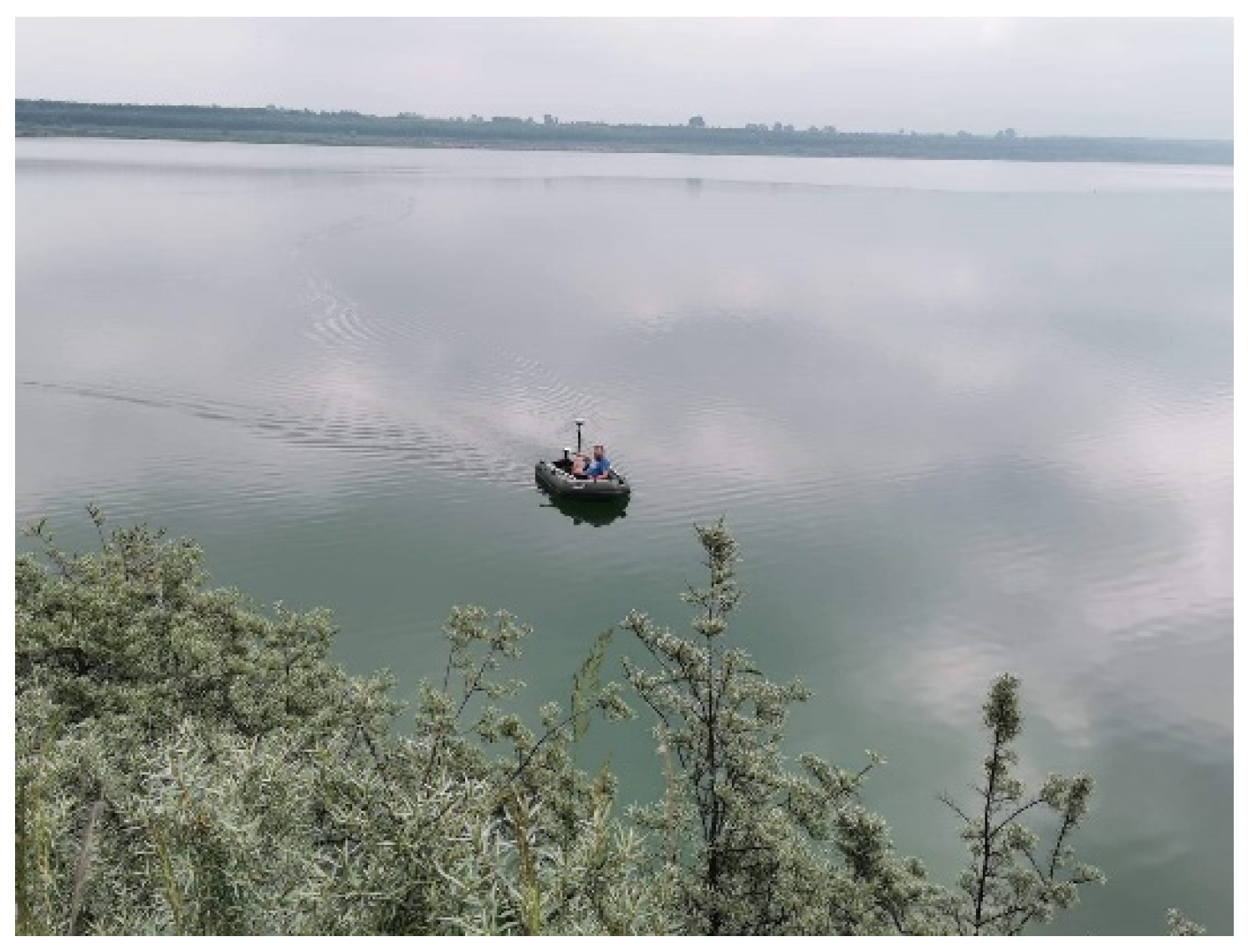
The above-mentioned devices were mounted on a pontoon (Figure 1).
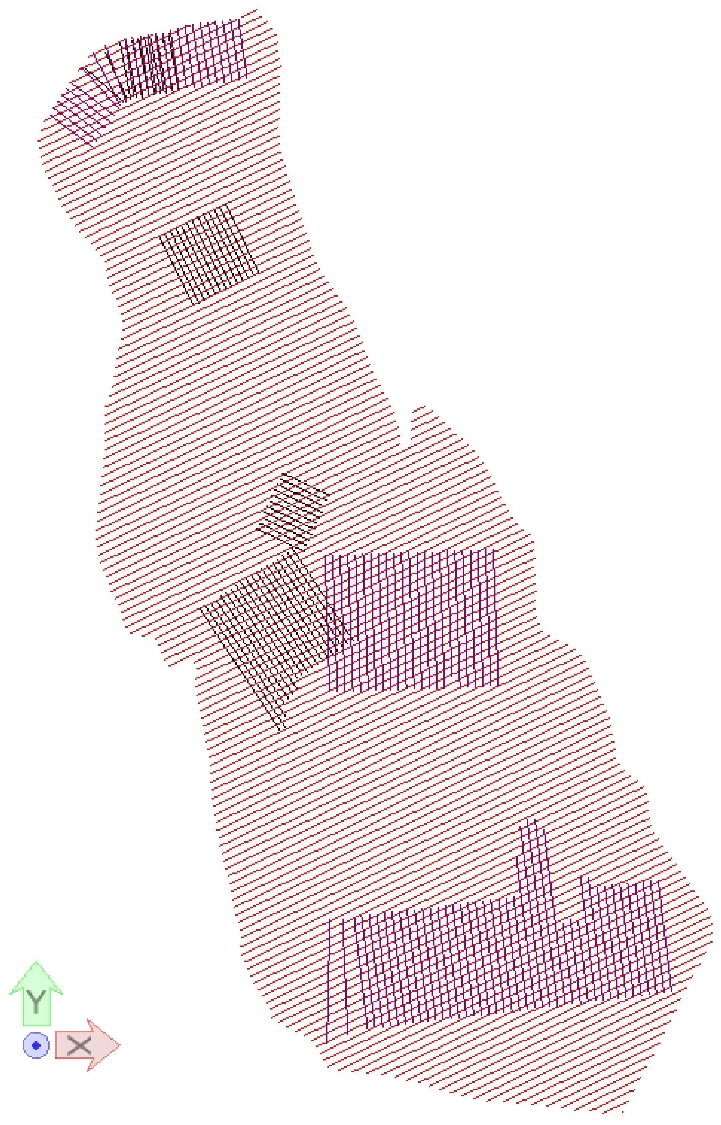
Before bathymetric measurements commenced, a measurement plan was developed based on archival data and including the recognition of the entire reservoir, with particular emphasis on places with complex geometry, such as artificial embankments inside the pit lake and steep slopes. The planned measurement paths are shown in the figure below (Figure 2).
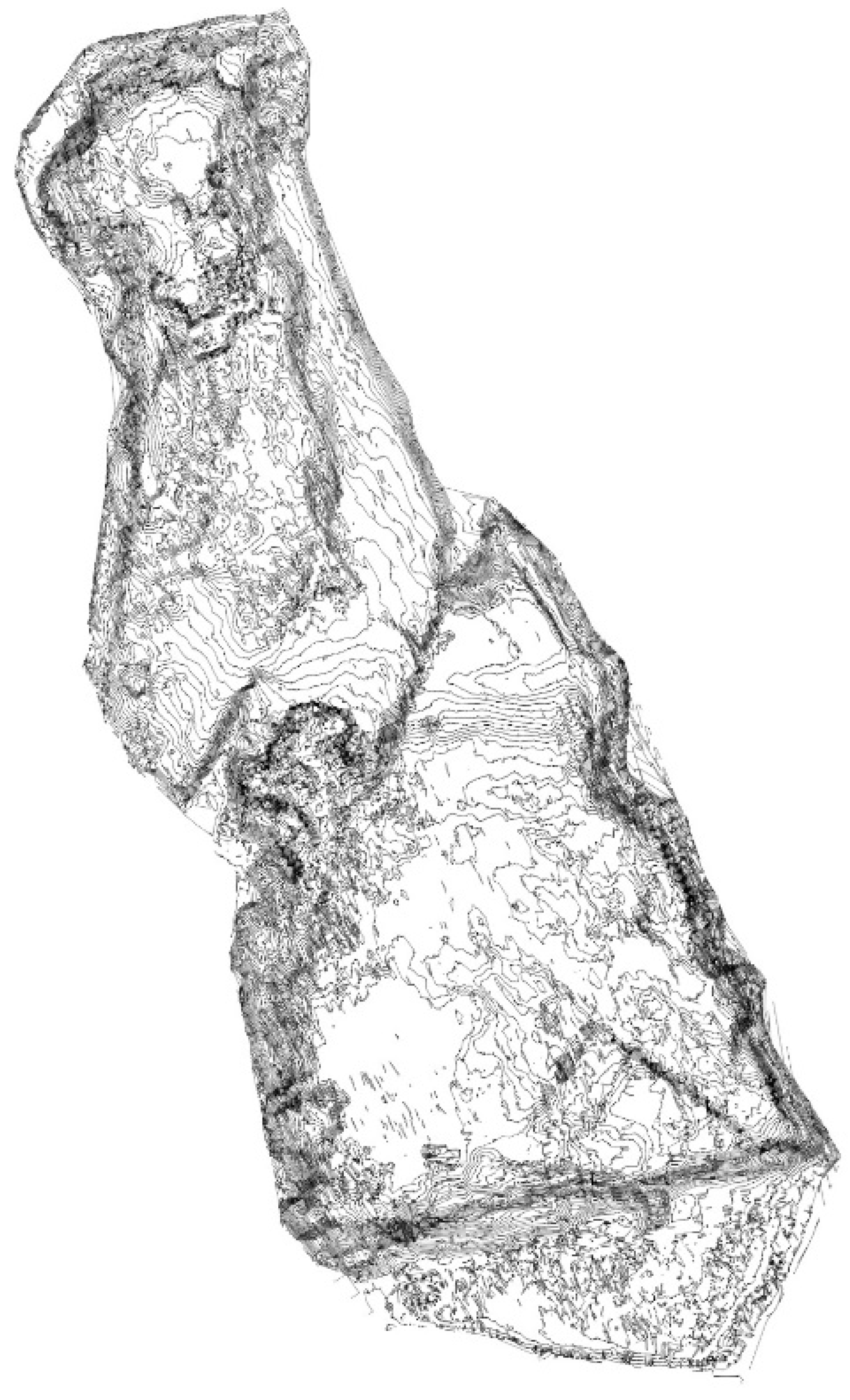
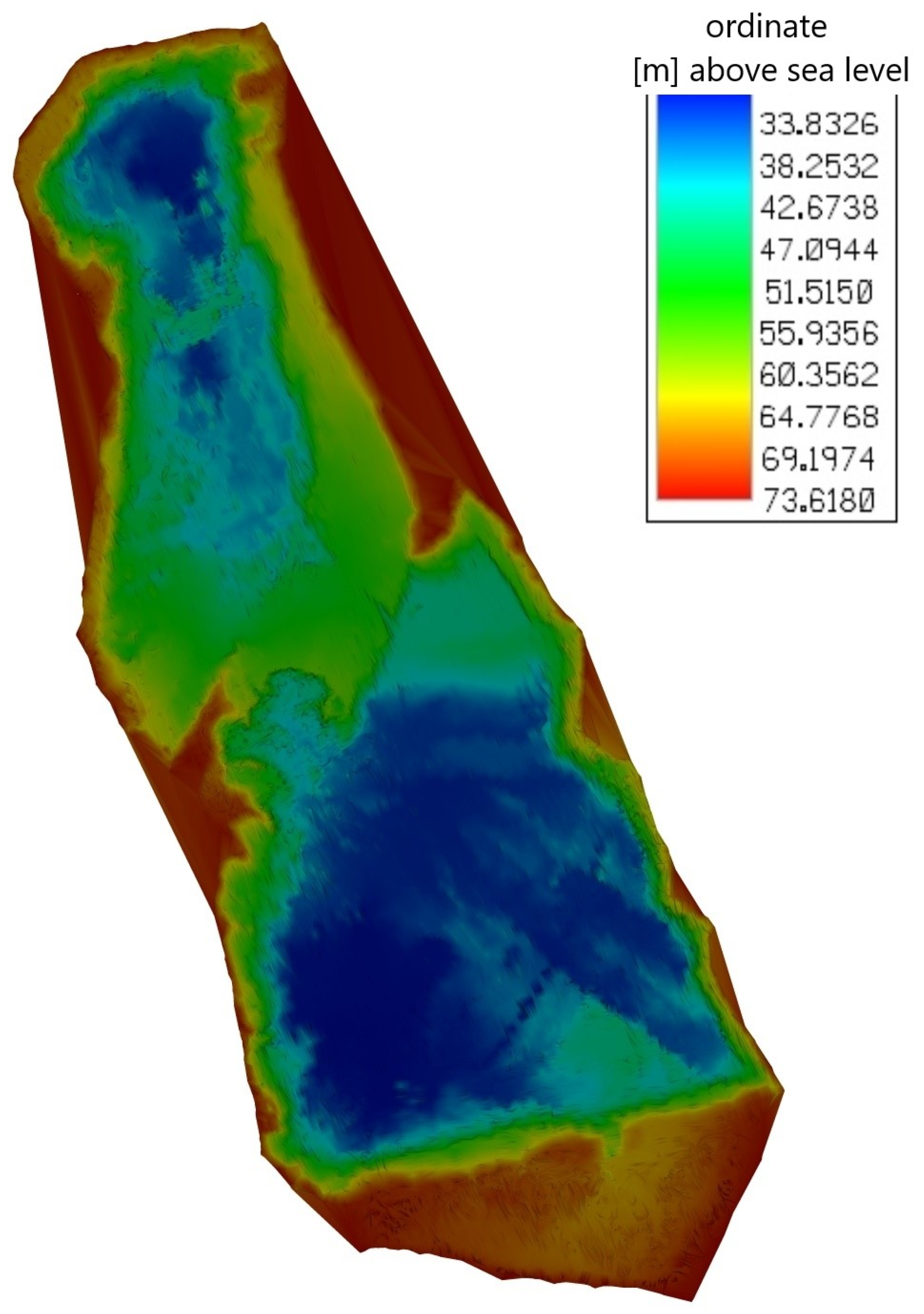
During the bathymetric measurements of the Lubstów reservoir, a total of 280,000 measurement points were obtained on the total length of 286 km of measurement paths [10,11]. Based on the coordinates of the measurement points, an up-to-date three-dimensional model of the bottom and slopes of the reservoir was created (Figure 3 and Figure 4).
The bathymety survey performed showed that changes in the geometry of the pit lake’s bottom and slopes are noticeable, especially in the central part of the lake, where an artificial barrier built from overburden soils was localized. The numerical description of washing out the barrier as well as second bathymetry survey will be performed by the Poltegor Institute in the latter stages of the RAFF project.
4. Conclusions
The bathymetric measurements conducted will be the basis for determining the influence of geometric changes on the stability of slopes during the process of post-mining reservoir flooding. These calculations, together with the data collected from the above-mentioned post-mining lakes, concerning their geological structure, hydrogeological and climatic conditions, anthropogenic factors and geotechnical hazards, among others, will be the basis for the RAFF project partners to develop a new methodology for risk assessment related to the processes of post-mining reservoir flooding.
Author Contributions
Conceptualization, A.B. and J.S.; methodology, A.B.; software, A.B.; validation, A.B., J.S. and B.R.; formal analysis, A.B., J.S. and B.R.; investigation, A.B.; resources, A.B., J.S. and B.R.; data curation, A.B. and B.R.; writing—original draft preparation, A.B.; writing—review and editing, A.B., J.S. and B.R.; visualization, A.B.; supervision, A.B., J.S. and B.R.; project administration, A.B. and B.R.; funding acquisition, A.B., J.S. and B.R. All authors have read and agreed to the published version of the manuscript.
Funding
This project has received funding from the Research Fund for Coal and Steel under grant agreement No. 847299. The article is published as a part of an international project co-financed by the program of the Minister of Science and Higher Education entitled “PMW” in the years 2019-2022; contract No. 5030/FBWiS/2019/2.
Institutional Review Board Statement
Not applicable.
Informed Consent Statement
Not applicable.
Data Availability Statement
The data presented in this study are available on request from the corresponding author.
Conflicts of Interest
The authors declare no conflict of interest.
References
- Szczepiński, J.; Bajcar, A.; Rogosz, B. Projekt badawczy “Ocena zagrożeń w zbiornikach końcowych kopalń odkrywkowych podczas wypełniania ich wodą (RAFF)”. Węgiel Brunatny 2019, 3, 32–36. [Google Scholar]
- Gammons, C.H.; Harris, L.N.; Castro, J.M.; Cott, P.A.; Hanna, B.W. Creating lakes from open pit mines: Processes and considerations-with emphasis on northern environments. Can. Tech. Rep. Fish. Aquat. Sci. 2009, 2826, ix + 106 p. [Google Scholar]
- Jończyk, M.; Organiściak, B. Zagrożenia naturalne w zakładzie górniczym KWB “Bełchatów”: Rozpoznawanie i zapobieganie zagrożeniom. Górnictwo i Geoinżynieria 2010, 34, 249–257. [Google Scholar]
- Bajcar, A. Stateczność Zboczy Końcowych w Fazie Likwidacji Kopalni Odkrywkowych Węgla Brunatnego. Doctoral Dissertation, Wroclaw University of Science and Technology, Wrocław, Poland, 2008. [Google Scholar]
- Pierschke, K.J.; Boehm, B. Geomechanische und wasserwirtschaftliche Aspekte bei der Restseegestaltung im Rheinischen Braunkohlenrevier. Braunkohle 1996, 48, 647–653. [Google Scholar]
- Cała, M.; von Bismarck, F.; Illing, M. Geotechnische und Umweltaspekte bei der Rekultivierung und Revitalisierung von Bergbaufolgelandschaften in Polen und in Deutschland; Wydawnictwo AGH: Kraków, Poland, 2014. [Google Scholar]
- Kasztelewicz, Z. Rekultywacja Terenów Pogórniczych w Polskich Kopalniach Odkrywkowych; Fundacja Nauka i Tradycje Górnicze: Kraków, Poland, 2008; ISBN 978-83-88316-94-4. [Google Scholar]
- PAK Kopalnia Węgla Brunatnego Konin S.A. Available online: http://www.kwbkonin.pl/index.php/kierunki-rekultywacji/rekultywacja-wodna/ (accessed on 28 June 2021).
- Burda, J.; Bajcar, A. Post Exploitation Lakes; Zpravodaj Hnědé uhlí: Most, Czech Republic, 2020. [Google Scholar]
- Survey of bottom and slopes of flooded artificial reservoirs. Deliverable 1.2.1. Project RAFF materials. Unpublished manuscript. 2020.
- Szczepiński, J.; Bajcar, A.; Rogosz, B. Jeziora poeksploatacyjne utworzone po wydobyciu węgla brunatnego w badaniach projektu RAFF. Węgiel Brunatny 2021, 1, 28–32. [Google Scholar]
Figure 1.
Measurement system installed on a pontoon.

Figure 2.
Measurement paths for Lubstów lake [10].
Figure 2.
Measurement paths for Lubstów lake [10].

Figure 3.
Isolines of the bottom and slopes of Lubstów reservoir obtained from the bathymetric measurements [10].
Figure 3.
Isolines of the bottom and slopes of Lubstów reservoir obtained from the bathymetric measurements [10].

Figure 4.
Three-dimensional model of the bottom and slopes of Lubstów reservoir.

Publisher’s Note: MDPI stays neutral with regard to jurisdictional claims in published maps and institutional affiliations. |
© 2022 by the authors. Licensee MDPI, Basel, Switzerland. This article is an open access article distributed under the terms and conditions of the Creative Commons Attribution (CC BY) license (https://creativecommons.org/licenses/by/4.0/).
Share and Cite
MDPI and ACS Style
Bajcar, A.; Szczepiński, J.; Rogosz, B. Bathymetry Surveys of Post-Mining Pit Lakes Formed after Exploitation of Lignite. Mater. Proc. 2021, 5, 117. https://0-doi-org.brum.beds.ac.uk/10.3390/materproc2021005117
AMA Style
Bajcar A, Szczepiński J, Rogosz B. Bathymetry Surveys of Post-Mining Pit Lakes Formed after Exploitation of Lignite. Materials Proceedings. 2021; 5(1):117. https://0-doi-org.brum.beds.ac.uk/10.3390/materproc2021005117
Chicago/Turabian StyleBajcar, Adam, Jacek Szczepiński, and Barbara Rogosz. 2021. "Bathymetry Surveys of Post-Mining Pit Lakes Formed after Exploitation of Lignite" Materials Proceedings 5, no. 1: 117. https://0-doi-org.brum.beds.ac.uk/10.3390/materproc2021005117