
A BIM-IFC Technical Solution for 3D Crowdsourced Cadastral Surveys Based on LADM


Lab of Photogrammetry, Department of Topography, School of Rural and Surveying Engineers, National Technical University of Athens, 9 Iroon Polytechniou St., 15780 Athens, Greece
*
Author to whom correspondence should be addressed.
Earth 2021, 2(3), 605-621; https://0-doi-org.brum.beds.ac.uk/10.3390/earth2030035
Submission received: 10 June 2021
/
Revised: 9 August 2021
/
Accepted: 25 August 2021
/
Published: 6 September 2021
Abstract
:In most countries, three-dimensional (3D) property units are registered utilizing two-dimensional (2D) documentation and textual description. This approach has several limitations as it is unable to represent the actual extent of complicated 3D property units in space. As traditional procedures often lead to increased costs and long delays in 2D cadastral surveying, a fast, cost-effective, and reliable solution is needed to cope with the remaining global cadastral surveying needs. Crowdsourcing has claimed a critical role as a reliable methodology with huge potential regarding the realization of 2D and 3D cadastral registration in both an affordable and a timely manner. Many large modern constructions are now planned and constructed based on BIM technology all over the world. The utilization of 3D digital models, such as building information models (BIMs), and the establishment of a connection with the international standard of the Land Administration Domain Model (LADM) could be a solution for the rapid integration of these units into a 3D crowdsourced cadaster with a better representation of the cadastral boundaries of these units, a detailed visualization of complex infrastructures, and an enhancement in the interoperability between different parties and organizations. In this paper, the potential linkage between the BIM, the LADM, and crowdsourcing techniques is investigated in order to provide an effective technical solution for the integration of large new constructions into 3D crowdsourced cadastral surveys. The proposed framework is tested on a building block in Athens, Greece. The potential, perspectives, and reliability of such an implementation are assessed and discussed.
1. Introduction
The ever-increasing prevalence of multidimensional infrastructures in the urban environment raises the complexity of land administration procedures, introducing new challenges to the recording, management, and visualization of the spatial extent of vertically stratified cadastral objects. Traditional 2D cadastral systems cannot fully represent and visualize the spatial information, providing an incomplete illustration of the structures and space usages of complex buildings both above and below the ground. The on-going dominance of such limitations jeopardizes citizens’ proprietary rights, restrictions, and responsibilities (RRRs) and complicates the valuation, taxation, planning, and control of land use and natural resources [1,2]. Traditional cadastral systems require the necessary legal, institutional, and technical adjustments to be able to cope with the multidimensional environment.
In recent decades, 3D cadasters have been a major research topic as modern developments in computer graphics and 3D modeling techniques have made their implementation technologically feasible. However, the implementation of a fully functional 3D cadaster has not been achieved yet [3]. Since 2012, the Land Administration Domain Model (LADM) (ISO-TC211 2012) has constituted the international standard for 2D and 3D cadastral data modeling. Several countries have developed legal procedures and prototype systems for the registration of RRRs on 3D property units, developing interesting approaches regarding the initial acquisition and visualization of 3D cadastral data [4,5,6,7,8,9,10]. Despite the fact that the LADM offers several representation choices for cadastral data, a determination on acceptable 3D cadastral object geometries has yet to be made. So far, several approaches have been proposed by researchers aiming to settle a link between the legal and physical counterparts of 3D cadastral objects. Most of these investigations try to implement this connection through the usage of application schemas and technical data models, such as the City Geography Markup Language (CityGML), IndoorGML, BIM/Industry Foundation Classes (IFCs), LandXML, and InfraGML [11,12,13].
Obviously, there are several different alternative data structures that may be exploited to describe 3D cadastral objects. Among them, the Building Information Model (BIM) is indisputably one of the most comprehensive and intelligent 3D digital approaches able to manage buildings with composite structures and enable communication between stakeholders with different backgrounds [14]. BIMs represent the geometry of the complex physical buildings’ spaces (rooms, corridors, walls, and floors) and can be modeled, managed, and maintained hierarchically in BuildingSMART open exchange standards, such as the IFC standard, enabling communication and the exchange of building information through different platforms. The integration of the BIM/IFC and the LADM standard may provide a valuable input to the 3D cadaster for each individual property as well as its surrounding properties, allowing the capture of a clearer picture regarding properties’ RRRs. This view is strengthened by the fact that, nowadays, the main source of 3D building information on new buildings is BIMs. Therefore, a number of BIMs are available and can be used as an accurate basis for the collection of the needed 3D cadastral information. By laying the appropriate foundations today, BIMs may be the basis for the development of 3D cadasters in future urban centers, as they can include a wealth of useful information, such as land/property uses, property values, and energy classes.
However, as was proven [15,16], traditional cadastral surveying procedures require time and funds, which may gradually increase, complicating or even prohibiting the completion of both 2D and 3D cadastral surveys. This may lead to an increment in rights holders’ uncertainty regarding their rights as well as the time and costs involved in land and property transactions and mortgages, blocking the real estate market and inhibiting poverty reduction. Nevertheless, beyond these drawbacks, significant progress has been achieved in the field of 2D and 3D cadastral surveys, that may be able to minimize the time and costs involved in the necessary procedures, utilizing modern techniques and technological achievements. As was proven during earlier stages of our research, crowdsourcing techniques may be utilized for the implementation of 2D [17,18,19,20,21] and 3D [22,23,24,25,26,27] cadastral surveys, minimizing the cost of and time required for the surveys while ensuring the geometric accuracy and reliability of the collected data. Although 2D crowdsourced cadastral surveys have been tested and their pilot implementation started in some cadastral agencies [21,28], 3D crowdsourced cadastral surveys still need further investigation. The (re)usage of existing BIMs based on open exchange standards, such as the IFC, seems to be an interesting solution, enabling the further reduction of the costs and duration of the cadastral surveys and providing a promising result [29].
This paper is part of ongoing research aiming to develop a technical tool and a methodology for the collection of data on and the management, maintenance, and 3D modeling of cadastral units. The main objective of our research is to establish a more generalized framework that is adjustable to the available geospatial infrastructure and financial situation of each country, including even regions that still lack a 2D cadastral data registration procedure. To date, several different categories of data have been investigated as potential sources of 2D and 3D crowdsourced cadastral information. In this paper, an innovative crowdsourced technical solution based on the LADM standard and BIM data is designed and proposed. The main concern of this research is to provide an alternative LADM-based approach to the acquisition, registration, and representation of 3D cadastral objects that can be used to explore the potential utilization of BIM data when and where they are available. The paper is structured as follows. Section 2 presents background information regarding the contemporary practices for 3D cadasters and related work regarding the utilization of a BIM as a source of 3D cadastral data. Section 3 presents the structure of the proposed technical solution. The conceptual schema of the developed LADM-based DBMS and the developed web-based cadastral application are described and presented. Section 4 presents a test implementation of the developed system in a building block in Athens, Greece as well as the results of the overall procedure. Finally, Section 5 presents the main conclusions by reference to perspectives on and the reliability of the proposed crowdsourcing framework as a basis for the compilation of a well-functioning and affordable 3D cadaster as well as our initial thoughts on future work.
2. Contemporary Practices for 3D Cadasters
In recent decades, 3D cadasters have been a major topic of interest as they present the spatial extent of ownership and designate the 3D property rights, restrictions, and responsibilities. However, the implementation of a fully functional 3D cadaster has not been achieved yet [3]. In order to realize a 3D cadaster, three main stages of development should be considered: (i) the legal stage; (ii) the institutional stage; and (iii) the technical stage [30]. The legal stage consists of one of the most important phases for the implementation of 3D cadasters, as without the laws and the legal definition of 3D properties the cadastral surveys and the registration of 3D objects and rights are meaningless [31]. Subsequently, the institutional stage includes the authority and the duties of the public registration and mapping institutions for 3D registration [32]. It describes what information is needed for registration and how this information will be structured, registered, stored, and presented. It is responsible for the management, update, and distribution of the 3D cadastral data as well as the required workflow for the implementation of the 3D cadaster. Finally, the technical stage concerns how the 3D spatial information of the property units is integrated with the existing cadasters [33]. To date, the main research interest in the technical stage has focused on spatial data infrastructures, Geographic Information Systems (GISs), the LADM, database management systems, 3D visualization, and 3D geometric representation, topology, and data exchange formats.
With the emergence of the Land Administration Domain Model (LADM ISO 19152, 2012) in 2012, a new era has begun for both 2D and 3D cadasters. Based on this ISO standard, many countries can design prototype systems and approaches for the implementation of country-level 3D cadasters [34,35,36]. Each country handles the 3D aspect according to its current legislation and cadastral background. The LADM has become a very useful tool as it provides a flexible conceptual schema as a basis for the development of 2D and 3D cadasters while establishing a shared ontology, enabling communication between the involved parties within one country or between different countries, and facilitating data exchange in heterogeneous and distributed land administration environments [37]. However, the LADM lacks a determination regarding the acceptable 3D geometries and representations of 3D cadastral objects, which is a subject of active research [34].
In the meantime, there have been significant changes in the data collection techniques, the visualization of 3D data, and the utilization of crowdsourced data, BIM data, and other data structures [38,39,40]. At this point, another weakness of the LADM is the absence of a connection between the LADM and widely known spatial models, such as the BIM and IndoorGML [41]. Such rich data models are nowadays utilized in several application areas with great efficiency and have become a valuable data source for Geographic Information Systems (GIS) such as 3D cadastral systems. This has resulted in the development of various approaches to modeling the 3D information on individual units utilizing the GML-based (CityGML, IndoorGML) and IFC-based (BIM) spatial data models. In addition, other studies on 3D cadasters are being supported in projects under the subheadings of ‘Smart Cities’ and ‘Digital Twins’ within the scope of the European Union Horizon 2020 grant program. The main objective of these studies is to provide an infrastructure enabling the design, management, and planning of sustainable cities by integrating 3D digital cadastral information with other data, such as data on energy, air pollution, mobility, and temperature [42].
In recent years, there has been increased interest in linking 3D property models and cadastral systems in many countries [43]. Several studies concerning the registration and visualization of 3D properties are active internationally in order to develop sustainable solutions in terms of the legal and economic issues. The BIM provides a valuable tool that is rich in content and able to provide input to a 3D cadaster, both for each property unit itself and for its surrounding property units and parcels. The BIM can be translated in BuildingSMART’s open exchange standard, IFC, which provides the capability to model the legal and physical dimensions of urban properties [44]. A properly enriched IFC model may satisfy the requirements of cadastral legal spaces, enabling the extraction of cadastral data from both as-designed and as-built BIMs [45]. To enhance this notion, [29] designed a workflow to establish a bridge between a BIM and a GIS through developing an extended IFC data structure able to incorporate the information on 3D RRRs as the input for the land registry of The Netherlands. In [13], the authors investigate two potential approaches to integrating physical information provided through the IFC standard and legal information provided by the LADM data model. The first approach describes how the IFC standard may be extended to the land administration domain, while the second approach proposes the incorporation of physical elements from the IFC standard into a potential future update of the LADM. In [46], the authors propose a potential conceptual model for the integration of IndoorGML and the LADM. The main objective of this research is to assess the proposed model and highlight its possibilities and shortcomings during its conversion to a technical model. In [47], the authors investigate the potential integration of a BIM, cadastral information, and a GIS for the visualization of 3D cadasters in urban environments. The proposed framework utilizes an IFC model in order to link physical and legal spaces for cadastral visualization on the building level. The main conclusion is that the integration of the cadastral information, the BIM, and the GIS is possible on both a conceptual and a data level, facilitating communication between the involved parties. The authors of [48] present an overview of the ongoing international standardization activities, focusing on the LADM ISO and the ISO 19166 Geographic information—BIM to GIS conceptual mapping (B2GM) standard, which is still under development. This research highlights the importance of a transforming mechanism between BIM data and GIS projects, especially for the concept of “smart cities”. As indicated, BIMs may serve well as an important and detailed data source for the establishment of 3D spatial units. Furthermore, [49] proposed a similar web-based approach, aiming to combine a BIM and a GIS, for the effective management of 3D cadastral information and building data in high detail within a common platform. For the exchange and linkage of 3D spatial information between the two systems, the IFC standard is used.
However, the benefits of 3D cadasters might be outweighed by the costs. The approaches available at present are both time consuming and expensive, delaying the implementation of 3D cadasters. Thus, an alternative approach is needed for the initial implementation of both formally and informally developed urban areas, as it may empower tenure security, improve property management, formalize property markets, and enable a reduction in poverty. Practical experience has demonstrated that the utilization of cutting-edge technologies and crowdsourcing techniques in the development of 2D and 3D cadastral surveying procedures, in order to minimize the necessary time and cost, has already been achieved with very promising results [18,19,20,21,50,51].
Ellul et al. [52], present an interesting crowdsourced approach that aims to collect information regarding the land and property ownership situation. They developed a web-based application that enables the user to select his/her situation from several groups of ownership situations sketched out by the research team. In [22], an economic and timely procedure for 3D cadastral data acquisition and the 3D visualization of real properties as block models (LoD1) on a mobile phone’s screen in real time is presented. The mobile application enables the generation of 3D building models through an automated modeling algorithm. The user is asked to digitize the boundaries of his/her property unit on the available basemap, and this information is processed together with other geometric data (such as height, the floor where the property is located, etc.) in order to provide the 3D property model. As a basemap, a recent orthophoto of the area under cadastral survey overlaid with 2D floor plans may be the best option for an accurate, assured, and authoritative (AAA) 3D cadaster [53]. Otherwise, other platforms, such as an aerial photo, may be used, reducing the geometric accuracy significantly. In such cases, land parcel boundaries and building footprints should be visible. A similar approach is proposed by [27], with the difference that the developed mobile application is able to manage and visualize 3D property models both above and below the land surface. Subsequently, [26] exploits the experience gained by the previous studies in order to establish a LADM-based database and a methodology appropriate for proceeding with 3D property unit registration and visualization exclusively through the developed mobile application.
However, these crowdsourced solutions rely on specific conditions and assume that the necessary horizontal spatial data and infrastructure/floor plans are available. Otherwise, alternative solutions may be utilized. While the exploitation of a smartphone’s GPS sensor, with an accuracy of a few meters, and the utilization of Global Navigation Satellite System (GNSS) tools and resources have been proposed by some researchers with good results [21,28,54], they are best adopted in sparsely structured outdoor areas instead of indoor environments where their function tends to be poor [21]. To overcome this drawback, [53] proposed an alternative approach, utilizing a mobile application with several geometric tools, that is able to facilitate the registration procedure in adverse cases of low basemap availability. Furthermore, a more intelligent approach was proposed by [51]. Mobile and Bluetooth technologies in combination with innovative machine learning techniques were used for indoor cadastral mapping. This study aimed to automatically locate the position of indoor cadastral spaces and provide a “plan-free” solution for the initial implementation of 3D indoor cadastral surveys, mainly in urban areas that were developed without reliable plans.
As a result, several interesting approaches regarding the implementation of 3D cadasters have been proposed. In addition, various categories of data have been assessed as potential data sources for 3D cadastral surveys. However, the required time and cost act as inhibitors and complicate the compilation of information on 3D cadasters. In the case of 3D crowdsourced cadastral surveys, the initial implementation of 3D cadastral systems may be achieved in a timely and cost-effective manner, providing reliable and accurate results. Nevertheless, the success of crowdsourced surveys is based on the quality of the available registration basemap. The majority of the current crowdsourcing studies utilize a recent orthophoto of the area under cadastral survey or/and professional 2D floor plans (if they exist) as well as other systems, such as GPS and Bluetooth, in combination with innovative machine learning algorithms in order to provide a reliable input for cadastral surveys. The (re)usage of professionally developed BIM data in LADM-based 3D crowdsourced surveys, for the registration of a property’s RRRs, has not been implemented yet, being an interesting aspect for further investigation. Our main research interest focuses on this purpose and aims to provide, in a short timeframe, a reliable and accurate addition to the institutional and technical stages of the initial implementation and maintenance of 3D cadasters.
3. Proposed Framework
The proposed framework relies on our previous research regarding the implementation of 2D and 3D crowdsourced cadastral surveys and tries to enrich the range of potential alternative data types that may be utilized as a registration basemap. Thus, the flexibility and the effectiveness of cadastral surveys may be increased, reinforcing the realization of reliable, accurate, and cost-effective 3D cadastral systems in a short timeframe.
The key pillar of this crowdsourced approach is the enhancement of the rights holders’ role, by transferring to them the responsibility for the initial collection of 2D and 3D cadastral data as well as the responsibility for any further changes in the 2D and 3D cadastral data during the operation of the cadaster. Of course, for all these actions, a validation phase should take place prior to the final, initial, or secondary registration. By integrating BIM data into this process, the identification of property units by the rights holders may be simplified, as the visualization of very similar 3D buildings is enabled. The reliability of the collected data is also strengthened through active co-operation between professionals and citizens. Professional surveyors, e-training videos, or even a trained volunteer in the role of a team leader may be responsible for assisting with the overall data collection procedure and helping the citizen/rights holder to overcome any difficulty regarding the process or the use of the software [2,51,54]. It is noted that the main objective of the proposed framework is to provide an up-to-date LADM-based cadastral database. Its examination and legal/technical validation may occur at a later stage of this research.
This study focuses on the technical aspect of the crowdsourced solution and aims to explore the potential utilization of BIM data as an alternative data source when they are available. In the next section, the proposed LADM-based schema of the cadastral database as well as the developed web-based application are described and presented.
3.1. Technical Aspect
3.1.1. LADM-Based DBMS Schema
The proposed DBMS conceptual schema was developed through the Enterprise Architect (EA) UML modeling tool from Sparx Systems. EA supports a range of open industry standards, simplifying the analysis, design, implementation, testing, and maintenance of several models using the Unified Modeling Language (UML) and other open standards. The use of Model-Driven Generation (MDG) Technologies supports the application of Geography Markup Language (GML) schemas and the UML profile for ArcGIS applications. Thus, EA enables the generation of a geodatabase’s conceptual schemas, empowering the development of GIS applications. It is noted that the identification of the various types of legal objects is outside of the scope of this study, while the proper placement of the legal boundaries (e.g., in the middle of the common wall) remains under investigation.
The developed geodatabase is based on our previous work, presented in [26], and was optimized in order to integrate the BIM/IFC aspect (Figure 1). In order to do so, some limitations concerning the linking process between the BIM and the LADM should be taken into account. A BIM may be used to provide, in detail, the geometry of complex physical buildings’ spaces, such as rooms, corridors, walls, and floors. This may be sufficient to define the 3D cadastral physical spaces, but not the 3D cadastral legal spaces. A legal space needs to be related to only one space consisting of the ownership boundary of a single property where the corresponding RRRs are assigned [55]. Thus, through binding a number of physical spaces (rooms) or parts of physical spaces presented in the BIM, the desired legal spaces may be defined. Their representation may be achieved by utilizing open BIM exchange models. One of the most widely used standards, which is utilized in this investigation, is the IFC. The IFC provides the capability to model the legal and physical dimensions of urban properties [44]. With the IfcSpace entity, the representation of volumetric spaces inside a building is feasible. The BIM’s interior structural elements can be included in this entity, defining the legal spaces of the cadastral objects.
Following this rationale, the generation of the proposed geodatabase is conducted. The main classes of the LADM standard are preserved, while some new classes are generated in order to support this venture. More specifically, the basic classes of LA_Party, LA_RRR, LA_BAUnit, and LA_SpatialUnit, together with their core attributes, are preserved. The main classes are implemented as Object Classes while the relationships between them are implemented through the Relationship Classes provided by the ArcGIS toolbar of EA. Each one of the classes is enriched with attributes describing the cadastral information that is intended to be collected by the rights holders. Thus, for LA_Party, the first name, the last name, the role, and the type of the associated party that is going through the registration process were selected. Subsequently, for the LA_Right, LA_Restriction, and LA_Responsibility classes, which are connected to the LA_RRR class, the type of the declared right was selected as an attribute. Similarly, the LA_BAUnit classes, which are referred to as the ‘LA_BA_Unit class’ in the generated database schema, were enriched with attributes describing the name and the type of the basic administrative unit. Finally, the class SpatialUnit_LA_SpatialUnit, describing the LADM’s LA_SpatialUnit class, was enriched with attributes referring to the area and the volume of the spatial unit.
A new class, named LandParcel3D, was created, aiming to emphasize the basic spatial unit element that is the LA_SpatialUnit class. LandParcel3D inherits the attributes of the LA_SpatiaUnit class, while an attribute defining the address of the spatial unit was added. Furthermore, two new classes, named Model_Building_3D and Spaces, aiming to enhance the building unit element that corresponds to only one property, were created. The Model_Building_3D class is directly linked to the SpatialUnit_LA_SpatialUnit class and concerns the polyhedron/volume related to a single property [26] (Figure 1). The Spaces class describes the cadastral legal spaces where the RRRs are assigned and is directly linked to the Model_Building_3D class, preserving the necessary information regarding the definition of the volume/multipatch geometry of a building unit (property). As attributes of the Spaces class, the area, the volume, the use of the property, and the floor of the building where the property is located were selected.
As the developed geodatabase schema will be imported into an ArcGIS platform, the development of the DBMS schema was conducted through the Sparx System’s UML profile for ArcGIS utilizing the abovementioned classes and feature types and supported by ArcGIS. Once the developed DBMS schema is completed and validated in the environment of EA, it will be exported as an ArcGIS Workspace XML Document. This XML Document will then be imported into the ArcGIS platform and linked with the rest of the elements of the proposed framework.
3.1.2. Web Application
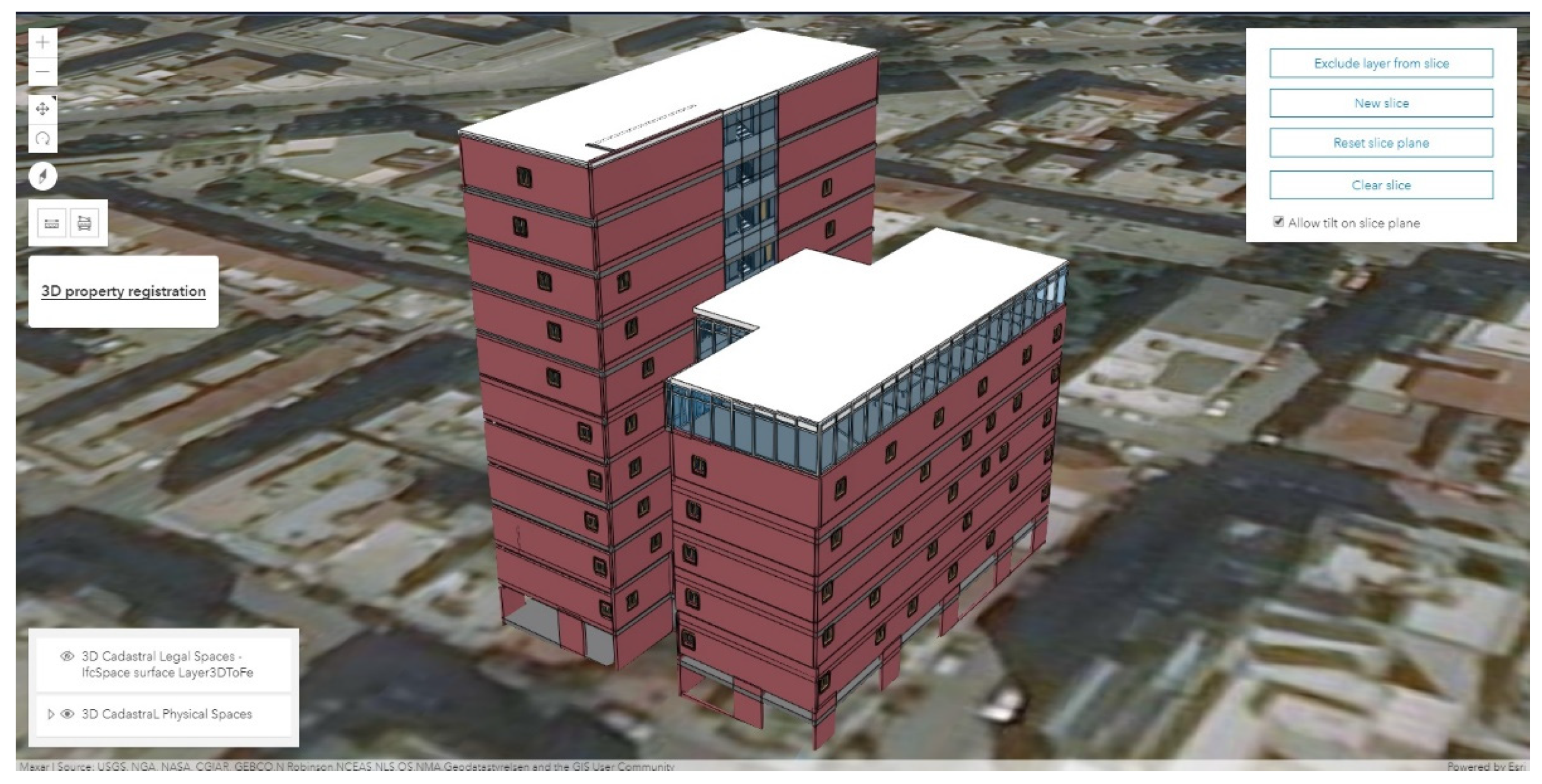
An open-source, web-based application developed by the authors was updated and is presented in [55] (Figure 2). The technical structure of the application allows for the integration of BIM/IFC data into a GIS environment, enabling the collection, visualization, storage, and update of 3D cadastral data based on the LADM standard. The application is easy to use, which enables it to be used by non-professionals. The physical cadastral spaces are presented in Level of Detail 4 (LoD4), while legal cadastral spaces are presented in LoD1, defining the full extent of the declared RRRs. The application enables the user to navigate through the 3D scene, formed from BIM data, in order to be oriented and be able to identify his/her property in the model. The displayed scene simulates the real world using a Digital Terrain Model (DTM) provided by the ESRI. For the development of the web-based application, the following set of software tools was utilized: (i) the web development environment of CodePen [56]; (ii) the ArcGIS API for JavaScript 4.18 of the ESRI, adding the function of ArcGIS to the application via libraries with a wide variety of methods and functions; (iii) the HTML and JavaScript programming languages; and (iv) the Server of ArcGIS Online (the ESRI cloud) for the storage and management of data [55]. It is noted that the selection of the ESRI product consists of only a first attempt at the implementation of our approach. Other open-source platforms for software applications could also be utilized.
The user interface represents the 3D building scene and provides a set of functional tools enabling the user to move throughout the scene, zoom in/out, and proceed with 3D registration by utilizing several data manipulation tools (Figure 3). More specifically, the developed application provides the following tools: (i) a layer management tool allowing the user to enable and disable a building’s layers presented in LoD1 or LoD4 in order to identify his/her property in the BIM; (ii) a 3D measurement tool enabling the user to measure the length and calculate the area on/of 3D objects; (iii) a building slicing tool allowing the user to create vertical and horizontal slices, revealing information about the building’s interior spaces; and (iv) an editor tool enabling the user to select his/her property in the BIM, which is presented in LoD1—where the property is presented as a solid entity of a single ownership—and insert all the necessary descriptive cadastral information about his/her rights. The web application may be utilized both for the creation of new registrations as well as for the submission of potential changes in the declared property rights (such as land/property use). Once the user enters all the necessary cadastral information, he/she may submit the declarations, updating with new records the LADM-based cadastral database. Thus, this process results in the creation of an up-to-date database, which may be further processed by the cadastral agency in order to proceed with the necessary evaluation and control of the submitted data.
4. Practical Experiment
To examine the potential and function of the proposed technical solution, a test implementation was conducted in a densely structured urban area of Athens, Greece. As the spatial background, a building block containing several multi-storey buildings was utilized (Figure 4). In this section, the necessary pre-processing steps enabling the insertion of the BIM into a GIS system, and therefore its integration into the LADM database and the developed cadastral web application, are presented. Next, the test implementation is described, and the initial results of the proposed crowdsourced approach are presented.
4.1. Pre-Processing Methodology
For this particular investigation, 3D building models in LoD3, available from a previously successfully completed project conducted by a research team of the National Technical University of Athens, was utilized [44]. Stereo-pairs of aerial images, terrestrial images, and ground control points were utilized through a combined pipeline for the generation of the 3D building models [44]. Furthermore, georeferenced floor plans were utilized for the creation of the BIM of a new building/construction in the studied area. The Autodesk Revit software was utilized for the generation of the BIM from the georeferenced floor plans, while the IFC standard was used in order to translate the BIM’s 3D spatial information into the ArcGIS platform. In the first step, the physical spaces were created in LoD4, describing the real characteristics of the buildings in detail. Then, the legal spaces were created utilizing the Area and Schedule function of Revit, enabling the identification of the 2D boundaries of each 3D legal space and the insertion of the necessary semantic information concerning the property’s RRRs, respectively. Finally, the created 2D spaces were matched with the IfcSpace entity in the exported IFC model, providing the 3D legal spaces. It is noted that the identification of the different types of legal objects is outside of the scope of this study. The management and definition of the different types of legal spaces and the proper placement of the legal boundaries (e.g., the middle of the wall) remain under investigation. In this study, we assumed that the legal spaces are correctly defined and we focused on the evaluation and assessment of the proposed technical framework regarding the submission of the cadastral information by the citizens/rights holders.
In the next step, the IFC model was imported into the ArcGIS Pro environment, enabling the further manipulation of the BIM for GIS/cadastral purposes. ArcGIS Pro’s quick import tool from the Data Interoperability Toolbox was utilized in order to import the generated IFC model into an ArcGIS file geodatabase, making the BIM’s spaces available for loading into the project. The generated geodatabase refers to the Greek Grid (ESPG: 2100) Projected Coordinate Reference System (PCRS), which is the PCRS of the used floor plans. However, the 3D scene of ArcGIS Pro refers to WGS84, which is the Geographic Coordinate Reference System (GCRS). Thus, the generated database had to be converted to WGS84 utilizing the Batch Project tool of ArcGIS Pro.
Although the coordinates of the “survey point” and the orientation of the BIM through the identification of the “true North” were defined in Revit, the IFC model was not correctly positioned in 3D space. In the context of BIM–GIS integration, geo-referencing BIM models can be problematic and constitutes a major issue in practice. For this particular study, the IFC2x3 version was utilized. Although this version embeds spatial reference information, mismatches may occur when importing the model to a GIS environment [57,58]. However, this problem was solved in the IFC4 version by introducing a new entity that includes and maintains all the necessary elements for the geo-reference of the model. The IFC4 version is newly emerging but may be utilized and tested for future research in this field.
The model was horizontally aligned close to its correct position with a fixed offset of 18 cm, while its vertical alignment was incorrect, making it appear to be submerged in the ground. To overcome this problem, the model was moved to its correct horizontal position utilizing the editing tools of ArcGIS Online. Subsequently, the elevation of the features of each generated feature class was set to “Relative to ground” in order for the features to appear at their correct height. Subsequently, new feature classes with the correct elevation were created utilizing the “Layer 3d To Feature Class” tool. It is noted that although the final model appears in its correct position horizontally, some ambiguities regarding its vertical alignment remain. This is mainly due to the used DTM, which in our study area appears at a higher altitude than in the real world. The result of this mismatch is that the ground floor of the building appears to be below the surface of the ground. However, this problem can be solved by using a more up-to-date and accurate DTM. Nevertheless, the final result is satisfactory for the purpose of this research.
Once the correct geodatabase was generated, the IfcSpace entity was connected to the Spaces class of the developed LADM-based geodatabase, which was enriched with the necessary geometric information concerning the cadastral legal spaces. By manipulating the generated geodatabase through the developed web application, the collection of the required semantic information concerning the property’s RRRs is feasible.
4.2. Test Implementation
Once the pre-processing steps were completed, the test implementation started. For research purposes, a team of students at the School of Rural and Surveying Engineers, National Technical University of Athens (NTUA), were assumed to be rights holders and proceeded with the 3D cadastral registration of multiple overlapping property units, including in one building of the studied area. The main objective of this experiment was to investigate the functionality of the proposed technical framework and provide some conclusions regarding its perspectives.
As a first step, the team of volunteers were trained regarding the functions of the web application by a member of our research team with the role of team leader. After the completion of this phase, the cadastral registration process was started. Each volunteer undertook the responsibility of identifying specific property units in the BIM and declaring the necessary information through the developed web application. For this experiment, the collected data included the property entity/volumetric object from the BIM that corresponded to the studied property unit; the descriptive information about the rights holder (first name, last name, and type of right); and the property unit (address, area code, and use).
Each volunteer was familiarized with the developed application and was navigated through the 3D building scene, aiming to identify the desired properties. During this process, the users of the web application were able to view both the structural and realistic characteristics of the building by enabling the LoD4 layer through the layer management tab located on the bottom left side of the developed interface. By viewing the realistic model of the 3D world, users recognized their properties faster. Additionally, the volunteer/user utilized the tools provided by the web application in order to measure the building’s characteristics (through measurement tools) or create vertical and horizontal slices of the BIM (through the building slicing tool) to verify the location of his/her property. Once the volunteer/user identified the desired property unit, he/she disabled LoD4 and enabled the LoD1 layer, through the layer management tab, and selected the respective property volume. By clicking on the BIM at the position that he/she assumed that his/her property was located, the 3D volume presenting the legal space where the RRRs are assigned was highlighted. Then, the insertion of the required cadastral information was done by utilizing the editor tool. By selecting the editor tool, a drop-down list appeared, enabling the insertion of data. Once the volunteers collected the required data, they submitted their declarations, which were stored in the cloud of ArcGIS Online, updating the system with the new records. An example of the described registration procedure is presented in Figure 5.
Finally, the registration procedure was completed by the volunteers. The use of the web application was easy, with the registration of each property accomplished in about 6–12 min (on average), depending on the location of the property in the BIM and the familiarity of the user with the web environment. The required cadastral data were collected successfully and stored in the cloud of ArcGIS Online. The initial results of the test implementation seem to be very promising; however, a more in-depth investigation is needed in order to highlight any weaknesses or problems regarding the proposed framework and the web application itself.
5. Discussion and Conclusions
With the rapid economic and social transformation over the last few years, several complex constructions with multidimensional overlapping property rights have emerged. The establishment of modern land administration systems able to manage various types of rights in a uniform, standardized, and reliable way, both above and below the land surface, is being pioneered. While this need has already been acknowledged, especially in densely populated areas, cadastral systems remain based on 2D maps. A simple, timely, and cost-effective solution is needed for the initial implementation of 3D cadasters. The utilization of the LADM standard in combination with innovative crowdsourcing techniques—for data acquisition—and the utilization of the available geospatial infrastructure of each country may constitute a potential solution, introducing a new era for both 2D and 3D land administration procedures. The proposed crowdsourced technical framework combines the current initiatives of the scientific community and provides an alternative approach to the initial implementation of 3D cadastral surveys by setting the basis for the timely implementation of a fit-for-purpose 3D cadaster.
To date, several interesting approaches regarding the implementation of 3D cadasters have been proposed by researchers. However, the implementation of 3D cadastral surveys based on traditional practices may lead to severe delays and increased costs, complicating the implementation of the 3D cadasters the European Union desires. As has been proven in previous stages of this research, 2D and 3D crowdsourced cadastral surveys enable the initial implementation of 3D cadastral systems in a timely and cost-effective manner, providing reliable and accurate results. However, the success of the crowdsourced surveys is based on the quality of the available registration basemap. The majority of the current crowdsourcing studies utilize recent orthophotos of the areas under cadastral survey or/and 2D floor plans (if they exist) as well as other systems, such as GPS and Bluetooth, in combination with innovative machine learning algorithms in order to provide an accurate input for cadastral surveys. Despite the relatively wide range of potential data sources for crowdsourced cadastral surveys, there are several other choices that should be investigated. The abovementioned geospatial resources may not be always available. However, our main interest is to categorize the available alternatives based on their potential accuracy and proceed with the best one.
The emergence of the BIM has produced a technological revolution, as it enables the integration of numerous threads concerning the different types of information used in construction into a single environment [44]. Thus, the need for paper-based documents, such as strata plan drawings, is either eliminated or reduced due to their being exchanged for digital documents and records. As BIMs consist of one of the most detailed and comprehensive object-oriented methods of modeling buildings, their utilization and potential (re)use may be of significant importance for the declaration of the physical and legal cadastral objects in a 3D cadaster. The visualization of real properties through BIMs, enriched with cadastral information, may provide a very useful registration background for the initial implementation of 3D cadastral surveys, mainly in urban areas. The integration of 3D digital models—such as building information modelling (BIM)—and 3D geographic information systems (GISs)—such as cadastral systems—have several capabilities in order to declare relevant data, represent physical and legal cadastral boundaries, and visualize complex buildings in detail. Thus, a better understanding of the property’s boundaries and the extent of the RRRs can be achieved, ensuring clarity and avoiding improper use and disputes among the rights holders [44]. A BIM’s usability is also empowered through the IFC standard, as it enables compatibility between architectural, engineering, and construction (AEC) activities and allows for the modeling, storing, and management of 3D building elements for multiple purposes in different platforms. Thus, a BIM may be utilized in order to integrate 3D building elements with 3D cadastral information, enabling interoperability among the involved parties.
The proposed LADM-based crowdsourced approach provides an alternative solution for the initial acquisition of standardized 3D cadastral information, utilizing the content of (existing) BIMs. The selection of a web application as the main data capturing tool uses citizens’ familiarity with smart devices and internet/web applications, which are intertwined with modern reality. With the utilization of BIMs, rights holders may have better supervision and a better understanding of 3D space and, therefore, the determination of the location of their property consists of a simple procedure. The developed web application enables the timely collection of the necessary data, with the registration of each property unit fluctuating between 6 and 12 min (on average). It is noted that the time required depends on the user’s ability to understand the function of the cadastral web application and his/her capacity to be oriented in the 3D virtual environment. However, as the test implementation demonstrated, BIM data provide a cost-effective solution that facilitates the cadastral registration procedure, providing a valuable visual representation of real properties and speeding up the implementation of a multi-purpose 3D Land Administration System (LAS).
This study focuses on the technical aspect of the crowdsourced solution while investigating the potential utilization of BIM data as an alternative data source. Through this experiment, it was shown that the proposed crowdsourced approach is able to provide an up-to-date LADM-based cadastral database, which in a later stage may be further processed and evaluated by a cadastral agency. The immediate acquisition of multiple types of information regarding buildings consists of a particularly important process, especially in the case of modern cities. Through the utilization of the proposed framework, rights holders may also, over time, submit changes concerning their properties, such as changes in use and ownership. Thus, the cadastral database may always be up to date and may provide a reliable source of information for a wide variety of applications.
The next step of this research will be to carry out a large-scale implementation of the proposed framework in order to investigate in detail the weaknesses of the proposed technical framework and to proceed with the necessary corrections. The definition of the various types of legal spaces and the proper placement of the legal boundaries (e.g., the middle of the wall) will be further investigated. Additionally, the developed web application is intended to be optimized since, for the time being, it remains in the beta version. Initially, it seems that 3D BIMs potentially can serve as important and detailed sources of data for such 3D spatial units. Several efforts have been made to enable a wider usage of BIM data in GIS projects. The ISO 19166 standard should provide professionals with a conceptual framework for potential transformations between BIMs and GISs, enlarging their application range [48]. So, it seems that there are significant opportunities for the utilization of BIMs in 3D cadasters as well as in other fields. However, there remain challenges to be further investigated and solved, including a common terminology and the lack of experts with deep knowledge of both domains.
Author Contributions
Conceptualization, M.G. and C.P.; Data curation, M.G., S.S., G.V. and M.-E.C.; Formal analysis, M.G. and C.P.; Investigation, M.G. and C.P.; Methodology, M.G. and C.P.; Project administration, M.G. and C.P.; Resources, S.S.; Software, M.G.; Supervision, M.G. and C.P.; Validation, M.G.; Visualization, M.G. and C.P.; Writing—original draft, M.G.; Writing—review & editing, M.G. and C.P. All authors have read and agreed to the published version of the manuscript.
Funding
This research received no external funding.
Data Availability Statement
The data presented in this study consist a part of a previously successfully completed 5DMuPLIS project conducted by a research team of the National Technical University of Athens. In addition, ΒΙΜ data available from M.-E. Cravaritis’ diploma thesis were used to create the registration background.
Acknowledgments
The contribution of Maria Gkeli to this research is part of her PhD dissertation, which is supported by the Onassis Foundation scholarship program and the Hellenic Foundation for Research and Innovation (H.F.R.I.).
Conflicts of Interest
The authors declare no conflict of interest.
References
- Enemark, S.; Bell, K.C.; Lemmen, C.; McLaren, R. Fit-for-Purpose Land Administration; International Federation of Surveyors: Frederiksberg, Denmark, 2014. [Google Scholar]
- Gkeli, M.; Potsiou, C.; Ioannidis, C. Design of a crowdsourced 3d cadastral technical solution. Int. Arch. Photogramm. Remote Sens. Spat. Inf. Sci. 2020, XLIII-B4-2020, 269–276. [Google Scholar] [CrossRef]
- Koeva, M.; Nikoohemat, S.; Oude Elberink, S.; Morales, J.; Lemmen, C.; Zevenberger, J. Towards 3D Indoor Cadastre Based on Change Detection from Point Clouds. Remote Sens. 2019, 11, 1972. [Google Scholar] [CrossRef] [Green Version]
- Stoter, J.E.; van Oosterom, P. Technological aspects of a full 3D cadastral registration. Int. J. Geogr. Inf. Sci. 2005, 19, 669–696. [Google Scholar] [CrossRef]
- Karki, S. 3D Cadastre Implementation Issues in Australia. Master’s Thesis, University of Southern Queensland, Toowoomba, Australia, 2013. [Google Scholar]
- Guo, R.; Luo, F.; Zhao, Z.; He, B.; Li, L.; Luo, P.; Ying, S. The Applications and Practices of 3D Cadastre. In Proceedings of the 4th International Workshop on 3D Cadastres, Dubai, United Arab Emirates, 9–11 November 2014; pp. 299–312. [Google Scholar]
- Vandysheva, N.; Tikhonov, V.; van Oosterom, P.; Stoter, J.; Ploeger, H.; Wouters, R.; Penkov, V. 3D Cadastre Modelling in Russia. In Proceedings of the FIG Working Week, Marrakech, Morocco, 18–22 May 2011; p. 19. Available online: https://www.fig.net/resources/proceedings/fig_proceedings/fig2011/papers/ts01c/ts01c_vandysheva_tikhonov_et_al_4967.pdf (accessed on 15 May 2020).
- Vandysheva, N.; Ivanov, A.; Pakhomov, S.; Spiering, B.; Stoter, J.; Zlatanova, S.; van Oosterom, P. Design of the 3D Cadastre Model and Development of the Prototype in the Russian Federation. In Proceedings of the 2nd International Workshop on 3D Cadastres, Delft, The Netherlands, 16–18 November 2011; pp. 355–375. [Google Scholar]
- Stoter, J.; van Oosterom, P.; Ploeger, H. The phased 3D cadastre implementation in the Netherlands. In Proceedings of the 3rd International Workshop on 3D Cadastres, Shenzhen, China, 25–26 October 2012; pp. 201–218. [Google Scholar]
- Stoter, J.; Ploeger, H.; Roes, R.; van der Riet, E.; Biljecki, P.; Ledoux, H. First 3D Cadastral Registration of Multi-level Ownerships Rights in the Netherlands. In Proceedings of the 5th International FIG 3D Cadastre Workshop, Athens, Greece, 18–20 October 2016; pp. 491–504. [Google Scholar]
- Thompson, R.J.; van Oosterom, P.J.M.; Soon, K.H.; Priebbenow, R. A Conceptual Model Supporting a Range of 3D Parcel Representations through all Stages: Data Capture, Transfer and Storage. In Proceedings of the FIG Working Week, Christchurch, New Zealand, 30 April–1 May 2016; Available online: www.fig.net/resources/proceedings/2016/2016_3dcadastre/3Dcad_2016_02.pdf.pdf (accessed on 1 March 2021).
- Kitsakis, D.; Paasch, J.; Paulsson, J.; Navratil, G.; Vucic, N.; Karabin, M.; Carneiro, A.T.; El-Mekawy, M. 3D Real Property Legal Concepts and Cadastre: A Comparative Study of Selected Countries to Propose a Way Forward (Overview Report). In Proceedings of the 3D Cadastre Workshop 2016, Athens, Greece, 18–20 October 2016. [Google Scholar]
- Atazadeh, B.; Rajabifard, A.; Kalantari, M. Connecting LADM and IFC Standards—Pathways towards an Integrated Legal-Physical Model. In Proceedings of the 7th International FIG Workshop on the Land Administration Domain Model, Zagreb, Croatia, 12–13 April 2018; pp. 89–102. [Google Scholar]
- Atazadeh, B.; Rajabifard, A.; Zhang, Y.; Barzegar, M. Querying 3D Cadastral Information from BIM Models. ISPRS Int. J. Geo-Inf. 2019, 8, 329. [Google Scholar] [CrossRef] [Green Version]
- Basiouka, S.; Potsiou, C. VGI in Cadastre: A Greek experiment to investigate the potential of crowdsourcing techniques in Cadastral Mapping. Surv. Rev. 2012, 44, 153–161. [Google Scholar] [CrossRef]
- Gkeli, M.; Potsiou, C.; Ioannidis, C. A technical solution for 3D crowdsourced cadastral surveys. Land Use Policy 2020, 98, 104419. [Google Scholar] [CrossRef]
- Mourafetis, G.; Apostolopoulos, K.; Potsiou, C.; Ioannidis, C. Enhancing Cadastral Survey by Facilitating Owners’ Participation. Surv. Rev. 2015, 47, 316–324. [Google Scholar] [CrossRef]
- Apostolopoulos, K.; Geli, M.; Petrelli, P.; Potsiou, C.; Ioannidis, C. A new model for Cadastral Surveying using Crowdsourcing. Surv. Rev. 2018, 50, 122–133. [Google Scholar] [CrossRef]
- Gkeli, M.; Apostolopoulos, K.; Mourafetis, G.; Ioannidis, C.; Potsiou, C. Crowdsourcing and mobile services for a fit-for-purpose Cadastre in Greece. In Proceedings of the Fourth International Conference on Remote Sensing and Geoinformation of the Environment (RSCy2016), SPIE; International Society for Optics and Photonics: Bellingham, WA, USA, 2016; Volume 9688, p. 968817. [Google Scholar] [CrossRef]
- Potsiou, C.; Paunescu, C.; Ioannidis, C.; Apostolopoulos, K.; Nache, F. Reliable 2D Crowdsourced Cadastral Surveys: Case Studies from Greece and Romania. ISPRS Int. J. Geo-Inf. 2020, 9, 89. [Google Scholar] [CrossRef] [Green Version]
- Mourafetis, G.; Potsiou, C. IT Services and Crowdsourcing in Support of the Hellenic Cadastre: Advanced Citizen Participation and Crowdsourcing in the Official Property Registration Process. ISPRS Int. J. Geo-Inf. 2020, 9, 190. [Google Scholar] [CrossRef] [Green Version]
- Gkeli, M.; Ioannidis, C.; Potsiou, C. Review of the 3D Modelling Algorithms and Crowdsourcing Techniques-An Assessment of their Potential for 3D Cadastre. In Proceedings of the FIG Working Week 2017—“Surveying the World of Tomorrow–From Digitalisation to Augmented Reality”, Helsinki, Finland, 29 May–2 June 2017; p. 23. [Google Scholar]
- Gkeli, M.; Ioannidis, C.; Potsiou, C. 3D Modelling Algorithms and Crowdsourcing Techniques. Coord. Mag. 2017, 13, 7–14. [Google Scholar]
- Gkeli, M.; Ioannidis, C.; Potsiou, C. The potential use of VGI for 3D cadastre surveys. Coord. Mag. 2017, 13, 14–19. [Google Scholar]
- Gkeli, M.; Ioannidis, C.; Potsiou, C. VGI in 3D Cadastre: A Modern Approach. In Proceedings of the FIG Commission 3 Annual Workshop “Volunteered Geographic Information: Emerging Applications in Public Science”, Lisbon, Portugal, 27–30 November 2017; p. 21. [Google Scholar]
- Gkeli, M.; Potsiou, C.; Ioannidis, C. LADM-based Crowdsourced 3D Cadastral Surveying—Potential and Perspectives. In Proceedings of the 6th International FIG Workshop on 3D Cadastres, Delft, The Netherlands, 2–4 October 2018. [Google Scholar]
- Gkeli, M.; Potsiou, C.; Ioannidis, C. Crowdsourced 3D cadastral surveys: Looking towards the next 10 years. J. Geogr. Syst. 2019, 21, 61–87. [Google Scholar] [CrossRef]
- Cetl, V.; Ioannidis, C.; Dalyot, S.; Doytsher, Y.; Felus, Y.; Haklay, M.; Mueller, H.; Potsiou, C.; Rispoli, E.; Siriba, D. New Trends in Geospatial Information: The Land Surveyors Role in the Era of Crowdsourcing and VGI; FIG Publication No 73; International Federation of Surveyors (FIG): Copenhagen, Denmark, 2019. [Google Scholar]
- Oldfield, J.; Van Oosterom, P.; Beetz, J.; Krijnen, T. Working with Open BIM Standards to Source Legal Spaces for a 3D Cadastre. ISPRS Int. J. Geo-Inf. 2017, 6, 351. [Google Scholar] [CrossRef] [Green Version]
- Lemmen, C.; van Oosterom, P. 3D Cadastres. Comput. Environ. Urban. Syst. (CEUS) 2003, 27, 337–343. [Google Scholar] [CrossRef]
- Kitsakis, D.; Dimopoulou, E. 3D cadastres: Legal approaches and necessary reforms. Surv. Rev. 2014, 46, 322–332. [Google Scholar] [CrossRef]
- van Oosterom, P. Research and development in 3D cadastres. Comput. Environ. Urban. Syst. 2013, 40, 1–6. [Google Scholar] [CrossRef]
- Guo, R.; Li, L.; Ying, S.; Luo, P.; He, B.; Jiang, R. Developing a 3D cadastre for the administration of urban land use: A case study of Shenzhen, China. Comput. Environ. Urban. Syst. 2013, 40, 46–55. [Google Scholar] [CrossRef]
- Ying, S.; Guo, R.; Li, L.; Van Oosterom, P.; Stoter, J. Construction of 3D Volumetric Objects for a 3D Cadastral System. Trans. GIS 2015, 19, 758–779. [Google Scholar] [CrossRef]
- Lee, B.M.; Kim, T.J.; Kwak, B.Y.; Lee, Y.H.; Choi, J. Improvement of the Korean LADM country profile to build a 3D cadastre model. Land Use Policy 2015, 49, 660–667. [Google Scholar] [CrossRef]
- Janečka, K.; Souček, P. A country profile of the Czech Republic based on an LADM for the Development of a 3D Cadastre. ISPRS Int. J. Geo-Inf. 2017, 6, 50143. [Google Scholar] [CrossRef]
- Lemmen, C.; van Oosterom, P.; Bennett, R. The land administration domain model. Land Use Policy 2015, 49, 535–545. [Google Scholar] [CrossRef] [Green Version]
- Ying, S.; Guo, R.; Yang, J.; He, B.; Zhao, Z.; Jin, F. 3D space shift from CityGML LoD3-based multiple building elements to a 3D volumetric object. ISPRS Int. J. Geo-Inf. 2017, 6, 17. [Google Scholar] [CrossRef] [Green Version]
- Thompson, R.J.; van Oosterom, P.; Soon, K.H. LandXML encoding of mixed 2D and 3D survey plans with multi-level topology. ISPRS Int. J. Geo-Inf. 2017, 6, 171. [Google Scholar] [CrossRef] [Green Version]
- Atazadeh, B.; Kalantari, M.; Rajabifard, A.; Ho, S. Modelling building ownership boundaries within BIM environment: A case study in Victoria, Australia. Comput. Environ. Urban. Syst. 2017, 61, 24–38. [Google Scholar] [CrossRef]
- Rajabifard, A.; Atazadeh, B.; Kalantari, M. BIM and Urban Land Administration; Taylor & Francis, CRC Press: Boca Raton, FL, USA, 2019; ISBN 1138491683. [Google Scholar]
- Stoter, J.; Ho, S.; Biljecki, F. Considerations for a contemporary 3D Cadastre for our times. Int. Arch. Photogramm. Remote Sens. Spat. Inf. Sci. 2019, XLII-4/W15, 81–88. [Google Scholar] [CrossRef] [Green Version]
- Van Oosterom, P.; Lemmen, C.; Thompson, R.; Janecka, K.; Zlatanova, S.; Kalantari, M. 3D cadastral information modelling. In Best Practices 3D Cadastres—Extended Version; FIG Publication: Copenhagen, Denmark, 2018. [Google Scholar]
- Barzegar, M.; Rajabifard, A.; Kalantari, M.; Atazadeh, B. An IFC-based database schema for mapping BIM data into a 3D spatially enabled land administration database. Int. J. Digit. Earth 2021, 14, 736–765. [Google Scholar] [CrossRef]
- Oldfield, J.; Oosterom, P.; Quak, W.; Veen, J.; Beetz, J. Can Data from BIMs be Used as Input for a 3D Cadastre? In Proceedings of the 5th International FIG 3D Cadastre Workshop, Athens, Greece, 18–20 October 2016; pp. 199–214. [Google Scholar]
- Alattas, A.; Van Oosterom, P.; Zlatanova, S. Deriving the Technical Model for the Indoor Navigation Prototype based on the Integration of IndoorGML and LADM Conceptual Model. In Proceedings of the 7th International FIG Workshop on the Land Administration Domain Model, Zagreb, Croatia, 12–13 April 2018; pp. 245–268. [Google Scholar]
- Sun, J.; Mi, S.; Olsson, P.; Paulsson, J.; Harrie, L. Utilizing BIM and GIS for Representation and Visualization of 3D Cadastre. ISPRS Int. J. Geo-Inf. 2019, 8, 503. [Google Scholar] [CrossRef] [Green Version]
- Janecka, K. Standardization supporting future smart citiesa case of BIM/GIS and 3D Cadastre. GeoScape 2019, 13, 106–113. [Google Scholar] [CrossRef] [Green Version]
- Andrianesi, D.E.; Dimopoulou, E. An integrated BIM-GIS platform for representing and visualizing 3d cadastral data. ISPRS Ann. Photogramm. Remote Sens. Spat. Inf. Sci. 2020, VI-4/W1-2020. [Google Scholar] [CrossRef]
- Basiouka, S.; Potsiou, C. The volunteered geographic information in cadastre: Perspectives and citizens’ motivations over potential participation in mapping. Geo J. 2014, 79, 343–355. [Google Scholar] [CrossRef]
- Potsiou, C.; Doulamis, N.; Bakalos, N.; Gkeli, M.; Ioannidis, C. Indoor localization for 3d mobile cadastral mapping using machine learning techniques. ISPRS Ann. Photogramm. Remote Sens. Spat. Inf. Sci. 2020, VI-4/W1-2020, 159–166. [Google Scholar] [CrossRef]
- Ellul, C.; de Almeida, J.P.; Romano, R. Does coimbra need a 3d cadastre? Prototyping a crowdsourcing app as a first step to finding out. ISPRS Ann. Photogramm. Remote Sens. Spatial Inf. Sci. 2016, IV-2/W1, 55–62. [Google Scholar] [CrossRef] [Green Version]
- Williamson, I.; Rajabifard, A.; Kalantari, M.; Wallace, J. AAA Land Information: Accurate, Assured and Authoritative. In Proceedings of the 8th FIG Regional Conference, Montevideo, Uruguay, 26–29 November 2012; Available online: www.oicrf.org/documents/40950/43224/AAA+land+information+accurate+assured+and+authoritative%281%29.pdf/6aba089c-e3fc-5f30–3f64-eef3a18add8b (accessed on 1 March 2020).
- Molendijk, M.; Dukon, T.; Lemmen, C.; Morales, J.; Endo, V.; Rodriguez, S.; Dueñas, J.; Sanchez, I.; Spijkers, P.; Unger, E.; et al. Land and Peace in Colombia: FFP Methodology for Field Data Collection and Data Handling. In Proceedings of the World Bank Land and Poverty Conference 2018, Washington DC, USA, 19–23 March 2018. [Google Scholar]
- Gkeli, M.; Potsiou, C.; Ioannidis, C. BIM data as Input to 3D Crowdsourced Cadastral Surveying—Potential and Perspectives. In Proceedings of the FIG e-Working Week 2021, Virtually, Leiden, The Netherlands, 20–25 June 2021. [Google Scholar]
- CodePen. Available online: https://codepen.io/ (accessed on 28 January 2021).
- Ioannidis, C.; Verykokou, S.; Soile, S.; Potsiou, C. 5D Multi-Purpose Land Information System. In Proceedings of the Eurographics Workshop on Urban Data Modelling and Visualisation, Delft, The Netherlands, 23 November 2015; pp. 19–24. [Google Scholar] [CrossRef]
- Zhu, J.; Wu, P. A Common Approach to Geo-Referencing Building Models in Industry Foundation Classes for BIM/GIS Integration. ISPRS Int. J. Geo-Inf. 2021, 10, 362. [Google Scholar] [CrossRef]
Figure 1.
Conceptual schema of the developed data model.

Figure 2.
Overview of the user interface of the developed web application.

Figure 3.
Top row (left to right): the application’s interface; and the layer management tool;. Middle row (left to right) the 3D length measurement tool; and the 3D area and perimeter measurement tool;. Bottom row (left to right): the building slicing tool; and the editor tool.
Figure 3.
Top row (left to right): the application’s interface; and the layer management tool;. Middle row (left to right) the 3D length measurement tool; and the 3D area and perimeter measurement tool;. Bottom row (left to right): the building slicing tool; and the editor tool.

Figure 4.
The aerial photo of the test area (left) and the 3D models of the studied and neighboring buildings (right).
Figure 4.
The aerial photo of the test area (left) and the 3D models of the studied and neighboring buildings (right).

Figure 5.
Example of the registration process through the developed web application, including: (first row) the identification of the desired property; (second row) the property selection; (third row) the insertion of the necessary information concerning the rights holder; and (fourth row) the building.

Publisher’s Note: MDPI stays neutral with regard to jurisdictional claims in published maps and institutional affiliations. |
© 2021 by the authors. Licensee MDPI, Basel, Switzerland. This article is an open access article distributed under the terms and conditions of the Creative Commons Attribution (CC BY) license (https://creativecommons.org/licenses/by/4.0/).
Share and Cite
MDPI and ACS Style
Gkeli, M.; Potsiou, C.; Soile, S.; Vathiotis, G.; Cravariti, M.-E. A BIM-IFC Technical Solution for 3D Crowdsourced Cadastral Surveys Based on LADM. Earth 2021, 2, 605-621. https://0-doi-org.brum.beds.ac.uk/10.3390/earth2030035
AMA Style
Gkeli M, Potsiou C, Soile S, Vathiotis G, Cravariti M-E. A BIM-IFC Technical Solution for 3D Crowdsourced Cadastral Surveys Based on LADM. Earth. 2021; 2(3):605-621. https://0-doi-org.brum.beds.ac.uk/10.3390/earth2030035
Chicago/Turabian StyleGkeli, Maria, Chryssy Potsiou, Sofia Soile, Giorgos Vathiotis, and Maria-Eleni Cravariti. 2021. "A BIM-IFC Technical Solution for 3D Crowdsourced Cadastral Surveys Based on LADM" Earth 2, no. 3: 605-621. https://0-doi-org.brum.beds.ac.uk/10.3390/earth2030035