
The Quest for Proximity: A Systematic Review of Computational Approaches towards 15-Minute Cities


1
O’More College of Architecture and Design, Belmont University, Nashville, TN 37212, USA
2
Graduate Program in Architecture and Urban Design, Federal University of Paraiba, João Pessoa 58051-900, PB, Brazil
*
Author to whom correspondence should be addressed.
Architecture 2023, 3(3), 393-409; https://0-doi-org.brum.beds.ac.uk/10.3390/architecture3030021
Submission received: 27 April 2023
/
Revised: 28 May 2023
/
Accepted: 29 June 2023
/
Published: 3 July 2023
Abstract
:How can computational tools support the proposition of 15-minute cities? This paper examines the implementation of computer-aided approaches that support the analysis and proposition of urban areas where residents can access all their basic needs within a 15-minute walk, bike ride, or public transportation ride—the ultimate goal of a 15-minute city. Although this concept has gained significant attention as a sustainable and equitable urban development model, more efficient implementations require complex spatial and temporal analysis. At the same time, computational approaches such as those within the generative and parametric logic can utilize algorithms to create and test design solutions quickly and efficiently, allowing designers to address a variety of scenarios and options for producing more walkable, integrated, and resilient urban environments. Exploring a systematic review of the scientific literature (n = 244 peer-reviewed empirical studies) on Scopus and Web of Science databases, this paper synthesizes approaches to support the analysis and design of 15-minute cities, emphasizing the use of computer-aided techniques. The work contributes to developing a knowledge base on computational tools for 15-minute cities, highlighting their strengths, limitations, and potential for further development.
1. Introduction
Modern cities, in their majority, are designed for automobiles, not pedestrians. Environmentally friendly options such as walking, biking, and public transit are often unreliable, inaccessible, or there is no infrastructure for the public to take advantage of these transportation modalities. The car-oriented legacy of organizing cities has resulted in significant issues, such as air pollution, traffic congestion, reduced accessibility to amenities, sedentary lifestyles, longer commute times, and fragmentation of communities. In addition, urban spaces designed this way can also increase crime rates and discomfort for residents who feel threatened by excessive traffic and potential traffic violations [1].
According to the United Nations, transportation emissions account for around one-quarter of greenhouse gas emissions worldwide, the largest source of energy-related emissions for 45% of countries and the second largest for the other 55% of nations [2]. The World Health Organization reported that air pollution causes 7 million premature deaths a year [3], with death causes that vary from ischemic heart disease, stroke, and lung cancer to acute lower respiratory infections in children. In the United States, according to data from the US Census Bureau [4], the duration of the average one-way commute increased to a new high of 27.6 min in 2019, and a record 9.8% of commuters reported daily one-way commutes of at least 1 h.
The emergence of the COVID-19 pandemic, in turn, prompted the need for creative and innovative ways for cities to pursue their economic operations while imposing rigorous health standards, providing one unexpected increase in interest toward achieving sustainability in cities [5]. The emergence of this pandemic revealed cities’ vulnerability in their current configuration and the need for a radical rethinking, where inventive measures must be tailored to ensure that urban residents can cope and continue their essential activities [6,7,8]. Transitioning towards more accessible, connected, and inclusive urban environments is crucial for building safer, more resilient, sustainable, and inclusive cities, as portrayed in the United Nations’ Sustainable Development Goal 11.
The 15-minute city (FMC) concept consists of creating cities where all essential amenities, services, and opportunities are accessible within a 15-minute walk, bike ride, or public transportation ride from people’s homes. Its core principle is to develop compact and connected urban areas prioritizing human-scale infrastructure and public space while reducing the need for long commutes, promoting active transportation, and fostering local communities. The concept was first introduced by Carlos Moreno [5] and has gained popularity in recent years as a response to urban sprawl and its associated problems, such as traffic congestion, air pollution, and social isolation.
Many cities worldwide are embracing the idea of FMC—or similar—as a framework for more inclusive and resilient communities better equipped to face future challenges, such as climate change and pandemics. However, implementing this “chrono-urbanism” logic efficiently demands exploring complex spatial and temporal urban features, such as the location of existing services and amenities, the street network configuration, and the frequency of public transportation services. These features require managing vast amounts of data and performing complex and incremental calculations that computational tools can facilitate or even make possible. For instance, accessibility, a key principle for FMC, cannot be abstracted from other attributes of the urban environment that directly impact the perceived quality of life. Computational approaches have the potential to support the management of several metrics.
Parametric and generative tools, for instance, can support urban design approaches to address spatial and temporal analysis for FMCs since they use algorithms to generate, manipulate, and assess a large number of potential design options within a timeframe that conventional systems—even some computer-aided ones—cannot. This framework allows planners and policymakers to explore large sets of possible designs and identify the most effective spatial configurations.
The main objective of this paper is to develop a comprehensive overview of the use of computational tools to support the analysis and design of 15-minute cities using a systematic literature review. To that end, our systematic literature review considered papers exploring FMC regardless of if they are using computational tools or not so that we could verify which techniques are present in non-computational works and the possibilities of improvement in the most applied techniques. Thus, the literature review was guided by the following research questions: (i) To which extent are computational tools being used within the urban design scope (In the context of this research, we are interested in research that focuses on the urban design scope, or that is oriented to interdisciplinary issues related to urban design. Thus, papers that are primarily connected to other research fields but directly relate to urban design were included in this literature review)? (ii) what computational tools are being used to analyze and design FMCs? and (iii) how these tools are being utilized to support design and analysis. This work broadly synthesizes analysis and design approaches related to the FMC concept, emphasizing computational techniques while focusing on the following analytical categories: (i) the year of publication; (ii) the closest related knowledge field; (iii) the employed methodology; (iv) the nature of the approach used; (v) the scale of addressed samples; (vi) the type of samples; (vii) the related country of the studies; (viii) the use of computational tools in the studies; (ix) the use of objective/numerical parameters in the studies; and (x) the employment of generative design in the works.
2. Background
2.1. The 15-Minute City Concept: Origins, Main Principles, and Primary Features
Although the term 15-minute city is new, its basic principles are not necessarily so. The origins of the FMC concept can be traced back to a few different sources and ideas, and one of the key influences is the notion of the compact city, which advocates dense and mixed-use urban development where residential, commercial, and recreational activities are integrated within the same urban area. This idea has been promoted by urban planners and architects for several decades, spanning from Cerda’s urbanism [9], Rob Krier’s studies of the typology of public spaces [10], to Jane Jacobs’ work [11] as a way to reduce urban sprawl, minimize commuting distances, and enhance the overall quality of life in cities. Concentrating buildings and activities in a compact area makes it easier to provide infrastructure and services efficiently, reducing the need for long commutes and enhancing accessibility. In summary, the main features of FMC aim to enhance livability, sustainability, and social inclusiveness. Below are some key elements typically associated with the 15-minute city concept:
- Mixed-Use Development: The FMC promotes the integration of different land uses within proximity. Residential areas combine commercial, educational, healthcare, cultural, and recreational facilities, reducing the need for long-distance travel and enabling residents to access essential services nearby.
- Proximity to Amenities: Amenities within walking or cycling distance are crucial in a 15-minute city. This includes grocery stores, pharmacies, schools, parks, healthcare facilities, libraries, community centers, and other daily necessities. Residents can save time and reduce reliance on cars for routine tasks by having these amenities nearby.
- Compact and Pedestrian-Friendly Design: The physical layout of the FMC emphasizes walkability and encourages active transportation. It features well-designed sidewalks, pedestrian-friendly streets, and dedicated cycling infrastructure. Compact urban forms with shorter block sizes and interconnected street networks promote ease of movement and minimize travel distances.
- Accessible Public Transportation: While the FMC emphasizes walking and cycling, it also recognizes the importance of public transportation. Efficient and accessible public transit systems, including buses, trams, or subways, complement the city’s walkability, extending residents’ reach beyond the immediate neighborhood when necessary.
- Green Spaces and Public Realm: The presence of green spaces, such as parks, gardens, and public squares, is integral to the FMC. These areas provide opportunities for recreation, relaxation, and social interaction. Green infrastructure helps improve air quality, mitigate heat island effects, and contribute to well-being.
- Local Job Opportunities: The concept of FMC acknowledges the importance of local employment. Promoting a mix of residential and commercial spaces seeks to create job opportunities within or near neighborhoods. This reduces commuting distances and supports local economic development.
- Community Engagement and Social Inclusion: The FMC fosters community engagement and social cohesion. It encourages the involvement of residents in neighborhood decision-making processes, promotes local businesses, and supports a diverse mix of housing options to accommodate different income levels, fostering inclusivity and social interaction.
- Sustainability and Environmental Considerations: The 15-minute city aligns with sustainable development principles. Reducing reliance on cars and shortening travel distances aims to decrease greenhouse gas emissions, promote active transportation, and improve air quality. Integrating renewable energy sources, energy-efficient buildings, and sustainable infrastructure further contributes to environmental sustainability.
While these features are commonly associated with the FMC, it is essential to note that the specific implementation may vary based on the context and priorities of each urban area. The concept provides a framework for urban planning that promotes accessibility, convenience, and high quality of life for residents within a localized and self-sufficient urban environment. However, due consideration should be paid to the design of its components to limit or make it as difficult as possible for different socially infective events that result in residents’ negative perceptions to occur since if some spaces are perceived as unsafe, they implicitly encourage using cars, even for short distances [12].
2.2. Computational Tools for Urban Design and Planning: A Brief Panorama
Computational tools have revolutionized the field of urban design, offering innovative ways to analyze, visualize, and optimize urban environments [13,14,15,16,17]. These tools have significantly transformed the planning and design processes state-of-the-art, enabling more informed decision-making and enhancing the efficiency and effectiveness of urban design practices.
One key area where computational tools have significantly impacted is data analysis and modeling. Urban designers now have access to vast amounts of data, ranging from population demographics to transportation patterns and environmental factors. Computational tools allow for integrating and analyzing these datasets, providing valuable insights into the complex dynamics of urban systems. This data-driven approach enables designers to make more informed decisions, identify patterns and trends, and assess the potential impacts of design choices.
Furthermore, computational tools have contributed to advancing parametric design and generative modeling techniques. Parametric design uses algorithms and mathematical parameters to create and manipulate design elements. This approach enables designers to explore various options, iterate rapidly, and optimize designs based on predefined criteria. The generative design takes this further by automatically using algorithms to generate design alternatives based on specific rules and parameters. These tools empower designers to explore innovative and optimized design solutions while considering various constraints and objectives.
Several authors in recent years presented parametric tools or approaches addressing principles and metrics embedded in FMC, although not directly approaching the concept in its completeness: Sevtsuk and Mekonnen [18] introduced the Urban Network Analysis (UNA), a set of tools for modeling pedestrian and bicycle mobility, initially developed to work with the ArcGIS platform, which was later improved to operate parametrically with the Rhinoceros3D software [19]; Nourian et al. [20] presented the Configurbanist, a set of Grasshopper tools aimed at developing a methodology for urban network analysis taking into account the cognitive and physical aspects of walking and cycling concerning spatial configuration in its geometric and topologic entirety; Lima et al. [17,21,22] presented CityMetrics, a computational system to assess and optimize urban configurations performance through metrics related to walkability, transit accessibility, diversity, and density, exploring it in various situations; and Dogan et al. [23] introduced Urbano, an urban design tool that explores active mobility simulations.
Most recently, Lima et al. [24,25] demonstrated an approach that combines shape grammars, a formal method for shape generation that facilitates the elaboration of complex patterns and meaningful solutions, with multi-objective optimization. Their goal was to optimize the design of urban fabric layouts and the location of amenities to provide 15-minute neighborhood configurations that minimized infrastructure cost (as estimated by cumulative street length) and the number of amenities while maximizing pedestrian accessibility to urban services (as assessed by overall integration and the average distance from all plots to nearest amenities).
3. Methods
The queries were conducted between 13 March and 18 April 2023, following the most Preferred Reporting Items for Systematic Reviews and Meta-Analyses (PRISMA) [26] guidelines. Regarding the papers’ sources, we chose two of the largest and most relevant scientific databases to search for relevant journal/proceedings papers: Scopus and Web of Science. These databases were selected for their broad coverage of journals and because they contain other sub-databases across various disciplines, including design, urban planning, transportation, geography, and environmental studies. The methodology workflow is depicted in Figure 1.
At first, we defined the scope of queries for the last five years. To start the query, we chose a primary keyword reflecting this research’s main object of study: “15-minute cities”. Regarding the eligibility criteria, all papers hit in the query for that keyword have been included/elected. The elected papers then underwent an evaluation process based on exclusion criteria determined according to the scope of the research, conducted by analyzing the titles and abstracts of the articles retrieved in the query. Exclusion criteria were also applied to ensure the review focused on 15-minute city principles. Articles that were excluded from the review:
- Duplicated papers found in both databases;
- Papers published in a conference that had an extended version of the same work published in a journal (we held only the journal version);
- Research that focused on landscape, heritage, historical centers, traffic engineering, or related themes since the focus of this research is on the urban design topic;
- Works that discussed a specific case study based on specific laws, regulations, or documents in a particular city, with a very narrow focus;
- Papers that did not discuss the critical urban elements, such as streets, blocks, buildings, urban form, public spaces, amenity locations, or urban density.
After reading and cataloging the articles found in the first query, we decided to expand the number of keywords, determining three other secondary keywords to search for correlated articles: “Street Network Design”, “Street Network Layout”, and “Pedestrian accessibility”. These keywords are closely related to the idea of proximity and were addressed to allow including thought-provoking works in constructing this review’s sample.
We also determined a range of new articles to expand the number of papers and enrich the synthesis of this article. Thus, in the second query, we started to search for texts published after 2017 to capture the most up-to-date discussions and findings, aiming to provide a comprehensive understanding of the current state of knowledge in the field while focusing on a timeframe after 2016, when the term FMC was first coined. In addition, we added new exclusion criteria for selecting papers since the secondary keywords returned broader samples than the “15-minute cities” term. We excluded:
- 6.
- Articles that did not present an analytical or a design approach;
- 7.
- Papers that did not show computer-based tools for design and analysis.
Table 1 summarizes the results of the two queries, the number of papers hit, and the exclusions in each database. It should be noted that the searches were performed first on Web of Science and then on Scopus. Thus, most of the exclusions of articles filtered in this database were due to duplicity.
After the inclusion/exclusion step, the selected papers were documented and organized in a spreadsheet (Appendix A), where articles were classified according to (i) year of publication; (ii) related field; (iii) methodology; (iv) approach; (v) scale; (vi) type of sample; (vii) related country; (viii) use of computational tools; (ix) use of parameters—utilized in the scope of this paper as a characteristic that can help in defining or classifying a particular system (meaning an event, project, object, or situation); and (x) employment of generative design. Each category mentioned above sought to extract answers directly related to the questions that structure this literature review.
We adopted Creswell’s [27] research methodologies framework to sort the methodological procedures due to its comprehensive and widely recognized approach in social sciences, ensuring a consistent classification of the studies. Thus, the analyzed articles explored four different research methodologies to approach FMC: (i) exploratory—investigating new concepts or exploring new approaches, (ii) case study—featuring context-specific investigations of real-world examples, (iii) descriptive—providing detailed accounts of specific features, policies, and practices, and (iv) literature review—synthesizing the existing knowledge and revisiting concepts, seeking to update them. Some works even address more than one methodology, combining other structural elements, as recommended as a more consistent practice in architectural research [28].
Our focus on the use of computer-based tools is grounded on the growing body of research that has demonstrated the potential for these to enhance the efficiency and effectiveness of design and analysis on the urban scale [14,25,29,30,31,32]. Although we acknowledge that our backgrounds and perspectives might introduce some bias into our review, we have taken the following measures to mitigate it:
- Transparent methods and closures so that the presented data can be evaluated and validated regarding its reliability;
- Rigorous screening process, including primary and secondary keywords, explicit inclusion and exclusion criteria, and a stated time range;
- Both authors individually conducted the literature review process and discussed the results before starting the analysis and interpretation stage, aiming to consider a diverse range of perspectives;
- The data extraction and synthesis process was based on categorizations found in the literature, also aiming to minimize the potential for subjective interpretation.
4. Results
This section presents the literature review’s findings, quantifying and detailing the data collected from the aforementioned sources. The data is graphed to provide information and serve as a basis for the subsequent discussion section. The critical points of the results found can be presented, in summary, as follows:
- 15-Minute Cities increasing trend: papers addressing the FMC concept emerged in 2021, showing increased interest and relevance in recent years.
- Interdisciplinary FMC research: the concept is explored across many fields (urban design, transport, geography, computation, remote sensing), emphasizing its interdisciplinary interests.
- Variety of research methods: studies predominantly use exploratory and descriptive methods, often employing multiple approaches to strengthen their research.
- Scale and sample trends: The neighborhood is the most common scale, with the urban fabric being the typical sample, although other scales and samples are used.
- International coverage: Most FMC studies are from Europe, China, and the USA, often using metrics-based research, with the potential for increased use of computational resources.
The publication years of the reviewed articles span from 2017 to April 2023, showcasing an evolving interest in the FMC concept and its related themes (Figure 2). The majority (39.1%/n = 18) was published in 2022. Other notable publication years include 2021, with 23.9% (n = 11) of the papers, and 2023 with 15.2% (n = 7) of publications. Fewer articles were published from 2017 to 2020, with 2.2% (n = 1) in 2017, 4.3% (n = 2) in 2018, 6.5% (n = 3) in 2019, and 8.7% (n = 4) in 2020.
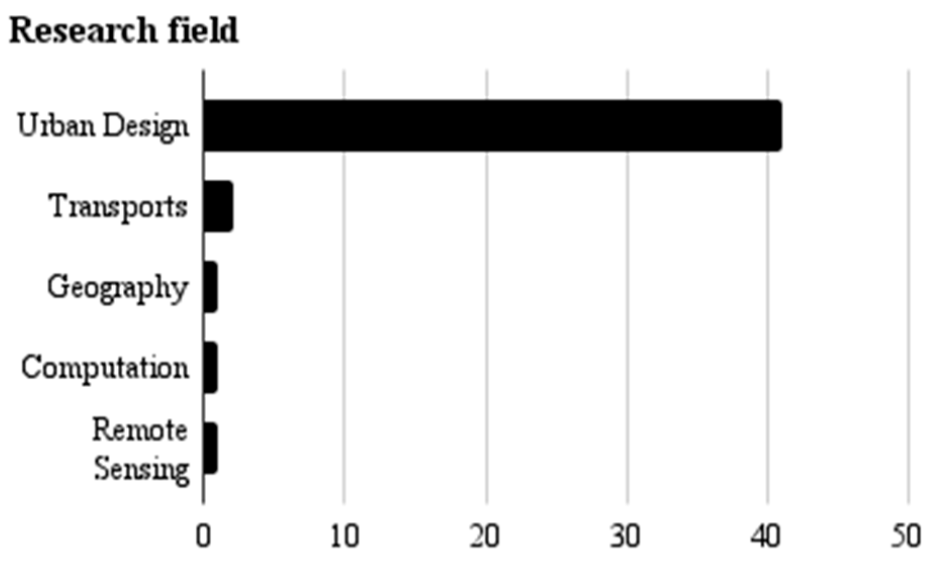
Concerning the research fields (Figure 3), most of the papers cataloged in the systematic review fell within the urban design topic. A few articles are related to geography, transport, or the development of computational or technological resources such as remote sensing. Even though these articles are directly related to other topics, the approach present in the research is encompassed in urban design. This finding highlights the connection and importance of urban design in shaping and implementing FMC.
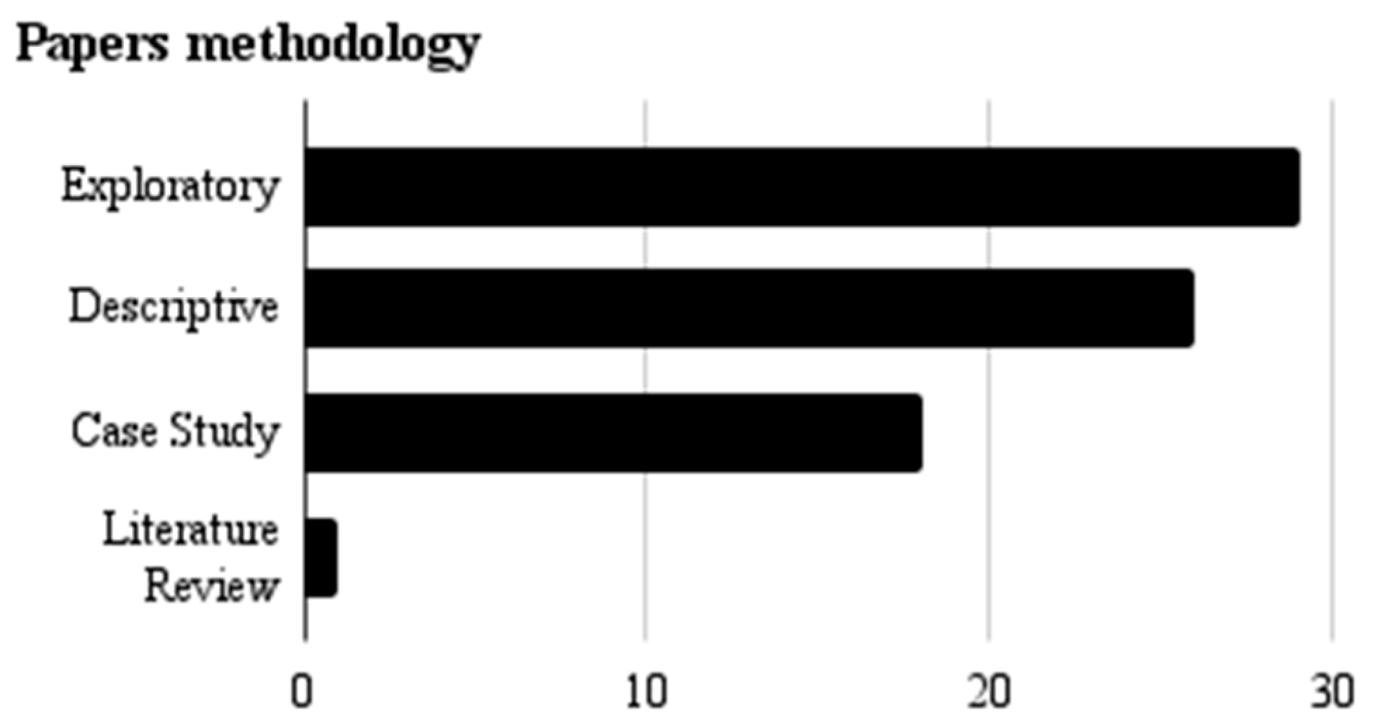
Exploratory research was present in 39.2% (n = 29) of the articles, which investigated new concepts or implemented original evaluation or design techniques. The descriptive methodology, in turn, was found in 35.1% (n = 26) of the studies, which provided detailed accounts of specific urban design features, policies, and practices related to FMC. Case studies accounted for 24.3% (n = 18) of the articles presenting context-specific approaches and connecting them to FMC. Lastly, literature reviews comprised 1.4% (n = 1) of the articles, synthesizing the existing knowledge on FMC. Figure 4 illustrates the number of papers that employ the addressed methodologies.
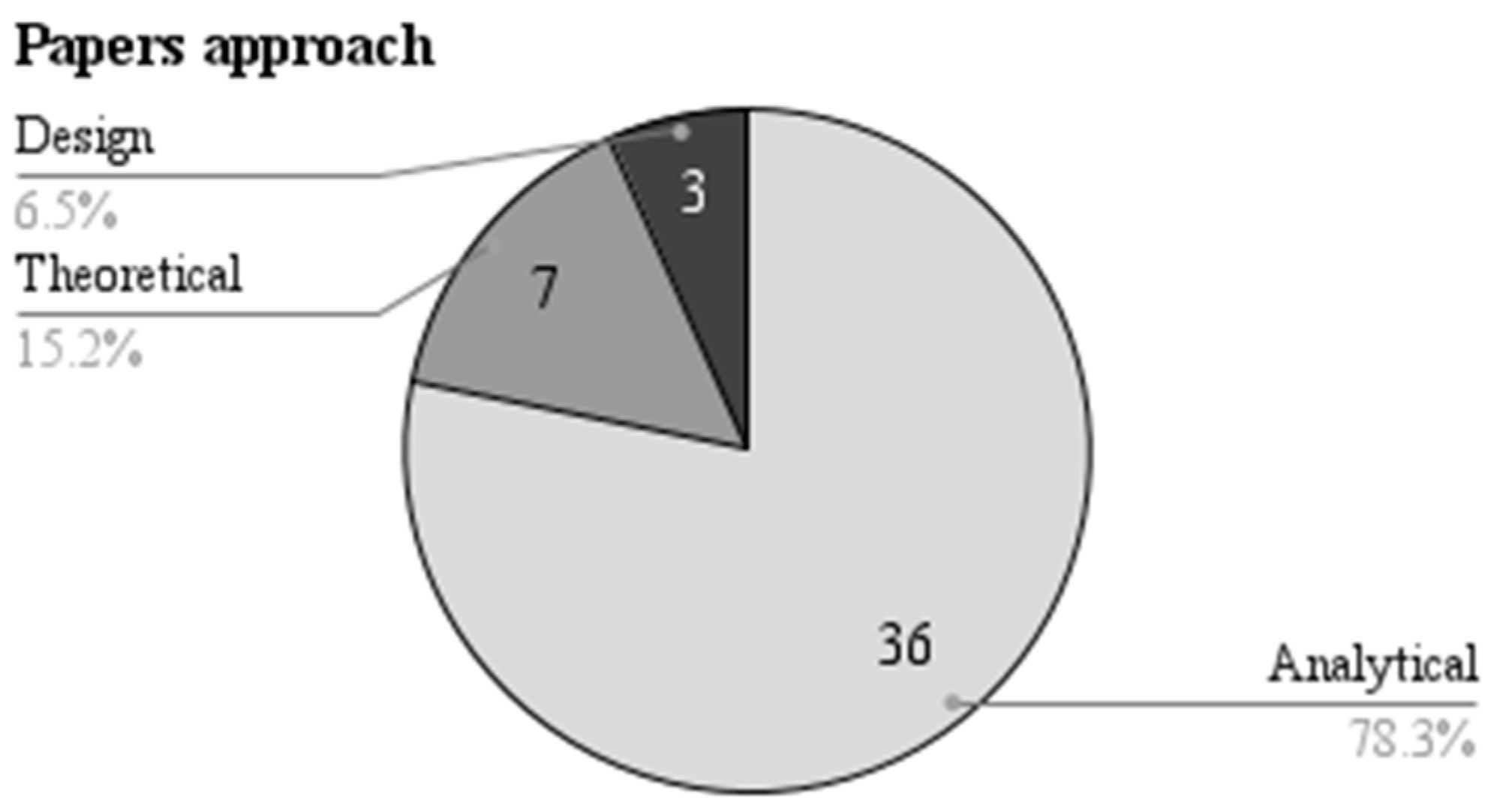
The reviewed papers embraced many approaches to structure their research on the FMC topic. Papers assessing FMC principles fell within the analytical approach and comprised 78.3% (n = 36) of the studies. The theoretical papers represent 15.2% (n = 7) of the articles. Lastly, design studies accounted for 6.5% (n = 3) of the articles. The results obtained are shown in Figure 5.
The reviewed articles focused on different sample scales when approaching FMC (Figure 6). Most of the articles, 54.3% (n = 25), investigated the concept at the neighborhood level, examining how FMC aspects affect local communities. City-level analyses were present in 28.3% (n = 13) of the papers, evaluating the impact of implementing 15-minute city strategies on the broader urban context. Block (4.3%/n = 2) and street (2.2%/n = 1) were the less commonly addressed scales. Lastly, 10.9% (n = 5) of the articles did not match a specific sample scale, mainly because they emphasize a broader theoretical scope, not related only to a single scale.
Regarding the type of samples used in the reviewed articles, the majority (73.9%/n = 34) focused on the urban fabric, examining the physical and spatial characteristics of 15-minute cities. Some articles (10.9%/n = 5) utilized data-driven approaches, analyzing various sources of information to assess the impact of the 15-minute city concept on urban environments. In the context of this article, the data mentioned is information such as the total number of people residing in a neighborhood, traffic data, mobile connection usage data, pedestrian movement, or the total number of amenities. Pictures are the less common sample type, representing 2.1% (n = 1) of the articles. Lastly, 13% (n = 6) of the articles did not specify the sample type adopted in their studies. Figure 7 illustrates the difference between the recurrence of the different samples adopted.
The reviewed articles were conducted in various countries, with country-specific contexts directly influencing the research (Figure 8). For instance, 12.8% (n = 6) of the articles focused on Italy, 8.5% (n = 4) on China, and 4.3% (n = 2) on the UK, Poland, and the USA. Other countries represented in the studies include the UAE, France, Morocco, Spain, Colombia, Poland, Germany, Mexico, Portugal, Korea, and Greece.
44.7% (n = 21) of the articles did not specify a particular country, suggesting that these studies adopted a broader and more generalist approach. While these research efforts may still be applied to specific regions, their overall focus is on a more comprehensive understanding and implications of 15-minute cities rather than being restricted to a single national context.
Concerning computational support (Figure 9), many reviewed articles adopt computer-aided applications. GIS-based (Geographic Information System) tools were utilized in 44% (n = 22) of the papers. Other tools included DepthMapX, OpenStreetMap (OSM), ESRI ArcMap 10.7, Rhinoceros + Grasshopper, UrMoAC, StreetGAN, SketchUp, EnergyPlus, ISO4App, and Urban Network Analysis (UNA).
However, 28% (n = 14) of the articles did not apply computer tools in their research, indicating that these studies employed alternative methods or focused on theoretical and conceptual aspects related to FMC.
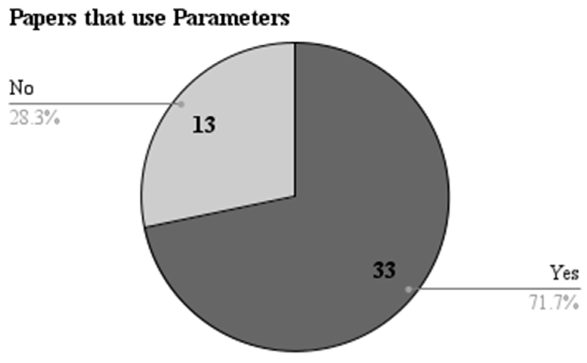
It is evident that most studies (71.7%/n = 33) employed parameters. This research applies metrics and objective/numeric criteria to assess and analyze FMC aspects. On the other hand, 28.3% (n = 13) of the articles did not incorporate parameters in their analyses, focusing instead on qualitative or theoretical aspects of the topic. This difference is illustrated in Figure 10.
Concerning the use of generative design, only (2.2%/n = 1) of reviewed papers adopt generative design techniques to approach FMC, with the remainder of the articles (97.8%/n = 45) not applying that technique (Figure 11).
5. Discussion
By proposing a review that analyzes the trends and patterns identified in the literature, we intend to contribute to a comprehensive understanding of the research scenario related to the FMC theme, promoting a greater exploration of tools that meet this rising urban planning paradigm.
Regarding the publication dates of the papers, all studies found through searches using the term “15-minute cities” were published after 2021. The surge in interest and focus on the FMC concept in recent years (with publication numbers increasing yearly) can be attributed to the popularization of the term first coined by Carlos Moreno in 2016 [33]. As the core concepts of FMC are not necessarily new, the articles found through searches using secondary keywords extend to the limit of the determined range for this literature review (2017). This range also highlights this subject’s growing interest in and relevance in recent years and its connections to pre-existing ideas and concepts in urban planning and design.
As expected, urban design was the predominant field of knowledge in the analyzed literature. It is noteworthy to mention the presence of articles related to the field of transportation [34,35], with research focusing on evaluating datasets to map accessibility to various modes of transportation. We also observed the presence of articles in the fields of geography [36], remote sensing [37], and computation [38]. These studies explore and develop techniques and tools to assist decision-makers in an urban context, highlighting the interdisciplinary nature of the FMC topic.
Regarding the methods used in the studies, based on Creswell’s categories [27], there was a predominance of exploratory and descriptive articles and a significant presence of case studies. Most articles employed more than one method in their structure to strengthen their approach. Given that the topic is relatively new and has been gaining relevance in the past three years, it is unsurprising to find exploratory research that intersects the FMC concept with various techniques or tools. Descriptive articles aimed to consolidate knowledge on FMC and comprehensively understand their scope. While some theoretical articles adopted a descriptive approach, revisiting concepts, we also found a literature review [39] that contributed to the ongoing discussion and the development of the FMC concept.
Most papers adopted an analytical approach, using aspects of FMC as a parameter for comparative evaluation. Although some articles focus on urban design, it can be argued that they provide mainly an analytical approach that can be considered in an evidence-based design context. Works addressing a design approach [24,40,41] employ generative tools to reconfigure the urban fabric, utilize technological resources to generate street networks or manipulate data to propose new configurations. There is a clear demonstration of the potential for integrating different methodological perspectives to advance the understanding and application of FMC in urban planning and design studies.
The most commonly adopted scale in the studies was the neighborhood. This scale allows for solid and informative explorations while dealing with the comprehensiveness of the sample vs. computational cost trade-off. On the other hand, approaches at the city scale [36,42,43,44,45,46,47,48,49,50,51,52,53] generally focus on evaluating street networks, overall accessibility to spaces, or the connectivity of the urban fabric. We also found one study that operates at the street scale [38], addressing the location of amenities and spatial quality with an emphasis on walkability. Additionally, works at the block scale [54,55] seek to establish discussions about providing services, public spaces, travel time, and how these factors impact daily life or even new pandemic scenarios.
The primary sample used in most studies is the urban fabric, mainly because it contains the majority of crucial elements of the urban space (streets, blocks, plots, empty spaces). A group of articles [34,35,36,44] also adopted data as their primary sample. These studies utilize consolidated data to establish relationships, equations, and formulas for analysis or proposals in the context of FMC. Few articles [38,41], in turn, adopted images as their sample, using generative adversarial networks to propose studies. Although a portion of the studies did not declare a specific sample [5,39,54,56,57,58], it is possible to understand that these works have a theoretical approach, thus justifying the absence of a direct relationship with a single sample.
Our findings indicate that urban multi-centrality is the primordial condition of the built environment related to the FMC. Given the theoretical basis of the FMC, it is possible to see a convergence towards the idea of high built and population density, a wide range of amenities and residences with a well-balanced distribution, adequate urban and transport infrastructure, and strengthening of social relations associated with city/public spaces.
Regarding the geographical distribution of the studies, it is evident that Europe has more related studies [42,45,47,49,59,60,61,62,63,64,65], possibly influenced by the strong association of the FMC concept with Paris. China, reinforcing its position as a country of recent scientific growth, also has some related studies [40,46,51,66,67]. The USA completes the list of the most recurring regions [24,53,68] with articles that apply the FMC concept to the reality of cities predominantly reliant on individual car transportation. The other countries related to the studies [36,52,69,70,71] demonstrate an explicit diffusion of the topic and acceptance by the academic community that FMC represents a potential solution for sustainable development. This global interest also underscores the relevance and applicability of FMC across many urban contexts and cultural backgrounds.
Regarding the use of resources to support the research, a considerable portion of the studies explicitly declared the parameters they applied in the context of their work [24,34,35,40,41,42,43,44,45,46,48,49,50,51,52,53,55,59,60,62,64,65,66,67,68,70,71,72,73,74,75,76,77]. This finding is relevant as it directly associates the field of urban design, oriented towards FMC, with performance metrics. Objective approaches reduce the interpretive margin and facilitate the association of optimistic scenarios for FMC, which can be a significant opportunity for introducing new studies. This trend towards metrics-based research underscores the potential for more informed decision-making and the development of sustainable urban planning and design policies that incorporate FMC.
Delving deeper into our assessment of the use of computational resources, we found that only one study [24] adopts a generative approach. A possible justification is given by the fact that most of the works consulted adopted GIS-based approaches, and this technique does not easily connect to generative design resources. Another point related to the low adherence to generative design is the predominant analytical nature of the studied papers. Analyzing the literature, it is clear that parametric and generative urban design has experienced prominent growth in recent years. Only one article employing this technique opens up discussions highlighting the opportunity for further exploration, fostering innovative design solutions, and more robust analyses of urban environments in pursuit of sustainable development goals aligned with FMC.
Computational approaches such as parametric urban design, generative urban design, and performance-based urban design provide a powerful toolkit for creating more effective and efficient 15-minute cities. All these techniques combined can significantly improve the design and implementation of FMC. The parametric urban design logic allows for a flexible design process, offering an adaptive framework for urban planning. By setting specific parameters, such as density, building heights, amenities recurrence, or green space ratios, designers can generate diverse urban scenarios and assess how they conform to FMC. In turn, generative design extends this potential by using algorithms to create design solutions based on predefined goals, such as maximizing walkability, pedestrian accessibility, or minimizing carbon emissions. These allow designers to rapidly test thousands of possibilities, greatly aiding in the search for the most optimal urban configuration.
The performance-based urban design incorporates real-world data into the decision-making process. It could be used to monitor and analyze the impact of implemented changes in real-time, ensuring the urban fabric remains adaptive and responsive to the needs of residents. Integrating the mentioned techniques with multi-objective optimization can resolve conflicts and trade-offs between different objectives, ensuring a balanced approach. For instance, they can be used to balance the need for increased density with the requirement for green space, enabling the creation of livable, sustainable, and efficient 15-minute cities.
Introducing computational approaches to 15-minute city design presents significant challenges and potential bottlenecks. On the other hand, exploring these challenges as opportunities for inserting new research is also possible since the theme is rising, as highlighted by this review. Among the challenges, we can mention:
- Data availability and quality: These computational models require large amounts of high-quality data to be accurate and useful. Obtaining this data can be complex, particularly in areas with limited or non-existent data collection infrastructure.
- Interdisciplinary integration: The complexity of urban environments requires expertise from multiple disciplines, including urban planning, data science, transportation, environment, and social sciences. Building collaborative, interdisciplinary teams can be challenging, but it is necessary to understand and address the complexities of urban environments fully.
- Computational cost: These computational techniques can be computationally intensive, particularly those involving multiple-objective optimizations or generative design, slowing down the design process, particularly for larger cities.
- Adaptability: Cities are dynamic and constantly changing, and computational models must adapt. Ensuring that models are flexible and adaptable is a significant challenge.
- Policy and Regulation: Implementation of these computational designs must navigate the complex landscape of urban planning regulations and policy, which can differ significantly between locations. The difference between regulations adds a layer of complexity to the implementation of 15-minute cities, which brings us to the next challenge: engagement;
- Stakeholder Engagement: Engaging a broad range of stakeholders, including residents, businesses, and policymakers, is critical for successfully implementing 15-minute cities. Achieving a general consensus can be a significant challenge.
Overcoming these challenges requires continued research, collaboration, and a commitment to equity, transparency, and community engagement in the planning process. With this in mind, this article intends to encourage further adoption of computational tools and techniques in designing 15-minute cities.
Author Contributions
Conceptualization, F.T.L. and F.C.; Methodology, F.C. and F.T.L.; Data curation, F.C.; writing—original draft preparation, F.C. and F.T.L.; Writing—review and editing, F.T.L. and F.C. All authors have read and agreed to the published version of the manuscript.
Funding
This research was funded by FAPEMIG (Fundação de Amparo à Pesquisa do Estado de Minas Gerais, Brazil) and the Coordination for the Improvement of Higher Education Personnel—Brazil (CAPES)—Financing Code 001.
Institutional Review Board Statement
Not applicable.
Informed Consent Statement
Not applicable.
Data Availability Statement
Data is available from the corresponding author upon written request and subject to review.
Acknowledgments
We thank the O’More College of Architecture and Design at Belmont University and the Federal University of Paraíba for their infrastructure and resources, providing an environment conducive to intellectual growth and pursuing knowledge, fostering the development of this article and the ideas presented.
Conflicts of Interest
The authors declare no conflict of interest.
Appendix A
Figure A1.
A Synthesis of the studied articles.

References
- Matlovičová, K.; Mocák, P.; Kolesárová, J. Environment of Estates and Crime Prevention through Urban Environment Formation and Modification. Geogr. Pannonica 2016, 20, 168–180. [Google Scholar] [CrossRef]
- United Nations. Fact Sheet Climate Change—Sustainable Transport Conference; United Nations: Beijing, China, 2021.
- 7 Million Premature Deaths Annually Linked to Air Pollution. Available online: https://www.who.int/news/item/25-03-2014-7-million-premature-deaths-annually-linked-to-air-pollution (accessed on 13 April 2023).
- Burd, C.; Burrows, M.; McKenzie, B. Travel Time to Work in the United States: 2019; American Community Survey Reports; United States Census Bureau: Washington, DC, USA, 2021.
- Moreno, C.; Allam, Z.; Chabaud, D.; Gall, C.; Pratlong, F. Introducing the “15-Minute City”: Sustainability, Resilience and Place Identity in Future Post-Pandemic Cities. Smart Cities 2021, 4, 93–111. [Google Scholar] [CrossRef]
- Carozzi, F. Urban Density and Covid-19; Social Science Research Network: Rochester, NY, USA, 2020. [Google Scholar]
- Lima, F.T.; Brown, N.C.; Duarte, J.P. Understanding the Impact of Walkability, Population Density, and Population Size on COVID-19 Spread: A Pilot Study of the Early Contagion in the United States. Entropy 2021, 23, 1512. [Google Scholar] [CrossRef] [PubMed]
- Jardim, B.; de Castro Neto, M. Walkability Indicators in the Aftermath of the COVID-19 Pandemic: A Systematic Review. Sustainability 2022, 14, 10933. [Google Scholar] [CrossRef]
- Ildefons, C. General Theory of Urbanization 1867; Vicente, G., Ed.; English Edition; Actar: Barcelona, Spain, 2018; ISBN 978-1-945150-90-6. [Google Scholar]
- Krier, R. Urban Space; Rizzoli: New York, NY, USA, 1993; ISBN 978-0-8478-0236-4. [Google Scholar]
- Jacobs, J. The Death and Life of Great American Cities; Reissue Edition; Vintage: New York, NY, USA, 1992; ISBN 978-0-679-74195-4. [Google Scholar]
- Pachura, P.; Nitkiewicz, T.; Matlovičová, K.; Matlovič, R. Identification of Intellectual Capital Performance Using Data Envelopment Analysis. In Knowledge Spillovers in Regional Innovation Systems: A Case Study of CEE Regions; Stejskal, J., Hajek, P., Hudec, O., Eds.; Advances in Spatial Science; Springer International Publishing: Cham, Switzerland, 2018; pp. 115–130. ISBN 978-3-319-67029-4. [Google Scholar]
- Steinø, N.; Veirum, N. A Parametric Approach to Urban Design. Digital Design: The Quest for New Paradigms. In Proceedings of the 23rd eCAADe Conference, Lisbon, Portugal, 21–24 September 2005; pp. 679–686. [Google Scholar]
- Duarte, J.P.; Beirão, J.N.; Montenegro, N.; Gil, J. City Induction: A Model for Formulating, Generating, and Evaluating Urban Designs. In Digital Urban Modeling and Simulation; Arisona, S.M., Aschwanden, G., Halatsch, J., Wonka, P., Eds.; Communications in Computer and Information Science; Springer: Berlin/Heidelberg, Germany, 2012; pp. 73–98. ISBN 978-3-642-29758-8. [Google Scholar]
- Beirão, J. CityMaker. Designing Grammars for Urban Design; TU Delft: Delft, The Netherlands, 2012. [Google Scholar]
- Montenegro, N. CityPlan; Faculdade de Arquitetura, Universidade de Lisboa: Lisbon, Spain, 2015. [Google Scholar]
- Lima, F. Urban Metrics: (Para)Metric System for Analysis and Optimization of Urban Configurations. Ph.D. Thesis, Federal University of Rio de Janeiro, Rio de Janeiro, Brazil, 2017. [Google Scholar]
- Sevtsuk, A.; Mekonnen, M. Urban Network Analysis. A New Toolbox for ArcGIS. Rev. Int. Géomat. 2012, 22, 287–305. [Google Scholar] [CrossRef]
- Sevtsuk, A. Urban Network Analysis. Tools for Modeling Pedestrian and Bicycle Trips in Cities; City Form Lab: Cambridge, MA, USA, 2018; ISBN 978-0-692-17277-3. [Google Scholar]
- Nourian, P.; Rezvani, S.; Sariyildiz, I.; Van der Hoeven, F. Configurbanist: Urban Configuration Analysis for Walking and Cycling via Easiest Paths. Towards Smarter Cities. In Proceedings of the 33rd Annual eCAADe Conference, Vienna, Austria, 16–18 September 2015; Volume 1. [Google Scholar]
- Lima, F.; Montenegro, N.; Paraizo, R.; Kós, J. Urbanmetrics: An Algorithmic-(Para)Metric Methodology for Analysis and Optimization of Urban Configurations. In Planning Support Science for Smarter Urban Futures; Geertman, S., Allan, A., Pettit, C., Stillwell, J., Eds.; Lecture Notes in Geoinformation and Cartography; Springer International Publishing: Cham, Switzerland, 2017; pp. 47–64. ISBN 978-3-319-57819-4. [Google Scholar]
- Lima, F.T.D.A.; Montenegro, N.; Paraizo, R.C.; Kós, J.R. Citymetrics: Sistema (Para) Métrico Para Análise e Otimização de Configurações Urbanas. Oculum Ens. 2019, 16, 409–427. [Google Scholar] [CrossRef]
- Dogan, T.; Yang, Y.; Samaranayake, S.; Saraf, N. Urbano: A Tool to Promote Active Mobility Modeling and Amenity Analysis in Urban Design. Technol. Des. 2020, 4, 92–105. [Google Scholar] [CrossRef]
- Lima, F.T.; Brown, N.C.; Duarte, J.P. A Grammar-Based Optimization Approach for Designing Urban Fabrics and Locating Amenities for 15-Minute Cities. Buildings 2022, 12, 1157. [Google Scholar] [CrossRef]
- Lima, F.; Brown, N.; Duarte, J.P. A Grammar-Based Optimization Approach for Walkable Urban Fabrics Considering Pedestrian Accessibility and Infrastructure Cost. Environ. Plan. B Urban Anal. City Sci. 2021, in press. [Google Scholar] [CrossRef]
- Page, M.J.; McKenzie, J.E.; Bossuyt, P.M.; Boutron, I.; Hoffmann, T.C.; Mulrow, C.D.; Shamseer, L.; Tetzlaff, J.M.; Akl, E.A.; Brennan, S.E.; et al. The PRISMA 2020 Statement: An Updated Guideline for Reporting Systematic Reviews. BMJ 2021, 372, n71. [Google Scholar] [CrossRef]
- Creswell, J.W. Research Design: Qualitative, Quantitative, and Mixed Methods Approaches; Sage Publications: Thousand Oaks, CA, USA, 2013; ISBN 978-1-4522-2610-1. [Google Scholar]
- Groat, L.N.; Wang, D. Architectural Research Methods, 2nd ed.; John Wiley & Sons: Hoboken, NJ, USA, 2013; ISBN 978-0-470-90855-6. [Google Scholar]
- Teeling, C. Algorithmic Design: Generating Urban Form. Urban Des. Stud. 1996, 2, 89–100. [Google Scholar]
- Gil, J.; Duarte, J.P. Towards an Urban Design Evaluation Framework. Architecture in Computro. In Proceedings of the 26th eCAADe Conference, Antwerpen, Belgium, 17–20 September 2008; pp. 257–264, ISBN 978-0-9541183-7-2. [Google Scholar]
- Navarro-Mateu, D.; Makki, M.; Cocho-Bermejo, A. Urban-Tissue Optimization through Evolutionary Computation. Mathematics 2018, 6, 189. [Google Scholar] [CrossRef] [Green Version]
- Makki, M.; Showkatbakhsh, M.; Tabony, A.; Weinstock, M. Evolutionary Algorithms for Generating Urban Morphology: Variations and Multiple Objectives. Int. J. Archit. Comput. 2019, 17, 5–35. [Google Scholar] [CrossRef]
- The 15-Minute City—OBEL AWARD. Available online: https://obelaward.org/winner/cities/ (accessed on 1 November 2022).
- Willberg, E.; Fink, C.; Toivonen, T. The 15-Minute City for All?—Measuring Individual and Temporal Variations in Walking Accessibility. J. Transp. Geogr. 2023, 106, 103521. [Google Scholar] [CrossRef]
- Zagorskas, J.; Turskis, Z. Location Preferences of New Pedestrian Bridges Based on Multi-Criteria Decision-Making and GIS-Based Estimation. Balt. J. Road Bridge Eng. 2020, 15, 158–181. [Google Scholar] [CrossRef]
- Guzman, L.A.; Arellana, J.; Oviedo, D.; Moncada Aristizábal, C.A. COVID-19, Activity and Mobility Patterns in Bogotá. Are We Ready for a ‘15-Minute City’? Travel Behav. Soc. 2021, 24, 245–256. [Google Scholar] [CrossRef]
- Fernández-Arango, D.; Varela-García, F.-A.; González-Aguilera, D.; Lagüela-López, S. Automatic Generation of Urban Road 3D Models for Pedestrian Studies from LiDAR Data. Remote Sens. 2022, 14, 1102. [Google Scholar] [CrossRef]
- Wijnands, J.S.; Nice, K.A.; Thompson, J.; Zhao, H.; Stevenson, M. Streetscape Augmentation Using Generative Adversarial Networks: Insights Related to Health and Wellbeing. Sustain. Cities Soc. 2019, 49, 101602. [Google Scholar] [CrossRef] [Green Version]
- Khavarian-Garmsir, A.R.; Sharifi, A.; Sadeghi, A. The 15-Minute City: Urban Planning and Design Efforts toward Creating Sustainable Neighborhoods. Cities 2023, 132, 104101. [Google Scholar] [CrossRef]
- Li, Y.; Chai, Y.; Chen, Z.; Li, C. From Lockdown to Precise Prevention: Adjusting Epidemic-Related Spatial Regulations from the Perspectives of the 15-Minute City and Spatiotemporal Planning. Sustain. Cities Soc. 2023, 92, 104490. [Google Scholar] [CrossRef]
- Fang, Z.; Jin, Y.; Yang, T. Incorporating Planning Intelligence into Deep Learning: A Planning Support Tool for Street Network Design. J. Urban Technol. 2022, 29, 99–114. [Google Scholar] [CrossRef]
- Abdelfattah, L.; Deponte, D.; Fossa, G. The 15-Minute City as a Hybrid Model for Milan. TeMA–J. Land Use Mobil. Environ. 2022, 71–86. [Google Scholar] [CrossRef]
- Logan, T.M.; Hobbs, M.H.; Conrow, L.C.; Reid, N.L.; Young, R.A.; Anderson, M.J. The X-Minute City: Measuring the 10, 15, 20-Minute City and an Evaluation of Its Use for Sustainable Urban Design. Cities 2022, 131, 103924. [Google Scholar] [CrossRef]
- Bartzokas-Tsiompras, A.; Bakogiannis, E. Quantifying and Visualizing the 15-Minute Walkable City Concept across Europe: A Multicriteria Approach. J. Maps 2022, 1–9. [Google Scholar] [CrossRef]
- Ferrer-Ortiz, C.; Marquet, O.; Mojica, L.; Vich, G. Barcelona under the 15-Minute City Lens: Mapping the Accessibility and Proximity Potential Based on Pedestrian Travel Times. Smart Cities 2022, 5, 146–161. [Google Scholar] [CrossRef]
- Song, G.; He, X.; Kong, Y.; Li, K.; Song, H.; Zhai, S.; Luo, J. Improving the Spatial Accessibility of Community-Level Healthcare Service toward the ‘15-Minute City’ Goal in China. ISPRS Int. J. Geo-Inf. 2022, 11, 436. [Google Scholar] [CrossRef]
- Noworól, A.; Kopyciński, P.; Hałat, P.; Salamon, J.; Hołuj, A. The 15-Minute City—The Geographical Proximity of Services in Krakow. Sustainability 2022, 14, 7103. [Google Scholar] [CrossRef]
- Balletto, G.; Ladu, M.; Milesi, A.; Borruso, G. A Methodological Approach on Disused Public Properties in the 15-Minute City Perspective. Sustainability 2021, 13, 593. [Google Scholar] [CrossRef]
- Monteiro, J.; Para, M.; Sousa, N.; Natividade-Jesus, E.; Ostorero, C.; Coutinho-Rodrigues, J. Filling in the Spaces: Compactifying Cities towards Accessibility and Active Transport. ISPRS Int. J. Geo-Inf. 2023, 12, 120. [Google Scholar] [CrossRef]
- Boeing, G. OSMnx: New Methods for Acquiring, Constructing, Analyzing, and Visualizing Complex Street Networks. Comput. Environ. Urban Syst. 2017, 65, 126–139. [Google Scholar] [CrossRef] [Green Version]
- Tang, B.-S.; Wong, K.K.; Tang, K.S.; Wai Wong, S. Walking Accessibility to Neighbourhood Open Space in a Multi-Level Urban Environment of Hong Kong. Environ. Plan. B Urban Anal. City Sci. 2021, 48, 1340–1356. [Google Scholar] [CrossRef]
- Kang, C.-D. The S + 5Ds: Spatial Access to Pedestrian Environments and Walking in Seoul, Korea. Cities 2018, 77, 130–141. [Google Scholar] [CrossRef]
- Sevtsuk, A.; Basu, R.; Li, X.; Kalvo, R. A Big Data Approach to Understanding Pedestrian Route Choice Preferences: Evidence from San Francisco. Travel Behav. Soc. 2021, 25, 41–51. [Google Scholar] [CrossRef]
- Bocca, A. Public Space and 15-Minute City. A Conceptual Exploration for the Functional Reconfiguration of Proximity City. TeMA–J. Land Use Mobil. Environ. 2021, 14, 395–410. [Google Scholar] [CrossRef]
- Palominos, N.; Smith, D.A. Examining the Geometry of Streets through Accessibility: New Insights from Streetspace Allocation Analysis. Environ. Plan. B Urban Anal. City Sci. 2022, 23998083221139849. [Google Scholar] [CrossRef]
- Mocak, P.; Matlovicova, K.; Matlovic, R.; Penzes, J.; Pachura, P.; Mishra, P.K.; Kostilnikova, K.; Demkova, M. 15-Minute City Concept as a Sustainable Urban Development Alternative: A Brief Outline of Conceptual Frameworks and Slovak Cities as a Case. Folia Geogr. 2022, 64, 69–89. [Google Scholar]
- Allam, Z.; Bibri, S.E.; Chabaud, D.; Moreno, C. The Theoretical, Practical, and Technological Foundations of the 15-Minute City Model: Proximity and Its Environmental, Social and Economic Benefits for Sustainability. Energies 2022, 15, 6042. [Google Scholar] [CrossRef]
- Pozoukidou, G.; Angelidou, M. Urban Planning in the 15-Minute City: Revisited under Sustainable and Smart City Developments until 2030. Smart Cities 2022, 5, 1356–1375. [Google Scholar] [CrossRef]
- Barbieri, L.; D’Autilia, R.; Marrone, P.; Montella, I. Graph Representation of the 15-Minute City: A Comparison between Rome, London, and Paris. Sustainability 2023, 15, 3772. [Google Scholar] [CrossRef]
- Gaglione, F.; Gargiulo, C.; Zucaro, F.; Cottrill, C. 15-Minute Neighbourhood Accessibility: A Comparison between Naples and London. Eur. Transp.-Trasp. Eur. 2021, 85, 1–16. [Google Scholar] [CrossRef]
- Hölzel, M.; Kolsch, K.-H.; de Vries, W.T. Location of Coworking Spaces (CWSs) Regarding Vicinity, Land Use and Points of Interest (POIs). Land 2022, 11, 354. [Google Scholar] [CrossRef]
- Jaroszewicz, J.; Denis, M.; Fijałkowska, A.; Graszka, O.; Pluto-Kossakowska, J.; Krzysztofowicz, S. Spatially Explicit Mixed-Use Indicators to Measure Life Quality across the City—A Conceptual Framework and Case Study: Piaseczno—A Medium Sized City in the Peri-Urban Zone of Warsaw, Poland. Cities 2023, 137, 104296. [Google Scholar] [CrossRef]
- Marchigiani, E.; Bonfantini, B. Urban Transition and the Return of Neighbourhood Planning. Questioning the Proximity Syndrome and the 15-Minute City. Sustainability 2022, 14, 5468. [Google Scholar] [CrossRef]
- Gaglione, F.; Gargiulo, C.; Zucaro, F. Where Can the Elderly Walk? A Spatial Multi-Criteria Method to Increase Urban Pedestrian Accessibility. Cities 2022, 127, 103724. [Google Scholar] [CrossRef]
- Tsigdinos, S.; Latinopoulou, M.; Paraskevopoulos, Y. Network Configuration as Tool for Improving Pedestrian Accessibility. Implementing a Street Design Methodology in an Athenian Neighbourhood. In Proceedings of the 12th Space Syntax Symposium, Beijing, China, 8–13 July 2019. [Google Scholar]
- Qian, C.; Zhu, D.; Zhou, Y.; Chen, J. Measurements of Pedestrian Friendliness of Residential Area: A Case Study in Hexi District of Nanjing. Sustainability 2018, 10, 1993. [Google Scholar] [CrossRef] [Green Version]
- Zhao, J.; Su, W.; Luo, J.; Zuo, J. Evaluation and Optimization of Walkability of Children’s School Travel Road for Accessibility and Safety Improvement. Int. J. Environ. Res. Public. Health 2021, 19, 71. [Google Scholar] [CrossRef]
- Chen, Q.; Crooks, A.T. Delineating a “15-Minute City”: An Agent-Based Modeling Approach to Estimate the Size of Local Communities. In Proceedings of the 4th ACM SIGSPATIAL International Workshop on GeoSpatial Simulation, Association for Computing Machinery, New York, NY, USA, 18 November 2021; pp. 29–37. [Google Scholar]
- Harroucha, R.; Chaouni, A.-A. Mosques Pedestrian Accessibility Analysis under the 15 Min Cities Concept. GeoJournal 2023. [Google Scholar] [CrossRef]
- Gaxiola-Beltrán, A.L.; Narezo-Balzaretti, J.; Ramírez-Moreno, M.A.; Pérez-Henríquez, B.L.; Ramírez-Mendoza, R.A.; Krajzewicz, D.; Lozoya-Santos, J. de-Jesús Assessing Urban Accessibility in Monterrey, Mexico: A Transferable Approach to Evaluate Access to Main Destinations at the Metropolitan and Local Levels. Appl. Sci. 2021, 11, 7519. [Google Scholar] [CrossRef]
- Kashef, M. The Building Blocks of Walkability: Pedestrian Activity in Abu Dhabi City Center. Front. Archit. Res. 2022, 11, 203–223. [Google Scholar] [CrossRef]
- Balletto, G.; Pezzagno, M.; Richiedei, A. 15-Minute City in Urban Regeneration Perspective: Two Methodological Approaches Compared to Support Decisions. In Proceedings of the Computational Science and Its Applications—ICCSA 2021; Gervasi, O., Murgante, B., Misra, S., Garau, C., Blečić, I., Taniar, D., Apduhan, B.O., Rocha, A.M.A.C., Tarantino, E., Torre, C.M., Eds.; Springer International Publishing: Cham, Switzerland, 2021; pp. 535–548. [Google Scholar]
- Carpio-Pinedo, J.; Benito-Moreno, M.; Lamíquiz-Daudén, P.J. Beyond Land Use Mix, Walkable Trips. An Approach Based on Parcel-Level Land Use Data and Network Analysis. J. Maps 2021, 17, 23–30. [Google Scholar] [CrossRef]
- Pafka, E.; Dovey, K.; Aschwanden, G.D. Limits of Space Syntax for Urban Design: Axiality, Scale and Sinuosity. Environ. Plan. B Urban Anal. City Sci. 2020, 47, 508–522. [Google Scholar] [CrossRef]
- Hachem-Vermette, C.; Singh, K. Mixed-Use Neighborhoods Layout Patterns: Impact on Solar Access and Resilience. Sustain. Cities Soc. 2019, 51, 101771. [Google Scholar] [CrossRef]
- Rossetti, S.; Tiboni, M.; Vetturi, D.; Zazzi, M.; Caselli, B. Measuring Pedestrian Accessibility to Public Transport in Urban Areas: A GIS-Based Discretisation Approach. Eur. Transp. Eur. 2020, 76, 1–12. [Google Scholar]
- Caselli, B.; Carra, M.; Rossetti, S.; Zazzi, M. From Urban Planning Techniques to 15-Minute Neighbourhoods. A Theoretical Framework and GIS-Based Analysis of Pedestrian Accessibility to Public Services. Eur. Transp. Eur. 2021, 1–15. [Google Scholar] [CrossRef]
Figure 1.
Methodology workflow.

Figure 2.
Chart illustrating in which year the FMC theme and its correlates were most discussed.

Figure 3.
Field of knowledge of the papers.

Figure 4.
Primary methodologies used in the articles.

Figure 5.
Types of approaches used in the papers.

Figure 6.
Most adopted sample scales.

Figure 7.
Type of sample used in the articles.

Figure 8.
Countries correlated to the studies. The chart excludes works that do not associate with a specific country.
Figure 8.
Countries correlated to the studies. The chart excludes works that do not associate with a specific country.

Figure 9.
Software and computational resources employed in the papers.

Figure 10.
Relationship between articles that adopt and do not adopt parameters in their approach.

Figure 11.
Relationship between clays that use and do not use Generative Design resources.


Table 1.
Synthesized quantitative data from the systematic review.
| Database | Keywords | Hits | Exclusions | Selected |
|---|---|---|---|---|
| Web of Science | 15 minutes cities | 37 | 14 | 23 |
| Street Network Design | 19 | 13 | 6 | |
| Street Network Layout | 3 | 2 | 1 | |
| Pedestrian accessibility | 94 | 85 | 9 | |
| Scopus | “15 minutes cities” | 53 | 48 | 5 |
| “Street Network Design” | 2 | 2 | 0 | |
| “Street Network Layout” | 2 | 2 | 0 | |
| “Pedestrian accessibility” | 34 | 32 | 2 | |
| - | Total number of papers | 244 | 198 | 46 |
Disclaimer/Publisher’s Note: The statements, opinions and data contained in all publications are solely those of the individual author(s) and contributor(s) and not of MDPI and/or the editor(s). MDPI and/or the editor(s) disclaim responsibility for any injury to people or property resulting from any ideas, methods, instructions or products referred to in the content. |
© 2023 by the authors. Licensee MDPI, Basel, Switzerland. This article is an open access article distributed under the terms and conditions of the Creative Commons Attribution (CC BY) license (https://creativecommons.org/licenses/by/4.0/).
Share and Cite
MDPI and ACS Style
Lima, F.T.; Costa, F. The Quest for Proximity: A Systematic Review of Computational Approaches towards 15-Minute Cities. Architecture 2023, 3, 393-409. https://0-doi-org.brum.beds.ac.uk/10.3390/architecture3030021
AMA Style
Lima FT, Costa F. The Quest for Proximity: A Systematic Review of Computational Approaches towards 15-Minute Cities. Architecture. 2023; 3(3):393-409. https://0-doi-org.brum.beds.ac.uk/10.3390/architecture3030021
Chicago/Turabian StyleLima, Fernando T., and Frederico Costa. 2023. "The Quest for Proximity: A Systematic Review of Computational Approaches towards 15-Minute Cities" Architecture 3, no. 3: 393-409. https://0-doi-org.brum.beds.ac.uk/10.3390/architecture3030021