Article

Quantifying Abundance and Mapping Distribution of Loggerhead Turtles in the Mediterranean Sea Using Aerial Surveys: Implications for Conservation

by
Nino Pierantonio
1,*,
Simone Panigada
1 and
Giancarlo Lauriano
2
1
Tethys Research Institute, Viale G. B. Gadio 2, 20121 Milano, Italy
2
The Italian Institute for Environmental Protection and Research, ISPRA, Via V. Brancati 48, 00144 Rome, Italy
*
Author to whom correspondence should be addressed.
Submission received: 5 October 2023 / Revised: 1 November 2023 / Accepted: 2 November 2023 / Published: 21 November 2023
(This article belongs to the Special Issue Biodiversity in Italy: Past and Future Perspectives)

Abstract

:
In the Mediterranean, incidental captures in fishing gear contribute to the high mortality of loggerhead turtles (Caretta caretta). Understanding the effects of bycatch is complex and requires robust knowledge of baseline population parameters such as abundance and density, as well as an understanding of animals’ distribution in relation to commercial fishing efforts. Based on data collected during multi-species line transect aerial surveys conducted between 2009 and 2017, we present density and abundance estimates, corrected for availability bias, for a large sector of the central Mediterranean, discuss temporal and spatial patterns and provide Potential Biological Removal (PBR) values for the monitored areas. Sightings data were also used to evaluate the spatial and temporal usage areas. Strong latitudinal and longitudinal gradients in density, abundance and area usage emerged from the analysis, with turtles occurring in higher numbers in the deeper pelagic waters of the Tunisian Plateau, the Ionian Sea and the Gulf of Taranto, irrespective of the season. PBR values derived from this study are likely unsustainable. This paper investigates the implications of commercial fisheries for Mediterranean loggerhead turtles across an area rarely included in sea turtle monitoring and has the potential to be relevant towards informed management and conservation of this species and highlights the necessity of international collaborative efforts in the region.

1. Introduction

Monitoring wildlife population parameters such as abundance and density over time and across space is pivotal to identify underlying drivers of changes and constitutes the backbone of evidence-based conservation (e.g., [1]). In this regard, assessing abundance and density for a given species is not only essential for managing populations and prioritizing conservation measures [2,3], but also a legal obligation under several regional and international conventions and regulations, such as the EU Habitas (92/43/EEC) and Marine Strategy Framework Directives (MSFD; 2008/56/CE).
Globally, sea turtle populations have declined [4], and although pressures vary across regions, bycatch in commercial fishery operations is recognized as one of the main drivers of the observed decline [5,6].
The Mediterranean Sea hosts two populations of sea turtles: loggerhead (Caretta caretta) and green (Chelonia mydas) turtles, and it is also visited by species of Atlantic origin [7]. The loggerhead turtle is considered the most abundant species [7] and is included in Annex II and IV of the Habitats Directive as a species of community interest, which requires both special areas of conservation and strict protection. Its conservation status was down-listed in 2015 from Endangered to Least concern, according to the International Union for the Conservation of Nature (IUCN) Red List criteria [8]. Despite the down-listing, incidental captures in fishing gears still contribute to high mortality [9,10]. In fact, the Mediterranean Sea shows the highest unsustainable bycatch rates of marine turtles worldwide [7,10,11]. At the Basin level, Lucchetti and Sala [9] and Casale [12] report 132,000 sea turtles unintentionally caught during commercial fishing operations annually, with over 44,000 deaths per year. In Italian waters, Lucchetti et al., [13] estimated more than 52,000 bycatch events and up to 10,000 deaths in 2014 alone. More recently, in the north Adriatic Sea, the annual turtle bycatch due to bottom trawling has been estimated as 8600 individuals [14]. In the region, despite growing efforts to monitor the conservation status of sea turtles, the difficulties in assessing the volume and the impacts of bycatch [15,16] prevent the effective evaluation of the extent and the real effects of this threat [17].
Assessing absolute, unbiased abundance and trends over time is a priority for sea turtle conservation [7]; however, evaluating these parameters and the effects of bycatch is challenging due to the inherent complexity of sea turtle life history [18]. Traditionally, the monitoring of nesting beaches has been used to assess population parameters [19,20,21,22], but the drawbacks of this approach [18,23,24,25] can result in drastic overestimates, making at-sea sampling crucial to complement traditional approaches.
Dedicated aerial surveys are considered one of the most robust tools to gather information on sea turtle density, abundance and distribution [7,10,26], but while aerial line transect distance sampling surveys are regularly used worldwide to assess these population parameters for sea turtles [27,28,29,30,31,32], in the Mediterranean Sea, this approach has been used primarily to monitor Cetaceans [33,34,35,36,37,38]. Only recently aerial surveys have been used to assess loggerhead turtles’ abundance at a regional level [39], with relatively little effort allocated in the past [35,40,41].
Wide scale assessments of loggerhead turtle abundance are a pivotal first step to evaluate the sustainability of bycatch and eventually identify areas where the susceptibility of these species to commercial fisheries is high. In this context, this study presents original abundance/density estimates of loggerhead sea turtles for the central Mediterranean Sea and presents maps of inter-annual and seasonal use of space for those sectors monitored multiple times over the years and seasons. Finally, based on the obtained abundance estimates, this study presents Potential Biological Removal (PBR) values and discusses them considering known bycatch pressure in the area.

2. Materials and Methods

2.1. Study Area, Survey Design and Data Collection

The monitored area covers a large sector of the western and central Mediterranean Sea, extending from 5°42′ E to 19°42′ E and from 35°4′ N to 44°36′ N. It includes the seas of Corsica and Sardinia, the Ligurian Sea, the entire Tyrrhenian Sea, a large portion of the Sicily Strait and portions of the Ionian Sea and the Gulf of Taranto (Figure S1). Overall, the area extends for about 736,000 km2.
The area has been divided into 6 strata and 12 blocks, within which survey transect lines were designed using the software Distance 5 and 6 [42]. Except for the Ionian Sea and the Sicily Strait, all the other strata were subdivided into sub-blocks. In total, 298 transects were designed (Figure 1). Transects were spaced 15 km apart for the surveys carried out between 2010 and 2016 while for two surveys carried out in the Pelagos Sanctuary in winter and summer 2009, transects were spaced 10 km apart. A high-wing double-engine aircraft equipped with bubble windows was used as the research platform. Flight altitude and speed were kept constant at 750 feet (229 m) and 100 knots (185 km/h), respectively, for all surveyed areas and periods. Data collection followed standard line transect distance sampling procedures as described in [33,34,36,37,43]. Table 1 summarizes the details for each survey.

2.2. Abundance Estimates

Datasets arising from the different surveys were considered independently in the analysis and presented by season. The choice not to pool datasets was based on the fact that surveys took part in different years and months. Following DiMatteo et al. [39], two seasons were defined as winter months between November and April and summer months between May and October. For the 2013 and 2010 summer surveys, alongside pooled estimates for all the strata, separate estimates were calculated for the Pelagos Sanctuary and the northern Tyrrhenian Sea to allow for comparisons.
For density and abundance estimates of data collected between 2010 and 2016, Conventional Distance Sampling (CDS) was used and analyses were performed using the software Distance 7.3 [42]. The methodological and analytical approaches for the surveys carried out in the Pelagos Sanctuary in winter and summer 2009 were presented in Lauriano et al. [35] and are not further detailed here. In CDS, no additional explanatory variables are considered along with perpendicular distance to the sightings in the estimation of the detection function [44]. The choice of CDS models over other approaches has been based on the fact that all surveys were conducted in optimal conditions to maximize animals’ visibility and, therefore, the influence of sea state and weather covariates were already minimized during data collection [30]. Aircraft model, data collection protocols and observers were also kept constant during all surveys, minimizing potential biases introduced by changing sighting conditions.
One of the main assumptions of Distance Sampling is that all the animals on the transect line are recorded (G(0) = 1; [44]). This assumption is often violated when animals are at the surface, but the observer fails to detect them (perception bias) and/or when they are under water and cannot be detected (availability bias), although on the track line. These biases are not mutually exclusive and can negatively affect the estimates, unless accounted for [45,46].
Perception bias varies with the target species and the experience of the observer and can be minimized by using experienced observers and being accounted for in a double-platform framework [42,47]. On the other hand, availability bias is linked to the activity periods and habitat types of the species of interest [48]. Integrating tagging data (i.e., data on dive–surfacing patterns) with aerial survey datasets can help incorporate availability bias in the estimation of abundance [49]. Due to logistic and economic limitations, a double platform configuration could not be set up during our surveys to quantify perception bias. However, we consider this bias to be low and constant because the same team of experienced observers collected the data during all surveys. Knowledge on sea turtles movement patterns and migration, although unevenly distributed across the Basin, is available [50,51,52,53,54,55,56,57,58]. In this paper, we present both uncorrected estimates as well as estimates accounting for availability bias. The latter includes correction factors (Table 2) differing by habitat (neritic and pelagic) and season (winter and summer), presented in DiMatteo et al., [39]. Specifically, for the summer survey and winter surveys, G(0) values of 0.48 and 0.43, and 0.43 and 0.27 were used for the pelagic and neritic regions, respectively.
For each survey and area, model selection was based on the Akaike’s Information Criterion (AIC; Akaike 1974).

2.3. Turtles Usage Areas

Turtle usage areas (hereafter ‘TUA’) were identified via utilization distribution (UD) analyses representing the probability that an animal is found at a given point in space [59,60]. We used the kernelUD function in the adehabitatHR package [61] for the software for statistical computing R (R version 4.3.0—www.cran.r-project.org; R Core Team 2021) to generate kernel UDs (KUD) for each survey on a 1000 m2 grid using the reference smoothing parameter for the bandwidth.

2.4. Turtle Potential Biological Removal (PBR)

PBR is a reference point for human-induced mortality developed for marine mammals [62]. PBR is based on the concept that the anthropogenic mortality of a population should not exceed 50% of its potential maximum productivity rate (Rmax), adjusted by a recovery factor (F) which can vary from 0.1 to 1 depending on the conservation status of the target population (0.1 for endangered, 0.5 for threatened, and 1 for good status; [63])). The PBR is well suited to a data-limited situation [64] like the one observed for Cheloniids in the Mediterranean Sea, and once the minimum population size (Nmin) is known, it can be calculated as:
PBR = 0.5 · R max · F · N min
For the objectives of this study, PBR values were calculated considering both the corrected and uncorrected abundance estimates and, for the latter, its associated 95% CI for each of the surveys. Considering the species conservation status in the Mediterranean Sea and the fact that an Rmax of 0.064/year calculated at nesting sites is available for the species [10,65], PBR values were calculated using a recovery factor of 0.5 and 1.

3. Results

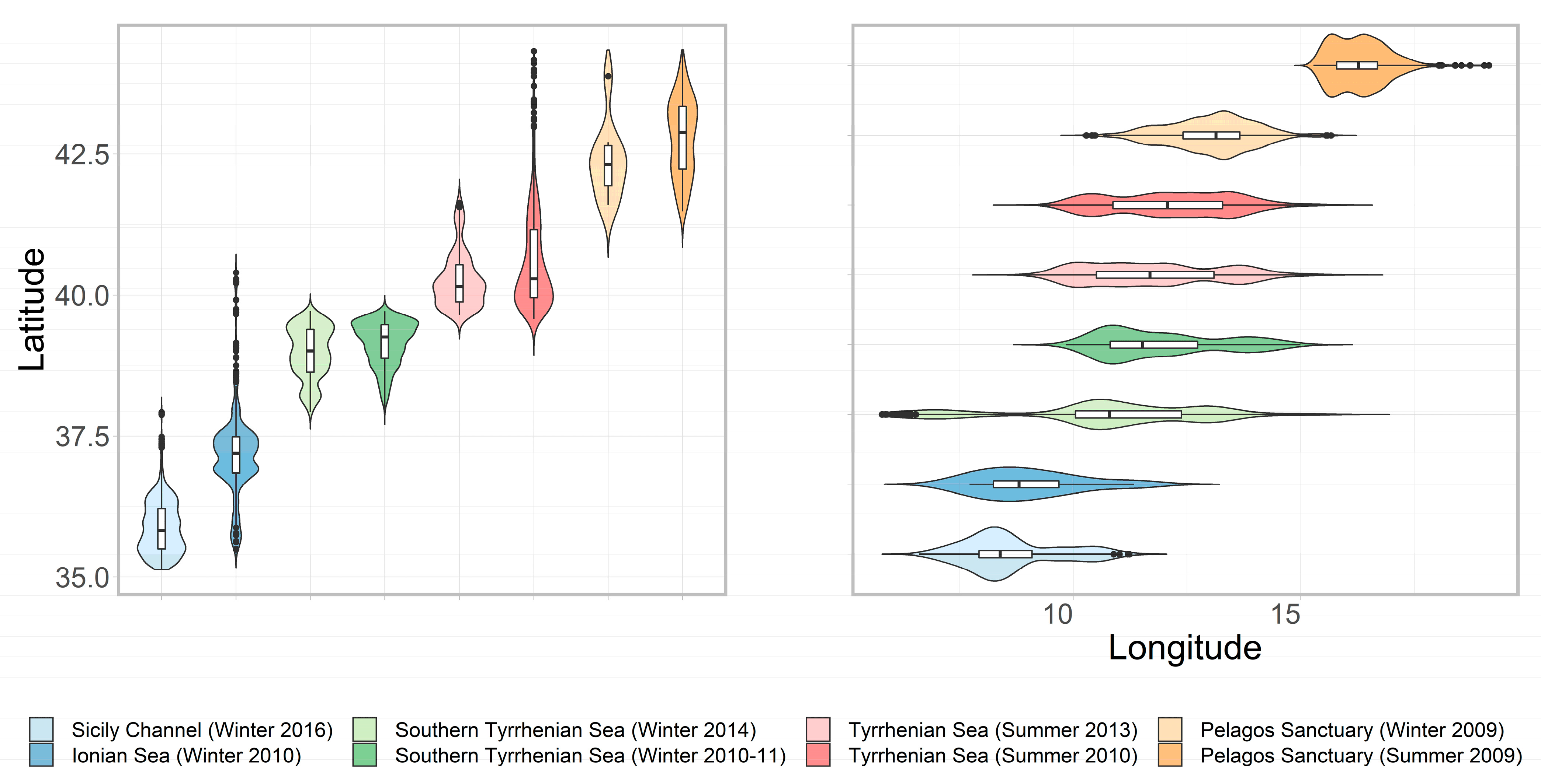
3.1. Sightings and Effort

In total, eight surveys took place between 2009 and 2016. In 2009, the Pelagos Sanctuary was surveyed during the winter and the summer seasons. During 2010, the Ionian Sea and a large block including the Pelagos Sanctuary, the Seas of Corsica and Sardinia (hereafter referred to as the “Extended Pelagos Area”) and the northern Tyrrhenian Sea were monitored in winter and summer, respectively. The southern Tyrrhenian Sea was surveyed twice during the winter season, in 2010–2011 and in 2014, while the Sicily Strait was monitored during winter 2016.
The results of the analysis of the 2009 winter and summer surveys in the Pelagos Sanctuary are presented in Lauriano et al. [35]. Here, we refer and quote those results to allow for comparisons with surveys carried out between 2010 and 2016.
Overall, 5906 loggerhead turtle sightings (Figure 2 and Figure 3) were recorded between 2009 and 2016, with the highest number of observations recorded in the Ionian Sea and the Sicily Strait in winter 2010 and 2016, respectively. The turtles’ encounter rate, expressed as number of groups of turtles per kilometer of positive effort on transects, ranged between 0.01 and 0.11, with the highest values obtained from the Ionian Sea and the south Tyrrhenian Sea (Winter 2014) (Table 2). A latitudinal and longitudinal gradient is evident in the distribution of turtle sightings (Figure 4), with a generally higher occurrence of turtles at lower latitudes and higher longitudes.

3.2. Abundance Estimates

After excluding sightings with no declination angle and/or sightings with missing group size information, and after right truncation, 5177 sightings were considered in the CDS analysis. Details on model selection are summarized in Table 2.
For the summer surveys, the overall highest abundance was estimated from the northern Tyrrhenian Sea survey (n = 12,912; %CV = 13.3), followed by the Extended Pelagos Area survey (n = 33,981; %CV = 15.4) and the Pelagos Sanctuary survey (n = 1905; %CV = 16.2). The latter was monitored in 2009 and 2010—as part of the Extended Pelagos Area—with an estimated abundance being higher in 2009. The northern Tyrrhenian Sea was surveyed in 2010—as part of the Extended Pelagos Area—and 2013; it presented the highest abundance in 2010.
Amongst the winter surveys, the highest abundance was estimated for the Sicily Strait surveyed in 2016 (n = 100,571; CV = 4%), followed by the Ionian Sea (n = 35,434; CV = 16.7%) monitored in 2010. The Pelagos Sanctuary, monitored in 2009, conversely, shows the lowest abundance (n = 237; CV = 34.33%) of loggerhead turtles (Lauriano et al., 2011 [35]), with values being about 300 times lower than the Sicily Strait. In the southern Tyrrhenian Sea, surveyed twice in 2010–2011 and in 2014, the estimated abundance and densities are substantially higher in the latter period (2010–2011 survey: n = 17,972; CV = 20.7%; 2014 survey: n = 33,217; CV = 10.9%).
In the Pelagos Sanctuary, the only area surveyed in both winter (2009) and summer (2009 and 2010), results show higher abundance for the summer surveys. Table 2 summarizes the results of the distance sampling analysis and presents both uncorrected and corrected estimates for each survey.

3.3. Turtles Usage Areas

Overall, high turtle usage areas were found in the central, southern and eastern sectors across the entire monitored area, primarily encompassing deep pelagic waters, and occurred at lower latitudes and higher longitudes, irrespective of the season or year. Winter maximum values of usage are double than the highest summer ones. In particular, the results of the UD analysis highlight two areas intensely used by sea turtles distributed across the central deepest portion of the Sicily Strait and the south-western sector of the Ionian Sea (Figure 2 and Figure 3). Important areas of loggerhead presence also occur in the central, deeper portion of the southern Tyrrhenian Sea stratum, monitored in winter 2010–2011 and 2014, for both survey years, with a slight shift in the occurrence of turtles between the two surveys. In particular, for the 2014 survey, areas of intense usage emerge in the south-western portion of the area between south-eastern Sardinia and north-western Sicily and, to a lesser extent, in the deep northern portion of the stratum, as for the 2010–2011 survey (Figure 3).
When considering the summer surveys, despite an overall lower presence of turtles in the monitored areas when compared with the winter ones, the areas with higher usage can be located in the deeper portion of the Ligurian Sea for the 2009 survey in the Pelagos Sanctuary, and in the deeper waters of the northern Tyrrhenian Sea, located in the central-southern portion of the stratum (Figure 2). For the Pelagos Sanctuary, surveyed in 2009 and in 2010, a stark difference emerged between the two years, with relatively fewer sightings recorded in 2010 than in 2009 (Figure 2) and a consequent absence of high usage area in this portion of the northwestern Mediterranean for the later survey. The northern Tyrrhenian Sea, also surveyed twice in 2010 and 2013, while presenting a relatively higher number of sightings for the 2010 survey, seems to host a stable turtle high usage area in its central and deeper portion.

3.4. Turtle Potential Biological Removal

The PBR calculated on the minimum population abundance (i.e., uncorrected estimates) ranged between 30.48 and 1609.14 individuals for a recovery factor of 0.5 and between 60.96 and 3218.27 individuals for a recovery factor of 1. The highest values were obtained for the Sicily Strait monitored in winter 2016. As expected, being the PBR proportional to the estimated abundance, the same patterns emerge when considering the upper and lower confidence intervals for the uncorrected estimates as well as the adjusted estimates. Table 3 summarizes the calculated PBR values for each study area and recovery factor.

4. Discussion

The conservation status of Mediterranean Sea loggerhead turtles was recently down-listed and the species is currently classified as Least concern [8]. Nonetheless, high bycatch rates reported across the entire basin are still considered unsustainable and represent a serious threat to the persistence of the species in the region [10]. While consistent research effort has been allocated to understand loggerhead turtle ecology in the region, most of this research has been carried out in coastal waters. Aerial surveys are useful for assessing large, highly mobile marine vertebrates. However, these surveys usually have relatively restricted temporal coverage, which limits the range of hypotheses that can be tested. Our surveys were conducted during the summer and winter months, with only one area, the Pelagos Sanctuary, surveyed in both seasons. This spatial and temporal uneven distribution of effort prevents meaningful comparisons of seasonal distribution of loggerhead turtles in the monitored area and the ability to evaluate shifts in the species occurrence and assess seasonal trends in abundance and density. However, our study provides new knowledge on the presence of loggerhead turtles in offshore areas which are usually scarcely monitored, although crucial to assess the bulk of the population. This information is particularly relevant to inform conservation and management activities and represent an important first contribution towards the MSFD criteria related to bycatch, abundance and range [66].

4.1. Loggerhead Turtle Abundance—Results and Limitations

Three species of sea turtles occur in the Mediterranean Sea. While the morphology, size and coloration of leatherbacks strongly differ from those of loggerhead turtles, thus preventing species misidentification, the characteristics of green turtles might render species identification difficult during aerial surveys. However, green turtles primarily occur in the Levantine Basin and, in general, in the eastern Mediterranean region [7]. Accordingly, given the geographic extent of our surveys, we considered all sightings to be of loggerhead turtles.
The Mediterranean hosts turtles from different rookeries [67], and a mixture of surface currents and habitat selection [41] leads to a clear pattern of usage of foraging grounds by juvenile sea turtles from these rookeries. In particular, the areas monitored seem to be inhabited primarily by turtles of Mediterranean origin from Lebanese and Greek rookeries [67,68,69]. We therefore assume that the estimates presented here concern turtles belonging to the Mediterranean Regional Management Unit.
This study highlights an overall north-to-south and west-to-east gradient in the density and abundance of loggerhead turtles across the entire monitored area. This gradient can be explained in part by the oceanographic characteristics of the study areas that, in turn, affect prey distribution and the occurrence of turtles [70], but also by the influence of water temperature which might push some animals to move towards or aggregate in warmer southern regions during the winter [51]. The highest occurrence of turtles in the southern and eastern strata might also result from surface circulation distributing juvenile individuals from nesting areas to the feeding grounds [68]. Animals originating from rookeries in Greece spread, in fact, in both the Sicily Strait and the Ionian Sea, which are described as important foraging grounds [57,71]. The same pattern is recognized to occur for the individuals originating from Libya, which are then hosted in the Ionian and in the Tyrrhenian Seas [68] and by animals originating from Greece, Crete and western Turkey, which can eventually reach the Provençal coast and waters off France [69]. Finally, it is important to consider that given the known presence of loggerhead turtles of Atlantic origin in both the Strait of Sicily and the Ionian Sea [72,73], we cannot exclude that a portion of the animals observed in these two areas do not belong to the Mediterranean RMU and have somewhat contributed to the higher abundance in these two sectors.
While most of our surveys were conducted in different years and seasons, some areas were monitored more than once in different seasons and/or years, allowing for comparisons. Estimates (Table 2) for the Pelagos Sanctuary show that, overall, this portion of the Mediterranean Sea hosts the lowest number of turtles across the monitored areas and that numbers increase in the summer months, with estimates being one order of magnitude higher in summer. For the summer, despite slightly higher estimates derived from the 2009 survey, numbers are comparable and show a constant presence of loggerhead turtles in the area, although at low densities. This is also true for the northern Tyrrhenian Sea, where no changes between the two surveys are apparent. Turtles also seem to occur consistently in the southern Tyrrhenian Sea, with an evident higher abundance in 2014. This difference could be due to the fact that the first survey carried out in the area in 2010–2011 was interrupted and then resumed after 16 weeks due to rough weather and sea conditions, which might have allowed for a redistribution of the animals in the area and affected their presence and the following estimates.
The abundance estimates have been corrected for availability bias only. Our choice of using distinct correction factors is based on the fact that in the Mediterranean, tagging effort has been unevenly allocated across the basin [50,51,52,55,56,57] and a single overall correction factor could have led to strongly biased estimates. Considering this, we stress the need for further systematic research into the diving patterns of loggerhead turtles across the basin allowing for the development of robust correction factors for abundance estimates in this species.
Loggerhead turtles have complex life history traits associated with dramatic ontogenic changes [74,75] that can affect the detectability of animals and bias estimates. Overall, in this study, roughly 83% of the monitored waters extended beyond the continental shelf (depth > 200 m; Figure S2) and variability exists amongst study blocks. Accordingly, the imbalance in the time spent searching in each habitat might have led to an imbalance in the proportion of animals sampled in each life stage. In this light, although difficult during multi-species aerial surveys, future monitoring programs should explore the feasibility of a different design that takes into consideration the ecological aspects related to ontological stages of loggerhead turtles.
Another potential source of bias in our estimates is the fact that some smaller turtles could have been missed given the flight altitude and speed. Recent estimates of surface litter in the Mediterranean [76] used a minimum detectable size of 30 cm for litter items to derive estimates of macro-litter abundance. In our surveys, we estimate that loggerhead turtles of about 20 cm of Curve Carapace Length (CCL) could be spotted. This assumption is based on the fact that the probability to detect a turtle does not only depend on its carapace size but also on the fact that animals’ flippers and head were usually spotted, increasing the overall observable size and on the fact that turtles were commonly observed in motion while surfacing or starting a dive, again increasing their detectability. Evidence suggests that Mediterranean loggerhead turtles of ≤30 cm CCL are within the first four years of life and specifically that turtles of about 20 cm CCL are about 1.5 years old [77,78]. Based on this assumption and on the knowledge of loggerhead turtle population demographic characteristics and age structure [12], we consider missing a relatively small portion of the turtles.

4.2. Sea Turtle Usage Areas

This study shows a striking difference in the presence of loggerhead turtles across the studied area, with strong latitudinal and longitudinal gradients in the occurrence and distribution of sightings (Figure 2, Figure 3 and Figure 4). This gradient reflects the general gradient of mean annual sea surface temperature in the Mediterranean [79] and shows that sea turtles are not geographically randomly distributed but tend to occupy preferred temperature ranges which vary seasonally [80].
The distribution of the sightings highlights a strong depth stratification, with a small fraction of the sightings occurring along the continental shelf (depth ≤ 200 m; n = 556, 9.1%) and most of the sightings occurring at depths between 200 and 1000 (n = 1733, 26.2%) and between 2000 and 3000 (n = 1761, 26.6%) meters (Figure 5). This imbalance in the occurrence of sea turtles in coastal and oceanic habitats strongly matches habitat availability in the monitored areas. However, the depth stratification within oceanic habitats might reflect in part the exchange of turtles between the coastal and oceanic habitats (peak of occurrence between 200 and 1000 m of depth) and in part the fact that hatchlings drift to deep pelagic waters after incubation and remain there for several years without coming to shore (peak at depth greater than 2000 m). While it is well known that turtles in the early juvenile oceanic life-stage represent most of the population and this can explain the high occurrence of sea turtles in the deepest portions of the monitored areas, little knowledge exists on the rates of movements between neritic and oceanic habitats and the rates of loggerhead turtles relocating to nearshore habitats following the pelagic stage.
The location of high usage areas in the Sicily Strait and the south-western portion of the Ionian Sea strata, and to a lesser extent the southern Tyrrhenian Sea, reflects the distribution of both stable and sporadic nesting sites for the species [7,82,83] as well as the location of known foraging grounds for juvenile loggerhead turtles [7]. However, while the Sicily Strait and the easternmost portion of the southern Tyrrhenian Sea are well known pelagic summer grounds, our results suggest a high year-round occurrence of loggerheads in these areas. This, in turn, further complements previous studies highlighting the Tunisian shelf as an important hot-spot for sea turtles [84]. The highest presence of turtles in these areas could also be explained by the fact that the Sicily Strait, in part the Ionian Sea, and more in general the north African coast represent a preferred migratory corridor for turtles that flock from the eastern Mediterranean rockeries towards oceanic grounds in the central basin [51]. This pattern of occurrence of high usage areas in the deeper portions of all the monitored areas, irrelevant of the year or season, strongly reflects the surface circulation of the Mediterranean [85,86,87,88,89], where the north and southern branches of the Algerian Current and the associated gyres in the Tyrrhenian Sea and the Sicily Strait not only aggregate food resources and therefore affect the presence of turtles, but also tend to push and aggregate smaller individuals which drift with the current [90,91,92].
Finally, when comparing our results with a previous Aqua Map model of sea turtle distribution in the Mediterranean Sea developed by [93], with the exception of the Sicily Strait area, very little overlap exists between the predicted distribution by Coll and colleagues [93] and our results. However, these differences should not be considered as a disagreement between the results of the two studies but most likely the effect of different methodological approaches. The predicted turtle distribution by Coll et al., [93] is primarily based on nesting beach data and does not reflect the actual presence of animals at sea. This further calls attention to the necessity of integrating different data sources to obtain a robust and overall picture of loggerhead turtle presence in the region.

4.3. Potential Biological Removal (PBR)

The calculation of PBR values is a way to identify management goals for a given population on the base of simple assumptions, provided that baseline abundance estimates of the target species are available.
The PBR values obtained in this study for both corrected and uncorrected estimates and associated confidence intervals are lower than the bycatch rates reported in portions of the monitored area [13], supporting previous concerns that the mortality of loggerhead turtles in commercial fisheries alone is likely unsustainable in the Mediterranean Sea [10]. While these findings are relevant to management and conservation, caution is needed when interpreting PBR values. When comparing our results with the bycatch rates reported by [13], it is evident that the surveys were conducted in different seasons and the study areas do not fully overlap. While, to ease comparisons, further mathematical exercises are possible to extrapolate abundance estimates and PBRs to areas not directly surveyed, this approach is discouraged. Abundance estimates and thus PBR values extrapolated to non-surveyed areas can be strongly biased due to the fact that the correlates between species densities and covariates in extrapolated areas are unknown [94,95]. It is also important to stress that bycatch rates are often biased (i.e., under-reported [13]) and this adds further difficulties in understanding the actual contribution of commercial fisheries to loggerhead turtle mortality in support of management and conservation. Finally, the presence in the Mediterranean Sea of turtles of different origins introduces a further level of complexity in understanding the actual size of the Mediterranean loggerhead turtles’ RMU and how it is affected by bycatch.
All these elements once again stress the need for future surveys covering the full geographic extent of the Mediterranean loggerhead turtles’ RMU and the integration of different approaches and methodologies to resolve uncertainty in abundance and obtain range-wide PBR estimates.

5. Conclusions

Regional sea conventions available on a Mediterranean scale are necessary tools to ensure that a robust legal framework exists to support management decisions. Nevertheless, it is important to emphasize that ad hoc efforts are urgently needed to bridge the gap between scientists and the fishing industry to ensure a rapid progression into policy and effective conservation. Despite the limitations acknowledged in the above paragraphs, the information provided here poses the basis for more targeted bycatch management efforts. Given the broad spatial scale of this study, our results could be considered in regional planning efforts such as the EBSA [96] and the EcAp processes, as well as the EU MSFD. Our results also support the Important Marine Turtle Areas (IMTAs) process for loggerheads in the Mediterranean region [97].
The abundance estimates, the derived PBR and the loggerhead turtle UDs may contribute to establish, at sub regional scale, the threshold values requested for the Criteria D1C1 (mortality rate from incidental bycatch), D1C2 (population abundances are not adversely affected by anthropogenic pressure), D1C4 (distributional range in line with ecological conditions) and D1C5 (necessary habitat extent), under the umbrella of the MSFD.

Supplementary Materials

The following supporting information can be downloaded at: https://0-www-mdpi-com.brum.beds.ac.uk/article/10.3390/d15121159/s1, Figure S1. Overall monitored area between 2009 and 2916 with highlighted overlapping portion of Marine Subregions as delineated under the Marine Strategy Framework Directive. Geodatabases used to produce the map available at https://www.eea.europa.eu/data-and-maps/data/europe-seas-1 (accessed on 4 October 2023); Figure S2. Depth of the overall surveyed area classified in coastal (depth between 0 and 200 meters) and deep waters (depth greater than 200 meters). Depth reclassification was based on the ETOPO1 Global Relief Model [81]; Figure S3. Detection functions for Conventional Distance Sampling (CDS) analysis for each survey and area. Details on selected models are provided in Table 3. A = Extended Pelagos Area (2010); B = Sicily Channel (2016); C = Central Tyrrhenian Sea (2010); D = Central Tyrrhenian Sea (2013); E = Ionian sea (2010); F = Pelagos Sanctuary (2010); G= Southern Tyrrhenian Sea (2010-2011); H = Southern Tyrrhenian Sea (2014). For the detection functions and related information for the 2009 winter and summer surveys refer to Lauriano et al., [35].

Author Contributions

Conceptualization and design: S.P., G.L. and N.P.; Data collection: N.P., S.P. and G.L.; Analysis execution: N.P. and G.L.; Writing of original draft: N.P.; Manuscript reviewing and editing: N.P., S.P. and G.L.; Funding acquisition: S.P. and G.L. All authors have read and agreed to the published version of the manuscript.

Funding

Financial support to carry out the monitoring activities was provided by the Italian Ministry for Ecological Transition (formerly the Italian Ministry of the Environment, Land and Sea). Grant numbers: DPN-2007-00246167 (11/09/2007), 0025763/PNM (15/12/2014), 0036583/PNM (16/05/2013), 0001302/PNM (27/01/2015).

Institutional Review Board Statement

Not applicable.

Data Availability Statement

The dataset of loggerhead turtle sightings analyzed during the current study are available from the corresponding author on reasonable request.

Acknowledgments

We are grateful to Mach014 and Aeronike and to the pilots (in particular Michele Albertario) of the planes for their high professionalism. Margherita Zanardelli, Lea David and Joan Gonzalvo participated in the data collection. Sonja Eisfeld-Pierantonio and Andrew DiMatteo commented on an early draft of the manuscript. Ana Cañadas advised on distance sampling analyses and Francesco Ventura provided support for the Utilization Distribution analyses. Greg Donovan played a crucial role in the development of the monitoring program and supported it with continuous advice throughout.

Conflicts of Interest

The authors declare no conflict of interest.

References

  1. Barnes, M.D.; Craigie, I.D.; Harrison, L.B.; Geldmann, J.; Collen, B.; Whitmee, S.; Balmford, A.; Burgess, N.D.; Brooks, T.; Hockings, M.; et al. Wildlife Population Trends in Protected Areas Predicted by National Socio-Economic Metrics and Body Size. Nat. Commun. 2016, 7, 12747. [Google Scholar] [CrossRef] [PubMed]
  2. Kristensen, T.V.; Kovach, A.I. Spatially Explicit Abundance Estimation of a Rare Habitat Specialist: Implications for SECR Study Design. Ecosphere 2018, 9, e02217. [Google Scholar] [CrossRef]
  3. Burgar, J.M.; Stewart, F.E.C.; Volpe, J.P.; Fisher, J.T.; Burton, A.C. Estimating Density for Species Conservation: Comparing Camera Trap Spatial Count Models to Genetic Spatial Capture-Recapture Models. Glob. Ecol. Conserv. 2018, 15, e00411. [Google Scholar] [CrossRef]
  4. Wallace, B.P.; DiMatteo, A.D.; Bolten, A.B.; Chaloupka, M.Y.; Hutchinson, B.J.; Abreu-Grobois, F.A.; Mortimer, J.A.; Seminoff, J.A.; Amorocho, D.; Bjorndal, K.A.; et al. Global Conservation Priorities for Marine Turtles. PLoS ONE 2011, 6, e24510. [Google Scholar] [CrossRef]
  5. Lewison, R.L.; Freeman, S.A.; Crowder, L.B. Quantifying the Effects of Fisheries on Threatened Species: The Impact of Pelagic Longlines on Loggerhead and Leatherback Sea Turtles. Ecol. Lett. 2004, 7, 221–231. [Google Scholar] [CrossRef]
  6. Hamann, M.; Godfrey, M.; Seminoff, J.; Arthur, K.; Barata, P.; Bjorndal, K.; Bolten, A.; Broderick, A.; Campbell, L.; Carreras, C.; et al. Global Research Priorities for Sea Turtles: Informing Management and Conservation in the 21st Century. Endanger. Species Res. 2010, 11, 245–269. [Google Scholar] [CrossRef]
  7. Casale, P.; Broderick, A.; Camiñas, J.; Cardona, L.; Carreras, C.; Demetropoulos, A.; Fuller, W.; Godley, B.; Hochscheid, S.; Kaska, Y.; et al. Mediterranean Sea Turtles: Current Knowledge and Priorities for Conservation and Research. Endanger. Species Res. 2018, 36, 229–267. [Google Scholar] [CrossRef]
  8. Casale, P. Caretta caretta (Mediterranean subpopulation). The IUCN Red List of Threatened Species 2015: E.T83644804A83646294. 2015. Available online: https://www.iucnredlist.org/species/83644804/83646294 (accessed on 23 October 2023).
  9. Lucchetti, A.; Sala, A. An Overview of Loggerhead Sea Turtle (Caretta caretta) Bycatch and Technical Mitigation Measures in the Mediterranean Sea. Rev. Fish Biol. Fish. 2010, 20, 141–161. [Google Scholar] [CrossRef]
  10. Casale, P.; Heppell, S. How Much Sea Turtle Bycatch Is Too Much? A Stationary Age Distribution Model for Simulating Population Abundance and Potential Biological Removal in the Mediterranean. Endanger. Species Res. 2016, 29, 239–254. [Google Scholar] [CrossRef]
  11. Wallace, B.P.; Kot, C.Y.; DiMatteo, A.D.; Lee, T.; Crowder, L.B.; Lewison, R.L. Impacts of Fisheries Bycatch on Marine Turtle Populations Worldwide: Toward Conservation and Research Priorities. Ecosphere 2013, 4, art40. [Google Scholar] [CrossRef]
  12. Casale, P. Sea Turtle By-Catch in the Mediterranean: Sea Turtle by-Catch in the Mediterranean. Fish Fish. 2011, 12, 299–316. [Google Scholar] [CrossRef]
  13. Lucchetti, A.; Vasapollo, C.; Virgili, M. An Interview-Based Approach to Assess Sea Turtle Bycatch in Italian Waters. PeerJ 2017, 5. [Google Scholar] [CrossRef] [PubMed]
  14. Lucchetti, A.; Vasapollo, C.; Virgili, M. Sea Turtles Bycatch in the Adriatic Sea Set Net Fisheries and Possible Hot-Spot Identification. Aquat. Conserv. Mar. Freshw. Ecosyst. 2017, 27, 1176–1185. [Google Scholar] [CrossRef]
  15. Clusa, M.; Carreras, C.; Pascual, M.; Gaughran, S.J.; Piovano, S.; Avolio, D.; Ollano, G.; Fernández, G.; Tomás, J.; Raga, J.A.; et al. Potential Bycatch Impact on Distinct Sea Turtle Populations Is Dependent on Fishing Ground Rather than Gear Type in the Mediterranean Sea. Mar. Biol. 2016, 163, 122. [Google Scholar] [CrossRef]
  16. Houghton, J.D.R. Potential Bycatch Impact on Distinct Sea Turtle Populations Is Dependent on Fishing Ground Rather than Gear Type in the Mediterranean Sea: Editorial Comment on the Feature Article by Clusa et al. (2016). Mar. Biol. 2016, 163, 121. [Google Scholar] [CrossRef]
  17. Rees, A.; Alfaro-Shigueto, J.; Barata, P.; Bjorndal, K.; Bolten, A.; Bourjea, J.; Broderick, A.; Campbell, L.; Cardona, L.; Carreras, C.; et al. Are We Working towards Global Research Priorities for Management and Conservation of Sea Turtles? Endanger. Species Res. 2016, 31, 337–382. [Google Scholar] [CrossRef]
  18. Braun McNeill, J.; Goodman Hall, A.; Richards, P. Trends in Fishery-Dependent Captures of Sea Turtles in a Western North Atlantic Foraging Region. Endanger. Species Res. 2018, 36, 315–324. [Google Scholar] [CrossRef]
  19. Troëng, S.; Chacón, D.; Dick, B. Possible Decline in Leatherback Turtle Dermochelys Coriacea Nesting along the Coast of Caribbean Central America. Oryx 2004, 38, 395–403. [Google Scholar] [CrossRef]
  20. Kaplan, I.C. A Risk Assessment for Pacific Leatherback Turtles (Dermochelys coriacea). Can. J. Fish. Aquat. Sci. 2005, 62, 1710–1719. [Google Scholar] [CrossRef]
  21. Broderick, A.C.; Frauenstein, R.; Glen, F.; Hays, G.C.; Jackson, A.L.; Pelembe, T.; Ruxton, G.D.; Godley, B.J. Are Green Turtles Globally Endangered? Glob. Ecol. Biogeogr. 2006, 15, 21–26. [Google Scholar] [CrossRef]
  22. Pfaller, J.B.; Bjorndal, K.A.; Chaloupka, M.; Williams, K.L.; Frick, M.G.; Bolten, A.B. Accounting for Imperfect Detection Is Critical for Inferring Marine Turtle Nesting Population Trends. PLoS ONE 2013, 8, e62326. [Google Scholar] [CrossRef] [PubMed]
  23. Broderick, A.C.; Godley, B.J.; Hays, G.C. Trophic Status Drives Interannual Variability in Nesting Numbers of Marine Turtles. Proc. R. Soc. Lond. B Biol. Sci. 2001, 268, 1481–1487. [Google Scholar] [CrossRef] [PubMed]
  24. Esteban, N.; Mortimer, J.A.; Hays, G.C. How Numbers of Nesting Sea Turtles Can Be Overestimated by Nearly a Factor of Two. Proc. R. Soc. B Biol. Sci. 2017, 284, 20162581. [Google Scholar] [CrossRef] [PubMed]
  25. Ceriani, S.A.; Casale, P.; Brost, M.; Leone, E.H.; Witherington, B.E. Conservation Implications of Sea Turtle Nesting Trends: Elusive Recovery of a Globally Important Loggerhead Population. Ecosphere 2019, 10, e02936. [Google Scholar] [CrossRef]
  26. Warden, M.L.; Haas, H.L.; Richards, P.M.; Rose, K.A.; Hatch, J.M. Monitoring Trends in Sea Turtle Populations: Walk or Fly? Endanger. Species Res. 2017, 34, 323–337. [Google Scholar] [CrossRef]
  27. Shoop, C.R.; Kenney, R.D. Seasonal Distributions and Abundances of Loggerhead and Leatherback Sea Turtles in Waters of the Northeastern United States. Herpetol. Monogr. 1992, 6, 43–67. [Google Scholar] [CrossRef]
  28. Epperly, S.P.; Braun, J.; Veishlow, A. Sea Turtles in North Carolina Waters. Conserv. Biol. 1995, 9, 384–394. [Google Scholar] [CrossRef]
  29. Witt, M.J.; Baert, B.; Broderick, A.C.; Formia, A.; Fretey, J.; Gibudi, A.; Mounguengui, G.A.M.; Moussounda, C.; Ngouessono, S.; Parnell, R.J.; et al. Aerial Surveying of the World’s Largest Leatherback Turtle Rookery: A More Effective Methodology for Large-Scale Monitoring. Biol. Conserv. 2009, 142, 1719–1727. [Google Scholar] [CrossRef]
  30. Bovery, C.M.; Wyneken, J. Seasonal Variation in Sea Turtle Density and Abundance in the Southeast Florida Current and Surrounding Waters. PLoS ONE 2015, 10, e0145980. [Google Scholar] [CrossRef]
  31. Eguchi, T.; McClatchie, S.; Wilson, C.; Benson, S.R.; LeRoux, R.A.; Seminoff, J.A. Loggerhead Turtles (Caretta caretta) in the California Current: Abundance, Distribution, and Anomalous Warming of the North Pacific. Front. Mar. Sci. 2018, 5, 452. [Google Scholar] [CrossRef]
  32. Barco, S.; Burt, M.; DiGiovanni, R.; Swingle, W.; Williard, A. Loggerhead Turtle Caretta caretta Density and Abundance in Chesapeake Bay and the Temperate Ocean Waters of the Southern Portion of the Mid-Atlantic Bight. Endanger. Species Res. 2018, 37, 269–287. [Google Scholar] [CrossRef]
  33. Panigada, S.; Lauriano, G.; Donovan, G.; Pierantonio, N.; Cañadas, A.; Vázquez, J.A.; Burt, L. Estimating Cetacean Density and Abundance in the Central and Western Mediterranean Sea through Aerial Surveys: Implications for Management. Deep Sea Res. Part II Top. Stud. Oceanogr. 2017, 141, 41–58. [Google Scholar] [CrossRef]
  34. Panigada, S.; Lauriano, G.; Burt, L.; Pierantonio, N.; Donovan, G. Monitoring Winter and Summer Abundance of Cetaceans in the Pelagos Sanctuary (Northwestern Mediterranean Sea) Through Aerial Surveys. PLoS ONE 2011, 6, e22878. [Google Scholar] [CrossRef] [PubMed]
  35. Lauriano, G.; Panigada, S.; Casale, P.; Pierantonio, N.; Donovan, G. Aerial Survey Abundance Estimates of the Loggerhead Sea Turtle Caretta caretta in the Pelagos Sanctuary, Northwestern Mediterranean Sea. Mar. Ecol. Prog. Ser. 2011, 437, 291–302. [Google Scholar] [CrossRef]
  36. Lauriano, G.; Pierantonio, N.; Donovan, G.; Panigada, S. Abundance and Distribution of Tursiops truncatus in the Western Mediterranean Sea: An Assessment towards the Marine Strategy Framework Directive Requirements. Mar. Environ. Res. 2014, 100, 86–93. [Google Scholar] [CrossRef]
  37. Lauriano, G.; Pierantonio, N.; Kell, L.; Cañadas, A.; Donovan, G.; Panigada, S. Fishery-Independent Surface Abundance and Density Estimates of Swordfish (Xiphias gladius) from Aerial Surveys in the Central Mediterranean Sea. Deep Sea Res. Part II Top. Stud. Oceanogr. 2017, 141, 102–114. [Google Scholar] [CrossRef]
  38. Laran, S.; Pettex, E.; Authier, M.; Blanck, A.; David, L.; Dorémus, G.; Falchetto, H.; Monestiez, P.; Van Canneyt, O.; Ridoux, V. Seasonal Distribution and Abundance of Cetaceans within French Waters—Part I: The North-Western Mediterranean, Including the Pelagos Sanctuary. Deep Sea Res. Part II Top. Stud. Oceanogr. 2017, 141, 20–30. [Google Scholar] [CrossRef]
  39. DiMatteo, A.; Cañadas, A.; Roberts, J.; Sparks, L.; Panigada, S.; Boisseau, O.; Moscrop, A.; Fortuna, C.M.; Lauriano, G.; Holcer, D.; et al. Basin-Wide Estimates of Loggerhead Turtle Abundance in the Mediterranean Sea Derived from Line Transect Surveys. Front. Mar. Sci. 2022, 9, 930412. [Google Scholar] [CrossRef]
  40. Gómez de Segura, A.; Tomás, J.; Pedraza, S.N.; Crespo, E.A.; Raga, J.A. Preliminary Patterns of Distribution and Abundance of Loggerhead Sea Turtles, Caretta caretta, around Columbretes Islands Marine Reserve, Spanish Mediterranean. Mar. Biol. 2003, 143, 817–823. [Google Scholar] [CrossRef]
  41. Cardona, L.; Revelles, M.; Carreras, C.; San Félix, M.; Gazo, M.; Aguilar, A. Western Mediterranean Immature Loggerhead Turtles: Habitat Use in Spring and Summer Assessed through Satellite Tracking and Aerial Surveys. Mar. Biol. 2005, 147, 583–591. [Google Scholar] [CrossRef]
  42. Thomas, L.; Buckland, S.T.; Rexstad, E.A.; Laake, J.L.; Strindberg, S.; Hedley, S.L.; Bishop, J.R.B.; Marques, T.A.; Burnham, K.P. Distance Software: Design and Analysis of Distance Sampling Surveys for Estimating Population Size. J. Appl. Ecol. 2010, 47, 5–14. [Google Scholar] [CrossRef] [PubMed]
  43. Notarbartolo di Sciara, G.; Lauriano, G.; Pierantonio, N.; Cañadas, A.; Donovan, G.; Panigada, S. The Devil We Don’t Know: Investigating Habitat and Abundance of Endangered Giant Devil Rays in the North-Western Mediterranean Sea. PLoS ONE 2015, 10, e0141189. [Google Scholar] [CrossRef]
  44. Buckland, S.T.; Rexstad, E.A.; Marques, T.A.; Oedekoven, C.S. Distance Sampling: Methods and Applications; Methods in Statistical Ecology; Springer International Publishing: Cham, Switzerland, 2015; ISBN 978-3-319-19218-5. [Google Scholar]
  45. Pollock, K.H.; Marsh, H.D.; Lawler, I.R.; Alldredge, M.W. Estimating Animal Abundance in Heterogeneous Environments: An Application to Aerial Surveys for Dugongs. J. Wildl. Manag. 2006, 70, 255–262. [Google Scholar] [CrossRef]
  46. Fuentes, M.M.P.B.; Bell, I.; Hagihara, R.; Hamann, M.; Hazel, J.; Huth, A.; Seminoff, J.A.; Sobtzick, S.; Marsh, H. Improving In-Water Estimates of Marine Turtle Abundance by Adjusting Aerial Survey Counts for Perception and Availability Biases. J. Exp. Mar. Biol. Ecol. 2015, 471, 77–83. [Google Scholar] [CrossRef]
  47. Burt, M.L.; Borchers, D.L.; Jenkins, K.J.; Marques, T.A. Using Mark–Recapture Distance Sampling Methods on Line Transect Surveys. Methods Ecol. Evol. 2014, 5, 1180–1191. [Google Scholar] [CrossRef]
  48. Smolensky, N.L.; Fitzgerald, L.A. Population Variation in Dune-Dwelling Lizards in Response to Patch Size, Patch Quality, and Oil and Gas Development. Southwest. Nat. 2011, 56, 315–324. [Google Scholar] [CrossRef]
  49. Nykänen, M.; Jessopp, M.; Doyle, T.K.; Harman, L.A.; Cañadas, A.; Breen, P.; Hunt, W.; Mackey, M.; Cadhla, O.Ó.; Reid, D.; et al. Using Tagging Data and Aerial Surveys to Incorporate Availability Bias in the Abundance Estimation of Blue Sharks (Prionace glauca). PLoS ONE 2018, 13, e0203122. [Google Scholar] [CrossRef]
  50. Hays, G.C.; Webb, P.I.; Hayes, J.P.; Priede, I.G.; French, J. Satellite Tracking of a Loggerhead Turtle (Caretta caretta) in The Mediterranean. J. Mar. Biol. Assoc. U. K. 1991, 71, 743–746. [Google Scholar] [CrossRef]
  51. Bentivegna, F. Intra-Mediterranean Migrations of Loggerhead Sea Turtles (Caretta caretta) Monitored by Satellite Telemetry. Mar. Biol. 2002, 141, 795–800. [Google Scholar] [CrossRef]
  52. Godley, B.J.; Broderick, A.C.; Glen, F.; Hays, G.C. Post-Nesting Movements and Submergence Patterns of Loggerhead Marine Turtles in the Mediterranean Assessed by Satellite Tracking. J. Exp. Mar. Biol. Ecol. 2003, 287, 119–134. [Google Scholar] [CrossRef]
  53. Broderick, A.C.; Coyne, M.S.; Fuller, W.J.; Glen, F.; Godley, B.J. Fidelity and Over-Wintering of Sea Turtles. Proc. R. Soc. B Biol. Sci. 2007, 274, 1533–1539. [Google Scholar] [CrossRef] [PubMed]
  54. Hochscheid, S.; Bentivegna, F.; Hamza, A.; Hays, G.C. When Surfacers Do Not Dive: Multiple Significance of Extended Surface Times in Marine Turtles. J. Exp. Biol. 2010, 213, 1328–1337. [Google Scholar] [CrossRef]
  55. Luschi, P.; Mencacci, R.; Vallini, C.; Ligas, A.; Lambardi, P.; Benvenuti, S. Long-Term Tracking of Adult Loggerhead Turtles (Caretta caretta) in the Mediterranean Sea. J. Herpetol. 2013, 47, 227–231. [Google Scholar] [CrossRef]
  56. Casale, P.; Mariani, P. The First ‘Lost Year’ of Mediterranean Sea Turtles: Dispersal Patterns Indicate Subregional Management Units for Conservation. Mar. Ecol. Prog. Ser. 2014, 498, 263–274. [Google Scholar] [CrossRef]
  57. Luschi, P.; Casale, P. Movement Patterns of Marine Turtles in the Mediterranean Sea: A Review. Ital. J. Zool. 2014, 81, 478–495. [Google Scholar] [CrossRef]
  58. Chimienti, M.; Blasi, M.F.; Hochscheid, S. Movement Patterns of Large Juvenile Loggerhead Turtles in the Mediterranean Sea: Ontogenetic Space Use in a Small Ocean Basin. Ecol. Evol. 2020, 10, 6978–6992. [Google Scholar] [CrossRef]
  59. Anderson, D.J. The Home Range: A New Nonparametric Estimation Technique. Ecology 1982, 63, 103–112. [Google Scholar] [CrossRef]
  60. Worton, B.J. Kernel Methods for Estimating the Utilization Distribution in Home-Range Studies. Ecology 1989, 70, 164–168. [Google Scholar] [CrossRef]
  61. Calenge, C. The Package “Adehabitat” for the R Software: A Tool for the Analysis of Space and Habitat Use by Animals. Ecol. Model. 2006, 197, 516–519. [Google Scholar] [CrossRef]
  62. Wade, P.R. Calculating Limits to the Allowable Human-Caused Mortality of Cetaceans and Pinnipeds. Mar. Mammal Sci. 1998, 14, 1–37. [Google Scholar] [CrossRef]
  63. Barlow, J.; Swartz, S.L.; Eagle, T.; Wade, P.R. US Marine Mammal Stock Assessments: Guidelines for Preparation, Background, and a Summary of the 1995 Assessments; NOAA Technical Memorandum NMFS-OPR-95-6; U.S. Department of Commerce: Washington, DC, USA, 1995.
  64. Punt, A.E.; Siple, M.; Francis, T.B.; Hammond, P.S.; Heinemann, D.; Long, K.J.; Moore, J.E.; Sepúlveda, M.; Reeves, R.R.; Sigurðsson, G.M.; et al. Robustness of Potential Biological Removal to Monitoring, Environmental, and Management Uncertainties. ICES J. Mar. Sci. 2020, 77, 2491–2507. [Google Scholar] [CrossRef]
  65. Marcovaldi, M.Â.; Chaloupka, M. Conservation Status of the Loggerhead Sea Turtle in Brazil: An Encouraging Outlook. Endanger. Species Res. 2007, 3, 133–143. [Google Scholar] [CrossRef]
  66. Girard, F.; Girard, A.; Monsinjon, J.; Arcangeli, A.; Belda, E.; Cardona, L.; Casale, P.; Catteau, S.; David, L.; Dell’Amico, F.; et al. Toward a Common Approach for Assessing the Conservation Status of Marine Turtle Species within the European Marine Strategy Framework Directive. Front. Mar. Sci. 2022, 9, 790733. [Google Scholar] [CrossRef]
  67. Clusa, M.; Carreras, C.; Pascual, M.; Gaughran, S.J.; Piovano, S.; Giacoma, C.; Fernández, G.; Levy, Y.; Tomás, J.; Raga, J.A.; et al. Fine-Scale Distribution of Juvenile Atlantic and Mediterranean Loggerhead Turtles (Caretta caretta) in the Mediterranean Sea. Mar. Biol. 2014, 161, 509–519. [Google Scholar] [CrossRef]
  68. Clusa, M.; Carreras, C.; Pascual, M.; Demetropoulos, A.; Margaritoulis, D.; Rees, A.F.; Hamza, A.A.; Khalil, M.; Aureggi, M.; Levy, Y.; et al. Mitochondrial DNA Reveals Pleistocenic Colonisation of the Mediterranean by Loggerhead Turtles (Caretta caretta). J. Exp. Mar. Biol. Ecol. 2013, 439, 15–24. [Google Scholar] [CrossRef]
  69. Loisier, A.; Savelli, M.-P.; Arnal, V.; Claro, F.; Gambaiani, D.; Sénégas, J.B.; Cesarini, C.; Sacchi, J.; Miaud, C.; Montgelard, C. Genetic Composition, Origin and Conservation of Loggerhead Sea Turtles (Caretta caretta) Frequenting the French Mediterranean Coasts. Mar. Biol. 2021, 168, 52. [Google Scholar] [CrossRef]
  70. Bentivegna, F.; Valentino, F.; Falco, P.; Zambianchi, E.; Hochscheid, S. The Relationship between Loggerhead Turtle (Caretta caretta) Movement Patterns and Mediterranean Currents. Mar. Biol. 2007, 151, 1605–1614. [Google Scholar] [CrossRef]
  71. Zbinden, J.A.; Aebischer, A.; Margaritoulis, D.; Arlettaz, R. Insights into the Management of Sea Turtle Internesting Area through Satellite Telemetry. Biol. Conserv. 2007, 137, 157–162. [Google Scholar] [CrossRef]
  72. Bolten, A.B.; Martins, H.B.; Bjorndal, K.A.; Cocco, M.; Gerosa, G. Caretta caretta (Loggerhead) Pelagic Movement and Growth. Herpetol. Rev. 1992, 23, 116. [Google Scholar]
  73. Manzella, S.A.; Fontaine, C.T.; Schroeder, B. Loggerhead Seaturtle Travels from Padre Island, Texas, to the Mouth of the Adriatic Sea. Mar. Turt. Newsl. 1998, 42, 7. [Google Scholar]
  74. Musick, J.A.; Limpus, C.J. Habitat Utilization and Migration in Juvenile Sea Turtles. In The Biology of Sea Turtles; Musick, J.A., Lutz, P.L., Eds.; CRC Press: Boca Raton, FL, USA, 1996; pp. 137–155. ISBN 978-0-8493-8422-6. [Google Scholar]
  75. Heppell, S.; Crowder, L.; Crouse, D.; Epperly, S.; Frazer, N. Population Models for Atlantic Loggerheads: Past, Present, and Future. In Loggerhead Sea Turtles; Bolten, A.B., Witherington, B.E., Eds.; Smithsonian Institution Press: Washington, DC, USA, 2003; pp. 255–273. ISBN 978-1-58834-136-5. [Google Scholar]
  76. Lambert, C.; Authier, M.; Dorémus, G.; Laran, S.; Panigada, S.; Spitz, J.; Van Canneyt, O.; Ridoux, V. Setting the Scene for Mediterranean Litterscape Management: The First Basin-Scale Quantification and Mapping of Floating Marine Debris. Environ. Pollut. 2020, 263, 114430. [Google Scholar] [CrossRef] [PubMed]
  77. Casale, P.; Mazaris, A.D.; Freggi, D.; Vallini, C.; Argano, R. Growth Rates and Age at Adult Size of Loggerhead Sea Turtles (Caretta caretta) in the Mediterranean Sea, Estimated through Capture-Mark-Recapture Records. Sci. Mar. 2009, 73, 589–595. [Google Scholar] [CrossRef]
  78. Guarino, F.M.; Di Nocera, F.; Pollaro, F.; Galiero, G.; Iaccarino, D.; Iovino, D.; Mezzasalma, M.; Petraccioli, A.; Odierna, G.; Maio, N. Skeletochronology, Age at Maturity and Cause of Mortality of Loggerhead Sea Turtles Caretta caretta Stranded along the Beaches of Campania (South-Western Italy, Western Mediterranean Sea). Herpetozoa 2020, 33, 39–51. [Google Scholar] [CrossRef]
  79. Minnett, P.J.; Alvera-Azcárate, A.; Chin, T.M.; Corlett, G.K.; Gentemann, C.L.; Karagali, I.; Li, X.; Marsouin, A.; Marullo, S.; Maturi, E.; et al. Half a Century of Satellite Remote Sensing of Sea-Surface Temperature. Remote Sens. Environ. 2019, 233, 111366. [Google Scholar] [CrossRef]
  80. Coles, W.C.; Musick, J.A. Satellite Sea Surface Temperature Analysis and Correlation with Sea Turtle Distribution off North Carolina. Copeia 2000, 2000, 551–554. [Google Scholar] [CrossRef]
  81. Amante, C.; Eakins, B.W. ETOPO1 Global Relief Model Converted to PanMap Layer Format. NOAA Tech. Memorandum NESDIS 2009, 24, 1–19. [Google Scholar] [CrossRef]
  82. Carreras, C.; Pascual, M.; Tomás, J.; Marco, A.; Hochscheid, S.; Castillo, J.J.; Gozalbes, P.; Parga, M.; Piovano, S.; Cardona, L. Sporadic Nesting Reveals Long Distance Colonisation in the Philopatric Loggerhead Sea Turtle (Caretta caretta). Sci. Rep. 2018, 8, 1435. [Google Scholar] [CrossRef]
  83. Katsiyiannis, P. Discovery of the First Feeding Area for Adult and Juvenile Green Turtles and Loggerhead Turtles in Greece. Herpetol. Bull. 2019, 32–33. [Google Scholar] [CrossRef]
  84. Casale, P.; Freggi, D.; Cinà, A.; Rocco, M. Spatio-Temporal Distribution and Migration of Adult Male Loggerhead Sea Turtles (Caretta caretta) in the Mediterranean Sea: Further Evidence of the Importance of Neritic Habitats off North Africa. Mar. Biol. 2013, 160, 703–718. [Google Scholar] [CrossRef]
  85. Robinson, A.R.; Leslie, W.G.; Theocharis, A.; Lascaratos, A. Mediterranean Sea Circulation. In Encyclopedia of Ocean Sciences; Elsevier: Amsterdam, The Netherlands, 2001; pp. 1689–1705. [Google Scholar]
  86. Millot, C.; Taupier-Letage, I. Circulation in the Mediterranean Sea. In The Mediterranean Sea; Saliot, A., Ed.; Handbook of Environmental Chemistry; Springer: Berlin/Heidelberg, Germany, 2005; pp. 29–66. ISBN 978-3-540-31492-9. [Google Scholar]
  87. Woodward, J.C. (Ed.) The Physical Geography of the Mediterranean; Oxford University Press: New York, NY, USA, 2009. [Google Scholar]
  88. Poulain, P.-M.; Menna, M.; Mauri, E. Surface Geostrophic Circulation of the Mediterranean Sea Derived from Drifter and Satellite Altimeter Data. J. Phys. Oceanogr. 2012, 42, 973–990. [Google Scholar] [CrossRef]
  89. Pascual, A.; Vidal-Vijande, E.; Ruiz, S.; Somot, S.; Papadopoulos, V. Spatiotemporal variability of the surface circulation in the western Mediterranean. In The Mediterranean Sea; American Geophysical Union (AGU): Washington, DC, USA, 2014; pp. 5–23. [Google Scholar]
  90. Carr, A. Impact of Nondegradable Marine Debris on the Ecology and Survival Outlook of Sea Turtles. Mar. Pollut. Bull. 1987, 18, 352–356. [Google Scholar] [CrossRef]
  91. Luschi, P.; Hays, G.C.; Papi, F. A Review of Long-Distance Movements by Marine Turtles, and the Possible Role of Ocean Currents. Oikos 2003, 103, 293–302. [Google Scholar] [CrossRef]
  92. Scott, R.; Marsh, R.; Hays, G.C. Ontogeny of Long Distance Migration. Ecology 2014, 95, 2840–2850. [Google Scholar] [CrossRef]
  93. Coll, M.; Piroddi, C.; Steenbeek, J.; Kaschner, K.; Ben Rais Lasram, F.; Aguzzi, J.; Ballesteros, E.; Bianchi, C.N.; Corbera, J.; Dailianis, T.; et al. The Biodiversity of the Mediterranean Sea: Estimates, Patterns, and Threats. PLoS ONE 2010, 5, e11842. [Google Scholar] [CrossRef] [PubMed]
  94. Mannocci, L.; Roberts, J.J.; Halpin, P.N.; Authier, M.; Boisseau, O.; Bradai, M.N.; Cañadas, A.; Chicote, C.; David, L.; Di Méglio, N.; et al. Assessing Cetacean Surveys throughout the Mediterranean Sea: A Gap Analysis in Environmental Space. Sci. Rep. 2018, 8, 3126. [Google Scholar] [CrossRef] [PubMed]
  95. Parra, G.J.; Bilgmann, K.; Peters, K.J.; Möller, L.M. Abundance and Potential Biological Removal of Common Dolphins Subject to Fishery Impacts in South Australian Waters. Front. Mar. Sci. 2021, 8, 617075. [Google Scholar] [CrossRef]
  96. Weaver, P.; Johnson, D. Think Big for Marine Conservation. Nature 2012, 483, 399. [Google Scholar] [CrossRef]
  97. Pilcher, N.J.; Antonopoulou, M.A.; Rodriguez-Zarate, C.J.; Mateos-Molina, D.; Das, H.S.; Bugla, I.; Al Ghais, S.M. Movements of Green Turtles from Foraging Areas of the United Arab Emirates: Regional Habitat Connectivity and Use of Marine Protected Areas. Mar. Biol. 2021, 168, 10. [Google Scholar] [CrossRef]
Figure 1. The area monitored between 2009 and 2016 with the survey strata and transects resulting from the Distance software design. Survey design for the winter and summer 2009 surveys in the Pelagos Sanctuary are available from Lauriano et al. [35]. The map inset with the extent of the monitored area is highlighted in red.
Diversity 15 01159 g001
Figure 2. Summer surveys; for each study area and year, the map on the left shows loggerhead turtle sightings, the map in the center shows the obtained UDs and the map on the left highlights the UD’s 25th and 75th percentile.
Diversity 15 01159 g002
Figure 3. Winter surveys; for each study area and year, the map on the left shows loggerhead turtle sightings, the map in the center shows the obtained UDs and the map on the left highlights the UD’s 25th and 75th percentile.
Diversity 15 01159 g003
Figure 4. Violin plots with included boxplots of turtle sightings’ latitude (left) and longitude (right) per surveyed area showing north–south and west–east gradient in the occurrence of sightings. Wider sections of the violin plots indicate a higher number of sightings at a given latitude or longitude while the skinnier sections indicate a lower occurrence. Boxplots show lower (Q1), median and upper (Q3) quartiles and outliers (black dots).
Diversity 15 01159 g004
Figure 5. Percent frequency distribution of loggerhead turtle sightings at different depths. Bin widths are uneven to show the separation between turtles’ neritic and oceanic habitats. The width of the last bin is based on the highest depth as extracted from the ETOPO1 Global Relief Model [81].
Diversity 15 01159 g005
Table 1. Summary of the information for each surveyed area. “Strata” = number of strata in which each surveyed block has been subdivided; “Extent” = extent of each survey block; “Transects” = total number of transects per block; “Spacing” = linear distance between parallel transects; “Length” = total length of planned survey tracks and “Coverage” = proportion of covered area for each stratum as resulting from survey design.
AreaYearSeasonStrataExtent (km2)TransectsSpacing (km)Length (km)Coverage (%)
Pelagos Sanctuary2009Winter and Summer388,2678210850215.4
Pelagos Sanctuary *2010Summer35415570410.5
Ionian Sea2010Winter197,326381559999.8
Extended Pelagos Area2010Summer7236,2721311519,75310.5
Northern Tyrrhenian Sea2013Summer293,216501562766.73
Northern Tyrrhenian Sea *2010Summer25015610710.5
Southern Tyrrhenian Sea2010–2011Winter3111,147471576466.67
20141576466.67
Strait of Sicily2016Winter1109,709381580837.38
* Surveyed as part of the Extended Pelagos Area.
Table 2. Density and abundance estimates and abundance estimates corrected for availability bias for each survey. ER = encounter rate calculated as number of sightings per km of survey; D = uncorrected density; N = estimated uncorrected abundance; CV = confidence intervals for the estimated uncorrected abundance; 95% CI = lower and upper 95% confidence intervals for the estimated uncorrected abundance; G(0) = applied correction factor for availability bias; Nc = estimated abundance corrected for availability bias; models (best model based on AIC: HN/c = half normal with cosine adjustment; HR/c = hazard rate with cosine adjustment; U/c = uniform with cosine adjustment. Detection functions are provided in the Supplementary Material as Figure S3.
AreaYearSeasonEffort (km)ERSightingsDN (%CV)95% CIG(0)NcSelected Model
Pelagos Sanctuary2009Winter8144.400.00190.0026273 (34.33)122–4610.43634HN/c
Pelagos Sanctuary2009Summer8446.900.0181550.0464083 (14.59)3061–54460.488506HN/c
Ionian Sea2010Winter7921.460.1108900.36435,434 (16.7)25,531–49,1770.4382,404HN/c
Extended Pelagos Area2010Summer19,684.620.0406920.07833,981 (15.4)25,167–45,8800.4870,793U/c
Pelagos Sanctuary *2010Summer6291.700.010620.0221905 (16.2)1387–26160.483968HN/c
Central Tyrrhenian Sea *2010Summer9101.630.0605360.13912,912 (13.3)9140–15,3080.4826,900HR/c
Central Tyrrhenian Sea2013Summer7951.650.0302760.0999253 (20.4)6214–13,7800.4819,277HN/c
Southern Tyrrhenian Sea2010-11Winter7388.980.0604520.17917,972 (20.7)11,931–29,0730.4341,795HN/c
Southern Tyrrhenian Sea2014Winter6689.690.1107370.3333,217 (10.9)26,691–41,3390.4374,248U/c
Sicily Channel2016Winter6325.6030.2919660.665100,571 (4)91,393–110,6690.43233,866HN/c
* Surveyed as part of the Extended Pelagos Area.
Table 3. Summary of PBR calculations for each survey obtained using both uncorrected (N) and corrected (Nc) abundance estimates, lower (L95%CI) and upper (U95%CI) 95% confidence intervals of uncorrected estimates. F = recovery factor. Estimates are not presented for the Pelagos Sanctuary winter survey carried out in 2009 due to the small estimates.
Ionian Sea (Winter 2010)Sicily Channel (Winter 2016)Southern Tyrrhenian Sea (Winter 2010-11)Southern Tyrrhenian Sea (Winter 2014)Northern Tyrrhenian Sea (Summer 2010) *Northern Tyrrhenian Sea (Summer 2013)Extended Pelagos Survey Area (Summer 2010)Pelagos Sanctuary (Summer 2009)Pelagos Sanctuary (Summer 2010) *
F0.501.000.501.000.501.000.501.000.501.000.501.000.501.000.501.000.501.00
N566.941133.891609.143218.27287.55575.10531.471062.94206.59413.18148.05296.10543.701087.3930.4860.9665.32130.65
L95%CI408.50816.991462.292924.58190.90381.79427.06854.11146.24292.4899.42198.85402.67805.3422.1944.3848.9797.95
U95%CI786.831573.661770.73541.41465.17930.34661.421322.85244.93489.86220.48443.84734.081468.1641.8583.1786.97173.95
Nc1318.462636.933741.867483.71668.721337.441187.632375.26430.40860.80308.43616.861132.692265.3863.48126.97136.09272.19
* Surveyed as part of the Extended Pelagos Area.
Disclaimer/Publisher’s Note: The statements, opinions and data contained in all publications are solely those of the individual author(s) and contributor(s) and not of MDPI and/or the editor(s). MDPI and/or the editor(s) disclaim responsibility for any injury to people or property resulting from any ideas, methods, instructions or products referred to in the content.

