Article

Mangroves on the Edge: Anthrome-Dependent Fragmentation Influences Ecological Condition (Turbo, Colombia, Southern Caribbean)

by
Juan Felipe Blanco-Libreros
* and
Edgar Andrés Estrada-Urrea
Instituto de Biología, Universidad de Antioquia, Medellín, Apartado Aéreo 1226, Colombia
*
Author to whom correspondence should be addressed.
Submission received: 1 March 2015 / Revised: 2 June 2015 / Accepted: 5 June 2015 / Published: 26 June 2015
(This article belongs to the Special Issue Mangrove Conservation)

Abstract

:
Marine protected areas are commonly seen as the most effective strategy for protecting mangroves from external human pressures but little is known about the role of public land-tenure contexts (dense settlements, agricultural or range lands and wild anthromes) on clearing rates, patch properties, and ecological condition. We addressed the following questions using a peri-urban to wild gradient along the anthropogenic coastal-scape in Turbo Municipality (Colombia, Southern Caribbean): Do the different deforestation rates observed under peri-urban, rural, military-protected and wild land-use-and-tenure contexts, promote distinctive fragmentation patterns? Do these patterns influence loggers’ access and ultimately ecosystem ecological condition? Loss rate (1938–2009) was the greatest in peri-urban mangroves and positively correlated with urban edge and patch density. Pasture edge was highest in rural mangroves while mean patch area was higher in protected and wild mangroves. An Anthropogenic Disturbance Index (ADI) was strongly correlated with reduced mean patch area and increased patch density, due to increased trampling and logging, that ultimately promoted high densities of thin (diameter: <5 cm) Laguncularia racemosa trees but had no significant effect on the presence of a dominant benthic gastropod. In conclusion, both protection and remoteness were effective in reducing anthropogenic edges and fragmentation, and thus contributed to a high ecological condition in mangroves at a major deforestation hotspot.

1. Introduction

The extensive human transformation of the biosphere imposes new challenges for the conservation of tropical forests [1] including mangroves [2]. Firstly, the plethora of human-transformed biomes or anthromes (sensu [3,4]) suggests that conservation of the natural capital may take place under different spatial contexts observed across the continuum from peri-urban and rural landscapes to remote wilderness areas [1,5]. Along this gradient, different land-tenure contexts are observed in public and private lands, thus imposing different threats to conservation targets. Human threats such as deforestation and hunting are increasingly observed around protected areas immersed in remote, rural, peri-urban and urban matrices. Therefore, new conservation targets such as “hybrid” and “novel” ecosystems are being selected, as a result of the discussions about long-term sustainability, due to the valuable services that they still provide across the anthropogenic biosphere [6,7,8,9]. As a consequence, tropical conservation biologists must learn from the new opportunities offered by the anthropogenic landscapes, moving away from the paradigm of study sites and conservation reserves in isolation from human influences [9,10].
Preserving mangroves through protected areas, alternative types of management, and restoration have failed in many locations worldwide due to the incapability of such strategies for impeding access of illegal loggers from nearby populated areas (e.g. [11,12]). For instance, this situation has prevailed in some marine protected areas (MPAs) with limited personnel for law enforcement (i.e., paper MPAs) in the Caribbean and Central and South America [2,13]. Illegal logging within MPAs and other land-based conservation initiatives are seemingly facilitated by deforestation in adjacent areas, as extensively documented for protected terrestrial forests [14]. Therefore, mangrove conservation initiatives inside and outside of MPAs need to face a two-fold challenge: (1) preventing illegal extraction of woody products, and (2) reducing clearance in adjacent forests and buffer zones that eventually facilitates access to previously isolated and protected areas. Since land-grant-based mangrove conservation initiatives in public lands (other than MPAs) may take place in a range of landscape types (from urban to wild), law enforcement depends on the kind of tenure, and ultimately on the anthrome context. For example, local police, environmental authorities, community-based organizations and non-government organizations oversee natural resource protection across the urban-rural gradient. In addition to the above landscape contexts, conservation also takes place within restricted-access lands, such as military facilities [15]. In military lands such as coastguard posts and military bases, unauthorized-personnel access is restricted or impeded by surveillance and fencing [15,16,17]. However, enforcement of laws protecting mangrove ecosystems and species is absent in many urban to rural landscapes in tropical developing countries [2,8]. Accordingly, mangrove conservation inside and outside MPAs largely relies upon the physical properties of the landscape context, particularly on isolation by distance from populated areas [18,19], similarly to those reported for terrestrial forests [20,21]. Moreover, since mangroves are often found in highly developed coastal landscapes, they frequently experience strong direct and indirect influences from the neighboring human populations (e.g. [22,23]).
Remote and wild forests, as well as restricted-access public lands (e.g. military facilities), are potentially important scenarios for mangrove conservation but no study has tested this hypothesis. In terrestrial forests, isolated areas and restricted-access public lands exhibit lower clearing rates, and thus less anthropogenic fragmentation occurs [15,24]. In isolation, forest fragmentation is lower and edge effects become less important drivers of negative ecological effects upon plant and animal biodiversity [20,21]. Consequently, since edge-formation is expected to similarly affect mangrove vegetation and benthic fauna, remote or wild areas and restricted-access lands would serve as sources of propagules and larvae supporting mangrove biodiversity in degraded non-protected public lands (i.e., urban, peri-urban and rural) and become key areas for conservation in a regional or meta-community context.
Unfortunately, the landscape ecology approach has been scarcely applied in mangrove conservation science despite cartographic efforts and accounts of deforestation rates populating the literature [23,25,26]. Little is known about how external drivers of mangrove degradation quantitatively interact with coastal-scape mosaic and mangrove-patch properties. Various reports have shown that peri-urban mangroves are structurally stressed due to the proximity to neighboring populated centers. For instance, studies in Kenya [18] have recently reported that peri-urban mangroves are characterized by canopy gaps, tree-diameter distributions biased towards small sizes, short stature, and highly clustered trees. In addition, the richness and abundance of mollusks on urban mangroves in Sydney (Australia) were negatively correlated to mangrove condition and particularly to proximity to residential areas, as opposed to the proximity to a national park [27]. Nonetheless, many studies lacked comparisons with reference areas, either isolated or protected, due to reduced sampling effort at a landscape level, and therefore observations were not distributed across the urban-rural or urban-wild gradients as recommended in landscape and regional ecology [28]. A few studies (other than global and national cartographic initiatives) have covered spatial extents large enough (>101–102 km) to compare mangroves under contrasting landscape contexts (but see Kenya, Bosire et al. [18] and references therein).
According to the evidence on terrestrial forests, deforestation translates to ecological effects by increasing the number of fragments and the length of edges [20,21]. For instance, the extensive research conducted in Amazonian forest fragments over the past three decades has documented edge effects on climatic and hydrologic disturbance regimes (particularly wind, fires and droughts), tree mortality, forest fauna, and ecosystem processes [29,30]. Conversely, the existing literature on the effects of mangrove deforestation on vegetation and benthic fauna has only shown the localized effects of small-scale deforestations (gaps, walkways, and roads) (see [31,32] and references therein) and has scantly described land-cover/land-use transitions and the consequences on mangrove floristics in single locations (e.g., Sri Lanka, [33]).
Our recent explorations of the southern-most Caribbean mangroves located in the Turbo Municipality (Antioquia, Colombia) have demonstrated that they exist along a continuum from wild (or remote) to urban (encroached) landscape contexts along a >100 km coastline [34,35]. A mangrove inventory found that tree diameter was thinner in the vicinity of Turbo City than in isolated, wild areas, due to the illegal selective logging of red mangroves (Rhizophora mangle). Further studies have shown that extensive mangrove areas persist under rural and peri-urban contexts surrounded by crops and pastures [34,36]. As a consequence, the peri-urban mangroves of Turbo City are considered a deforestation hotspot, although official data are lacking [36]. In these rural and peri-urban contexts, pasture expansion for cattle ranching formed sharp mangrove borders that have been responsible for small-scale ecological edge effects upon macro-benthic species (e.g., gastropods and crabs: [31,32,37]). These direct influences on mangrove ecosystems seem to be more important than indirect influences such as sea level rise and upland deforestation produced by human activities taking place at far distances, because they occur at a faster rate thus causing major negative ecological effects [36]. Land-use transitions have been noticed, but not quantified, in other river deltas located in rural contexts to the South of Turbo City, and hence ecological edge effects seem to be occurring at a regional scale. The variety of land-tenure contexts (urban, peri-urban, rural, wild and military-protected) where mangroves persist in the Turbo Municipality provided a unique opportunity to address the following three questions: (1) How different are deforestation rates under different land-tenure contexts? (2) What are the landscape-scale consequences in terms of mangrove fragmentation (patch and edge formation)? and (3) What are the consequences on human access and ecological condition (mangrove structure, species composition, and presence of a dominant gastropods)?

2. Materials and Methods
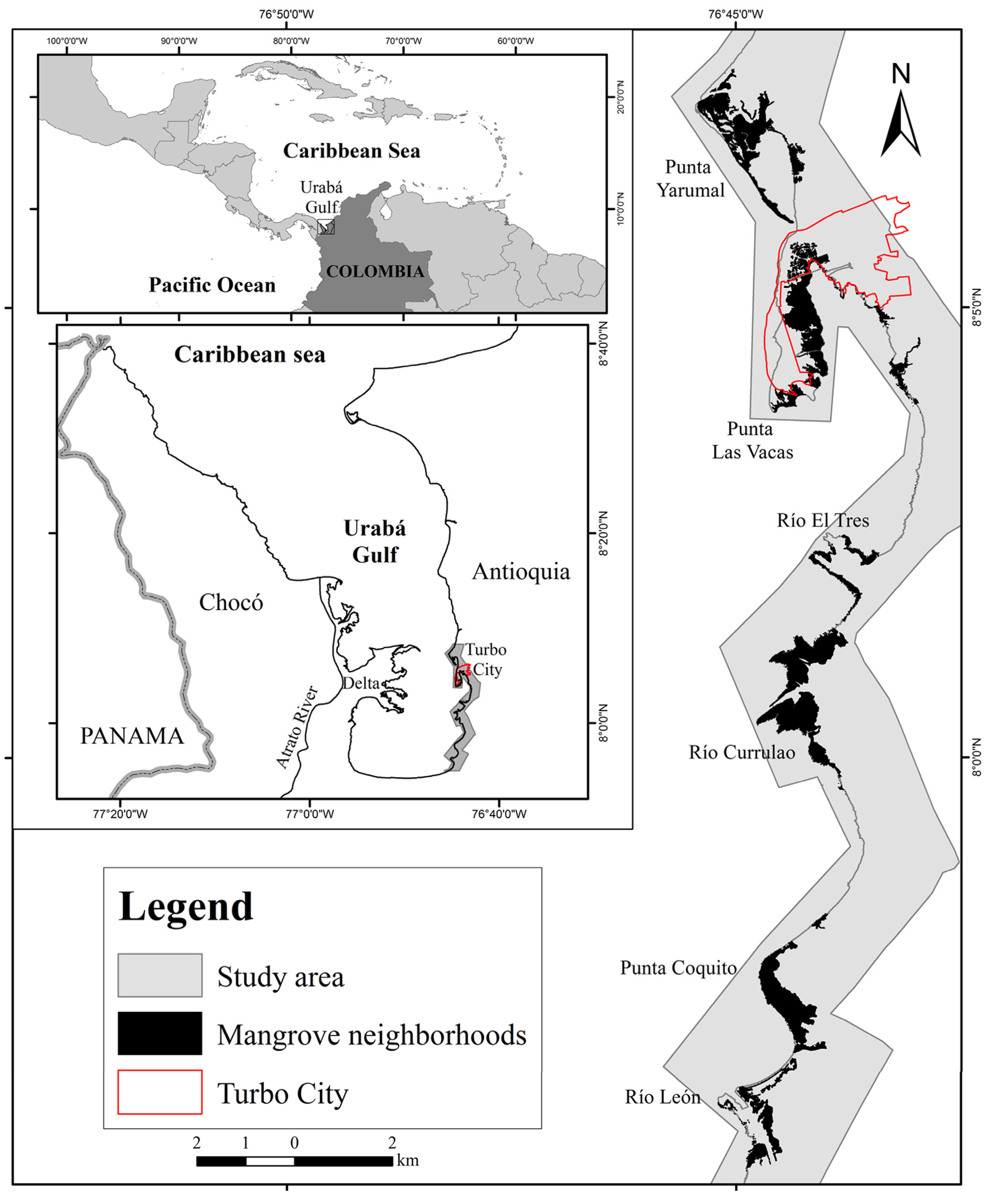
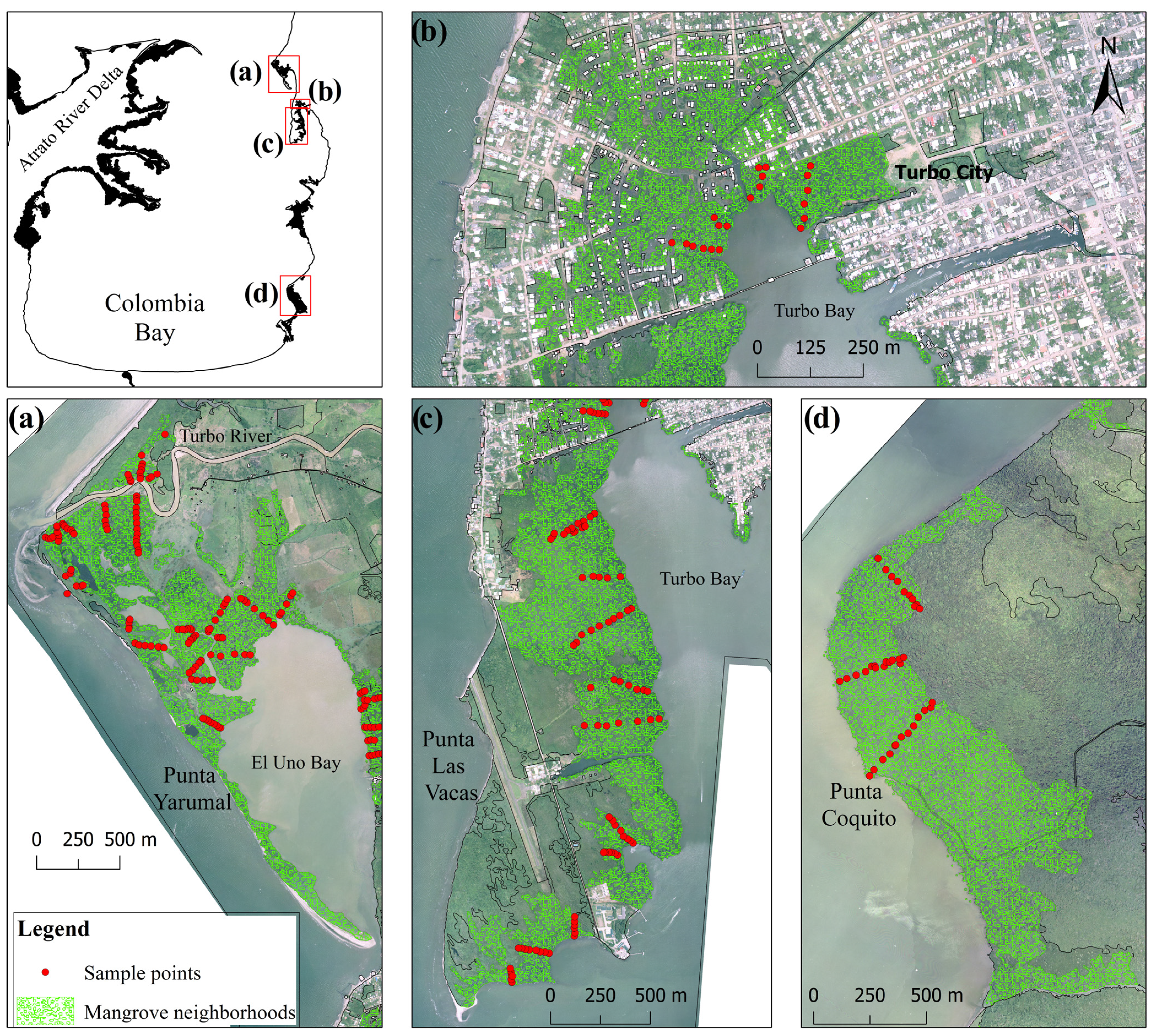
2.1. Study Area

The study was undertaken in three mangrove neighborhoods in Turbo Municipality (Punta Yarumal, Punta Las Vacas and Punta Coquito), located along the Southeast coast of the Urabá Gulf (Antioquia State), Southern Caribbean of Colombia (Figure 1). These mangrove neighborhoods are smaller in area in comparison to those located on the Atrato River Delta (West coast), which comprise 78% of total mangrove extent within the Urabá Gulf. Mangroves along the East coast contain ca.11% of gulf’s total, are highly patchy or fragmented, and are surrounded by anthropogenic land cover such as extensive pastures and banana crops. The Turbo Municipality exhibits the largest population density, mostly concentrated in the urban area (ca. 47,000 inhabitants in 2005; [38]), with the largest along the Urabá Gulf coast and the Southern Caribbean of Colombia [39,40].
The species composition of mangroves in Turbo Municipality is similar to the Greater Caribbean, and particularly the Colombian Caribbean, where Rhizophora mangle, Avicennia germinans, Laguncularia racemosa, Pelliciera rhizophorae and Conocarpus erectus occur, the first two being the most important, forming nearly mono-specific stands in some locations [34,35]. Physiographically, three kinds of mangroves are found: fringing, riverine and basin [35]. Both fringing and basin mangroves tend to be mono-specific, dominated by R. mangle and A. germinans, respectively. In the study area, basin mangroves are more in contact with anthropogenic land covers such as pastures and crops that have reclaimed the former freshwater wetlands. Indeed, forest structure and area show clear signs of human influence in the vicinity of Turbo City [31,32,36,37].
Figure 1. Location of the Southeast coast of the Urabá Gulf (Colombian Caribbean), Turbo Municipality and various mangrove neighborhoods. The urban boundary of Turbo City is shown. The study was conducted in Punta Yarumal, Punta Las Vacas and Punta Coquito.
Diversity 07 00206 g001

2.2. Spatial Data, GIS Methods and Mangrove Change Calculations

High-resolution (0.3 m pixel) and color aerial photographs were taken for the study area in 2009, comprising a coastal fringe nearly 2 km of width containing mangrove neighborhoods. These aerial photos were obtained during the State-government-sponsored research expedition “Antioquia Expedition 2013” [41]. We decided to use the neighborhood concept, defined as a spatial unit grouping mangrove patches found within a well-defined geo-form such as a river delta or a depositional intertidal area [42,43]. This concept is synonymous to Eco-series, defined as a spatial level within the coastal landscape hierarchy comprising land cover and land use areas between 1.5 and 25 ha (sensu [42,43]).
These high-resolution photographs were ortho-rectified and assembled into a single block to depict the current mangrove extent and surrounding land cover. We used the ArcGIS 10.2 software to process the spatial information from this ortho-photo and we mapped 10 different types of land cover: natural types such as mangroves, alluvial forests and shrubs; anthropogenic types such as pasture, crops and built area; and geo-forms such as rivers, waterways, beaches and sea. Therefore, we described the full landscape complexity and either the natural or the anthropogenic domination around the mangroves. We also employed the categories recommended by the national geographic authority (IGAC: Spanish acronym for Agustín Codazzi Geographic Institute) in the spatial object catalog and the CORINE land-cover methodology adapted for Colombia [44,45]. Due to the sub-metric resolution of the 2009-ortho-photo, the minimum mapped area was 0.01 ha and was allowed to discriminate between natural and anthropogenic coverage within small areas. Finally, we validated the photo-interpretation by ground-truthing over seven transects (3.5 km in total) that crossed all types of land cover. The field data was considered the observed data, while the cartographic data were considered the expected data. Observed and expected data for each polygon were contrasted using a confusion matrix to find overall classification accuracy and Kappa coefficients [46,47]. The entire coastal landscape comprised 46.3 km2 (a 79 km coastline).
Further analyzes were conducted only in four contrasting land-use and land-tenure contexts (Figure 2), in agreement with the anthrome classification [3]:
  • Peri-urban: Equivalent to “Dense settlements”, where significant urban area is found. The landscape is a mixture of private and public areas, but “green areas”, “lowlands” and “inter-tidal lands” are public domain.
  • Rural: Equivalent to “Croplands or Rangelands”, where dense agricultural or pastoral land cover are dominant, respectively. The “green elements” of the landscape are a mixture of private and public lands.
  • Military-protected: Equivalent to “Semi-natural”, where forests with minor human presence occur. It is mostly dominated by native tree species, and land-tenure is public.
  • Wild: Equivalent to “Wildlands”, where no land with human populations, agriculture or pastures occur. The land-tenure is public, mostly dominated by coastal freshwater wetlands and mangroves.
These four land use and tenure contexts also differed in terms of the proximity to Turbo City as the largest populated coastal area, and being the wild context, the most remote, and the most isolated. Mangrove extent was computed for 1938 and 2009, under the four contexts, within observation windows of 1 km2 for Rural and Peri-urban, and 2 km2 for Military-protected and Wild contexts. In addition to the 2009 ortho-photo, color or black and white aerial photographs were obtained for each land use context in 1938, 1961, 1975 and 2004. Each photo was geo-referenced relative to the 2009-ortho-photo to compute either gain or loss of mangrove area change according to Puyrabaud’s equation [48].
Figure 2. Location of sampling points on mangrove neighborhoods within four land use and tenure contexts in the Southeast coast of the Urabá Gulf: (a) Rural, (b) Peri-urban, (c) Military, and (d) Wild.
Diversity 07 00206 g002

2.3. Mangrove Neighborhood Fragmentation

To describe the influence of land use context upon mangrove neighborhoods, we measured the length of the mangrove edge in contact with both natural and anthropogenic land cover surrounding each patch [49]. We computed anthropogenic edge (or edge density) as the sum of all percentages of anthropogenic perimeter for all patches. In addition, the degree of fragmentation of each neighborhood was computed as patch density (the ratio between the number of patches and the sum of areas for all patches) [49].

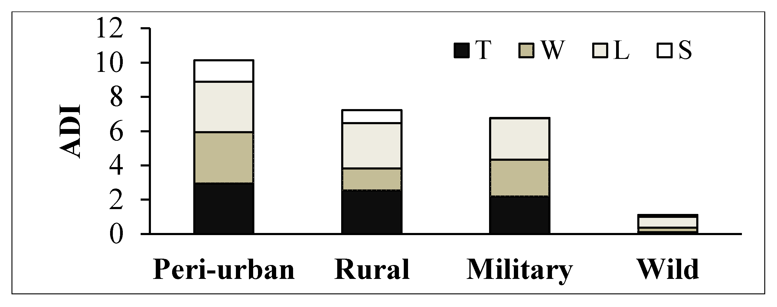
2.4. Mangrove Ecological Condition: Vegetation, Anthropogenic Disturbance Index (ADI) and Dominant Snail Presence

The Point-Centered Quarter Method (PCQM, [50,51]) was employed to describe each patch and neighborhood in terms of species occurrence, diameter at breast height (DBH), density and basal area in 2011. Relative abundance, dominance and frequency were computed to obtain the Importance Value Index (IVI) for each species and transect per land use context. The sampling effort comprised a total of 12 patches, 239 points and 31 transects (oriented perpendicular to the tidal flooding gradient) (Figure 2). The number of patches, points and transects sampled per neighborhood was proportional to the total mangrove area, as follows: 126 points within 14 transects in four rural patches, 17 points within four transects in three peri-urban patches, 70 points within 10 transects in four military-protected patches, and 29 points within three transects in one wild patch.
Associated with the PCQM, we valued the anthropogenic disturbance within each sampling point and patch scoring the degree of influence according to the following categorical variables:
  • Trampling (T): Presence of human and livestock footprints.
  • Logging (L): Evidence of selective logging on mangrove species, such as stumps and downed wood and logs.
  • Wastes (W): Presence of solid wastes on the forest floor and entangled on the roots.
  • Structures (S): Evidence of human modifications of mangrove hydrology and topography (diggings, infillings, cement canals and pipelines), and other structures related to pastoral activities (fences and troughs).
We combined the scores for each categorical variable in an Anthropogenic Disturbance Index (ADI). Each variable was scored from 0 to 3, where 0 means disturbance absence, 1 means little evidence, 2 means evident and 3 means very evident disturbance. Values for each variable were averaged for each land use context and summarized into the ADI as follows:
ADI = T + L + W + S
The ADI ranged from 0 to 12. As a result, transects with values close to 1 exhibited the least anthropogenic disturbance, while those close to 12 exhibited the greatest. The stumps were identified when possible and the DBH measured, to provide further support to the logging component of ADI.
The dominant mangrove snail, Neritina virginea (Prosobranchia: Neritidae), a key component of faunal ecological condition, was selected as the benthic biological indicator of anthropogenic disturbance because it responds negatively on abundance and mean shell size to edge effects [31,32,52]. At each sampling point, we recorded the presence of individuals of this species within a radius of 15 m (Figure 2). With this method, we favored the occurrence of the species over the abundance, and it is therefore conservative and less biased by observer’s skill. Percent presence was computed for each transect.

2.5. Statistical Methods

The deforestation (loss) rates, total and anthropogenic edge length (including total, pasture and urban), total number of patches, patch density, total area and mean patch area, were altogether considered as estimates of mangrove fragmentation for each context. ADI and mean stump DBH for R. mangle were considered as estimates of human access to each transect within each context. Tree density, mean DBH, and IVI per species, and percent presence of gastropods were considered as indicators of ecological condition of each transect within each context.
A Non-Metric Multidimensional Scaling (NMDS) [53] was employed to extract the most important variables correlated with the anthrome classification. Because no replication was possible at the context level, only a single value was available for the 10 patch-based variables included in Table 1 and Table 2 (e.g., deforestation rate and total mangrove area). Mean values of transects per context were employed for ecological condition variables measured using the PCQ method. A total of 22 variables were included in the ordination matrix. No significant difference in the ordination pattern was observed when values for each transect per context were included in the ordination, but the stress was improved. The NMDS was run using the vegan package in R [54]. Data were square-root transformed and a Wisconsin double standardization was employed. After extracting the most important variables defining the anthrome context, variables were correlated using non-parametric (Spearman Rank) or parametric (Pearson) correlations depending on the adjustment to normality, homocedasticity, and sample size of the variables [53]. ADI Table and ecological condition variables were considered as responses of mangrove fragmentation descriptors. All regression analyses were run in Minitab® v.16.

3. Results and Discussion

3.1. Deforestation Rates

The overall classification accuracy was 90.1% and the Kappa coefficient was 0.86 thus indicating that the cartographic products for the entire study landscape analyzed in 2009-ortho-photo were highly reliable. However, mangrove cover was fully distinctive from other covers and hence classification error was zero. Mangrove change rates depended on the context during the period 1938–2009 (Figure 3, Table 1). Loss rate was highest in the Peri-urban context (1.2%·year−1) and lowest in Military and Wild contexts (<1%·year−1). Mangrove net gain was only observed in the Rural context. In this context, despite of the net gain, mangroves have been historically converted to pastures as the deltaic fan has expanded due to increased sedimentation. Mangroves colonized the waterfront over the past six decades due to the relocation of the Turbo River mouth to the North of the city [36]. In the Peri-urban context, mangroves were slowly converted to pastures during the first four decades, but mangroves and pastures have been rapidly converted to marginal human settlements since the late seventies (thus mangroves cleared at ca. 2%·year1, data not shown). In the Military context, coastal geomorphology was nearly steady, but mangroves were replaced by pastures during the first four decades with the establishment of the facility, and the trend has continued. In the Wild context, mangroves have been lost mostly due to coastline retreat, although interior mangroves were lost due to the expansion of banana croplands.
Figure 3. Mangrove-extent change between 1938 and 2009 in (a) Rural, (b) Peri-urban, (c) Military and (d) Wild contexts. Polygon models are shown.
Diversity 07 00206 g003
Table 1. Mangrove area dynamics relative to context between 1938 and 2009. The annual rate of change (r) was calculated according to [48].
ContextArea 1938 (km2)Area 2009 (km2)r (%·year−1)
Rural0.150.250.8
Peri-urban0.550.24−1.2
Military1.010.77−0.4
Wild1.180.66−0.8
The observed deforestation rates in the Peri-urban context exceeded the global average, while the observed rates in Military and Wild contexts were lower [23,55]. Cumulative deforestation rate in Peri-urban mangroves in Turbo City was similar to other Peri-urban sites reported in the literature, considered as hotspots (e.g., Kenya: [18,56,57]). In addition, this figure exceeded that for many of the 10 countries with the largest and best-monitored mangrove areas [23]. Globally, Singapore, both a country and a city, has experienced the largest deforestation rates due to the rapid urbanization process [22,23]. In rural areas, particularly in Southeast Asia and Ecuador, mangroves have been rapidly converted to shrimp aquaculture ponds [58,59]. Conversion to croplands other than rice, coconut and oil palm in Southeast Asia [26,58], and pastures have been less recorded in the literature but seem to be more prevalent in Africa and the Caribbean [55]. Therefore, here we reported a novel transition or regime shift previously unnoticed. Mangrove loss associated with shoreline retreat has been recorded in many locations worldwide [60,61].

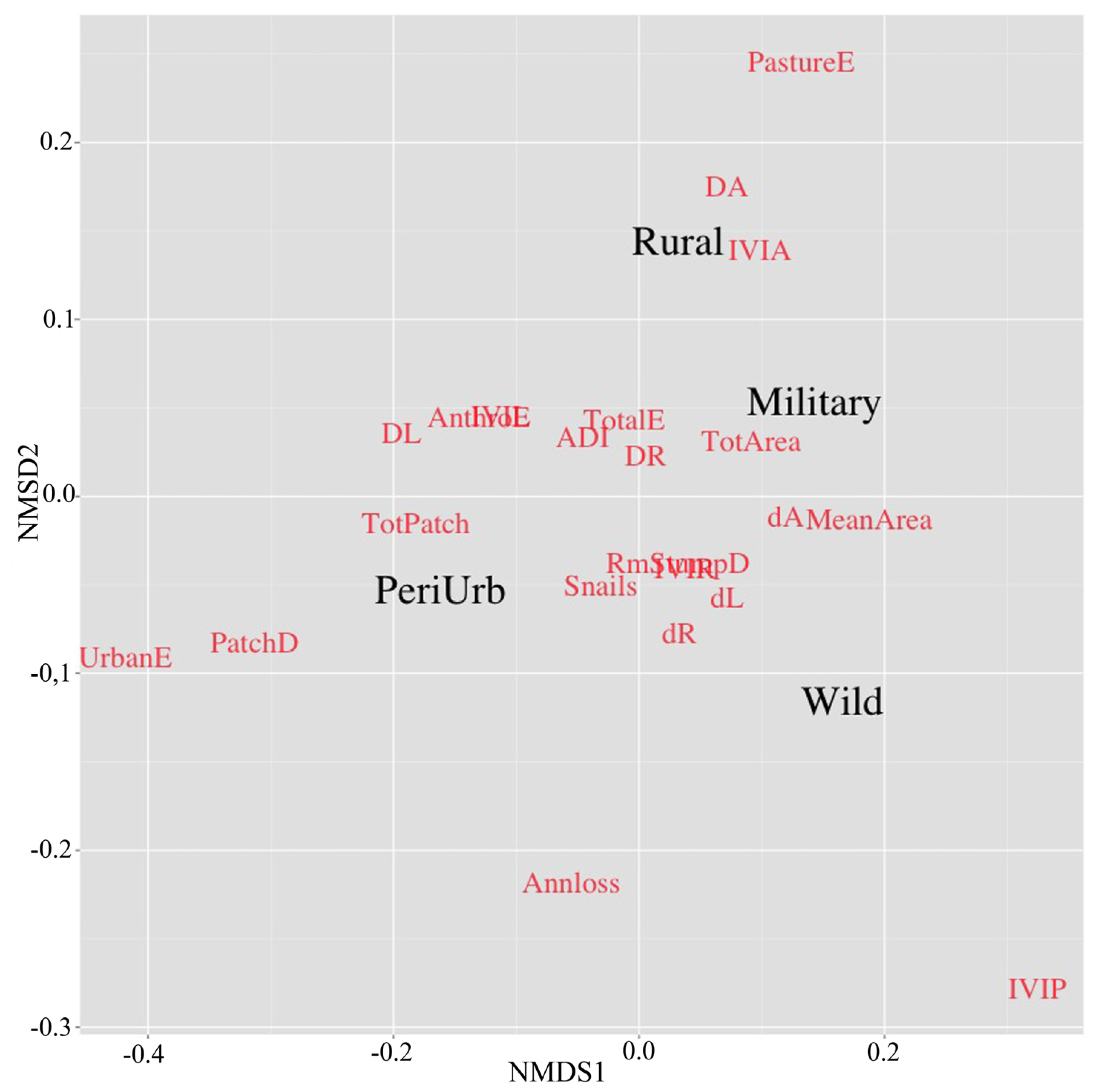
3.2. Mangrove Neighborhood Fragmentation

Anthropogenic edge proportion was significantly larger in the Peri-urban context than in other contexts (Table 2). It was nearly twice that in Rural and Military-protected contexts and >10-fold than that in the Wild context, and it was independent of mean patch area. Patch density was greatest in the Peri-urban context, 10–50 times greater than in other contexts. In the Peri-urban context, the anthropogenic edge was promoted by the construction of wooden houses and other infrastructure, while in the Rural context (to a lesser extent in the others), it was promoted by the establishment of pastures. As a consequence, urban edge length and patch density were the distinctive characteristics of the mangroves in the Peri-urban context, while pasture edge length distinguished those in the Rural context in the NMDS space (Figure 4). Military and Wild contexts exhibited opposite conditions for those characteristics. High total area and mean patch area characterized non Peri-Urban contexts. Annual loss rates of mangroves, however, were not associated with the variables describing neighborhood fragmentation across the study contexts.
Table 2. Patch-based metrics for mangrove neighborhoods within different contexts in the Turbo Municipality in 2009.
VariableContext
Peri-urbanRuralMilitaryWild
Agricultural edge (km)01.600
Urban edge (km)17.00.40.40
Pasture edge (km)09.85.41.0
Total edge (km)20.229.318.614.5
Anthropogenic edge (%)84.340.231.36.6
Total number of patches521555
Patch density (patches/ km2)237.317.04.95.5
Mean patch area (km2)<0.10.10.20.2
Total neighborhood area (km2)0.20.91.00.9
The length of anthropogenic edge was proportional to the size of the anthropogenic matrix or element surrounding the terrestrial vicinity of the mangrove neighborhoods. This pattern has been broadly documented for terrestrial forests [20,21]. The type of the anthropogenic matrix may ease human access to mangroves, as observed in terrestrial forests for the case of hunters and loggers [29,30]. In the Peri-urban context, human access is readily explained by the presence of inhabitants close to mangrove areas, while in the Rural context, pastures have favored human access. Further ecological implications of context will be explained in the following sections. A high edge effect is expected, understood as the ratio between the perimeter to core area, therefore easing human access to the mangrove interior. In terms of the classical definition of ecological edge effect, human access and other influences derived from either the presence of pasture or urban lands venture longer distances under unprotected contexts, or marginally under Military or Wild contexts.
Figure 4. Non-Metric Multi-Dimensional Scaling of mangrove neighborhoods in different contexts in 2011 (Black letters). The ordination was based on 22 variables (Red letters) describing fragmentation (Table 1 and Table 2) and ecological condition (Table 3 and Table 4, in addition to transect-based ADI data pooled in Figure 5 but shown in Figure 6 and Figure 7).
Diversity 07 00206 g004
Codes: Annloss: annual loss rate; UrbanE: urban edge; PastureE: pasture edge; TotalE: total edge; AnthroE: anthropogenic edge; TotPatch: total number of patches; PatchD: patch density; MeanArea: mean patch area; TotArea: total neighborhood area; ADI: Cumulative Anthropogenic Disturbance Index; RmStumpD: Rhizophora mangle stump mean diameter; d: mean tree diameter for R. mangle, L. racemosa and A. germinans; D: mean density for each species; IVI: mean Importance Value Index for each species (including Pelliciera rhizophorae); Snails: mean percent presence for Neritina virginea; Stress: nearly zero when single values for each context were included, due to the reduced number of rows; 0.090 when the 31 individual transect values for ecological condition variables within each context were included. The ordination with the first data set is shown for clarity due to the overlap of many transects within the same context.
High fragmentation and small patch area were observed in Peri-urban and Rural contexts. Therefore, military protection and remoteness seem to reduce mangrove fragmentation, as observed in the literature for terrestrial forests [20,21]. Fragmentation reinforces the ecological edge effects, because the core (center) of small patches can be easily accessed by people and a greater number of small patches could be impacted. Therefore, most of the extent of small patches is subjected to edge effects or cannot be considered as an ecological or functional interior.

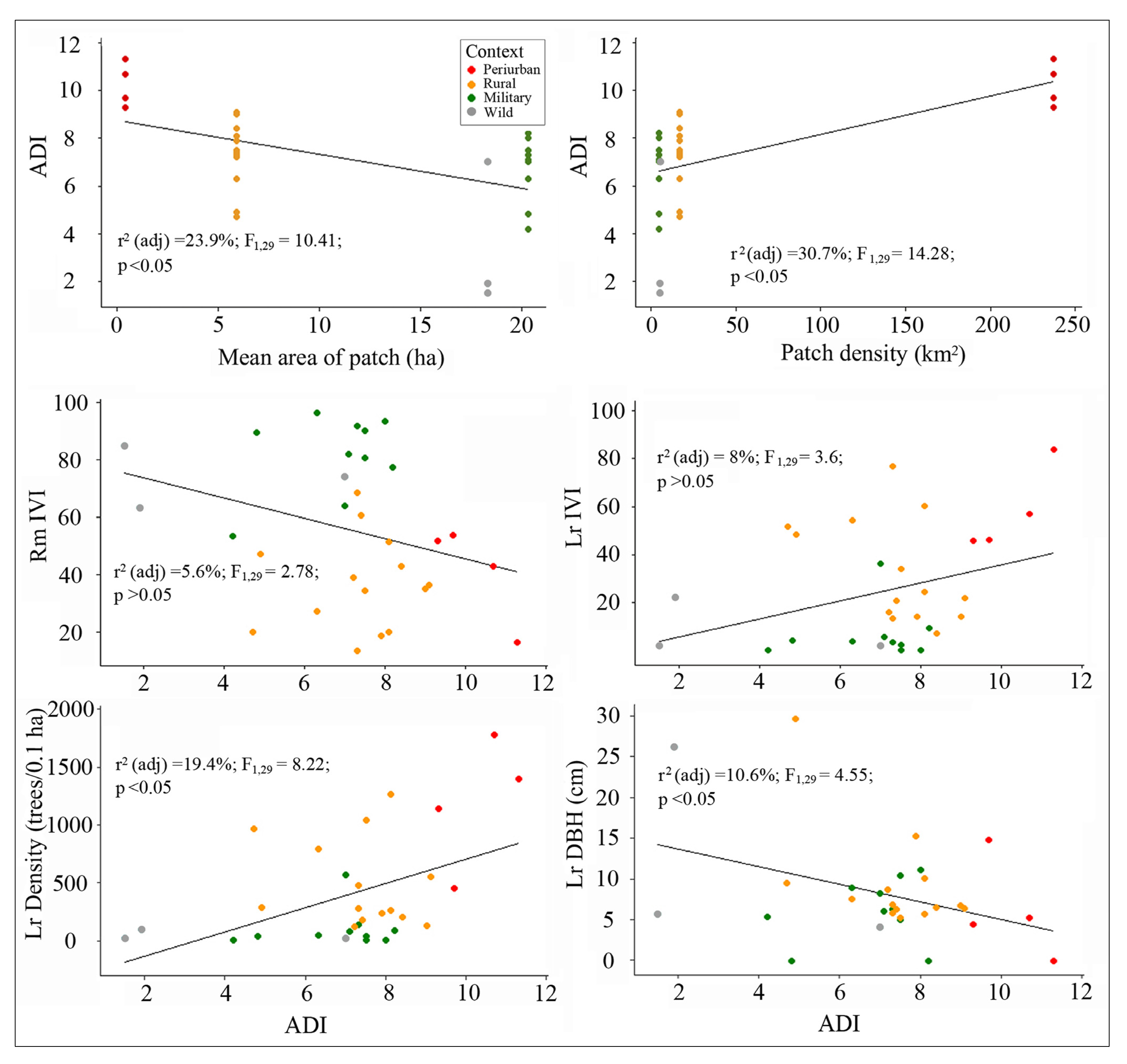
3.3. Fragmentation and Anthropogenic Disturbance Influence on Ecological Condition

3.3.1. ADI Relative to Context

The ADI scores were greater under the Peri-urban context, while they were lower in both Rural and Military-protected contexts, and the lowest in the Wild context (Figure 5). In particular, trampling and logging evidences were greater in Peri-urban and Rural contexts than in the Military and more significantly than in the Wild. This evidence of human access and tree logging were negatively associated with mangrove stump diameter of R. mangle and L. racemosa, the most logged species region-wide (Table 3). Such association was not observed in A. germinans. Human structures such as fences, drainage canals and small cement structures were more frequent in the Rural context. Solid waste did not show a pattern related with land context but with proximity to Turbo City.
Table 3. Number and diameter (mean and range) of stumps in three common mangrove species in mangrove neighborhoods in different contexts in 2011.
SpeciesPeri-urbanRuralMilitaryWild
NumberDiameter (cm)NumberDiameter (cm)NumberDiameter (cm)NumberDiameter (cm)
Rhizophora mangle47.7
(6–9.5)
606.7
(4.1–11.4)
658.5
(5–15.6)
1412.5
(9–23)
Laguncularia racemosa228.6
(6–17.8)
687.5
(5.1–15.6)
1911
(5–20)
0N.A.
Avicennia germinans0N.A.423.0
(6.3–37.2)
39.4
(5.4–14)
147
N.A.: Not available.
Figure 5. Cumulative scores of the Anthropogenic Disturbance Index (ADI) in mangrove neighborhoods in different contexts in 2011.
Diversity 07 00206 g005
T: trampling; L: logging; W: waste; S: human structures. See the dispersion of ADI values across the individual transects in each context in Figure 6 and Figure 7.
Although the ADI seemed to play a secondary role explaining the ordination of the study contexts when the fragmentation descriptors were included (Figure 4), it was significantly correlated with mean patch area (−) and mean patch density (+) (Figure 6). The ADI was greater at Peri-urban and Rural contexts, and therefore seemed to be influenced by anthropogenic edge length, in turn influenced by patch area. It confirms the hypothesis that, as observed in terrestrial forests, surrounding anthropogenic matrices or elements facilitate people access (mostly through land than water) to mangrove areas particularly for logging. Field observations suggest that loggers enter the mangroves from the land to extract firewood, while they access by boat to extract poles, R. mangle and L. racemosa being the target species.

3.3.2. Mangrove Vegetation Relative to ADI

The ADI was a significant predictor of mangrove vegetation structure across the study area as a result of anthrome context (Table 4, Figure 6). Transect-scale density and mean DBH of L. racemosa (white mangrove) showed strong correlations, respectively positive and negative, with ADI. No significant trend was observed for the IVI of both L. racemosa and R. mangle (red mangrove). The NMDS also showed that natural features such as high IVI of P. rhizophorae (piñuelo mangrove) and A. germinans (black mangrove) were distinctive of mangroves in Wild and Rural contexts, respectively (Figure 4). Finally, Peri-Urban mangroves were featured by high densities of L. racemosa, while mangroves across the Rural, Military and Wild gradient exhibited a progressive increase in mean DBH for all species (Figure 4).
Table 4. Mangrove structure variables for neighborhoods in different contexts in 2011. Mean and standard deviation values are shown.
ContextSpeciesDBH (cm) (mean ± s.d.) Density
(trees/0.1 ha)
Basal area (m2/0.1 ha)Frequency
(%)
IVI (%)
Peri-urbanRm11.0 ± 669.7 ± 42.15.3 ± 6.919 ± 535 ± 14
Lr6.0 ± 4.4119.6 ± 563.6 ± 2.179 ± 564 ± 15
Ag3.5 *8.2 *<0.01 *6 *3 *
RuralRm5.5 ± 8.463.8 ± 33.52.9 ± 2.680 ± 1835 ± 13
Lr8.3 ± 8.3 48.6 ± 387.9 ± 12.467 ± 1733 ± 19
Ag16.3 ± 8.135.0 ± 23.58.1 ± 11.855 ± 2432 ± 17
MilitaryRm10.5 ± 6.3 96.2 ± 67.116.7 ± 6.967 ± 1378 ± 13
Lr8.0 ± 6.3 9.9 ± 17.10.7 ± 213 ± 158 ± 12
Ag17.5 ± 6.3 13.3 ± 17.11.3 ± 2.118 ± 1413 ± 13
Pr10.1 ± 6.2 1.4 ± 3.30.03 ± 0.082 ± 41 ± 3
WildRm18.6 ± 16 47.9 ± 21.871.0 ± 6.556 ± 570 ± 10
Lr20.8 ± 19.1 4.4 ± 4.11.4 ± 2.512 ± 109 ± 11
Ag29.5 ± 18.8 3.3 ± 3.10.9 ± 2.59 ± 127 ± 9
Pr11.9 ± 17.9 12.8 ± 11.11.8 ± 2.423 ± 2014 ± 12
DBH: Diameter at Breast Height; IVI: Importance Value Index; Rm: R. mangle; Lr: L. racemosa; Ag: A. germinans; Pr: Pelliciera rhizophorae. Note the presence of the latter species only in Military and Wild contexts. The IVI was expressed as the percent of the maximum potential number (300), based on the maximum values of relative density, dominance and frequency. See number of replicates (sampling points and transects) in text.*: A deviation was not computed because a single tree was found.
Figure 6. Pearson’s correlation and linear regression parameters between mangrove fragmentation variables, ADI and vegetation structure parameters in mangrove neighborhoods in Turbo Municipality in 2011. Regressions of ADI relative to mean patch area and density, and of R. mangle IVI, and IVI, density and DBH of L. racemosa relative to ADI are shown.
Diversity 07 00206 g006
Anthropogenic disturbance, as a result of anthrome-dependent fragmentation, was a strong driver of mangrove structure in Turbo Municipality. L. racemosa may be employed as the indicator species of logging influence and overharvesting upon R. mangle, which tended to exhibit a reduced IVI in Peri-urban and Rural contexts. Poor ecological condition in mangrove vegetation has been observed in Peri-urban locations worldwide, being the finest examples recorded in Kenya [18]. In a previous paper [36], we reported the region-wide negative correlation between the IVI of L. racemosa and R. mangle, and hypothesized that such a species transition was the result of overlogging on the latter. Here, we demonstrate that the degree of selective logging across an urban-to-wild gradient is the mechanism explaining such transition.
The poor ecological conditions observed in mangroves patches surrounded by Peri-urban and Rural contexts could be detrimental not only at a local scale but also for mangroves located near the military-protected area. For instance, Kairo et al. [62] found that mangrove volume and extent adjacent to Kaiunga MPA in Kenya were important for providing regeneration opportunities inside the reserve and sustainable exploitation off the boundaries. Therefore, mangroves within the military-protected area near Turbo City might become progressively ecologically isolated if overlogging and fragmentation continue in unprotected mangroves.
The presence of P. rhizophorae, a vulnerable species according to the International Union for the Conservation of Nature [31,63], in both Military and Wild contexts highlight the importance of law enforcement and geographical isolation, respectively, for preserving imperiled species. This finding is consistent with the high densities of Endangered Species Act-listed taxa and imperiled species in military lands in Hawaiian terrestrial forests [15].
Finally, our results provide the first indicators of mangrove vegetation features under the anthrome classification [3,4]. Mangroves in Peri-urban and Rural contexts in our study area may be classified as used ecosystems dominated by L. racemosa, an otherwise secondary species elsewhere in the Urabá Gulf [34,35]. Unfortunately, mangroves in the Wild context showed some evidence of anthropogenic influence, particularly at the landscape level (e.g., area loss and proximity to banana crops within <5 km inland and likely access by boat from Turbo City); therefore, it best fits the definition of a remote biome rather than a wild one.

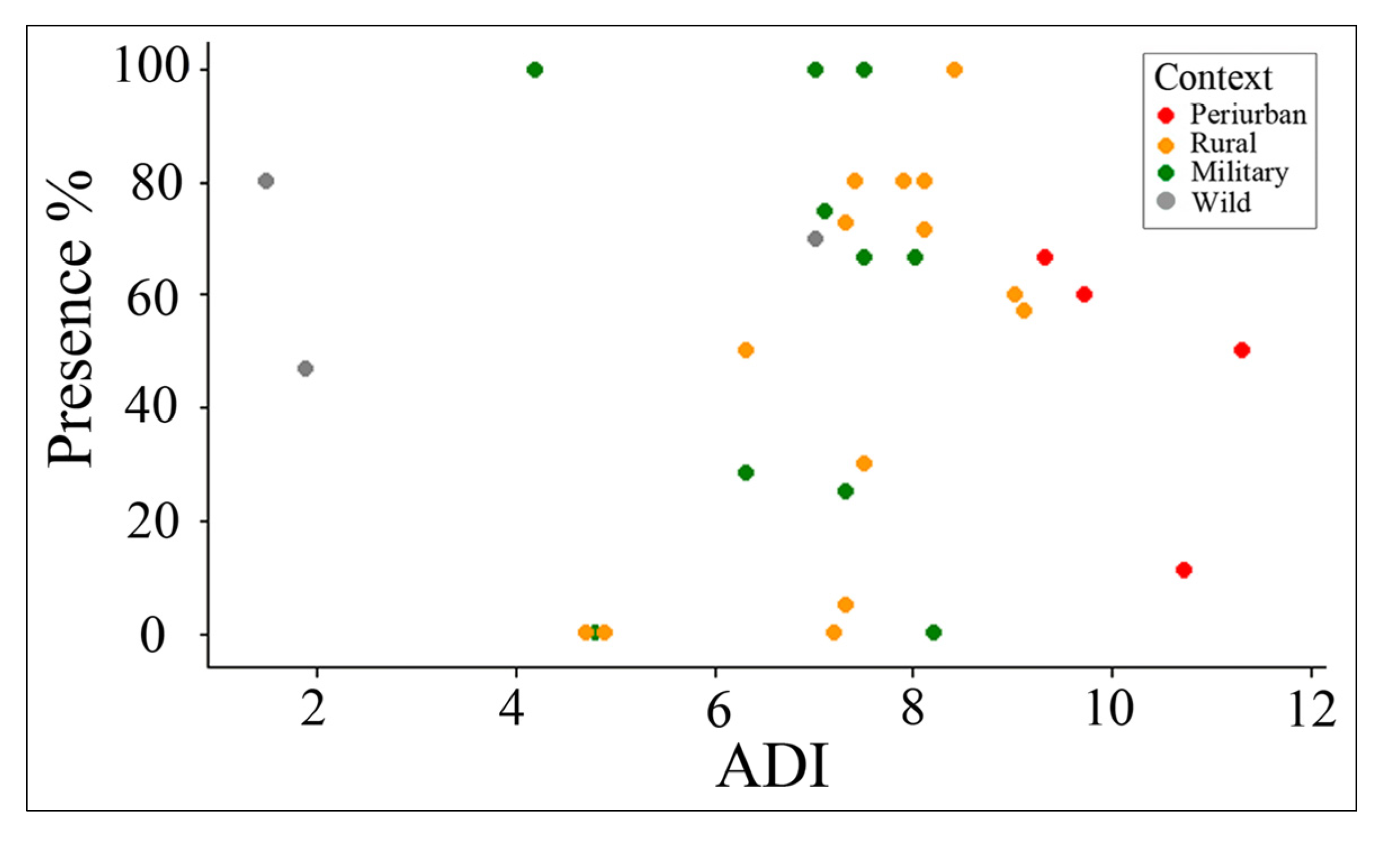
3.3.3. Snail Presence Relative to ADI

The snail presence showed no correlation with the ADI, because it was highly variable across transects, even within the same context (Figure 7). Moreover, high percentages of presence were equally recorded in all contexts, despite the lowest values being recorded outside the Wild context. This result was inconsistent with our previous findings in the rural mangroves to the North of Turbo City where snail frequency linearly declined from the mangrove interior to the adjacent pastures, and it was lower in heavily logged mangrove interiors [34]. Therefore, an edge effect upon snail frequency was inconsistent with the land use and tenure categories analyzed in the present study. A closer analysis suggested that snail frequency was greater in the Peri-urban mangroves because deforestation did not contribute to mangrove desiccation and, on the contrary, the houses are built on pilings to avoid flooding, and hence the intertidal habitat seemed little affected. Most of the human occupation on Peri-urban areas took place in fringing mangroves. Therefore, the present study indicates that edge effects are seemingly restricted to the interior-pasture ecotone rather than to the mangrove fringe. Therefore, an analysis of within-patch patterns should be the objective of future research. In addition, a greater effect on logging has been reported on the tree-climbing pulmonate gastropod Melampus coffeus in black mangrove inner zones adjacent to pastures in the vicinity of Turbo [31,32]. Regardless of our results, we recommend testing for edge effects on ground-dwelling and tree-climbing snail populations and the ecosystem processes that they control in Caribbean and African mangroves, where gastropod species such as Melampus coffeus and Terebraliapalustris, respectively, contribute large biomasses to the benthic consumer-level [64,65]. In addition, we recommend testing for edge effects on ground-dwelling crabs, as we recently reported an edge effect on the population of a vulnerable mangrove blue crab (Gecarcinidae: Cardisoma guanhumi) in the same rural mangroves in the vicinity of Turbo City [37]. Bioturbation by gecarcinid and grapsid crabs is an important ecosystem process well documented in many mangroves world-wide and it can be impacted by both natural and anthropogenic disturbances [66].
Figure 7. Neritina virginea presence in mangrove neighborhoods in different contexts in Turbo Municipality
Diversity 07 00206 g007

4. Conclusions and Perspectives

This study concluded that, although different mangrove change rates (1938–2009) were observed in different land-tenure contexts, they were inconsistent with the present-day patterns of mangrove neighborhood fragmentation. However, Peri-urban mangroves were distinctively fragmented as demonstrated by long edges and high density of patches, Rural mangroves were characterized by long edges surrounded by pastures, and both protected and wild mangroves were dominated by large patches. The main effect of fragmentation in Peri-urban and Rural mangroves was the high density of an otherwise secondary species, the white mangrove L. racemosa, promoted by logging upon red mangrove trees. No effect was found on a dominant benthic gastropod. These findings provide lessons for mangrove management as follows. Firstly, surveillance was important for preserving mangrove landscape integrity and, consequently, forest physiognomy in public lands. This is justified because human access to mangroves for logging was eased by the presence of pastures and built areas in the vicinity, and it was the main driver of a poor ecological condition (thin diameter trees) in unprotected land-tenure contexts in Turbo Municipality. Therefore, the main lesson from our study is the requirement of law enforcement (even through co-management) to prevent conversion of mangroves and surrounding freshwater wetlands to pastures and other land covers outside the limits of protected areas and conservation targets. This action would reduce access for illegal logging and extraction of non-woody products, particularly in the proximity to major human settlements. Secondly, this study demonstrated that isolation from major urban centers, by itself, provides a foundation for mangrove conservation. Mangroves in remote and wild locations should be a priority for legal conservation actions such as MPA declaration, particularly where vulnerable fauna and flora are found, such as the piñuelo mangrove (P. rhizophorae) in our case. Thirdly, and equally important, this study demonstrates that mangroves in rural (unprotected) settings may still contain valuable features that are worthy of conservation efforts. These features are the following: (a) the presence of large trees of the black mangrove (A. germinans), a species of localized distribution, indicator of the seasonally dry conditions in the Eastern coast of the Urabá Gulf, and scant in the wetter West Coast, (b) the dominance of the white mangrove (L. racemosa), offsetting the overlogging upon the red mangrove (R. mangle), therefore proving resiliency to the ecosystem, and (c) the habitat of the blue crab that sustains an important folk catchery.
At a global scale, it is urgent to conduct regional and national assessments of mangrove ecological condition. Since we observed that fragmentation (increased edge length and decreased patch area) is an important driver of human access and mangrove ecological condition, we hypothesize that cumulative small-scale edge effects might scale up to whole patches and neighborhoods, and, ultimately, to the entire regions, as proposed for terrestrial forests [67]. We recommend a thorough field assessment of understory ecological conditions and targets for conservation in coastal-scapes, where remote sensors allow identifying sharp mangrove-to-pasture edges. It is an action of utmost importance in the Caribbean region where mangroves have been encroached upon by cattle ranching or urban expansion over various decades.
As a final remark, bearing in mind that the expansion of rangelands, villages and dense settlements are a major sign of the Anthropocene, this process and the resulting spatial mosaics offer a new paradigm for studying and preserving the biosphere, and therefore imposing new responsibilities, both conceptually and methodologically [10]. A change in the mindset of managers and conservation biologists is needed to accept that urban and rural landscapes, and areas outside MPAs, in general, are new scenarios for the conservation, that may harbor fairly high species richness that provide valuable ecosystem services [5,9]. As the new responsibility is to sustain biodiversity and people at the same time [7], conservation ecologists need to move from studying only pristine areas and MPAs (sensu [68]), in our case, to learning scientific lessons and finding conservation opportunities for mangroves in anthropogenic coastal-scapes.

Acknowledgments

This research was funded by The Urabá Gulf Expedition, an Antioquia State-funded initiative (Antioquia Expedition Program) led by Universidad de Antioquia. The 1938 aerial photograph was kindly provided by Iván Correa from the Geology Department, Universidad EAFIT, as part of this expedition. Two additional small grants from Universidad de Antioquia’s Research Committee (Regional Programs) funded further field-work: “Deforestation in Urabá Gulf East coast mangroves” and “Distribution of populations of the piñuelo mangrove in Urabá Gulf”. Fieldwork was supported by undergraduate students from the “Coastal Zone Ecology Program” based in the Marine Science Campus in Turbo. Thanks are due to Sara R. López-Rodríguez for advice to run the analyses in R. Thanks are due to the two anonymous reviewers for the comments that greatly improved the manuscript. Writing was supported by “Estrategia de Sostenibilidad 2014–2015”. ELICE Contribution No. 21.

Author Contributions

Juan F. Blanco-Libreros conceived and designed the research, conducted data analyses, and wrote the paper. Edgar A. Estrada-Urrea conducted fieldwork, supported data analyses, and contributed to paper writing. This paper reports partial results of Edgar A. Estrada-Urrea master’s thesis.

Conflicts of Interest

The authors declare no conflict of interest.

References

  1. Malhi, Y.; Gardner, T.A.; Goldsmith, G.R.; Silman, M.R.; Zelazowski, P. Tropical forests in the Anthropocene. Ann. Rev. Environ. Resour. 2014, 39, 125–159. [Google Scholar] [CrossRef]
  2. Lugo, A.E.; Medina, E.; McGinley, K. Issues and challenges of mangrove conservation in the Anthropocene. Madera y Bosques 2014, 20, 11–38. [Google Scholar]
  3. Ellis, E.C.; Ramankutty, N. Putting people in the map: Anthropogenic biomes of the world. Front. Ecol. Environ. 2008, 6, 439–447. [Google Scholar] [CrossRef]
  4. Ellis, E.C. Anthropogenic transformation of the terrestrial biosphere. Philos. Trans. R. Soc. Math. Phys. Eng. Sci. 2011, 369, 1010–1035. [Google Scholar] [CrossRef] [PubMed]
  5. Ellis, E.C.; Antill, E.C.; Kreft, H. All Is Not Loss: Plant Biodiversity in the Anthropocene. PLoS ONE 2012, 7, e30535. [Google Scholar] [CrossRef] [PubMed]
  6. DeFries, R.S.; Ellis, E.C.; Chapin, F.S.; Matson, P.A.; Turner, B.L.; Agrawal, A.; Crutzen, P.J.; Peter, C.F.; Kareiva, P.M.; Lambin, E.; et al. Planetary opportunities: A social contract for global change science to contribute to a sustainable future. BioScience 2012, 62, 603–606. [Google Scholar]
  7. Ellis, E.C. Sustaining biodiversity and people in the world’s anthropogenic biomes. Curr. Opin. Environ. Sustain. 2013, 5, 368–372. [Google Scholar] [CrossRef]
  8. Hobbs, R.J.; Higgs, E.; Hall, C.M.; Bridgewater, P.; Chapin, F.S., III; Ellis, E.C.; Ewel, J.J.; Hallett, L.M.; Harris, J.; Hulvey, K.B.; et al. Managing the whole landscape: Historical, hybrid, and novel ecosystems. Front. Ecol. Environ. 2014, 12, 557–564. [Google Scholar] [CrossRef] [Green Version]
  9. Martin, L.J.; Quinn, J.E.; Ellis, E.C.; Shaw, M.R.; Dorning, M.A.; Hallett, L.M.; Heller, N.E.; Hobbs, R.J.; Kraft, C.E.; Law, E.; et al. Conservation opportunities across the world’s anthromes. Divers. Distrib. 2014, 20, 745–755. [Google Scholar] [CrossRef]
  10. Ellis, E.C.; Haff, P.K. Earth science in the Anthropocene: New epoch, new paradigm, new responsibilities. Eos, Trans. Am. Geophys. Union 2009, 90, 473. [Google Scholar] [CrossRef]
  11. Macintosh, D.J.; Ashton, E.C.; Havanon, S. Mangrove rehabilitation and intertidal biodiversity: A study in the Ranong mangrove ecosystem, Thailand. Estuar. Coast. Shelf Sci. 2002, 55, 331–345. [Google Scholar] [CrossRef]
  12. Primavera, J.H.; Esteban, J.M.A. A review of mangrove rehabilitation in the Philippines: Successes, failures and future prospects. Wetl. Ecol. Manag. 2008, 16, 345–358. [Google Scholar] [CrossRef]
  13. Ellison, A.M.; Farnsworth, E.J. Anthropogenic disturbance of Caribbean mangrove ecosystems: Past impacts, present trends, and future predictions. Biotropica 1996, 28, 549–565. [Google Scholar] [CrossRef]
  14. Laurance, W.F.; Useche, D.C.; Rendeiro, J.; Kalka, M.; Bradshaw, C.J.A.; Sloan, S.P.; Laurance, S.G.; Campbell, M.; Abernethy, K.; Alvarez, P.; et al. Averting biodiversity collapse in tropical forest protected areas. Nature 2012, 489, 290–294. [Google Scholar] [CrossRef] [PubMed]
  15. Stein, B.A.; Scott, C.; Benton, N. Federal lands and endangered species: The role of military and other federal lands in sustaining biodiversity. Bioscience 2008, 58, 339–347. [Google Scholar] [CrossRef]
  16. Cohn, J.P. New defenders of wildlife. BioScience 1996, 46, 1–14. [Google Scholar] [CrossRef]
  17. Castilla, J.C. Roles of experimental marine ecology in coastal management and conservation. J. Exp. Mar. Biol. Ecol. 2000, 250, 3–21. [Google Scholar] [CrossRef]
  18. Bosire, J.O.; Kaino, J.J.; Olagoke, A.O.; Mwihaki, L.M.; Ogendi, G.M.; Kairo, J.G.; Berger, U.; Macharia, D. Mangroves in peril: Unprecedented degradation rates of peri-urban mangroves in Kenya. Biogeosciences Discuss 2013, 10, 16371–16404. [Google Scholar] [CrossRef]
  19. Martinuzzi, S.; Gould, W.A.; Lugo, A.E.; Medina, E. Conversion and recovery of Puerto Rican mangroves: 200 years of change. For. Ecol. Manag. 2009, 257, 75–84. [Google Scholar] [CrossRef]
  20. Fahrig, L. Effects of habitat fragmentation on biodiversity. Ann. Rev. Ecol. Evol. Syst. 2003, 34, 487–515. [Google Scholar] [CrossRef]
  21. Ries, L.; Fletcher, R.J., Jr.; Battin, J.; Sisk, T.D. Ecological responses to habitat edges: Mechanisms, models, and variability explained. Ann. Rev. Ecol. Evol. Syst. 2004, 35, 491–522. [Google Scholar] [CrossRef]
  22. Friess, D.A.; Phelps, J.; Leong, R.C.; Lee, W.K.; Wee, A.K.S.; Sivasothi, N.; Oh, R.R.Y.; Webb, E.L. Mandai mangrove, Singapore: Lessons for the conservation of Southeast Asia’s mangroves. Raffles Bull. Zool. 2012, 25, 55–65. [Google Scholar]
  23. Friess, D.A.; Webb, E.L. Variability in mangrove change estimates and implications for the assessment of ecosystem service provision. Glob. Ecol. Biogeogr. 2014, 23, 715–725. [Google Scholar] [CrossRef]
  24. Sanchez-Azofeifa, G.A.; Daily, G.C.; Pfaff, A.S.P.; Busch, C. Integrity and isolation of Costa Rica’s national parks and biological reserves: Examining the dynamics of land-cover change. Biol. Conserv. 2003, 109, 123–135. [Google Scholar] [CrossRef]
  25. Kuenzer, C.; Bluemel, A.; Gebhardt, S.; Tuan Vo, Q.; Dech, S. Remote sensing of mangrove ecosystems: A review. Remote Sens. 2011, 3, 878–928. [Google Scholar] [CrossRef]
  26. Giri, C.; Ochieng, E.; Tieszen, L.L.; Zhu, Z.; Singh, A.; Loveland, T.; Masek, J.; Duke, N. Status and distribution of mangrove forests of the world using earth observation satellite data. Glob. Ecol. Biogeogr. 2011, 20, 154–159. [Google Scholar] [CrossRef]
  27. Skilleter, G.A. Validation of rapid assessment of damage in urban mangrove forests and relationships with molluscan assemblages. J. Mar. Biol. Assoc. UK. 1996, 76, 701–716. [Google Scholar] [CrossRef]
  28. McDonnell, M.J.; Pickett, S.T.A. Ecosystem structure and function along urban rural gradients: An unexploited opportunity for ecology. Ecology. 1990, 71, 1232–1237. [Google Scholar] [CrossRef]
  29. Laurance, W.F.; Lovejoy, T.E.; Vasconcelos, H.L.; Bruna, E.M.; Didham, R.K.; Stouffer, P.C.; Gascon, C.; Bierregaard, R.O.; Laurance, S.G.; Sampaio, E. Ecosystem decay of Amazonian forest fragments: A 22-year investigation. Conserv. Biol. 2002, 16, 605–618. [Google Scholar] [CrossRef]
  30. Laurance, W.F.; Camargo, J.L.C.; Luizao, R.C.C.; Laurance, S.G.; Pimm, S.L.; Bruna, E.M.; Stouffer, P.C.; Williamson, G.B.; Benitez-Malvido, J.; Vasconcelos, H.L.; et al. The fate of Amazonian forest fragments: A 32-year investigation. Biol. Conserv. 2011, 144, 56–67. [Google Scholar] [CrossRef]
  31. Blanco, J.F.; Castaño, M.C. Effects mangrove conversion to pasture on density and shell size of two gastropods in the turbo river delta (Urabá Gulf, Caribbean Coast of Colombia). Rev. Biol. Trop. 2012, 60, 1707–1719. [Google Scholar] [PubMed]
  32. Amortegui-Torres, V.; Taborda-Marín, A.; Blanco, J.F. Edge effect on a Neritina virginea (Neritimorpha, Neritinidae) population in a black mangrove stand (Magnoliopsida, Avicenniaceae: Avicennia germinans) in the Southern Caribbean. Pan-Am. J. Aquat. Sci. 2013, 8, 68–78. [Google Scholar]
  33. Satyanarayana, B.; Mulder, S.; Jayatissa, L.P.; Dahdouh-Guebas, F. Are the mangroves in the Galle-Unawatuna area (Sri Lanka) at risk? A social-ecological approach involving local stakeholders for a better conservation policy. Ocean Coast. Manag. 2013, 71, 225–237. [Google Scholar] [CrossRef]
  34. Blanco, J.F.; Estrada, E.A.; Ortiz, L.F.; Urrego, L.E. Ecosystem-wide impacts of deforestation in mangroves: The Urabá Gulf (Colombian Caribbean) case study. ISRN Ecol. 2012, 2012, 1–14. [Google Scholar] [CrossRef]
  35. Urrego, L.E.; Molina, E.C.; Suárez, J.A. Environmental and anthropogenic influences on the distribution, structure, and floristic composition of mangrove forests of the Gulf of Urabá (Colombian Caribbean). Aquat. Bot. 2014, 114, 42–49. [Google Scholar] [CrossRef]
  36. Blanco, J.F.; Taborda-Marín, A.; Amortegui-Torres, V.; Arroyave-Rincón, A.; Sandoval, A.; Estrada, E.A.; Leal-Flórez, J.; Vásquez-Arango, J.G.; Vivas-Narváez, A. Deforestation and sedimentation in Uraba Gulf mangroves. A synthesis of the impacts on macrobenthos and fishes in the Turbo River Delta. Rev. Gest. Ambient. 2013, 16, 19–36. [Google Scholar]
  37. Arroyave-Rincón, A.; Amortegui-Torres, V.; Blanco-Libreros, J.F.; Taborda-Marín, A. Edge effect on a blue crab population Cardisoma guanhumi (Decapoda: Gecarcinidae) in the mangrove of El Uno Bay, Urabá Gulf (Colombia): An approximation to the folk catchery. Actual. Biol. (Medellín) 2014, 36, 47–57. [Google Scholar]
  38. Colombia, D.A.N.E. General Census 2005, Population Conciliated. Available online: https://www.dane.gov.co/index.php/poblacion-y-demografia/sistema-de-consulta (accessed on 30 January 2015).
  39. CORPOURABA (Corporación para el Desarrollo Sostenible de Urabá). Caracterización y zonificación de los manglares del Golfo de Urabá Departamento de Antioquia. Proyecto Zonificación y Ordenamiento de los manglares de Urabá; Convenio 201671 FONADE-CORPOURABA; Documento técnico; CORPOURABA: Apartadó, Colombia, 2003. (In Spanish) [Google Scholar]
  40. CORPOURABA. Plan de manejo integral de los manglares del golfo de Urabá y mar Caribe antioqueño; Corporación para el Desarrollo Sostenible de Urabá CORPOURABA; Documento técnico; CORPOURABA: Apartadó, Colombia, 2005. (In Spanish) [Google Scholar]
  41. Blanco, J.F.; Londoño-Mesa, M.; Quan-Young, L.; Urrego, L.; Polanía, J.; Osorio, A.; Bernal, G.; Correa, I. The Urabá Gulf mangrove expedition of Colombia. ISME/GLOMIS 2011, 9, 8–10. [Google Scholar]
  42. Klijn, F.; Dehaes, H.A.U. A hierarchical approach to ecosystems and its implications for ecological land classification. Landsc. Ecol. 1994, 9, 89–104. [Google Scholar] [CrossRef]
  43. Dahdouh-Guebas, F.; Triest, L.; Verneirt, M. The importance of a hierarchical ecosystem classification for the biological evaluation and selection of least valuable sites. Impact Assess. Proj. Apprais. 1998, 16, 185–194. [Google Scholar] [CrossRef]
  44. Colombia Instituto de Hidrología, Meteorología y Estudios Ambientales (IDEAM). Leyenda Nacional de Coberturas de la Tierra. Metodología CORINE LandCover adaptada para Colombia Escala 1:100.000; Editorial Scripto Ltda IDEAM: Bogotá, D.C., Colombia, 2010; p. 72. (In Spanish) [Google Scholar]
  45. Melo-Wilches, L.H.; Camacho-Chávez, M.A. Interpretación visual de imágenes de sensores remotos y su aplicación en levantamientos de cobertura y uso de la Tierra; Instituto Geográfico Agustín Codazzi IGAC: Bogota, D.C., Colombia, 2005. (In Spanish) [Google Scholar]
  46. Congalton, R.G. A review of assessing the accuracy of classifications of remotely sensed data. Remote Sens. Environ. 1991, 37, 35–46. [Google Scholar] [CrossRef]
  47. Foody, G.M. Status of land cover classification accuracy assessment. Remote Sens. Environ. 2002, 80, 185–201. [Google Scholar] [CrossRef]
  48. Puyravaud, J.P. Standardizing the calculation of the annual rate of deforestation. For. Ecol. Manag. 2003, 177, 593–596. [Google Scholar] [CrossRef]
  49. Hargis, C.D.; Bissonette, J.A.; David, J.L. The behavior of landscape metrics commonly used in the study of habitat fragmentation. Landsc. Ecol. 1998, 13, 167–186. [Google Scholar] [CrossRef]
  50. Cintrón, G.; Schaeffer-Novelli, Y. Methods for studying mangrove structure. In The Mangrove Ecosystem: Research Methods. Monographs on Oceanographic Methodology, No. 8; Snedaker, S.C., Snedaker, J.G., Eds.; United Nations Educational, Scientific and Cultural Organization Publisher, Richard Clay (The Chaucer Press), UNESCO: Paris, France, 1985; pp. 91–113. [Google Scholar]
  51. Dahdouh-Guebas, F.; Koedam, N. Empirical estimate of the reliability of the use of the Point-Centred Quarter Method (PCQM): Solutions to ambiguous field situations and description of the PCQM+ protocol. For. Ecol. Manag. 2006, 228, 1–18. [Google Scholar] [CrossRef]
  52. Ortiz, L.F.; Blanco, J.F. Distribution of the mangrove gastropods Neritina virginea (Neritidae) and Littoraria angulifera (Littorinidae) within the Colombian Caribbean, Darién Ecoregion. Rev. Biol. Trop. 2012, 60, 219–232. [Google Scholar]
  53. R Development Core Team. R: A Language and Environment for Statistical Computing; R Foundation for Statistical Computing: Vienna, Austria, 2008; Available online: http//www.R-project.org (accessed on 29 May 2015).
  54. Gotelli, N.J.; Ellison, A.M. A Primer of Ecological Statistics; Sinauer Associates, Inc.: Sunderland, MA, USA, 2004; p. 510. [Google Scholar]
  55. FAO. The World’s Mangroves 1980–2005; FAO Forestry Paper 153; Food and Agricultural: Rome, Italy, 2007; p. 77. [Google Scholar]
  56. Kirui, K.B.; Kairo, J.G.; Bosire, J.; Viergever, K.M.; Rudra, S.; Huxham, M.; Briers, R.A. Mapping of mangrove forest land cover change along the Kenya coastline using Landsat imagery. Ocean Coast. Manag. 2013, 83, 19–24. [Google Scholar] [CrossRef]
  57. Rideout, A.J.R.; Joshi, N.P.; Viergever, K.M.; Huxham, M.; Briers, R.A. Making predictions of mangrove deforestation: A comparison of two methods in Kenya. Glob. Chang. Biol. 2013, 19, 3493–3501. [Google Scholar] [CrossRef]
  58. Thu, P.M.; Populus, J. Status and changes of mangrove forest in Mekong delta: Case study in Tra Vinh, Vietnam. Estuar. Coast. Shelf Sci. 2007, 71, 98–109. [Google Scholar] [CrossRef]
  59. Hamilton, S. Assessing the role of commercial aquaculture in displacing mangrove forest. Bull. Mar. Sci. 2013, 89, 585–601. [Google Scholar] [CrossRef]
  60. Webb, E.L.; Friess, D.A.; Krauss, K.W.; Cahoon, D.R.; Guntenspergen, G.R.; Phelps, J. A global standard for monitoring coastal wetland vulnerability to accelerated sea-level rise. Nat. Clim. Chang. 2013, 3, 458–465. [Google Scholar] [CrossRef]
  61. Gilman, E.L.; Ellison, J.; Duke, N.C.; Field, C. Threats to mangroves from climate change and adaptation options: A review. Aquat. Bot. 2008, 89, 237–250. [Google Scholar] [CrossRef]
  62. Kairo, J.G.; Kivyatu, B.; Koedam, N. Application of remote sensing and GIS in the management of mangrove forests within and adjacent to Kiunga Marine Protected Area, Lamu, Kenya. Environ. Dev. Sustain. 2002, 4, 153–166. [Google Scholar] [CrossRef]
  63. Polidoro, B.A.; Carpenter, K.E.; Collins, L.; Duke, N.C.; Ellison, A.M.; Ellison, J.C.; Farnsworth, E.J.; Fernando, E.S.; Kathiresan, K.; Koedam, N.E.; et al. The loss of species: Mangrove extinction risk and geographic areas of global concern. PLoS ONE 2010. [Google Scholar] [CrossRef]
  64. Cannicci, S.; Burrows, D.; Fratini, S.; Smith, T.J., III; Offenberg, J.; Dahdouh-Guebas, F. Faunal impact on vegetation structure and ecosystem function in mangrove forests: A review. Aquat. Bot. 2008, 89, 186–200. [Google Scholar] [CrossRef]
  65. Lee, S.Y. Mangrove macrobenthos: Assemblages, services, and linkages. J. Sea Res. 2008, 59, 16–29. [Google Scholar] [CrossRef]
  66. Diele, K.; Ngoc, D.M.T.; Geist, S.J.; Meyer, F.W.; Pham, Q.H.; Saint-Paul, U.; Tran, T.; Berger, U. Impact of typhoon disturbance on the diversity of key ecosystem engineers in a monoculture mangrove forest plantation, Can Gio Biosphere Reserve, Vietnam. Glob. Planet. Chang. 2013, 110, 236–248. [Google Scholar] [CrossRef]
  67. Laurance, W.F. Do edge effects occur over large spatial scales? Trends Ecol. Evol. 2000, 15, 134–135. [Google Scholar] [CrossRef]
  68. Martin, L.J.; Blossey, B.; Ellis, E. Mapping where ecologists work: Biases in the global distribution of terrestrial ecological observations. Front. Ecol. Environ. 2012, 10, 195–201. [Google Scholar] [CrossRef]

