Measuring Spatial Patterns of Health Care Facilities and Their Relationships with Hypertension Inpatients in a Network-Constrained Urban System

Abstract
:1. Introduction
2. Materials and Methods
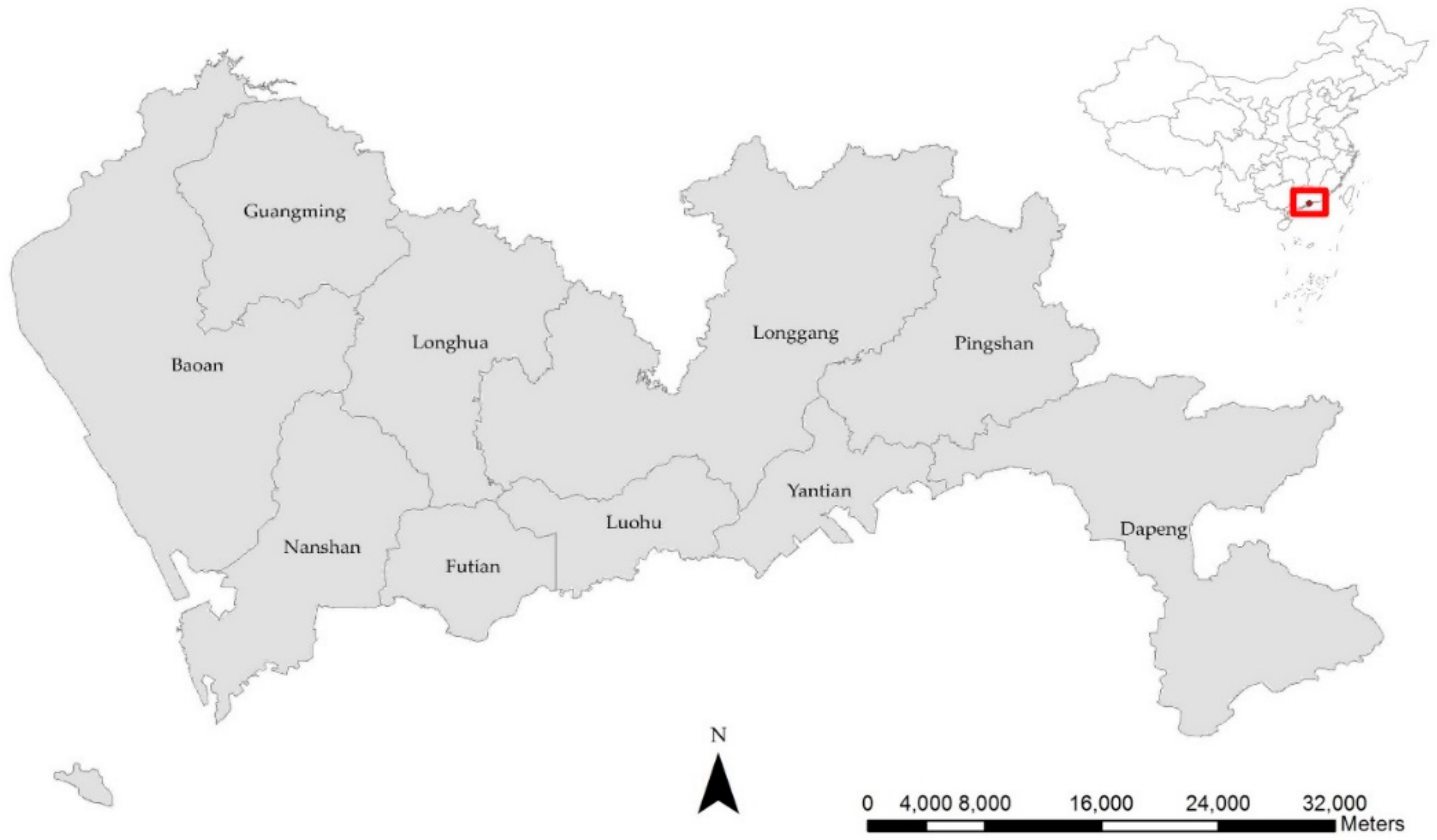
2.1. Study Area
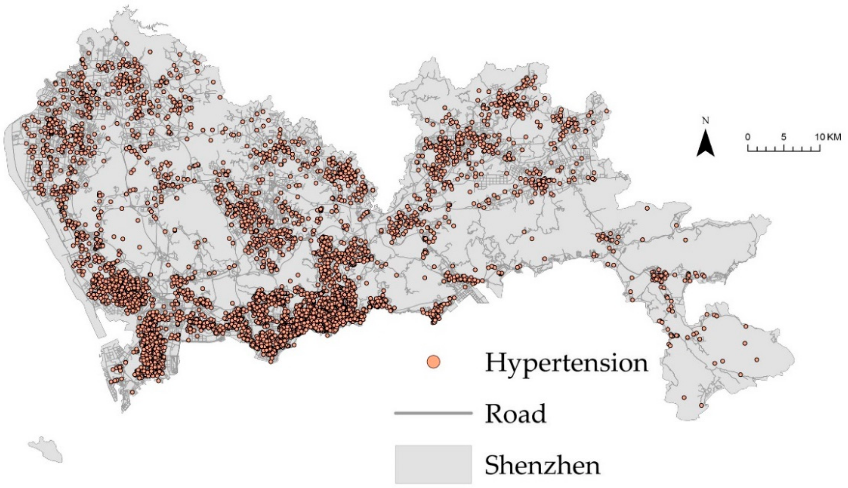
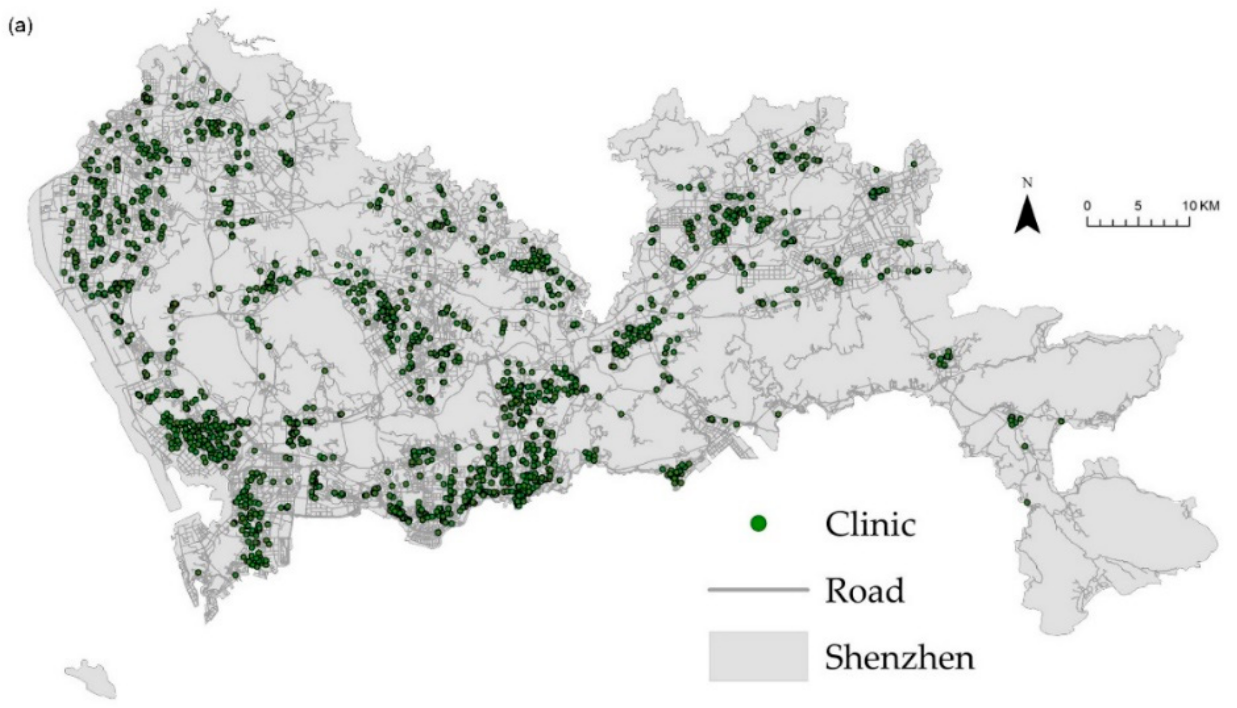
2.2. Data Sources
2.3. Network Kernel Density Estimation
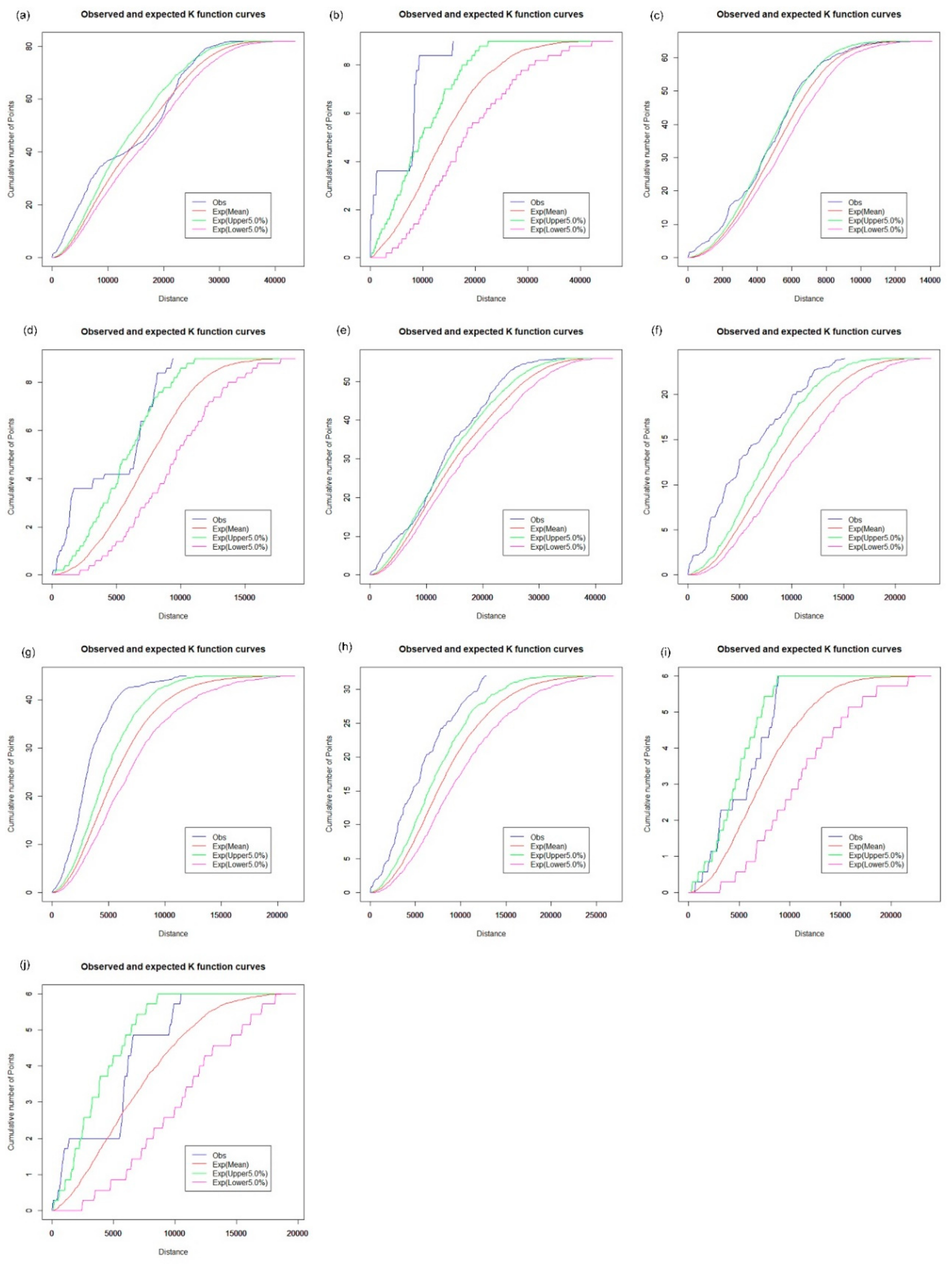
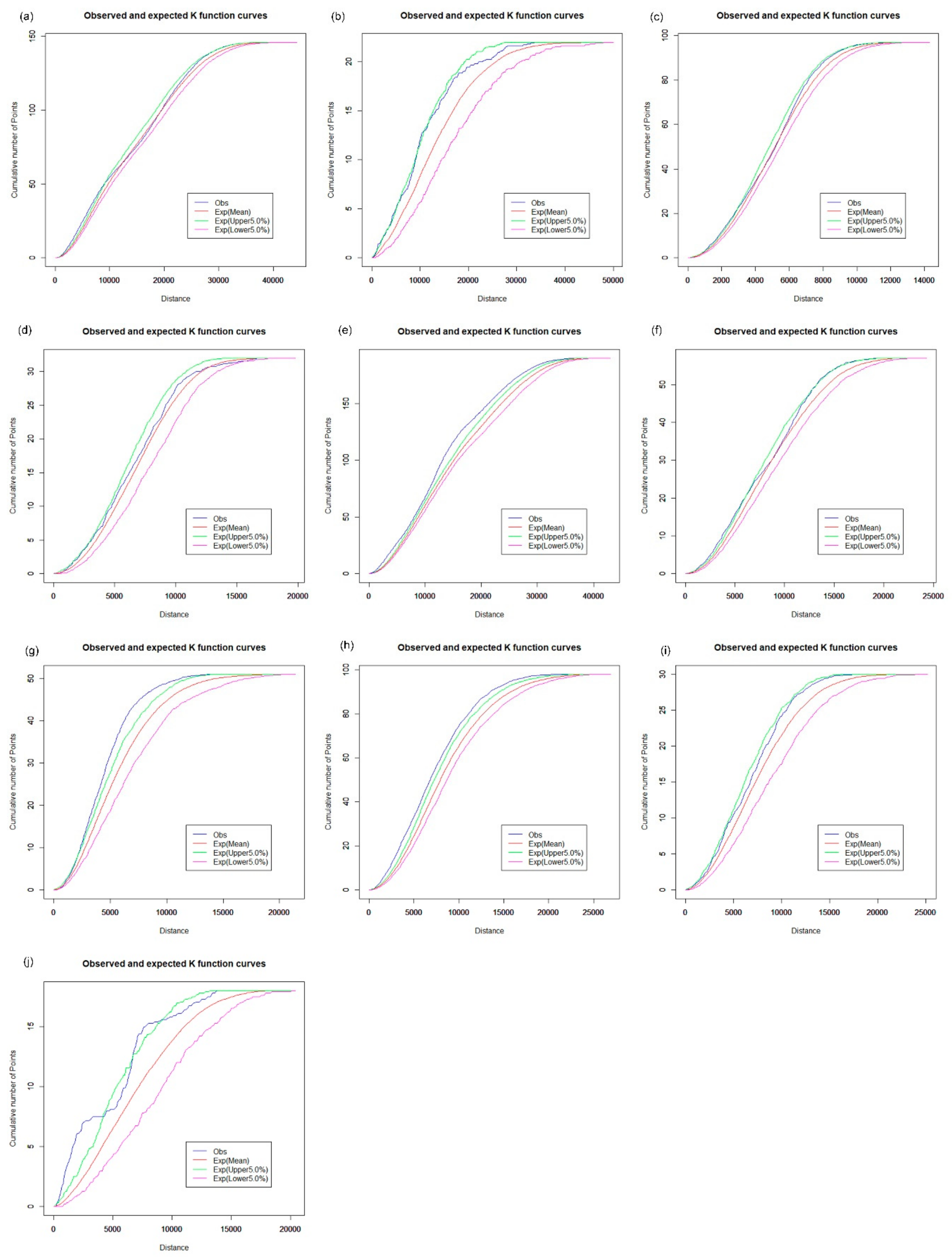
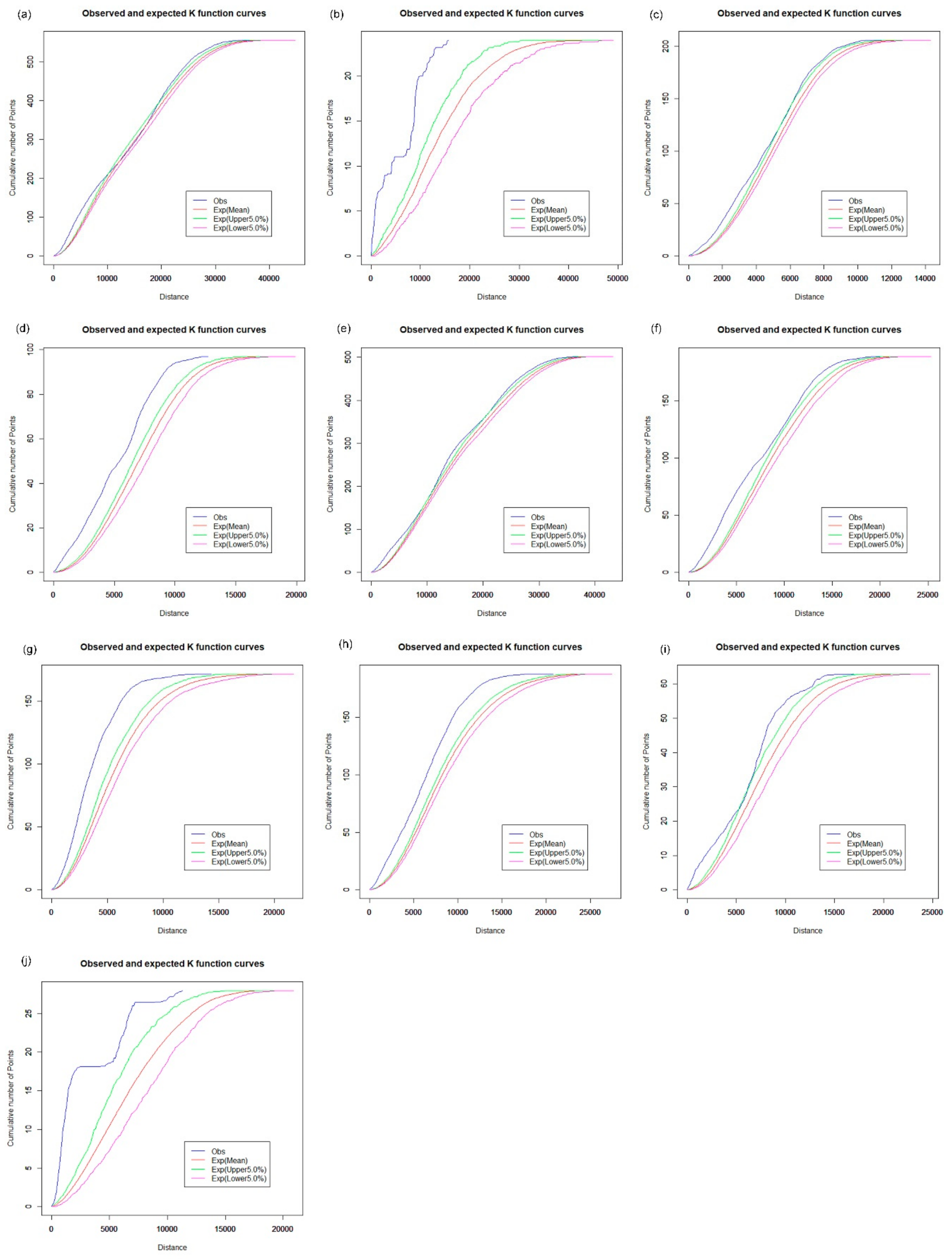
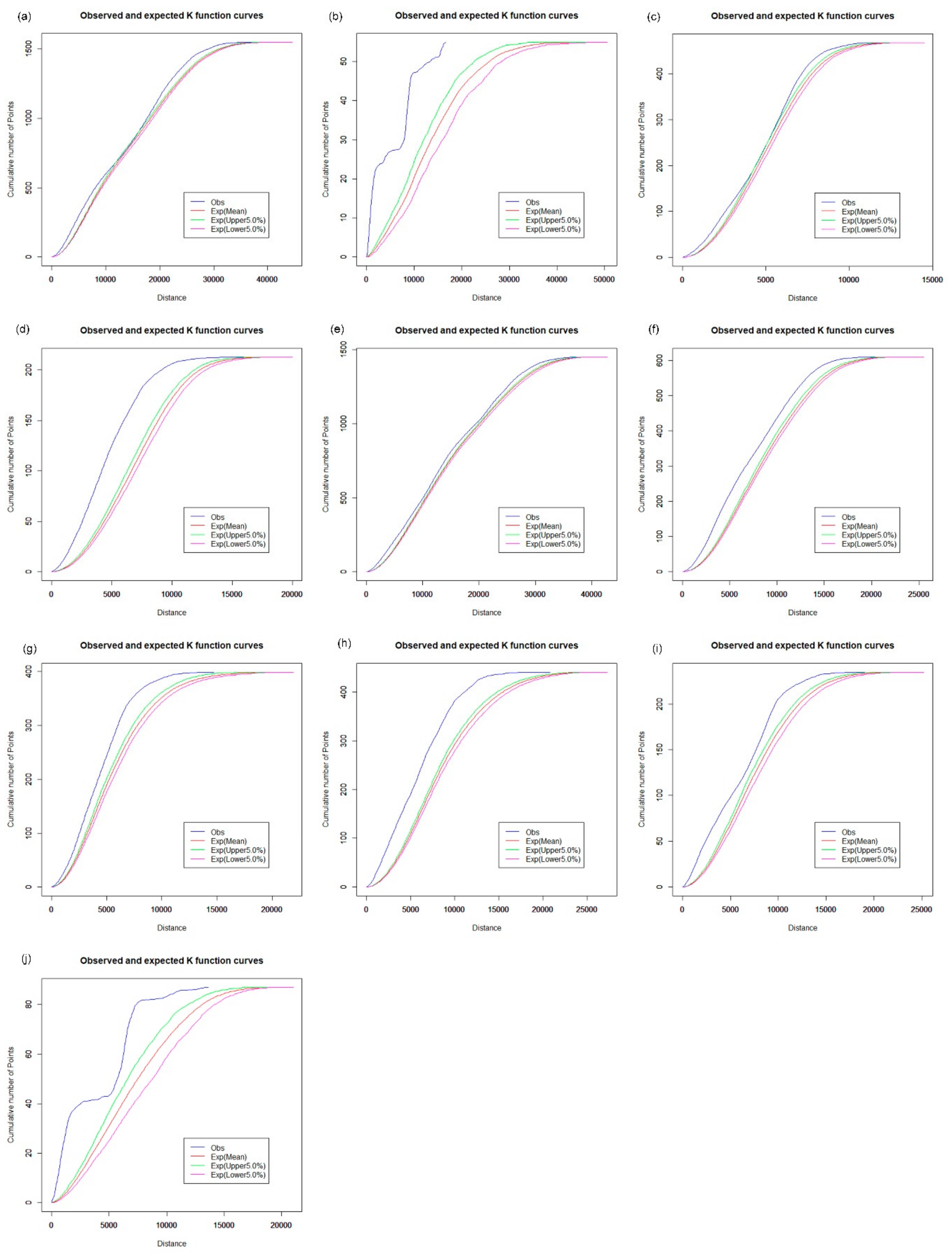
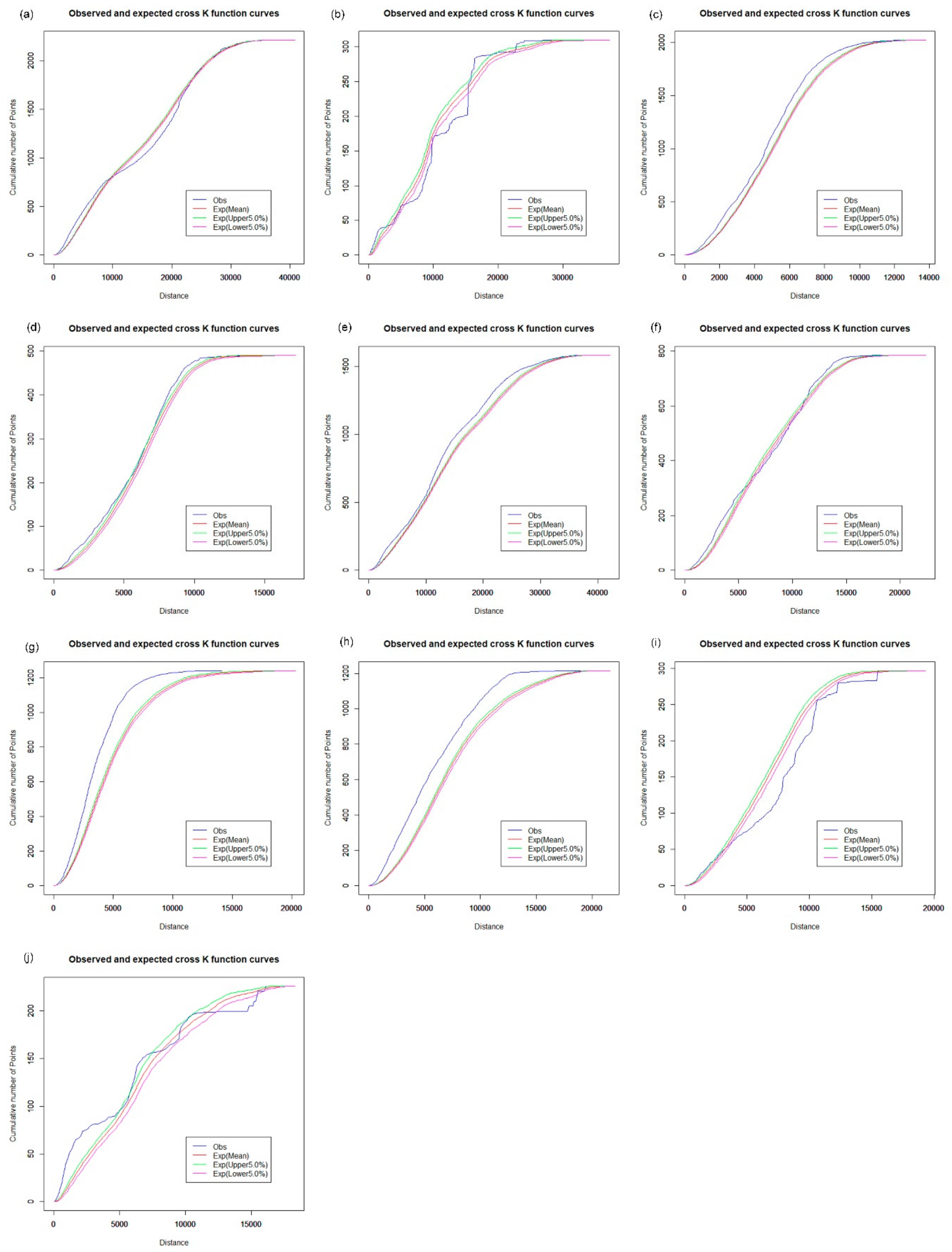
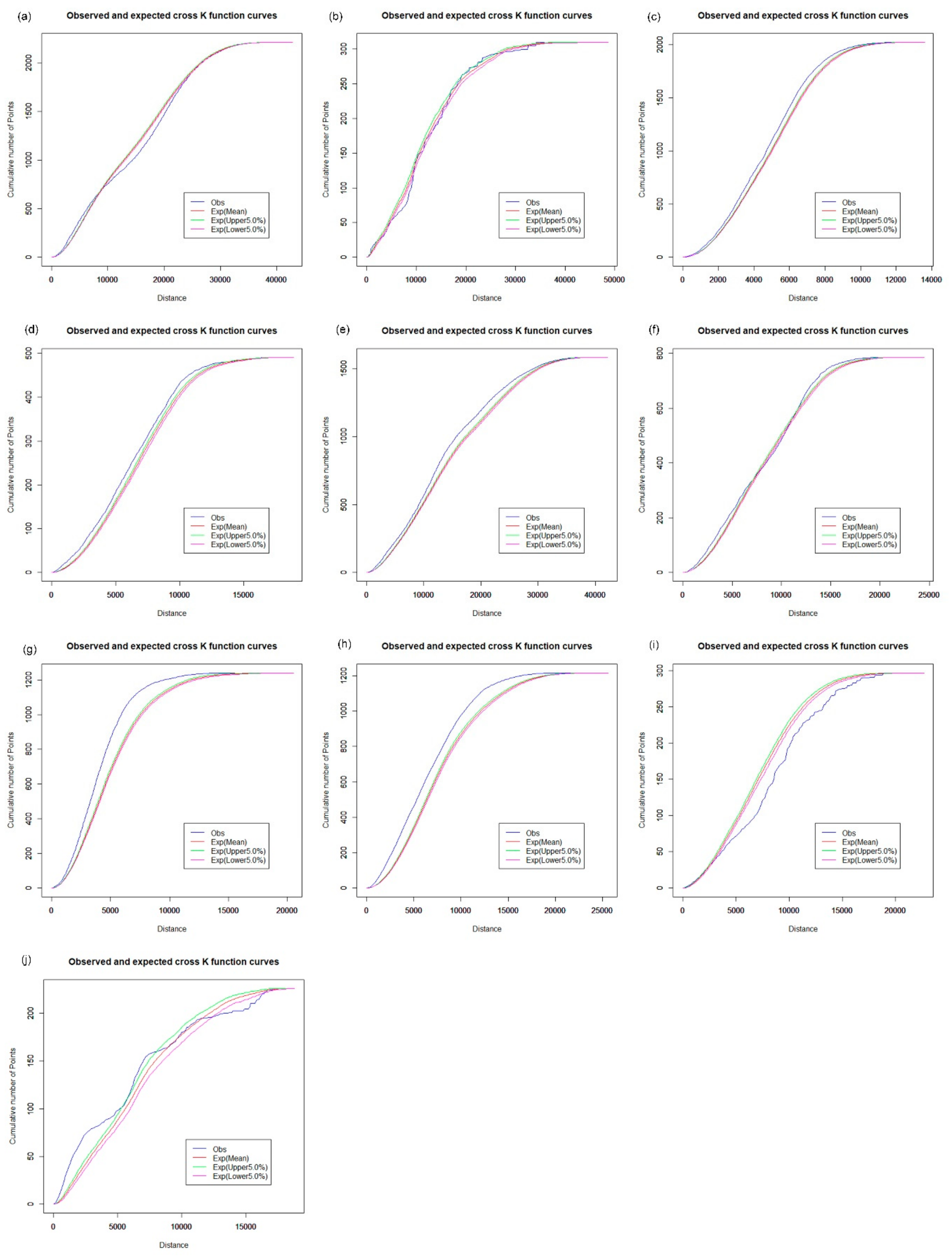
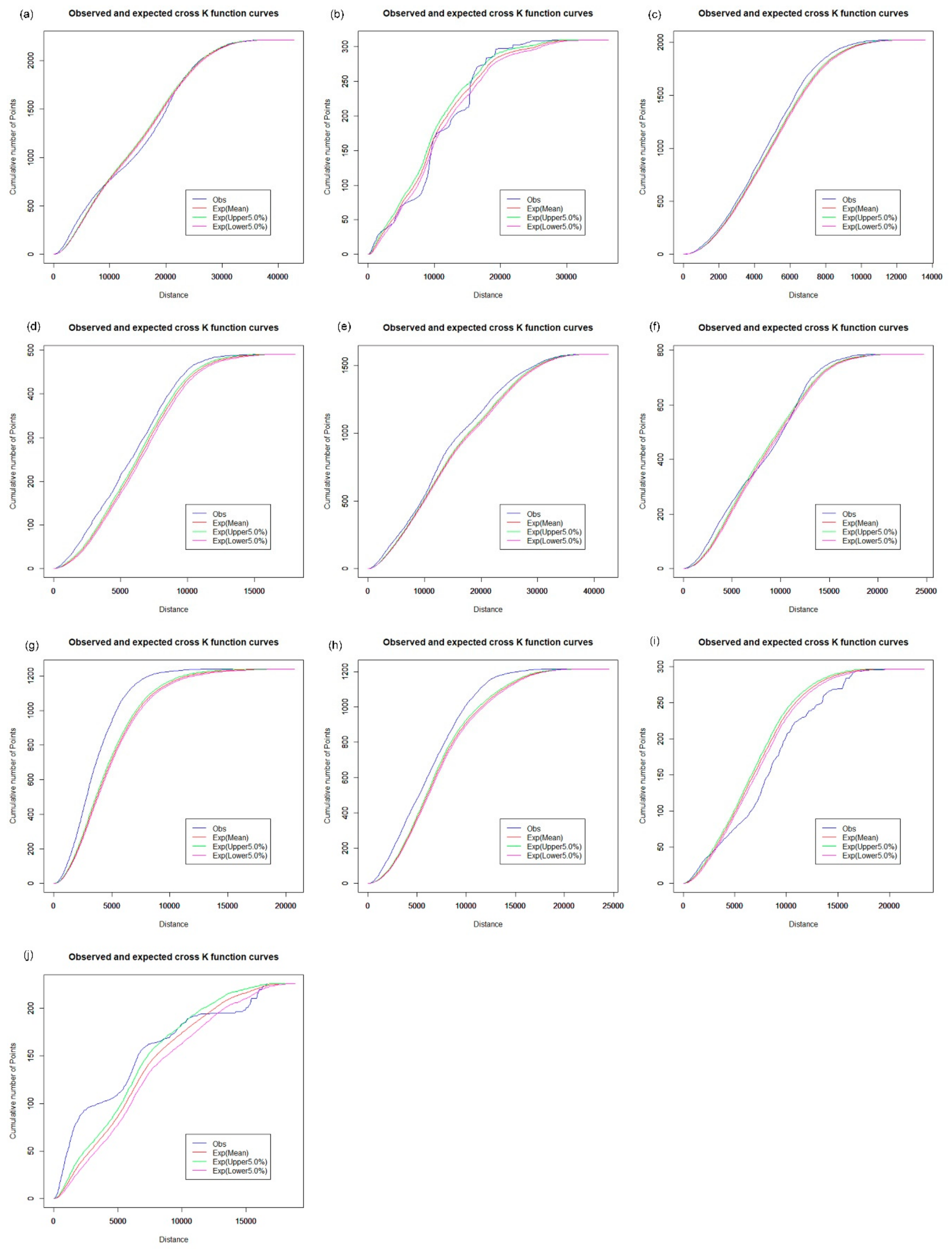
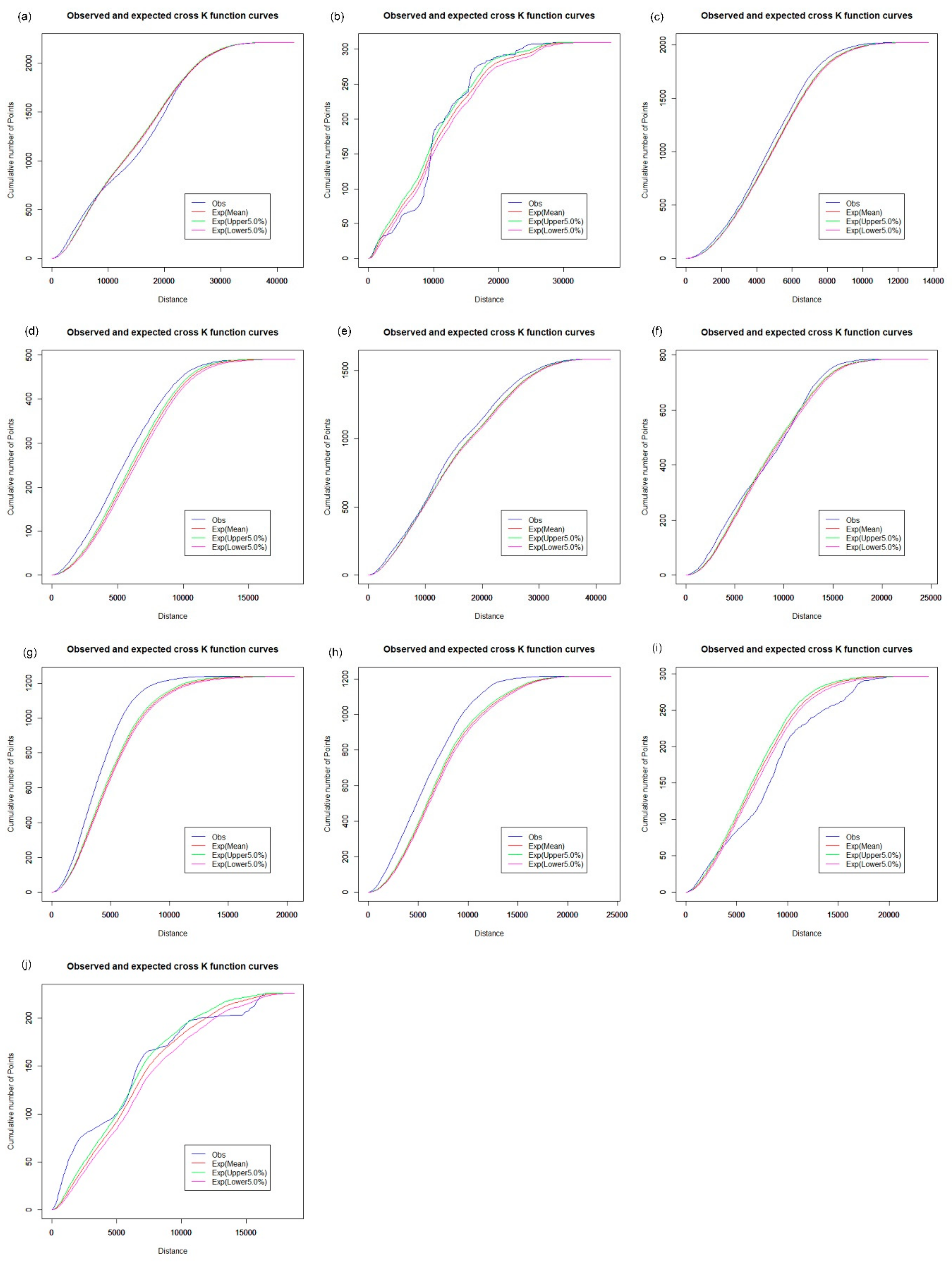
2.4. Network K-Function
2.5. Spatial Stratified Heterogeneity Analyses
3. Results and Discussion
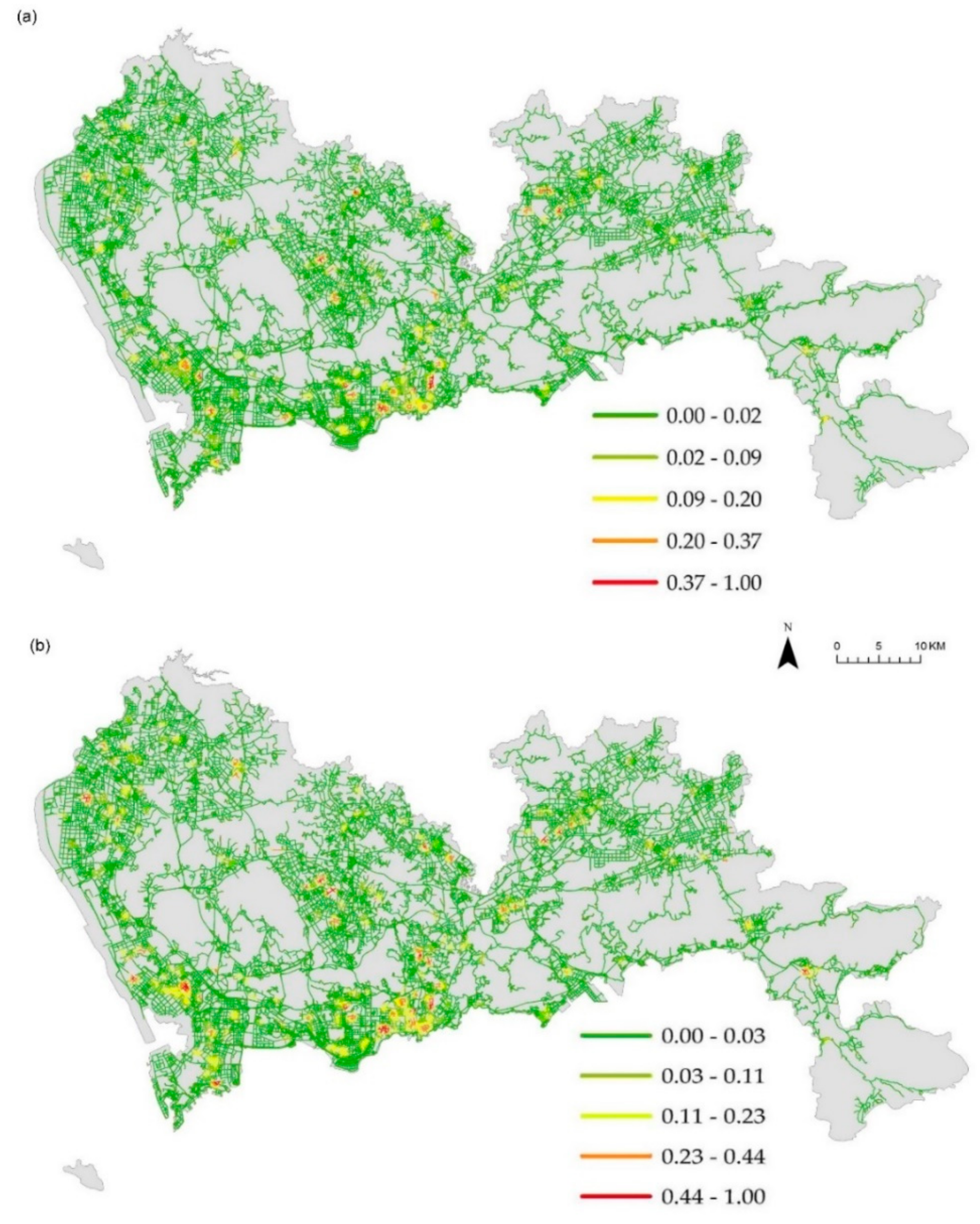
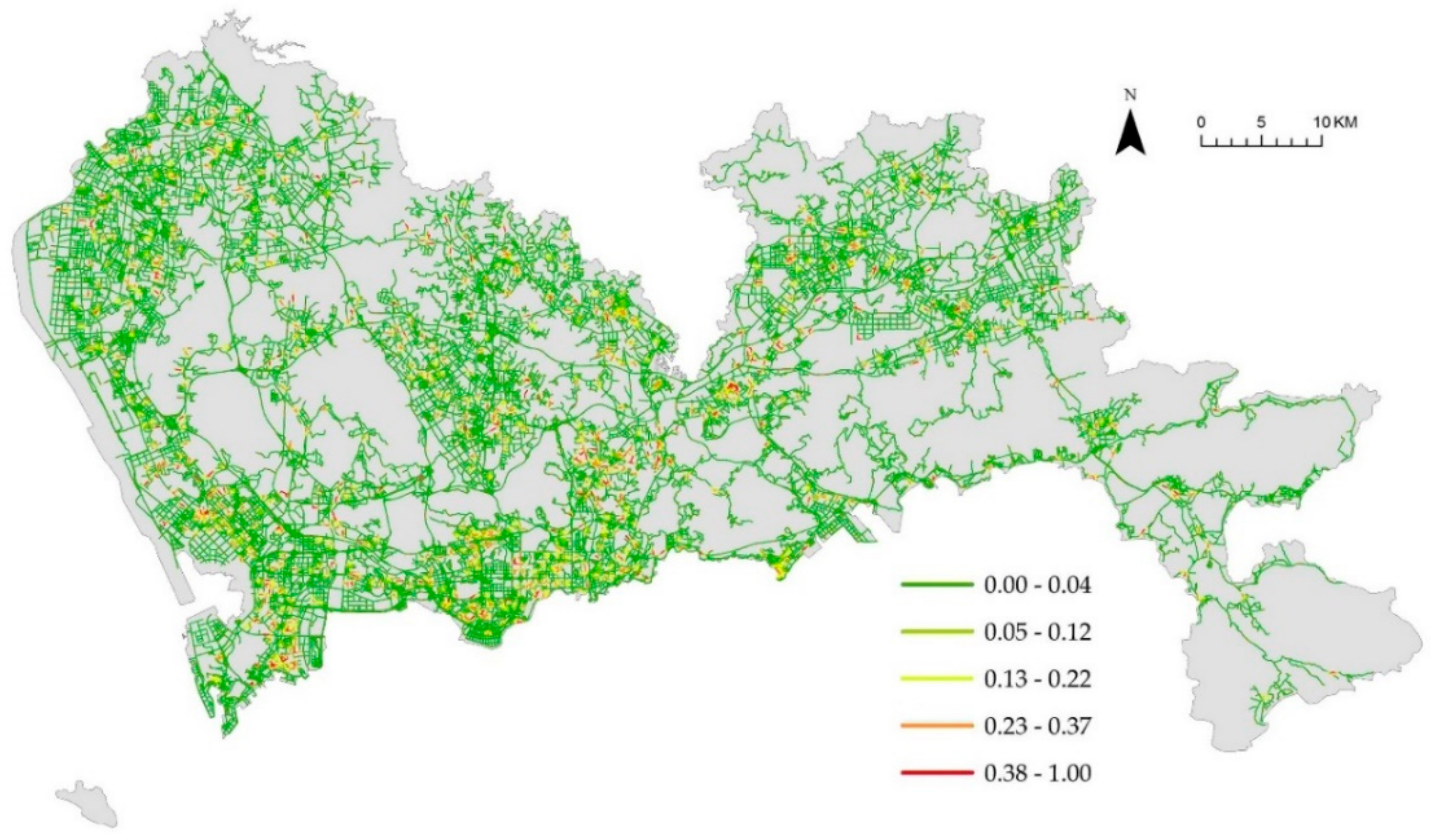
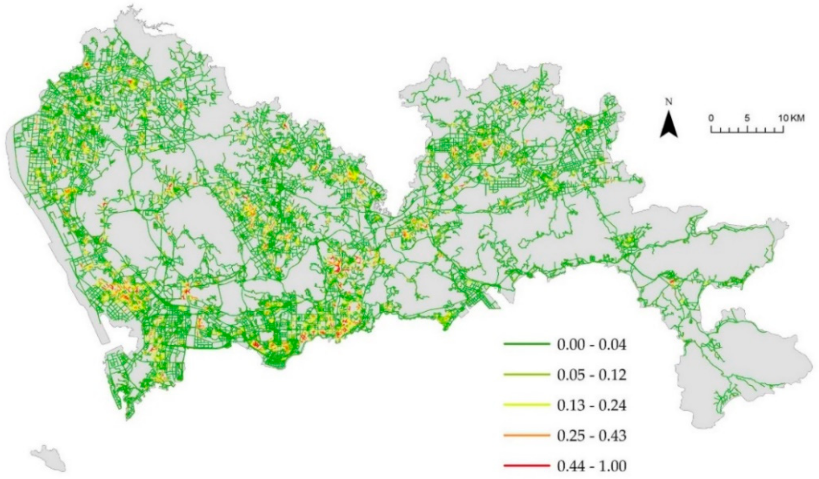
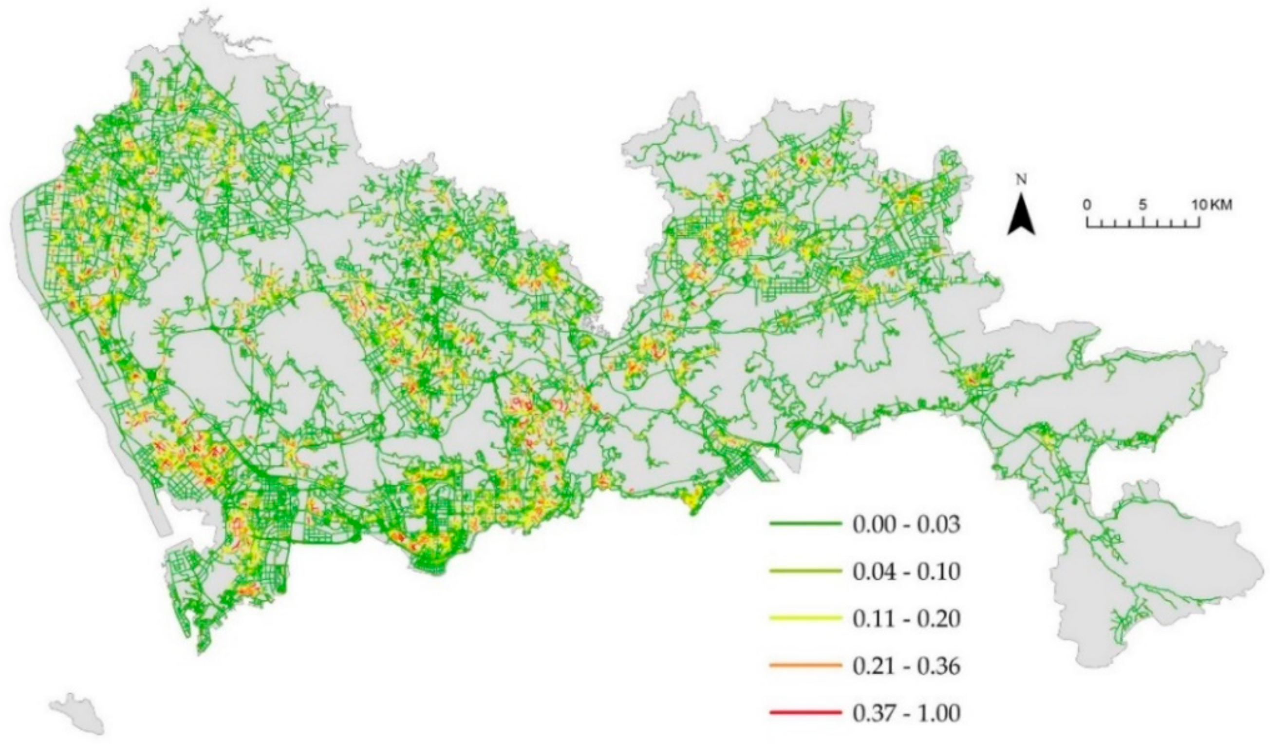
3.1. NetKDE Analysis of Health Care Facilities
3.2. Spatial Cluster Pattern Analysis
4. Conclusions
Author Contributions
Funding
Acknowledgments
Conflicts of Interest
References
- Younger, D.S. Health Care in China. Neurol. Clin. 2016, 34, 1115–1125. [Google Scholar] [CrossRef] [PubMed]
- Lam, K.K.; Johnston, J.M. Health insurance and healthcare utilisation for Shenzhen residents: A tale of registrants and migrants? BMC Public Health 2012, 12, 868. [Google Scholar] [CrossRef] [PubMed]
- Ouyang, W.; Wang, B.; Tian, L.; Niu, X. Spatial deprivation of urban public services in migrant enclaves under the context of a rapidly urbanizing China: An evaluation based on suburban Shanghai. Cities 2016, 33, 472–480. [Google Scholar] [CrossRef]
- Jin, C.; Cheng, J.; Lu, Y.; Huang, Z.; Cao, F. Spatial inequity in access to healthcare facilities at a county level in a developing country: A case study of Deqing County, Zhejiang, China. Int. J Equity Health 2015, 14. [Google Scholar] [CrossRef] [PubMed]
- Li, X.; Li, Z.; Liu, C.; Zhang, J.; Sun, Z.; Feng, Y.; Yang, S. Evaluation of the three-in-one team-based care model on hierarchical diagnosis and treatment patterns among patients with diabetes: A retrospective cohort study using Xiamen’s regional electronic health records. BMC Health Serv. Res. 2017, 17. [Google Scholar] [CrossRef] [PubMed]
- Yip, W.C.; Hsiao, W.C.; Chen, W.; Hu, S.; Ma, J.; Maynard, A. Early appraisal of China’s huge and complex health-care reforms. Lancet 2012, 379, 833–842. [Google Scholar] [CrossRef]
- Liu, G.G.; Vortherms, S.A.; Hong, X. China’s Health Reform Update. Annu. Rev. Publ. Health 2017, 38, 431–448. [Google Scholar] [CrossRef]
- Tang, S.; Ehiri, J.; Long, Q. China’s biggest, most neglected health challenge: Non-communicable diseases. Infect. Dis. Poverty 2013, 2, 6–11. [Google Scholar] [CrossRef]
- Lu, J.; Lu, Y.; Wang, X.; Li, X.; Linderman, G.C.; Wu, C.; Su, M. Prevalence, awareness, treatment, and control of hypertension in China: Data from 1.7 million adults in a population-based screening study (China PEACE Million Persons Project). Lancet 2017, 390, 2549–2558. [Google Scholar] [CrossRef]
- Tian, S.; Dong, G.H.; Wang, D.; Liu, M.M.; Lin, Q.; Meng, X.J.; Ren, Y.F. Factors associated with prevalence, awareness, treatment and control of hypertension in urban adults from 33 communities in China: The CHPSNE Study. Hypertens. Res. 2011, 34, 1087–1092. [Google Scholar] [CrossRef]
- Wang, Z.; Du, Q.; Liang, S.; Nie, K.; Lin, D.; Chen, Y.; Li, J.J. Analysis of the Spatial Variation of Hospitalization Admissions for Hypertension Disease in Shenzhen, China. Int. J. Environ. Res. Public Health 2014, 11, 713–733. [Google Scholar] [CrossRef] [PubMed] [Green Version]
- Guagliardo, M.F. Spatial accessibility of primary care: Concepts, methods and challenges. Int. J. Health Geogr 2004, 3, 3. [Google Scholar] [CrossRef] [PubMed]
- Wang, F. Measurement, Optimization, and Impact of Health Care Accessibility: A Methodological Review. Ann. Assoc. Am. Geogr. 2012, 102, 1104–1112. [Google Scholar] [CrossRef] [PubMed] [Green Version]
- Levesque, J.F.; Harris, M.F.; Russell, G. Patient-centred access to health care: Conceptualising access at the interface of health systems and populations. Int. J. Equity Health 2013, 12, 18. [Google Scholar] [CrossRef] [PubMed]
- Lankila, T.; Näyhä, S.; Rautio, A.; Rusanen, J.; Taanila, A.; Koiranen, M. Is geographical distance a barrier in the use of public primary health services among rural and urban young adults? Experience from Northern Finland. Public Health 2016, 131, 82–91. [Google Scholar] [CrossRef] [PubMed]
- Nieves, J.J. Combining Transportation Network Models with Kernel Density Methods to Measure the Relative Spatial Accessibility of Pediatric Primary Care Services in Jefferson County, Kentucky. Int. J. Appl. Geospatial Res. (IJAGR) 2015, 6, 39–57. [Google Scholar] [CrossRef] [Green Version]
- Fransen, K.; Neutens, T.; De Maeyer, P.; Deruyter, G. A commuter-based two-step floating catchment area method for measuring spatial accessibility of daycare centers. Health Place 2015, 32, 65–73. [Google Scholar] [CrossRef] [PubMed]
- Chen, A.Y.; Yu, T. Network based temporary facility location for the Emergency Medical Services considering the disaster induced demand and the transportation infrastructure in disaster response. Transport. Res. B Meth. 2016, 91, 408–423. [Google Scholar] [CrossRef]
- Shishebori, D. Yousefi Babadi, A. Robust and reliable medical services network design under uncertain environment and system disruptions. Transport. Res. E Log. 2015, 77, 268–288. [Google Scholar] [CrossRef]
- Zhang, G.X.; Fan, J.; Chan, F.; Leung, G.; Lo, C.M.; Yu, Y.M.; Jansen, J.O. An Exploratory Analysis of the Geographical Distribution of Trauma Incidents in Shenzhen, China. World J. Surg. 2017, 41, 2207–2214. [Google Scholar] [CrossRef]
- De Mello-Sampayo, F. Spatial Interaction Healthcare Accessibility Model—An Application to Texas. Appl. Spatial Anal. Policy 2018, 11, 739–751. [Google Scholar] [CrossRef]
- Gatrell, A.C. Distance and Space: A Geographical Perspective; Oxford University Press: Oxford, UK, 1983. [Google Scholar]
- Haining, R.P. Spatial Data Analysis: Theory and Practice; Cambridge University Press: Cambridge, UK, 2003. [Google Scholar]
- Illian, J.; Penttinen, A.; Stoyan, H.; Stoyan, D. Statistical Analysis and Modelling of Spatial Point Patterns; John Wiley & Sons: Hoboken, NJ, USA, 2008. [Google Scholar]
- Wang, Z.; Yue, Y.; Li, Q.; Nie, K.; Yu, C. Analysis of the Spatial Variation of Network-Constrained Phenomena Represented by a Link Attribute Using a Hierarchical Bayesian Model. ISPRS Int. J. Geo. Inf. 2017, 2, 44. [Google Scholar] [CrossRef]
- Yamada, I.; Thill, J. Local Indicators of Network-Constrained Clusters in Spatial Point Patterns. Geogr. Anal. 2007, 39, 268–292. [Google Scholar] [CrossRef]
- Okabe, A.; Okunuki, K.; Shiode, S. SANET: A Toolbox for Spatial Analysis on a Network. Geogr. Anal. 2006, 38, 57–66. [Google Scholar] [CrossRef]
- Xie, Z.; Yan, J. Kernel density estimation of traffic accidents in a network space. Comput. Environ. Urban 2008, 32, 396–406. [Google Scholar] [CrossRef]
- Ni, J.; Qian, T.; Xi, C.; Rui, Y.; Wang, J. Spatial Distribution Characteristics of Healthcare Facilities in Nanjing: Network Point Pattern Analysis and Correlation Analysis. Int. J. Environ. Res. Public Health 2016, 13, 833. [Google Scholar] [CrossRef] [PubMed] [Green Version]
- Kapwata, T.; Manda, S. Geographic assessment of access to health care in patients with cardiovascular disease in South Africa. BMC Health Serv. Res. 2018, 18, 197. [Google Scholar] [CrossRef]
- Okabe, A.; Satoh, T.; Sugihara, K. A kernel density estimation method for networks, its computational method and a GIS-based tool. Int. J. Geogr. Inf. Sci. 2009, 23, 7–32. [Google Scholar] [CrossRef]
- Nie, K.; Wang, Z.; Du, Q.; Ren, F.; Tian, Q. A Network-Constrained Integrated Method for Detecting Spatial Cluster and Risk Location of Traffic Crash: A Case Study from Wuhan, China. Sustainability 2015, 7, 2662–2677. [Google Scholar] [CrossRef] [Green Version]
- Okabe, A.; Yamada, I. The K-Function Method on a Network and Its Computational Implementation. Geogr. Anal. 2001, 33, 271–290. [Google Scholar] [CrossRef]
- Yamada, I.; Thill, J. Comparison of planar and network K-functions in traffic accident analysis. J. Trans. Geogr. 2004, 12, 149–158. [Google Scholar] [CrossRef]
- National Bureau of Statistics of China. Shenzhen Statistical Yearbook; China Statistics Press: Beijing, China, 2015. [Google Scholar]
- Zhang, D.; Mou, J.; Cheng, J.Q.; Griffiths, S.M. Public health services in Shenzhen: A case study. Public Health 2011, 125, 15–19. [Google Scholar] [CrossRef] [PubMed]
- Tian, Q.; Ren, F.; Hu, T.; Liu, J.; Li, R.; Du, Q. Using an Optimized Chinese Address Matching Method to Develop a Geocoding Service: A Case Study of Shenzhen, China. ISPRS Int. J. Geo. In. 2016, 5, 65. [Google Scholar] [CrossRef]
- Xie, Z.; Yan, J. Detecting traffic accident clusters with network kernel density estimation and local spatial statistics: An integrated approach. J. Transp. Geogr. 2013, 31, 64–71. [Google Scholar] [CrossRef]
- Okabe, A.; Sugihara, K. Spatial Analysis Along Networks: Statistical and Computational Methods; John Wiley & Sons Ltd.: Hoboken, NJ, USA, 2012. [Google Scholar]
- Yamada, I.; Thill, J. Local indicators of network-constrained clusters in spatial patterns represented by a link attribute. Ann. Assoc. Am. Geogr. 2010, 100, 269–285. [Google Scholar] [CrossRef]
- Wang, J.; Li, X.; Christakos, G.; Liao, Y.; Zhang, T.; Gu, X.; Zheng, X.Y. Geographical Detectors-Based Health Risk Assessment and its Application in the Neural Tube Defects Study of the Heshun Region, China. Int. J. Geogr. Inf. Sci. 2010, 24, 107–127. [Google Scholar] [CrossRef]
- Wang, J.; Zhang, T.; Fu, B. A measure of spatial stratified heterogeneity. Ecol. Indic. 2016, 67, 250–256. [Google Scholar] [CrossRef]
- Wang, Z.; Yue, Y.; Li, Q.; Nie, K.; Tu, W.; Liang, S. Analyzing Risk Factors for Fatality in Urban Traffic Crashes: A Case Study of Wuhan, China. Sustainability 2017, 9, 897. [Google Scholar] [CrossRef]
- Yu, W.; Ai, T.; Shao, S. The analysis and delimitation of Central Business District using network kernel density estimation. J. Trans. Geogr. 2015, 45, 32–47. [Google Scholar] [CrossRef]
- Li, X.; Lu, J.; Hu, S.; Cheng, K.K.; De Maeseneer, J.; Meng, Q.; Krumholz, H.M. The primary health-care system in China. Lancet 2017, 390, 2584–2594. [Google Scholar] [CrossRef]


| Types | Interaction Detector C = A ∩ B 1 | Linear Combination A + B | Interpretation | |
|---|---|---|---|---|
| Hospital | population ∩ road = 0.086 | < | 0.101 = population (0.037) + road (0.064) | 1 |
| CHC | population ∩ road = 0.046 | > | 0.018 = population (0.009) + road(0.009) | 2 |
| Clinic | population ∩ road = 0.086 | > | 0.056 = population (0.034) + road (0.022) | |
| Pharmacy | population ∩ road = 0.098 | > | 0.043 = population (0.020) + road(0.023) | |
| Aggregate value | population ∩ road = 0.087 | > | 0.046 = population (0.022) + road (0.024) |
© 2019 by the authors. Licensee MDPI, Basel, Switzerland. This article is an open access article distributed under the terms and conditions of the Creative Commons Attribution (CC BY) license (http://creativecommons.org/licenses/by/4.0/).
Share and Cite
Wang, Z.; Nie, K. Measuring Spatial Patterns of Health Care Facilities and Their Relationships with Hypertension Inpatients in a Network-Constrained Urban System. Int. J. Environ. Res. Public Health 2019, 16, 3204. https://0-doi-org.brum.beds.ac.uk/10.3390/ijerph16173204
Wang Z, Nie K. Measuring Spatial Patterns of Health Care Facilities and Their Relationships with Hypertension Inpatients in a Network-Constrained Urban System. International Journal of Environmental Research and Public Health. 2019; 16(17):3204. https://0-doi-org.brum.beds.ac.uk/10.3390/ijerph16173204
Chicago/Turabian StyleWang, Zhensheng, and Ke Nie. 2019. "Measuring Spatial Patterns of Health Care Facilities and Their Relationships with Hypertension Inpatients in a Network-Constrained Urban System" International Journal of Environmental Research and Public Health 16, no. 17: 3204. https://0-doi-org.brum.beds.ac.uk/10.3390/ijerph16173204