
Worldwide Research Trends in Landslide Science

 , , ,
, , , 

Abstract
:1. Introduction
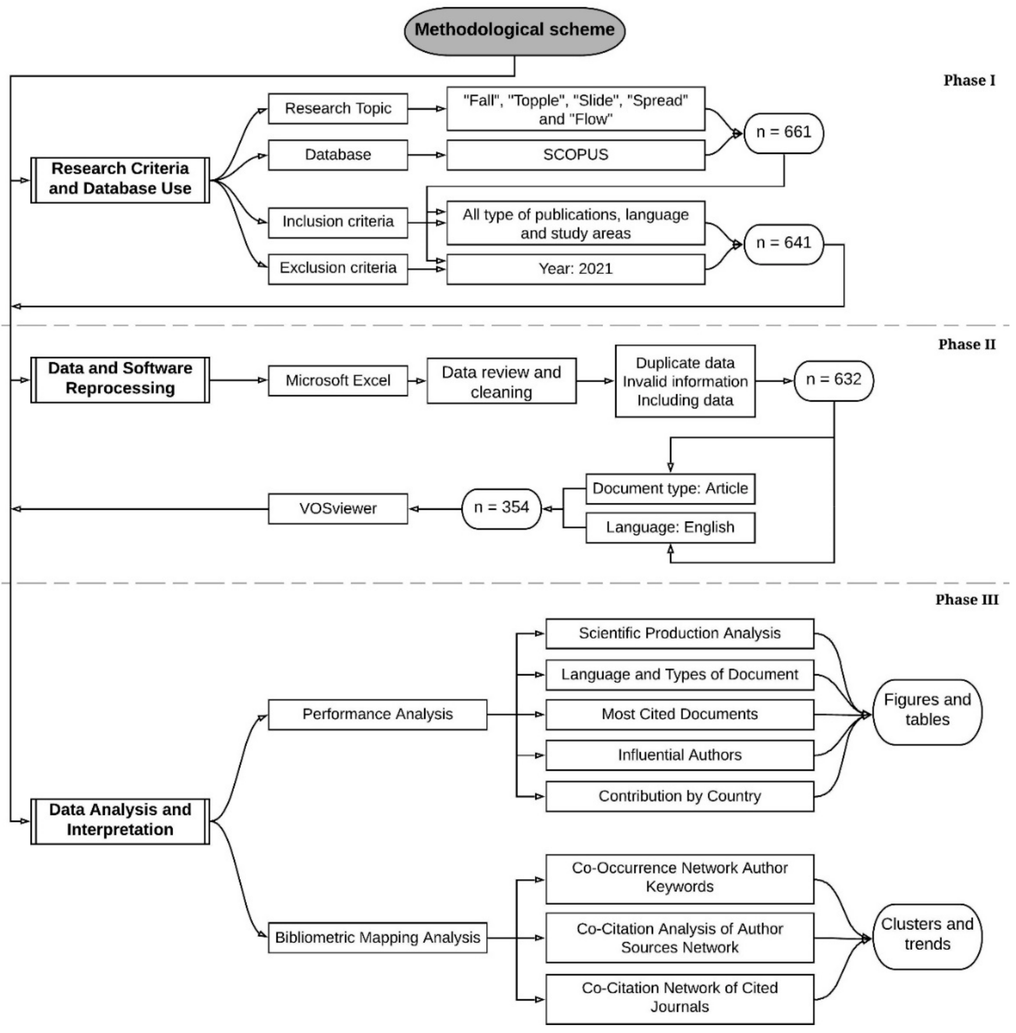
2. Materials and Methods
2.1. Phase I. Research Criteria and Database Use
2.2. Phase II. Data and Software Reprocessing
2.3. Phase III. Data Analysis and Interpretation
- sciences mapping allows the graphic representation of the cognitive structure of the study field and its evolution [41,89]. It is considered to apply a triangulation method that allows an analysis of this structure by examining its micro (keywords), meso (articles and authors) and macro (journals) components [90].
3. Results
3.1. Performance Analysis
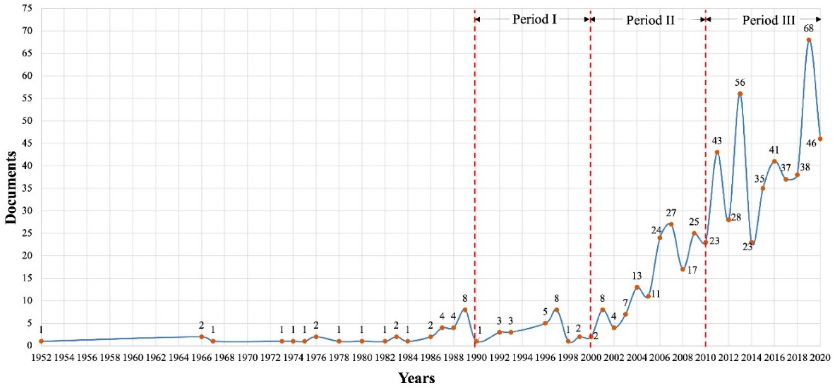
3.1.1. Scientific Production
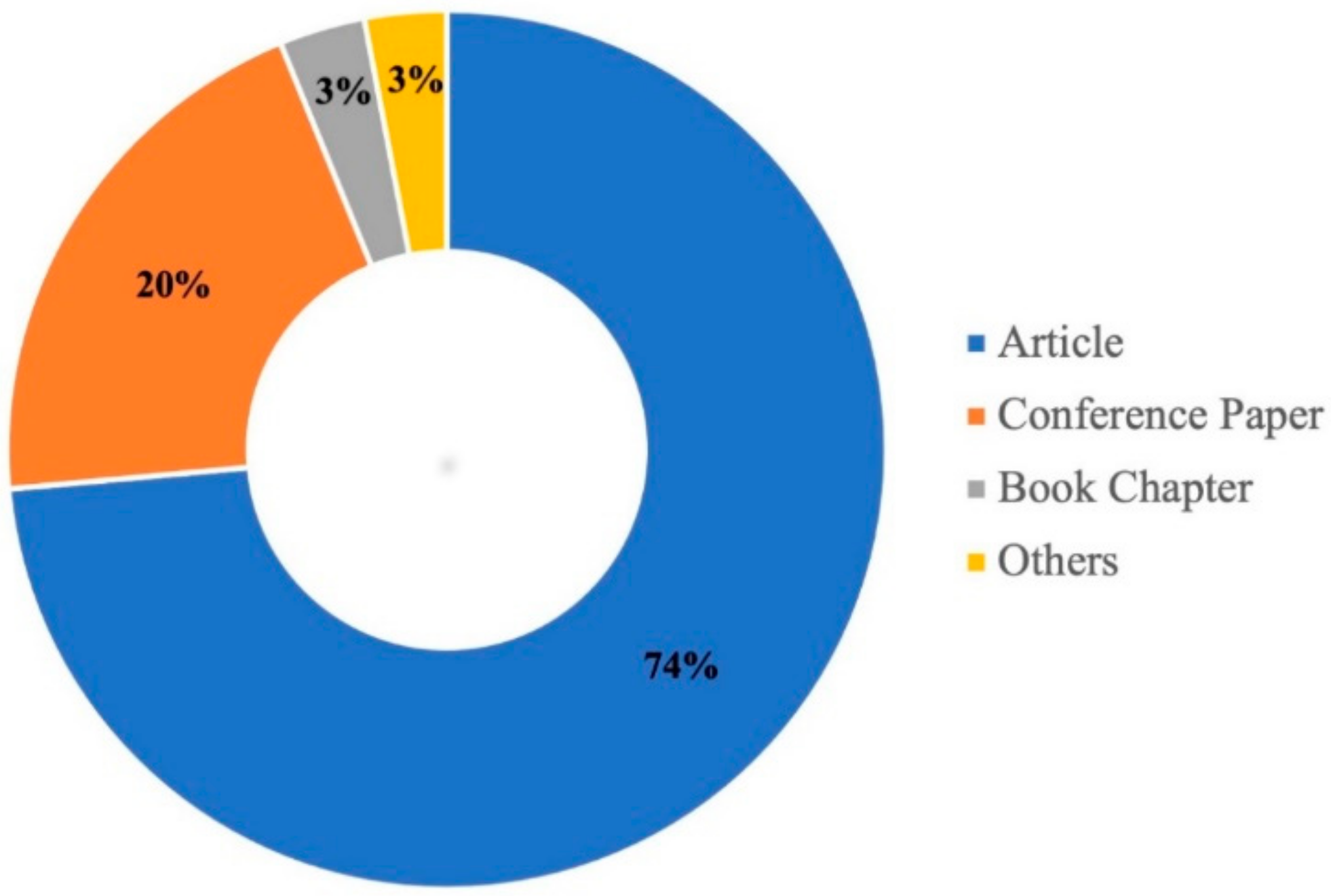
3.1.2. Language and Types of Documents
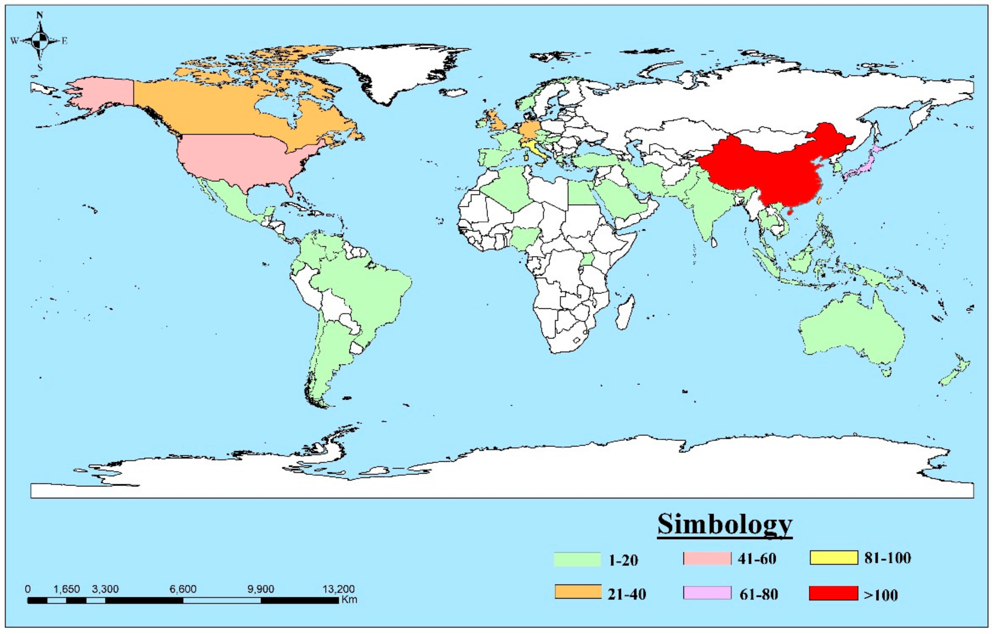
3.1.3. Contribution by Country
3.2. Bibliometric Mapping Analysis
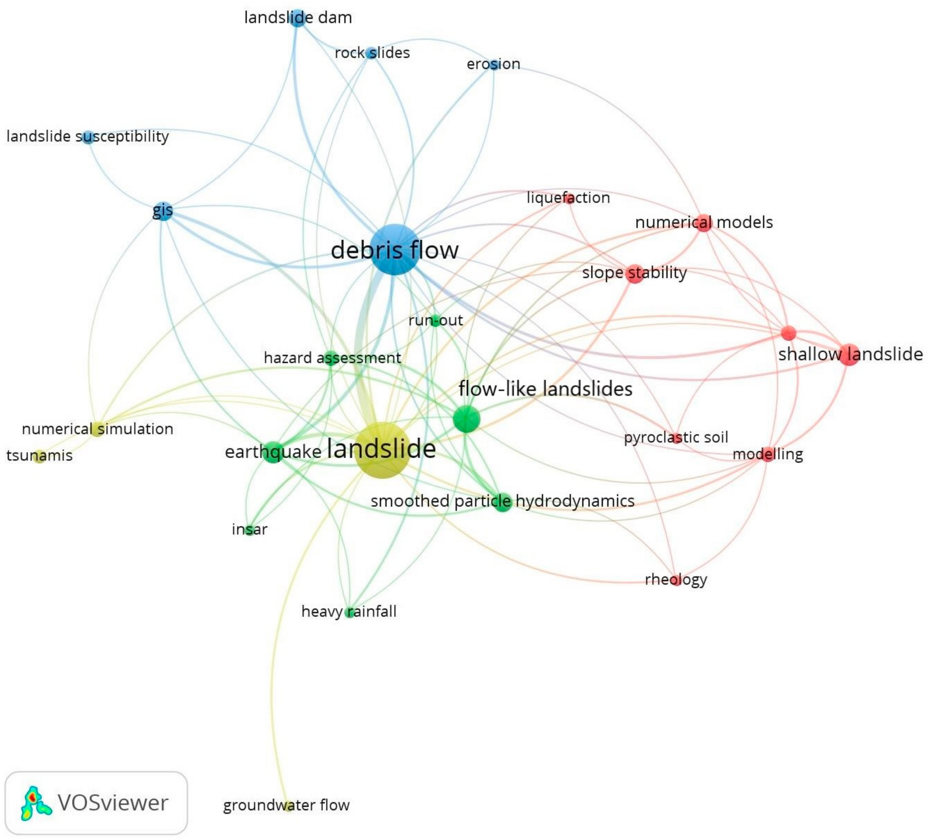
3.2.1. Co-Occurrence Author Keyword Network
3.2.2. Co-Citation Analysis
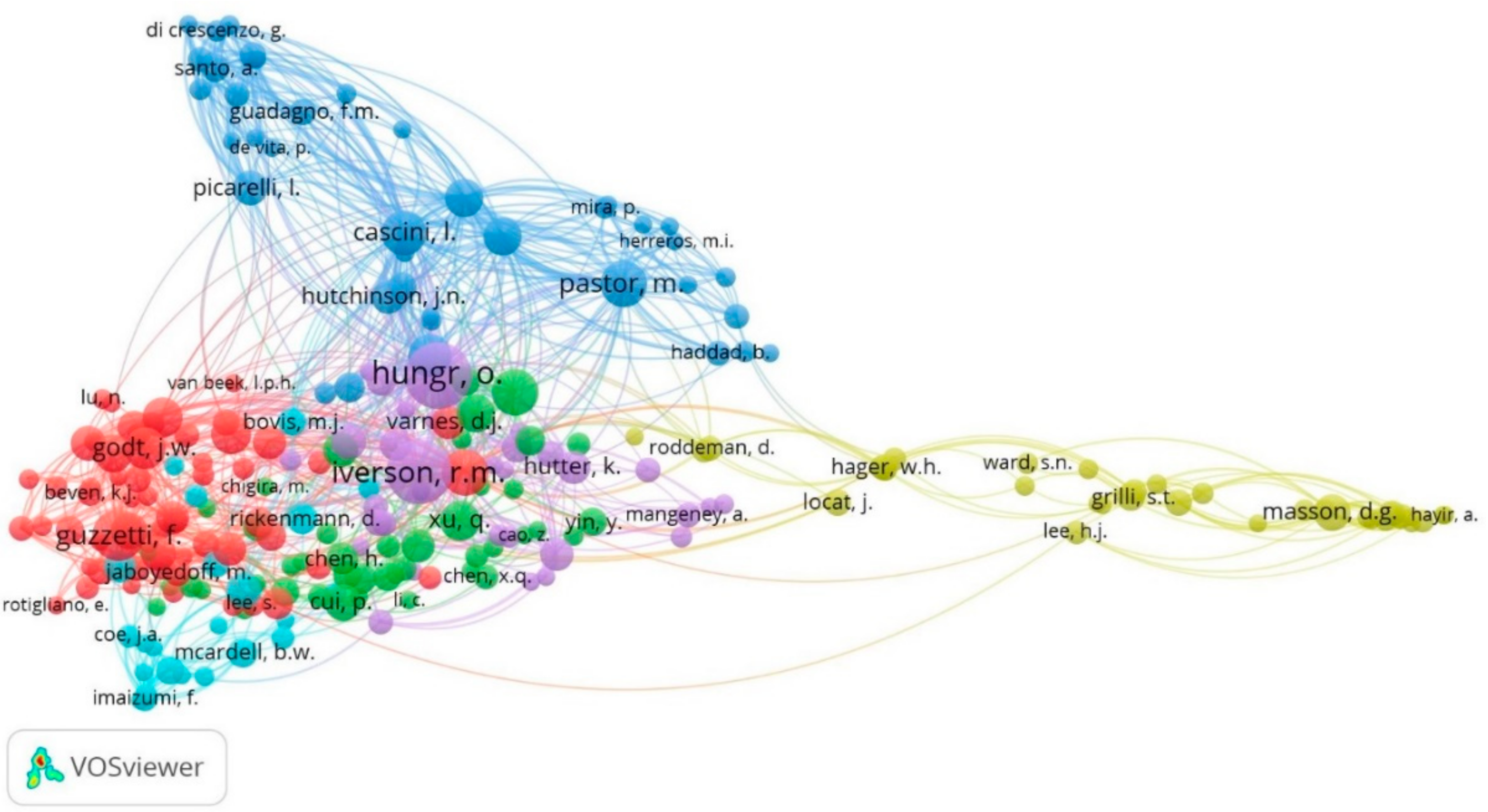
Author Co-Citation Analysis (ACA)
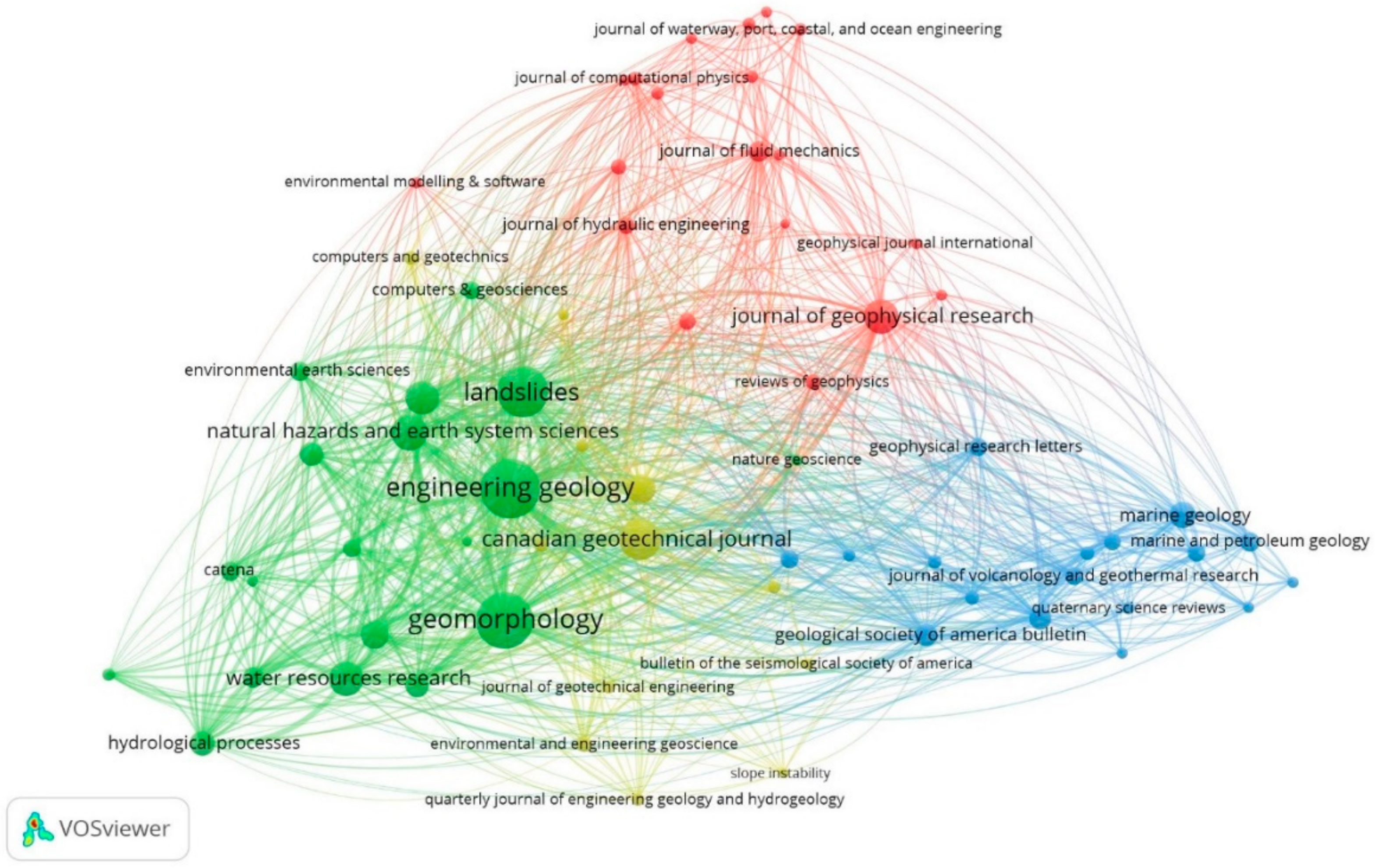
Journal Co-Citation Analysis (JCA)
4. Discussion
5. Conclusions
- The analysis of the hydraulic properties and the circumstances by which landslides can be generated as a flow;
- a deeper analysis in the study of shallow landslides and their propagation in debris flow and flow-like landslides;
- analysis of landslides from the point of view of rheology, focusing on the movement of materials caused by earthquakes and rainfalls, among others;
- generation of models through the Smoothed-Particle Hydrodynamics (SPH) method, which has been widely used for cases such as debris flow, shallow landslides, and other types of mass movements such as flows;
- implementation of satellite images in the areas of the different landslides, where the most widely implemented methods are: Interferometric Synthetic Aperture Radar (InSAR), Unmanned Aerial Vehicle (UAV), and Geographic Information System (GIS);
- stabilization studies in landslide dams, which can be caused by rainfalls and subsequent generation of debris flow;
- a technical and geological analysis on topics related to submarine landslides, among which run-out analysis and the propagation of tsunamis due to landslides and earthquakes stand out, this being an area of study that is evolving.
Author Contributions
Funding
Institutional Review Board Statement
Informed Consent Statement
Data Availability Statement
Acknowledgments
Conflicts of Interest
References
- Petley, D. Global patterns of loss of life from landslides. Geology 2012, 40, 927–930. [Google Scholar] [CrossRef]
- Vranken, L.; Van Turnhout, P.; Van Den Eeckhaut, M.; Vandekerckhove, L.; Poesen, J. Economic valuation of landslide damage in hilly regions: A case study from Flanders, Belgium. Sci. Total Environ. 2013, 447, 323–336. [Google Scholar] [CrossRef] [PubMed] [Green Version]
- Vranken, L.; Vantilt, G.; Van Den Eeckhaut, M.; Vandekerckhove, L.; Poesen, J. Landslide risk assessment in a densely populated hilly area. Landslides 2015, 12, 787–798. [Google Scholar] [CrossRef]
- Palmisano, F.; Vitone, C.; Cotecchia, F. Assessment of Landslide Damage to Buildings at the Urban Scale. J. Perform. Constr. Facil. 2018, 32, 04018055. [Google Scholar] [CrossRef]
- Pradhan, B. Remote sensing and GIS-based landslide hazard analysis and cross-validation using multivariate logistic regression model on three test areas in Malaysia. Adv. Space Res. 2010, 45, 1244–1256. [Google Scholar] [CrossRef]
- Conforti, M.; Ietto, F. An integrated approach to investigate slope instability affecting infrastructures. Bull. Eng. Geol. Environ. 2019, 78, 2355–2375. [Google Scholar] [CrossRef]
- Shepakd, F. Delta-Front: Valleys Bordering the Mississippi Distributaries. Geol. Soc. Am. Bull. 1955, 66, 1489–1498. [Google Scholar] [CrossRef]
- Cotecchia, F.; Vitone, C.; Santaloia, F.; Pedone, G.; Bottiglieri, O. Slope instability processes in intensely fissured clays: Case histories in the Southern Apennines. Landslides 2015, 12, 877–893. [Google Scholar] [CrossRef]
- Rodríguez, C.E.; Bommer, J.J.; Chandler, R.J. Earthquake-induced landslides: 1980–1997. Soil Dyn. Earthq. Eng. 1999, 18, 325–346. [Google Scholar] [CrossRef]
- Alcántara-Ayala, I. Geomorphology, natural hazards, vulnerability and prevention of natural disasters in developing countries. Geomorphology 2002, 47, 107–124. [Google Scholar] [CrossRef]
- Gokceoglu, C.; Sezer, E. A statistical assessment on international landslide literature (1945–2008). Landslides 2009, 6, 345–351. [Google Scholar] [CrossRef]
- Kockelman, W. Some techniques for reducing landslide hazards. Bull. Assoc. Eng. Geol. 1986, XXIII, 29–52. [Google Scholar] [CrossRef]
- Wu, X.; Chen, X.; Zhan, F.B.; Hong, S. Global research trends in landslides during 1991–2014: A bibliometric analysis. Landslides 2015, 12, 1215–1226. [Google Scholar] [CrossRef]
- Galve, J.P.; Cevasco, A.; Brandolini, P.; Piacentini, D.; Azañón, J.M.; Notti, D.; Soldati, M. Cost-based analysis of mitigation measures for shallow-landslide risk reduction strategies. Eng. Geol. 2016, 213, 142–157. [Google Scholar] [CrossRef]
- Gutiérrez, F.; Soldati, M.; Audemard, F.; Bălteanu, D. Recent advances in landslide investigation: Issues and perspectives. Geomorphology 2010, 124, 95–101. [Google Scholar] [CrossRef]
- Colesanti, C.; Wasowski, J. Investigating landslides with space-borne Synthetic Aperture Radar (SAR) interferometry. Eng. Geol. 2006, 88, 173–199. [Google Scholar] [CrossRef]
- Van Westen, C.J.; Rengers, N.; Soeters, R. Use of Geomorphological Information in Indirect Landslide Susceptibility Assessment. Nat. Hazards 2003, 30, 399–419. [Google Scholar] [CrossRef]
- Conforti, M.; Ietto, F. Influence of Tectonics and Morphometric Features on the Landslide Distribution: A Case Study from the Mesima Basin (Calabria, South Italy). J. Earth Sci. 2020, 31, 393–409. [Google Scholar] [CrossRef]
- Gili, J.A.; Corominas, J.; Rius, J. Using Global Positioning System techniques in landslide monitoring. Eng. Geol. 2000, 55, 167–192. [Google Scholar] [CrossRef]
- Soldati, M.; Devoto, S.; Prampolini, M.; Pasuto, A. The Spectacular Landslide-Controlled Landscape of the Northwestern Coast of Malta. In Landscapes and Landforms of the Maltese Islands; Springer: Cham, Switzerland, 2019; pp. 167–178. [Google Scholar]
- Quesada-Román, A.; Fallas-López, B.; Hernández-Espinoza, K.; Stoffel, M.; Ballesteros-Cánovas, J.A. Relationships between earthquakes, hurricanes, and landslides in Costa Rica. Landslides 2019, 16, 1539–1550. [Google Scholar] [CrossRef]
- Borgatti, L.; Soldati, M. Landslides and climatic change. Geomorphol. Hazards Disaster Prev. 2010, 87–96. [Google Scholar] [CrossRef]
- Borgatti, L.; Soldati, M. Hillslope Processes and Climate Change. In Treatise on Geomorphology; Elsevier: Amsterdam, The Netherlands, 2013; pp. 306–319. [Google Scholar]
- Morante, F.; Aguilar, M.; Ramírez, G.; Blanco, R.; Carrión, P.; Briones, J.; Berrezueta, E. Evaluation of slope stability considering the preservation of the general patrimonial cemetery of guayaquil, Ecuador. Geoscience 2019, 9, 103. [Google Scholar] [CrossRef] [Green Version]
- Morante Carballo, F.; Carrión Mero, P.; Ángel Chávez, M.; Aguilar Aguilar, M.; Briones Bitar, J. Design of the stabilization solutions in the general patrimonial cemetery of Guayaquil, Ecuador. In Proceedings of the 17th LACCEI International Multi-Conference for Engineering, Education and Technology, Montego Bay, Jamaica, 24–26 July 2019; Latin American and Caribbean Consortium of Engineering Institutions: Boca Raton, FL, USA, 2019. [Google Scholar]
- Keefer, D.K.; Wilson, R.C.; Mark, R.K.; Brabb, E.E.; Brown Iii, W.M.; Ellen, S.D.; Harp, E.L.; Wieczorek, G.F.; Alger, C.S.; Zatkint, R.S. Real-Time Landslide Warning During Heavy Rainfall. Science 1987, 238, 921–925. [Google Scholar] [CrossRef] [PubMed]
- Rahardjo, H.; Satyanaga, A.; Leong, E.C. Unsaturated Soil Mechanics for Slope Stabilization. Southeast Asian Geotech. J. 2012, 43, 48–58. [Google Scholar]
- Alimohammadlou, Y.; Najafi, A.; Yalcin, A. Landslide process and impacts: A proposed classification method. Catena 2013, 104, 219–232. [Google Scholar] [CrossRef]
- Pelling, M. Natural Disaster and Development in a Globalizing World, 1st ed.; Routledge: London, UK, 2003; ISBN 1134466447. [Google Scholar]
- Alonso, E.E. The Failure of the Aznalcóllar Tailings Dam in SW Spain. Mine Water Environ. 2021, 40, 209–224. [Google Scholar] [CrossRef]
- Villegas, H. Multi-Temporal Study and Detailed Photogeological Mapping of the Armero Debris Flow (Colombia), Using Landsat TM 5 Images. Geocarto Int. 2003, 18, 67–74. [Google Scholar] [CrossRef]
- Kirschbaum, D.; Stanley, T.; Zhou, Y. Spatial and temporal analysis of a global landslide catalog. Geomorphology 2015, 249, 4–15. [Google Scholar] [CrossRef]
- Haque, U.; da Silva, P.F.; Devoli, G.; Pilz, J.; Zhao, B.; Khaloua, A.; Wilopo, W.; Andersen, P.; Lu, P.; Lee, J.; et al. The human cost of global warming: Deadly landslides and their triggers (1995–2014). Sci. Total Environ. 2019, 682, 673–684. [Google Scholar] [CrossRef]
- Froude, M.J.; Petley, D.N. Global fatal landslide occurrence from 2004 to 2016. Nat. Hazards Earth Syst. Sci. 2018, 18, 2161–2181. [Google Scholar] [CrossRef] [Green Version]
- Shi, P.; Kasperson, R. World Atlas of Natural Disaster Risk; Springer: Berlin/Heidelberg, Germany, 2015. [Google Scholar]
- Highland, L.M.; Bobrowsky, P. The Landslide Handbook—A Guide to Understanding Landslides; Circular 1325; Geological Survey: Reston, VA, USA, 2008. [Google Scholar]
- Intrieri, E.; Carlà, T.; Gigli, G. Forecasting the time of failure of landslides at slope-scale: A literature review. Earth-Sci. Rev. 2019, 193, 333–349. [Google Scholar] [CrossRef]
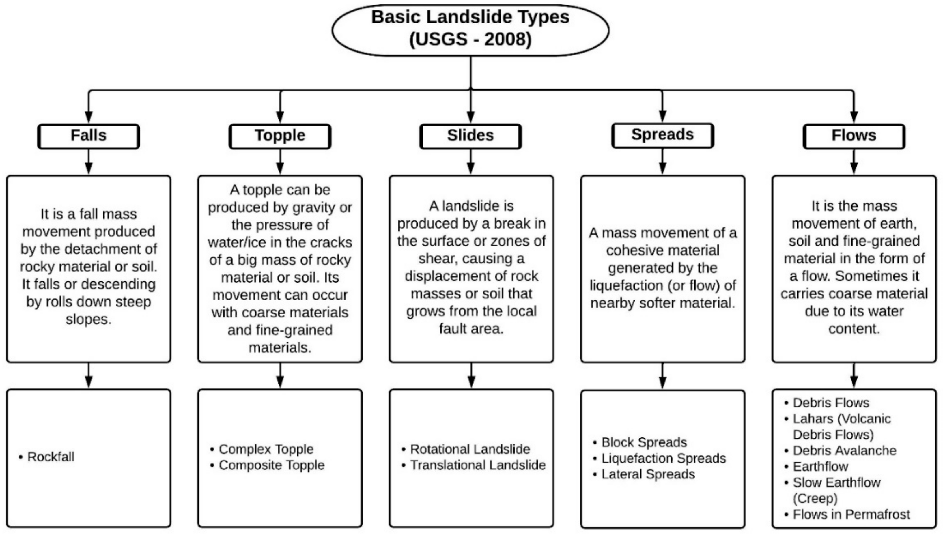
- Hungr, O.; Leroueil, S.; Picarelli, L. The Varnes classification of landslide types, an update. Landslides 2013, 11, 167–194. [Google Scholar] [CrossRef]
- Cruden, D.M.; Varnes, D.J. Landslide types and processes. In Landslides Investigation and Mitigation; Special Report 247; Turner, A.K., Schuster, R.L., Eds.; Transportation Research Board, US National Research Council: Washington, DC, USA, 1996; pp. 36–75. [Google Scholar]
- De Solla Price, D.J. Netwoks of scientific paper (Price). Science 1965, 149, 510–515. [Google Scholar] [CrossRef]
- Zupic, I.; Čater, T. Bibliometric Methods in Management and Organization. Organ. Res. Methods 2015, 18, 429–472. [Google Scholar] [CrossRef]
- Cobo, M.J.; López-Herrera, A.G.; Herrera-Viedma, E.; Herrera, F. An approach for detecting, quantifying, and visualizing the evolution of a research field: A practical application to the Fuzzy Sets Theory field. J. Inform. 2011, 5, 146–166. [Google Scholar] [CrossRef]
- Fahimnia, B.; Sarkis, J.; Davarzani, H. Green supply chain management: A review and bibliometric analysis. Int. J. Prod. Econ. 2015, 162, 101–114. [Google Scholar] [CrossRef]
- Morante-Carballo, F.; Montalván-Burbano, N.; Carrión-Mero, P.; Jácome-Francis, K. Worldwide Research Analysis on Natural Zeolites as Environmental Remediation Materials. Sustainability 2021, 13, 6378. [Google Scholar] [CrossRef]
- Denyer, D.; Tranfield, D. Producing a systematic review. In The Sage Handbook of Organizational Research Methods; Sage Publications Ltd.: Thousand Oaks, CA, USA, 2009; pp. 671–689. ISBN 978-1-4129-3118-2. [Google Scholar]
- Tranfield, D.; Denyer, D.; Smart, P. Towards a Methodology for Developing Evidence-Informed Management Knowledge by Means of Systematic Review. Br. J. Manag. 2003, 14, 207–222. [Google Scholar] [CrossRef]
- Keathley-Herring, H.; Van Aken, E.; Gonzalez-Aleu, F.; Deschamps, F.; Letens, G.; Orlandini, P.C. Assessing the maturity of a research area: Bibliometric review and proposed framework. Scientometrics 2016, 109, 927–951. [Google Scholar] [CrossRef]
- Herrera-Franco, G.; Montalván-Burbano, N.; Carrión-Mero, P.; Jaya-Montalvo, M.; Gurumendi-Noriega, M. Worldwide Research on Geoparks through Bibliometric Analysis. Sustainabilty 2021, 13, 1175. [Google Scholar] [CrossRef]
- Cancino, C.; Merigó, J.M.; Coronado, F.; Dessouky, Y.; Dessouky, M. Forty years of Computers & Industrial Engineering: A bibliometric analysis. Comput. Ind. Eng. 2017, 113, 614–629. [Google Scholar] [CrossRef]
- Gaviria-Marin, M.; Popa, S.; Merigo, J.M. Twenty years of the Journal of Knowledge Management: A bibliometric analysis. J. Knowl. Manag. 2018, 22, 1655–1687. [Google Scholar] [CrossRef] [Green Version]
- Abad-Segura, E.; Batlles de la Fuente, A.; González-Zamar, M.-D.; Belmonte-Ureña, L.J. Effects of Circular Economy Policies on the Environment and Sustainable Growth: Worldwide Research. Sustainability 2020, 12, 5792. [Google Scholar] [CrossRef]
- Montalván-Burbano, N.; Pérez-Valls, M.; Plaza-Úbeda, J. Analysis of scientific production on organizational innovation. Cogent Bus. Manag. 2020, 7, 1745043. [Google Scholar] [CrossRef]
- Abad-Segura, E.; Cortés-García, F.J. Belmonte-Ureña the Sustainable Approach to Corporate Social Responsibility: A Global Analysis and Future Trends. Sustainability 2019, 11, 5382. [Google Scholar] [CrossRef] [Green Version]
- Durán-Sánchez, A.; Álvarez-García, J.; González-Vázquez, E.; Del Río-Rama, M.D. Wastewater Management: Bibliometric Analysis of Scientific Literature. Water 2020, 12, 2963. [Google Scholar] [CrossRef]
- Herrera-Franco, G.; Montalván-Burbano, N.; Carrión-Mero, P.; Apolo-Masache, B.; Jaya-Montalvo, M. Research Trends in Geotourism: A Bibliometric Analysis Using the Scopus Database. Geosciences 2020, 10, 379. [Google Scholar] [CrossRef]
- De Sousa, F.D.B. Management of plastic waste: A bibliometric mapping and analysis. Waste Manag. Res. J. A Sustain. Circ. Econ. 2021, 39, 664–678. [Google Scholar] [CrossRef]
- Morante-Carballo, F.; Montalván-Burbano, N.; Carrión-Mero, P.; Espinoza-Santos, N. Cation Exchange of Natural Zeolites: Worldwide Research. Sustainability 2021, 13, 7751. [Google Scholar] [CrossRef]
- Chernysh, Y.; Roubík, H. International Collaboration in the Field of Environmental Protection: Trend Analysis and COVID-19 Implications. Sustainability 2020, 12, 10384. [Google Scholar] [CrossRef]
- Chiu, W.T.; Ho, Y.S. Bibliometric analysis of tsunami research. Scientometrics 2007, 73, 3–17. [Google Scholar] [CrossRef]
- Neri, M.; Milazzo, D.; Ugolini, D.; Milic, M.; Campolongo, A.; Pasqualetti, P.; Bonassi, S. Worldwide interest in the comet assay: A bibliometric study. Mutagenesis 2015, 30, 155–163. [Google Scholar] [CrossRef] [PubMed] [Green Version]
- Singh, V.K.; Singh, P.; Karmakar, M.; Leta, J.; Mayr, P. The journal coverage of Web of Science, Scopus and Dimensions: A comparative analysis. Scientometrics 2021, 126, 5113–5142. [Google Scholar] [CrossRef]
- Schotten, M.; El Aisati, M.; Meester, W.J.N.; Steiginga, S.; Ross, C.A. Research Analytics; Cantú-Ortiz, F.J., Ed.; Auerbach Publications: Boca Raton, FL, USA; Taylor & Francis: London, UK, 2017; ISBN 9781315155890. [Google Scholar]
- Martín-Martín, A.; Orduna-Malea, E.; Delgado López-Cózar, E. Coverage of highly-cited documents in Google Scholar, Web of Science, and Scopus: A multidisciplinary comparison. Scientometrics 2018, 116, 2175–2188. [Google Scholar] [CrossRef] [Green Version]
- Álvarez-García, J.; Durán-Sánchez, A.; Del Río-Rama, M.D.; García-Vélez, D.F. Active Ageing: Mapping of Scientific Coverage. Int. J. Environ. Res. Public Health 2018, 15, 2727. [Google Scholar] [CrossRef] [Green Version]
- Baas, J.; Schotten, M.; Plume, A.; Côté, G.; Karimi, R. Scopus as a curated, high-quality bibliometric data source for academic research in quantitative science studies. Quant. Sci. Stud. 2020, 1, 377–386. [Google Scholar] [CrossRef]
- Harzing, A.W.; Alakangas, S. Google Scholar, Scopus and the Web of Science: A longitudinal and cross-disciplinary comparison. Scientometrics 2016, 106, 787–804. [Google Scholar] [CrossRef]
- Montalván-Burbano, N.; Velastegui-Montoya, A.; Gurumendi-Noriega, M.; Morante-Carballo, F.; Adami, M. Worldwide Research on Land Use and Land Cover in the Amazon Region. Sustainability 2021, 13, 6039. [Google Scholar] [CrossRef]
- Briones-Bitar, J.; Carrión-Mero, P.; Montalván-Burbano, N.; Morante-Carballo, F. Rockfall research: A bibliometric analysis and future trends. Geoscience 2020, 10, 403. [Google Scholar] [CrossRef]
- Lara-Rodríguez, J.S.; Rojas-Contreras, C.; Duque Oliva, E.J. Discovering emerging research topics for brand personality: A bibliometric analysis. Australas. Mark. J. 2019, 27, 261–272. [Google Scholar] [CrossRef]
- Brennan, D. Simple export of journal citation data to Excel using any reference manager. J. Med. Libr. Assoc. 2016, 104, 72–75. [Google Scholar] [CrossRef] [Green Version]
- León-Castro, M.; Rodríguez-Insuasti, H.; Montalván-Burbano, N.; Victor, J.A. Bibliometrics and Science Mapping of Digital Marketing. In Marketing and Smart Technologies; Rocha, Á., Reis, J.L., Peter, M.K., Cayolla, R., Loureiro, S., Bogdanović, Z., Eds.; Smart Innovation, Systems and Technologies; Springer: Singapore, 2021; pp. 95–107. [Google Scholar]
- Taşkın, Z.; Aydinoglu, A.U. Collaborative interdisciplinary astrobiology research: A bibliometric study of the NASA Astrobiology Institute. Scientometrics 2015, 103, 1003–1022. [Google Scholar] [CrossRef]
- Pico-Saltos, R.; Carrión-Mero, P.; Montalván-Burbano, N.; Garzás, J.; Redchuk, A. Research Trends in Career Success: A Bibliometric Review. Sustainability 2021, 13, 4625. [Google Scholar] [CrossRef]
- Van Eck, N.J.; Waltman, L.; Dekker, R.; Van Den Berg, J. A comparison of two techniques for bibliometric mapping: Multidimensional scaling and VOS. J. Am. Soc. Inf. Sci. Technol. 2010, 61, 2405–2416. [Google Scholar] [CrossRef] [Green Version]
- van Eck, N.J.; Waltman, L. Citation-based clustering of publications using CitNetExplorer and VOSviewer. Scientometrics 2017, 111, 1053–1070. [Google Scholar] [CrossRef] [PubMed] [Green Version]
- Ye, C. Bibliometrical Analysis of International Big Data Research: Based on Citespace and VOSviewer. In Proceedings of the 14th International Conference on Natural Computation, Fuzzy Systems and Knowledge Discovery (ICNC-FSKD), Huangshan, China, 28–30 July 2018; pp. 927–932. [Google Scholar]
- Huang, T.; Wu, H.; Yang, S.; Su, B.; Tang, K.; Quan, Z.; Zhong, W.; Luo, X. Global Trends of Researches on Sacral Fracture Surgery: A Bibliometric Study Based on VOSviewer. Spine 2020, 45, E721–E728. [Google Scholar] [CrossRef] [PubMed]
- Ramos-Rodríguez, A.-R.; Ruíz-Navarro, J. Changes in the intellectual structure of strategic management research: A bibliometric study of the Strategic Management Journal, 1980–2000. Strateg. Manag. J. 2004, 25, 981–1004. [Google Scholar] [CrossRef]
- Small, H. Co-citation in the Scientific Literature: A New Measure of the Relationship Between Two Documents. J. Am. Soc. Inf. Sci. 1973, 24, 265–269. [Google Scholar] [CrossRef]
- Small, H.G. A Co-Citation Model of a Scientific Specialty: A Longitudinal Study of Collagen Research. Soc. Stud. Sci. 1977, 7, 139–166. [Google Scholar] [CrossRef]
- Ali, M.; Hussain, S.T.; Lei, S.; Shah, S.H.H.; Doronin, D. Prosumption: Bibliometric analysis using HistCite and VOSviewer. Kybernetes 2019, 49, 1020–1045. [Google Scholar] [CrossRef]
- Niñerola, A.; Sánchez-Rebull, M.-V.; Hernández-Lara, A.-B. Tourism Research on Sustainability: A Bibliometric Analysis. Sustainability 2019, 11, 1377. [Google Scholar] [CrossRef] [Green Version]
- De la Cruz del Río-Rama, M.; Maldonado-Erazo, C.P.; Álvarez-García, J.; Durán-Sánchez, A. Cultural and natural resources in tourism Island: Bibliometric mapping. Sustainability 2020, 12, 724. [Google Scholar] [CrossRef] [Green Version]
- Gao, Y.; Xu, Y.; Zhu, Y.; Zhang, J. An analysis of the hotspot and frontier of mine eco-environment restoration based on big data visualization of VOSviewer and CiteSpace. Geol. Bull. China 2018, 37, 2144–2153. [Google Scholar]
- Belmonte-Ureña, L.J.; Plaza-Úbeda, J.A.; Vazquez-Brust, D.; Yakovleva, N. Circular economy, degrowth and green growth as pathways for research on sustainable development goals: A global analysis and future agenda. Ecol. Econ. 2021, 185, 107050. [Google Scholar] [CrossRef]
- Noyons, E.C.M.; Moed, H.F.; Van Raan, A.F.J. Integrating research performance analysis and science mapping. Scientometrics 1999, 46, 591–604. [Google Scholar] [CrossRef]
- Herrera-Franco, G.; Montalván-Burbano, N.; Carrión-Mero, P.; Bravo-Montero, L. Worldwide Research on Socio-Hydrology: A Bibliometric Analysis. Water 2021, 13, 1283. [Google Scholar] [CrossRef]
- Alshehhi, A.; Nobanee, H.; Khare, N. The Impact of Sustainability Practices on Corporate Financial Performance: Literature Trends and Future Research Potential. Sustainability 2018, 10, 494. [Google Scholar] [CrossRef] [Green Version]
- Cobo, M.J.; López-Herrera, A.G.; Herrera-Viedma, E.; Herrera, F. Science mapping software tools: Review, analysis, and cooperative study among tools. J. Am. Soc. Inf. Sci. Technol. 2011, 62, 1382–1402. [Google Scholar] [CrossRef]
- Chandra, Y. Mapping the evolution of entrepreneurship as a field of research (1990–2013): A scientometric analysis. PLoS ONE 2018, 13, e0190228. [Google Scholar] [CrossRef]
- Mencl, V. Mechanics of Landslides with Non-Circular Slip Surfaces with Special Reference to the Vaiont Slide. Géotechnique 1966, 16, 329–337. [Google Scholar] [CrossRef]
- Blong, R.J. A numerical classification of selected landslides of the débris slide-avalanche-flow type. Eng. Geol. 1973, 7, 99–114. [Google Scholar] [CrossRef]
- Crandell, D.R. Landslides and rapid-flowage phenomena near Pierre, South Dakota. Econ. Geol. 1952, 47, 548–568. [Google Scholar] [CrossRef]
- Caine, N. The Rainfall Intensity—Duration Control of Shallow Landslides and Debris Flows. Geogr. Ann. Ser. A Phys. Geogr. 1980, 62, 23–27. [Google Scholar] [CrossRef]
- Iverson, R.M.; Major, J. on J. Rainfall, ground-water flow, and seasonal movement at Minor Creek landslide, northwestern California: Physical interpretation of empirical relations. GSA Bull. 1987, 99, 579–594. [Google Scholar] [CrossRef]
- Van Genuchten, P.M.B.; De Rijke, H. On pore water pressure variations causing slide velocities and accelerations observed in a seasonally active landslide. Earth Surf. Process. Landf. 1989, 14, 577–586. [Google Scholar] [CrossRef]
- King, J.; Loveday, I.; Schuster, R.L. The 1985 Bairaman landslide dam and resulting debris flow, Papua New Guinea. Q. J. Eng. Geol. Hydrogeol. 1989, 22, 257–270. [Google Scholar] [CrossRef]
- Savage, W.Z.; Chleborad, A.F. A Model for Creeping Flow in Landslides; Open-File Report 81-124; U.S. Department of the Interior, Geological Survey: Washington, DC, USA, 1981.
- Von Huene, R.; Bourgois, J.; Miller, J.; Pautot, G. A large tsunamogenic landslide and debris flow along the Peru Trench. J. Geophys. Res. Solid Earth 1989, 94, 1703–1714. [Google Scholar] [CrossRef]
- Bathurst, J.C.; Burton, A.; Ward, T.J. Debris Flow Run-Out and Landslide Sediment Delivery Model Tests. J. Hydraul. Eng. 1997, 123, 410–419. [Google Scholar] [CrossRef]
- Crosta, G. Landslide, spreading, deep seated gravitational deformation: Analysis, examples, problems and proposals. Geografia Fisica Dinamica Quaternaria 1996, 19, 297–313. [Google Scholar]
- Tadić, B. Temporally disordered granular flow: A model of landslides. Phys. Rev. E 1998, 57, 4375–4381. [Google Scholar] [CrossRef] [Green Version]
- Sousa, J.; Voight, B. Computational Flow Modeling for Long-Runout Landslide Hazard Assessment, with an Example from Clapière Landslide, France. Environ. Eng. Geosci. 1992, 29, 131–150. [Google Scholar] [CrossRef]
- Straub, S. Predictability of long runout landslide motion: Implications from granular flow mechanics. Geol. Rundsch. 1997, 86, 415–425. [Google Scholar] [CrossRef]
- Iverson, R.M.; Reid, M.E.; LaHusen, R.G. Debris-Flow Mobilization from Landslide. Annu. Rev. Earth Planet. Sci. 1997, 25, 85–138. [Google Scholar] [CrossRef]
- Phien-Wej, N.; Nutalaya, P.; Aung, Z.; Zhibin, T. Catastrophic landslides and debris flows in Thailand. Bull. Int. Assoc. Eng. Geol. 1993, 48, 93–100. [Google Scholar] [CrossRef]
- Bovis, M.J.; Jakob, M. The July 29, 1998, debris flow and landslide dam at Capricorn Creek, Mount Meager Volcanic Complex, southern Coast Mountains, British Columbia. Can. J. Earth Sci. 2000, 37, 1321–1334. [Google Scholar] [CrossRef]
- Helmstetter, A.; Sornette, D.; Grasso, J.-R.; Andersen, J.V.; Gluzman, S.; Pisarenko, V. Slider block friction model for landslides: Application to Vaiont and La Clapière landslides. J. Geophys. Res. Solid Earth 2004, 109, B02409. [Google Scholar] [CrossRef]
- Hungr, O.; Evans, S.G.; Bovis, M.J.; Hutchinson, J.N. A review of the classification of landslides of the flow type. Environ. Eng. Geosci. 2001, 7, 221–238. [Google Scholar] [CrossRef]
- Klubertanz, G.; Laloui, L.; Vulliet, L. Identification of mechanisms for landslide type initiation of debris flows. Eng. Geol. 2009, 109, 114–123. [Google Scholar] [CrossRef]
- Haeberlin, Y.; Turberg, P.; Retière, A.; Senegas, O.; Parriaux, A. Validation of Spot-5 satellite imagery for geological hazard identification and risk assessment for landslides, mud and debris flows in Matagalpa, Nicaragua. Int. Arch. Photogramm. Remote Sens. Spat. Inf. Sci 2004, 35, B1. [Google Scholar]
- McDougall, S.; Boultbee, N.; Hungr, O.; Stead, D.; Schwab, J.W. The Zymoetz River landslide, British Columbia, Canada: Description and dynamic analysis of a rock slide–debris flow. Landslides 2006, 3, 195. [Google Scholar] [CrossRef]
- Guzzetti, F.; Peruccacci, S.; Rossi, M.; Stark, C.P. The rainfall intensity–duration control of shallow landslides and debris flows: An update. Landslides 2008, 5, 3–17. [Google Scholar] [CrossRef]
- Crosta, G.B.; Frattini, P. Rainfall-induced landslides and debris flows. Hydrol. Process. 2008, 22, 473–477. [Google Scholar] [CrossRef]
- Baum, R.L.; Godt, J.W. Early warning of rainfall-induced shallow landslides and debris flows in the USA. Landslides 2010, 7, 259–272. [Google Scholar] [CrossRef]
- Chen, H.; Dadson, S.; Chi, Y.-G. Recent rainfall-induced landslides and debris flow in northern Taiwan. Geomorphology 2006, 77, 112–125. [Google Scholar] [CrossRef]
- Simoni, S.; Zanotti, F.; Bertoldi, G.; Rigon, R. Modelling the probability of occurrence of shallow landslides and channelized debris flows using GEOtop-FS. Hydrol. Process. 2008, 22, 532–545. [Google Scholar] [CrossRef]
- Cascini, L.; Cuomo, S.; Pastor, M.; Sorbino, G. Modeling of Rainfall-Induced Shallow Landslides of the Flow-Type. J. Geotech. Geoenviron. Eng. 2010, 136, 85–98. [Google Scholar] [CrossRef]
- Pastor, M.; Haddad, B.; Sorbino, G.; Cuomo, S.; Drempetic, V. A depth-integrated, coupled SPH model for flow-like landslides and related phenomena. Int. J. Numer. Anal. Methods Geomech. 2009, 33, 143–172. [Google Scholar] [CrossRef]
- Moretti, L.; Mangeney, A.; Capdeville, Y.; Stutzmann, E.; Huggel, C.; Schneider, D.; Bouchut, F. Numerical modeling of the Mount Steller landslide flow history and of the generated long period seismic waves. Geophys. Res. Lett. 2012, 39. [Google Scholar] [CrossRef] [Green Version]
- Huang, Y.; Zhang, W.; Xu, Q.; Xie, P.; Hao, L. Run-out analysis of flow-like landslides triggered by the Ms 8.0 2008 Wenchuan earthquake using smoothed particle hydrodynamics. Landslides 2012, 9, 275–283. [Google Scholar] [CrossRef]
- Dai, Z.; Huang, Y.; Cheng, H.; Xu, Q. 3D numerical modeling using smoothed particle hydrodynamics of flow-like landslide propagation triggered by the 2008 Wenchuan earthquake. Eng. Geol. 2014, 180, 21–33. [Google Scholar] [CrossRef]
- Zhang, X.; Krabbenhoft, K.; Sheng, D.; Li, W. Numerical simulation of a flow-like landslide using the particle finite element method. Comput. Mech. 2015, 55, 167–177. [Google Scholar] [CrossRef]
- Iovine, G.; Mangraviti, P. The CA-model FLOW-S* for flow-type landslides: An introductory account. In Proceedings of the 18th World IMACS/MODSIM Congress, Cairns, Australia, 13–17 July 2009. [Google Scholar]
- Long, J.; Liu, Y.; Li, C.; Fu, Z.; Zhang, H. A novel model for regional susceptibility mapping of rainfall-reservoir induced landslides in Jurassic slide-prone strata of western Hubei Province, Three Gorges Reservoir area. Stoch. Environ. Res. Risk Assess. 2020, 35, 1403–1426. [Google Scholar] [CrossRef]
- Chen, C.-Y. Event-based rainfall warning regression model for landslide and debris flow issuing. Environ. Earth Sci. 2020, 79, 127. [Google Scholar] [CrossRef]
- Ling, S.; Chigira, M. Characteristics and triggers of earthquake-induced landslides of pyroclastic fall deposits: An example from Hachinohe during the 1968 M7.9 tokachi-Oki earthquake, Japan. Eng. Geol. 2020, 264, 105301. [Google Scholar] [CrossRef]
- Song, J.; Alves, T.M.; Omosanya, K.O.; Hales, T.C.; Ze, T. Tectonic evolution of strike-slip zones on continental margins and their impact on the development of submarine landslides (Storegga Slide, northeast Atlantic). GSA Bull. 2020, 132, 2397–2414. [Google Scholar] [CrossRef]
- Iverson, R.M. Scaling and design of landslide and debris-flow experiments. Geomorphology 2015, 244, 9–20. [Google Scholar] [CrossRef]
- Sorbino, G.; Nicotera, M.V. Unsaturated soil mechanics in rainfall-induced flow landslides. Eng. Geol. 2013, 165, 105–132. [Google Scholar] [CrossRef]
- Cui, P.; Zhou, G.G.D.; Zhu, X.H.; Zhang, J.Q. Scale amplification of natural debris flows caused by cascading landslide dam failures. Geomorphology 2013, 182, 173–189. [Google Scholar] [CrossRef]
- Wu, L.Z.; Zhu, S.R.; Peng, J. Application of the Chebyshev spectral method to the simulation of groundwater flow and rainfall-induced landslides. Appl. Math. Model. 2020, 80, 408–425. [Google Scholar] [CrossRef]
- Luino, F.; De Graff, J.; Roccati, A.; Biddoccu, M.; Cirio, C.G.; Faccini, F.; Turconi, L. Eighty Years of Data Collected for the Determination of Rainfall Threshold Triggering Shallow Landslides and Mud-Debris Flows in the Alps. Water 2020, 12, 133. [Google Scholar] [CrossRef] [Green Version]
- Jianjun, G.; Zhang, Y.X.; Xiao, L. An application of the high-density electrical resistivity method for detecting slide zones in deep-seated landslides in limestone areas. J. Appl. Geophys. 2020, 177, 104013. [Google Scholar] [CrossRef]
- Martín-Martín, A.; Orduna-Malea, E.; Thelwall, M.; Delgado López-Cózar, E. Google Scholar, Web of Science, and Scopus: A systematic comparison of citations in 252 subject categories. J. Inform. 2018, 12, 1160–1177. [Google Scholar] [CrossRef] [Green Version]
- Patton, A.I.; Rathburn, S.L.; Capps, D.M. Landslide response to climate change in permafrost regions. Geomorphology 2019, 340, 116–128. [Google Scholar] [CrossRef]
- Vera-Baceta, M.-A.; Thelwall, M.; Kousha, K. Web of Science and Scopus language coverage. Scientometrics 2019, 121, 1803–1813. [Google Scholar] [CrossRef]
- Mesdaghinia, A.; Younesian, M.; Nasseri, S.; Nodehi, R.N.; Hadi, M. Analysis of the microbial risk assessment studies from 1973 to 2015: A bibliometric case study. Scientometrics 2015, 105, 691–707. [Google Scholar] [CrossRef]
- Shen, W.; Li, T.; Li, P.; Shen, Y.; Lei, Y.; Guo, J. The influence of the bed entrainment-induced rheology and topography changes on the propagation of flow-like landslides: A numerical investigation. Bull. Eng. Geol. Environ. 2019, 78, 4771–4785. [Google Scholar] [CrossRef]
- Shen, W.; Li, T.; Li, P.; Berti, M.; Shen, Y.; Guo, J. A two-layer numerical model for simulating the frontal plowing phenomenon of flow-like landslides. Eng. Geol. 2019, 259, 105168. [Google Scholar] [CrossRef]
- Li, P.; Shen, W.; Hou, X.; Li, T. Numerical simulation of the propagation process of a rapid flow-like landslide considering bed entrainment: A case study. Eng. Geol. 2019, 263, 105287. [Google Scholar] [CrossRef]
- Li, J.; Chen, N. The model for dilution process of landslide triggered debris flow —A case of Guanba river in tibet southeastern plateau. Earth Sci. Res. J. 2018, 22, 103–111. [Google Scholar] [CrossRef]
- Xia, X.; Liang, Q. A new depth-averaged model for flow-like landslides over complex terrains with curvatures and steep slopes. Eng. Geol. 2018, 234, 174–191. [Google Scholar] [CrossRef]
- Qiao, L.; Meng, X.; Chen, G.; Zhang, Y.; Guo, P.; Zeng, R.; Li, Y. Effect of rainfall on a colluvial landslide in a debris flow valley. J. Mt. Sci. 2017, 14, 1113–1123. [Google Scholar] [CrossRef]
- Wang, J.; Ward, S.N.; Xiao, L. Numerical modelling of rapid, flow-like landslides across 3-D terrains: A Tsunami Squares approach to El Picacho landslide, El Salvador, September 19, 1982. Geophys. J. Int. 2015, 201, 1534–1544. [Google Scholar] [CrossRef]
- Hu, M.; Liu, M.B.; Xie, M.W.; Liu, G.R. Three-dimensional run-out analysis and prediction of flow-like landslides using smoothed particle hydrodynamics. Environ. Earth Sci. 2015, 73, 1629–1640. [Google Scholar] [CrossRef]
- Jin, Y.-Q.; Xu, F. Monitoring and Early Warning the Debris Flow and Landslides Using VHF Radar Pulse Echoes From Layering Land Media. IEEE Geosci. Remote Sens. Lett. 2011, 8, 575–579. [Google Scholar] [CrossRef]
- Barth, M.; Haustein, S.; Scheidt, B. The life sciences in German–Chinese cooperation: An institutional-level co-publication analysis. Scientometrics 2014, 98, 99–117. [Google Scholar] [CrossRef] [Green Version]
- Cascini, L.; Cuomo, S.; Pastor, M.; Sorbino, G.; Piciullo, L. SPH run-out modelling of channelised landslides of the flow type. Geomorphology 2014, 214, 502–513. [Google Scholar] [CrossRef]
- Cascini, L.; Cuomo, S.; Sala Della, M. Spatial and temporal occurrence of rainfall-induced shallow landslides of flow type: A case of Sarno-Quindici, Italy. Geomorphology 2011, 126, 148–158. [Google Scholar] [CrossRef]
- Suzuki, K.; Higashi, S. Groundwater flow after heavy rain in landslide-slope area from 2-D inversion of resistivity monitoring data. Geophysics 2001, 66, 733–743. [Google Scholar] [CrossRef]
- Imaizumi, F.; Tsuchiya, S.; Ohsaka, O. Behaviour of debris flows located in a mountainous torrent on the Ohya landslide, Japan. Can. Geotech. J. 2005, 42, 919–931. [Google Scholar] [CrossRef]
- Imaizumi, F.; Masui, T.; Yokota, Y.; Tsunetaka, H.; Hayakawa, Y.S.; Hotta, N. Initiation and runout characteristics of debris flow surges in Ohya landslide scar, Japan. Geomorphology 2019, 339, 58–69. [Google Scholar] [CrossRef]
- Igwe, O.; Wang, F.; Sassa, K.; Fukuoka, H. The laboratory evidence of phase transformation from landslide to debris flow. Geosci. J. 2014, 18, 31–44. [Google Scholar] [CrossRef]
- Wang, G.; Sassa, K. Seismic loading impacts on excess pore-water pressure maintain landslide triggered flowslides. Earth Surf. Process. Landf. 2009, 34, 232–241. [Google Scholar] [CrossRef]
- Carrión-Mero, P.; Montalván-Burbano, N.; Paz-Salas, N.; Morante-Carballo, F. Volcanic Geomorphology: A Review of Worldwide Research. Geoscience 2020, 10, 347. [Google Scholar] [CrossRef]
- Kirchik, O.; Gingras, Y.; Larivière, V. Changes in publication languages and citation practices and their effect on the scientific impact of Russian science (1993–2010). J. Am. Soc. Inf. Sci. Technol. 2012, 63, 1411–1419. [Google Scholar] [CrossRef] [Green Version]
- Zhang, Q.; Rong, G.; Meng, Q.; Yu, M.; Xie, Q.; Fang, J. Outlining the keyword co-occurrence trends in Shuanghuanglian injection research: A bibliometric study using CiteSpace III. J. Tradit. Chin. Med. Sci. 2020, 7, 189–198. [Google Scholar] [CrossRef]
- Nobanee, H.; Al Hamadi, F.Y.; Abdulaziz, F.A.; Abukarsh, L.S.; Alqahtani, A.F.; AlSubaey, S.K.; Alqahtani, S.M.; Almansoori, H.A. A Bibliometric Analysis of Sustainability and Risk Management. Sustainability 2021, 13, 3277. [Google Scholar] [CrossRef]
- Carrión-Mero, P.; Montalván-Burbano, N.; Herrera-Narváez, G.; Morante-Carballo, F. Geodiversity and Mining Towards the Development of Geotourism: A Global Perspective. Int. J. Des. Nat. Ecodyn. 2021, 16, 191–201. [Google Scholar] [CrossRef]
- Van Eck, N.J.; Waltman, L. Visualizing Bibliometric Networks. In Measuring Scholarly Impact: Methods and Practice; Ding, Y., Rousseau, R., Wolfram, D., Eds.; Springer: Cham, Switzerland, 2014; pp. 285–320. ISBN 978-3-319-10377-8. [Google Scholar]
- Luo, Y.; He, S.; Chen, F.; Li, X.; He, J. A physical model considered the effect of overland water flow on rainfall-induced shallow landslides. Geoenviron. Disasters 2015, 2, 8. [Google Scholar] [CrossRef] [Green Version]
- Kim, S.; Kim, M.; An, H.; Chun, K.; Oh, H.-J.; Onda, Y. Influence of subsurface flow by Lidar DEMs and physical soil strength considering a simple hydrologic concept for shallow landslide instability mapping. Catena 2019, 182, 104137. [Google Scholar] [CrossRef]
- Kim, M.S.; Onda, Y.; Uchida, T.; Kim, J.K. Effects of soil depth and subsurface flow along the subsurface topography on shallow landslide predictions at the site of a small granitic hillslope. Geomorphology 2016, 271, 40–54. [Google Scholar] [CrossRef]
- Bogner, C.; Bauer, F.; Trancón y Widemann, B.; Viñan, P.; Balcazar, L.; Huwe, B. Quantifying the morphology of flow patterns in landslide-affected and unaffected soils. J. Hydrol. 2014, 511, 460–473. [Google Scholar] [CrossRef]
- An, H.; Viet, T.T.; Lee, G.; Kim, Y.; Kim, M.; Noh, S.; Noh, J. Development of time-variant landslide-prediction software considering three-dimensional subsurface unsaturated flow. Environ. Model. Softw. 2016, 85, 172–183. [Google Scholar] [CrossRef]
- Crosta, G.B.; Imposimato, S.; Roddeman, D.; Chiesa, S.; Moia, F. Small fast-moving flow-like landslides in volcanic deposits: The 2001 Las Colinas Landslide (El Salvador). Eng. Geol. 2005, 79, 185–214. [Google Scholar] [CrossRef]
- Evans, S.G.; Bent, A.L. The Las Colinas landslide, Santa Tecla: A highly destructive flowslide triggered by the January 13, 2001, El Salvador earthquake. In Natural Hazards in El Salvador; Rose, W.I., Bommer, J.J., López, D.L., Carr, M.J., Major, J.J., Eds.; Geological Society of America: Washington, DC, USA, 2004; Volume 375, ISBN 9780813723754. [Google Scholar]
- Fan, R.L.; Zhang, L.M.; Shen, P. Evaluating volume of coseismic landslide clusters by flow direction-based partitioning. Eng. Geol. 2019, 260, 105238. [Google Scholar] [CrossRef]
- Imaizumi, F.; Sidle, R.C.; Kamei, R. Effects of forest harvesting on the occurrence of landslides and debris flows in steep terrain of central Japan. Earth Surf. Process. Landf. 2008, 33, 827–840. [Google Scholar] [CrossRef]
- Kalenchuk, K.S.; Hutchinson, D.J.; Diederichs, M.S. Downie Slide: Numerical simulation of groundwater fluctuations influencing the behaviour of a massive landslide. Bull. Eng. Geol. Environ. 2013, 72, 397–412. [Google Scholar] [CrossRef]
- Ran, Q.; Su, D.; Qian, Q.; Fu, X.; Wang, G.; He, Z. Physically-based approach to analyze rainfall-triggered landslide using hydraulic gradient as slide direction. J. Zhejiang Univ. Sci. A 2012, 13, 943–957. [Google Scholar] [CrossRef]
- Yang, H.; Yang, T.; Zhang, S.; Zhao, F.; Hu, K.; Jiang, Y. Rainfall-induced landslides and debris flows in Mengdong Town, Yunnan Province, China. Landslides 2020, 17, 931–941. [Google Scholar] [CrossRef]
- Qiao, S.; Xu, P.; Teng, J.; Sun, X. Numerical Study of Optimal Parameters on the High Filling Embankment Landslide Reinforced by the Portal Anti-Slide Pile. KSCE J. Civ. Eng. 2020, 24, 1460–1475. [Google Scholar] [CrossRef]
- Forte, G.; Pirone, M.; Santo, A.; Nicotera, M.V.; Urciuoli, G. Triggering and predisposing factors for flow-like landslides in pyroclastic soils: The case study of the Lattari Mts. (southern Italy). Eng. Geol. 2019, 257, 105137. [Google Scholar] [CrossRef]
- Wang, L.; Zaniboni, F.; Tinti, S.; Zhang, X. Reconstruction of the 1783 Scilla landslide, Italy: Numerical investigations on the flow-like behaviour of landslides. Landslides 2019, 16, 1065–1076. [Google Scholar] [CrossRef]
- Wang, W.; Yin, Y.; Zhu, S.; Wei, Y.; Zhang, N.; Yan, J. Dynamic analysis of a long-runout, flow-like landslide at Areletuobie, Yili River valley, northwestern China. Bull. Eng. Geol. Environ. 2019, 78, 3143–3157. [Google Scholar] [CrossRef]
- Pánek, T.; Smolková, V.; Hradecký, J.; Baroň, I.; Šilhán, K. Holocene reactivations of catastrophic complex flow-like landslides in the Flysch Carpathians (Czech Republic/Slovakia). Quat. Res. 2013, 80, 33–46. [Google Scholar] [CrossRef]
- Zhou, J.; Cui, P.; Yang, X. Dynamic process analysis for the initiation and movement of the Donghekou landslide-debris flow triggered by the Wenchuan earthquake. J. Asian Earth Sci. 2013, 76, 70–84. [Google Scholar] [CrossRef]
- Chung, J.; Rogers, J.D.; Watkins, C.M. Estimating severity of seismically induced landslides and lateral spreads using threshold water levels. Geomorphology 2014, 204, 31–41. [Google Scholar] [CrossRef]
- Jiang, Q.; Chen, X. Landslide-generated wave hazard prediction based on multiphase flow model of DualSPHysics. Comput. Animat. Virtual Worlds 2019, 30, e1874. [Google Scholar] [CrossRef]
- Zhu, C.; Huang, Y.; Zhan, L. SPH-based simulation of flow process of a landslide at Hongao landfill in China. Nat. Hazards 2018, 93, 1113–1126. [Google Scholar] [CrossRef]
- Zhang, W.; Xiao, D. Numerical analysis of the effect of strength parameters on the large-deformation flow process of earthquake-induced landslides. Eng. Geol. 2019, 260, 105239. [Google Scholar] [CrossRef]
- Hu, M.; Liu, Q.; Wu, F.; Yu, M.; Jiang, S. GIS Enabled SPH-Soil Modeling for the Post-Failure Flow of Landslides Under Seismic Loadings. Int. J. Comput. Methods 2018, 15, 1850046. [Google Scholar] [CrossRef]
- Ao, M.; Zhang, L.; Shi, X.; Liao, M.; Dong, J. Measurement of the three-dimensional surface deformation of the Jiaju landslide using a surface-parallel flow model. Remote Sens. Lett. 2019, 10, 776–785. [Google Scholar] [CrossRef]
- Sepúlveda, S.A.; Alfaro, A.; Lara, M.; Carrasco, J.; Olea-Encina, P.; Rebolledo, S.; Garcés, M. An active large rock slide in the Andean paraglacial environment: The Yerba Loca landslide, central Chile. Landslides 2021, 18, 697–705. [Google Scholar] [CrossRef]
- Rabus, B.; Pichierri, M. A New InSAR Phase Demodulation Technique Developed for a Typical Example of a Complex, Multi-Lobed Landslide Displacement Field, Fels Glacier Slide, Alaska. Remote Sens. 2018, 10, 995. [Google Scholar] [CrossRef] [Green Version]
- Yu, M.-L.; Lee, C.-H. Multi-phase-flow modeling of underwater landslides on an inclined plane and consequently generated waves. Adv. Water Resour. 2019, 133, 103421. [Google Scholar] [CrossRef]
- Heller, V.; Bruggemann, M.; Spinneken, J.; Rogers, B.D. Composite modelling of subaerial landslide–tsunamis in different water body geometries and novel insight into slide and wave kinematics. Coast. Eng. 2016, 109, 20–41. [Google Scholar] [CrossRef]
- Bardi, F.; Raspini, F.; Frodella, W.; Lombardi, L.; Nocentini, M.; Gigli, G.; Morelli, S.; Corsini, A.; Casagli, N. Monitoring the Rapid-Moving Reactivation of Earth Flows by Means of GB-InSAR: The April 2013 Capriglio Landslide (Northern Appennines, Italy). Remote Sens. 2017, 9, 165. [Google Scholar] [CrossRef] [Green Version]
- Peng, J.; Fan, Z.; Wu, D.; Zhuang, J.; Dai, F.; Chen, W.; Zhao, C. Heavy rainfall triggered loess–mudstone landslide and subsequent debris flow in Tianshui, China. Eng. Geol. 2015, 186, 79–90. [Google Scholar] [CrossRef]
- Zhou, G.G.D.; Cui, P.; Chen, H.Y.; Zhu, X.H.; Tang, J.B.; Sun, Q.C. Experimental study on cascading landslide dam failures by upstream flows. Landslides 2013, 10, 633–643. [Google Scholar] [CrossRef]
- Chen, C.-Y.; Chen, T.-C.; Yu, F.-C.; Hung, F.-Y. A landslide dam breach induced debris flow—A case study on downstream hazard areas delineation. Environ. Geol. 2004, 47, 91–101. [Google Scholar] [CrossRef]
- Gabet, E.J.; Mudd, S.M. The mobilization of debris flows from shallow landslides. Geomorphology 2006, 74, 207–218. [Google Scholar] [CrossRef]
- Kritikos, T.; Davies, T. Assessment of rainfall-generated shallow landslide/debris-flow susceptibility and runout using a GIS-based approach: Application to western Southern Alps of New Zealand. Landslides 2015, 12, 1051–1075. [Google Scholar] [CrossRef]
- Lee, J.H.; Park, H.J. Assessment of shallow landslide susceptibility using the transient infiltration flow model and GIS-based probabilistic approach. Landslides 2016, 13, 885–903. [Google Scholar] [CrossRef]
- Hsu, Y.-C.; Liu, K.-F.; Shu, H.-M. Debris Flow Assessment from Rainfall Infiltration Induced Landslide. Ph.D. Thesis, Colorado School of Mines, Golden, CO, USA, 2019. [Google Scholar]
- Costanzo, D.; Chacón, J.; Conoscenti, C.; Irigaray, C.; Rotigliano, E. Forward logistic regression for earth-flow landslide susceptibility assessment in the Platani river basin (southern Sicily, Italy). Landslides 2014, 11, 639–653. [Google Scholar] [CrossRef] [Green Version]
- Fan, J.-C.; Huang, H.-Y.; Liu, C.-H.; Yang, C.-H.; Guo, J.-J.; Chang, C.-F.; Chang, Y.-C. Effects of landslide and other physiographic factors on the occurrence probability of debris flows in central Taiwan. Environ. Earth Sci. 2015, 74, 1785–1801. [Google Scholar] [CrossRef]
- Conoscenti, C.; Ciaccio, M.; Caraballo-Arias, N.A.; Gómez-Gutiérrez, Á.; Rotigliano, E.; Agnesi, V. Assessment of susceptibility to earth-flow landslide using logistic regression and multivariate adaptive regression splines: A case of the Belice River basin (western Sicily, Italy). Geomorphology 2015, 242, 49–64. [Google Scholar] [CrossRef]
- Liao, H.; Yang, X.; Lu, G.; Tao, J.; Zhou, J. Experimental study on the river blockage and landslide dam formation induced by rock slides. Eng. Geol. 2019, 261, 105269. [Google Scholar] [CrossRef]
- Liao, H.; Yang, X.; Lu, G.; Tao, J.; Zhou, J. Experimental study on the formation of landslide dams by fragmentary materials from successive rock slides. Bull. Eng. Geol. Environ. 2020, 79, 1591–1604. [Google Scholar] [CrossRef]
- Zhou, Y.; Shi, Z.; Zhang, Q.; Liu, W.; Peng, M.; Wu, C. 3D DEM investigation on the morphology and structure of landslide dams formed by dry granular flows. Eng. Geol. 2019, 258, 105151. [Google Scholar] [CrossRef]
- Blahut, J.; van Westen, C.J.; Sterlacchini, S. Analysis of landslide inventories for accurate prediction of debris-flow source areas. Geomorphology 2010, 119, 36–51. [Google Scholar] [CrossRef]
- Kim, S.-M.; Park, H.-D. Analogy between grid-based modeling of landslide and avalanche using GIS with surface flow analysis. Bull. Eng. Geol. Environ. 2019, 78, 189–206. [Google Scholar] [CrossRef]
- Mergili, M.; Frank, B.; Fischer, J.-T.; Huggel, C.; Pudasaini, S.P. Computational experiments on the 1962 and 1970 landslide events at Huascarán (Peru) with r.avaflow: Lessons learned for predictive mass flow simulations. Geomorphology 2018, 322, 15–28. [Google Scholar] [CrossRef]
- Wang, C.; Esaki, T.; Xie, M.; Qiu, C. Landslide and debris-flow hazard analysis and prediction using GIS in Minamata–Hougawachi area, Japan. Environ. Geol. 2006, 51, 91–102. [Google Scholar] [CrossRef]
- Ohlmacher, G.C. Plan curvature and landslide probability in regions dominated by earth flows and earth slides. Eng. Geol. 2007, 91, 117–134. [Google Scholar] [CrossRef]
- Colangelo, G.; Lapenna, V.; Perrone, A.; Piscitelli, S.; Telesca, L. 2D Self-Potential tomographies for studying groundwater flows in the Varco d’Izzo landslide (Basilicata, southern Italy). Eng. Geol. 2006, 88, 274–286. [Google Scholar] [CrossRef]
- Novotný, J.; Kobr, M. Hydrogeological pattern of groundwater flow of landslides in Cretaceous claystones based on long-term groundwater monitoring and hydrologging measurement. Environ. Geol. 2008, 58, 25. [Google Scholar] [CrossRef]
- Kim, J.; Lee, K.; Jeong, S.; Kim, G. GIS-based prediction method of landslide susceptibility using a rainfall infiltration-groundwater flow model. Eng. Geol. 2014, 182, 63–78. [Google Scholar] [CrossRef]
- Yulianto, T.; Gernowo, R.; Widada, S. Determination of Landslide Potential in Trangkil Gunung Pati Based on Groundwater Flow Pattern. Adv. Sci. Lett. 2017, 23, 6635–6637. [Google Scholar] [CrossRef]
- Lee, C.-H.; Huang, Z. Multi-phase flow simulation of impulsive waves generated by a sub-aerial granular landslide on an erodible slope. Landslides 2021, 18, 881–895. [Google Scholar] [CrossRef]
- Papa, M.N.; Medina, V.; Ciervo, F.; Bateman, A. Derivation of critical rainfall thresholds for shallow landslides as a tool for debris flow early warning systems. Hydrol. Earth Syst. Sci. 2013, 17, 4095–4107. [Google Scholar] [CrossRef] [Green Version]
- Liu, X.Y.; Cai, W.; Wang, Y. Impact of supporting pressure at excavation face on surface deformation in Xi’an metro shield construction. In Transit Development in Rock Mechanics; CRC Press: Boca Raton, FL, USA, 2014; pp. 521–526. [Google Scholar]
- Imaizumi, F.; Tsuchiya, S.; Ohsaka, O. Field observations of debris-flow initiation processes on sediment deposits in a previous deep-seated landslide site. J. Mt. Sci. 2016, 13, 213–222. [Google Scholar] [CrossRef]
- Hota, P.K.; Subramanian, B.; Narayanamurthy, G. Mapping the Intellectual Structure of Social Entrepreneurship Research: A Citation/Co-citation Analysis. J. Bus. Ethics 2020, 166, 89–114. [Google Scholar] [CrossRef]
- Leung, X.Y.; Sun, J.; Bai, B. Bibliometrics of social media research: A co-citation and co-word analysis. Int. J. Hosp. Manag. 2017, 66, 35–45. [Google Scholar] [CrossRef]
- Bu, Y.; Wang, B.; Huang, W.; Che, S.; Huang, Y. Using the appearance of citations in full text on author co-citation analysis. Scientometrics 2018, 116, 275–289. [Google Scholar] [CrossRef]
- Culnan, M.J. The intellectual development of management information systems, 1972–1982: A co-citation analysis. Manag. Sci. 1986, 32, 156–172. [Google Scholar] [CrossRef]
- Acedo, F.J.; Barroso, C.; Galan, J.L. The resource-based theory: Dissemination and main trends. Strateg. Manag. J. 2006, 27, 621–636. [Google Scholar] [CrossRef]
- White, H.D.; Griffith, B.C. Author cocitation: A literature measure of intellectual structure. J. Am. Soc. Inf. Sci. 1981, 32, 163–171. [Google Scholar] [CrossRef]
- Kim, H.J.; Jeong, Y.K.; Song, M. Content- and proximity-based author co-citation analysis using citation sentences. J. Inform. 2016, 10, 954–966. [Google Scholar] [CrossRef]
- Samiee, S.; Chabowski, B.R. Knowledge structure in international marketing: A multi-method bibliometric analysis. J. Acad. Mark. Sci. 2012, 40, 364–386. [Google Scholar] [CrossRef]
- Liu, C.; Gui, Q. Mapping intellectual structures and dynamics of transport geography research: A scientometric overview from 1982 to 2014. Scientometrics 2016, 109, 159–184. [Google Scholar] [CrossRef]
- González-Valiente, C.L.; León Santos, M.; Arencibia-Jorge, R.; Noyons, E.; Costas, R. Mapping the Evolution of Intellectual Structure in Information Management Using Author Co-citation Analysis. Mob. Netw. Appl. 2019, 1–15. [Google Scholar] [CrossRef]
- Crosta, G. Regionalization of rainfall thresholds: An aid to landslide hazard evaluation. Environ. Geol. 1998, 35, 131–145. [Google Scholar] [CrossRef]
- Guzzetti, F. Hydrological triggers of diffused landsliding. Environ. Geol. 1998, 2, 79–80. [Google Scholar] [CrossRef]
- Godt, J.W.; Baum, R.L.; Chleborad, A.F. Rainfall characteristics for shallow landsliding in Seattle, Washington, USA. Earth Surf. Process. Landf. J. Br. Geomorphol. Res. Gr. 2006, 31, 97–110. [Google Scholar] [CrossRef]
- Guzzetti, F.; Peruccacci, S.; Rossi, M.; Stark, C.P. Rainfall thresholds for the initiation of landslides in central and southern Europe. Meteorol. Atmos. Phys. 2007, 98, 239–267. [Google Scholar] [CrossRef]
- Favreau, P.; Mangeney, A.; Lucas, A.; Crosta, G.; Bouchut, F. Numerical modeling of landquakes. Geophys. Res. Lett. 2010, 37, 1–5. [Google Scholar] [CrossRef] [Green Version]
- Crosta, G.B.; Frattini, P. Rainfall thresholds for triggering soil slips and debris flow. In Proceedings of the 2nd EGS Plinius Conference on Mediterranean Storms, Siena, Italy, 16–18 October 2000; National Research Council: Ottawa, ON, Canada, 2001; Volume 2547, pp. 463–487. [Google Scholar]
- Harp, E.L.; Michael, J.A.; Laprade, W.T.; Baum, R.L.; Godt, J.W.; Highland, L.M. Shallow landslide hazard map of Seattle, Washington. In Landslides and Engineering Geology of the Seattle, Washington, Area; Geological Society of America: Washington, DC, USA, 2008; Volume 20, pp. 67–82. [Google Scholar]
- Godt, J.W.; Schulz, W.H.; Baum, R.L.; Savage, W.Z. Modeling rainfall conditions for shallow landsliding in Seattle, Washington. Rev. Eng. Geol. 2008, 20, 137–152. [Google Scholar]
- Sassa, K. The mechanism starting liquefied landslides and debris flows. In Proceedings of the IV International Symposium on Landslides, Toronto, ON, Canada, 16–21 September 1984; Volume 2, pp. 349–354. [Google Scholar]
- Moriwaki, H.; Inokuchi, T.; Hattanji, T.; Sassa, K.; Ochiai, H.; Wang, G. Failure processes in a full-scale landslide experiment using a rainfall simulator. Landslides 2004, 1, 277–288. [Google Scholar] [CrossRef]
- Lourenço, S.D.N.; Sassa, K.; Fukuoka, H. Failure process and hydrologic response of a two layer physical model: Implications for rainfall-induced landslides. Geomorphology 2006, 73, 115–130. [Google Scholar] [CrossRef]
- Wang, G.; Sassa, K. Pore-pressure generation and movement of rainfall-induced landslides: Effects of grain size and fine-particle content. Eng. Geol. 2003, 69, 109–125. [Google Scholar] [CrossRef]
- Wang, G.; Sassa, K. Factors affecting rainfall-induced flowslides in laboratory flume tests. Geotechnique 2001, 51, 587–599. [Google Scholar] [CrossRef]
- Xu, Q. Large-Scale Landslides Induced by the Wenchuan Earthquake; Sciencep: Beijing, China, 2009; ISBN 7030269063. [Google Scholar]
- Qi, S.; Xu, Q.; Zhang, B.; Zhou, Y.; Lan, H.; Li, L. Source characteristics of long runout rock avalanches triggered by the 2008 Wenchuan earthquake, China. J. Asian Earth Sci. 2011, 40, 896–906. [Google Scholar] [CrossRef]
- Merodo, J.A.F.; Pastor, M.; Mira, P.; Tonni, L.; Herreros, M.I.; Gonzalez, E.; Tamagnini, R. Modelling of diffuse failure mechanisms of catastrophic landslides. Comput. Methods Appl. Mech. Eng. 2004, 193, 2911–2939. [Google Scholar] [CrossRef]
- Pastor, M.; Quecedo, M.; Gonzalez, E.; Herreros, M.I.; Merodo, J.A.F.; Mira, P. Modelling of landslides:(II) propagation. In Degradations and Instabilities in Geomaterials; Springer: Vienna, Austria, 2004; pp. 319–367. [Google Scholar]
- Pastor, M.; Quecedo, M.; Fernández Merodo, J.A.; Herrores, M.I.; Gonzalez, E.; Mira, P. Modelling tailings dams and mine waste dumps failures. Geotechnique 2002, 52, 579–591. [Google Scholar] [CrossRef]
- Revellino, P.; Hungr, O.; Guadagno, F.M.; Evans, S.G. Velocity and runout simulation of destructive debris flows and debris avalanches in pyroclastic deposits, Campania region, Italy. Environ. Geol. 2004, 45, 295–311. [Google Scholar] [CrossRef]
- Cascini, L. The flowslides of May 1998 in the Campania region, Italy: The scientific emergency management. Ital. Geotech. J. 2004, 2, 11–44. [Google Scholar]
- Cascini, L.; Sorbino, G. The contribution of soil suction measurements to the analysis of flowslide triggering. In Proceedings of the Int. Workshop on Occurrence and Mechanisms of Flow-Like Landslides in Natural Slopes and Earthfills, Bologna, Spain, 14–16 May 2003; pp. 77–86. [Google Scholar]
- Cascini, L.; Cuomo, S.; Guida, D. Typical source areas of May 1998 flow-like mass movements in the Campania region, Southern Italy. Eng. Geol. 2008, 96, 107–125. [Google Scholar] [CrossRef]
- Cascini, L.; Cuomo, S.; Sorbino, G. Flow-like mass movements in pyroclastic soils: Remarks on the modelling of triggering mechanisms. Ital. Geotech. J. 2005, 4, 11–31. [Google Scholar]
- Evans, S.G. Landslide damming in the Cordillera of western Canada. In Landslide Dams: Processes, Risk, and Mitigation; American Society of Civil Engineers (ASCE): Reston, VA, USA, 1986; pp. 111–130. [Google Scholar]
- Masson, D.G.; Harbitz, C.B.; Wynn, R.B.; Pedersen, G.; Løvholt, F. Submarine landslides: Processes, triggers and hazard prediction. Philos. Trans. R. Soc. A Math. Phys. Eng. Sci. 2006, 364, 2009–2039. [Google Scholar] [CrossRef] [PubMed]
- Masson, D.G.; Huggett, Q.J.; Brunsden, D. The surface texture of the Saharan debris flow deposit and some speculations on submarine debris flow processes. Sedimentology 1993, 40, 583–598. [Google Scholar] [CrossRef]
- Wynn, R.B.; Weaver, P.P.E.; Masson, D.G.; Stow, D.A. V Turbidite depositional architecture across three interconnected deep-water basins on the north-west African margin. Sedimentology 2002, 49, 669–695. [Google Scholar] [CrossRef]
- Grilli, S.T.; Watts, P. Tsunami generation by submarine mass failure. I: Modeling, experimental validation, and sensitivity analyses. J. Waterw. Port Coast. Ocean Eng. 2005, 131, 283–297. [Google Scholar] [CrossRef]
- Abadie, S.; Morichon, D.; Grilli, S.; Glockner, S. Numerical simulation of waves generated by landslides using a multiple-fluid Navier–Stokes model. Coast. Eng. 2010, 57, 779–794. [Google Scholar] [CrossRef]
- Fuchs, H.; Winz, E.; Hager, W.H. Underwater landslide characteristics from 2D laboratory modeling. J. Waterw. Port Coast. Ocean Eng. 2013, 139, 480–488. [Google Scholar] [CrossRef]
- Hungr, O.; Evans, S.G. Rock avalanche runout prediction using a dynamic model. Landslides 1996, 233–238. [Google Scholar]
- Hungr, O. A mass change model for the estimation of debris flow runout: A discussion. J. Geol. 1990, 98, 791. [Google Scholar] [CrossRef]
- Hungr, O. A model for the runout analysis of rapid flow slides, debris flows, and avalanches. Can. Geotech. J. 1995, 32, 610–623. [Google Scholar] [CrossRef]
- Iverson, R.M. The physics of debris flows. Rev. Geophys. 1997, 35, 245–296. [Google Scholar] [CrossRef] [Green Version]
- Iverson, R.M.; Reid, M.E. Gravity-driven groundwater flow and slope failure potential: 1. Elastic Effective-Stress Model. Water Resour. Res. 1992, 28, 925–938. [Google Scholar] [CrossRef]
- Baum, R.L.; Reid, M.E. Geology, hydrology, and mechanics of a slow-moving. Clay Shale Slope Instab 1995, 10, 79. [Google Scholar]
- Sidle, R.C.; Swanston, D.N. Analysis of a small debris slide in coastal Alaska. Can. Geotech. J. 1982, 19, 167–174. [Google Scholar] [CrossRef]
- Rickenmann, D.; Weber, D.; Stepanov, B. Erosion by debris flows in field and laboratory experiments. In Debris-Flow Hazards Mitigation: Mechanics, Prediction, and Assessment; Conference Publication; Millpress Science Publishers: Rotterdam, The Netherlands, 2003; pp. 883–894. [Google Scholar]
- Takahashi, T. Debris flow. Annu. Rev. Fluid Mech. 1981, 13, 57–77. [Google Scholar] [CrossRef]
- Yang, L.; Han, L.; Liu, N. A new approach to journal co-citation matrix construction based on the number of co-cited articles in journals. Scientometrics 2019, 120, 507–517. [Google Scholar] [CrossRef]
- McCain, K.W. Mapping economics through the journal literature: An experiment in journal cocitation analysis. J. Am. Soc. Inf. Sci. 1991, 42, 290–296. [Google Scholar] [CrossRef]
- Lee, H.J.; Ellen, S.D.; Kayen, R.E. Predicting transformation of shallow landslides into high-speed debris flows. In Proceedings of the Fifth International Symposium on Landslides, Lausanne, Switzerland, 10–15 July 1988; pp. 713–718. [Google Scholar]
- Chleborad, A.F.; Baum, R.L.; Godt, J.W.; Powers, P.S. A prototype system for forecasting landslides in the Seattle, Washington, area. Rev. Eng. Geol. 2008, 20, 103–120. [Google Scholar]
- Dijkstra, T.A.; Rogers, C.D.F.; Smalley, I.J.; Derbyshire, E.; Li, Y.J.; Meng, X.M. The loess of north-central China: Geotechnical properties and their relation to slope stability. Eng. Geol. 1994, 36, 153–171. [Google Scholar] [CrossRef]
- Dai, F.; Lee, C.F.; Wang, S.; Feng, Y. Stress–strain behaviour of a loosely compacted volcanic-derived soil and its significance to rainfall-induced fill slope failures. Eng. Geol. 1999, 53, 359–370. [Google Scholar] [CrossRef]
- Avanzi, G.D.; Giannecchini, R.; Puccinelli, A. The influence of the geological and geomorphological settings on shallow landslides. An example in a temperate climate environment: The 19 June 1996 event in northwestern Tuscany (Italy). Eng. Geol. 2004, 73, 215–228. [Google Scholar] [CrossRef]
- Planès, T.; Mooney, M.A.; Rittgers, J.B.R.; Parekh, M.L.; Behm, M.; Snieder, R. Time-lapse monitoring of internal erosion in earthen dams and levees using ambient seismic noise. Géotechnique 2016, 66, 301–312. [Google Scholar] [CrossRef] [Green Version]
- Doyle, B.C.; Rogers, J.D. Seismically induced lateral spread features in the western New Madrid seismic zone. Environ. Eng. Geosci. 2005, 11, 251–258. [Google Scholar] [CrossRef]
- Morrissey, M.M.; Wieczorek, G.F.; Morgan, B.A. Transient hazard model using radar data for predicting debris flows in Madison County, Virginia. Environ. Eng. Geosci. 2004, 10, 285–296. [Google Scholar] [CrossRef]
- Hunt, B. Newtonian fluid mechanics treatment of debris flows and avalanches. J. Hydraul. Eng. 1994, 120, 1350–1363. [Google Scholar] [CrossRef]
- Kaitna, R.; Dietrich, W.E.; Hsu, L. Surface slopes, velocity profiles and fluid pressure in coarse-grained debris flows saturated with water and mud. J. Fluid Mech. 2014, 741, 377. [Google Scholar] [CrossRef]
- Manenti, S.; Sibilla, S.; Gallati, M.; Agate, G.; Guandalini, R. SPH simulation of sediment flushing induced by a rapid water flow. J. Hydraul. Eng. 2012, 138, 272–284. [Google Scholar] [CrossRef]
- Manzella, I.; Labiouse, V. Qualitative analysis of rock avalanches propagation by means of physical modelling of non-constrained gravel flows. Rock Mech. Rock Eng. 2008, 41, 133–151. [Google Scholar] [CrossRef]
- Pirulli, M.; Mangeney, A. Results of back-analysis of the propagation of rock avalanches as a function of the assumed rheology. Rock Mech. Rock Eng. 2008, 41, 59–84. [Google Scholar] [CrossRef]


Publisher’s Note: MDPI stays neutral with regard to jurisdictional claims in published maps and institutional affiliations. |
© 2021 by the authors. Licensee MDPI, Basel, Switzerland. This article is an open access article distributed under the terms and conditions of the Creative Commons Attribution (CC BY) license (https://creativecommons.org/licenses/by/4.0/).
Share and Cite
Carrión-Mero, P.; Montalván-Burbano, N.; Morante-Carballo, F.; Quesada-Román, A.; Apolo-Masache, B. Worldwide Research Trends in Landslide Science. Int. J. Environ. Res. Public Health 2021, 18, 9445. https://0-doi-org.brum.beds.ac.uk/10.3390/ijerph18189445
Carrión-Mero P, Montalván-Burbano N, Morante-Carballo F, Quesada-Román A, Apolo-Masache B. Worldwide Research Trends in Landslide Science. International Journal of Environmental Research and Public Health. 2021; 18(18):9445. https://0-doi-org.brum.beds.ac.uk/10.3390/ijerph18189445
Chicago/Turabian StyleCarrión-Mero, Paúl, Néstor Montalván-Burbano, Fernando Morante-Carballo, Adolfo Quesada-Román, and Boris Apolo-Masache. 2021. "Worldwide Research Trends in Landslide Science" International Journal of Environmental Research and Public Health 18, no. 18: 9445. https://0-doi-org.brum.beds.ac.uk/10.3390/ijerph18189445