Detection, Emission Estimation and Risk Prediction of Forest Fires in China Using Satellite Sensors and Simulation Models in the Past Three Decades—An Overview

Abstract
:1. Introduction
2. Forest Fire Detection by the Satellite data in China
2.1. The NOAA Satellite
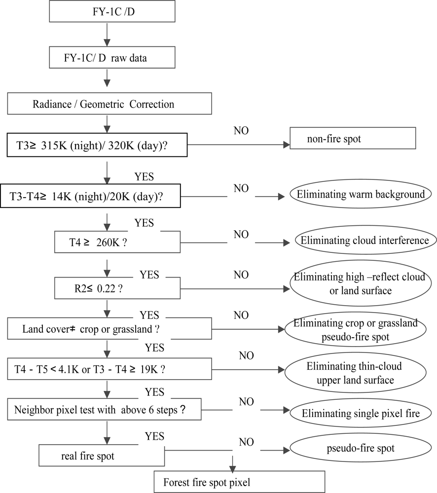
2.2. The Chinese Polar Orbiting Meteorological Satellite FY-1C/1D
2.3. The Chinese Geostationary Meteorological Satellite FY-2
2.4. The CBERS: China-Brazil Earth Resources Satellite
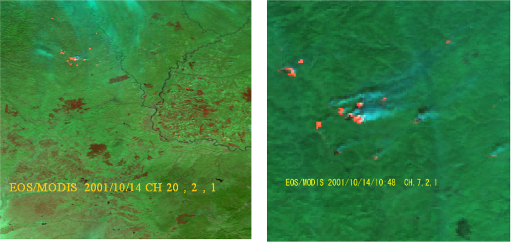
2.5. The EOS/MODIS Satellite
2.6. The ESA ENVISAT Satellite
3. New Techniques Used in Detection of Forest Fire in China
3.1. Estimation of Sub-Pixel Fire Burned Areas and Temperature
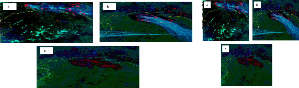
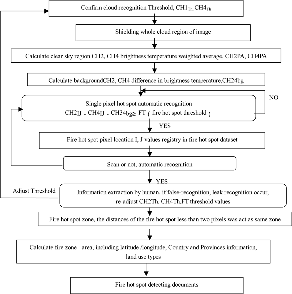
3.2. Auto-Identification of Forest Fire Hot Spots
3.3. Establishment of a New Fire Detection Channel Selection from Fire Experiment
3.4. A New Algorithm for Fire Burned Areas Identification
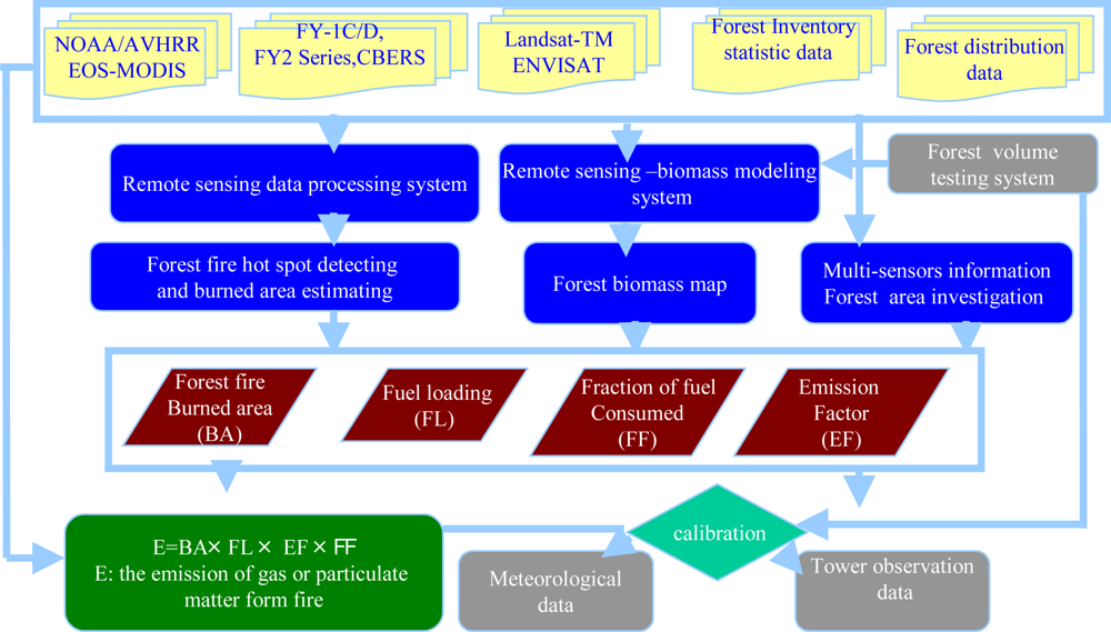
4. Forest Fire Emissions Estimation in China
4.1. Forest Biomass Simulation Based on BEPS Model and Satellite data
4.2. Quantifying Emission of Forest Fire in China using Satellite Data and Emission Model
5. Forest Fire Risk Prediction in China
5.1. The Fire Spread Behavior Model
5.2. Forest Fire Risk Prediction Based on Satellite Data and GIS
5.3. Forest Fuel Moisture Content Estimation Model
5.4. Comparison between the Fire Risk Rating Systems in China and Those Used in Other Regions
6. Conclusions and Remarks
Acknowledgments
References
- Costanza, R; Groot, R. The value of the world's ecosystem services and natural capital. Nature 1997, 387, 253–260. [Google Scholar]
- Food and Agriculture Organization (FAO). Global Forest Resources Assessment 2005; FAO: Rome, Italy, 2005. [Google Scholar]
- Houghton, RA. Release of carbon to the atmosphere from degradation of forests in tropical Asia. Can. J. Forest Res 1991, 21, 132–142. [Google Scholar]
- Aurelia, BM. A hedonic valuation of urban green areas. Landsc. Urban Plann 2003, 66, 35–41. [Google Scholar]
- Chuvieco, E; Congalton, RG. Application of remote sensing and geographic information system to forest fire hazard mapping. Rem. Sens. Environ 1989, 29, 147–159. [Google Scholar]
- Rajeev, KJ; Saumitra, M; Kumaran, DR; Saxena, R. Forest fire risk zone mapping from satellite imagery and GIS. Int. J. Appl. Earth Obs 2002, 4, 1–10. [Google Scholar]
- Li, Z; Jin, J; Gong, P; Pu, RL. Use of satellite remote sensing data for modeling carbon emissions from fires: A perspective in North America. In Earth Science Satellite Remote Sensing, Science and Instruments; Qu, JJ, Gao, W, Kafatos, M, Murphy, RE, Salomonson, VV, Eds.; Tsinghua University Press and Springer: Beijing, China, 2006; Volume 1, pp. 337–362. [Google Scholar]
- Cochrane, MA; Laurance, WF. Synergisms among fires, land use, and climate change in the Amazon. AMBIO 2008, 37, 522–527. [Google Scholar]
- Li, NY; Yuan, JH. Chinese forestry construction under climatic change background. Prot. Forest Sci. Technol 2011, 1, 5–7. [Google Scholar]
- Fan, SH; Zeng, XW; Zhang, Q. Forest resources and environment in China. Chin. Forest. Sci. Technol 2004, 4, 88–95. [Google Scholar]
- Zhou, GS; Lu, Q. The Meteorology and Forest and Grassland Fire Disaster; Meteorological Press: Beijing, China, 2009. [Google Scholar]
- Shao, JZ. The destruction of the forest fire to ecosystem and ecological fireproofing countermeasures. Fire Prev. Prod. Inform 2000, 12, 21–22. [Google Scholar]
- Xu, AJ; Li, QQ; Fang, LM; Wu, DS. Study on model about forest fire forecast and prediction based on GIS. J. Zhejiang Forest. Coll 2003, 20, 285–288. [Google Scholar]
- Cahoon, DR; Stocks, BJ; Levine, JS; Cofer, WR; Pierson, JM. Satellite analysis of the severe 1987 forest fires in northern China and southeastern Siberia. J. Geophys. Res 1994, 99, 18627–18638. [Google Scholar]
- Kong, FH; Li, XZ; Zhao, SL; Yin, HW. Research advance in forest restoration on the burned blanks. J. Forest. Res 2003, 14, 180–184. [Google Scholar]
- Qin, XL; Li, ZY; Tian, XY; Pang, Y; Casanova, JL; Calle, A; Li, ZY; Goldammer, J. Progresses of Forest Fire Monitoring Demonstration by Remote Sensing in China. Proceedings of 2006 Dragon Lijiang Symposium, Lijiang, China, 10–14 July 2006.
- Tian, XR; Shu, LF; Fu, J. The affection of ENSO and macula on forest fires in China. World Forest. Res 2003, 16, 22–25. [Google Scholar]
- Prins, E; Feltz, J; Menzel, W; Ward, D. An overview of GOES-8 diurnal fire and smoke results for SCAR-B and 1995 fire season in South America. J. Geophys. Res 1998, 103, 31821–31835. [Google Scholar]
- Li, Z; Nadon, S; Cihlar, J. Satellite-based detection of Canadian boreal forest fires: Development and application of the algorithm. Int. J. Rem. Sens 2000, 21, 3057–3069. [Google Scholar]
- Li, Z; Nadon, S; Cihlar, J; Stocks, BJ. Satellite mapping of Canadian boreal forest fires: Evaluation and comparison. Int. J. Rem. Sens 2000, 21, 3071–3082. [Google Scholar]
- Justice, CO; Giglio, L; Korontzi, S; Owens, J; Morisette, JT; Roy, D; Descloitres, J. The MODIS fire products. Rem. Sens. Environ 2002, 83, 244–262. [Google Scholar]
- Giglio, L; Descloitres, J; Justice, CO; Kaufman, YJ. An enhanced contextual fire detection algorithm for MODIS. Rem. Sens. Environ 2003, 87, 273–282. [Google Scholar]
- Morisette, JT; Giglio, L; Csiszar, I; Setzer, A; Schroeder, W; Morton, D; Justice, CO. Validation of MODIS active fire detection products derived from two algorithms. Earth Interact 2005, 9, 1–25. [Google Scholar]
- Csiszar, I; Morisette, J; Giglio, L. Validation of active fire detection from moderate resolution satellite sensors: The MODIS example in Northern Eurasia. IEEE Trans. Geosci. Rem. Sens 2006, 44, 1757–1764. [Google Scholar]
- Patterson, MW; Yool, SR. Mapping fire-induced vegetation mortality using Landsat Thematic Mapper data: A comparison of linear transformation techniques. Rem. Sens. Environ 1998, 65, 132–142. [Google Scholar]
- Van Wagtendonk, JW; Root, RR; Key, C. Comparison of AVIRIS Landsat ETM+ detection capabilities for burn severity. Rem. Sens. Environ 2004, 92, 397–408. [Google Scholar]
- Epting, J; Verbyla, D; Sorbel, B. Evaluation of remotely sensed indices for assessing burn severity in interior Alaska using Landsat TM and ETM+. Rem. Sens. Environ 2005, 96, 328–339. [Google Scholar]
- Hoy, EE; French, NHF; Turetsky, MR; Trigg, SN; Kasischke, ES. Evaluating the potential of Landsat TM/ETM+ imagery for assessing fire severity in Alaskan black spruce forests. Int. J. Wildland Fire 2008, 17, 500–514. [Google Scholar]
- Zhang, JH; Liu, C. Monitoring vegetation fires using satellite data in and around China. Proceedings of EastFIRE Conference, 11–13 May 2005; Geroge Mason University: Farifax, VA, USA.
- Setzer, A; Pereira, M. Amazonia biomass burnings in 1987 and an estimate of their tropospheric emissions. Ambio 1991, 20, 19–22. [Google Scholar]
- Al-Saadi, J; Soja, A; Pierce, RB; Szykman, J; Wiedinmyer, C; Emmons, L; Kondragunta, S; Zhang, X; Kittaka, C; Schaack, T; et al. Intercomparison of near-real-time biomass burning emissions estimates constrained by satellite fire data. J. Appl. Rem. Sens 2008, 2, 021504:1–021504:24. [Google Scholar]
- Patra, PK; Ishizawa, M; Maksyutov, S; Nakazawa, T; Inoue, G. Role of biomass burning and climate anomalies for land-atmosphere carbon fluxes based on inverse modeling of atmospheric CO2. Global Biogeochem. Cy 2005, 19, GB3005:1–GB3005:15. [Google Scholar]
- Boschetti, L; Roy, DP. Defining a fire year for reporting and analysis of global interannual fire variability. J. Geophys. Res 2008, 113, G03020:1–G03020:11. [Google Scholar]
- Fang, JY; Chen, AP; Peng, CH; Zhao, SQ; Ci, LJ. Changes in forest biomass carbon storage in China between 1949 and 1998. Science 2001, 22, 2320–2322. [Google Scholar]
- Tian, XR; Gao, CD; Shu, LF; Wang, MY; Yang, XH. Estimation of direct carbon emissions from Chinese forest fires. Forest. Sci. Technol 2004, 3, 87–92. [Google Scholar]
- Lü, AF; Tian, HQ; Liu, ML; Liu, JY; Melillo, JM. Spatial and temporal patterns of carbon emissions from forest fires in China from 1950 to 2000. J. Geophys. Res 2006, 111, D05313:1–D05313:12. [Google Scholar]
- Jaiswal, RK; Mukherjee, S; Raju, DK; Saxena, R. Forest fire risk zone mapping from satellite imagery and GIS. Int. J. Appl. Earth Obs 2002, 4, 1–10. [Google Scholar]
- Dong, CH. Interpretation Handbook about Meteorological Satellite Operational Products; Meteorological Press: Beijing, China, 1999. [Google Scholar]
- Zhang, WJ; Xu, JM; Dong, CH; Yang, J. China's current and future meteorological satellite systems. In Earth Science Satellite Remote Sensing, Science and Instruments; Qu, JJ, Gao, W, Kafatos, M, Murphy, RE, Salomonson, VV, Eds.; Tsinghua University Press and Springer: Beijing, China, 2006; Volume 1, pp. 393–413. [Google Scholar]
- Guo, JN. CBERS & Data Applications. Proceedings of 2006 Dragon Lijiang Symposium, Lijiang, China, 10–14 July 2006.
- Li, Y; Wang, E. Establishment of the environmental information system based on the CBERS satellite remote sensing imagery. Environ. Monit. Manag. Technol 2006, 18, 39–41. [Google Scholar]
- Kaufman, YJ; Justice, CO; Flynn, LP; Kendall, JD; Prins, EM; Giglio, L; Ward, DE; Menzel, P; Setzer, AW. Potential global fire monitoring from EOS-MODIS. J. Geophys. Res 1998, 103, 32215–32238. [Google Scholar]
- Giglio, L; van der Werf, GR; Randerson, JT; Collatz, GJ; Kasibhatla, P. Global estimation of burned area using MODIS active fire observations. Atmos. Chem. Phys 2006, 6, 957–974. [Google Scholar]
- Schroeder, W; Prins, E; Giglio, L; Csiszar, I; Schimdt, C; Morisette, J; Morton, D. Validation of GOES and MODIS active fire detection products using ASTER and ETM+ data. Rem. Sens. Environ 2008, 112, 2711–2726. [Google Scholar]
- Roy, DP; Boschetti, L; Justice, CO; Ju, J. The collection 5 MODIS burned area product—global evaluation by comparison with the MODIS active fire product. Rem. Sens. Environ 2008, 112, 3690–3707. [Google Scholar]
- Davies, DK; Ilavajhala, S; Wong, MM; Justice, CO. Fire information for resource management system: Archiving and distributing MODIS active fire data. IEEE Trans. Geosci. Rem. Sens 2009, 47, 72–79. [Google Scholar]
- Takahata, C; Amin, R; Sarma, P; Banerjee, G; Oliver, W; Fa, J. Remotely-sensed active fire data for protected area management: Eight-year patterns in the Manas National Park, India. Environ. Manag 2010, 45, 414–423. [Google Scholar]
- Liang, Y. Monitoring the forest fire by using EOS/MODIS data. Rem. Sens. Technol. Appl 2002, 17, 310–312. [Google Scholar]
- Qin, XL; Yi, HR. A method to identify forest fire based on MODIS data. Fire Safety Sci 2004, 13, 83–89. [Google Scholar]
- Liu, LM; Yan, JJ. Fire detection based on EOS MODIS data. Geomat. Inform. Sci. Wuhan Univer 2004, 29, 55–58. [Google Scholar]
- Zhang, SY; Jing, YG. Study on application of EOS-MODIS data to forest fire monitoring. J. Catastrophol 2004, 19, 62–58. [Google Scholar]
- Zhou, XC; Wang, XQ; Xiang, TH; Jiang, H. Validation analysis of the algorithm for identifying forest fire based on MODIS data. Fire Safety Sci 2006, 15, 31–38. [Google Scholar]
- Zhou, M; Guo, GM; Song, DM; Wang, GS. A discussion about fire monitoring with MODIS data. J. Arid Land Resour. Environ 2006, 20, 180–183. [Google Scholar]
- European Space Agency (ESA). ENVISAT Product Handbooks; ESA: Paris, France, 2004. [Google Scholar]
- Huang, S; Siegert, F. ENVISAT multi-sensor data for fire monitoring and impact assessment. Int. J. Rem. Sens 2004, 25, 4411–4416. [Google Scholar]
- Badarinath, KVS; Lathaand, KM; Chand, TRK. Forest fires monitoring using Envisat-Aatsr data. J. Indian Soc. Rem. Sens 2004, 32, 317–322. [Google Scholar]
- Calle, A; Casanova, JL; Moclán, C. Detection and Monitoring of Forest Fires in China through the ENVISAT-AATSR Sensor. Proceedings of the 5th International Workshop on Remote Sensing and GIS Applications to Forest Fire Management: Fire Effects Assessment, Zaragoza, Spain, 16–18 June 2005; De la Riva, J, Pérez-Cabello, F, Chuvieco, E, Eds.; pp. 149–152.
- Qin, XL; Li, ZY; Yi, HR. Studying on burned scar mapping using ENVISat-MERIS data. Rem. Sens. Technol. Appl 2008, 23, 1–7. [Google Scholar]
- Liu, C; Li, YJ; Zhao, CH; Yan, H; Zhao, HM. The method of evaluating sub-pixel size and temperature of fire spot in AVHRR data. J. Appl. Meteorol. Sci 2004, 15, 273–280. [Google Scholar]
- Wen, GY; Hou, XM; Chen, HH. The application of artificial nervous net to forecasting forest fire. J. Biomath 2001, 16, 225–228. [Google Scholar]
- Liang, YT; Hu, JL; Xie, P; Liu, LM. Auto-identifying forest fire-points in meteorological satellite images based on neural network. J. Appl. Meteorol. Sci 2003, 14, 708–714. [Google Scholar]
- Li, ZQ; Khananian, A; Fraser, RH; Cihlar, J. Automatic detection of fire smoke using artificial neural networks and threshold approaches applied to AVHRR imagery. IEEE Trans. Geosci. Rem. Sens 2001, 39, 18659–18670. [Google Scholar]
- Zhang, DY; Han, SZ; Zhao, JH; Zhang, Z; Qu, CZ; Ke, YW; Chen, X. Image based forest fire detection using dynamic characteristics with artificial neural networks. Proceedings of International Joint Conference on Artificial Intelligence, Hainan Island, China, 25–26 April 2009; pp. 290–293.
- Maeda, EE; Formaggio, AR; Shimabukuro, YE; Arcoverde, GFB; Hansen, MC. Predicting forest fire in the Brazilian Amazon using MODIS imagery and artificial neural networks. Int. J. Appl. Earth Obs 2009, 11, 265–272. [Google Scholar]
- Sun, H; Rong, ZG; Liu, C; Liu, JJ; Zhang, Y; Zhang, P; Wang, XL; Gao, W. Spectral Characteristics of Infrared Radiation from Forest Fires. In Remote Sensing and Modeling of Ecosystems for Sustainability, 3nd Edition; Gao, W, Ustin, SL, Eds.; Society of Photo-Optical Instrumentation Engineers: Washington, DC, USA, 2006; pp. 1–9. [Google Scholar]
- Hao, WM; Ward, DW; Olbu, G; Baker, SP. Emissions of CO2, CO, and hydrocarbons from fires in diverse African savanna ecosystems. J. Geophys. Res 1996, 101, 23577–23584. [Google Scholar]
- Ressl, R; Lopez, G; Cruz, I; Colditz, RR; Schmidt, M; Ressl, S; Jiménez, R. Operational active fire mapping and burned area identification applicable to Mexican nature protection areas using MODIS and NOAA-AVHRR direct readout data. Rem. Sens. Environ 2009, 113, 1113–1126. [Google Scholar]
- Pinty, B; Verstraete, MM. GEMI: A non-linear index to monitor global vegetation from satellites. Vegetation 1992, 101, 15–20. [Google Scholar]
- Stroppiana, D; Pinnock, S; Pereira, JMC; Gregorie, JM. Radiometric analysis of SPOT-VAGETATION images for burned area detection in Northern Australia. Rem. Sens. Environ 2002, 81, 21–37. [Google Scholar]
- Barbosa, PM; Gregoire, JM; Pereira, JMC. An algorithm for extracting burned Areas from time series of AVHRR GAC data applied at a continental scale. Rem. Sens. Environ 1999, 69, 253–263. [Google Scholar]
- Fraser, RH; Li, Z; Landry, R. SPOT vegetation for characterizing boreal forest fires. Int. J. Rem. Sens 2000, 21, 3525–3532. [Google Scholar]
- Garcia, M; Chuvieco, E. Assessment of potential of SAC-C/MMRS imagery for mapping burned areas in Spain. Rem. Sens. Environ 2004, 92, 414–423. [Google Scholar]
- Key, CH; Benson, NC. Landscape Assessment: Remote Sensing of Severity, the Normalized Burn Ratio. In FIREMON: Fire Effects Monitoring and Inventory System; General Technical Report, RMRSGTR-164-CD: LA1-LA51; Ogden, UT, Lutes, DC, Eds.; USDA Forest Service, Rocky Mountain Research Station: Fort Collins, CO, USA, 2005. [Google Scholar]
- Tan, MY; Chen, ZX; Cao, X; Chen, J; Yang, W; Gu, ZH. Burn scar mapping in steppe using MODIS data. J. Rem. Sens 2007, 11, 340–349. [Google Scholar]
- Dwyer, E; Gregoire, JM; Malingreau, JP. A global analysis of vegetation fires using satellite images: Spatial and temporal dynamics. AMBIO 1998, 27, 175–181. [Google Scholar]
- Eric, SK; Stocks, BJ. Fire, Climate Change and Carbon Cycling in the Boreal Forest; Spriger-Verlag: New York, NY, USA, 2000. [Google Scholar]
- Langenfelds, RL; Francey, RJ; Pak, BC; Steele, LP; Lioyd, SJ; Trudinger, CM; Allison, CE. Interannual growth rate variations of atmospheric CO2 and its δ13C, H2, CH4, and CO between 1992 and 1999 linked to biomass burning. Global Biogeochem. Cy 2002, 16, 1048. [Google Scholar]
- Schimel, D; Baker, D. The wildfire factor. Nature 2002, 420, 29–30. [Google Scholar]
- Liu, YQ. Variability of wildland fire emissions across the contiguous United States. Atmos. Environ 2004, 38, 3489–3499. [Google Scholar]
- Brown, S. Biomass of tropical forests: A new estimate based on forest volumes. Science 1984, 223, 1290–1293. [Google Scholar]
- Liu, JY; Chen, JM; Cihlar, J; Park, WM. A process-based boreal ecosystem productivity simulator using remote sensing inputs. Rem. Sens. Environ 1997, 62, 158–175. [Google Scholar]
- Cramer, W; Kicklighter, DW; Bondeau, AL; Moore, B, III; Churkina, G; Nemry, B; Ruimy, A; Schloss, AL; the participants of the Potsdam NPP Model Intercomparison. Comparing global models of terrestrial net primary productivity (NPP), overview and key results. Global Change Biol 1999, 5(Suppl 1), 1–15. [Google Scholar]
- Tian, HQ; Melillo, JM; Kicklighter, DW; McGuire, AD; Helfrich, J. The sensitivity of terrestrial carbon storage to historical climate variability and atmospheric CO2 in the United States. Tellus 1999, 51, 414–452. [Google Scholar]
- Amiro, BD; Chen, JM; Liu, J. Net primary productivity following forest fire for Canadian ecoregions. Can. J. Forest Res 2000, 30, 939–947. [Google Scholar]
- Running, SW; Coughlan, JC. A general model of forest ecosystem processes for regional applications, I. Hydrological balance, canopy gas exchange and primary production processes. Ecol. Model 1988, 42, 125–154. [Google Scholar]
- Wang, PJ; Sun, R; Hua, J; Zhua, Q; Zhou, Y; Li, L; Chen, JM. Measurements and simulation of forest leaf area index and net primary productivity in northern China. J. Environ. Manag 2007, 85, 607–615. [Google Scholar]
- Wang, PJ; Xie, DH; Zhang, JH; Zhu, QJ; Chen, JM. Spatial scaling of net primary productivity based on process model in Changbai Mountain Natural Reserve. Acta Ecologica Sinca 2007, 27, 3215–3224. [Google Scholar]
- Feng, X; Liu, G; Chen, JM; Chen, M; Liu, J; Ju, WM; Sun, R; Zhou, W. Net primary productivity of China's terrestrial ecosystems from a process model driven by remote sensing. J. Environ. Manag 2007, 85, 563–573. [Google Scholar]
- Zhang, N; Yu, ZL; Yu, GR; Wu, JG. Scaling up ecosystem productivity from patch to landscape: A case study of Changbai mountain nature reserve, China. Landsc. Ecol 2007, 22, 303–315. [Google Scholar]
- Jiang, H; Wang, XQ; Sun, WJ; Wang, QM. Simulation and Spatial-Temporal Analysis of Forest Net Primary Productivity in Fujian Province, China. In Digital Earth Summit on Geoinformatics 2008; Ehlers, M, Behncke, K, Gerstengarbe, F-W, Hillen, F, Koppers, L, Stroink, L, Eds.; Wichmann: Heidelberg, Germany, 2008; p. 290. [Google Scholar]
- Zhang, HH; Liu, GH; Feng, XF. A process model for simulating net primary productivity (NPP) based on the interaction of water-heat process and nitrogen: A case study in Lantsang valley. J. Forest. Res 2011, 22, 93–97. [Google Scholar]
- Liu, JY; Tian, HQ; Liu, ML; Zhuang, DF; Melillo, JM; Zhuang, Z. China's changing landscape during the 1990s: Large-scale land transformations estimated with satellite data. Geophys. Res. Lett 2005, 32, L02405:1–L02405:5. [Google Scholar]
- Wang, CK; Gower, ST; Wang, YH; Zhao, HX; Yan, P; Bond-Lamberty, BP. The influence of fire on carbon distribution and net primary production of boreal Larix gmelinii forests in north-eastern China. Global Change Biol 2001, 7, 719–730. [Google Scholar]
- Zhu, QJ; Rong, TZ; Sun, R. A case study on fractal simulation of forest fire spread. Sci. China 2000, 43, 104–112. [Google Scholar]
- Malamud, BD; Morein, B; Turcotte, DL. Forest fires: An example of self-organized critical behavior. Science 1998, 281, 1840–1842. [Google Scholar]
- Song, WG; Fan, WC; Wang, BG. Self-organized criticality of forest fires in China. Chin. Sci. Bull 2001, 46, 1134–1137. [Google Scholar]
- Xu, D; Dai, LM; Shao, GF; Tang, L; Wang, H. Forest fire risk zone mapping from satellite images and GIS for Baihe Forestry Bureau, Jilin, China. J. Forest. Res 2005, 13, 169–174. [Google Scholar]
- Xu, D; Shao, GF; Dai, LM; Hao, ZQ; Tang, L; Wang, H. Mapping forest fire risk zones with spatial data and principal component analysis. Sci. China (Series E) 2006, 49(Suppl I), 140–149. [Google Scholar]
- Penuelas, J; Filella, I; Biel, C; Serrano, L; Save, R. The reflectance at the 950–970 nm region as an indicator of plant water status. Int. J. Rem. Sens 1993, 14, 1887–1905. [Google Scholar]
- Carter, GA. Primary and secondary effects of water content of the spectral reflectance of leaves. Am. J. Bot 1991, 78, 919–924. [Google Scholar]
- Gao, BC. NDWI—A normalized difference water index for remote sensing of vegetation liquid water from space. Rem. Sens. Environ 1996, 58, 257–266. [Google Scholar]
- Wang, LL; Qu, J; Hao, XJ. Forest fire detection using the normalized multi-band drought index (NMDI) with satellite measurements. Agr. Forest Meteorol 2008, 148, 1767–1776. [Google Scholar]
- Roberts, DA; Green, RO; Adams, JB. Temporal and spatial patterns in vegetation and atmospheric properties from AVIRIS. Rem. Sens. Environ 1997, 62, 223–234. [Google Scholar]
- Ustin, SL; Roberts, DA; Pinzon, J; Jaquemoud, S; Gardner, M; Scheer, G; Castaeda, CM; Palacios-Orueta, A. Estimating canopy water content of chaparral shrubs using optical methods. Rem. Sens. Environ 1998, 65, 280–291. [Google Scholar]
- Zhang, JH; Xu, Y; Yao, FM; Wang, PJ; Guo, WJ; Li, L; Yang, LM. Advances in estimation methods of vegetation water content based on optical remote sensing techniques. Sci. China (Series E) 2010, 53, 1159–1167. [Google Scholar]
- Matthews, S. A comparison of fire danger rating systems for use in forests. Austr. Meteorol. Oceano. J 2009, 58, 41–48. [Google Scholar]
- Bradshaw, LS; Deeming, JE; Burgan, RE; Cohen, JD. The 1978 National Fire-Danger Rating System: Technical Documentation; USDA Forest Service: Washington, DC, USA, 1984. [Google Scholar]
- Robert, EB. Revisions to the 1978 National Fire Danger Rating System; USDA Forest Service: Washington, DC, USA, 1988. [Google Scholar]
- Jack, DC; John, ED. The National Fire Danger Rating System: Basic Equations; USDA Forest Service: Washington, DC, USA, 2002. [Google Scholar]
- Large Fire Potential and Fire Potential Indexes. Available online: http://www.wfas.net/index.php/large-fire-potential-and-fire-potential-indexes-external-products-107 (accessed on 31 March 2011).
- Stocks, BJ; Lawson, BD; Alexander, ME; Van Wagner, CE; McAlpine, RS; Lynham, TJ; Dube, DE. The Canadian forest fire danger rating system: An overview. Forest. Chron 1989, 65, 450–457. [Google Scholar]
- Taylor, SW; Alexander, ME. Science, technology, and human factors in fire danger rating: the Canadian experience. Int. J. Wildland Fire 2006, 15, 121–135. [Google Scholar]
- Wang, XX; Liu, ZZ; Wu, SY. National Forest Fire Risk Weather Danger (LY/T1172295); Standards Press of China: Beijing, China, 1996. [Google Scholar]
- Yi, H; Ji, P; Qin, X. Study on forest fire danger forecast system and its operation in China. Scientia Silvae Sinicae 2004, 40, 203–207. [Google Scholar]
- Qin, XL; Zhang, H; Li, ZY; Yi, HR. Forecasting methodology of national-level forest fire risk rating. Rem. Sens. Technol. Appl 2008, 23, 500–504. [Google Scholar]
- Xiong, WC; Wei, B; Sun, ZP; Shen, WM; You, DA. Australian forest fire disaster monitoring based on CCD and IRS data of HJ-1-B. Rem. Sens. Technol. Appl 2010, 25, 178–182. [Google Scholar]
- Guo, CH; Qi, XY; Gong, YL; Zhu, LY. Study on the technology and method of forest fire monitoring by using HJ satellite images. Rem. Sens. Inform 2010, 4, 85–99. [Google Scholar]
- Li, JG; Gu, XF; Yu, T; Wei, B. Detection of Australian southeast forest fire using HJ satellite. J. Beijing Univer. Aeronaut. Astronaut 2010, 36, 1221–1224. [Google Scholar]
- Liu, YQ. Atmospheric response and feedback to radiative forcing from biomass burning in tropical south America. Agr. Forest Meteorol 2005, 133, 40–53. [Google Scholar]


| Channel | Wavelength (μm) | Resolution (km) | Dynamic range | Detecting sensitivity | Fire detection |
|---|---|---|---|---|---|
| 1 | 0.58–0.68 | 1.1 | 0–90% | S/N ≥ 3 (ρ = 0.5%) | Burnt area |
| 2 | 0.84–0.89 | 1.1 | 0–90% | S/N ≥ 3 (ρ = 0.5%) | Burnt area |
| 3 | 3.55–3.95 | 1.1 | 190–340 K | NEΔT ≤ 0.4 K (300 K) | Hot-spot |
| 4 | 10.3–11.3 | 1.1 | 190–330 K | NEΔT ≤ 0.22 K (300 K) | Hot-spot |
| 5 | 11.5–12.5 | 1.1 | 190–330 K | NEΔT ≤ 0.22 K (300 K) | Burnt area |
| Channel | Wavelength (μm) | Resolution (km) | Dynamic range | Temperature resolution (K) | S/N | Primary use |
|---|---|---|---|---|---|---|
| 1 | 0.5–0.9 | 1.25 | 0–98% | 0.5ρ = 2.5% 95ρ = 95% | Burnt area | |
| 2 | 3.5–4.0 | 5 | 180–330 K | 0.6–0.5 | Hot-spot | |
| 3 | 6.3–7.6 | 5 | 180–280 K | 0.5–0.3 | Water vapor | |
| 4 | 10.3–11.3 | 5 | 180–330 K | 0.4–0.2 | Hot-spot | |
| 5 | 11.5–12.5 | 5 | 180–330 K | 0.4–0.2 | Burnt area |
| Payload | CCD | IRMSS | WFI |
|---|---|---|---|
| Sensor Type | Push-broom | Electro-mechanic | Push-broom |
| Visible and near infrared bands (μm) | 1: 0.45–0.52 2: 0.52–0.59 3: 0.63–0.69 4: 0.77–0.89 5: 0.51–0.73 | 6: 0.50–0.90 | 10: 0.63–0.69 11: 0.77–0.89 |
| Shortwave infrared bands (μm) | 7: 1.55–1.75 8: 2.08–2.35 | ||
| Thermal infrared bands (μm) | 9: 10.4–12.5 | ||
| Resolution (m) | 19.5 | Band 6–8: 78 Band 9: 156 | 258 |
| View angle | 8.32° | 8.80° | 59.6° |
| Swath wide (km) | 113 | 119.5 | 890 |
© 2011 by the authors; licensee MDPI, Basel, Switzerland. This article is an open-access article distributed under the terms and conditions of the Creative Commons Attribution license (http://creativecommons.org/licenses/by/3.0/).
Share and Cite
Zhang, J.-H.; Yao, F.-M.; Liu, C.; Yang, L.-M.; Boken, V.K. Detection, Emission Estimation and Risk Prediction of Forest Fires in China Using Satellite Sensors and Simulation Models in the Past Three Decades—An Overview. Int. J. Environ. Res. Public Health 2011, 8, 3156-3178. https://0-doi-org.brum.beds.ac.uk/10.3390/ijerph8083156
Zhang J-H, Yao F-M, Liu C, Yang L-M, Boken VK. Detection, Emission Estimation and Risk Prediction of Forest Fires in China Using Satellite Sensors and Simulation Models in the Past Three Decades—An Overview. International Journal of Environmental Research and Public Health. 2011; 8(8):3156-3178. https://0-doi-org.brum.beds.ac.uk/10.3390/ijerph8083156
Chicago/Turabian StyleZhang, Jia-Hua, Feng-Mei Yao, Cheng Liu, Li-Min Yang, and Vijendra K. Boken. 2011. "Detection, Emission Estimation and Risk Prediction of Forest Fires in China Using Satellite Sensors and Simulation Models in the Past Three Decades—An Overview" International Journal of Environmental Research and Public Health 8, no. 8: 3156-3178. https://0-doi-org.brum.beds.ac.uk/10.3390/ijerph8083156