Article

Do Sandy Grasslands along the Danube in the Carpathian Basin Preserve the Memory of Forest-Steppes?

1
Institute of Crop Production Sciences, Szent István University, Páter Károly utca 1, H-2100 Gödöllő, Hungary
2
Institute of Nature Resource Conservation, Szent István University, Páter Károly utca 1, H-2100 Gödöllő, Hungary
3
Doctoral School of Environmental Sciences, Szent István University, Páter Károly utca 1, H-2100 Gödöllő, Hungary
4
Institute for Nuclear Research, Isotope Climatology and Environmental Research Centre, Bem tér 18/c, H-4026 Debrecen, Hungary
5
Faculty of Agricultural and Environmental Sciences, Szent István University, Páter Károly utca 1, H-2100 Gödöllő, Hungary
6
Institute of Environmental Sciences, Szent István University, Páter Károly utca 1, H-2100 Gödöllő, Hungary
*
Author to whom correspondence should be addressed.
Submission received: 16 November 2020 / Revised: 12 January 2021 / Accepted: 19 January 2021 / Published: 20 January 2021
(This article belongs to the Special Issue Spatial Heterogeneity of Forest-Steppes)

Abstract

:
Research highlights: In the present survey we examined the sandy grasslands appearing in the steppe-forest-steppe vegetation in the central part of the Carpathian Basin along the Danube. Background and objectives: We aimed to answer the following questions: Is it possible to build a picture of the past form of the vegetation through the examination of these vegetation units based on dominant grass taxa? Is Festuca wagneri an element of open grasslands or steppes? According to our hypothesis, these surveys can help reveal the original or secondary woody, shrubby patches through clarifying dominant taxa. Materials and Methods: We studied the grasslands in terms of coenology, putting great emphasis on the dominant Festuca taxa. Based on our preliminary surveys and literature, three vegetation types can be separated based on one single dominant Festuca taxon in each. The survey was conducted in four different locations in the Carpathian Basin. The cover of dominant grass species was used as an indicator value. The pedological background was also examined. Results: F. vaginata grassland is an open vegetation type based on its coenosystematic composition and ecological values. It grows in very weakly developed calcareous soil with sandy texture, with its lowest and highest organic carbon content ranging from 0.2% to 11.3% (0.2%), and the highest carbonate content (11.3%). Where the grasslands were disturbed, F. pseudovaginata and the recently discovered F. tomanii appeared. These taxa were also found in forest patches. The soil under F. pseudovaginata was more developed, in the surface horizon with higher organic carbon content (1.1%) and lower carbonate content (6.9%). The soil profile under F. wagneri developed the most, as the presence of deep and humus rich soil material from deflation and degradation showed. Conclusions: the dominant Festuca taxa of these vegetation types are good indicators of the changes in the vegetation and their ecological background.

1. Introduction

We analyzed the sandy vegetation along the Danube in the central area of the Carpathian Basin, notably the calcareous sandy grasslands, which neighbor forest-steppe patches. The Pannonian–Pontic environmental zone (PAN) of the Carpathian basin, the Middle and Lower-Danube Plains and the Black-Sea. This area within characterized by natural forest-steppe and steppe vegetation [1,2,3]. The western borders of the Palaearctic steppe zone stretches across Eastern Europe, with high coverages of steppe and steppe-like grasslands in Bulgaria, Hungary, Moldova and Ukraine. The most important grassland types and subtypes in Eastern Europe [4] are the steppe grasslands (Festuco-Brometea: Festucetalia valesiacae), which are primary grasslands in the Eastern European region associated with the steppe and forest steppe zones. They are typically distributed in lowlands and at the foothills, and characterized by the dominance of Festuca and Stipa species.
The origin and history of the vegetation in the Pannonian zone are not always clear [5]. In the last centuries the original zonal appearance of the vegetation went through significant changes and became mosaic-like [6]. In the Carpathian Basin the zonal arrangement of the soil types and climate disbands completely, giving the place a mosaic-like landscape [6,7]. As a result, a mosaic-like vegetation types appeared. In areas with calcareous soil in the central area of the Carpathian Basin the environmental factors are also mosaic-like [8,9,10]. According to [11], in the sandy areas of the Danube-Tisza Interfluve, different vegetation patches are formed along environmental gradients. These gradients can be physical parameters, such as soil moisture, soil structure, exposure or temperature [12,13,14].
According to [15], in natural forest steppe transitions, trees can have a major effect on herb vegetation composition. In the understory of the forest and grove patches the species composition is different but instead of being a refuge of forest-specialized herbs other grassland-specialized species appear, contradicting the stress-gradient hypothesis [16,17], which states that competitive partners can change to facilitative ones at higher stress levels.
The regeneration potential of steppes is considerably lower than that of wet meadows, so mowing alone or intensive grazing is not effective in maintaining the diversity of the vegetation, though its more effective than abandoning it [18,19]; complex methods of low-level grazing and mowing should be used [20]. Ref. [21] also mention that richness of the soil can be a negative factor in the regeneration of arid steppes, since on more fertile soils the ruderal competitors make the natural recovery of specialist species nearly impossible.
According to [22,23], 45% of woody cover can be considered to be a threshold level, above which grassland specialist herbs give way to forest-related ones. They state that forest-steppe mosaics, closed forests and open grasslands also form a mosaic on higher altitudes, which also has to be taken into consideration when the management and conversation of these complex habitats are planned.
Refs. [24,25] summed up the main features and characteristics of Eurasian forest-steppes in an extensive review in which they describe the highly diverse fine-scale grassland-forest mosaics in the Carpathian basin as forest-steppes with characteristic species (among others) such as Quercus spp., Acer tataricum, Populus alba and herbs like Chrispopgon gryllus, Festuca vaginata, F. rupicola, F. valesiaca, Stipa spp. and Astragalus spp.
In the past few centuries, significant changes occurred in the relationship of forests and grasslands between the Danube and the Tisza. Grasslands appeared to replace forests and some swamps disappeared [26,27]. In the contact zones or rather, according to the present results, in places once covered in forests, open sandy surfaces formed then became inhabited by vegetation in a relatively short period of time [21,28,29,30]. At the same time, effects of human interventions can be detected long after they ended [31]. In places once covered in forests succession begins as a natural way of the regeneration of vegetation [32,33,34,35,36].
The soil-vegetation relationship in the sandy regions of the Danube–Tisza Interfluve was described and assessed by [37,38]. Ref. [39] also performed a botanical study of the Juniperetum of the Bugac area, in which he characterized the different vegetation types, compiled flora descriptions supplemented with coenological data and provided a guideline for the evaluation of the location of the vegetation types of the Hungarian Great Plain. Járó [40] (1974) summarized the types of habitats of the Danube–Tisza Interfluve and described soils as an important factor in determining its development.
The close surface geology of the Danube–Tisza Interfluve region is determined by mainly carbonatic eolian sediments of the Danube River. Based on the grain size distribution of the parent material (from coarse, medium and fine sand to the silty loess) and the hydraulic conditions (particularly the depth and quality of the water table) different soil types were developed in the area. At the high and dry landscape positions carbonatic shifting sands and humic sandy soils (Arenosols) can be found, which are characterized by unfavorable physical and chemical properties (high permeability and low water and nutrient storage capacity), thus they have low fertility [41,42].
Due to the regular redistribution of the eolian sandy deposits in the past buried soil horizons are quite frequent in the sandy soils of the region. The properties (i.e., grain size distribution, organic carbon content or the present soil structure) and the depth of the buried horizons may improve the fertility of the surface sandy soils and can provide information of the former soil forming environment as well [42]. The presence of soil structure or the different colors at different depths of the sands are also good indicators of former soil development under different conditions and vegetation cover of the past [43,44].
The climate of the region is continental with a sub-Mediterranean influence. The annual precipitation is 500–600 mm (maximum in June) with a mean temperature of approximately 11 °C, and increasing aridity from north to south [45,46,47].
Ref. [48] separated several new series within the F. ovina group. F. vaginata and F. pseudovaginata belong to the F. psammophila series [49,50]. The other newly described series is F. trachyphylla, which F. tomanii belongs to, according to its morphological features [51].
We posed the following questions: (i) How does the present vegetation reflect the original, natural vegetation? (ii) Are there any proof that there were forests patches in the area? (iii) Could the present grassland vegetation be a hint of the forest-steppe character? (iv) What inferences can be drawn when paralleling the present state of the vegetation with soil data?
In order to answer these questions we analyzed the pedological background of the vegetation types and used the survey of [52], which is the longest examination of sandy grasslands in the Pannonian Region, being conducted after shrub cutting and afforestation for 14 years continuously.

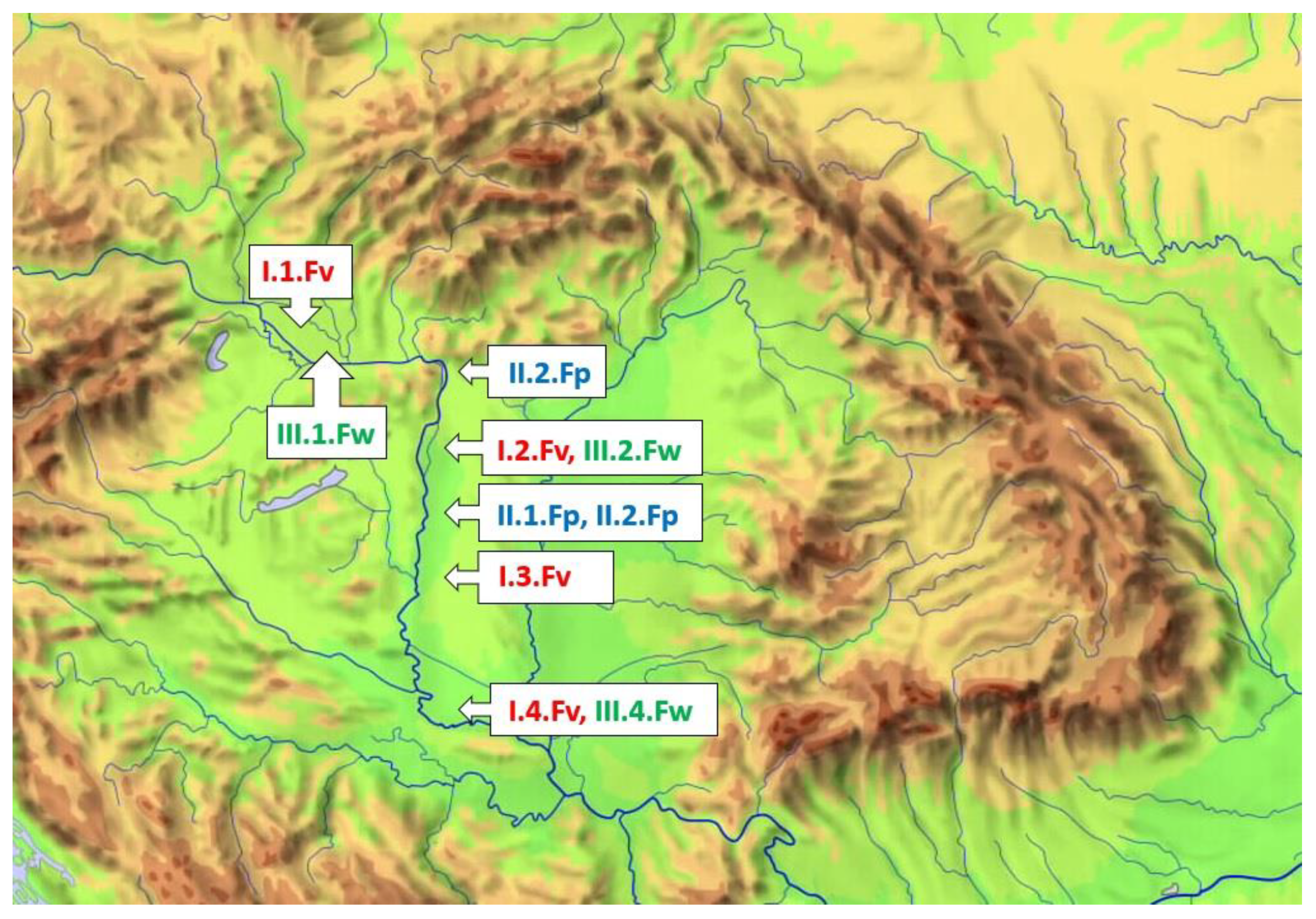
2. Materials and Methods

Coenological records were made in the central part of the Carpathian Basin, in 4 geographic units from northwest towards south and southeast. In the 4 areas dominant Festuca taxa were Festuca vaginata, F. pseudovaginata and F. wagneri, which were used as a baseline when differentiating records. The selected grasslands stretch along the Danube (Figure 1): 1. Little Hungarian Plain, Csallóköz; 2: northern part of the central area of the Carparthian Basin (Kiskunság); 3: southern part of the latter (Kiskunság) and 4: the southernmost sandy area of the Basin (Deliblát). Preferably, we chose sample areas on 3 different plain in each vegetation type.
Taking this into account, our sample areas were the following:
Festuca vaginata grows everywhere along the Danube, and it appears in every studied geographic units. We could examine 3 sample areas in each northern part: the Little Hungarian Plain (I.1.Fv); northern part of Kiskunság (I.2.Fv) and southern part of Kiskunság (I.3.Fv). On the southernmost part (Deliblato, Serbia) only 1 sample area could be analyzed (I.4.Fv).
Festuca pseudovaginata grows only in the Carpathian Basin, on the northern plane. We examined 3 vegetation types dominated by it, based on the clearly visible physiognomical differences. The first one was a degraded type dominated by weeds at Vácrátót (II.1.Fp): The other one was more diverse, containing also arboreal species at Újpest (II.2.Fp): the third one was a natural grassland at Kunpeszér-Kunadacs (II.3.Fp).
Festuca wagneri was also found everywhere along the Danube in the Pannonian Region of the Carpathian Basin: in the Csallóköz (III.1.Fw), Northern part of Kiskunság (III.2.Fw), Southern part of Kiskunság (III.3.Fw) and in the southernmost part, at Deliblát (III.4.Fw).
The following relative ecological indicators [53] were used: relative temperature requirements (TB):
1: Subnaval or supraphoric belt;
2: Alpine, boreal or tundra belt;
3: Subalpine or subboreal belt;
4: Montana coniferous forest belt or taiga belt;
5: Belt of Montana deciduous mesophilic forests;
6: Belt of submontane deciduous forests;
7: Belt of thermophilic forests and forest steppes;
8: Sub-Mediterranean shiblets and steppe belt;
9: Plants of the Eumed Mediterranean evergreen zone.
Relative soil moisture requirements (WB):
1: Plants with high drought tolerance often in areas that are completely dehydrated or persistently extremely dry (rocky, semi-desert);
2: Drought indicating plants in long dry season production areas;
3: Drought-tolerant plants, occasionally found in fresh production areas;
4: Semi-arid crops;
5: Plants of semi-natural habitats;
6: Fresh crops;
7: Moisture indicator plants, focused on well ventilated, non-wet soil;
8: Humidity indicator, but also tolerant of short flooding;
9: Groundwater signaling plants on gravely saturated (air-poor) soils;
10: Aquatic plants of areas with variable water status, dehydrating for a shorter period;
11: Aquatic organisms floating, rooted or floating;
12: Submerged aquatic plants.
Nitrogen requirements (NB).
1: Plants of sterile, extremely nutrient-poor areas (e.g., peat moss);
2: Highly nutrient-poor crops;
3: Moderately oligotrophic plants;
4: Plants of submesotrophic habitats;
5: Mesotrophic plants;
6: Moderately nutrient-rich plants;
7: Plants of nutrient-rich areas;
8: N-labeled plants in fertilized soils;
9: Over-fertilized hypertrophic habitats (shepherds’ farms), plants of ruined soils.
Taxon nomenclature was used according to [54]. Association nomenclature was used according to [5]. Values of digesting extreme climatic conditions (continentality, KB) were also used based on the 9-level scale of [55], which was based on [56]:
  • Eu-oceanic species, occurs occasionally in Central Europe (not in Hungary);
  • Oceanic species, occurs mainly in Western end Western Central Europe;
  • Oceanic/suboceanic species, occurs mainly in Central Europe;
  • Suboceanic species, occurs mainly in Central Europe and occasionally in Eastern Europe;
  • Transitory types, with a slight suboceanic and subcontinental feature;
  • Subcontinental species, occurs mainly in Central and Eastern Europe;
  • Continental-subcontinental species, occurs mainly in Eastern Europe;
  • Continental species, occurs occasionally in Central Europe;
  • Eu-continental species, occurs mainly in Siberia and Eastern Europe (not in Central Europe).
Spatial heterogeneity of soil cover was investigated by the use of a Dutch auger soil sampler and 2 soil profiles were opened and described in order to characterize the soil types of the study area. Morphological descriptions and classification of soil profiles were made on site according to international standards [57,58]. Based on our survey of soil and vegetation cover, 3 sampling sites were selected. Composite soil samples from the depth of 0–15 and 15–30 cm were collected for laboratory analysis from each selected sites and soil parameters that might be connected to vegetation were determined. Soil pH was measured in 1:2.5 soil–water suspension and in 1 M KCl, CaCO3 was obtained by the Scheibler Calcimeter, salt concentration was determined by measuring the electrical conductivity of saturated paste [59] and soil organic carbon content (%) was determined by the wet chemical oxidation method given by [60]. The Walkley and Black method [61] utilizes a specified volume of acidic dichromate solution reacting with a known quantity of soil in order to oxidize the organic carbon. The oxidation step is then followed by titration of the excess dichromate solution with ferrous sulfate, then the organic carbon content is calculated using the difference between the total volume of dichromate added and the volume titrated after reaction.
For data analysis and presenting the results, the PAST [62,63] statistical software was used. For comparing the vegetation of the different localities, multivariate hierarchic cluster analysis (UPGMA—unweighted pair-group average [64]) was conducted using Euclidean mean distance. In the present study the diversity of vegetation is particularly important, therefore after collecting, contracting the data based on vegetation types, they were also analyzed using Rényi diversity profiles [65].

3. Results

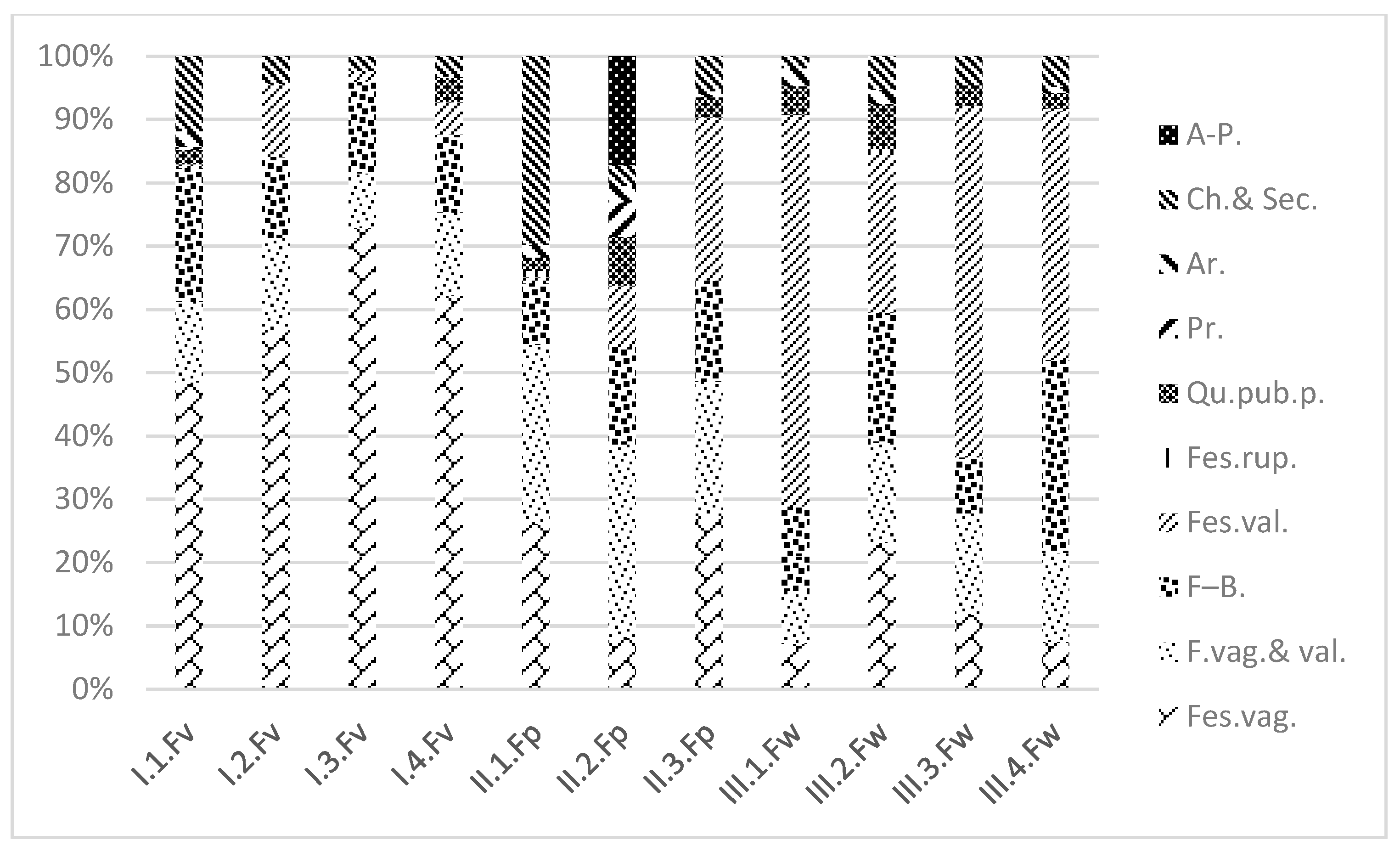
3.1. Coenosystematic Results

Based on the coenosystematic results (the role of each species within the association), association group Festucon vaginatae differed the most from the others (based on mostly Stipa borysthenica, Alkanna tinctoria, Centaurea arenaria, Dinathus serotinus and Koleria glauca (Figure 2). In F. vaginata grasslands the proportion of these open sandy grassland species was particularly high and varied between 40 and 70% in every sample area. In F. pseudovaginata grasslands these taxa covered only 10–20%. In F. wagneri grasslands these ratios were similar to those found in the central region, although in the northern (III.1.Fw, Csallóköz) and southern (III.4.Fw, Deliblato) areas they dropped under 10%.
The proportion of Festuco-Brometea Br.-Bl. et R. Tx. ex Klika et Hadač 1944 was higher on the outer edges of the examined region (I.1.Fv, III.4.Fw). Based on the common taxa of Festucetalia valesiacae and vaginatae it was clear that F. pseudovaginata grasslands showed a transition, especially in the area described as shrub-forest mosaic (II.2.Fp). There were substantial differences among the elements of subcontinental arid grasslands (Festucetalia valesiacae Br.-Bl. and R. Tx. ex Br.-Bl. 1949) with regard to their relative proportions, too. These elements, as key taxa of sandy steppes, occurred primarily in the northernmost F. vaginata grasslands in the Little Hungarian Plain. In F. pseudovaginata grasslands their proportions were higher in the shrub-forest area (II.2.Fp). In F. wagneri grasslands, their cover values were found to be the highest in the northern part of Danube-Tisza Interfluve and at Deliblato (III.2.Fw and III.4.Fw). In the Deliblato area the following species were found in large numbers: Adonis vernalis, Carex humilis and Jurinea mollis. F. tomanii was rated in Festucetalia valesiacae based on its occurrences. Elements of Festucetum rupicolae were found only in two sample areas: in the forest parts of F. pseudovaginata grasslands and in the Northern Kiskunság patches of F. wagneri.
Weed vegetation elements (Chenopodietea and Secalietea Onopordietea) occurred mainly in weedy patches of F. pseudovaginata grasslands (II.1.Fp.) (i.e., Anchusa officinalis, Aslepias syriaca, Carduus nutans, Portulaca oleracea, Setaria viridis and Tragus racemosus). Taxa of European sub-Mediterranean and subcontinental forests occurred in the forest-steppe patches of F. pseudovaginata (Quercetea pubescentis-petreae (Oberd., 1948) Jakucs, 1960) (i.e., Berberis viulgaris, Echinops schaerocephalon, Hierochloë repens and Veronica chamaedrys). These elements were also found in F. vaginata grasslands, although with lower cover values, in the northernmost and southernmost areas. Forest taxa occur also in F. wagneri grasslands, mainly in the northern part of the Sand Ridge (III.2.Fw).

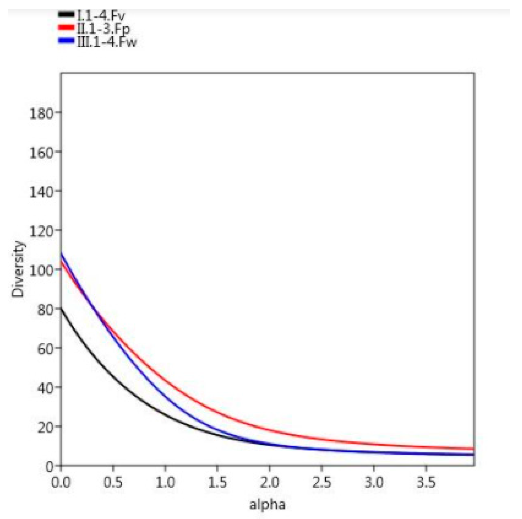
3.2. Diversity Results

Based on the Rényi diversity profile (Figure 3), it was clear that the most diverse vegetation type was F. pseudovaginata.

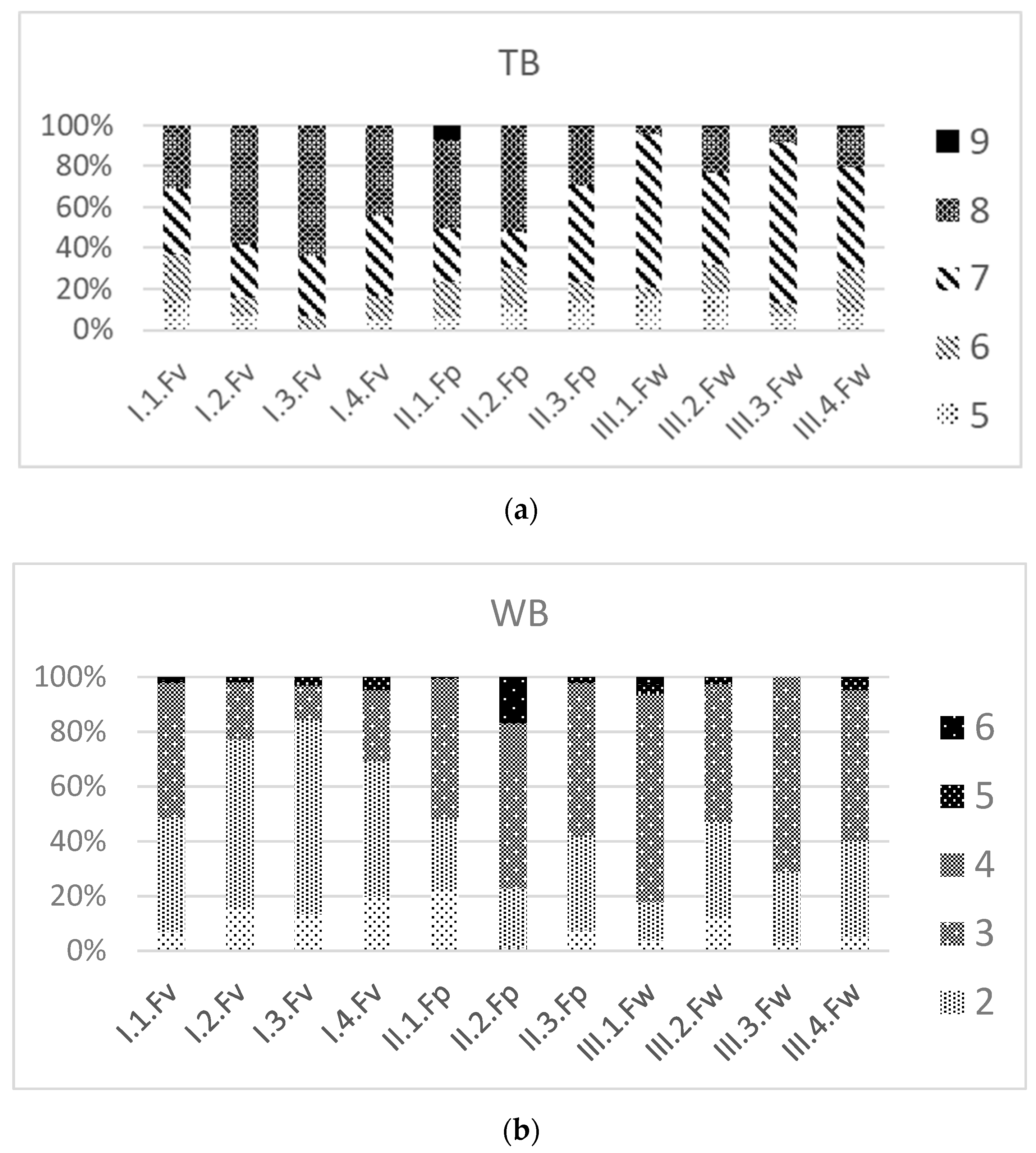
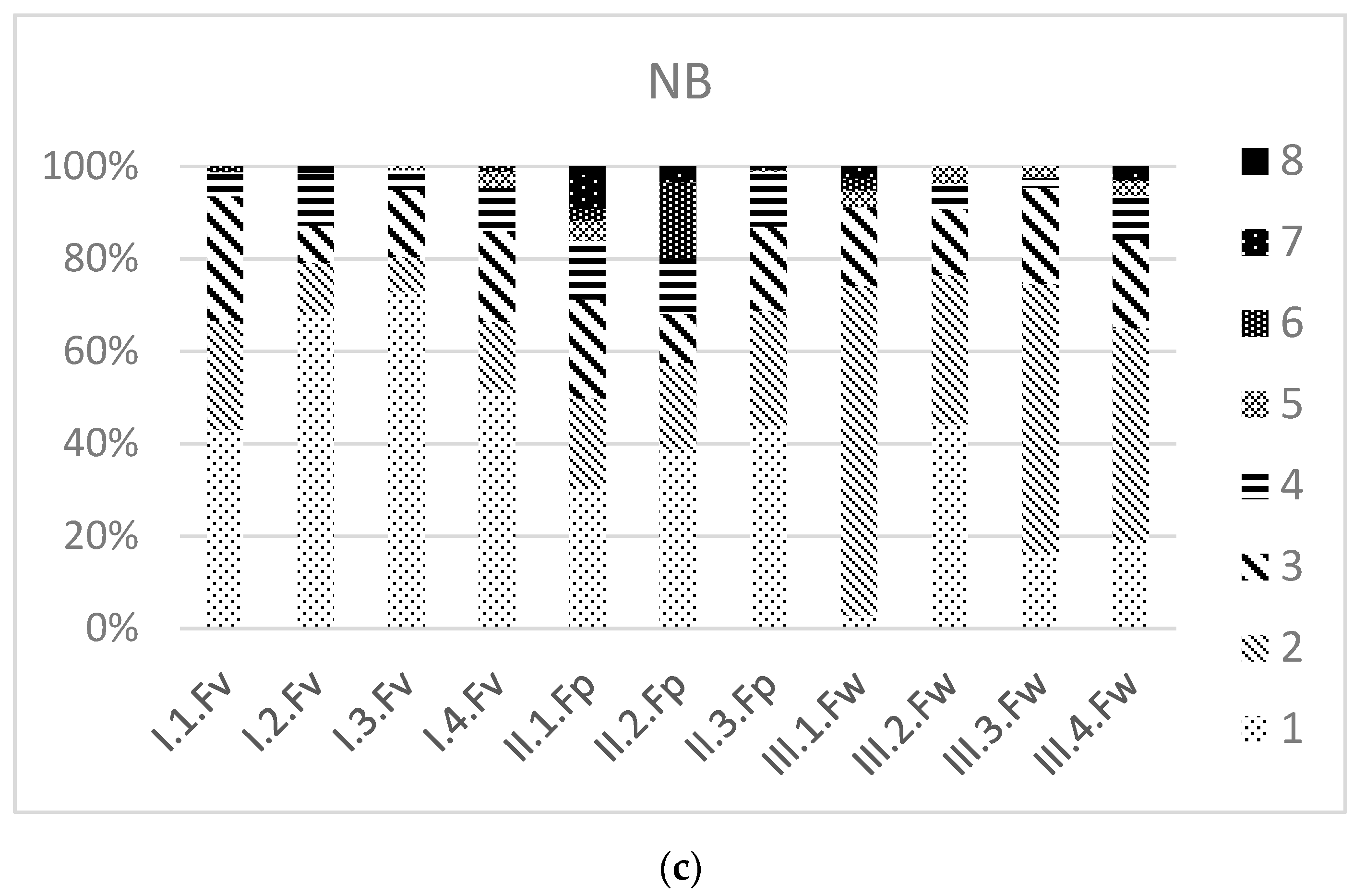
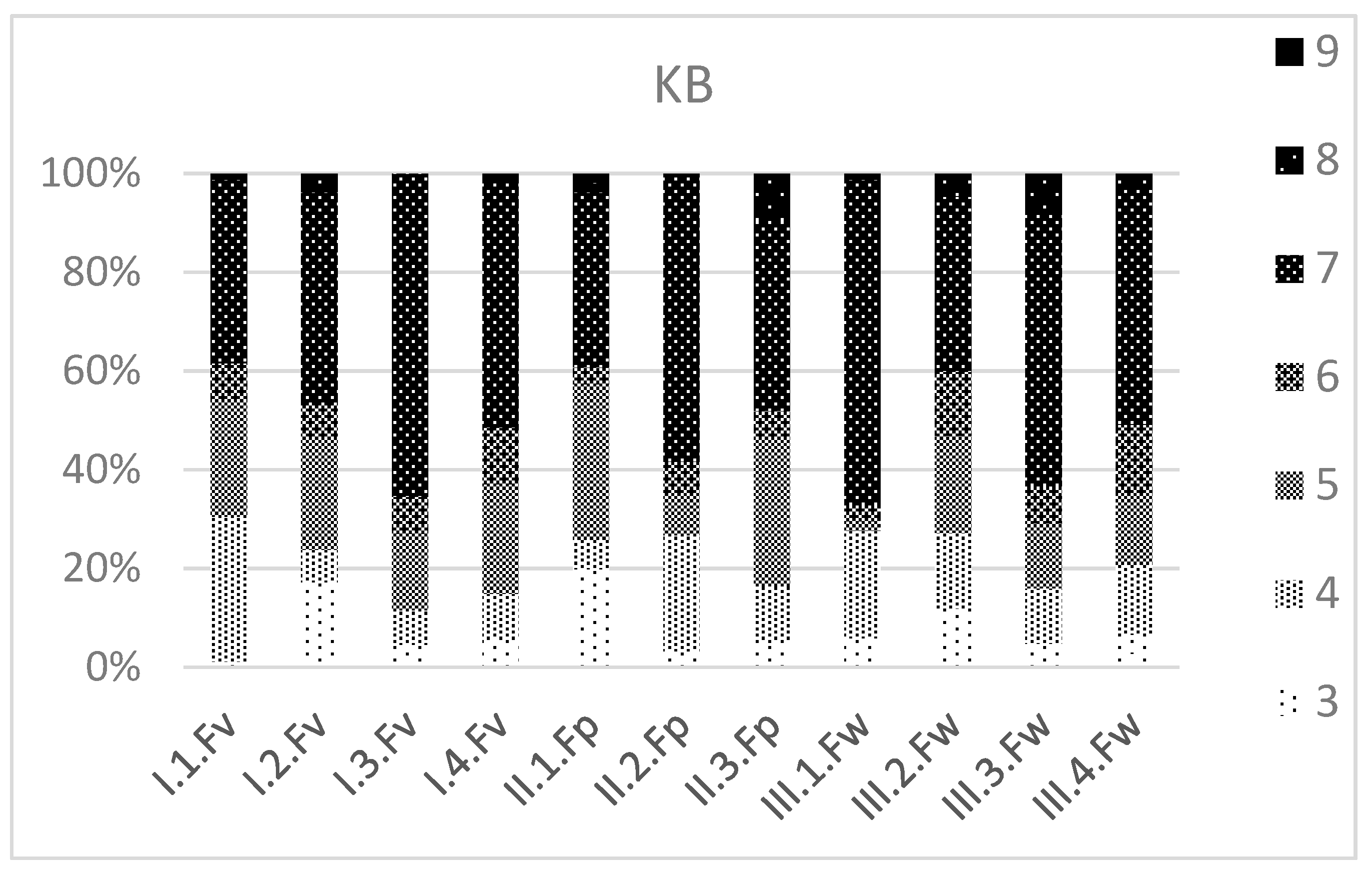
3.3. Ecological Values

We also analyzed the distribution of the relative ecological indices in the vegetation units, i.e., relative temperature, water requirements and continentality values.
F. vaginata grasslands were inhabited by species with the highest temperature requirement (value 8), although taxa with a value of 9 were to be found in secondary, weedy F. pseudovaginata grasslands (II.1.Fp). In F. wagneri grasslands, value 7 was the most common. On the two edges of the survey area, the coverages of half-shadow (value 5) and half-shadow–half-light (value 6) species were the highest. (Figure 4a).
Based on relative soil moisture requirements, F. vaginata differed from the others the most (Figure 4b). In the shrub-forest patches of F. pseudovaginata several species occurred, which indicated the borders of a wetter environment. Drought-tolerant species, which also occur in fresh habitats occasionally (value 3), were typical of F. wagneri grasslands.
Based on relative nitrogen requirements, F. vaginata differs again (Figure 4c). They contained the highest number of nutrient-poor patches. The shrub-forest patches of F. pseudovaginata were inhabited by species, which indicated larger amounts of nitrogen, which was also true for F. wagneri grasslands.
Species with continentality value of 9 (eucontinental), which occur very rarely in the Carpathian Basin, were to be found in the weedy grassland of F. pseudovaginata (II.1.Fp). Taxa with a value of 8, which are continental species marginally appearing in Central Europe, were also found. Value 7 (continental–subcontinental taxa with an Eastern European centre) had the largest proportion. Value 6 is a subcontinental category with a Central European centre; it also appeared along with value 5 (transitional types, with slight suboceanic and subcontinental features) (Figure 5).

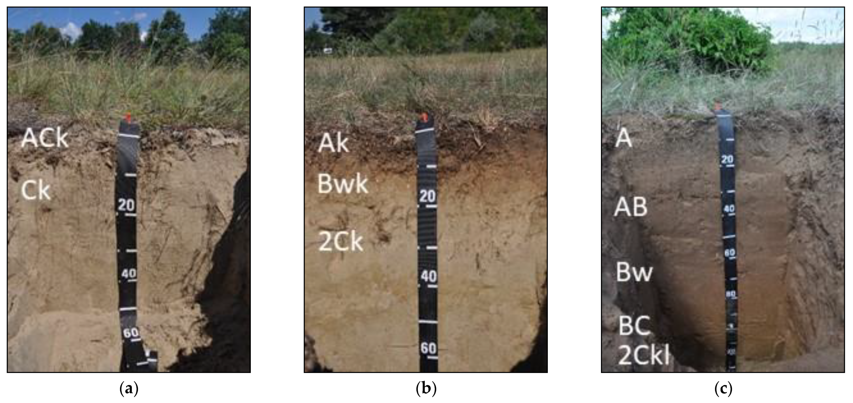
3.4. Pedological Results

The soil conditions were quite homogenous in the studied areas but small scale differences in the rate of development, SOM (soil organic matter) and carbonate content were detected in the different Festuca spp habitats.
The soil type under F. vaginata was described as Calcaric Arenosol [59] with ACk Ck profile development [57], which represents a very weakly developed calcareous soil with sandy texture (Figure 6). Based on our results, F. vaginata usually occurs in areas with the least developed, strongly calcareous sandy soil patterns, where we measured the lowest organic carbon (0.2%), and the highest carbonate content (11.3%) (Table 1).
The soil under F. pseudovaginata was more developed with Ak Bwk 2Ck profile development [54] showing moderate accumulation of humified organic matter in the surface horizon with higher organic carbon content (1.1%) and lower carbonate content (6.9%) than in the topsoil of the F. vaginata habitat (Table 1).
The soil profile showed lithic discontinuity under the Ak Bwk horizons at 18 cm depth, indicated by the presence of common (5–10%) fine and medium (2–10 mm) rounded gravel content of the surface horizons compared to the underlying gravel free sand layer. The thin appearance of this surface layer can be explained by deforestation or other human impacts, which caused deflation and thus the loss of the former surface and surface close horizons. The recent, weakly developed and humus rich A horizon may have developed on the top of the remnant B horizon of the truncated soil, which was eroded to the surface.
As a result of this thin, weakly developed appearance of the described horizons, the soil under F. pseudovaginata was also classified as Calcaric Arenosol [55] but the morphology of the Bw horizon (at a depth of 5–18 cm) still supported our hypothesis of the presence of a former forest vegetation cover in the area. The olive brown (Munsell 2.5 YR 4/3 moist) color, and the weak granular structure are typical features of pedogenic alteration, which is characteristic for the weakly developed forest soils of the Carpathian Basin. These soils are called “Brown earths” in the genetic based Hungarian soil classification system [42], and “Cambisols” (or “Brunic Arenosols” in case of coarse sandy texture) according to the World Reference Base for Soil Resources [55].
The most developed soil profile of the studied area was described under F. wagneri. The solum was 125 cm thick with A AB Bw BC 2Ckl profile development and the soil was classified as Calcaric Brunic Arenosol [55] indicating obvious signs of soil formation with horizon differentiation in the sandy subsoil. Both the morphology and the chemical properties of the genetic horizons were found typical for soils developed under (former) forest vegetation. The soil showed relatively deep humus rich A horizon (0–20 cm), transitional character (AB horizon between 20–60 cm) and had a Bw horizon (at 60–95 cm depth) with brownish discoloration (Munsell 10 YR 4/4 moist), soil structure development (weak to moderate, medium subangular blocky) and leached, carbonate free characteristics. The presence of deep, transitional A and AB horizon indicated stabile surface with closed vegetation cover, which saved the humus rich soil material from deflation and degradation.

4. Discussion

Due to significant changes in the vegetation taking place in the last few hundred years, the central sandy grassland, forest-steppe areas of the Carpathian Basin became mosaic-like [6,66] but the present survey confirmed that several patches of the original vegetation was still preserved. At the same time, new opportunities opened up for new species and associations to settle, or even new taxa to form. For the same reason, invasive species could also invade more easily [31,67].
Based on the results we could confirm that Festuca vaginata was to be found all along the Danube in sandy soils in the Carpathian Basin but it is still uncertain whether its habitat spreads all the way to the Black Sea [5]. Based on our concurrent surveys it spreads only to Romania [6,68]. Basically, this species inhabits the open sandy grasslands, in the association of Festucetum vaginatae Rapaics ex Soó 1929 em. Borhidi 1996.
In earlier literature, Festuca vaginata was treated as the only dominant grass taxon of the open calcareous sandy grasslands. This was debated by [69] when finding F. wagneri in Hungary for the first time, although he treated it as a forest-steppe species. There was no consensus on the coenological affiliation of F. wagneri, although its taxonomy was clarified by [70] when describing it as a separate species. Since older specimens lose their epidermal hairs and their sclerenchime becomes annular, a greenish grass taxon was identified as F. wagneri in samples of F. vaginata grasslands, until [71] described it as a new species named F. pseudovaginata, which also forms an association new to science [72]. Later it was confirmed that the soil parameters of this association differ greatly from the others’ [73] in terms of Ca and Mg contents. However, in the present survey soil profile was conducted for the first time, and its analysis confirmed what the environmental backdrop F. pseudovaginata indicated. This species evolved on forest soils. The soil profile showed 1.5 m deep forest soil and the amount of organic matter was higher. The relative ecological indices showed [50] that the vegetation type appeared under wetter conditions and based on their nitrogen requirement values, the soil was more nutrient-rich, which was also confirmed by the soil profiles.
F. pseudovaginata is endemic in the Pannonian region, it inhabits only the central sandy area of the Carpathian Basin. Ref. [74] provided data from the Romanian border, as its first occurrence in the country. However, there are still some uncertainties about it because F. pseudovaginata is tetraploid, while the specimens found were all diploid [75].
Coenosystematic analysis showed F. pseudovaginata mainly in forest-shrub areas and the samples also contained elements of Quercetea pubescentis-petreae and steppe taxa. In F. wagneri grasslands, proportion of taxa of Festucetalia valesiacae and Festuco-Brometea was higher. In addition, all three vegetation types were less diverse at their northern and southern edges and contained also forest, steppe and closed grassland species in larger proportions.
The present study was not extended to examine the border areas between sandy grasslands and forest vegetation, similarly to numerous invaluable and detailed works [23,24,25,76,77], although they did not examine the dominant Festuca taxa in detail. The present survey is part of a series of investigations, which examine the sandy grasslands along the Danube and the taxonomic conditions of the Festuca. As a result of our present study a new species was also discovered. Based on the soil profiles, it was clarified that these Festuca taxa can be used as indicators of disturbances in the vegetation or the onetime locations of forest patches.
F. pseudovaginata forms an association [72], not only under artificial circumstances as seen in Újpest but also at Kunpeszér-Kunadacs, where the vegetation indicates natural processes. The later is the largest continuous sandy grassland along the Danube in the Hungarian Plain, where the chances for vegetation types to evolve were the highest and its diverse environment gave an opportunity for mosaic-like landscape structure to form.
In conclusion, we answered our questions as follows: (i) According to our results, F. vaginata and F. wagneri grasslands can be considered as seminatural habitat based on their species composition and ecological indicators. F. pseudovaginata grasslands are mainly disturbed but natural patches were also found. (ii) Soils of F. pseudovaginata and F. wagneri indicate the onetime forest patches. (iii) The composition vegetation indicates its relationship with forest-steppes. Coenosystematic analysis showed F. pseudovaginata mainly in forest-shrub areas and the samples also contained elements of Quercetea pubescentis-petreae and steppe taxa. In F. wagneri grasslands, the proportions of taxa of Festucetalia valesiacae and Festuco-Brometea were higher. In addition, all three vegetation types were less diverse at their northern and southern edges and contained also forest, steppe and closed grassland species in higher proportions. (iv) The vegetation follows the aridification of the climate fast and changes rapidly into dry sandy grasslands form. The pedological results showed the memories of the changes of the soil. Answering the question in the title, the dominant Festuca species and their proportions and cover values will be the memory that indicates the vegetation types of the past in the area.

Author Contributions

Conceptualization, K.P., methodology, K.P.; software, D.S., M.F.; validation, K.P.; formal analysis, G.P.; investigation, K.P., D.S., G.P., N.P., Z.B., Z.L.-S., A.F., M.F. and E.M.; resources, K.P.; data curation, G.P.; writing—original draft preparation, K.P., M.F., G.P.; writing—review and editing, G.P.; visualization, G.P.; supervision, K.P.; project administration, G.P.; funding acquisition, K.P. All authors have read and agreed to the published version of the manuscript.

Funding

This research was funded by OTKA K-125423.

Data Availability Statement

The data presented in this study are available on request from the corresponding author. The data are not publicly available because the OTKA project is not completed yet.

Conflicts of Interest

The authors declare no conflict of interest. The funders had no role in the design of the study; in the collection, analyses, or interpretation of data; in the writing of the manuscript, or in the decision to publish the results.

References

  1. Török, P.; Janišová, M.; Kuzemko, A.; Rūsiņa, A.; Stevanović, Z.D. Grassland of the World: Management and Conservation Grasslands, their Threats and Management in Eastern Europe. In Grasslands of the World: Diversity Management Conservation; Squires, V.R., Dengler, J., Hua, L., Feng, H., Eds.; CRC Press: London, UK, 2018; pp. 64–88. [Google Scholar]
  2. Török, P.; Wesche, K.; Ambarli, D.; Kamp, J.; Dengler, J. Step(pe) up! Raising the profile of the Palaearctic natural grasslands. Biodivers. Conserv. 2016, 25, 2187–2195. [Google Scholar] [CrossRef] [Green Version]
  3. Wesche, K.; Ambarlı, D.; Kamp, J.; Török, P.; Treiber, J.; Dengler, J. The Palaearctic steppe biome: A new synthesis. Biodivers. Conserv. 2016, 25, 2197–2231. [Google Scholar] [CrossRef]
  4. Mucina, L.; Bültmann, H.; Dierßen, K.; Theurillat, J.-P.; Raus, T.; Čarni, A.; Šumberová, K.; Willner, W.; Dengler, J.; Tichý, L. Vegetation of Europe: Hierarchical floristic classification system of plant, bryophyte, lichen, and algal communities. Appl. Veg. Sci. 2016, 19 (Suppl. 1), 1–264. [Google Scholar] [CrossRef]
  5. Borhidi, A.; Kevey, B.; Lendvai, G.; Seregélyes, T. Plant Communities of Hungary; Akadémiai Kiadó: Budapest, Hungary, 2012. [Google Scholar]
  6. Molnár, Z.; Biró, M.; Bartha, S.; Fekete, G. Past trends, present state and future prospects of Hungarian forest-steppes. In Eurasian Steppes. Ecological Problems and Livelihoods in a Changing World; Werger, M.J.A., van Staalduinen, M.A., Eds.; Springer: Dordrecht, The Netherlands; Heidelberg, Germany; New York, NY, USA; London, UK, 2012; pp. 209–252. [Google Scholar]
  7. Varga, Z. Die Waldteppen des pannonischen Raumes aus biogeographischer Sicht. Düsseldorfer Geobot. Kolloqu. 1989, 6, 35–50. [Google Scholar]
  8. Tölgyesi, C.; Körmöczi, L. Structural changes of a Pannonian grassland plant community in relation to the decrease of water availability. Acta Bot. Hung. 2012, 54, 413–431. [Google Scholar] [CrossRef]
  9. Tölgyesi, C.; Bátori, Z.; Erdős, L. Using statistical tests on relative ecological indicator values to compare vegetation units–Different approaches and weighting methods. Ecol. Indic. 2014, 36, 441–446. [Google Scholar] [CrossRef]
  10. Marosi, S.; Somogyi, S. Magyarország kistájainak katasztere I-II; MTA Földrajztudományi Kutató Intézet: Budapest, Hungary, 1990; 1023p. [Google Scholar]
  11. Tölgyesi, C.; Török, P.; Kun, R.; Csathó, A.I.; Bátori, Z.; Erdős, L.; Vadász, C. Recovery of species richness lags behind functional recovery in restored grasslands. Land Degrad. Dev. 2019, 30, 1083–1094. [Google Scholar] [CrossRef] [Green Version]
  12. Bartha, S.; Campetella, G.; Ruprecht, E.; Kun, A.; Házi, J.; Horváth, A.; Virágh, K.; Molnár, Z. Will inter-annual variability in sand grassland communities increase with climate change? Community Ecol. 2008, 9, 13–21. [Google Scholar] [CrossRef] [Green Version]
  13. Bartha, S.; Molnár, Z.; Fekete, G. Patch dynamics in sand grasslands: Connecting primary and secondary succession. In The KISKUN LTER, Long-Term Ecological Research in the Kiskunság; Kovács-Láng, E., Molnár, E., Kröel-Dulay, G., Barabás, S., Eds.; Institute of Ecology and Botany: Vácrátót, Hungary, 2008; Volume 37–40. [Google Scholar]
  14. Bátori, Z.; Lengyel, A.; Maróti, K.; Körmöczi, L.; Tölgyesi, C.; Bíró, A.; Tóth, M.; Kincses, Z.; Cseh, V.; Erdős, L. Microclimate-vegetation relationships in natural habitat islands: Species preservation and conservation perspectives. Időjárás Q. J. Hung. Meteorol. Serv. 2014, 118, 257–281. [Google Scholar]
  15. Tölgyesi, C.; Valkó, O.; Deák, B.; Kelemen, A.; Bragina, T.M.; Gallé, R.; Erdős, L.; Bátori, Z. Tree–herb co-existence and community assembly in natural forest-steppe transitions. Plant Ecol. Divers. 2018, 11, 465–477. [Google Scholar] [CrossRef] [Green Version]
  16. Blaser, W.J.; Sitters, J.; Hart, S.P.; Edwards, P.J.; Venterink, H.O. Facilitative or competitive effects of woody plants on understorey vegetation depend on N-fixation, canopy shape and rainfall. J. Ecol. 2013, 101, 1598–1603. [Google Scholar] [CrossRef] [Green Version]
  17. Bertness, M.; Callaway, R.M. Positive interactions in communities. Trends Ecol. Evol. 1994, 9, 191–193. [Google Scholar] [CrossRef]
  18. Collins, S.L.; Knapp, A.K.; Briggs, J.M.; Blair, J.M.; Steinauer, E.M. Modulation of diversity by grazing and mowing in native tallgrass prairie. Science 1998, 280, 745–747. [Google Scholar] [CrossRef] [PubMed]
  19. Güsewell, S.; Le Nédic, C. Effects of winter mowing on vegetation succession in a lakeshore fen. Appl. Veg. Sci. 2004, 7, 41–48. [Google Scholar] [CrossRef]
  20. Csecserits, A.; Rédei, T. Secondary succession on sandy old fields in Hungary. Appl. Veg. Sci. 2001, 4, 63–74. [Google Scholar] [CrossRef]
  21. Tölgyesi, C.; Bátori, Z.; Erdős, L.; Gallé, R.; Körmöczi, L. Plant diversity patterns of a Hungarian steppe-wetland mosaic in relation to grazing regime and land use history (Muster der Phytodiversität in ungarischen Steppen-Feuchtwiesen Mosaiken in Abhängigkeit von der Beweidungsintensität und Landnutzungsgeschichte). Tuexenia 2015, 35, 399–416. [Google Scholar]
  22. Erdős, L.; Tölgyesi, C.; Bátori, Z.; Semenishchenkov, A.; Yu, A.; Magnes, M. The influence of forest/grassland proportion on the species composition, diversity and natural values of an Eastern Austrian forest-steppe. Russ. J. Ecol. 2017, 48, 350–357. [Google Scholar] [CrossRef] [Green Version]
  23. Erdős, L.; Török, P.; Szitár, K.; Bátori, Z.; Tölgyesi, C.; Kiss, P.J.; Bede-Fazekas, Á.; Kröel-Dulay, G. Beyond the forest-grassland dichotomy: The gradient-like organization of habitats in forest-steppes. Front. Plant Sci. 2020, 11, 236. [Google Scholar] [CrossRef] [Green Version]
  24. Erdős, L.; Kröel-Dulay, G.; Bátori, Z.; Kovács, B.; Németh, C.; Kiss, P.J.; Tölgyesi, C. Habitat heterogeneity as a key to high conservation value in forest-grassland mosaics. Biol. Conserv. 2018, 226, 72–80. [Google Scholar] [CrossRef] [Green Version]
  25. Erdős, L.; Tölgyesi, C.; Horzse, M.; Tolnay, D.; Hurton, Á.; Schulcz, N.; Körmöczi, L.; Lengyel, A.; Bátori, Z. Habitat complexity of the Pannonian forest-steppe zone and its nature conservation implications. Ecol. Complex. 2014, 17, 107–118. [Google Scholar] [CrossRef]
  26. Biró, M.; Révész, A.; Molnár, Z.; Horváth, F.; Czúcz, B. Regional habitat pattern of the Danube-Tisza Interfluve in Hungary II. Acta Biol. Hung. 2008, 50, 19–60. [Google Scholar] [CrossRef]
  27. Czúcz, B.; Révész, A.; Horváth, F.; Bíró, M. Loss of seminatural grasslands in the Hungarian forest steppe zone in the last fifteen years: Causes and fragmentation patterns. In Proceedings of the 13th Annual IALE (UK) Conference: Planning, People and Practice: The Landscape Ecology of Sustainable Landscapes, Northampton, UK, 12 September 2005; McCollinn, D., Jackson, J.I., Eds.; University of Northampton: Northampton, UK, 2005; pp. 73–80. [Google Scholar]
  28. Csecserits, A.; Czúcz, B.; Halassy, M.; Kröel-Dulay, G.; Rédei, T.; Szabó, R.; Szitár, K.; Török, K. Regeneration of sandy old fields in the forest steppe region of Hungary. Plant Biosyst. 2011, 145, 715–729. [Google Scholar] [CrossRef]
  29. Bartha, S.; Zimmermann, Z.; Horváth, A.; Szentes, S.; Sutyinszki, Z.; Szabó, G.; Házi, J.; Komoly, C.; Penksza, K. High resolution vegetation assessment with beta-diversity—A moving window approach. Agric. Inform. 2011, 2, 1–9. [Google Scholar] [CrossRef] [Green Version]
  30. Albert, Á.-J.; Kelemen, A.; Valkó, O.; Miglécz, T.; Csecserits, A.; Rédei, T.; Deák, B.; Tóthmérész, B.; Török, P. Trait-based analysis of spontaneous grassland recovery in sandy old-fields. Appl. Veg. Sci. 2014, 17, 214–224. [Google Scholar] [CrossRef]
  31. Pándi, I.; Penksza, K.; Botta-Dukát, Z.; Kröel-Dulay, G. People move but cultivated plants stay: Abandoned farmsteads support the persistence and spread of alien plants. Biodivers. Conserv. 2014, 23, 1289–1302. [Google Scholar] [CrossRef]
  32. Török, P.; Kelemen, A.; Valkó, O.; Deák, B.; Lukács, B.; Tóthmérész, B. Lucerne-dominated fields recover native grass diversity without intensive management actions. J. Appl. Ecol. 2011, 48, 257–264. [Google Scholar] [CrossRef]
  33. Török, P.; Deák, B.; Vida, E.; Valkó, O.; Lengyel, S.; Tóthmérész, B. Restoring grassland biodiversity: Sowing low-diversity seed mixtures can lead to rapid favourable changes. Biol. Conserv. 2010, 143, 806–812. [Google Scholar] [CrossRef]
  34. Prach, K.; Pyšek, P.; Šmilauer, P. Prediction of vegetation succession in human-disturbed habitats using an expert system. Restor. Ecol. 1999, 7, 15–23. [Google Scholar] [CrossRef] [Green Version]
  35. Prach, K.; Pyšek, P.; Bastl, M. Spontaneous vegetation succession in human-disturbed habitats: A pattern across seres. Appl. Veg. Sci. 2001, 4, 83–88. [Google Scholar] [CrossRef]
  36. Prach, K.; Bartha, S.; Joyce, C.B.; Pyšek, P.; van Diggelen, R.; Wiegleb, G. The role of spontaneous vegetation succession in ecosystem restoration: A perspective. Appl. Veg. Sci. 2001, 4, 111–114. [Google Scholar] [CrossRef]
  37. Szodfridt, I. Termõhelytípusok és vegetáció kapcsolata a Duna-Tisza közi homokháton. [Correlation of site conditions and vegetation in the Duna-Tisza köze-Sand plants as indicators for the sand afforestation]. Abstr. Bot. 1974, 2, 35–37. [Google Scholar]
  38. Szodfridt, I. Talajvíz és vegetáció kapcsolata a Duna-Tisza köze homokterületén. [Correlation of the soil water table and the vegetation]. Abstr. Bot. 1974, 2, 39–42. [Google Scholar]
  39. Szodfridt, I. A Duna-Tisza közi homokhátság növénytársulásainak fatermõképessége. [Timber growing capacity of the woodlands in Duna-Tisza köze]. Erdészettudományi Közlemények 1989, 10, 99–105. [Google Scholar]
  40. Járó, Z. A Duna-Tisza-közi homokhát termőhely típusai. Abstr. Bot. 1974, 2, 31–34. [Google Scholar]
  41. Dövényi, Z. Magyarország Kistájainak Katasztere; MTA Földrajztudományi Kutatóintézet: Budapest, Hungary, 2010; 876p. [Google Scholar]
  42. Stefanovits, P. A tájak talajviszonyai. In Talajtan; Stefanovits, P., Filep, G., Füleki, G., Eds.; Mezőgazda Kiadó: Budapest, Hungary, 2010. [Google Scholar]
  43. Barczi, A.; Joó, K. The role of Kurgans in the palaeopedological and palaeoecological reconstruction of the Hungarian Great Plain. Z. Geomorphol. 2009, 53, 131–137. [Google Scholar] [CrossRef]
  44. Barczi, A.; Joó, K.; Pető, Á.; Bucsi, T. Survey of the buried palaeosol under Lyukas–mound. Eurasian Soil Sci. 2006, 39, 133–140. [Google Scholar] [CrossRef]
  45. Fekete, G.; Molnár, Z.; Kun, A.; Botta-Dukát, Z. On the structure of the Pannonian forest steppe: Grasslands on sand. Acta Zool. Acad. Sci. Hung. 2002, 48, 137–150. [Google Scholar]
  46. Kun, A. Analysis of precipitation year types and their regional frequency distributions in the Danube-Tisza mid-region, Hungary. Acta Bot. Hung. 2002, 43, 175–187. [Google Scholar] [CrossRef]
  47. Tölgyesi, C.; Zalatnai, M.; Erdős, L.; Bátori, Z.; Hupp, N.R.; Körmöczi, L. Unexpected ecotone dynamics of a sand dune vegetation complex following water table decline. J. Plant Ecol. 2016, 9, 40–50. [Google Scholar] [CrossRef] [Green Version]
  48. Pawlus, M. Systematyka i rozmieszczenie gatunków grupy Festuca ovina L. w. Polsce [Classification and distribution of Festuca ovina L. in Poland]. Fragm. Flor. Geobot. 2005, 29, 219–295. [Google Scholar]
  49. Penksza, K. Kiegészítések a hazai Festuca taxonok ismeretéhez I. A Festuca psammophila series Festuca vaginata alakkörei [Additions to the knowledge of Hungarian Festuca taxa I. Taxa of Festuca psammophila series in the Festuca vaginata species complex]. Bot. Közlemények 2019, 106, 65–70. [Google Scholar] [CrossRef]
  50. Penksza, K.; Szabó, G.; Zimmermann, Z.; Lisztes-Szabó, Z.; Pápay, G.; Járdi, I.; Fűrész, A.; Falusi, S.-E. A Festuca vaginata alakkör taxonómiai problematikája és ennek cönoszisztematikai vonatkozásai [The taxonomic problems of the Festuca vaginata agg. and their coenosystematic aspects]. Georg. Agric. 2019, 23, 63–76. [Google Scholar]
  51. Korneck, D.; Gregor, T. Festuca tomanii sp. nov., ein Dünen-Schwingel des nördlichen oberrhein-, des mittleren main- und des böhmischen Elbetales. Kochia 2015, 9, 37–58. [Google Scholar]
  52. Bajor, Z.; Zimmermann, Z.; Szabó, G.; Fehér, Z.; Járdi, I.; Lampert, R.; Kerényi-Nagy, V.; Penksza, P.L.; Szabó, Z.; Székely, Z.; et al. Effect of conservation management practices on sand grassland vegetation in Budapest, Hungary. Appl. Ecol. Environ. Res. 2016, 14, 233–247. [Google Scholar] [CrossRef]
  53. Borhidi, A. Social behaviour types, the naturalness and relative ecological indicator values of the higher plants in the Hungarian flora. Acta Bot. Acad. Sci. Hung. 1995, 39, 97–181. [Google Scholar]
  54. Király, G. Új Magyar Füvészkönyv. Magyarország Hajtásos Növényei (New Hungarian Herbal. The Vascular Plants of Hungary. Identification Key); Aggteleki Nemzeti Park: Jósvafő, Hungary, 2009. (In Hungarian) [Google Scholar]
  55. Ellenberg, H. Zeigerwerte der Gefässpflanzen Mitteleuropas. Scr. Geobot. 1974, 9, 1–97. [Google Scholar]
  56. Meusel, H.; Schubert, R. Volk. und Wissen; Akademie Verlag: Berlin, Germany, 1972. [Google Scholar]
  57. FAO. Guidelines for Soil Description, 4th ed.; FAO: Rome, Italy, 2006. [Google Scholar]
  58. IUSS Working Group WRB. World Reference Base for Soil Resources 2014 (Updated 2015); World Soil Resources Reports 106; Food and Agriculture Organization (FAO) of United Nations: Rome, Italy, 2016. [Google Scholar]
  59. Buzás, I. Soil and Agrochemistry Analysing Method Book No. 1. Physical, Hydrological and Mineralogy Analyses of Soils; INDA 4231 Publishing: Budapest, Hungary, 2013; p. 357. (In Hungarian) [Google Scholar]
  60. Walkley, A.; Black, I.A. An examination of the Degtjareff method for determining soil organic matter and a proposed modification of the chromic acid titration method. Soil Sci. 1934, 37, 29–38. [Google Scholar] [CrossRef]
  61. Nelson, D.W.; Sommers, L.E. Total carbon, organic carbon, and organic matter. Methods of Soil Analysis. Part 3. Chemical Methods. Soil Sci. Soc. Am. Book Ser. 1996, 5, 961–1010. [Google Scholar]
  62. Hammer, Ø. PAST–PAleontological STatictics Version 3.06 Reference Manual; Natural History Museum, University of Oslo: Oslo, Norway, 2015; 225p. [Google Scholar]
  63. Hammer, Ø.; Harper, D.A.T.; Ryan, P.D. PAST–Paleontological Statistics Software Package for Education and Data Analysis. Palaeontol. Electron. 2001, 4, 1–9. [Google Scholar]
  64. Saitou, N.; Nei, M. The neighbor-joining method: A new method for reconstructing phylogenetic trees. Mol. Biol. Evol. 1994, 4, 406–425. [Google Scholar]
  65. Tóthmérész, B. Comparison of different methods for diversity ordering. J. Veg. Sci. 1995, 6, 283–290. [Google Scholar] [CrossRef]
  66. Bátori, Z.; Erdős, L.; Kelemen, A.; Deák, B.; Valkó, O.; Gallé, R.; Bragina, T.M.; Kiss, P.J.; Kröel-Dulay, G.; Tölgyesi, C. Diversity patterns in sandy forest-steppes: A comparative study from the western and central Palearctic. Biodivers Conserv. 2018, 27, 1011–1030. [Google Scholar] [CrossRef]
  67. Csontos, P.; Bózsing, E.; Cseresnyés, I.; Penksza, K. Reproductive potential of Asclepias syriaca stands in the rural surroundings of Budapest, Hungary. Pol. J. Ecol. 2009, 57, 383–388. [Google Scholar]
  68. Penksza, K.; Péter, N.; Saláta, D.; Pápay, G.; Lisztes-Szabó, Z.; Bajor, Z. Result of conservation management and restauration in open sandy grasslands in the Homoktövis Nature Conversation area (Budapest, Hungary). In Proceedings of the International Conference on Veterinary, Agriculture and Life Sciences (ICVALS), Antalya, Turkey, 29 October–1 November 2020, Abstract Book; Mehmet, O., Ed.; ISRES Publishing: Antalya, Turkey, 2020; p. 7. [Google Scholar]
  69. Pócs, T. A rákoskereszturi “Akadémiai erdö” vegetációja. [Die Vegetation des “Akademischen Waldes” in Rákoskeresztur]. Bot. Közlemények 1954, 45, 283–294. [Google Scholar]
  70. Penksza, K.; Engloner, A. Taxonomic study of Festuca wagneri (Degen Thaisz et Flatt) in Degen Thaisz et Flatt. 1905. Acta Bot. Sci. Hung. 2000, 42, 257–264. [Google Scholar]
  71. Penksza, K. Festuca pseudovaginata, a new species from sandy areas of the carpathian basin. Acta Bot. Hung. 2003, 45, 365–372. [Google Scholar] [CrossRef]
  72. Penksza, K.; Csontos, P.; Pápay, G. Festucetum pseudovaginatae ass. nova is a new indigenous association in the Pannonian basin. Haquetia 2020, in press. [Google Scholar]
  73. Szabó, G.; Zimmermann, Z.; Catorci, A.; Csontos, P.; Wichmann, B.; Szentes, S.; Barczi, A.; Penksza, K. Comparative study on grasslands dominated by Festuca vaginata and F. pseudovaginata in the Carpathian Basin. Tuexenia 2017, 37, 415–429. [Google Scholar]
  74. Šmarda, P.; Šmerda, J.; Knoll, A.; Bureš, P.; Danihelka, J. Revision of Central European taxa of Festuca ser. Psammophilae Pawlus: Morphometrical, karyological and AFLP analysis. Plant Syst. Evol. 2007, 266, 197–232. [Google Scholar]
  75. Fűrész, A.; Hurta, A.; Kiss, E.; Pápay, G.; Kovács, L.; Péter, N.; Lantos, C.; Penksza, K. Morphotaxonomic and ploidy analysis of dominant Festuca species in sandy grasslands along the Danube. In 62. Georgikon Napok Nemzetközi Tudományos Konferencia: A klímaváltozás kihívásai a következő évtizedekben: Előadások kivonatai; Szent István Egyetem Georgikon Kar: Keszthely, Hungary, 2020; p. 35. [Google Scholar]
  76. Erdős, L.; Krstonošić, D.; Kiss, P.J.; Bátori, Z.; Tölgyesi, C.; Škvorc, Ž. Plant composition and diversity at edges in a semi-natural forest–grassland mosaic. Plant Ecol. 2019, 220, 279–292. [Google Scholar] [CrossRef] [Green Version]
  77. Erdős, L.; Tölgyesi, C.; Cseh, V.; Tolnay, D.; Cserhalmi, D.; Körmöczi, L.; Gellény, K.; Bátori, Z. Vegetation history, recent dynamics and future prospects of a Hungarian sandy forest-steppe reserve: Forest-grassland relations, tree species composition and size-class distribution. Community Ecol. 2015, 16, 95–105. [Google Scholar] [CrossRef] [Green Version]
Figure 1. Location of the sample areas.
Forests 12 00114 g001
Figure 2. Coenosystematic composition of the grassland types under investigation. (Festuca vaginata vegetation types: I.1.Fv: Little Hungarian Plain, I.2.Fv: northern part of Kiskunság, I.3.Fv: southern part of Kiskunság, I.4.Fv southernmost part. Festuca pseudovaginata II.1.Fp: degraded type dominated by weeds, II.2.Fp: woody patches, II.3.Fp: natural patches; Festuca wagneri III.1.Fw: Csallóköz, III.2.Fw: Northern part of Kiskunság, III.3.Fw: Southern part of Kiskunság, III.4.Fw: in the southernmost part, Fes vag.: Festucion vaginatae, Fes. vag. and Festucetalia vaginatae and valesiacae, F-B.: Festuco–Brometea, Fes.val.: Festucetalia valesiacae, Fes.rup.: Festucion rupicolae, Qu.pub.p.: Quercetea pubescentis-petreae, P.: Prunion, Ar.: Arrhenatheretea, Ch. and Sec: Chenopodietea and Secaalietea, Onopordietea. A.-P.: Alno-Padion).
Forests 12 00114 g002
Figure 3. Rényi diversity of the grasslands (Festuca vaginata vegetation types: I.1-4.Fv, Festuca pseudovaginata II.1-3.Fp and Festuca wagneri III.1-4.Fw).
Forests 12 00114 g003
Figure 4. Proportions of the species based on relative ecological indices. (a) TB (relative temperature), (b) WB (relative water requirements) and (c) NB (nitrogen requirements). Festuca vaginata vegetation types: I.1.Fv: Little Hungarian Plain, I.2.Fv: northern part of Kiskunság, I.3.Fv: southern part of Kiskunság, I.4.Fv southernmost part. Festuca pseudovaginata: II.1.Fp: degraded type dominated by weeds, II.2.Fp: woody patches, II.3.Fp: natural patches. Festuca wagneri: III.1.Fw: Csallóköz, III.2.Fw: Northern part of Kiskunság, III.3.Fw: Southern part of Kiskunság, III.4.Fw: in the southernmost part. 1–9: see Materials and Methods.
Forests 12 00114 g004aForests 12 00114 g004b
Figure 5. Proportion of the taxa based on their ability to tolerate extreme climatic effects. KB: continentality. Festuca vaginata vegetation types: I.1.Fv: Little Hungarian Plain, I.2.Fv: northern part of Kiskunság, I.3.Fv: southern part of Kiskunság, I.4.Fv southernmost part. Festuca pseudovaginata II.1.Fp: degraded type dominated by weeds, II.2.Fp: woody area, II.3.Fp: natural area. Festuca wagneri III.1.Fw: Csallóköz, III.2.Fw: Northern part of Kiskunság, III.3.Fw: Southern part of Kiskunság, III.4.Fw: in the southernmost part. 1–9: see Material and Methods.
Forests 12 00114 g005
Figure 6. Soil profiles with genetic horizons [54] and classification according to the World Reference Base for Soil Resources [55]. (a) Calcaric Arenosol under F. vaginata; (b) Calcaric Arenosol under F. pseudovaginata and (c) Calcaric Brunic Arenosol under F. wagneri.
Forests 12 00114 g006
Table 1. Basic soil chemical parameters of the genetic horizons of the soils profiles sampled under F. vaginata, F. pseudovaginata and F. wagneri sites.
SiteGenetic HorizonDepth
(cm)
SOM
(%)
CaCO3
(%)
pH
(H2O)
pH
(KCl)
Salt
(%)
F. vaginataACk0–50.211.38.28.00.02
Ck5-0.111.48.68.20.02
F. pseudovaginataAk0–51.16.98.17.70.03
Bwk5–180.68.68.38.10.03
2Ck18-0.210.58.88.50.02
F. wagneriA0–201.306.76.40.01
AB20–600.806.96.10.01
Bw60–950.507.67.20.01
BC95–1250.207.67.00.01
2Ckl125-0.15.28.07.70.02
Publisher’s Note: MDPI stays neutral with regard to jurisdictional claims in published maps and institutional affiliations.

