Article

Characterizing Industrial-Dominated Suburban Formation Using Quantitative Zoning Method: The Case of Bekasi Regency, Indonesia

by
Adib Ahmad Kurnia
1,
Ernan Rustiadi
2,3,* and
Andrea Emma Pravitasari
2,3
1
Regional Planning Study Program, Department of Soil Science and Land Resources, Faculty of Agriculture, IPB University, Bogor 16680, Indonesia
2
Regional Development Planning Division, Department of Soil Science and Land Resources, Faculty of Agriculture, IPB University, Bogor 16680, Indonesia
3
Center for Regional Systems, Analysis, Planning and Development (P4W/CRESTPENT), IPB University, Bogor 16144, Indonesia
*
Author to whom correspondence should be addressed.
Sustainability 2020, 12(19), 8094; https://0-doi-org.brum.beds.ac.uk/10.3390/su12198094
Submission received: 16 July 2020 / Revised: 18 September 2020 / Accepted: 25 September 2020 / Published: 1 October 2020

Abstract

:
Suburbanization of Bekasi Regency as a part of the Jakarta Metropolitan Area (JMA) is mainly induced by urban expansion and industrialization, in which the suburbanization process threatens food security and ultimately disrupts urban sustainability. This study aims to characterize industrial-dominated suburban formation to manage the suburbanization process using a quantitative zoning method. In assessing the characteristics of industrially dominated suburban, this research utilizes the concept of urban–rural development (URD), which consists of five aspects of development (socioeconomic, population, industrial, land-use, and environmental). Factor analysis and Rustiadi’s spatial clustering form regional clusters using all variables while referring to the URD concept. The results showed that there are three regional typologies: (i) urban, (ii) Desakota, and (iii) rural regions. Urban regions are situated in the central and western parts of Bekasi Regency, rural regions are situated in the northern part of Bekasi Regency, while the desakota region is situated between urban and rural regions. Characteristics of each typology then could be used as the basis for development policy in Bekasi Regency which is then constructed towards the protection of agricultural areas in the rural and desakota regions, serving both food security function and strengthening urban sustainability of JMA.

Graphical Abstract

1. Introduction

Background

Suburbanization is closely related to urbanization process, where it is considered at the post-urbanization stage and is defined by the number of urban populations moving to live in the peri-urban area due to congestion and environmental degradation in urban centers [1,2]. The term suburbanization was first known in North America and Western Europe, where it is defined by rapid growth in peri-urban areas due to the movement of urban communities and the development of industrial areas [1,3]. Unlike suburbanization in North America, most of the suburbanization phenomena, mainly in Southeast Asia, was more often caused by rapid urbanization that led to expansion of urban regions [4,5,6]. Urban expansion, especially in major cities of the Southeast Asia region, is due to the centralized development process following earlier stages of economic development experienced in the 1980s [5,6]. The development process, which is mostly financed by foreign direct investment (FDI), has led to an increase in rural-urban migrants to big cities in Southeast Asia [5].
Expansion of its metropolitan area characterizes most of the suburbanization process in Southeast Asia, and interaction with its hinterland resulted in the Extended Metropolitan Region [7,8,9]. Expansion of metropolitan areas in Southeast Asia, especially Bangkok, Jakarta, and Manila, extends to rural regions with a high-density population and is mainly a rice-production area [10,11]. This expansion causes many metropolitans to have a biased boundary between urban and rural regions [6]. This biased boundary between urban and rural regions gave rise to a new term for regional classification in urban geography, namely the “desakota” region [12]. The desakota region is an area that cannot be classified as urban or rural regions because it has both properties [13,14].
This desakota region can be found in the periphery or peri-urban areas of the metropolitan areas in Asia and can be observed in the Jakarta Metropolitan Area (JMA) [11]. The Jabodetabek Metropolitan Area (Jakarta—Bogor—Depok—Tangerang—Bekasi) or the Jakarta Metropolitan Area is one of the largest metropolitan areas in Asia, which is the result of core metropolitan (Jakarta) expansion, where the population reaches more than twenty million [15,16]. Based on Presidential Regulation No. 60/2020 concerning the spatial planning of the Jabodetabekpunjur area, the Jabodetabek Metropolitan Area is planned to become one of the national economic activity centers to promote equitable community welfare and sustainable development. In general, the JMA is divided into three zones (core zone, inner ring zone, and outer ring zone), where the direction of expansion moves towards the inner and outer ring zones due to the inability of the metropolitan core to accommodate the increasing population density [16,17].
Bekasi Regency is one of the outer ring zones of the JMA that is directly affected by its metropolitan core [18,19], and that undergoes industrialization process to support JMA’s economic activities [17]. The industrialization process contributed to the increase in the Bekasi Regency GDP, where foreign capital played an essential role in the speed and significance of the industrialization process in Bekasi Regency [16]. The contribution of the industrial sector to Bekasi Regency regional revenue is shown in the manufacturing industry sector as the dominant contributor to the Bekasi Regency’s GDP in 2017 by 78.37% [20]. The industrialization process in Bekasi Regency was also caused by the shifting of industrial manufacturing area from a crowded city center to a more “open” space in the outskirts or fringe areas of the metropolitan, which is commonly referred to as “industrial suburbanization” which occurs in urban regions of developed countries since the 1990s [3].
The industrial suburbanization process in Bekasi Regency is driven by the private sector [4,5,21]; it is only oriented towards developing residential and industrial estates without paying attention to agricultural areas. These estates increasingly threaten food security in the JMA [22,23], where 46.34% of agricultural land has been converted into a built-up area during 2000–2015 [24]. This type of development will only orient itself towards the upper-middle-class society and will lead to spatial and social segregation between the poor and rich in suburban areas. [4,22,25]. This segregation is commonly referred to as dualism of urbanization in suburban areas, which lacks government intervention in the development process in suburban Bekasi [25].
Besides, the industrial suburbanization process in Bekasi Regency has caused some of the rural regions to be transformed into an urban region [17]. The urban region in Bekasi Regency is dominated by urban land-use coverage, low to no agricultural area, and most settlements area, while the rural region has a relatively low urban land-use and is still dominated by agricultural areas [6,26]. However, some regions have been transformed into a “grey” region because they have mixed land-use, where the urban and rural land-uses are very close and interrelated [2,22]. Regions with mixed land-use and interrelation between one another constitute the desakota region [17]. The emergence of a desakota region in Bekasi Regency is caused by the imperfect transformation from rural to urban without being accommodated by proper planning from the government [25,27].
Moreover, the industrial suburbanization process in Bekasi Regency divides this regency into several regional typologies, namely urban, rural, and desakota regions [17]. This study aims to characterize industrially dominated suburban formation (regional typology) in order to manage the suburbanization process using a quantitative zoning method. Characterization of regions affected and/or formed by suburbanization is indeed needed to reclassify the regions in Bekasi Regency to formulate a better strategy or policy to manage and sustainably accommodate this industrial suburbanization process.
The needs of characterization are more emphasized by the fact that the Bekasi Regency is not a homogenous region, where this suburb has a diverse landscape and socio-economic conditions. It means that there are urgent needs to differentiate and characterize suburban regions on a smaller scale to promote a better development policy based on the characterization results. In terms of Bekasi Regency, rural and desakota characterizing is needed to provide a better picture in Bekasi Regency’s agricultural area protection [22], in which this region has experienced a massive conversion of agricultural land due to the process of suburbanization [13,21,22]. Bekasi Regency is a vital area for national rice production and especially the JMA, where conversion of agricultural land due to the suburbanization process has threatened food security in the JMA and, therefore, threatened its sustainability [22,23].
Regional typology characterizing and mapping in Bekasi Regency is needed to identify which areas should be designated for industrial and residential development and which areas should be designated for agriculture protection. Regional typology identification in this research is based on a comprehensive indicator from an urban–rural development approach. The urban–rural development (URD) approach consists five development aspects, namely socioeconomic, environmental, population, land-use, and industrial [28], which also reflect the pillars of sustainable development (social, economic, and environmental pillars), where sustainable development is a mainstream development paradigm in the 21st century [29,30]. This approach is more comprehensive than previous research by Rustiadi et al. [31] and by Hudalah and Firman [2] in identifying regional typologies in Bekasi Regency, where Rustiadi et al. [31] study is only based on a single variable and does not include classification of the desakota region while Hudalah’s and Firman [2] research are solely based on socioeconomic conditions. This research uses factor analysis in Principal Component Analysis (PCA) to reduce many variables (regional characteristics) into new mutually independent variables that do not have a multicollinearity problem. PCA application in planning-related study is often coupled with Geographic Information System (GIS) [32] to examine spatial dynamics of a region [33] and socioeconomic studies [34] or as an evaluation and monitoring tool in development [35].
Moreover, this study pays attention to spatial proximity in theologizing or classifying regions in Bekasi Regency, whereas, in a similar research that uses the URD approach by Hu et al. [28], spatial contiguity aspect was not used. The use of spatial contiguity aspects is essential because a region cannot function properly by itself and the adjacent region will likely have a close similarity relationship [36]. Besides, a compact or contiguous region will be easier to manage than a fragmented region [37]. Spatial clustering, which is one of the quantitative zoning analysis methods, serves to group regions that have similar characteristics, also considering spatial proximity so that the delineation result will be more compact [38].
This research offers to fill in a particular gap with this methodological approach. Several studies regarding suburbanization in Indonesia have been carried out, with each of them providing different perspective, for example, Hudalah and Firman [2], and Firman and Fahmi [4] using a descriptive approach explaining suburbanization in Jakarta and its surrounding area. Wagistina et al. [39] used GIS-coupled with a qualitative approach to describe the suburbanization pattern in Malang, Indonesia. There still has not been any research explaining suburbanization (especially industrial suburbanization) in Indonesia using a zoning approach to develop a particular characterization and development policy. However, this research also has several limitations due to data limitation and the nature of planning and development policies. Where planning and development policies in Indonesia are usually summarized in a regency-scale, programs or policies on a smaller scale are usually not prioritized, meaning that macroscale development is still the mainstream paradigm implemented in Indonesia currently.

2. Materials and Methods

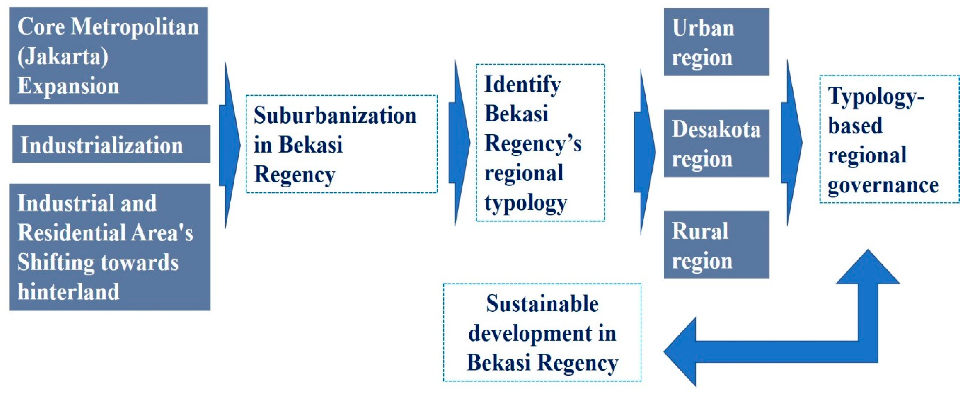
2.1. Research Framework
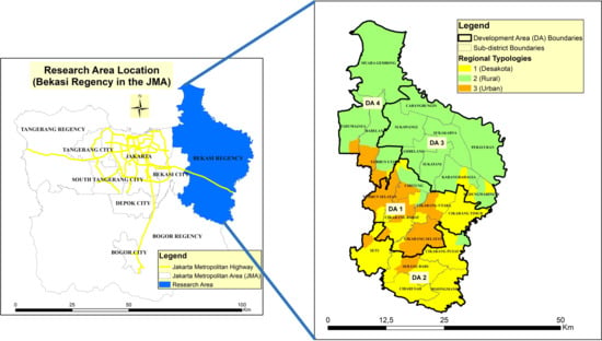
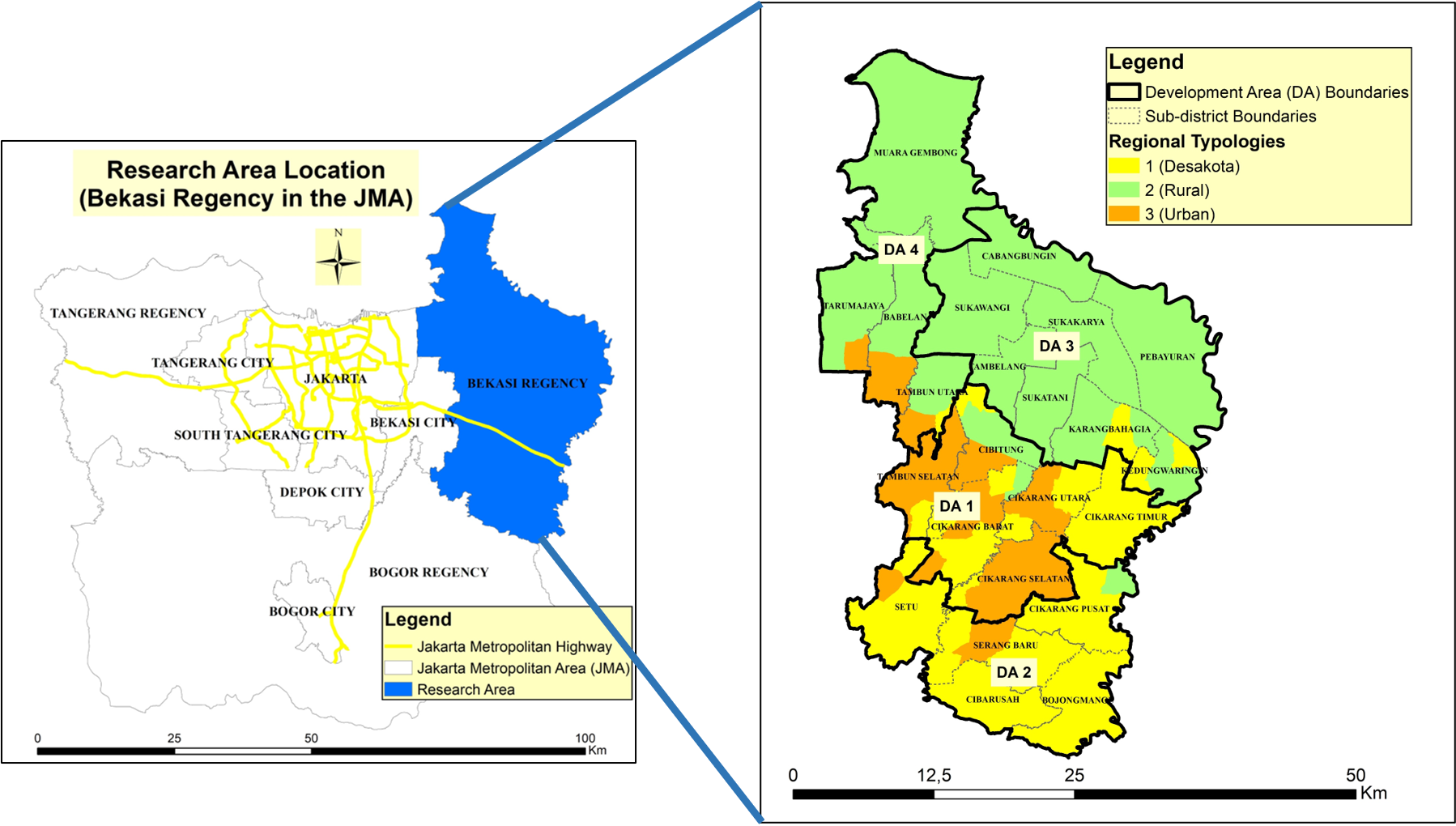
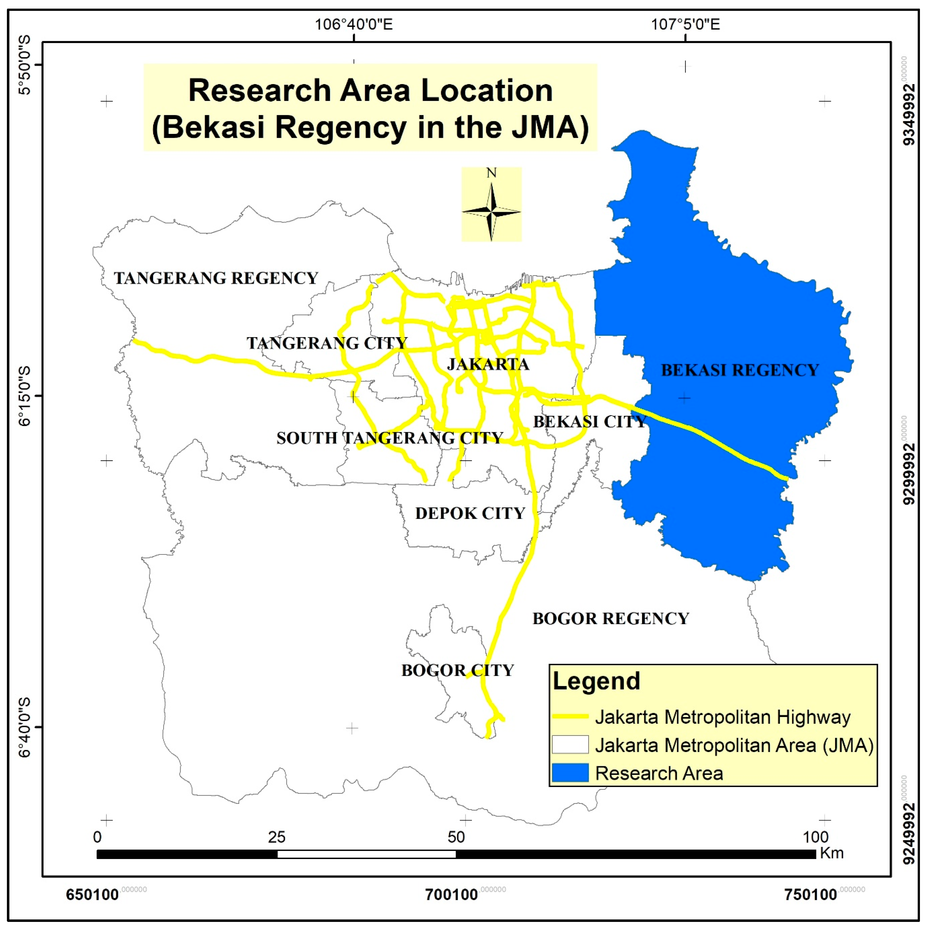
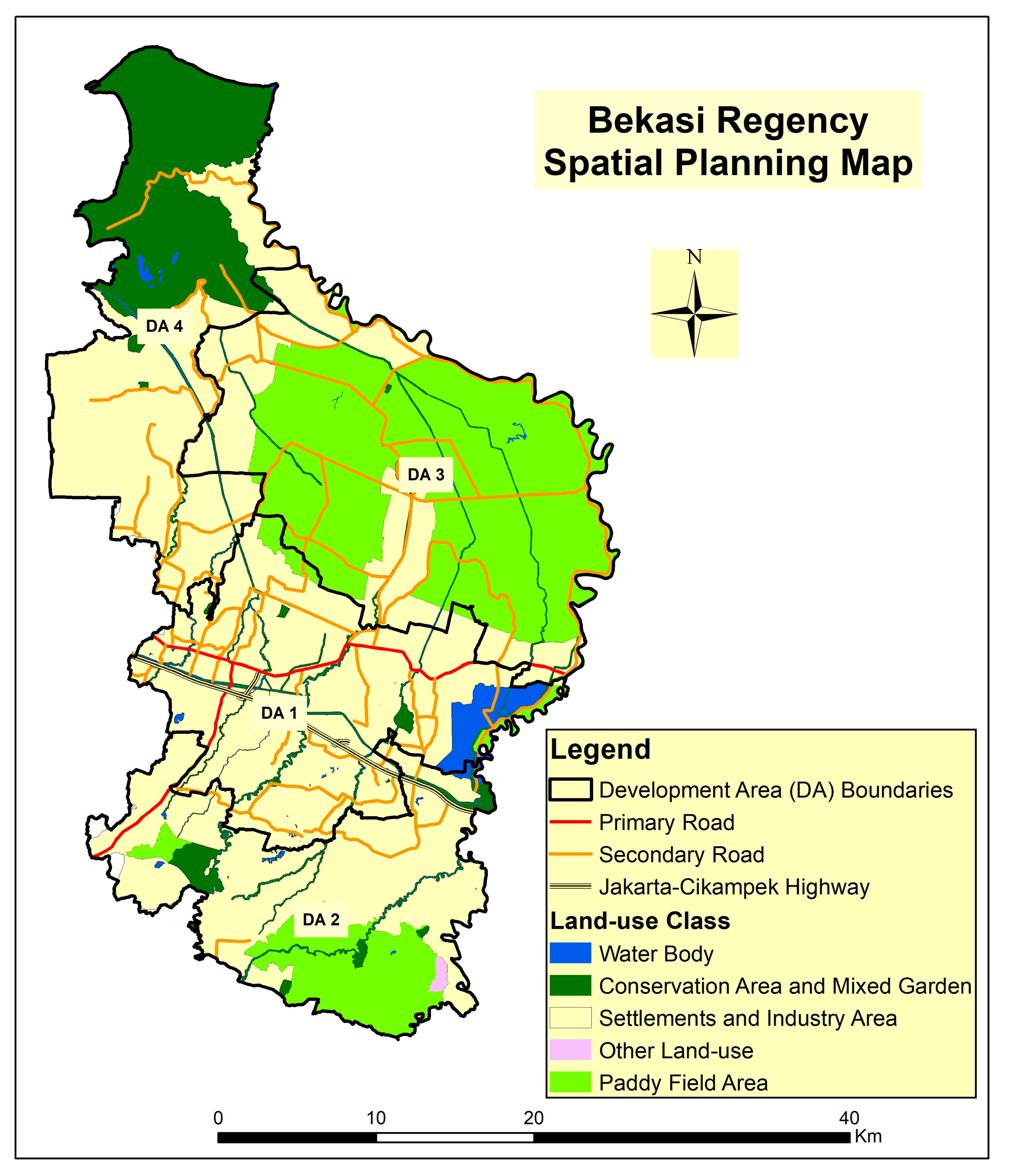
Bekasi Regency, as a peri-urban area of the Jakarta Metropolitan Area (JMA), experiences suburbanization due to the spillover effect and urban expansion from Jakarta’s rapid urbanization. The suburbanization process in Bekasi Regency is also supported by the process of industrialization [13,40], resettlement from the metropolitan core [25], and movement of industrial estates from metropolitan core [40] (see Figure 1). The suburbanization process caused Bekasi Regency to be divided into three major typologies: rural, urban, and desakota regions. The regional typology identification process uses the URD concept approach, where the development aspects within URD are also a reflection of sustainable development pillars: social, economic, and environmental pillars [29,30]. Identifying regional typologies in an area with high dynamics such as Bekasi Regency has become essential, as planning and development policies need to have detailed instruction based on each region [41]. The primary focus of typology-based development policy in this context is more towards the preservation of agricultural areas to promote food sovereignty and sustainable development of the JMA and especially Bekasi Regency [22]. Food security is also an essential issue in sustainable development, especially in metropolitan areas in developing countries that have a large population and experience rapid urbanization [30].

2.2. Study Area

This study examines Bekasi Regency as one of the peri-urban areas within the Jakarta Metropolitan Area (JMA), which underwent the suburbanization process and is commonly known as “Jabodetabek” (Jakarta—Bogor—Depok—Tangerang—Bekasi). The JMA is a nodal region system which consists of core and hinterland areas [42], where Bekasi Regency is the metropolitan’s hinterland [13,17]. Bekasi Regency has 126,050 hectares total area, is located in the eastern part of the JMA, and is located on the north coast of Java (Figure 2). This region is traversed by the Jakarta–Cikampek highway and North Java primary road, making it a strategic area for industrial and residential area development [40]. Based on the 2019 Statistic Central Agency (BPS) data, Bekasi Regency is a peri-urban area of the JMA with its highest population growth at 3.49% per year and a population density of 2850 people/km2 [20]. In contrast to other regencies in Indonesia, where most of the areas are still rural and the majority of its population’s occupation is farmers, Bekasi Regency has a high urban population composition reaching 83.35% while the number of families that depend on the agricultural sector is only 30%.
Based on Jakarta Metropolitan Area and Bekasi Regency spatial planning, Bekasi Regency is designated to develop industrial as well as agricultural areas. This directive is in line with West Java spatial planning, which addresses Bekasi Regency as a region for developing environmentally friendly industries [43]. Bekasi Regency consists of 4 Development Areas (DA) in which DA 1 is designated as the center of industrial and residential area development. In its development stage, DA 1 is a location for developing large industrial estates supported by transportation network development to increase its accessibility, such as improving the Jakarta–Cikampek highway and the North Java primary road [40]. In contrast, DA 3 is directed to develop the agricultural sector, while DA 2 and DA 4 are developed as transition regions (Figure 3). Most areas of Bekasi Regency, especially DA 3, are in the lowlands, which have quite extensive irrigated agricultural land with reasonably fertile soil conditions [24].

2.3. Data Collection

This study uses village-level administration as its analysis unit. The data used in analyzing the typology of the Bekasi Regency is village-level statistical data related to the five development aspects of the urban–rural development concept [28]. The urban–rural development (URD) concept is used to pay a closer attention to the five development aspects in viewing transformation of urban–rural regions [28], such as (1) the composition and rate of population growth (population aspect) [44,45]; (2) land-use structure (land-use aspect) [46,47]; (3) socioeconomic condition [48]; (4) industrial development [49]; and (5) environmental aspects [50,51,52]. Based on the five aspects of the URD concept and the availability of village-level statistic data related to URD, thirteen variables are chosen that reflect all aspects of the URD. All variables are positively associated with the URD value, with the exception being that the ratio of small- and medium-scale industries to the total population variable (I3) is inversely related (Table 1). A variable that has a negative relationship with URD means that the relationship between the variable value and the URD value is opposite so that the raw data from this variable I3 needs to be inversed. The source of all statistical data is from the Village Potential Data (PODES) in 2018, released by the Central Statistics Agency (BPS).
The population variable (K1, K2, and K3) in the URD concept denotes urbanization forces in terms of human capital as well as shows transformation and classification of a region to be considered as rural or urban areas, with population growth and density being the main characteristics on population variable [53]. The land-use (P1, P2, and P3) variable in the URD concept indicates the main activities. The land-use variable has also been used for several studies to explain urban expansion, which is often represented in built-up and agriculture land-use coverage [54,55]. The socioeconomic variables (S1 and S2) illustrate suburbanization, or more often, sprawl often shows variables concerning the negative impact of suburbanization, such as slum area and health or living quality [56]. Industrial development aspects—in this context, industrial suburbanization—are especially essential to explore in determining transformation caused by this type of suburbanization. Industrial development variables (I1, I2, and I3) represented by number, ratio, and coverage of industrial areas are used to characterize regions formed by suburbanization in industrial areas [57,58]. Significant impacts of suburbanization are directly felt by the environment, as it tends to degrade the environment in place of economic (in this case, it is majorly industrial) growth, with the most eminent variables (L1 and L2) in this context being the quality of water resources and green open space or vegetation in the region [53,59].

2.4. Data Processing

This study uses factor analysis with Principal Component Analysis (PCA) to simplify the variables (13 variables). New, mutually independent variables will be generated and will be able to explain all thirteen variables by grouping variables that have the same characteristic values [60]. Principal Component Analysis (PCA) is an analysis technique that can describe patterns of variation in multidimensional datasets and can reduce the dimensions of the dataset. PCA analysis technique is a mathematical procedure that used to reduce the dimensionality of large data sets, by transforming a large set of variables into a smaller one, called the main component. The number of main components is always less than or equal to the number of original variables. Variable simplification in PCA is defined in a way to eliminate multicollinearity between variables [61]. This simplification is achieved by transforming into a new factor (the main component) that is not correlated so that the new factor retains most of the variation that exists in all original variables [61,62]. This simplification also intends to make it easier to analyze differences in characteristics between typologies in the regions of Bekasi Regency. Factor analysis is conducted using extraction methods, namely principal component, and the rotation method used is normalized varimax. Before the factor analysis stage is carried out, data that is negatively related to the URD (variable I3) needs to be inversed using the formula in Equation (1), and all data must be standardized (Equation (2)).
B i j   =   1 X i j
X i j   s t a n d a r d i z e d   =   X i . j m e a n   ( x i ) s t . d e v   ( x i )
where Xi.j = the value to be standardized from the ith row and jth column contingency matrix; mean (Xi) = the mean value of a contingency matrix in the ith row (the row where the data will be standardized); stdev (Xi) = standard deviation of the contingency matrix in line i (the row where the data will be standardized); Bij = index of inverse data; and Xij = the ith region value on the jth variable.
This study uses multidimensional data with a combination of spatial and nonspatial data to provide an objective regional classification with a compact and contiguous classification, which also make it easier to formulate a development policy used to solve the complexity of suburban regions. After variable reduction is obtained using factor analysis, then the new variable (factor) can be carried out in the next stage of analysis, quantitative zoning analysis, to see the typology and suburban area of Bekasi Regency. Quantitative zoning in its nature is a quite versatile concept, with implementation ranging from ecological uses [63], landscape management [64], to tourism management [65]. This research aims to use quantitative zoning approach to explain industrial suburbanization occurring in Bekasi Regency and its implementation to formulate a development strategy based on the zoning results.
Spatial clustering as a quantitative method is a clustering result that considers spatial attributes as one of the data’s characteristics in a way that it still aims to identify homogeneous groups of objects based on the values of their attributes [66,67]. In a spatial dataset, spatial characteristics allow data to behave differently, with neighborhood and contiguity aspects to be considered. Spatial clustering also permits generalization of the spatial component like exact location and extension of spatial objects, meaning that how data is spatially allocated in geographical space is essential to discuss and explain a better point of view [68]. In its application, spatial clustering is often used to describe the composition of a city, its spatial structure, and land-use zoning [69,70] as well as some kind of spatial phenomenon like segregation and sprawl [71,72]. Spatial clustering analysis is used in this research because it is necessary to pay attention to spatial contiguity aspects. The spatial contiguity aspect is essential in regional studies, where it is one of the applications of Tobler’s Law [36]. Tobler’s law is a critical pillar for regional or spatial studies, where the law explains that all things are related to one another, where something close to another will be linked more than the one that is far apart [36]. The spatial clustering analysis used in this study is Rustiadi’s spatial clustering method 1, with the formula presented in Equation (3) [38].
D i j =   ( z 1 i z 1 j ) 2 + ( z 2 i z 2 j ) 2 + + ( z m i z m j ) 2 + β { ( X i X j ) 2 + ( Y i Y j ) 2 }
where Dij is the Euclidean distance value between object i and j; zi and zj attribute values for locations i and j (in univariate cases); and for attributes m, zmi and zmj are attribute values for locations i and j for zm variables (in the case of multivariate) and zmi′ and zmj are standardized values of zmi and zmj
Contiguity factors will be stronger (a cluster formed will be more influenced by spatial distance) when β value is β > 1 and will be weaker (a cluster formed will be more influenced by variables value) when β value is β < 1. This research uses four different spatial contiguity weights: β = 0.5, β = 1, β = 1.5, and β = 2. The selection of the four spatial contiguity weights is to compare the resulting clusters between the spatial contiguity weights β < 1 and β > 1, where β = 0.5 represents β < 1 while β = 1.5; and β = 2 represents β > 1. The clusters are then compared using CV (Coefficient of Variance) and contiguity (K) value to determine the best clusters. The CV indicator is the main indicator to determine the best spatial contiguity weight, where the lower CV value will indicate the less variety between cluster members, representing a better cluster. CV value is calculated based on standard deviation (σ) and mean (µ) value of Euclidean distance in each member of the cluster (Equation (4)). The contiguity (K) indicator is a complementary indicator of the CV indicator, which determines the best contiguity (K) value seen from the spatial contiguity weight, which has the least number of polygons.
C V   ( % ) =   σ μ

3. Results

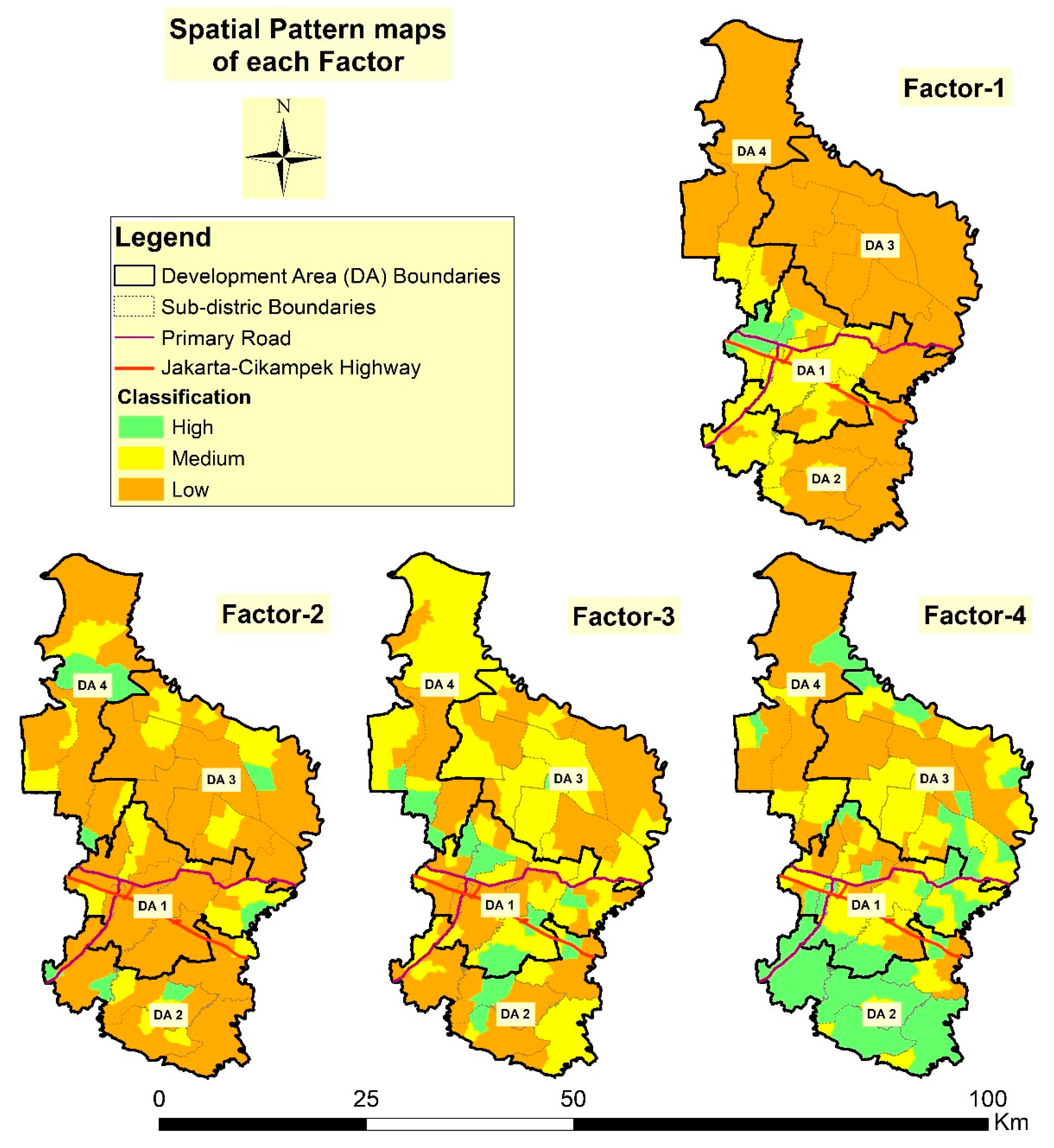
3.1. Factors Determinant of Regional Typology

Factor analysis using Principal Component Analysis (PCA) aims to reduce many variables into several factors or variables that are mutually independent and identical [73]. The selection out of thirteen variables or indicators is based on the representativeness of urban–rural development (URD), the five aspects of development [28], and the availability of data at the village administration level. The thirteen variables were reduced to eleven variables after being tested using PCA, as seen from the significance value of each variable in the PCA model (see Table 2). Variables I1 and K1 were reduced from the model because they do not show a significant value on any of the factors; these results indicate that the variable did not fit in the model [73]. Each variable will be significant (>0.70 factor loading value) on a specific factor, with the significant value shown in Table 2. For example, the percentage of built-up area (P1), percentage of non-paddy field area (P2), and the percentage of settlement area (P3) have significant values at factor 1 (Table 2). Variables that have a significant value on the same factor can be interpreted that these variables have the same characteristic values in each case (village) or that the value of factor represents the characteristics of these variables. The PCA model produced in this study is considered valid, as shown by a high cumulative eigenvalue percentage, reaching 78.24% or exceeded 70% [73].
Based on the significance value (0.70), the eleven variables are then reduced to four factors, which means that the factor value will represent the characteristics of the variable value that is significant on that factor. Each factor in the PCA model has an eigenvalue value, reflecting the level of importance of the variables in a PCA model [73]. Factor 1 has the largest eigenvalue value in the PCA model produced, with a 3.96 eigenvalue score, which means that this factor is the most important distinguishing factor and has characteristics unique to other factors (Table 3). Despite experiencing variable reduction, these four factors still represent the five aspects of development in URD, namely land-use, industrial, socioeconomic, population, and environmental aspects. For example, factor-2 is a representation of industrial development, and it is reflected in the value of a significant variable in this factor: the number of small- and medium-scale industries (I2) and the ratio of small- and medium-scale industries to the total population (I3).
The function of factor analysis using PCA is to reduce the number of variables by creating several factors representing a number of variables and that are mutually independent [73]. The nature of independence is shown from the spatial pattern of each factor’s value, where each factor has a different spatial pattern (Figure 4). The division of high, medium, and low levels for each factor value is based on the natural break method, in which this method is designed to optimize the adjustment of a set of values into natural classes, where villages with a high value on the map will be green. In contrast, those of low value will be brown. For example, villages that have a high value for factor 1 (representing physical development aspects or urban land-use) are concentrated in DA 1, while villages that have a low value for factor 1 are concentrated in DA 3 (Figure 4).
Based on spatial pattern in factor 1, it can be concluded that the built-up area is concentrated in DA 1, whereby in the directive from Bekasi Regency spatial planning, DA 1 is indeed directed for the development of industrial and residential areas. DA 1 is the location of the Tambun and the Cikarang regions, both of which are large industrial areas and densely populated settlement areas [5,17]. DA 3 has a low value on factor 1 because it is mostly agricultural, especially paddy field, while the northern part of DA 4, which also has a low value, is a mangrove conservation area [24].

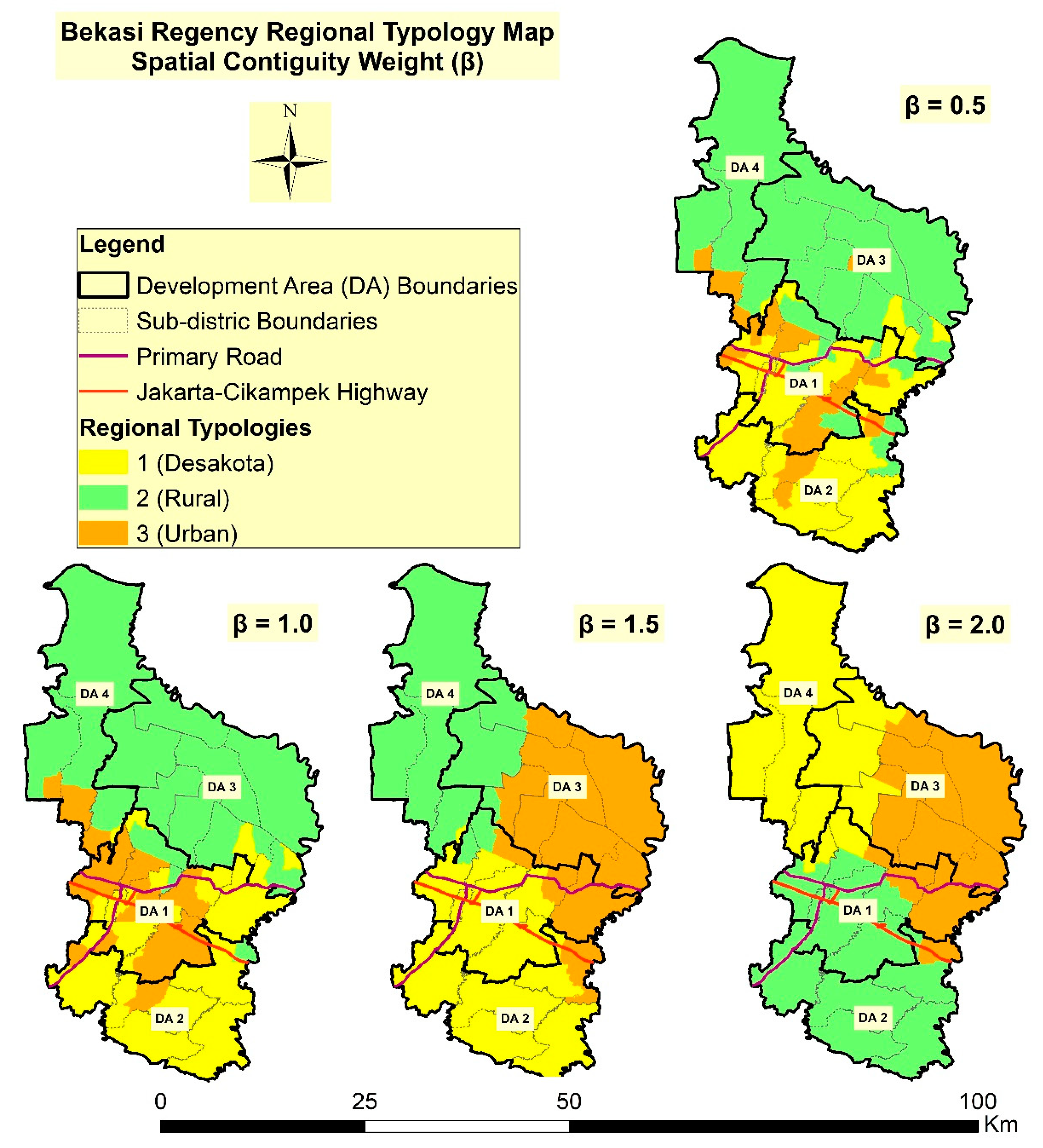
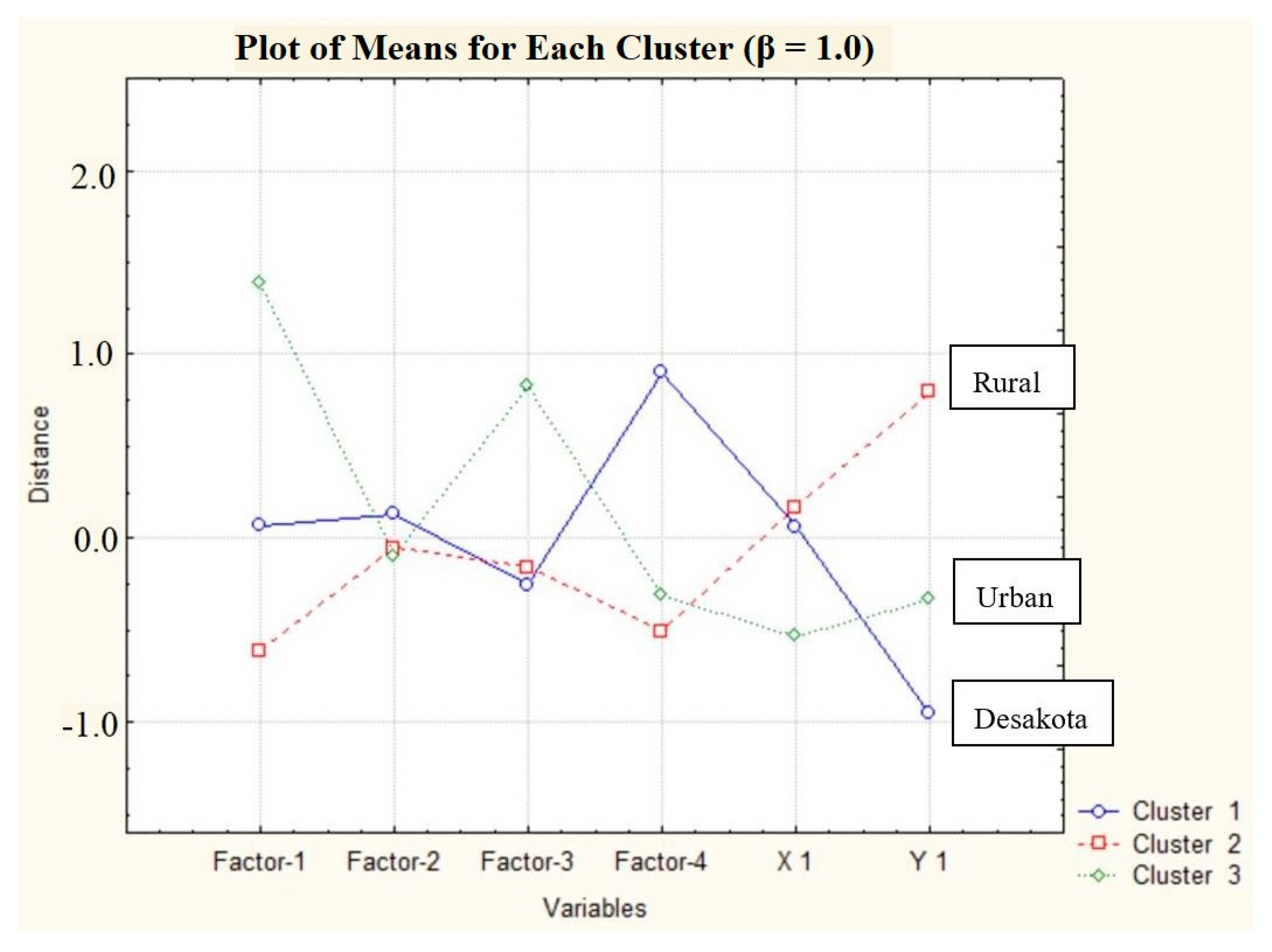
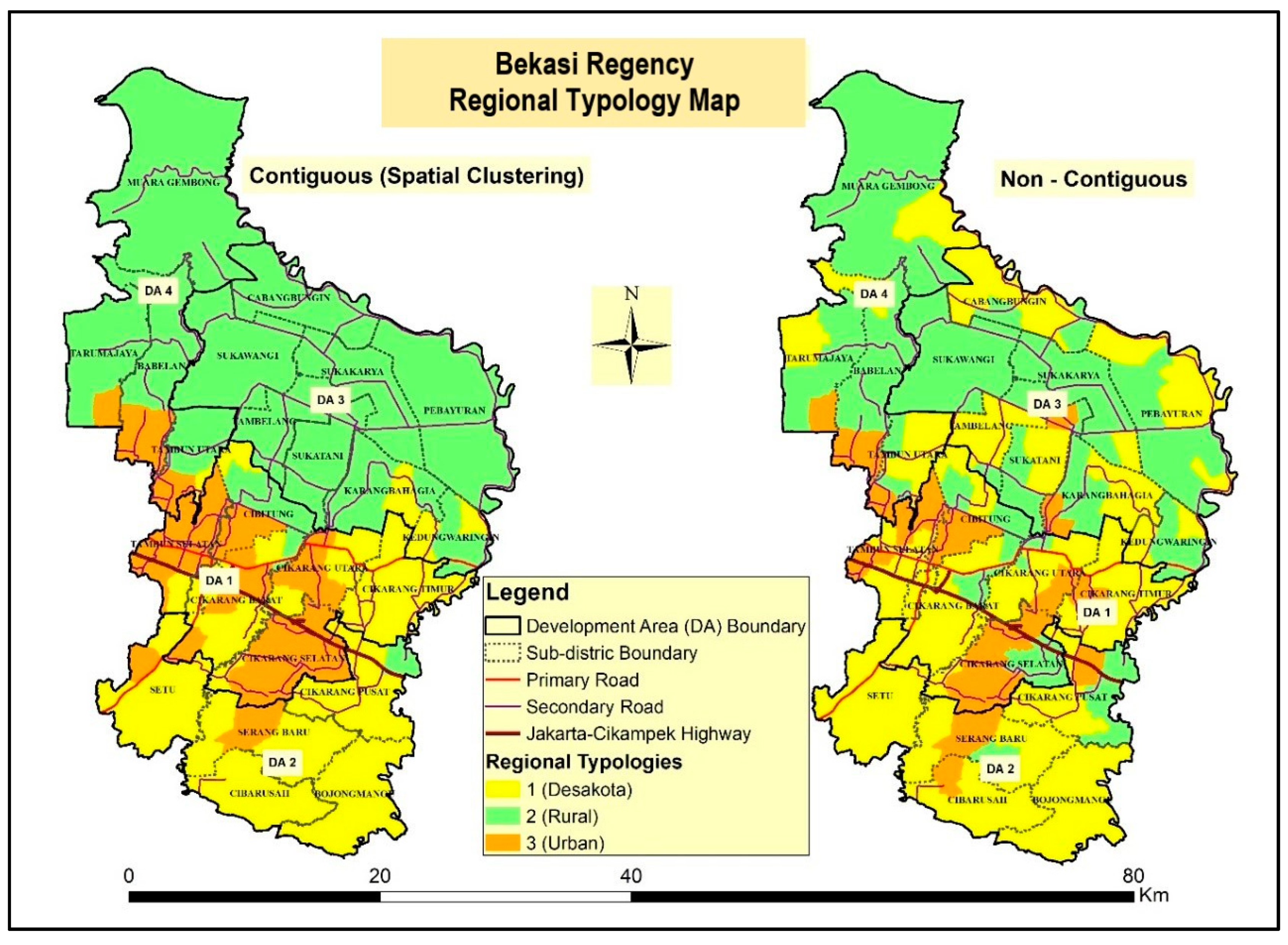
3.2. Regional Typology Using Spatial Clustering Analysis

The regional typology principal in regional development planning is often implemented in the zoning scenario. This implementation functions to facilitate the efficiency of a region’s management to provide a better and more detailed policy and development direction [74]. As a method of determining regional typology, spatial clustering has a function to group regions with similar characteristics and pays attention to spatial proximity [38]. Regional characteristics are described through the values of each factor in each village (spatial unit). In this spatial clustering analysis, three clusters are formed, namely urban, rural, and desakota—a region with a mixture of urban and rural characteristics and is mostly found in metropolitan areas in Indonesia. Determining the selected spatial contiguity weights is based on the lowest coefficient of variation (CV) value [38] and regional contiguity aspects [37]. β = 0.5 is the spatial contiguity weight with the lowest CV value (Table 4). This study uses four spatial contiguity weights, where the maximum weight used is weight two because the weight test has shown that higher weights (β > 1), in this context weights 1.5 and 2, show a high CV, which means that the variation in values in each cluster is very diverse. Varying variations in values within one cluster indicate that the members in the cluster are not homogeneous and that the spatial grouping on these weights is more biased towards proximity or spatial contiguity.
In contrast, viewed from the aspect of contiguity (Figure 5), weight 1 is the best result because there is less fragmentation in each cluster or because it is more compact compared to the 0.5 weight with a smaller contiguity value (Table 4). Based on the CV value and contiguity aspect, weights 0.5 and 1 are the best in describing the typology of the regions in Bekasi Regency. In the aspect of regional development, the delineation of more compact and contiguous regions is the most efficient in terms of management and development [37]. On that basis, weight 1 is the chosen weight to describe the typology of urban–rural in Bekasi Regency because the delineation produced by weight 1 is more compact and contiguous than weight 0.5.

3.3. Characteristics of Each Regional Typology on Bekasi Regency

The cluster division in the spatial clustering analysis is based on the plot of means for each cluster (Figure 6). The characteristics of the mean plot for each cluster are indicated by the degree of difference in the value of each variable. In the plot of the means graph, there is a graph of factors 1–4 (representing the urban–rural characteristics of each cluster) and a graph of the variables X1 and YI (illustrating the spatial/locational characteristics or coordinates of each cluster), where each cluster’s characteristics are represented by the plot of means of each different factor (Figure 6). The translation of graphs for each cluster into urban, rural, and desakota typologies is based on literature studies, especially the zoning concept in Southeast Asia’s peri-urban [5,8,12,14,22,23,37]. Cluster 1 is characterized as a desakota region because it has built-up density at the medium level, highly developed small and medium industries, and has a wider green open space than urban regions. Cluster 2 has characteristics of a rural region, which is characterized by the low level of built-up area and a moderate level of population and socioeconomic development. Cluster 3 has characteristics of an urban region indicated by the conditions of densely built-up areas, high rate of population, and high rate of socioeconomic development. The characteristics of each cluster are presented in Table 5.
The spatial pattern of regional typologies produced by this spatial clustering (contiguous) method is not much different compared to the noncontiguous clustering method, where urban regions are concentrated in DA 1 while rural regions are in DA 3 (Figure 7). The difference is seen in the polygon fragmentation, where in the spatial clustering method, the polygon is more compact and contiguous compared to the noncontiguous clustering method [38]. This difference is the result of spatial variables inclusion (x and y coordinates) so that, for villages that are outliers, the typology will be equated with the surrounding dominant typology [38]. Compact and contiguous zoning is required in regional development policies, in which compact and contiguous areas will be more efficient in its management [37,38,74].
Based on the zoning and characterization results using the spatial clustering method, urban regions are located in DA 1, precisely in the Tambun region (Tambun Selatan, Tambun Utara, and Cibitung subdistrict) and the Cikarang Region (Cikarang Utara, Cikarang Selatan, and Cikarang Barat subdistrict), both containing large industrial and settlements areas. Rural regions are located in almost all subdistricts of DA3 and DA 4, both of which are agricultural areas and mangrove conservation areas [24]. Desakota is a region with mixed characteristics between urban and rural [17], where the typology of this region is spread out in DA 1 and DA 2 surrounding the urban region in Bekasi Regency. Desakota region is often the object of study in the peri-urban development in Southeast Asia because of the different land-use patterns and socioeconomic characteristics compared to peri-urban areas in Europe [22]. Based on literature studies, the desakota region in metropolitan Jakarta is identified as an urban–rural interface area [22], where this area is a direct encounter/interaction between urban and rural land-use. In the case of Bekasi Regency, the development of a desakota region is supported by developing the small and medium industrial area [23,40].

4. Discussion and Conclusions

4.1. The Impact of Suburbanization on Regional Typology

The characteristics of suburbanization in the peri-urban area of Asian metropolitan, especially Southeast Asia, are more due to the process of urban core expansion to the direction of the peri-urban area [10,15]. The process of expansion led to the formation of the Extended Metropolitan Region (EMR) of the metropolitan area in Southeast Asia, especially in the Jakarta Metropolitan Area (JMA), which has been the focus of this study [7,8,9]. Urban core expansion and industrialization processes are the main factors that led to suburbanization in the peri-urban areas of the JMA, especially Bekasi Regency [17,31,40]. Generally, the more continual space of the urban and rural dichotomy was provided in the context of the Extended Metropolitan Region (EMR), where expansion from the large metropolitan core goes into the corridors or spaces between the metropolitan core into a smaller satellite/secondary city [7].
Peri-urban areas in Southeast Asia, especially Bekasi Regency, has high population densities (even in rural regions) and overall mixed land-use nearing the peri-urban areas; a new classification called desakota has emerged to explain this phenomenon [2,11]. This study that characterizes regional typology was formed in Bekasi Regency using the quantitative zoning method (spatial clustering method). The use of the quantitative zoning method in regional typology was formed in an area still rarely used, especially in Indonesia [38,75]. The use of quantitative zoning is beneficial in carrying out the zoning process with many variables and producing zoning that takes into account the spatial contiguity aspect [38].
The results showed that Bekasi Regency has two urban zones, namely the Cikarang region and the Tambun region. The Cikarang region is a large industrial and residential area, while the Tambun region is a settlement expansion from Bekasi City. Apart from experiencing suburbanization due to urban expansion, Bekasi Regency is also experiencing post-suburbanization driven by development of the industrial sector, creating two urban zones in this city [2]. The urban region characteristics of Bekasi Regency are similar to the urban region in Southeast Asia, which is generally dominated by urban land-use coverage, low to no agricultural area, and most developed industrial estates (medium and big industrial area). The urban region in this research is considered adjacent contiguous built-up areas that may extend even outside the core city zone [6,26]. Urban regions have a distinct characteristic where migration and industry flow towards and outwards of this region, resulting in high population density and slum area. Industrial development in this region would not be as massive as other regions due to the already developed industrial estates [11].
The desakota region of Bekasi Regency, which is located between urban and rural regions, is a “chaotic region” where most expansion and suburbanization impact directly on this region, often resulting in “chaotic land-use” if poorly regulated [11]. Agricultural land-use in the desakota region of Bekasi Regency is threatened with land conversion due to the highest industrial development, as most industrial development (regulated or not) happens in this region [2]. This has resulted in the flow of migration and industry towards this region as urban regions have become more saturated and too competitive for new industries to grow and prosper. Rural regions are located in the northern part of Bekasi Regency, have a relatively low urban land-use, and are still dominated by agricultural areas. However, due to the increasing rate of suburbanization and expansion that was headed this way, industrial development and an increase in population and slum areas were inevitable. Rural regions are not the firm region within the mega-urban region context, as this zone could act as the “boundary” of the urban expansion and could limit its expansion [6,26].

4.2. Desakota and Rural Regions Play an Essential Role in Sustainable Development on Bekasi Regency

The suburbanization process in the peri-urban area of the Jakarta Metropolitan Area (JMA), including Bekasi Regency, tends to be unsustainable. The suburbanization process raises a number of sustainability issues, including conversion of agricultural areas to built-up areas [23,24], regional imbalance between urban and rural regions of JMA [23], changes in agrarian structure in the peri-urban area of JMA [76], and spatial and social segregation between the rich and the poor [4,21,25]. Food security is also an issue that needs to be considered in Bekasi Regency because, as a peri-urban agriculture area of JMA, agricultural area tends to be converted into urban area due to the direction of urban physical growth headed into the desakota and rural regions of Bekasi Regency, which will then threaten its agricultural land [22].
Desakota regions act as a resource frontier providing inputs (natural and human capital), especially food security, to be used for urban activities, which might become a severe issue in ecological sustainability if not taken seriously by the government [22,25]. Rural regions in Southeast Asia are often high-productivity rice-growing areas, which then act the same as the desakota region: as a resource provider for maintaining urban activity [6,26]. Maintaining the sustainability of desakota and rural regions as agricultural areas is essential, especially in maintaining ecological balance and food security in Bekasi Regency. The results of this study will help to identify rural and desakota regions that need to be maintained sustainably. Besides, the results of this study can become the basis for typology-based regional development policy so that the sustainability issues in Bekasi Regency can be solved.
Regarding the future development of this research, this research has several weaknesses where the characterization of suburbanization is only based on one-year data, even though suburbanization is a dynamic process. This constraint is due to the very limited village-level temporal data in Indonesia. Further development of the research can be done mainly in the spatial clustering method used, Rustiadi’s spatial clustering method 1, because, at β > 1, spatial proximity aspects become too dominant over other regional characteristics variable. Besides, there needs to be a more precise indicator to assess contiguity aspects such as CV calculation, and there needs to be depth studies of environmental variables that can describe rural–urban transformation in the Southeast Asia region.

Author Contributions

Data collection, conceptualization, field survey conduction, data curation, formal analysis, validation, visualization, and writing—original draft: A.A.K.; investigation, methodology, supervision, validation, writing—review and editing: E.R. and A.E.P. All authors have read and agreed to the published version of the manuscript.

Funding

This research was funded by the Ministry of Research, Technology, and Higher Education, the Republic of Indonesia through the PMDSU scholarship scheme.

Acknowledgments

We would like thanks to Ministry of Research, Technology, and Higher Education, the Republic of Indonesia for funding this research and to all members of the regional development planning laboratory, IPB University, for constructive discussion to perfect this research.

Conflicts of Interest

The authors declare no conflict of interest. The funders had no role in the study; in the collection, analyses, or interpretation of data; in the writing of the manuscript; or in the decision to publish the results.

References

  1. Fong, E.; Shibuya, K. Suburbanization and Home Ownership: The Spatial Assimilation Process in U.S. Metropolitan Areas. Soc. Perspect. 2000, 43, 137–157. [Google Scholar] [CrossRef]
  2. Hudalah, D.; Firman, T. Beyond property: Industrial estates and post-suburban transformation in Jakarta metropolitan region. Cities 2012, 29, 40–48. [Google Scholar] [CrossRef]
  3. Lewis, R.D. Manufacturing Suburbs: Building Work and Home on the Metropolitan Fringe; Temple University Press: Philadelphia, PA, USA, 2004. [Google Scholar]
  4. Firman, T.; Fahmi, F.Z. The Privatization of Metropolitan Jakarta’s (Jabodetabek) Urban Fringes: The Early Stages of “Post-Suburbanization” in Indonesia. J. Am. Plan. Assoc. 2017, 83, 68–79. [Google Scholar] [CrossRef]
  5. Winarso, H.; Hudalah, D.; Firman, T. Peri-urban transformation in the Jakarta metropolitan area. Habitat Int. 2015, 49, 221–229. [Google Scholar] [CrossRef]
  6. Firman, T. The continuity and change in mega-urbanization in Indonesia: A survey of Jakarta–Bandung Region (JBR) development. Habitat Int. 2009, 33, 327–339. [Google Scholar] [CrossRef]
  7. McGee, T.; Greenberg, C. The Emergence of Extended Metropolitan Regions in ASEAN. Asean Econ. Bull. 1992, 9, 10–34. [Google Scholar] [CrossRef]
  8. Douglass, M. Mega-urban Regions and World City Formation: Globalization, the Economic Crisis, and Urban Policy Issues in Pacific Asia. Urban Stud. 2000, 37, 2315–2335. [Google Scholar] [CrossRef]
  9. Hakim, I.; Parolin, B. Spatial Structure and Spatial Impacts of the Jakarta Metropolitan Area: Southeast Asian EMR Perspective. Int. J. Civ. Environ. Eng. 2008, 2, 227–235. [Google Scholar]
  10. McGee, T.; Robinson, I.M. The Mega-Urban Regions of Southeast Asia; University of British Columbia Press: Vancouver, BC, Canada, 1995. [Google Scholar]
  11. McGee, T.; Shahrudin, I. Reimagining the “Peri-Urban” in the Mega-Urban Regions of Southeast Asia. Book of Balanced Urban Development: Options and Strategies for Liveable. Cities 2016, 72, 499–516. [Google Scholar]
  12. McGee, T.G. The Emergence of Desakota Regions in Asia: Expanding a Hypothesis. In The Extended Metropolis: Settlement Transition in Asia; Ginsberg, N., Koppel, B., McGee, T.G., Eds.; University of Hawaii Press: Honolulu, HI, USA, 1991; pp. 3–26. [Google Scholar]
  13. Rustiadi, E.; Pribadi, D.O.; Pravitasari, A.E.; Agrisantika, T. The dynamics of population, economic hegemony and land use/cover change of Jabodetabek Region (Jakarta Megacity). Atlas 2012, 5, 51–56. [Google Scholar]
  14. McGee, T.G. Desakota Termination in the International Encyclopedia of Geography; Douglas, R., Noel, C., Michael, F., Goodchild, A.K., Weidong, L., Richard, A.M., Eds.; John Wiley & Sons Ltd.: Hoboken, NJ, USA, 2017. [Google Scholar]
  15. Dorodjatoen, A.M. The Emergence of Jakarta-Bandung Mega-Urban Region and Its Future Challenges. J. Perenc. Wil. Dan Kota 2009, 20, 15–33. [Google Scholar]
  16. Vioya, A. Tahapan Perkembangan Kawasan Metropolitan Jakarta “Jakarta Metropolitan Area Development Stages”. J. Perenc. Wil. Dan Kota 2010, 21, 215–226. [Google Scholar]
  17. Rustiadi, E.; Panuju, D.R. Spatial pattern of suburbanization and land-use change process: Case study of Jakarta Suburb. In Land-Use Changes in Comparative Perspective; Himiyama, Y., Hwang, M., Ichinose, T., Eds.; Science Publishers: New Hampshire, UK, 2002; pp. 33–52. [Google Scholar]
  18. Indraprahasta, G.S. The potential of urban agriculture development in Jakarta. Procedia Environ. Sci. 2013, 17, 11–19. [Google Scholar] [CrossRef] [Green Version]
  19. Pravitasari, A.E.; Saizen, I.; Tsutsumida, N.; Rustiadi, E.; Pribadi, D.O. Local Spatially Dependent Driving Forces of Urban Expansion in an Emerging Asian Megacity: The Case of Greater Jakarta (Jabodetabek). J. Sustain. Dev. 2015, 8, 108–119. [Google Scholar] [CrossRef] [Green Version]
  20. West Java Statistical Agency. Kabupaten Bekasi Dalam Angka; Bekasi Regency in Figures 2019; West Java Statistical Agency Press: Bandung, Indonesia, 2019.
  21. Firman, T. New town development in Jakarta Metropolitan Region: A perspective of spatial segregation. Habitat Int. 2004, 28, 349–368. [Google Scholar] [CrossRef]
  22. Pribadi, D.O.; Pauleit, S. The dynamics of peri-urban agriculture during rapid urbanization of Jabodetabek Metropolitan Area. Land Use Policy 2015, 48, 13–24. [Google Scholar] [CrossRef]
  23. Pribadi, D.O.; Pauleit, S. Peri-urban agriculture in Jabodetabek Metropolitan Area and its relationship with the urban socioeconomic system. Land Use Policy 2016, 55, 265–274. [Google Scholar] [CrossRef]
  24. Santosa, S.; Rustiadi, E.; Mulyanto, B.; Murtilaksono, K.; Widiatmaka; Rachman, N.F. Modeling on Establishment of Sustainable Paddy Field Zone in Bekasi Regency, Indonesia. J. Environ. Earth Sci. 2015, 5, 79–89. [Google Scholar]
  25. Zhu, J.; Simarmata, H.A. Formal land rights versus informal land rights: Governance for sustainable urbanization in the Jakarta metropolitan region, Indonesia. Land Use Policy 2015, 43, 63–73. [Google Scholar] [CrossRef]
  26. McGee, T. Distinctive Urbanization in the Peri-Urban Regions of East and Southeast Asia: Renewing the Debate. J. Reg. City Plan. 2005, 16, 39–55. [Google Scholar]
  27. Zekovic, S.; Vujosevic, M.; Bolay, J.C.; Cvetinovic, M.; Miljkovic, J.Z.; Maricic, T. Planning and Land Policy Tools for Limiting Urban sprawl: The Example of Belgrade. J. Spatium 2015, 33, 69–75. [Google Scholar] [CrossRef]
  28. Hu, Z.; Wang, Y.; Liu, Y.; Long, H.; Peng, J. Spatio-Temporal Patterns of Urban-Rural Development and Transformation in East of the “Hu Huanyong Line”, China. Int. J. Geo-Inf. 2016, 5, 24. [Google Scholar] [CrossRef] [Green Version]
  29. Nogues, S.; Gonzalez, E.; Cordere, R. Planning regional sustainability: An index-based framework to assess spatial plans. Application to the region of Cantabria (Spain). J. Clean. Prod. 2019, 225, 510–523. [Google Scholar] [CrossRef]
  30. Sodiq, A.; Baloch, A.A.B.; Khan, S.A.; Sezer, N.; Mahmoud, S.; Jama, M.; Abdelaal, A. Towards modern sustainable cities: Review of sustainability principles and trends. J. Clean. Prod. 2019, 227, 972–1001. [Google Scholar] [CrossRef]
  31. Rustiadi, E.; Mizuno, K.; Kobayashi, S. Measuring spatial patterns of the suburbanization process. A case study of Bekasi District, Indonesia. J. Rural Plan Assoc. Jpn. 1999, 18, 31–41. [Google Scholar] [CrossRef]
  32. Petrisor, A.I.; Ianos, I.; Iurea, D.; Vaidianu, M.N. Applications of Principal Component Analysis integrated with GIS. Procedia Environ. Sci. 2012, 14, 247–256. [Google Scholar] [CrossRef] [Green Version]
  33. Yang, W.; Zhao, Y.; Wang, D.; Wu, H.; Lin, A.; He, L. Using Principal Components Analysis and IDW Interpolation to Determine Spatial and Temporal Changes of Surface Water Quality of Xin’anjiang River in Huangshan, China. Int. J. Environ. Res. Public Health 2020, 17, 2942. [Google Scholar] [CrossRef]
  34. Vyas, S.; Kumarayanake, L. Constructing socioeconomic status indices: How to use principal components analysis. Health Policy Plan. 2006, 21, 459–468. [Google Scholar] [CrossRef] [Green Version]
  35. Kellow, J.T. Using Principal Components Analysis in Program Evaluation: Some Practical Considerations. J. Multidiscip. Eval. 2006, 5, 89–107. [Google Scholar]
  36. Tobler, W.A. Computer Movie Simulating Urban Growth in The Detroit Region. Econ. Geogr. 1990, 46, 234–240. [Google Scholar] [CrossRef]
  37. Rustiadi, E.; Saefulhakim, S.; Panuju, D.R. Perencanaan dan Pengembangan Wilayah; Regional Development and Planning, Crespent Press: Bogor, Indonesia, 2018. [Google Scholar]
  38. Rustiadi, E.; Kobayashi, S. Contiguous spatial classification: A new approach on quantitative zoning method. J. Geogr. Educ. 2000, 43, 122–136. [Google Scholar]
  39. Wagistina, S.; Suman, A.; Antariksa, A.; Yanuwiadi, B. Urban Sprawl, Suburbanization, and Informal Sector in Westernern Suburb Area-Malang City-East Java. Wacana 2017, 20, 89–97. [Google Scholar]
  40. Hudalah, D.; Viantara, D.; Firman, T.; Woltjer, J. Industrial land development and manufacturing deconcentration in Greater Jakarta. Urban Geogr. 2013, 34, 950–971. [Google Scholar] [CrossRef]
  41. Rustiadi, E.; Pribadi, D.O.; Pravitasari, A.E.; Indraprahasta, G.S.; Iman, L.S. Jabodetabek megacity: From city development toward urban complex management system. In Urban Development Challenges, Risks and Resilience in Asian Mega Cities; Springer: Berlin, Germany, 2015; pp. 421–445. [Google Scholar]
  42. Zivanovic, V. The Role of Nodal Centers in Achieving Balanced Regional Development. J. Geogr. Inst. Cvijic 2017, 67, 69–84. [Google Scholar] [CrossRef]
  43. Kurnia, A.A.; Rustiadi, E.; Pravitasari, A.E. Cluster Analysis and Spatial Pattern Approaches in Identifying Development Pattern of Bodebek Region, West Java. Proc. SPIE 11372. In Proceedings of the Sixth International Symposium on LAPAN-IPB Satellite, Bogor, Indonesia, 24 December 2019. [Google Scholar]
  44. Tacoli, C.; Mabala, R. Exploring mobility and migration in the context of rural—Urban linkages: Why gender and generation matter. Environ. Urban. 2010, 22, 389–395. [Google Scholar] [CrossRef]
  45. Zuberi, D.; Ivemark, B.; Ptashnick, M. Lagging behind in suburbia: Suburban versus urban newcomers’ employment settlement service outcomes in Metro Vancouver, Canada. Soc. Sci. J. 2018, 55, 443–454. [Google Scholar] [CrossRef]
  46. Long, H.L.; Heilig, G.K.; Li, X.B.; Zhang, M. Socio-economic development and land-use change: Analysis of rural housing land transition in the Transect of Yangtze River, China. Land Use Policy 2007, 24, 141–153. [Google Scholar] [CrossRef]
  47. Long, H.L.; Liu, Y.Q.; Hou, X.G.; Li, T.T.; Li, Y.R. Effects of land use transitions due to rapid urbanization on ecosystem services: Implications for urban planning in the new developing area of China. Habitat Int. 2014, 44, 536–544. [Google Scholar] [CrossRef]
  48. Cui, X.; Li, S.; Wang, X.; Xue, X. Driving factors of urban land growth in Guangzhou and its implications for sustainable development. Front. Earth Sci. 2018, 13, 464–477. [Google Scholar] [CrossRef]
  49. Inwood, S.M.; Sharp, J.S. Farm persistence and adaptation at the rural-urban interface: Succession and farm adjustment. J. Rural Stud. 2011, 27, 107–117. [Google Scholar] [CrossRef]
  50. Kalnay, E.; Chai, M. Impact of urbanization and land use on climate change. Nature 2003, 423, 528–531. [Google Scholar] [CrossRef] [PubMed]
  51. Dou, H.Y.; Zhao, X.Y. Climate change and its human dimensions based on GIS and meteorological statistics in Pearl River Delta, Southern China. J. Meteorol. Appl. 2010, 18, 111–122. [Google Scholar] [CrossRef]
  52. Yao, X.; Wang, Z.; Wang, H. Impact of Urbanization and Land-Use Change on Surface Climate in Middle and Lower Reaches of the Yangtze River, 1988–2008. J. Adv. Meteorol. 2015, 2015, 395094. [Google Scholar] [CrossRef] [Green Version]
  53. Lin, J.; Lei, J.; Yang, Z.; Li, J. Differentiation of Rural Development Driven by Natural Environment and Urbanization: A Case Study of Kashgar Region, Northwest China. Sustainability 2019, 11, 6859. [Google Scholar] [CrossRef] [Green Version]
  54. Patra, S.; Sahoo, S.; Wu, H.; Jiao, H.; Yu, Y.; Zhao, J. Impacts of urbanization on land use/cover changes and its probable implications on local climate and groundwater level. J. Urban Manag. 2018, 7, 70–84. [Google Scholar] [CrossRef]
  55. Pengjun, Z.; Shengxiao, L. Suburbanization, land use of TOD and lifestyle mobility in the suburbs: An examination of passengers’ choice to live, shop and entertain in the metro station areas of Beijing. J. Transp. Land-Use 2018, 11, 195–215. [Google Scholar] [CrossRef]
  56. Mesjasz-Lech, A.; Szczepańska, A. Development of Suburbanization in the Context of Socioeconomic Changes in Urban Areas on the Example of Poland. In Proceedings of the 11th International Conference on Mangement, Enterprise and Benchmarking (MEB 2015), Óbuda University, Keleti Faculty of Business and Management, Budapest, Hungary, 29–30 May 2015. [Google Scholar]
  57. Hermelin, B. The Urbanization and Suburbanization of the Service Economy: Producer Services and Specialization in Stockholm. Geogr. Ann. Ser. BHum. Geogr. 2007, 89, 59–74. [Google Scholar] [CrossRef]
  58. Shen, J.; Wu, F. The Suburb as a Space of Capital Accumulation: The Development of New Towns in Shanghai, China. Antipode 2017, 49, 761–780. [Google Scholar] [CrossRef]
  59. Wang, H.; Shi, Y.; Zhang, A.; Cao, Y.; Liu, H. Does Suburbanization Cause Ecological Deterioration? An Empirical Analysis of Shanghai, China. Sustainability 2017, 9, 124. [Google Scholar] [CrossRef] [Green Version]
  60. Li, C.; Bingyu, W. Principal Components Analysis. Available online: http://www.ccs.neu.edu/home/vip/teach/MLcourse/5_features_dimensions/lecture_notes/PCA/PCA.pdf (accessed on 2 May 2020).
  61. Jolliffe, I.T. Principal Component Analysis; Springer: London, UK, 2002. [Google Scholar]
  62. Li, X.; Yeh, G.O. Urban Simulation Using Principal Components Analysis and Cellular Automata for Land-Use Planning. Photogramm. Eng. Remote Sens. 2002, 68, 341–351. [Google Scholar]
  63. Sabatini, M.C.; Verdiel, A.; Rodriguez, R.M.; Vidal, I.M. A Quantitative Method for Zoning of Protected Areas and its Spatial Ecological Implications. J. Environ. Manag. 2007, 83, 198–206. [Google Scholar] [CrossRef] [PubMed]
  64. Lee, G.G.; Kim, M.S.; Lee, H.J.; Kim, J.J. Zoning management by quantitative landscape assessment for forest pathway—The case of forest paths of the Mt. Jiri national park, South Korea. For. Sci. Technol. 2014, 4, 179–189. [Google Scholar] [CrossRef] [Green Version]
  65. Kianisadr, M.; Darani, K.M.; Golkarian, H. Quantitative Zoning of Ecotourism Potential in Oshtorankouh Protected Area Using Delphi Method, Analytic Hierarchy Process, and Weighted Overlay Methods. Ecopersia 2019, 7, 115–123. [Google Scholar]
  66. Ester, M.; Frommelt, A.; Kriegel, H.P.; Sander, J. Algorithms for characterization and trend detection in spatial databases. In Proceedings of the International Conference on Knowledge Discovery and Data Mining, New York, NY, USA, 27–31 August 1998. [Google Scholar]
  67. Tan, P.N.; Steinbach, M.; Karpatne, A.; Kumar, V. Introduction to Data Mining; Pearson: New York, NY, USA, 2013. [Google Scholar]
  68. Varghese, B.M.; Unnikrishnan, A.; Paulouse, J.K. Spatial Clustering Algorithms—An Overview. Asian J. Comput. Sci. Inf. Technol. 2013, 3, 1–8. [Google Scholar]
  69. Ducret, R.; Lemarie, B.; Roset, A. Cluster analysis and spatial modeling for urban freight. Identifying homogeneous urban zones based on urban form and logistics characteristics. Transp. Res. Procedia 2016, 12, 301–313. [Google Scholar] [CrossRef] [Green Version]
  70. Zhu, J.; Sun, Y. Building an Urban Spatial Structure from Urban Land Use Data: An Example Using Automated Recognition of the City Centre. Int. J. Geo-Inf. 2017, 6, 122. [Google Scholar] [CrossRef] [Green Version]
  71. Kirschenbaum, A. Spatial Clustering, Segregation and Urban Planning: A methodological approach. Urban Stud. 1974, 11, 323–327. [Google Scholar] [CrossRef]
  72. Liu, L.; Peng, Z.; Wu, H.; Jiao, H.; Yu, Y.; Zhao, J. Fast Identification of Urban Sprawl Based on K-Means Clustering with Population Density and Local Spatial Entropy. Sustainability 2018, 10, 2683. [Google Scholar] [CrossRef] [Green Version]
  73. Pribadi, D.O.; Rustiadi, E.; Panuju, D.R.; Pravitasari, A.E. Permodelan Perencanaan Pengembangan Wilayah: Konsep, Metode, Aplikasi dan Teknik Komputasi; Regional Development Planning Modelling: Concept, Method, Application and Computation Technic; Crespent Press: Bogor, Indonesia, 2018. [Google Scholar]
  74. Silva, E.A.; Acheampong, R.A. Developing an Inventory and Typology of Land-Use Planning Systems and Policy Instruments in OECD Countries. Oecd Environ. Work. Pap. 2015, 94, 1–52. [Google Scholar]
  75. Pravitasari, A.E.; Saizen, I.; Rustiadi, E. Towards Resilience of Jabodetabek Megacity: Developing Local Sustainability Index with Considering Local Spatial Interdependency. Int. J. Sustain. Future Hum. Secur. 2016, 4, 27–34. [Google Scholar] [CrossRef]
  76. Pribadi, D.O.; Zasada, I.; Muller, K.; Pauleit, S. Multifunctional adaption of farmers as response to urban growth in the Jabodetabek Metropolitan Area, Indonesia. J. Rural Stud. 2017, 55, 100–111. [Google Scholar] [CrossRef]
Figure 1. Research framework.
Sustainability 12 08094 g001
Figure 2. Research area location (Bekasi Regeny in the Jakarta Metropolitan Area (JMA)).
Sustainability 12 08094 g002
Figure 3. Bekasi Regency spatial planning map.
Sustainability 12 08094 g003
Figure 4. Spatial patterns of each factor value in each spatial unit (village).
Sustainability 12 08094 g004
Figure 5. Map of regional typology on each spatial contiguity weight.
Sustainability 12 08094 g005
Figure 6. The plot of means for each regional typology.
Sustainability 12 08094 g006
Figure 7. Comparison of Contiguous and Non-Contiguous Method on Bekasi Regency Regional Typologies.
Sustainability 12 08094 g007
Table 1. Variables of every aspect of urban–rural development.
CodeVariablesAspectRelationship on
URD
L1Vegetation density indexEnvironment+
L2Percentage of the family who does not live in
the river bank
Environment+
I1Percentage of large-scale industrial areaIndustry+
I2Number of small- and medium-scale industriesIndustry+
I3The ratio of small- and medium-scale industries to the total populationIndustry-
K1Population densityPopulation+
K2Proportion of village population to
subdistrict population
Population+
K3Population growth ratePopulation+
S1The ratio of population unaffected by diarrhea to total populationSocio-Economic+
S2The ratio of families who do not live in a slum area to total of familiesSocio-Economic+
P1Percentage of built-up areaLand-Use+
P2Percentage of non-paddy field areaLand-Use+
P3Percentage of settlement areaLand-Use+
Table 2. Factor analysis results using Principal Component Analysis (PCA) (factor loading).
VariableFactor 1Factor 2Factor 3Factor 4
K20.050.040.85−0.06
K3−0.05−0.130.790.01
L1−0.040.16−0.110.74
L20.08−0.130.050.79
S10.540.030.74−0.11
S20.400.040.770.05
P10.88−0.070.280.04
P20.860.04−0.07−0.04
P30.94−0.010.230.08
I20.100.940.15−0.03
I3−0.110.93−0.190.08
Eigenvalue3.961.851.631.17
% Total variance35.9716.7814.8210.67
Cumulative Eigenvalue3.965.807.438.61
Cumulative %35.9752.7567.5778.24
Table 3. Eigenvalue score on each factor.
FactorsVariablesEigenvalue Score
Factor 1 (Urban land-use)Percentage of built-up area (P1)
Percentage of non-paddy field area (P2)
Percentage of settlement area (P3)
3.96
Factor 2 (Medium-scale
industrial development)
Number of small and medium scale industries (I2)
The ratio of small and medium scale industries to the total population (I3)
1.85
Factor 3 (Population and socioeconomic development)The proportion of village population to subdistrict population (K2)
Population growth rate (K3)
The ratio of population unaffected by diarrhea to total population (S1)
The ratio of families who do not live in a slum area to total of families (S3)
1.63
Factor 4 (Environmental quality)Percentage of the family who does not live in the river bank (L3)
Vegetation density index (L1)
1.17
Table 4. Coefficient of Variance (CV) and contiguity (K) values of each weight in each cluster region.
ClusterThe CV Value for Weight 0.5The CV Value for Weight 1The CV Value for Weight 1.5The CV Value for Weight 2
Cluster 158.7645.2041.1142.68
Cluster 255.2052.3661.2733.38
Cluster 354.2452.0130.1630.75
Mean56.0749.8644.1835.60
St Dev1.953.3012.895.12
CV3.476.6129.1714.38
Contiguity
Value (K)
10833
Table 5. Characteristics of each regional typology on Bekasi Regency.
ClusterFactor 1
(Urban Land-Use)
Factor 2 (Medium-Scale Industrial Development)Factor 3 (Population and Socioeconomic Development)Factor 4
(Environmental Quality)
1 (Desakota)MediumHighMediumHigh
2 (Rural)LowMediumMediumLow
3 (Urban)HighMediumHighMedium

