The Valuation of Idle Real Estate in Rural Areas: Analysis and Territorial Strategies


Department of Civil, Environmental, Architectural Engineering and Mathematics, Università degli Studi di Brescia (IT), 25123 Brescia, Italy
Sustainability 2020, 12(19), 8240; https://0-doi-org.brum.beds.ac.uk/10.3390/su12198240
Submission received: 17 September 2020
/
Revised: 29 September 2020
/
Accepted: 3 October 2020
/
Published: 7 October 2020
(This article belongs to the Special Issue Rural and Urban Management: Innovative Strategies to Enhance Resilience)
Abstract
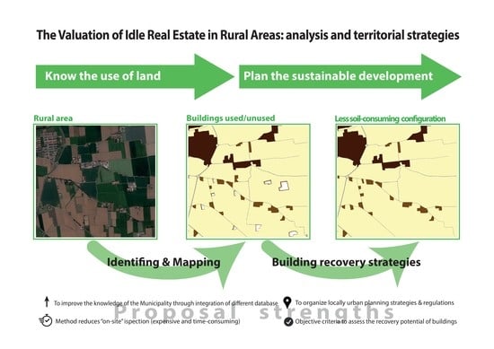
:Knowledge of the environment and its weaknesses is the first step in addressing urban development in a more sustainable direction, seeking, for example, to limit the occupation of new land. This research presents a methodology for identifying unused buildings in rural areas and providing strategies for the recovery and reuse of building heritage. The reuse of idle buildings, which are numerous and widespread in Italian agricultural areas, represents a valid opportunity to contain land occupation, redevelop unused areas (often degraded) and develop employment opportunities and social dynamics (as in the case of nonresidential use). The paper defines an expeditious methodology for the identification and subsequent mapping, on a municipal scale, of the unused building heritage that is external to the consolidated urban fabric. The initial data from a case study for the municipality of Chiari (in Italy) are significant: more than 370 unused real estate structures were identified. A successive analysis identified the individual buildings that were completely unused and proposes an assessment of their potential recovery value. This methodology can be useful for directing municipal urban planning strategies and regulations for the recovery of buildings in rural areas and for environmentally acceptable land utilization.
1. Introduction
The term “abandoned building heritage” can be used to illustrate numerous conditions of land or building inactivity: large abandoned and sometimes contaminated industrial areas, uninhabited residential buildings dispersed over the municipality, large buildings that have lost their functionality (service or recreational) or agricultural areas that no longer perform their function and are left abandoned. This universe of non-use was well illustrated, for example, by Garda and Gambazza [1].
The management of building recovery, in a broad sense, is the responsibility of various organizations. Focusing on the possibilities of local public administrations, knowledge of the phenomenon is the starting point for implementing actions to solve the problem, but this knowledge is not always readably available. Small and medium-small municipalities do not always have the resources (economic, technical and personnel) to carry out supplementary analyses in addition to the “classic” ones foreseen by the drafting of urban plans.
However, to better manage their municipality, the administrators should be in a position to identify unused areas: for large industrial production activities, the information is well-known and available, but for individual buildings or real estate units, the knowledge is not immediately available. In historical centers or in the most populated areas, “empty” buildings are visible to an observant eye, but in rural or agricultural environments, the research becomes more complicated.
In Italy’s rural areas, the use of buildings can be for agricultural production, secondary production, residential—even of small dimensions (small houses or farmers’ residences)—or holiday accommodation.
The analysis of these small empty buildings is the first step in their recovery and to help optimize and contain land use and occupation. The problems caused by urban development are intensely investigated, but the solutions are not as widespread and focus on cities [2,3,4,5,6,7,8,9]. The redevelopment of existing idle buildings—also in the rural area—could be a valid solution in the reduction of free land urbanization and make existing areas newly attractive. It would also reduce the social and environmental risks originating from the presence of degraded areas, would improve the landscape and its perception and generate new jobs in nonresidential areas.
The search for international literature (Web of Science limiting research of the following categories: architecture, civil engineering, environmental engineering, environmental science, environmental studies, green sustainable science technology, multidisciplinary humanities, regional urban planning, social science interdisciplinarity and urban studies) that deals with the very specific case of unused buildings in the rural area by combining the terms “unused/decommissioned/empty” with “building/fabric” in “rural area” or “agricultural area” has not produced appreciable results for its specificity and demonstrates the originality of the theme proposed in this paper. The very few articles that can be identified on the topic (36) deal with similar topics, but from a completely different point of view to the one being investigated:
There have also been studies on the city–countryside relationship, but they are not completely relevant to the present paper’s focus [26,27,28].
The search for contributions in the Italian national literature (the result of a bibliographic research in the indexed search engine of the publisher Franco Angeli was considered for the terms “edifici AND dismessi OR inutilizzati AND agricolo OR rurale”, which resulted in 39 contributions, of which 12 were not relevant. The useful contributions are described in the text), similarly to the international cases, presents for the most part papers of similar themes, but not focused on identifying the abandoned building heritage in rural areas. They discuss:
Entering into the details of some of the contributions identified, we believe that there are some terminological analogies between the present study and that of Garda and Gambazza [1], which deals with abandoned small-scale buildings characterized by functional autonomy (micro-abandonment) but focuses on abandoned commercial spaces within a neighborhood, and which illustrates the extreme variability of the phenomena of abandonment present on the Italian territory and their “taxonomy”. It does not, however, specify a particular methodology for the survey of the commercial spaces under investigation, which could be carried out utilizing the official sources available regarding commercial activities within a city neighborhood.
Treu’s contribution [66] focuses instead on the reasons why it is important to protect and enhance agricultural areas and how this issue is not only a function of urban planning tools and sector policies. The issue of land consumption and its link with the reduction of the area and quality of the agricultural area is certainly the fil rouge of the paper, which also highlights the problems, policies and tools of plans associated with rural management. The paper does not deal with abandoned buildings, but with the generalities of the rural area.
Galdini’s contribution [67], on the other hand, actually deals with urban voids, meant as unused areas of the city (in particular in some metropolises). He proposes solutions for their temporary redevelopment with the involvement of citizens. This allows them to regain possession of these places with renewed, accessible functions that respond effectively to their social needs. Again, we are dealing with the theme of buildings or open spaces abandoned within the city (not in the rural area, as is the focus of the present study).
From the bibliographic analysis presented, a gap in the literature is evident. It is therefore believed that the investigation proposed in this paper is rather original and, as indicated, useful and of value for local governance activities.
In Italy, medium-small municipalities in terms of population and not necessarily in terms of territorial extension generally do not have many resources to invest in urban surveys. Inspections to verify the phenomena “on-site” are very expensive and time-consuming activities that are not always within their capabilities. With the method proposed, local administrations would be able to exploit a tool that maximizes the knowledge already in their possession, integrate it into open-source knowledge and minimize the need for on-site inspections. Thanks to the information obtained from this method, which permits the identification of all buildings and real estate units abandoned in the rural area, it will be possible to better organize urban planning strategies and regulations aimed at the recovery or demolition of buildings based on efficiency criteria for single buildings and their positions.
2. Materials and Methods: Methodology to Identify Unused Buildings in Rural Areas
2.1. Identification of Unused Buildings in Rural Areas
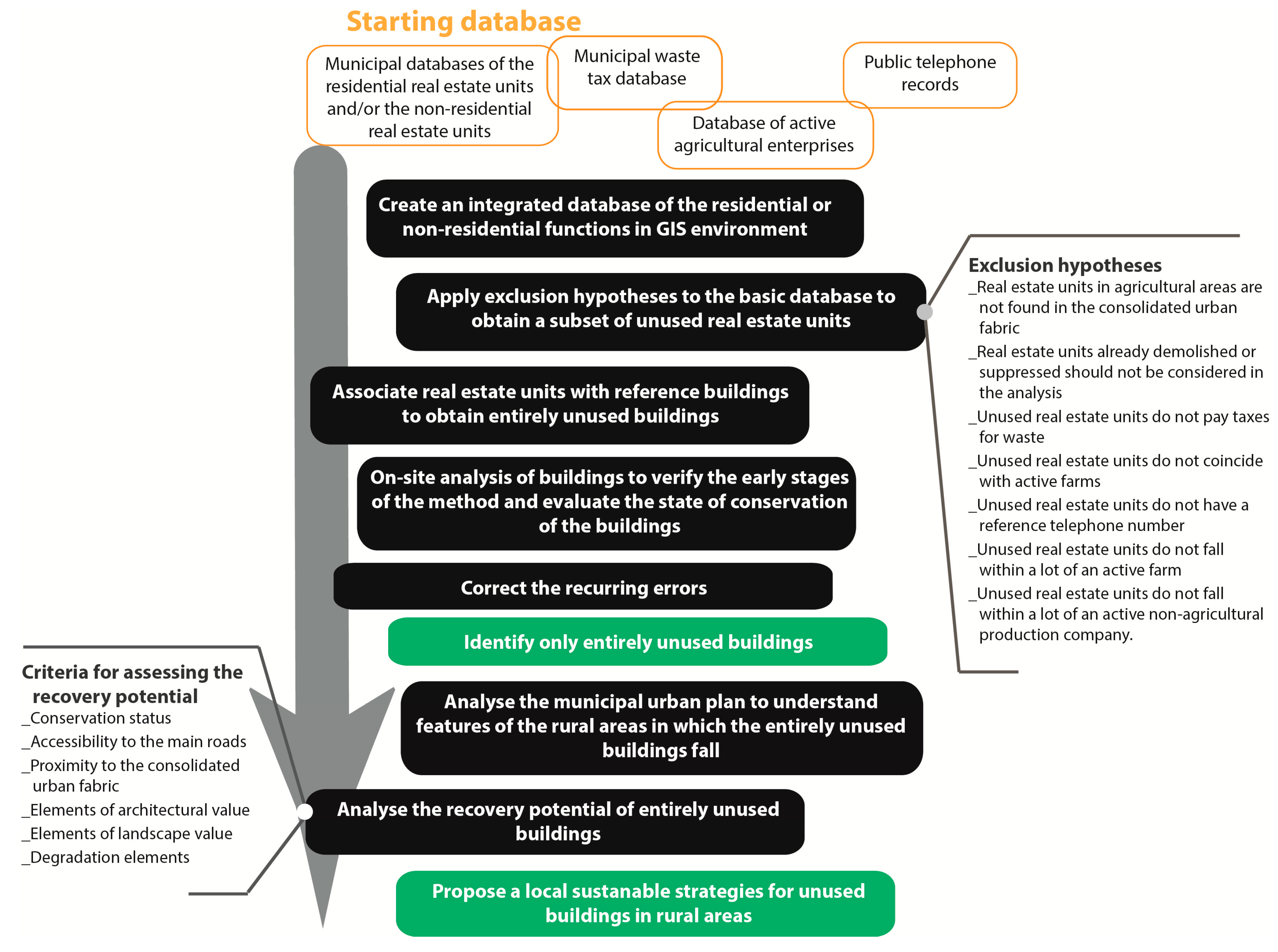
The objective of this method is the identification of unused real estate units and of entirely unused buildings in rural areas. It is based on six different database identities that can be correlated with each other and the supporting information contained in municipal urban plans (in Italy).
The correlation between the databases is possible thanks to the use of the land register database (owned by the municipality), which associates a unique code ("ecografico" code) with each real estate unit in both tabular and cartographic form (Geographic Information System environment). This reference allows the integration of all the available databases and, for subsequent steps, distinguishing between and mapping used and idle real estate units. The six electronic databases necessary for the analysis are:
- The municipal databases of the unused residential real estate units (if available, alternatively the entire one) (cadastre database).
- The municipal databases of the non-residential real estate units (if available, alternatively the entire one) (cadastre database).
- The municipal waste tax database.
- The database of active agricultural enterprises (provided by the regional health protection agency).
- Public telephone records.
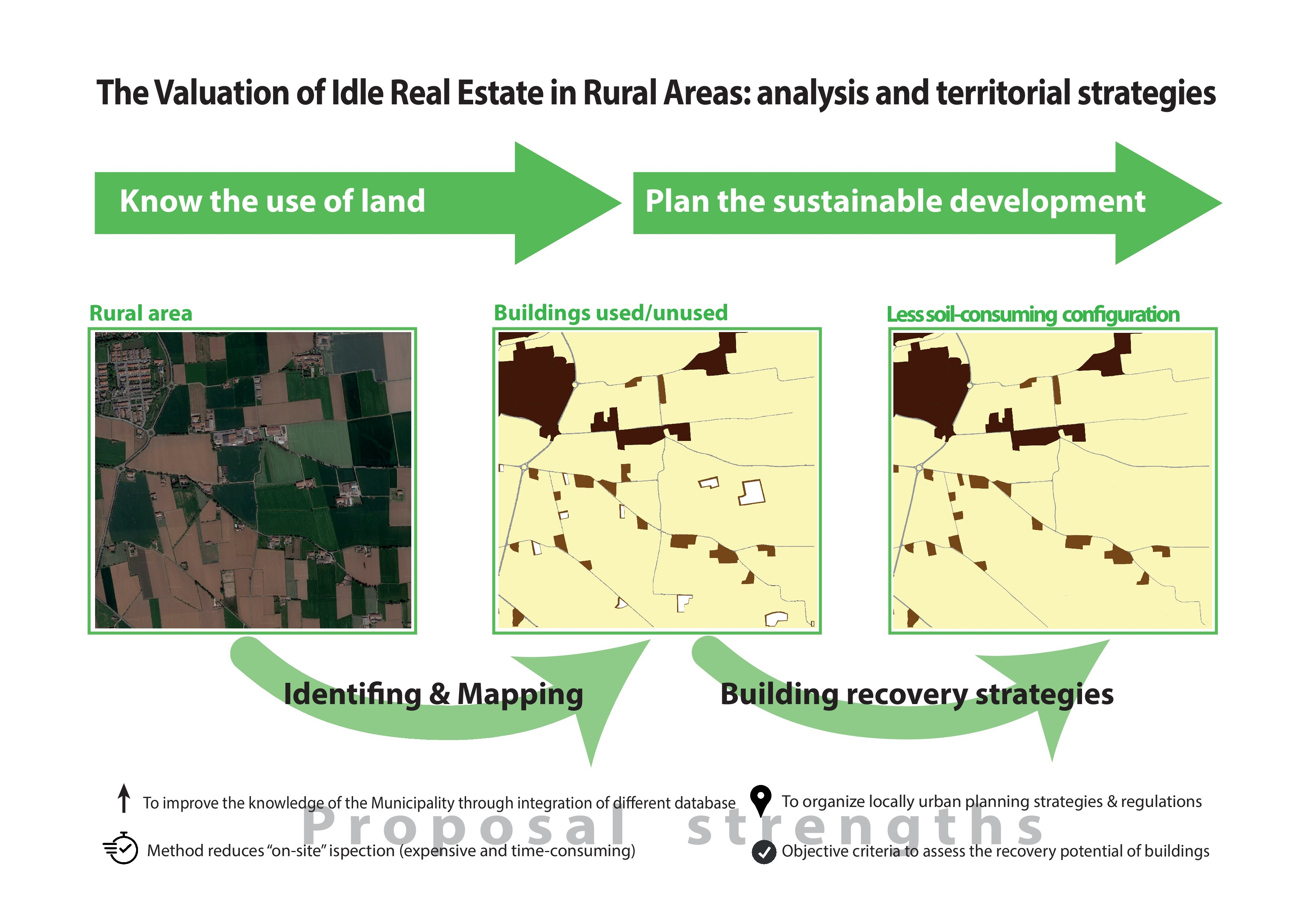
The methodology is structured in several successive phases (Figure 1):
- The development of an integrated database with all the data available for the residential or non-residential functions (table and map) utilizing a GIS (Geographic Information System) software.
- The application of exclusion hypotheses to the basic database so as to obtain a subset of unused real estate units.
- The association of real estate units with reference buildings to obtain entirely unused buildings.
- On-site analysis of only partially and entirely unused buildings to verify the early stages of the method and evaluate the state of conservation of the buildings.
- Elimination of recurring errors that emerged from the previous phase and identification of only entirely unused buildings.
- Analysis of the municipal urban plan to understand typology, characteristics and reference standards of the rural areas in which the entirely unused buildings fall.
- Analysis of the recovery potential of entirely unused buildings to propose local strategies.
The initial phase of the method involves the progressive elimination from the starting database of the definitely occupied or used real estate units that are therefore not included in the final database. This elimination is based on a series of consequential hypotheses:
- Real estate units in agricultural areas are not found in the consolidated urban fabric (Land on which the construction or transformation of the site has already taken place, including freely enclosed or completed areas);
- Real estate units already demolished or suppressed should not be considered in the analysis;
- Unused real estate units do not pay taxes for waste;
- Unused real estate units do not coincide with active farms;
- Unused real estate units do not have a reference telephone number;
- Unused real estate units do not fall within a lot of an active farm;
- Unused real estate units do not fall within a lot of an active non-agricultural production company.
Through the progressive elimination of data that do not satisfy these hypotheses, it is possible to identify the unused real estate units in rural areas. The residential or non-residential function is identified upstream of the analysis using the residential or the non-residential real estate unit’s database subjected to the exclusion hypotheses.
The next phase (3) of the analysis method involves the association of the real estate units with the reference buildings to identify entirely unused buildings. If the building coincides with only one real estate unit, identification is immediate. If there are multiple real estate units in a building, three cases may arise:
- All real estate units are used—then the building is fully used.
- Only some real estate units are used—then the building is partially used.
- All the real estate units are not used—then the building is entirely unused.
The latter case is the only one useful for achieving the goal of the analysis.
To evaluate the cases in which the real estate units (with point data format) fall within the same building and therefore in the same lot (with polygon data format) the cartographic representation (with GIS software) of both contents is exploited. By mapping the used and unused real estate units separately, it is possible to visually evaluate when all the real estate units fall within the same building.
The subsequent on-site check, phase 4, allows to verify the correctness of the exclusion hypotheses utilized in the first part of the method and also the correctness of the municipal land register database on a limited sample (only completely unused buildings). The correspondence between the real estate unit and the building is linked to the internal apartment number and the house number. A building can have a single apartment number and a single house number, several apartment numbers and a single house number, or more than one house number.
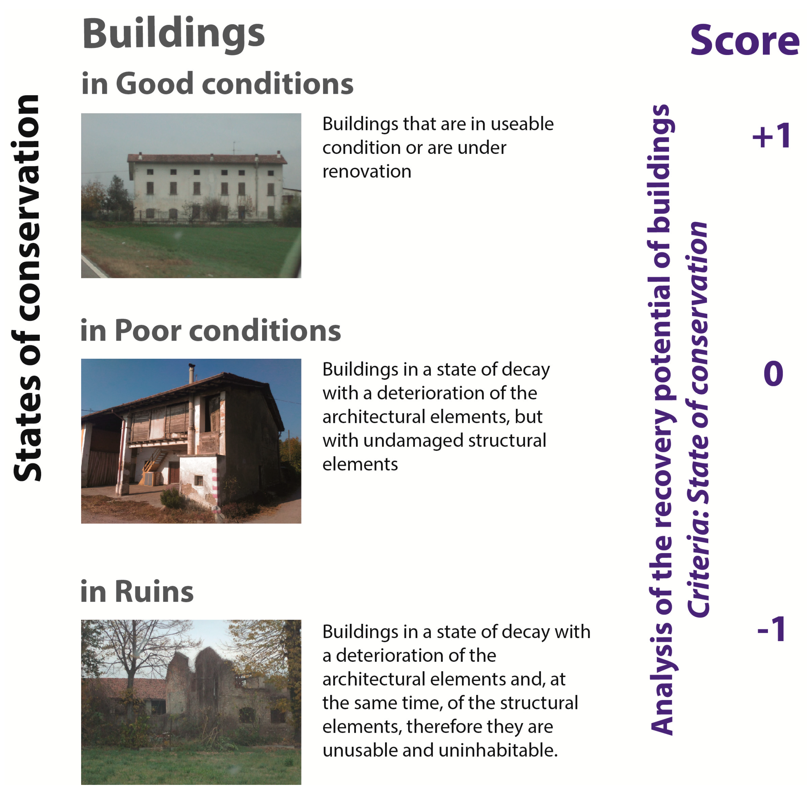
The on-site analysis also permits an easy assessment of the state of conservation of the buildings. Unused buildings can be classified as:
- Ruins (buildings in a state of decay with a deterioration of the architectural elements and, at the same time, of the structural elements; therefore they are unusable and uninhabitable).
- In poor condition (buildings in a state of decay with a deterioration of the architectural elements, but with undamaged structural elements).
- In good condition (buildings that are in useable condition or are under renovation).
The on-site analysis can also help identify any material errors in the databases or in the hypotheses of the method (phase 5).
The next phase (6) of the method involves analyzing the municipal urban plan to understand what land uses and rules are envisaged in rural areas where there are unused buildings.
The last phase (7) provides for the analysis of the recovery potential of entirely unused buildings to propose local strategies.
2.2. Analysis of the Recovery Potential of Entirely Unused Buildings
The analysis uses objective criteria to make the assessment and assigns a score to each building.
The six independent criteria for assessing the recovery potential of unused buildings are:
- Conservation status;
- Accessibility to main roads;
- Proximity to the consolidated urban fabric;
- Elements of architectural value;
- Elements of landscape value;
- Degradation elements.
The state of conservation is assessed thanks to the on-site analysis, carried out under part 4 of the method. In particular, the score for these criteria is:
- −1: buildings in ruins;
- 0: buildings in poor condition;
- 1: buildings in good condition.
States of conservation and relative scores, descriptions of the state of conservation and suggestive images are shown in Figure 2.
Accessibility to main roads is assessed with a score of 1 if the unused building lot is adjacent to a main road or 500 m from a motorway exit, or the entrance to a principal or minor rural arterial roads, or high-traffic roads (such as freeways). The score is 0 if it does not meet any of these conditions.
The proximity to the consolidated urban fabric is assessed based on the land uses for agricultural and rural areas as indicated by the municipal urban plan. The land use closest to the consolidated urban fabric is identified, typically in Italy, as "safeguard" or "protection"; a score of 1 is assigned if the unused building falls in this area while the score is equal to 0 if the unused building is adjacent to this area and equal to −1 in all other cases.
The elements examined for determining the architectural value of the buildings are identified using the municipal landscape plan attached to the urban plan. This document defines for each building historical and architectural features and the presence of significant, constructive and decorative elements, and attributes a value based on the relationship within the overall context. For each building, the significant architectural elements are indicated, including, for example: arches, vaults, columns, ancient courtyards, portals, porticoes, tiled roofs, decorations, pictorial decorations, dovecote towers, etc.—a value of 1 is assigned for the presence of one of the elements of architectural value, and otherwise 0 is assigned.
The landscape value of the area surrounding the unused building is assessed based on the presence of natural elements or areas of environmental and ecological value. Areas of environmental and ecological value have been defined as:
- Areas of high perceptual value, characterized by the presence of physical, environmental and/or historical-cultural factors that determine the overall quality. These areas play an essential role in recognizing the system of historical and cultural heritage and settlement permanence, as well as in safeguarding highly significant landscapes. (Sources: municipal urban plan, landscape component).
- Itineraries with a landscape value. (sources: municipal urban plan, landscape component).
- Cycle paths. Soft mobility is an important element for the establishment of both tourist and residential functions and similar services for the community.
- Areas of archaeological value. These are considered points of interest and value for any future residences or accommodation activities.
- Restricted areas bordering minor watercourses and wooded areas.
- Restricted areas (250 m) surrounding scattered settlements of ancient formation of historical and environmental interest. These areas above all identify small urban agglomerations of historical interest (source: municipal urban plan).
- Areas of environmental landscape protection and ecological value (source: municipal urban plan).
If the unused building falls into one of these areas or is close to (visible from) a valuable element, 1 point is awarded. If there are no elements of landscape value, the score is 0.
The last element investigated to assess the recovery potential of unused buildings is the presence of deterioration elements. The presence of the buildings within the following degradation areas was therefore assessed:
- Restricted areas bordering a motorway (250 m), implying the presence of the motorway but without access;
- Restricted areas surrounding quarries and landfills (200 m);
- Restricted areas for active breeding farms. The dimensions of the buffer zones for breeding are variable according to the number of animals, regulated by hygiene regulations. The municipal urban plan can derogate these bands only under certain conditions—to ensure a higher level of data validity, the larger area will be considered.
If the unused building is located within one of the degraded areas, a score of −1 is assigned; otherwise 0 is assigned.
The degree of recovery potential of unused buildings is calculated by adding up the scores of each criterion. The rating scale is as shown in Table 1.
3. Results: Case Study of the Municipality of Chiari
3.1. Presentation of the Case Study
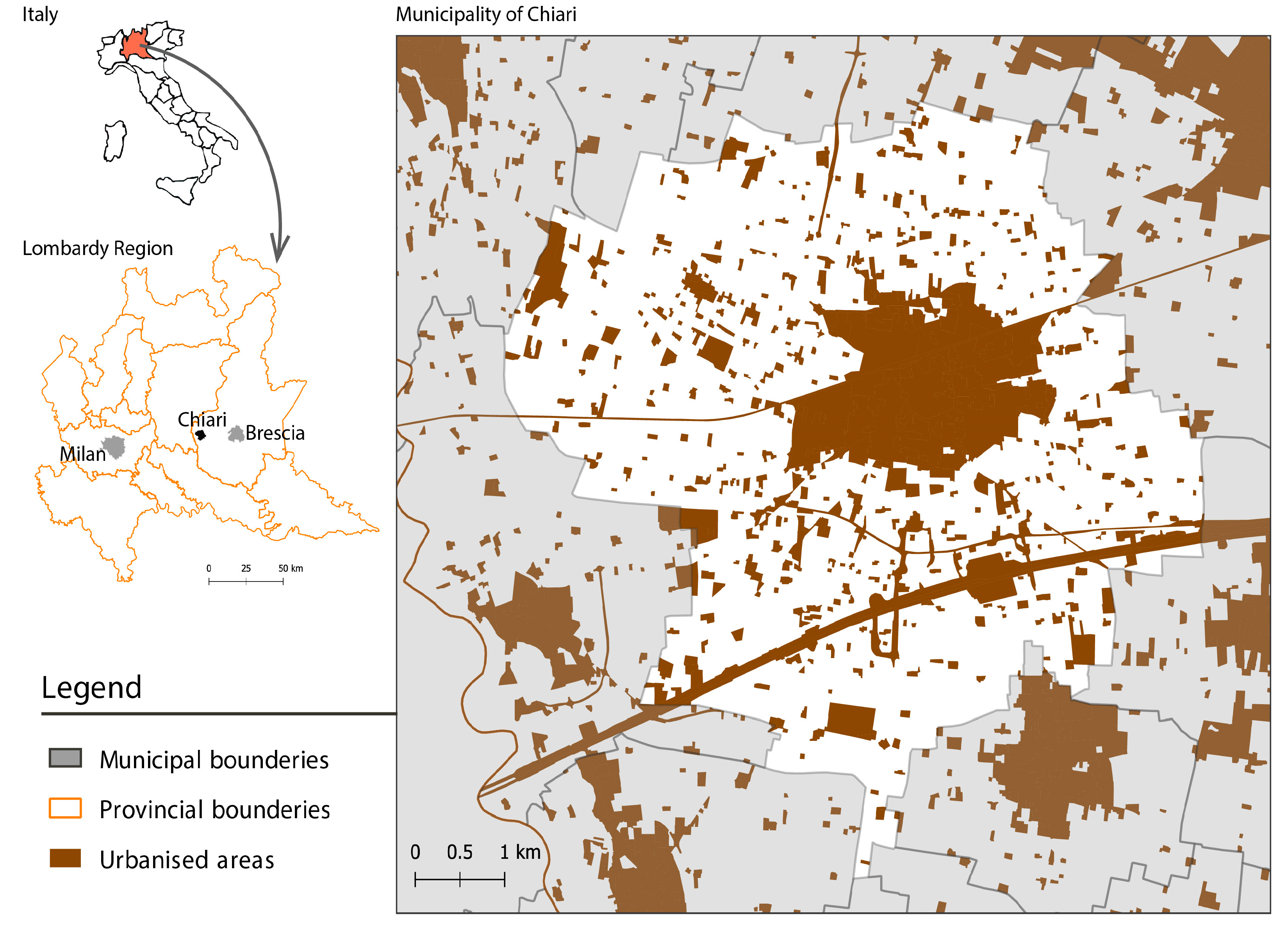
The municipality of Chiari is a town of almost 19,000 inhabitants, located in north-western Italy in the province of Brescia. In the Italian context, it is a medium-sized municipality and is the seventh municipality in the province of Brescia by population. It has an area of 38 sq km and a population density of 498 residents/sq km, which is almost double the provincial average. The municipal urban plan, approved in 2017, provides among its guidelines for the containment of land occupation and the recovery of abandoned and unused areas. The plan does not envisage significant population increases. Chiari has a very varied economy that ranges from the industrial sector to the agricultural and commercial sectors. Its companies are active in various production sectors: semi-finished brass products, textiles, food, woodworking etc. The agricultural activity consists of cereal products and derivatives from the dairy sector. The tertiary sector is highly developed and favored by the location of the city at the intersection of important road and railway junctions in the province of Brescia.
The morphology of the consolidated urban fabric (as defined by the regional law L.12/2005) of the municipality of Chiari tends to be compact (Figure 3).
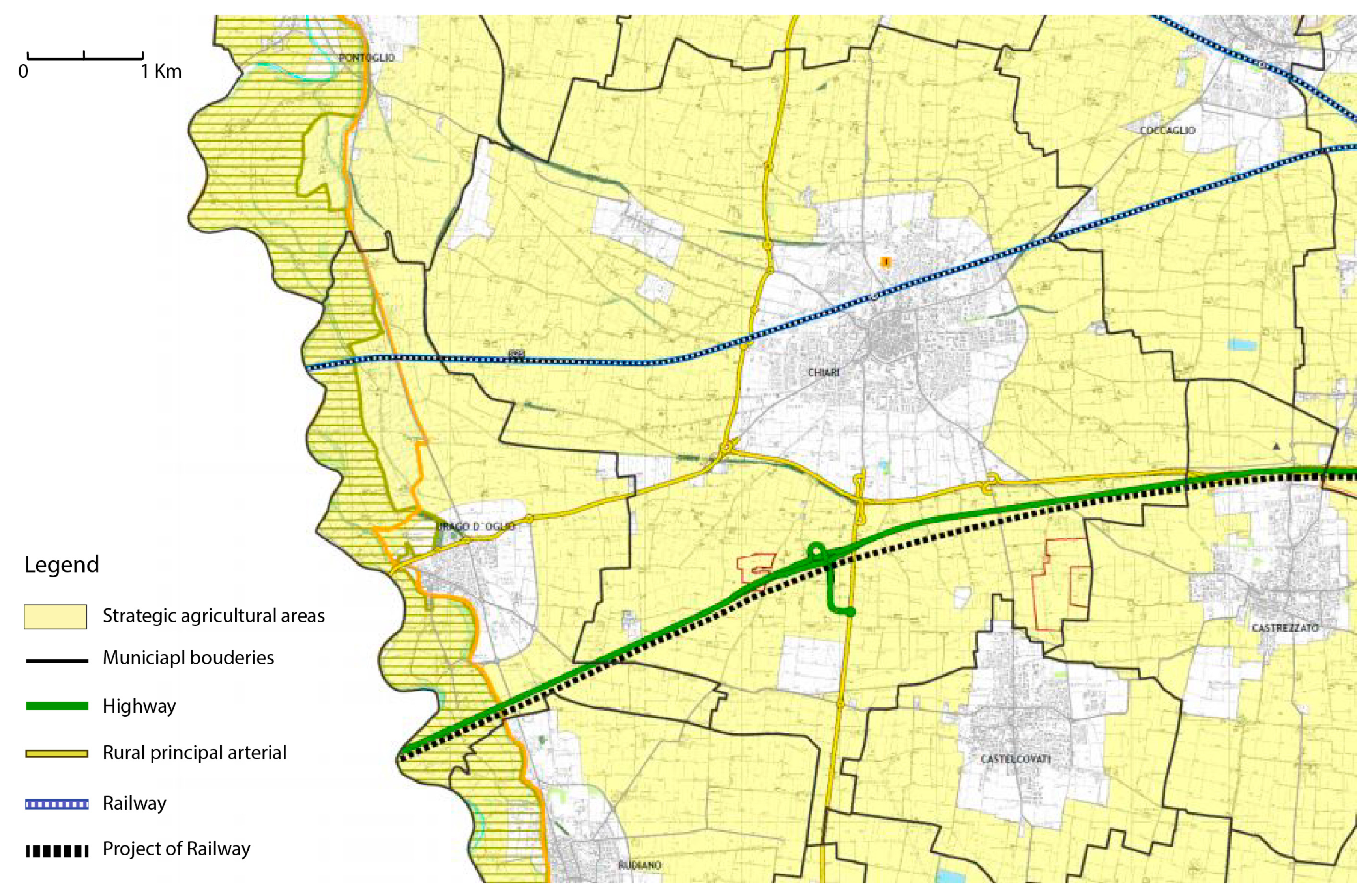
The municipality of Chiari also has agricultural areas of strategic interest (Provincial Coordination Plan of Brescia Province, art. 47–77, approved in 2014) for an area of about 29 sq km, as shown in the yellow background in Figure 4.
The agricultural area of Chiari does not present elements of natural development, but has been completely transformed by anthropic action, starting with the introduction of important irrigation works and high agricultural sectoring.
Historical literature shows that in 1934, when the municipality had about 13,500 inhabitants, almost half lived in the rural area (6000 inhabitants) and the buildings destined for this population numbered between 426 and 550 (the data are taken from two different sources: the site http://italia.indettaglio.it, which lists all the rural residential buildings existing before 1945, and the monograph of the Municipality of Chiari cited by the historian Mino Facchetti. The document is not signed or dated, according to Facchinetti it is a draft drawn up by the Municipality of Chiari towards the end of 1935). In 2016 15.3% of the population resided in the rural areas of Chiari (2875 inhabitants resided in hamlets, localities and scattered houses) while there were rural 637 buildings of which 563 were for residential use.
The accelerated evolution of the agricultural and livestock sector, the new needs of the population, the increase in residents not involved in agricultural activity and new infrastructures (for example a new highway) and activities (for example photovoltaic fields on the ground and biogas plants) are just some of the factors that are significantly changing the agricultural areas.
The case study is emblematic for the morphological characteristics of the municipality, the situation of the agricultural areas, the indications highlighted by the urban plan and the will of the municipal administrators to investigate the situation and problems of the agricultural areas through a specific part of the urban plan dedicated to agricultural areas.
3.2. Results
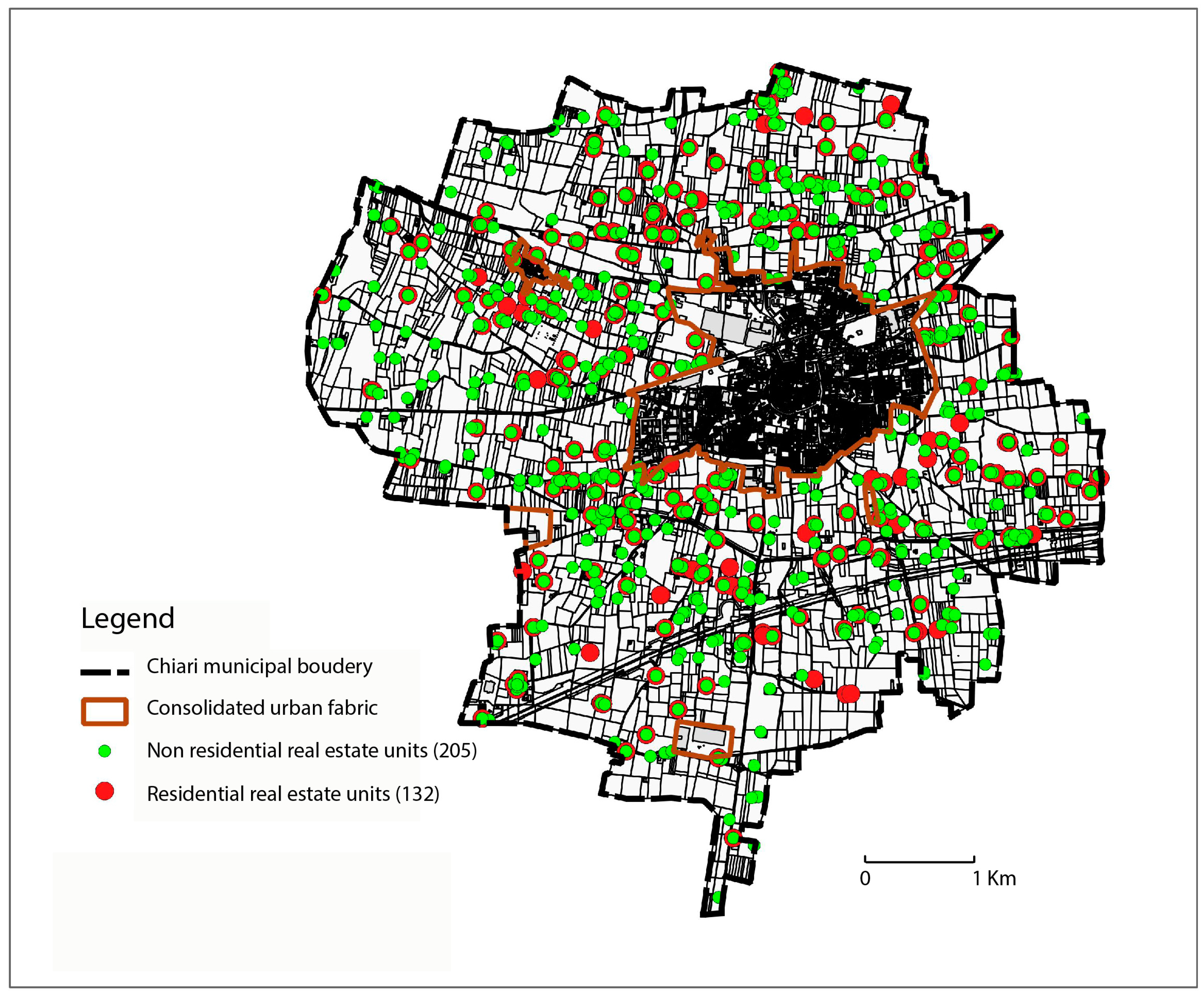
The methodology proposed in this paper made it possible to identify 337 unused units in agricultural areas in the municipality of Chiari, of which were 132 for residential use and 205 were for non-residential use, starting from an initial database of 1749 residential units and 19,543 real estate units.
The method utilized the QGIS geo-referenced data processing program to analyze the data.
Figure 5 shows the mapping of the unused residential (red) and non-residential (green) real estate units.
The municipality lends itself to a subdivision close to that of the four “square” ones that characterize it from the historical point of view. The southeast quadrant has 31% of the unused real estate units (equal to 102), the northwest quadrant 26%, the northeast quadrant 23% and the southwest quadrant 20% (Table 2).
The on-site checks were concentrated on the southeast quadrant, that is, the one with the highest number of unused real estate units.
Through phases 3 and 4 of the method concerning the transition from unused real estate units to unused buildings, 80 buildings partially or entirely unused were identified in the southeast quadrant.
In particular, by comparing the data on the degree of use of the buildings and their state of conservation, the first result of 32 completely unused buildings was achieved. By eliminating recurring errors of the analysis and non-catalogable buildings (not possible to find the degree of use of the real estate units), a 44 completely unused buildings in the rural area were definitively identified.
The recurring errors were classified as:
- “Ghost buildings” or buildings present in the municipal land register database, which in reality are ruins or non-existent;
- “Buildings catalogued by mistake”, or ruins subject to the waste tax.
The 44 entirely unused buildings have approximately 12,000 square meters of available surface.
The analysis of the recovery potential of unused buildings showed that:
- A total of 21 buildings have null recovery potential;
- Five buildings have low recovery potential;
- A total of 18 buildings have medium or high recovery potential.
An analysis of the municipal urban plan also allowed identifying the land use for the 337 unused real estate units. In particular, Table 3 shows the prevalence of units in the productive agricultural areas, in the agricultural areas with landscape-environmental and ecological values and in the agricultural areas for the control of urban development.
4. Discussion and Conclusions
The major limitation of the proposed method is certainly the availability of data used to build the initial database and the possibility of integrating data from different sources due to a unique identification code for each real estate unit. Additionally, once the selection of unused buildings has been made, the possibility remains that some of them were not catalogued, as it is not possible to ascertain the degree of use of the real estate units. In other cases, even such cases appear in insignificant numbers, it is not possible to associate the real estate units to the relative building because the identification code of the units may refer to buildings demolished in recent times compared to the analysis data or present errors that do not allow the traceability of the relevant building. The material errors in the formation of the database or the progressive evolution of the environment, if present, are within acceptable limits for the research methodology.
The last problem encountered is related to the on-site check, which does not always permit the definition of the degree of use of the building because the real estate units are not always visible or accessible from the road.
The only method comparable to the one proposed starts from an official open-source database that reports whether abusiness in a building or in real estate unit is working and refers only to specific land use (commercial) [1]. It is therefore not possible to make comparisons with other methods of investigation because they do not have the same purpose or the same subject.
Despite these limitations, the case study demonstrates the possibility, even for medium-small municipalities, to know their territory immediately and to evaluate the degree of use of rural areas. This degree of use is fundamental knowledge needed to establish policies and actions aimed at active land containment. From an operational point of view, without this valuable information, it is not possible to identify policies to better manage rural areas and it would not be possible to identify targeted actions for restructuring, or provide incentives for the demolition of buildings in rural areas. Additionally, the proposed method has the advantage of being applicable through open-source software, thanks to which the on-site analysis, which is longer and more expensive than the processing work, is reduced to a minimum.
It is important to highlight the possibility to integrate the methodology proposed with additional data in the GIS environment, for example, remote sensing data. This integration could be useful to implement other spatial multi-criteria analyses.
It would be desirable to extend the research to municipalities with different morphological characteristics and territorial vocations to determine comparisons and significant trends regarding the degree of use (and building abandonment) in rural areas. Even an extension of the method to the super-municipal scale would provide useful information to more municipalities that could thus coordinate their strategies and actions.
Funding
This work was supported by the Fondazione Cogeme Onlus.
Acknowledgments
I thank Claudio Maggioni and Andrea Spezia for the activities carried out and Alastair Tweedie for the English review.
Conflicts of Interest
The author declares no conflict of interest.
References
- Garda, E.; Gambazza, G. Il progetto del microabbandono nella città molecolare. Territorio 2016, 79, 99–108. [Google Scholar] [CrossRef]
- Brueckner, J.K. Urban Sprawl: Diagnosis and Remedies. Int. Reg. Sci. Rev. 2000, 23, 160–171. [Google Scholar] [CrossRef]
- European Environmental Agency. Urban sprawl in Europe—The Ignored Challenge; EEA: Copenhagen, Denmark, 2006. [Google Scholar]
- VV.AA. Urban Sprawl in Western Europe and the United States; Richardson, H.W., Bae, C.H.C., Eds.; Ashgate Publishing: Aldershot, UK, 2004. [Google Scholar]
- Hamidi, S.; Ewing, R. A longitudinal study of changes in urban sprawl between 2000 and 2010 in the United States. Landsc. Urban Plan. 2014, 128, 72–82. [Google Scholar] [CrossRef]
- EEA-FOEN. Urban Sprawl in Europe; EEA-FOEN: Luxembourg, 2016; p. 140. [Google Scholar]
- Salvati, L.; Gargiulo Morelli, V. Unveiling Urban Sprawl in the Mediterranean Region: Towards a Latent Urban Transformation?—Salvati—2014—International Journal of Urban and Regional Research—Wiley Online Library. Int. J. Urban Reg. Res. 2014. [Google Scholar] [CrossRef]
- Richiedei, A.; Tira, M. Municipal Budget Management and the Generation of Urban Sprawl. A Case Study of the Lombardy Region (Italy). Plan. Pract. Res. 2020, 35, 169–184. [Google Scholar] [CrossRef]
- Pezzagno, M.; Federici, M.; Pavesi, F.C. Il consumo di suolo tra stato di fatto e stato di diritto in Regione Lombardia. In Consumo di Suolo, Dinamiche Territoriali e Servizi Ecosistemici; Michele, M., Ed.; ISPRA: Roma, Italy, 2018; pp. 177–183. [Google Scholar]
- Rogerson, C.M. Tourism-agriculture linkages in rural South Africa: Evidence from the accommodation sector. J. Sustain. Tour. 2012, 20, 477–495. [Google Scholar] [CrossRef]
- Randelli, F.; Romei, P.; Tortora, M. An evolutionary approach to the study of rural tourism: The case of Tuscany. Land Use Policy 2014, 38, 276–281. [Google Scholar] [CrossRef]
- De Montis, A.; Ledda, A.; Ganciu, A.; Serra, V.; De Montis, S. Recovery of rural centres and “albergo diffuso”: A case study in Sardinia, Italy. Land Use Policy 2015, 47, 12–28. [Google Scholar] [CrossRef] [Green Version]
- Chen, D.; Liu, S.; Zhang, M.Y.; Li, S.L.; Wang, J. Comparison of the occurrence of antibiotic residues in two rural ponds: Implication for ecopharmacovigilance. Environ. Monit. Assess. 2018, 190, 539. [Google Scholar] [CrossRef]
- Zhang, X.L.; Han, L. Which Factors Factors Affect Farmers’ Willingness for rural community remediation? A tale of three rural villages in China. Land Use Policy 2018, 74, 195–203. [Google Scholar] [CrossRef]
- Aubry, C.; Paillat, J.M.; Guerrin, F. A conceptual representation of animal waste management at the farm scale: The case of the Reunion Island. Agric. Syst. 2006, 88, 294–315. [Google Scholar] [CrossRef]
- Zhang, J.; Chang, G.H. Discussion on the Feasibility of Idle Schoolhouse Reconstruction for Elderly Care Facilities in Rural Areas. In Proceedings of the International Conference on Culture, Education and Financial Development of Modern Society (Iccese 2017), Moscow, Russia, 12–13 March 2017; Volume 103, pp. 672–676. [Google Scholar]
- Della Croce, R. The system of abandoned and unused churches of Roero The strategic plan for their promotion through a series of cultural, tourist, environmental and gastronomic routes. Bo-Ric. Progett. Per Territ. Citta Archit. 2017, 8, 399–407. [Google Scholar]
- Akansu, V.; Gertik, A. The sustainability of unused industrial areas: An example, historical development of the Cyprus copper deposit. Amazon. Investig. 2018, 7, 91–103. [Google Scholar]
- Cibik, M.; Toth, A.; Stepankova, R. Integration of the historical watermill into a sustainable peri-urban riverfront redesign. In Proceedings of the Public Recreation and Landscape Protection—With Sense Hand in Hand, Křtiny, Czech Republic, 13–15 May 2019; Fialova, J., Ed.; Mendel University in Brno: Brno, Czech Republic, 2019; pp. 212–216. [Google Scholar]
- Agoramoorthy, G. The future of India’s obsolete dams: Time to review their safety and structural integrity. Futures 2015, 67, 22–25. [Google Scholar] [CrossRef]
- Hong, W.Y.; Li, F.X.; Li, M.C.; Zhang, F.F.; Tong, L.H.; Huang, Q.H. Toward a Sustainable Utilization of Land Resources in China: Problems, Policies, and Practices. Ambio 2014, 43, 825–835. [Google Scholar] [CrossRef] [Green Version]
- Liu, J.Y.; Deng, X.Z.; Liu, M.L.; Zhang, S.W. Study on the spatial patterns of land-use change and analyses of driving forces in northeastern china during 1990–2000. Chin. Geogr. Sci. 2002, 12, 299–308. [Google Scholar] [CrossRef]
- Song, W.; Chen, B.M.; Zhang, Y.; Wu, J.Z. Establishment of Rural Housing Land Standard in China. Chin. Geogr. Sci. 2012, 22, 483–495. [Google Scholar] [CrossRef]
- Droli, M. Rating Rural Hamlets for their Business Start-Up Potentials: Reality or Utopia? In Proceedings of the Society, Integration, Education, Utopias and Dystopias in Landscape and Cultural Mosaic, Visions Values Vulnerability, Udine, Italy, 27–28 June 2013; Rezekne Higher Educ Inst-Rezeknes Augstskola: Riga, Latvia; pp. 21–33. [Google Scholar]
- Fang, Y.G.; Liu, J.S. The modification of North China quadrangles in response to rural social and economic changes in agricultural villages: 1970–2010s. Land Use Policy 2014, 39, 266–280. [Google Scholar] [CrossRef]
- Maniaci, A.; Salemi Scarcella, G.; Piscitelli, M. Development of the Urban-Rural Network in the Metropolitan Area of the Strait of Messina Through the Recovery of the Historical and Cultural Obsolete Heritage; Iris: Aurora, CO, USA, 2015; Volume 56, pp. 842–850. [Google Scholar]
- Aureli, D. The third way, rurban way of life. In Proceedings of the 3rd International Multidisciplinary Scientific Conference on Social Sciences and Arts, SGEM, Vienna, Austria, 6–9 April 2016; pp. 805–810. [Google Scholar]
- Saddek, G.; Alrikabi, N.K.; Ahmed, Z.A. Siting of Proposed Areas for Urban Agriculture in the City of Baghdad; Postmodern Urban and Regional Planning in Iraq; KnE Engineering: Dubai, UAE, 2018; pp. 68–82. [Google Scholar]
- Branduini, P. Il patrimonio rurale nutre la città. Econ. E Soc. Reg. 2016. [Google Scholar] [CrossRef]
- Arzeni, A. Agricoltura & green economy: Il ruolo e il contributo diretto e indiretto dell’agricoltura allo sviluppo sostenibile. Prism. Econ. Soc. E Lav. 2011, 2, 95–109. [Google Scholar] [CrossRef]
- Bergamaschi, M. Nuove Frontiere Dello Spazio Pubblico Urbano Orti e Giardini Condivisi; Franco Angeli: Milano, Italy, 2012; Volume 34, pp. 1–160. [Google Scholar]
- Guarascio, C. Reti alternative agroalimentari ed economia solidale. Sociol. Urbana E Rural. 2015, 107, 88–105. [Google Scholar] [CrossRef]
- Colavitti, A.M.; Serra, S. Controllare l’impossibile: Urbanistica e consumo di suolo nella sfida per la città futura. Sci. Reg. Ital. J. Reg. Sci. 2016, 15, 101–122. [Google Scholar] [CrossRef]
- Dal Co, M. Tax increment financing: Uno strumento di partenariato per il recupero delle aree urbane. Arch. Studi Urbani E Reg. 2018, 122, 177–191. [Google Scholar] [CrossRef]
- Lino, B.; Orlando, M.; Carta, M. Innovazione sociale e creatività: Nuovi scenari di sviluppo per il territorio sicano. Anal. Sist. Urbani E Reg. 2018, 123, 140–162. [Google Scholar] [CrossRef]
- Camerin, F.; Gastaldi, F. Verso un censimento delle aree militari in Veneto. Arch. Studi Urbani E Reg. 2018, 123, 51–75. [Google Scholar] [CrossRef]
- Ponzini, D.; Vani, M. Immobili militari e trasformazioni urbane. Territorio 2012, 62, 13–18. [Google Scholar] [CrossRef]
- Patruno, A. Valorizzazione degli immobili statali militari: L’importanza di un metodo. Territorio 2012, 62, 19–21. [Google Scholar] [CrossRef]
- Geusa, M. Aree militari dismesse e trasformazioni urbane: L’esperienza di Roma. Territorio 2012, 63, 29–33. [Google Scholar] [CrossRef]
- Hercik, J.; Toušek, V.; Šery, O. La conversione dei siti militari nella Repubblica Ceca: I casi di Hodonín e Uherské Hradiste. Territorio 2012, 62, 43–48. [Google Scholar] [CrossRef]
- Camerin, F.; Gastaldi, F. Verso una nuova fase del processo di valorizzazione del patrimonio militare italiano? Territorio 2017, 80, 151–156. [Google Scholar] [CrossRef]
- Voghera, A. Un patrimonio minore: Capitale fisso sociale e ricostruzione di contesti territoriali. Arch. Studi Urbani E Reg. 2017, 119, 35–50. [Google Scholar] [CrossRef]
- Micelli, E. Enabling real property: How public real estate assets can serve urban regeneration. Territorio 2018, 87, 93–97. [Google Scholar] [CrossRef]
- Orsenigo, G.; Marchigiani, E.; Maranghi, E. Recuperare il patrimonio abitativo pubblico con gli inquilini. Territorio 2019, 88, 25–28. [Google Scholar] [CrossRef]
- Storto, G. Il destino incerto dell’edilizia residenziale pubblica. Territorio 2019, 88, 29–35. [Google Scholar] [CrossRef]
- Cognetti, F.; Padovani, L. Ri-attribuire valore e senso ai quartieri di edilizia residenziale pubblica e alla politica della casa: Percorsi attraverso il quartiere San Siro a Milano. Arch. Studi Urbani E Reg. 2016, 117, 5–25. [Google Scholar] [CrossRef]
- Bonfantini, B. Tra abbandono ed estrazione: Sul futuro di centri e territori storici. Territorio 2018, 87, 189–192. [Google Scholar] [CrossRef]
- Celestini, C.D. La riqualificazione dell’area ex Seabo. In Archivio di Studi Urbani e Regionali; Franco Angeli: Milano, Italy, 2003; pp. 1–6. [Google Scholar]
- Cozza, C. Da spazi abbandonati a patrimoine vivant: Rigenerazione di architetture industriali. Territorio 2019, 89, 35–43. [Google Scholar] [CrossRef]
- Orsenigo, G. Tipologie industriali e declinazioni del riuso: Il caso dei cementifici. Territorio 2019, 69–75. [Google Scholar] [CrossRef]
- Bruzzese, A. Accompagnare la conversione delle centrali termoelettriche: Il progetto Futur-e e i suoi strumenti operativi. Territorio 2018, 86, 85–91. [Google Scholar] [CrossRef]
- Palazzotto, E. La Centrale Tifeo ad Augusta: Natura dialettica e progetti per un recupero possibile. Territorio 2019, 89, 54–61. [Google Scholar] [CrossRef]
- VV.AA. Territorio; Franco Angeli: Milano, Italy, 2008; Volume 45, pp. 1–151. [Google Scholar]
- Pavia, R. Compost city. CRIOS 2016, 11, 9–20. [Google Scholar] [CrossRef]
- Pellegrini, M. Un percorso tra quartieri pubblici e campagne urbane: Relazioni di prossimità nelle frange periurbane di Trieste sud-est. Territorio 2016, 79, 70–73. [Google Scholar] [CrossRef]
- Giannini, A. Tra ruralizzazione ed urbanizzazione: Progetti integrati città-campagna. Territorio 2009, 49, 171–177. [Google Scholar] [CrossRef]
- De Santoli, L. Riqualificazione energetica e bioedilizia in Italia: Lo stato dell’arte. In Prisma, Economia, Società, Lavoro; Franco Angeli: Milano, Italy, 2011; Volume 2, pp. 74–88. [Google Scholar]
- García Quesada, R.; Minutoli, F. La riqualificazione energetica dell’housing sociale attraverso interventi economico-sostenibili. Arch. Studi Urbani E Reg. 2017, 172–179. [Google Scholar] [CrossRef]
- Wilson, M.I. Mega-Events and Legacies: Milan Expo 2015 and the Future Event City. Territorio 2016, 77, 106–109. [Google Scholar] [CrossRef]
- Gaeta, L.; Curci, F. I giochi olimpici di Londra e la rigenerazione dell’East End. Territorio 2016, 77, 110–119. [Google Scholar] [CrossRef]
- Franz, G. La cittá: Riqualificare, trasformare, rinnovare. Strumenti e recenti politiche di riqualificazione urbana. Arch. Studi Urbani E Reg. 2001, 70, 1–14. [Google Scholar] [CrossRef]
- Laino, G. Condizioni per l’efficacia dei programmi di riqualificazione nell’ottica dello sviluppo locale. Arch. Studi Urbani E Reg. 2001, 70, 139–168. [Google Scholar] [CrossRef]
- Ave, G. Il recupero urbano come politica integrata per lo sviluppo delle cittá in un sistema territoriale policentrico tra centri urbani densi. Arch. Studi Urbani E Reg. 2001, 70, 167–188. [Google Scholar] [CrossRef]
- Bocco, A.; Tranquillo, N.; Caliri, G.; Lazzarino, E. Community hub e rigenerazione urbana: Qualche nota interdisciplinare. Territorio 2018, 84, 79–86. [Google Scholar] [CrossRef]
- Calvaresi, C.; Lazzarino, E. Community hub: Un nuovo corso per la rigenerazione urbana? Territorio 2018, 84, 77–78. [Google Scholar] [CrossRef]
- Treu, M.C. La questione delle aree agricole e gli strumenti di piano territoriale e urbanistico. Territorio 2009, 49, 47–56. [Google Scholar] [CrossRef]
- Galdini, R. L’uso del temporaneo nei processi di rigenerazione urbana. Sociol. Urbana E Rural. 2015, 107, 20–34. [Google Scholar] [CrossRef]
- Richiedei, A.; Mazzetti, F. Il paesaggio come bene comune: La mappatura e la valorizzazione del patrimonio rurale come strumenti per la sua trasmissibilità. In Proceedings of the Atti della XXII Conferenza Nazionale SIU, L’Urbanistica Italiana di Fronte all’Agenda 2030, Portare Territori e Comunità Sulla Strada Della Sostenibilità e Resilienza, Matera/Bari, Italy, 5–7 June 2019; Planum publisher: Milano/Roma, Italy, 2020; pp. 1530–1535. [Google Scholar]
Figure 1.
Methodology flowchart.

Figure 2.
Details of the state of conservation criteria.

Figure 3.
Overview of Municipality of Chiari with identification of urbanized and rural areas.

Figure 4.
Strategic agricultural areas (in yellow) of the municipality of Chiari (Extract from Table 5.2, Areas for the agricultural activity of strategic interest in the Provincial Coordination Plan of the Province of Brescia approved in 2014).
Figure 4.
Strategic agricultural areas (in yellow) of the municipality of Chiari (Extract from Table 5.2, Areas for the agricultural activity of strategic interest in the Provincial Coordination Plan of the Province of Brescia approved in 2014).

Figure 5.
Unused residential real estate units (red) and non-residential real estate units (green) in the municipality of Chiari (2017) (elaboration from Richiedei and Mazzetti [68]).
Figure 5.
Unused residential real estate units (red) and non-residential real estate units (green) in the municipality of Chiari (2017) (elaboration from Richiedei and Mazzetti [68]).


Table 1.
Score and criterion of the degree of recovery potential for rural buildings.
| Recovery Potential | Score | Description |
|---|---|---|
| High | >3 | Buildings are more predisposed toward a possible recovery. These buildings are enhanced by at least two of the following aspects: building conditions, relationship with road infrastructure and urban core, and proximity to landscape points of interest. They are not close to elements of degradation. |
| Medium | 1 or 2 | Buildings are qualified to be recovered. These are buildings enhanced by at least one of the following aspects: building conditions, relationship with road infrastructures and urban core, and proximity to landscape points of interest. They are rarely near elements of degradation. |
| Low | 0 | Buildings are less predisposed toward a possible recovery. In these buildings, the negative factors counterbalance positive ones, resulting an overall zero value of the building improvement. They are mostly located near elements of degradation. |
| Null | <0 | Buildings are not predisposed toward a possible recovery. In these buildings, the negative factors outweigh the positive ones, determining an overall negative value for building renovation. They are mainly located near elements of degradation. |
Table 2.
Unused real estate units in agricultural areas in the municipality of Chiari divided to quadrants.
Table 2.
Unused real estate units in agricultural areas in the municipality of Chiari divided to quadrants.
| Unused Real Estate Units | |||
|---|---|---|---|
| Quadrant | Residential | Non Residential | Total |
| Northwest | 34 | 52 | 86 |
| Northeast | 20 | 59 | 79 |
| Southwest | 34 | 35 | 69 |
| Southeast | 44 | 58 | 102 |
| Total | 132 | 205 | 337 |
Table 3.
Division of unused real estate units according to land use. For each agricultural land use the reference rule (article) of the municipal urban plan that describes it is reported.
Table 3.
Division of unused real estate units according to land use. For each agricultural land use the reference rule (article) of the municipal urban plan that describes it is reported.
| Real Estate Units | Productive Agricultural Areas (Art. 35) | Agricultural Areas with Landscape-Environmental and Ecological Value (Art. 36) | Agricultural Areas for the Control of Urban Development (Art. 36 bis) | Areas for Flower Nursery Activities (Art. 36 ter) | Areas with Mining Activities Subject to Environmental Recovery Projects (Art. 34 Quinques) |
|---|---|---|---|---|---|
| Residential | 108 | 10 | 14 | 0 | 0 |
| Non Residential | 145 | 9 | 38 | 1 | 12 |
| Total | 253 | 19 | 52 | 1 | 12 |
© 2020 by the author. Licensee MDPI, Basel, Switzerland. This article is an open access article distributed under the terms and conditions of the Creative Commons Attribution (CC BY) license (http://creativecommons.org/licenses/by/4.0/).
Share and Cite
MDPI and ACS Style
Richiedei, A. The Valuation of Idle Real Estate in Rural Areas: Analysis and Territorial Strategies. Sustainability 2020, 12, 8240. https://0-doi-org.brum.beds.ac.uk/10.3390/su12198240
AMA Style
Richiedei A. The Valuation of Idle Real Estate in Rural Areas: Analysis and Territorial Strategies. Sustainability. 2020; 12(19):8240. https://0-doi-org.brum.beds.ac.uk/10.3390/su12198240
Chicago/Turabian StyleRichiedei, Anna. 2020. "The Valuation of Idle Real Estate in Rural Areas: Analysis and Territorial Strategies" Sustainability 12, no. 19: 8240. https://0-doi-org.brum.beds.ac.uk/10.3390/su12198240
Note that from the first issue of 2016, this journal uses article numbers instead of page numbers. See further details here.