Article

Empirical Research on Climate Warming Risks for Forest Fires: A Case Study of Grade I Forest Fire Danger Zone, Sichuan Province, China

1
College of Architecture and Urban Planning, Qingdao University of Technology, Qingdao 266033, China
2
College of Forestry, Beijing Forestry University, Beijing 100083, China
*
Author to whom correspondence should be addressed.
Sustainability 2021, 13(14), 7773; https://0-doi-org.brum.beds.ac.uk/10.3390/su13147773
Submission received: 31 March 2021 / Revised: 3 July 2021 / Accepted: 6 July 2021 / Published: 12 July 2021
(This article belongs to the Section Air, Climate Change and Sustainability)

Abstract

:
The Sichuan province is a key area for forest and grassland fire prevention in China. Forest resources contribute significantly not only to the biological gene pool in the mid latitudes but also in reducing the concentration of greenhouse gases and slowing down global warming. To study and forecast forest fire change trends in a grade I forest fire danger zone in the Sichuan province under climate change, the dynamic impacts of meteorological factors on forest fires in different climatic regions were explored and a model between them was established by using an integral regression in this study. The results showed that the dominant factor behind the area burned was wind speed in three climatic regions, particularly in Ganzi and A’ba with plateau climates. In Ganzi and A’ba, precipitation was mainly responsible for controlling the number of forest fires while it was mainly affected by temperature in Panzhihua and Liangshan with semi-humid subtropical mountain climates. Moreover, the synergistic effect of temperature, precipitation and wind speed was responsible in basin mid-subtropical humid climates with Chengdu as the center and the influence of temperature was slightly higher. The differential forest fire response to meteorological factors was observed in different climatic regions but there was some regularity. The influence of monthly precipitation in the autumn on the area burned in each climatic region was more significant than in other seasons, which verified the hypothesis of a precipitation lag effect. Climate warming and the combined impact of warming effects may lead to more frequent and severe fires.

1. Introduction

Fire is one of the most important disturbances on the earth affecting most terrestrial ecosystems [1] and it plays a key role in determining the landscape structure and plant community composition [2]. The evidence suggests that since the last glaciation there have been substantial interactions between fire and the stand structure [3], the fuel characteristics [4,5,6], biological invasion [7], human activities [8,9], the terrain conditions [10,11], changes in land uses [9,12] and the climate [1,13,14,15,16]. Among these, the climate is considered to be a key factor attributed to medium and large scale forest fires [14,15,16]. Within the context of prospective climate change during the 21st century, the relationship between forest fires and climate change has become a focal research topic [12,15,16,17,18] and middle and subtropical latitudes will see an increased fire danger risk and an extension of the fire-hazardous period whereas the high altitudes will undergo more limited changes in the risk [9,19]. Mathematical modeling is an effective method for studying a forest fire response to climate change, particularly at large scales, and has provided many resources for forest fire ecology and it has accelerated the relevant research as well. For instance, Chen et al. (2015) analyzed the link between forest fire occurrence and the climatic variables in the Yunnan province by using a logistic equation and found that the precipitation regimes showed a significant relationship with the fire activities in different ecoregions [20]. Groisman et al. (2004) showed a significant (sometimes a two-fold) increase in the indices that characterized that weather conditions were conducive to forest fires using meteorological information for the past century [21]. Wotton et al. (2010) used two general circulation models (GCMs) to develop projections of future fire occurrence across Canada and projected fire climate scenarios derived from the Hadley Centre GCM, indicating that fire occurrence would increase by 140% by the end of this century in Canada [22]. Lasslop and Kloster (2013) analyzed the response functions including other important drivers of the area burned, e.g., temperature, net primary productivity, precipitation, tree cover and population density, using generalized additive models (GAMs) [23]. Varela et al. (2019) used the Fire Weather Index (FWI) to demonstrate that fire occurrence and behavior in Mediterranean-type ecosystems strongly depend on air temperature and wind conditions and that the amount of fuel load and drought conditions leads to a drastic increase in inflammability, particularly during the summer [24]. Climate warming and the combined influence of its effects may lead to more frequent and severe fires and the fire risk period may be extended in the western United States [25]. According to above-mentioned studies, precipitation, wind speed, relative humidity and temperature have proved to be the main meteorological factors affecting forest fires; however, most of the results identified correlations between single factors and forest fires based on the linear correlation over the entire research period. The impacts of climate change on wildfire are varying and are coupled with several other factors; however, there is only limited research on the synergistic effects of continuous variability with multi-temporal multi-factors. Forest fires are climate-driven and climate-relevant processes; thus, a realistic response of a modeled fire occurrence with respect to different climate variables is crucial [23].
The integral regression proposed by Fisher not only revealed the relationship between pre-measurements (a dependent variable) and influence factors (an independent variable) but also clarified which variables are the main influencing factors and which are secondary [26]. Simultaneously, the equation also took into account the temporal variability of the independent variables because their values in different periods (such as every month) affect the predicted quantity; thus, the influence in one period may be negative and the influence in another may be positive [27]. More importantly, the regression parameter of the integral regression analysis method is a function of time and its value can quantitatively reflect the contribution rate of the unit change of a certain factor to the dependent variable. The greater the contribution rate, the more sensitive the dependent variable to the change of a certain factor in a certain period [26]. The integral regression equation has been widely used in the study of climate change and forests, such as by Qiu and Jiang (1989) [28], Jiang et al. (1990) [29] and Wu et al. (2020) [30].
At present, the Sichuan province is a key area for forest and grassland fire prevention in China. Eighty-one counties (cities, districts) are listed as high-risk areas, accounting for 23% of China’s high-risk forest fire areas [31]. From 1979 to 2008, there was an average of 2674 fire incidents per year with an annual average area burned of 111.85 million ha and annual casualties involving the deaths of dozens of people, incurring an average economic loss of more than USD 10 million directly related to forest fires in the Sichuan province [32]. Larger forest fires occurred in Liangshan in 2019 and 2020. In particular, the area burned was about 90 ha in 2020 when the wind speed at the fire site was 10 m·s−1, the temperature was 13–30 °C, the relative humidity was 10–25% and there was no rainfall (http://www.sc.gov.cn/10462/wza2012/scgk/scgk.shtml, accessed on 15 March 2020). Since 2019, the Sichuan province has experienced many rounds of high forest and grassland fire risk tests, particularly to the west of Panzhihua and the western plateau of the Sichuan province where the fire risk is still high, thus the prevention and control are more challenging. Moreover, the forest area is 18.40 million ha and the forest volume is 186.1 million m3, which ranks fourth and third place in China, respectively, and is overall the nation’s third largest forest area (http://www.sc.gov.cn/10462/10464/10797/2018/4/18/10381665.shtml, 15 March 2020). Forest resources contribute significantly not only to the biological gene pool in the mid latitudes but also to reducing the concentration of greenhouse gases and slowing down global warming. Their rise and fall significantly impact the global environment and even human survival. In order to minimize the damage caused by forest fires, it is necessary to know how meteorological factors affect the occurrence and timing of forest fires. Continuous monitoring is required that can help repair forest ecosystems in the region and aid in providing a comprehensive understanding of the history of forest fires and their development. Recently, the research on forest fires in the Sichuan province has focused on the temporal and spatial distributions [32], forest fuel distribution, canopy fire mechanisms and relationship between regional climate change and fire [7], for example. The results have described the relationship between forest fires and meteorological factors on an annual scale and proved that meteorological conditions are significantly important factors in Sichuan province forests, which also impact on forest fires [32]. However, most wildfire studies have ignored the impacts of month-by-month meteorological influences during the fire prevention period in different climatic regions. Therefore, the study of the relationship between forest fires and monthly climate change in the Sichuan province provides a useful guideline in the context of global warming for forest fire prevention measures in low and middle latitude areas.
In this study, it was hypothesized that fire severity increases with global warming and a lag in the impact of precipitation on forest fires. The estimation was done in the following steps: first, the influence of temperature, wind speed and precipitation on the number and area burned by forest fires was analyzed by using an integral regression in the Sichuan province; second, a statistical model relating the number of fires and the area burned to meteorological factors in different regions was established. The research conclusion has a theoretical significance for the establishment of scientific and accurate prediction models of forest fire occurrence and development in the Sichuan province.

2. Materials and Methods
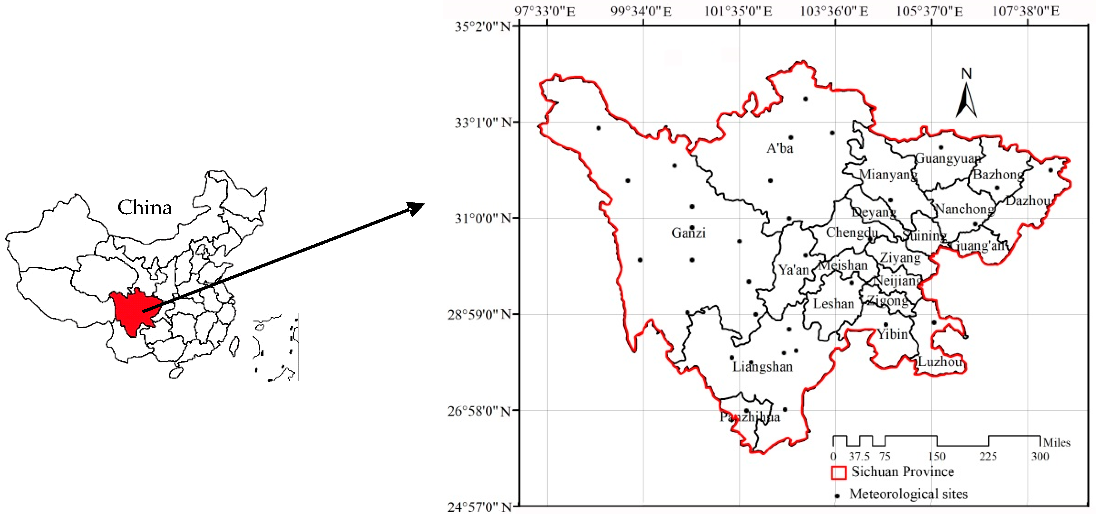
2.1. Study Area

The Sichuan province is located in southwestern China (between 97°21′–108°12′ E and 26°03′–34°19′ N) (Figure 1). With comparatively advantageous natural environments, a vast spatial territory, rich land resources, a complex and varying climate and thriving resources, it has good preconditions for studies related to the environment, forest fires and climate change. The study site is composed of 77.2% mountains, 12.9% hills, 5.3% plains and 4.7% plateaus and is divided into three parts: the Sichuan Basin, the Northwest Sichuan plateau and the southwest Sichuan mountainous area with a corresponding humid climate in the middle subtropics of the basin (including Chengdu, Ya’an, Leshan, Mianyang, Guangyuan, Nanchong, Bazhong, Dazhou, Yibin and Luzhou), a subtropical semi-humid climate in the mountainous areas of southwest Sichuan (including Liangshan and Panzhihua) and an alpine climate in northwest Sichuan (including A’ba and Ganzi). The annual average temperatures are between 16 and 18 °C, there are 1600 average sunshine hours and average annual precipitation is between 1000 and 1200 mm. There are more than 10,000 plant species associated with 145 wild animals for national priority protection, making up 33.33% and 39.60% of China’s totals, respectively. The forest coverage rate was 38.83% in 2018.
The study area was divided into four fire danger zones: grades I, II, III and others by the Sichuan Forestry and Grassland and Administration based on the Forest Fire Prevention Regulations and the Rank of the Regionalization on Nationwide Forest Fire Risk (LY/T1063-2008), combining the forestland area, the standing stock of the trees, precipitation, temperature and wind speed. The Grade I fire risk area (with a high risk) included A’ba, Ganzi, Chengdu, Ya’an, Leshan, Mianyang, Guangyuan, Nanchong, Bazhong, Dazhou, Yibin, Luzhou, Liangshan and Panzhihua (Figure 1).

2.2. Data Collection

Historical data on forest fires (the number of fire incidents and area burned) between 1984 and 2011 were correlated with the climatic parameters (temperature, wind speed and precipitation) acquired monthly from 33 weather stations across the studied area in the Sichuan province, China.

2.2.1. Fire Data

The fire data were provided by Forest Fire Prevention Office of the Sichuan province from 1984 to 2011 along with supporting attribute information (fire location, start date, cause, area burned, fire suppression costs and point coordinates). In this study, the fire season was defined as the period from November to May of the following year according to the Forest Fire Prevention method for the Sichuan province.

2.2.2. Meteorological Data

A ‘nowcast’ from China’s Meteorological Data Sharing Service System was used to obtain up-to-date meteorological data from 1984 to 2011 (http://data.sheshiyuanyi.com/WeatherData/, accessed on 5 March 2020). It included a total of 33 meteorological sites in the Sichuan province (Figure 1). The meteorological data included the daily average temperature, maximum temperature, minimum temperature, average wind speed and daily rainfall from 1984 to 2011.
The daily temperature data were preprocessed by using the Laiyite Criterion [33] and the daily average temperature was replaced with the average of the daily maximum temperature and the minimum temperature when the daily average temperature was abnormal but the daily maximum temperature and minimum temperature were normal. In case the daily maximum and minimum temperatures were also abnormal, the daily average temperature was replaced with a five-day moving average and the daily temperature data were corrected by the moving average method [34]. Combined with historical precipitation in the Sichuan province, daily precipitation at 600 mm was set as the threshold and it was directly removed as the abnormal value when higher than this value was observed [35]. Data were then available for 324 station months at 33 meteorological stations in different climatic regions including wind speed (WS) (m·s−1), temperature (°C) and precipitation (mm).

2.3. Data Analysis

Herein, an integral regression was used to evaluate the area burned and the number of forest fires. The integral regression model is represented as follows:
y = c + i = 1 k 0 a i ( t ) X i ( t ) d t .
If a forest fire (area burned and the number of fires) is y and meteorological factors (T, WS and P) are X1, X2 and X3, respectively, they are functions of time. If each year is divided into 12 periods by month, the integral regression formula is as follows:
y = c + 0 12 [ a 1 ( t ) X 1 ( t ) + a 2 ( t ) X 2 ( t ) + a 3 ( t ) X 3 ( t ) ] d t
where y is the forest fire (the number of fires and area burned) and a1(t), a2(t) and a3(t) are the influence coefficients or changes in the number or area burned when the temperature and wind speed increase by one unit at t + Δt. The influence coefficient units are hectare and time and are also known as the sensitivity index. X1(t), X2(t) and X3(t) are the measured values of T, WS and P, respectively, and c is a constant.
a1(t), a2(t) and a3(t) are time functions; thus, they are transformed by using the orthogonal polynomial regression as the following formulae:
a 1 ( t ) = j α 1 j Φ j ( t )
a 2 ( t ) = j α 2 j Φ j ( t )
a 3 ( t ) = j α 3 j Φ j ( t )
where Φj(t) is an orthogonal polynomial of time and j is time. The study considered five times [36]. The α1j, α2j and α3j are the following Equation (4).
Where temperature is T, wind speed is WS and precipitation is P, then:
T i ( t ) = 0 12 Φ j ( t ) T 1 ( t ) d t
W S i ( t ) = 0 12 Φ j ( t ) W S 1 ( t ) d t
P i ( t ) = 0 12 Φ j ( t ) P 1 ( t ) d t .
If Equation (3) is substituted into Equation (2), then Equation (2) is written as a regression equation, as follows:
y = c + α 10 T 0 + α 11 T 1 + + α 15 T 5 + α 20 P 0 + + α 25 P 5 + α 30 W S 0 + + α 35 W S 5
where y is the predicted value of the area burned or number of fires. First, the independent variables X1(t), X2(t) and X3(t) (t = 1, 2…12) are converted to Tj, WSj and Pj (T is temperature, WS is wind speed and P is precipitation; j = 0, 1…5), respectively. Second, Equation 5 is solved by the least square method and α1j, α2j, α3j and c are calculated simultaneously. Third, by substituting it into Equation (3), the influence coefficient a1(t), a2(t) and a3(t) can be obtained. a(t) represents the area burned (number of fires) of forest fires that increases or decreases by adding a meteorological unit to the temperature, wind speed and precipitation. Finally, considering a1(t), a2(t) and a3(t) and measuring the average values of temperature (°C), wind speed (m·s−1) and precipitation (mm) during the period of forest fires into Equation (2), both the number of fires and the area burned can be predicted by using an equation in the format of Equation (2) and finally Equation (5).
The statistical analyses were performed by using R software (2.15.2) and differences were considered significant at the level of 0.05.

3. Results

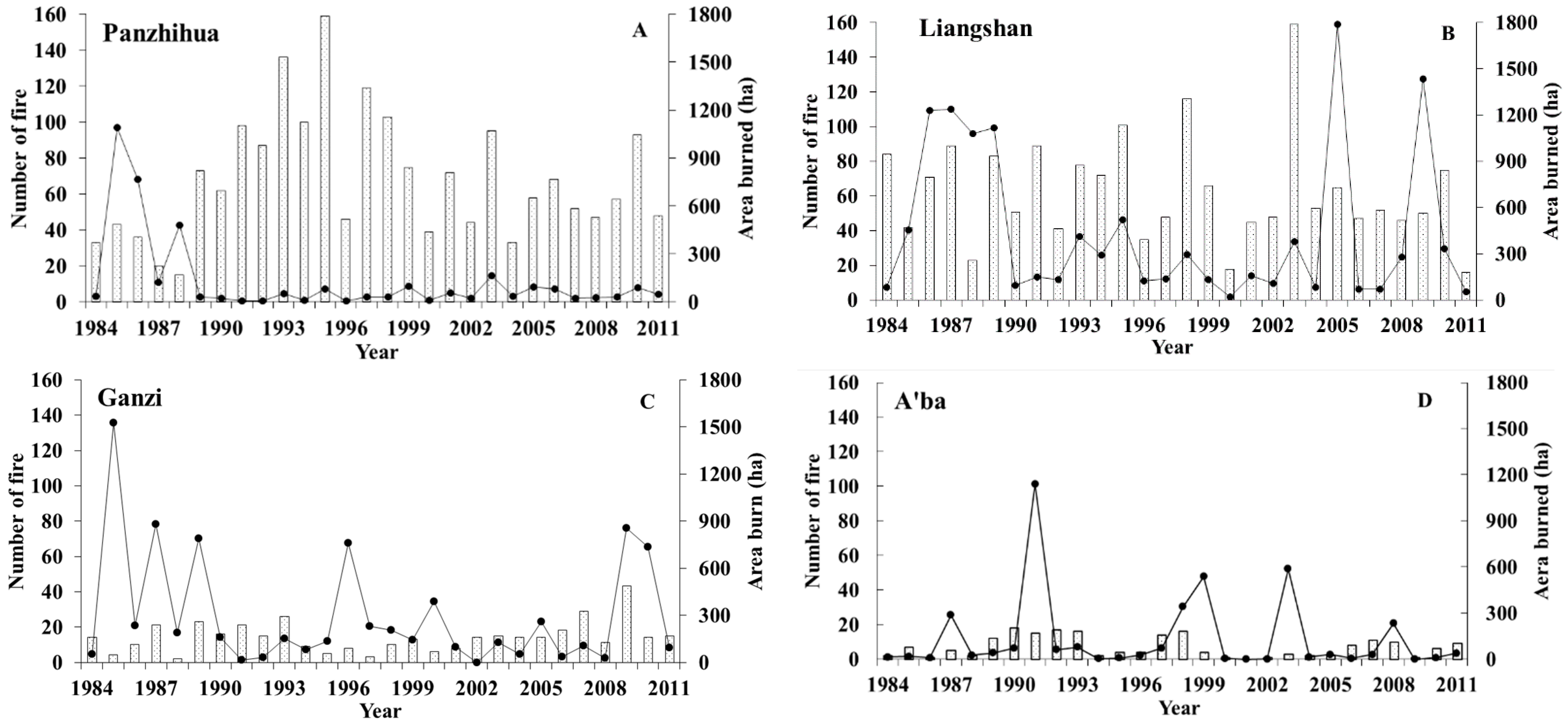
3.1. Variations in the Number of Fires and the Area Burned in Different Climatic Regions

In summary, from 1984 to 2011, a total of 7103 forest fires occurred between January to December in the Sichuan province with an area burned of 103,389.27 ha.
Figure 2 shows that the number of fires and the area burned in Panzhihua and Liangshan—which have the semi-humid, subtropical mountain climate of southwest Sichuan—were higher than those in the other two climatic zones (Figure 2A,B). There were on average 68 and 62 fire incidents per year with an annual average area burned of 125.85 and 437.81 ha and average individual fire areas of 1.99 and 6.94 ha, respectively. There was only one particularly serious forest fire (1091 ha) in Panzhihua in 1985 but there were six fires in Liangshan that burned 1230.20, 1239.06, 1078.00, 1118.00, 1787.00 and 1434.94 ha, respectively. It is the largest region in the study area and forest fire prevention deserves attention.
Ganzi and A’ba have a plateau cold mountain climate in northwest Sichuan (Figure 2C,D). The average annual number of forest fires was 14 in Ganzi, which was only 20.59% of that in Panzhihua; however, the mean annual average area burned was 299.17 ha, which was twice that of Panzhihua. Compared with Ganzi, the average annual number (six), total area burned (34.02 ha) and each area (5.02 ha) burned in A’ba decreased significantly. The results showed lower fire numbers in the plateau cold mountain climate region compared with those in other regions; however, the area burned was larger each time with an average of more than 5.0 ha. Therefore, this is also a focal area in terms of forest fire prevention.
Finally, there was the basin mid-subtropical humid climate with Chengdu as the center. On the whole, the number and area burned by forest fires were the lowest except in Ya’an; however, the number increased after 2000 (Figure 2F–N). There were on average 17 fire incidents per year with an annual average area burned of 19.05 ha. This was only 3.03% in Ganzi and the average area of individual fires was 0.88 ha. Pang (2012) showed that the temperature in Ya’an city has increased in the past 50 years at a rate of 0.05 °C/10a, which was slightly higher than that of the entire country [37]. The warming trend was most obvious in the autumn and winter and the precipitation reduction rate was 11.65 mm/10a, which may have been one reason for the high occurrence frequency of forest fires in Ya’an City. There were similar changes in the number and area in Chengdu, Bazhong and Nanchong (Figure 2B,G,H); however, the increasing trend in Bazhong after 2005 was more obvious. There was no clear trend in the frequency of occurrence or area burned in other regions.

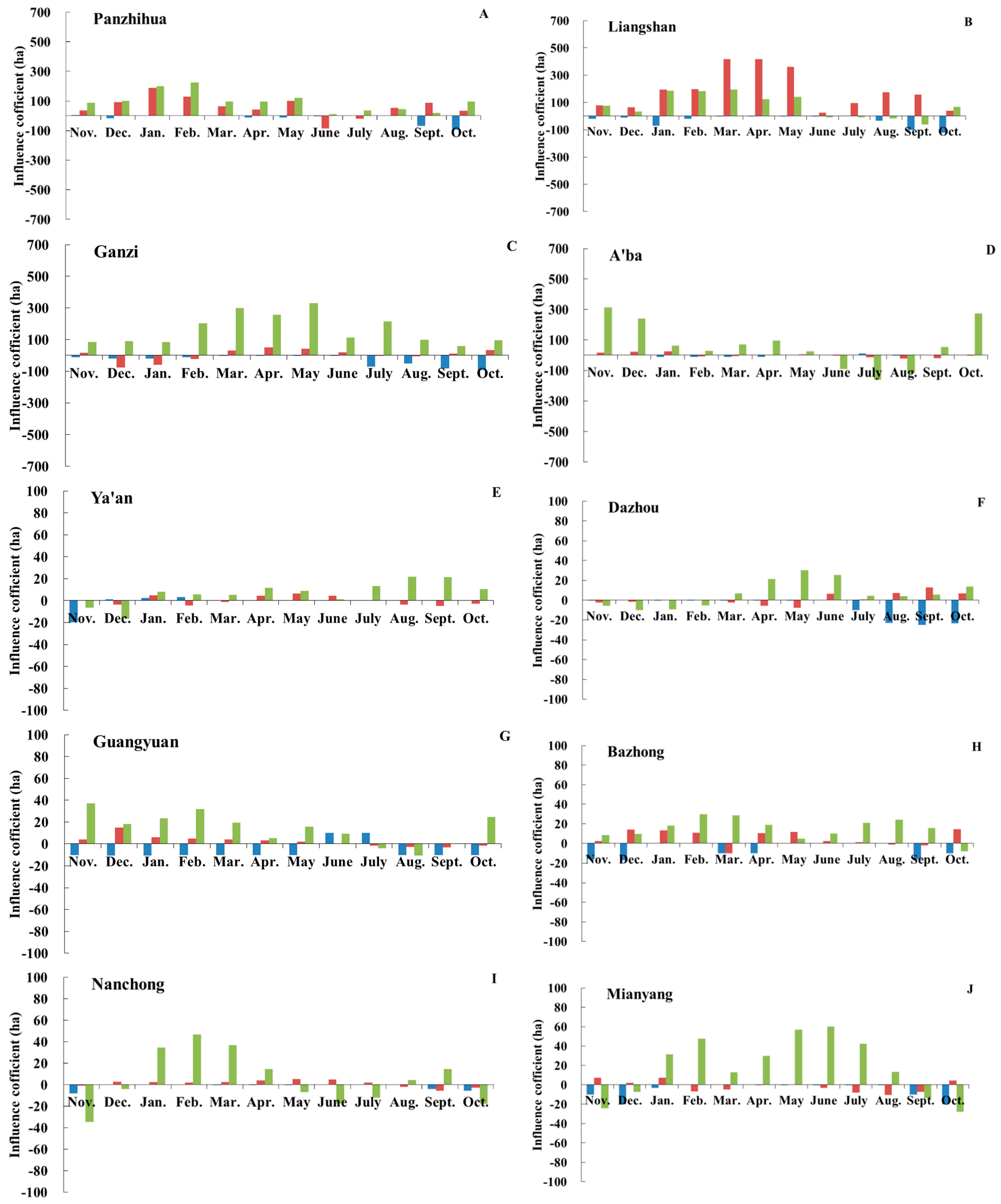
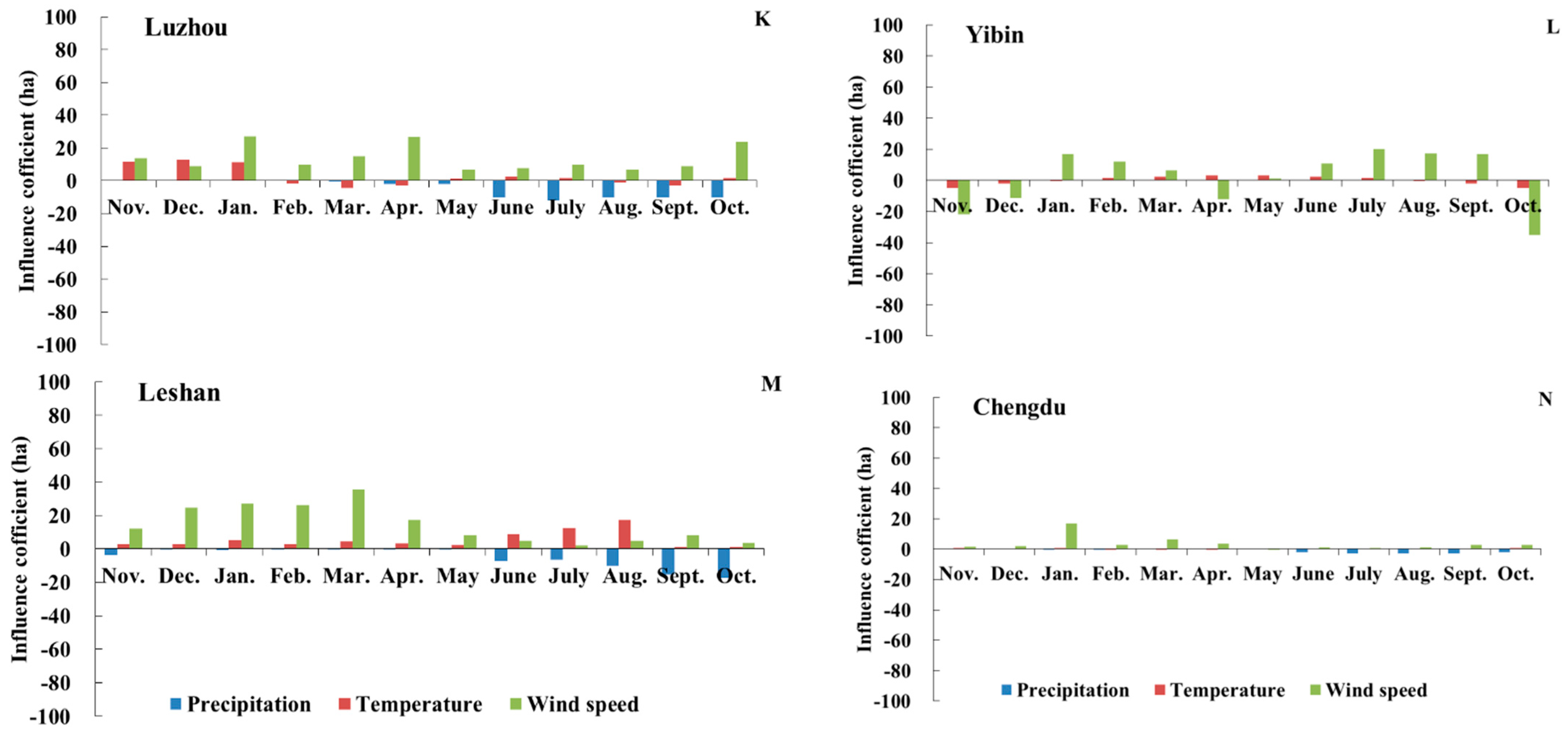
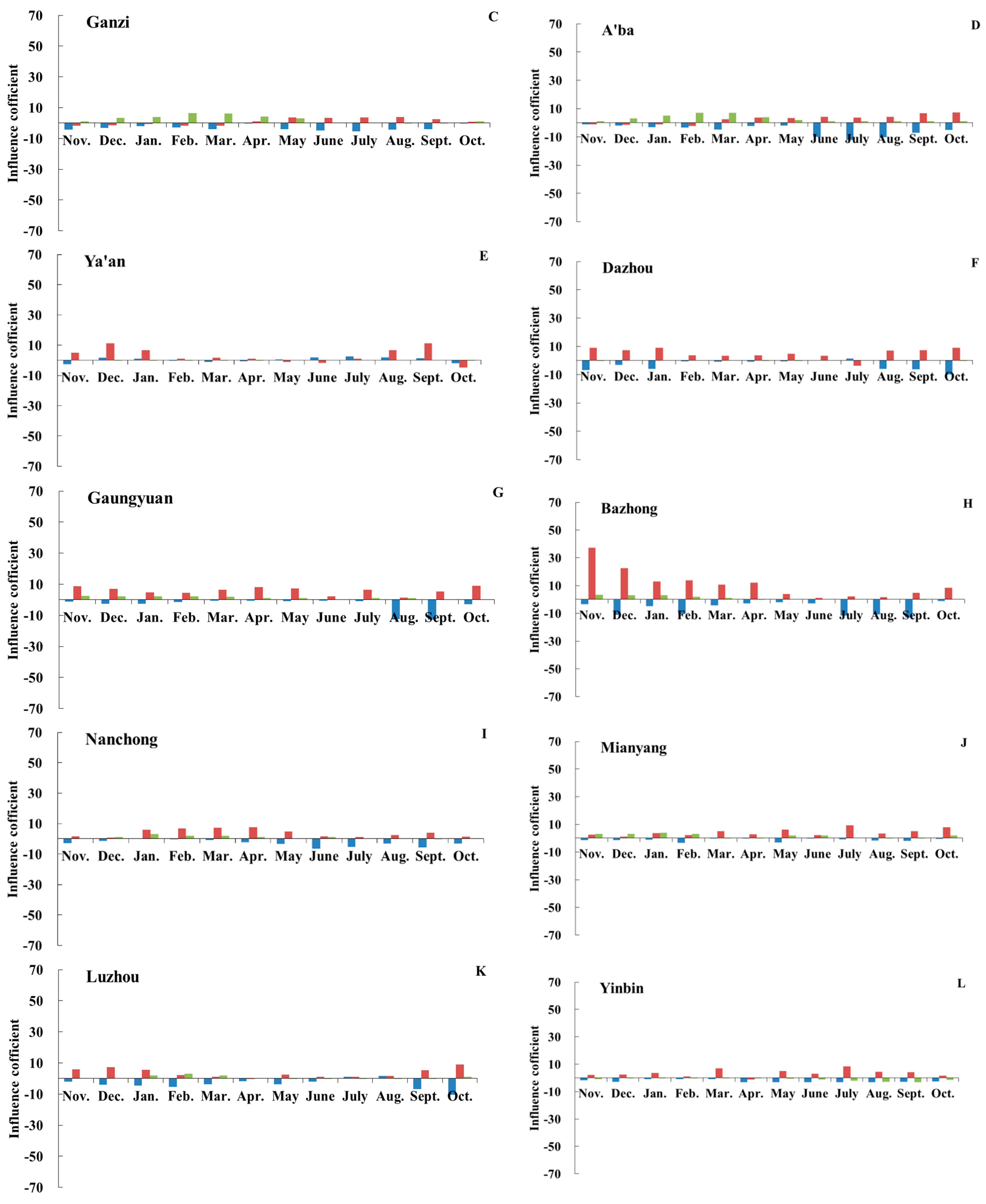
3.2. The Influence of Meteorological Factors on Forest Fires

Temperature and precipitation affect the moisture content of fuel and the distribution of vegetation, influencing the occurrence and development of forest fires. Wind speed is the decisive factor that restricts the rate of spread, fire intensity, area burned and fighting difficulty of forest fires. Figure 3 and Figure 4 show that the influence coefficients of wind speed, temperature and precipitation from January to December and their leading roles were different in the grade I wildfire danger region of the Sichuan province. The impact on the number and areas burned by forest fires in different climatic regions varied and the dominant meteorological factors were constantly changing. In a given period, it was mainly affected by temperature while in other periods it was affected by precipitation or wind speed. The increase or decrease in the number and area burned due to the influence of wind speed, temperature and precipitation depended on meteorological factors that played a leading role for a given month or on the results of the interaction among precipitation, temperature and wind speed. There were differences in the responses of the number and area burned to monthly changes of wind speed, temperature and precipitation in the same administrative region.
At the same time, Figure 3 clearly illustrates that the influence of monthly dynamic changes in wind speed, temperature and precipitation on the area burned and number of forest fires in the Sichuan province was both regular and different. All administrative regions were affected by precipitation, temperature and wind speed, indicating that the changes of wind speed, temperature and precipitation were closely related to the number of fires and the area burned. During the fire prevention period (November to May of the following year), the area burned was more sensitive to wind speed changes in winter and spring and was especially positively correlated with wind speed. At the same time, abundant precipitation in the autumn directly affected the area burned, which demonstrated that the precipitation effect exhibited a lag. The number of forest fires was more affected by temperature than by precipitation and was closely related to changes in precipitation and temperature during the dry-wet transition period in the autumn.
During the study period, the number of fires in Panzhihua and Liangshan (with a semi-humid subtropical, mountain climate) was mainly affected by temperature while the synergistic effect of wind speed impacted the area burned. There was a short intermission period in November and December. After that, both the number and area burned increased significantly until the end of the fire prevention period (Figure 3A,B and Figure 4A,B). This also showed a lag in the impact of precipitation in the autumn on fire. During this study, if the average monthly temperature increased by 1 °C, precipitation increased by 1 mm and wind speed increased by 1 m·s−1, the number of forest fires increased three times and the area burned increased by 130 and 134 ha in November, respectively.
In Ganzi and A’ba (with a plateau cold mountain climate), wind speed was the main factor causing the fluctuation of the area burned (Figure 3C,D) and the number clearly responded to precipitation (Figure 4C,D). This area was the largest part of the study area with an annual average wind speed of 1.85 m·s−1 and the seasonal difference was clear: the annual average wind speed was 2.18 m·s−1 in winter and spring and the minimum was 1.13 m·s−1 in summer. It had the least precipitation with an annual average rainfall of 714.52 mm in the Sichuan province and the monthly average rainfall during the fire prevention period was only 26.95 mm. With the increase of the autumn precipitation, the number of forest fires decreased in November and December, which also showed a lag in the impact of precipitation on forest fires. When the temperature increased by 1 °C, wind by 1 m·s−1 and precipitation by 1 mm, the area burned changed dramatically in November (Figure 3D) with an increase of 334 ha in Ganzi. Therefore, the risk of major forest fires is high once a forest fire has occurred.
The response of forest fires to climatic factors in the basin climate region was regular and also different. The main factor controlling the number in the Chengdu basin and its eastern region (Nanchong, Dazhou, Bazhong, Mianyang, Guangyuan and Ya’an) was temperature, particularly in the Bazhong region. Zhang et al. (2010) found that the temperature has increased by 0.3 °C on average over the past 15 years and annual precipitation has decreased at a rate of 13.813 mm/10a in Bazhong, which may be one of the reasons for the increase in fire numbers in recent years [38]. The number of forest fires in southern Chengdu (including Yibin, Luzhou and Leshan) was the result of the synergy among temperature, precipitation and wind speed. Similar to the other two climatic regions, wind speed played a leading role in the area burned in this region as well. During this study, if the average monthly temperature increased by 1 °C, precipitation increased by 1 mm and wind speed increased by 1 m·s−1, the annual fire number in total increased three-fold and the area burned increased by 100 ha in the entire basin climate region. Therefore, with an increasing impact of global climate change, the region will gradually become a focus for forest fire prevention and control in the Sichuan province.

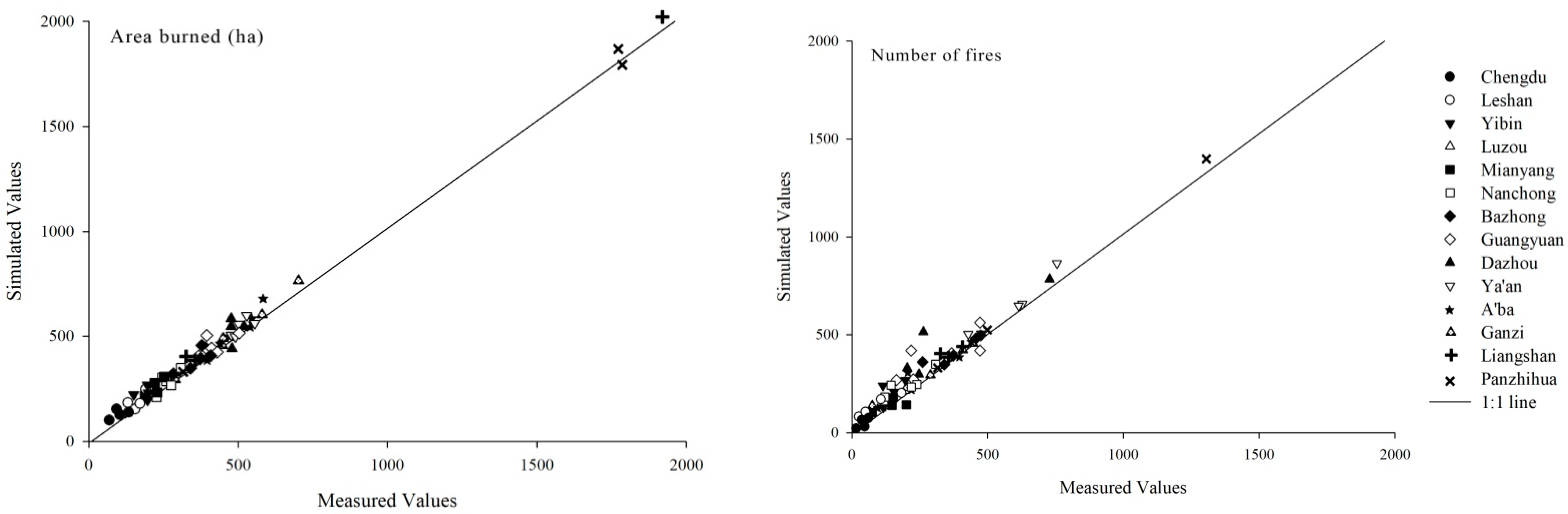
3.3. An Integral Regression Model for the Number and Area Burned

Table 1 summarizes that the coefficients of determination (R2) of the fitting function for the number and area burned in each administrative region were greater than 0.900. With the exception of the poor effect of the model significance in Chengdu, the other city models passed the significance test of p < 0.05, which showed that the integral regression model showed a high accuracy in establishing a multivariate model for a forest fire response to climate change. Figure 5 shows that the difference between the simulated and measured values of the integral regression model was small and basically distributed on or near the 1:1 line; however, the predicted values were slightly larger. The results showed that the integral regression was reliable for studying the response of the number and area burned to the changes of multi-meteorological elements in different months over 14 grade I forest fire danger regions in the Sichuan province and it could be used to predict the response of forest fires to future climate change.

4. Discussion and Conclusions

In this study, the number of forest fires and the area burned along with influencing factors were analyzed by using an integral regression based on forest fire data and meteorological data for every month from 1984 to 2011. The results showed that areas with a high incidence of forest fires in the Sichuan province included the Ganzi, Liangshan, Panzhihua and A’ba areas, in particular, including the total number of fires and the total area burned due to the influence of a 1 °C rise in air temperature, a 1 m·s−1 rise in wind speed and a 1 mm increase in precipitation on the number of forest fires in a grade I forest fire danger region of the Sichuan province. Zhao (2005) also considered the climate anomalies caused by global warming that have aggravated the occurrence and development of forest fires in middle and low altitudes and also reported that these anomalies continue to increase [39]. Honnay et al. (2010) investigated and reported that global circulation models have predicted an increase in the mean annual temperature between 2.1 and 4.6 °C by 2080 in the northern temperate zone [40]; this undoubtedly will exacerbate the outbreak of forest fires. In general, forest fires were found to be closely related to wind speed, precipitation and temperature; nonetheless, several differences were observed across the climatic regions. Temperature played a dominant role in Panzhihua and Liangshan with their semi-humid, subtropical mountain climate while Ganzi and A’ba with a plateau cold mountain climate were more sensitive to wind speed. In the basin area with Chengdu as the center, temperature was the main factor or the result of the synergy of temperature, precipitation and wind speed. This proved that the impact of an increasing wind speed was more severe on high altitude areas than on low altitude areas and the fire danger rating in a higher altitude area was more severe. Zhao (2005) also came to the same conclusion [39]. At the same time, the abrupt change of precipitation in dry and wet seasons and the influence of precipitation in the autumn on the area burned were more significant than the number of fires, which also proved that precipitation exhibits a lag effect on forest fires.
Temperature is an important factor for forest fires to occur [16,32]. The frequency was the highest in the Panzhihua and Liangshan areas; however, temperature was the main controlling factor. Both the frequency and area were not the largest but there has been an upward trend in recent years with Chengdu as the center. Lu (2011) reached the same conclusion by following another method and revealed that forest fires increased with the decrease of precipitation and the increase of temperature and there was a positive correlation between the forest fire area in southwest China (R = 0.327, p < 0.05) [41]. Moreover, Guan et al. (2018) concluded that the number of particularly serious forest fires was the highest when the temperature was in the range of 16–20 °C [42]. The annual average temperature in Panzhihua was the highest in the Sichuan province, particularly in the valley area where temperatures were between 19 and 21 °C and the average temperature in the Liangshan area was 17.16 °C. Furthermore, Zeng et al. (2013) showed that the temperature of the Liangshan Prefecture increased significantly in each season, particularly in winter (+0.8 °C), spring (+0.7 °C) and the autumn (+0.6 °C) based on annual, seasonal and monthly average temperature and precipitation records from 1961 to 2010 [43]. These may be the meteorological reasons for the larger number and area burned by forest fires in the two regions. Furthermore, Zhang et al. (2020) analyzed the characteristics of a total of 56 years of daily maximum temperatures, minimum temperatures, precipitation and average temperature data for 12 observation stations in the Chengdu plain from 1961 to 2016 based on M–K tests and found that temperature first decreased and then increased [44]. It continued to increase with fluctuation; the temperature was slightly higher to the east and southeast and the interannual precipitation in the Chengdu plain decreased with a large interannual fluctuation. Chen et al. (2011) found that precipitation in most areas of the basin decreased based on the daily meteorological data from 36 meteorological stations from 1961 to 2009 [45]. The increase of temperature and the decrease of precipitation directly reduced the forest fuel moisture and the synergistic effect of temperature, precipitation and wind speed would further increase the risk of the number of fires in Chengdu and its surrounding areas. However, the influence of temperature was slightly higher. It may be related to complex landforms and climatic conditions.
Wind speed is also a non-negligible component of forest fires. In this study, the area burned was affected by wind speed in three climatic regions, particularly in Ganzi and A’ba. The average wind speed in A’ba and Ganzi reached 2.18 m·s−1 during the fireproof period (from November and May the next year). Other scholars have proven that the area burned can reach a maximum when the wind speed exceeds 2 m·s−1. For instance, the relationship between particularly serious forest fires and meteorological factors in the Jilin province was studied by Guan et al. (2018) and they demonstrated that wind speeds at levels of 3–5 could contribute to particularly serious forest fires and the fire number and the area of serious fires were the highest when wind speed was at level 4 [42]. He (2018) pointed out that forest fires occurred most frequently at a 2 m·s−1 wind speed based on forest fire data, meteorological data and spatial data from Guangxi from 2011 to 2015 [46]. Lasslop et al. (2015) considered other drivers and confirmed the increase in the area burned with an increasing wind speed up to a certain threshold. They found that the area burned peaked with mean wind speeds of about 2 m·s−1 [23]. Dimitrakopoulos (2002) classified forest fires according to the prevailing conditions of air temperature, relative humidity, wind speed, wind direction, elevation, aspect and slope from 1980–1997 in Greece and showed that two-thirds (66.94%) of total fires occurred under a moderate wind speed (1–4 BF) and the fires (18.2%) that burned under strong winds (5–7 BF) were responsible for most of the area burned (43.16%) [47].
In addition to meteorological factors, forest fires are also affected by many other factors such as forest fuels, vegetation type, economics, landforms and physiognomy, the distribution of population and the national structure [9,16,22]. He (2018) pointed out that a larger minority population led to higher proportions of forest fires in ethnic autonomous regions based on the forest fire data, meteorological data and spatial data of Guangxi from 2011 to 2015 [46]. Wang et al. (2012) also showed that the top three impact factors were the road factor, population quality and residential factor by following the AHP method of Panzhihua city. The Sichuan province is the largest Yi inhabited area, the second largest Tibetan area and the only Qiang inhabited area in China; thus, the impact of human activities on forest fires is an important research direction in the future [48].
Owing to the complex terrain, complex and diverse vegetation types and clear microclimates in Sichuan, a regional three-dimensional climate has been formed. Regional precipitation fluctuates significantly and the seasonal differences are obvious. Therefore, it was a great challenge to accurately predict forest fire disasters due to the lack of future climate change predictions. There were many climatic factors that impacted forest fires; thus, it was necessary to consider the influence of many factors comprehensively. However, at the background of global warming, the research community together with the fire service (in particular, in counties heavily affected by wildfires) has begun to realize that landscape management may be the only viable tactic toward fire safety [49,50]. Although the simulation results of the model were good, the importance of interactions among other factors (such as topography, vegetation, type and continuity of fuel and population) remains unknown [4,6,51]. Undeniably, many more systematic explorations are still demanded to investigate how to use integral regression to analyze the response of forest fires to various climatic and biological factors and characteristics of synergistic change. It is also an important aspect of our future study based on the Canadian Fire Weather Index and other theoretical bases.

Author Contributions

Data curation, S.W.; Formal analysis, S.N.; Investigation, S.W.; Methodology, H.L.; Software, S.W. All authors have read and agreed to the published version of the manuscript.

Funding

This research was funded by The Philosophy and Social Science Program of Qingdao, China, grant number QDSKL2001226.

Institutional Review Board Statement

Not applicable.

Informed Consent Statement

Not applicable.

Data Availability Statement

Not applicable.

Conflicts of Interest

The authors declare no conflict of interest.

References

  1. Oddi, F.; Ghermandi, L.; Lasaponara, R. Annual Burned Area across a Precipitation Gradient in Northwestern Patagonia Steppe; Egu General Assembly: Vienna, Austria, 2013. [Google Scholar]
  2. Wang, S.; Niu, S. Fuel classes in conifer forests of southwest sichuan, china, and their implications for fire susceptibility. Forest 2016, 7, 52. [Google Scholar] [CrossRef] [Green Version]
  3. Hall, S.; Burke, I.; Box, D.; Kaufmann, M.; Stoker, J. Estimating stand structure using discrete-return lidar: An example from low density, fire prone ponderosa pine forests. For. Ecol. Manag. 2005, 208, 189–209. [Google Scholar] [CrossRef]
  4. de Luis, M.; Baeza, M.; Raventos, J.; Hidalgo, J.C.G. Fuel characteristics and fire behaviour in mature Mediterranean gorse shrublands. Int. J. Wildland Fire 2004, 13, 79. [Google Scholar] [CrossRef] [Green Version]
  5. Chernkhunthod, C.; Hioki, Y. Fuel characteristics and fire behavior in mixed deciduous forest areas with different fire frequencies in Doi Suthep-Pui National Park, Northern Thailand. Landsc. Ecol. Eng. 2020, 16, 289–297. [Google Scholar] [CrossRef]
  6. Van de Water, K.; North, M. Stand structure, fuel loads, and fire behavior in riparian and upland forests, Sierra Nevada Mountains, USA; a comparison of current and reconstructed conditions. For. Ecol. Manag. 2011, 262, 215–228. [Google Scholar] [CrossRef]
  7. Wang, S.; Niu, S. Do biological invasions by Eupatorium Adenophorum increase forest fire severity? Biol. Invasions 2016, 18, 717–729. [Google Scholar] [CrossRef]
  8. Vélez, R. High intensity forest fires in the Mediterranean Basin: Natural and socioeconomic causes. Disaster Manag. 1993, 5, 16–20. [Google Scholar]
  9. Ying, L.; Han, J.; Du, Y.; Shen, Z. Forest fire characteristics in China: Spatial patterns and determinants with thresholds. For. Ecol. Manag. 2018, 424, 345–354. [Google Scholar] [CrossRef]
  10. Holden, Z.A.; Jolly, W.M. Modeling topographic influences on fuel moisture and fire danger in complex terrain to improve wildland fire management decision support. For. Ecol. Manag. 2011, 262, 2133–2141. [Google Scholar] [CrossRef]
  11. Lahaye, S.; Sharples, J.; Matthews, S.; Heemstra, S.; Price, O.; Badlan, R. How do weather and terrain contribute to firefighter entrapments in Australia? Int. J. Wildland Fire 2018, 27, 85. [Google Scholar] [CrossRef]
  12. Gómez-Nieto, I.; del Martín, M.P.; Salas, F.J.; Gallardo, M. Analysis of Historical Forest Fire Regime in Madrid Region (1984–2010) and ITS Relation with Land-Use/Land-Cover Changes; EGU General Assembly: Vienna, Austria, 2013; Available online: https://2013EGUGA.15.8073G (accessed on 20 October 2020).
  13. Stocks, B.J.; Fosberg, M.A.; Lynham, T.J.; Mearns, L.; Wotton, B.M.; Yang, Q.; Jin, J.-Z.; Lawrence, K.; Hartley, G.R.; Mason, J.A.; et al. Climate Change and Forest Fire Potential in Russian and Canadian Boreal Forests. Clim. Chang. 1998, 38, 1–13. [Google Scholar] [CrossRef]
  14. Fill, J.M.; Davis, C.N.; Crandall, R.M. Climate change lengthens southeastern USA lightning-ignited fire seasons. Glob. Chang. Biol. 2019, 25, 3562–3569. [Google Scholar] [CrossRef]
  15. Boucher, D.; Gauthier, S.; Thiffault, N.; Marchand, W.; Girardin, M.; Urli, M. How climate change might affect tree regeneration following fire at northern latitudes: A review. New For. 2020, 51, 543–571. [Google Scholar] [CrossRef] [Green Version]
  16. Agovino, M.; Cerciello, M.; Ferraro, A.; Garofalo, A. Spatial analysis of wildfire incidence in the USA: The role of climatic spillovers. Environ. Dev. Sustain. 2021, 23, 6084–6105. [Google Scholar] [CrossRef]
  17. Mariani, M.; Holz, A.; Veblen, T.T.; Williamson, G.; Fletcher, M.; Bowman, D.M.J.S. Climate change amplifications of climate-fire teleconnections in the Southern Hemisphere. Geophys. Res. Lett. 2018, 45, 5071–5081. [Google Scholar] [CrossRef]
  18. Gu, X.L.; Wu, Z.W.; Zhang, Y.J.; Yan, S.J.; Fu, J.J.; Du, L.H. Prediction research of the forest fire in Jiangxi province in the background of climate change. Acta Ecol. Sin. 2020, 40, 667–677. [Google Scholar]
  19. Mokhov, I.; Chernokulsky, A. Regional model assessments of forest fire risks in the Asian part of Russia under climate change. Geogr. Nat. Resour. 2010, 31, 165–169. [Google Scholar] [CrossRef]
  20. Chen, F.; Niu, S.; Tong, X.; Zhao, J.; Sun, Y.; He, T. The impact of precipitation regimes on forest fires in Yunnan province, southwest China. Sci. World J. 2014, 2014, 1–9. [Google Scholar] [CrossRef] [PubMed] [Green Version]
  21. Groisman, P.Y.; Knight, R.W.; Heim, R.R.; Razuvaev, V.N.; Alexandersson, H. Changes in Climate, Potential Forest Fire Danger, and Land Use in High Latitudes of the Northern Hemisphere; American Geophysical Union: Washington, DC, USA, 2004. [Google Scholar]
  22. Wotton, B.M.; Nock, C.A.; Flannigan, M. Forest fire occurrence and climate change in Canada. Int. J. Wildland Fire 2010, 19, 253–271. [Google Scholar] [CrossRef]
  23. Lasslop, G.; Hantson, S.; Kloster, S. Influence of wind speed on the global variability of burned fraction: A global fire model’s perspective. Int. J. Wildland Fire 2015, 24, 989–1000. [Google Scholar] [CrossRef]
  24. Varela, V.; Vlachogiannis, D.; Sfetsos, A.; Karozis, S.; Politi, N.; Giroud, F. Projection of forest fire danger due to climate change in the french mediterranean region. Sustainability 2019, 11, 4284. [Google Scholar] [CrossRef] [Green Version]
  25. McKenzie, D.; Gedalof, Z.; Peterson, D.L.; Mote, P. Climatic change, wildfire, and conservation. Conserv. Biol. 2004, 18, 890–902. [Google Scholar] [CrossRef]
  26. Cheng, M.L. The Integration Regression Model for Economic Forecasting. Forecasting 2001, 20, 73–75. [Google Scholar]
  27. Xu, G.X.; Luo, S.X.; Guo, Q.S.; Pei, S.X.; Shi, Z.M.; Zhu, L.; Zhu, N.N. Responses of leaf unfolding and flowering to climate change in 12 tropical evergreen broadleaf tree species in Jianfengling, Hainan Island. Chin. J. Plant Ecol. 2013, 28, 799–811. [Google Scholar]
  28. Qiu, X.Q.; Jiang, X.D. Application of regression-integral in the research of relationships between tree growth and climate. J. Fujian Coll. For. 1989, 9, 418–422. [Google Scholar]
  29. Jiang, X.D.; Qiu, X.Q.; Dong, X.E. Growth prediction of the relationship between annual growth of trees and climate base on Regression-Integral. In Central South Forest Inventory and Planning; State Forestry Administration: Beijing, China, 1990; pp. 28–31. [Google Scholar]
  30. Wu, Z.D.; Wang, C.D.; Li, Q.; Liu, M. Crown profile and volume compatibility model of Cunninghamia lanceolata in Fujian Province. J. Zhejiang A F Univ. 2020, 37, 114–121. [Google Scholar]
  31. Wang, Y. The area burned and damage area of forest fire was “three decrease” of Sichuan province in 2019. Gree Tianfu. 2020, 2, 36–39. [Google Scholar]
  32. Li, D. Relationship of Forest Fires and Meteorological Factors in Key Region of Sichuan Province; Beijing Forestry University: Beijing, China, 2013. [Google Scholar]
  33. Ding, Z.L.; Yuan, F.; Chen, Z.; Tan, J.B. Error Theory and Data Processing, 2nd ed.; Harbin Institute of Technology Press: Harbin, China, 2002. [Google Scholar]
  34. Xu, J.H. Quantitative Geography; Higher Education Press: Beijing, China, 2006. [Google Scholar]
  35. Zhou, C.Y.; Cen, S.X.; Li, Y.Q.; Peng, G.Z.; Yang, S.Q.; Peng, J. Precipitation Variation and Its Impacts in Sichuan in the Last 50 Years. Acta Geogr. Sin. 2011, 66, 619–630. [Google Scholar]
  36. Zhang, F.C. Statistic analysis on the phenophase of trees in spring of Beijing. Geogr. Res. 1983, 2, 55–64. [Google Scholar]
  37. Pang, W. Climate change in Ya’an city from 1961 to 2010. J. Guizhou Meteorol. 2012, 36, 40–42. [Google Scholar]
  38. Zhang, L.; Xiao, T.G.; Yan, Y.F.; Zhang, H.; Zhong, X. Analysis on the characteristics of climate change in Bazhong Si-chuan province in recent 38 years. J. Chengdu Univ. Inf. Technol. 2010, 25, 293–300. [Google Scholar]
  39. Zhao, X.M. Study on the Prevention and Extinguishing Methods of Summer Forest Fire in Summer of Daxinganling Forest Region; Northeast Forestry University: Harbin, China, 2005. [Google Scholar]
  40. Honnay, O.; Verheyen, K.; Butaye, J.; Jacquemyn, H.; Bossuyt, B.; Hermy, M. Possible effects of habitat fragmentation and climate change on the range of forest plant species. Ecol. Lett. 2002, 5, 525–530. [Google Scholar] [CrossRef]
  41. Lu, A.F. Study on the relationship among forest fire, temperature and precipitation and its spatial-temporal variability in China. Agric. Sci. Technol. 2011, 12, 1396–1400. [Google Scholar]
  42. Guan, S.; Liu, H.Y.; Gao, B.; Han, X.Y.; Shan, T.L.; Du, S.; Yin, S.N. Relationship of Particularly Serious Forest Fires and Meteorological Factors in Jilin Province. J. Southwest For. Univ. 2018, 38, 168–172. [Google Scholar]
  43. Zeng, W.Q.; Xu, D.M.; Fan, W. Analysis of climate change characteristics in Liangshan Prefecture in the past 50 year. In Proceedings of the Plateau Mountain Meteorological Research and Southwest Regional Meteorological Academic Exchange Meeting in 2013, Guiyang, China, 10–11 October 2013. [Google Scholar]
  44. Zhang, L.Y.; Mao, W.S.; Pang, B. Characteristics of Climate Change in Chengdu Plain. J. Chengdu Univ. Inf. Technol. 2020, 35, 179–187. [Google Scholar]
  45. Chen, C.; Pang, Y.M.; Pan, X.B.; Zhang, D.F. Characteristics of climate resources under global climate change in Sichuan province. Resour. Sci. 2011, 33, 1310–1316. [Google Scholar]
  46. He, Y. Occurrence Regularity of Forest Fire in Guangxi and Its Correlation with Meteorological Factors; Central South University of Forestry and Technology: Changsha, China, 2018; pp. 1–2. [Google Scholar]
  47. Dimitrakopoulos, A.P. Distribution of forest fires and area burned according tometeorological and topographic factors in Greece. In Proceedings of the Forest Fire Research and Wildland Fire Safety: Proceedings of IV International Conference on Forest Fire Research 2002 Wildland Fire Safety Summit, Luso, Coimbra, Portugal, 18–23 November 2002. [Google Scholar]
  48. Wang, J.H.; Niu, S.K.; Li, D.; Wang, S.; Chen, F. Research on the spatial distribution of forest fires in Sichuan province. Guangdong Agric. Sci. 2012, 233–236. [Google Scholar]
  49. Moya, D.; Certini, G.; Fulé, P.Z. Fire regime and ecosystem responses: Adaptive forest management in a changing world (Part 1). Int. J. Wildland Fire 2019, 28, 471–472. [Google Scholar] [CrossRef] [Green Version]
  50. Lynch, J.A.; Hollis, J.L.; Feng, S.H. Climatic and landscape controls of the boreal forest fire regime: Holocene records from Alaska. J. Ecol. 2004, 92, 477–489. [Google Scholar] [CrossRef]
  51. Cruz, M.G.; Alexander, M.E.; Wakimoto, R.H. Assessing canopy fuel stratum characteristics in crown fire prone fuel types of western North America. Int. J. Wildland Fire 2003, 12, 39–50. [Google Scholar] [CrossRef] [Green Version]
Figure 1. Study area.
Sustainability 13 07773 g001
Figure 2. The changing trend of the number of fires and area burned in the grade I wildfire danger region of the Sichuan province during the period 1984–2011.
Sustainability 13 07773 g002aSustainability 13 07773 g002b
Figure 3. The influences of a 1 °C rise in air temperature, a rise in 1 m·s−1 in wind scheme 1 mm increase in precipitation on the area burned of forest fires in a grade I forest fire danger region of the Sichuan province.
Sustainability 13 07773 g003aSustainability 13 07773 g003b
Figure 4. The influences of a 1 °C rise in air temperature, a rise in 1 m·s−1 in wind Scheme 1 mm increase in precipitation on the number of forest fires in a grade I forest fire danger region of the Sichuan province.
Sustainability 13 07773 g004aSustainability 13 07773 g004bSustainability 13 07773 g004c
Figure 5. Comparison between the measured and modeled values of 14 grade I forest fire danger regions in the Sichuan province based on an integral regression model.
Sustainability 13 07773 g005
Table 1. Integral regression model of the area burned and number of forest fires of 14 regions.
Region Integral Regression ModelR2p
PanzhihuaArea burnedy = 167.2250 + 0.0254T1 + 0.1927T3 − 0.3553P2 − 0.6538P4 + 4.0347WS0 + 3.6740WS40.99670.0001
Number of fires y = 43.2114 + 3.0319T0 + 2.1809T2 + 1.0007T5 − 0.0067P3 + 0.0634WS10.99810.0002
LiangshanArea burnedy = 274.9370 + 0.1859T0 + 1.1990T2 − 0.7153P3 − 0.1460P5 + 2.1770WS1 + 5.1770WS30.99000.0004
Number of firesy = −41.8700 + 2.0275T1 + 2.6875T3 0.6800P3 0.1809P4 − 0.1612P5 + 0.0065WS30.99310.0005
GanziArea burnedy = 200.6600 + 0.0181T0 + 0.0675T4 0.0861P4 + 9.3573WS0 + 8.0212WS3 + 6.142WS40.99910.0023
Number of firesy = −9.4317 + 0.6994T1 + 0.3182T3 3.3573P0 2.4231P2 + 0.0174WS50.99920.0019
A’baArea burnedy = 132.8521 + 0.3772T1 + 0.2290T5 1.7228P3 1.9472P5 + 5.4998WS0 + 9.4841WS10.99780.0001
Number of firesy = −2.3857 + 0.0246T0 + 0.0509T4 3.1362P1 2.2360P4 + 0.0053WS1 + 0.0502WS50.99560.0001
Ya’anArea burnedy = 70.1155 + 0.3200T0 0.3300P0 0.0544P3 + 1.9939WS40.99980.0002
Number of firesy = 8.6500 + 0.3253T0 1.0261P3 + 0.0175WS0 + 0.0208WS50.99570.0001
DazhouArea burnedy = 6.6421 + 0.9502T1 + 0.7562T3 0.0295P0 0.0155P3 + 0.2467WS2 + 0.0862WS50.99980.0004
Number of firesy = 24.2100 + 3.6677T0 + 1.5600T2 + 0.2300T4 1.001P3 0.0095P4 + 0.0541WS0 + 0.WS40.99970.0003
GuangyuanArea burnedy = 117.4290 + 0.9313T1 + 1.7334T3 0.3009P3 0.4663P5 + 0.8553WS2 + 0.0368WS50.99950.0002
Number of firesy = 48.1379 + 0.0745T0 + 0.4673T5 0.2009P2 0.0301P4 0.003P5 + 0.1475WS30.99870.0018
BazhongArea burnedy = 169.3035 + 0.2538T3 + 0.1108T5 0.7263P0 0.7159P4 + 2.5576WS2 + 1.9237WS50.99970.0023
Number of firesy = 66.9078 + 0.2158T3 + 1.9512T5 0.4178P0 1.0154P3 + 0.7424WP40.99950.0017
NanchongArea burnedy = 54.7800 + 0.8065T0 + 0.2228T3 0.6244P1 0.3348P3 + 1.8859WS2 + 2.5352WS50.99960.0023
Number of firesy = 23.100 + 0.7300T1 + 0.2234T4 0.3001P4 0.4501P5 + 0.2998WS40.99940.0020
MianyangArea burnedy = 137.9300 + 0.2397T0 + 0.0374T3 0.3457P2 0.0234P5 + 0.9901WS1 + 1.0901WS10.99950.0019
Number of firesy = 53.2300 + 0.9099T2 + 0.0801T3 0.0342P2 0.0789T4 + 0.5698WS30.99910.0018
LuzhouArea burnedy = 65.8439 + 0.0038T2 + 0.0369T3 0.7203P2 0.5118P5 + 2.0426WS2 + 0.7255WS50.99970.0001
Number of firesy = 8.9971 + 0.3435T3 + 0.3755T5 0.0426P2 0.0947P5 + 0.5856WS30.99980.0001
YibinArea burnedy = 21.4600 + 0.0900T0 + 0.0844T3 0.5589WS1 + 2.2310WS30.99960.0021
Number of firesy = 1.1100 + 0.0788T0 + 0.1238T4 0.4579P3 0.0079P5 + 0.1129WS00.99930.0018
LeshanArea burnedy = 70.1155 + 0.03053T2 + 0.4590T5 0.0304P3 0.0123P5 + 2.0978WS40.99950.0019
Number of firesy = 33.1100 + 0.1124T1 + 0.2314T4 0.0897P0 0.2398P3 + 0.1123WS30.99970.0015
ChengduArea burnedy = 25.5379 + 1.6466T0 + 0.7584 T2 0.2901P2 + 6.4084WS2 + 3.6583WS3 + 2.7286WS50.95300.0789
Number of firesy = 48.1139 + 7.0694T1 + 6.487T3 + 8.8075 T5 4.0083P1 − 3.0083P2 + 4.7307WS2 + 0.9664WS30.94610.0889
Note: p-values indicate the significance based on an F-test. Pj is a new variable indicating that the original monthly precipitation was formed by jth orthogonal transformations. Tj is a new variable indicating that the original monthly precipitation was formed by jth orthogonal transformations. WSj is a new variable indicating that the original monthly precipitation was formed by jth orthogonal transformations.
Publisher’s Note: MDPI stays neutral with regard to jurisdictional claims in published maps and institutional affiliations.

