
Counter-Mapping through Digital Tools as an Approach to Urban History: Investigating the Spatial Condition of Activism †


Interuniversity Department of Regional and Urban Studies and Planning (DIST), Politecnico di Torino, Viale Pier Andrea Mattioli, 39, 10125 Torino, Italy
†
An earlier draft of this paper has been presented at the International Conference ‘Grand Projects—Urban Legacies of the Late 20th Century, that took plane online between 17 and 19 February 2021.
Sustainability 2021, 13(16), 8904; https://0-doi-org.brum.beds.ac.uk/10.3390/su13168904
Submission received: 24 May 2021
/
Revised: 27 June 2021
/
Accepted: 5 August 2021
/
Published: 9 August 2021
(This article belongs to the Special Issue Urban Legacies of the Late 20th Century)
Abstract
:Cultural heritage has a central role in sustainable development, and it has the potential to re-imagine more democratic cities. Yet, critical theory has framed cultural heritage not only as the material remains of the past, but also as a dynamic interaction of humans with their past that encompasses tangible and intangible entities. Thus, it is necessary to research these dynamics to understand the role of cultural heritage as a resource for sustainable development. In this context, the main research question of this article is: “How does heritage is shaped and managed by the ‘present’? Can we understand this process through the opportunities of digital humanities?”. To confront this question, the research adapts the counter-mapping methodology with the digital humanities perspective focusing on the urban protest movements that took place in the historic areas of Istanbul throughout the 1960s. It is seen that the spatial pattern of these movements was the result of the urban operations of the 1950s. In the 1950s, an autocratic government shaped the urban space and redefined the urban heritage to concentrate more power. However, in the 1960s, workers and students used the very same spaces and again redefined the urban heritage by exercising their social rights. Based on these results, the main conclusion is that for revealing the full potential of cultural heritage in sustainable development, it is necessary to deepen our knowledge on how heritage operates in a society, considering that heritage changes meaning depending on the socio-political context of the period.
1. Introduction
The role of cultural heritage in achieving sustainable development is highlighted in the UN SDGs (Goal 11, Target 11.4: “Strengthen efforts to protect and safeguard the world’s cultural and natural heritage”) [1]. The Council of Europe also recognized “the key role of cultural heritage in promoting peace, democracy and sustainable development” [2], and the European Framework for Action framed the role of cultural heritage “as a shared resource, raising awareness of common history and values, and reinforcing a sense of belonging to a common European cultural and political space” [3]. Within this framework, the concept of “urban heritage” has gradually become more integrated in the frameworks provided by the UN International Development Agenda [4]. The main research hypothesis of this article is that in addition to individual and social well-being (as outlined in the European policy documents), cultural heritage, particularly urban heritage, can play a bigger role in re-imagining more democratic cities, where power is distributed more equally. In order to reveal this potential or urban heritage, in line with the state of the art in heritage studies (which will be elaborated on below), we need to perceive heritage not as static tangible material remains of the past but rather as a process, a continuous living dynamic interaction of humans with their past that encompasses tangible and intangible entities.
The idea of framing cultural heritage not as “things” but rather as “processes” is a development that came with a critical perspective toward cultural heritage that has developed at least since the 1980s. Even though David Lowenthal’s seminal work ‘The Past is a Foreign Country’ [5] is mostly considered as a milestone for this critical turn especially in Anglo-Saxon academia [6], this criticism has evolved in parallel to a “paradigm shift toward a socially engaged, politically aware study of the past” [7] (p. 5) which is also evident in the post-war scholarly developments in postcolonialism, feminist studies, public history, memory studies, etc. [8]. Laurajane Smith, in a prominent work that outlines how official heritage regimes are constructed through an “authorised heritage discourse”, argues that heritage is an experience and, therefore, that there is no such thing as heritage, since each experience is unique [9]. Following her suggestion, heritage can also be framed as performance [10]. Such a critical perspective challenges the general argument that “we have a responsibility to safeguard our cultural heritage for future generations” because, on the one hand, it argues that heritage is something produced in today, and therefore related to the present rather than the past or the future; on the other hand, it questions who is mentioned with the word “we” and what the word “responsibility” entails [11]. While such questioning reveals that heritage is present-centered, it also shows that everyone and every group have their own heritage [12] (pp. 36–37).
Based on the idea that heritage is a present-centered dynamic process and each individual/group has their own heritage, the main research question of this paper is: “How is urban heritage shaped and managed by the ‘present’? Can we understand the dynamics of this process through the opportunities of digital humanities—especially through mapping practices?”
In order to respond to the research question, the paper undertakes a historical research using mainly GIS to make a counter-mapping of urban activist movements in 1960s Istanbul. By doing so, it questions the relationship between these movements and urban heritage. At first glance, the idea that “historic urban areas have an impact on social urban movements” may seem an overstatement. However, the history of our cities already provides us with evidence rendering this argument valid. For instance, since the 1980s, in almost every metropolitan city, state-led and private gentrification projects have targeted urban poor living in historic quarters, and consequentially new urban initiatives have been formed to fight against these projects [13]. As such, as urban heritage has become a market commodity through gentrification, it also generated a process of urban activism [14]. Similarly, when the City of New York and Columbia University started an urban project in north Harlem in 1989, the Afro-American community protested and stopped the project because the place was known as a burial ground of Africans and Afro-Americans. In this case, urban heritage both revealed the racial politics of the US and became an arena of black activism [15]. One can also remember the infamous Gezi Protests in Turkey in 2013, which still shape government policies to very this day. This was a nation-wide protest movement against the conversion of the Gezi Park—which was constructed during the early years of the Turkish Republic—into a shopping mall. In the Gezi Park, a historic urban park was both a tool to react against an authoritarian regime and a designator of the conflict between today’s conservative ideology and secular republic ideology [16]. Similarly, during the Arab Spring in the early 2010s, the spaces of protests have been heritage sites [17]. In fact, the most vivid and the most recent example of an urban movement is the Black Lives Matter movement, which has started in the USA and spread to Europe to a certain extent. Even though this movement may initially seem irrelevant to urban heritage or historic settings, discussions in recent years about the confederate past of the USA and the de-heritagization of the remnants of this past, as well as Europe’s colonial past (the removal of statues of slave-owning rulers, for instance), reveals how political activism relates to urban heritage [18].
The relationship between social movements and urban space has already been theorized by pioneering scholars [19,20,21,22], but despite this considerable literature the exact role of urban space in activating social movements still needs to be outlined [23]. This paper contributes to the efforts that try to understand this relationship, with a special focus on historic environments by a counter-mapping of social movements aimed at gaining an insight into the performative nature of urban heritage. The case study of this research is Istanbul and the 1960s (Figure 1 and Figure 2).
The paper aims to contribute to academic discussions on sustainability, with a critical socio-cultural perspective, from a several points of view. Firstly, as the Council of Europe emphasized in June 2021, cultural heritage can be a tool for “tolerance, inter-cultural and inter-faith dialogue and mutual understanding. At the same time, it can also be instrumentalized as a trigger for and target in conflicts” [2], the paper aims to reveal how urban heritage (as a process) operates within a society depending on the economic and political context of a specific urban setting in a specific period. Secondly, it aims to show that different social groups may attain different values and develop different engagements with urban heritage compared to the official heritage management regimes. Thirdly, it argues that the tools and methodologies of counter-mapping and digital humanities provide opportunities to comprehend these urban dynamics. Lastly, it aims to use counter-mapping to render urban history more inclusive than the one represented in more popular maps, to frame urban heritage as a resource for a cultural critique and social change.
2. Methodology and the Case Study of the Research
In order to achieve the above-mentioned aim, the research adopts the counter mapping methodology and implements it with a digital humanities perspective on the case study through an archival research of the protest movements and manifestations throughout the 1960s. As a practice that has grown since the 1990s, especially in archaeology, counter-mapping documents those places “which have gone unrecognized by governments and corporations to the detriment of local people or to provide local counter-interpretations of officially recognized archaeological sites and arrays of sites” [24]. Counter-mapping capitalizes on a long history of academic studies that show that maps and mapping practices are vehicles of power. Maps also make the social patterns that have been engraved to the surface of the city readable [25]. Moreover, John Pickle also argued that maps do not only represent the space we live in, but they also shape it [26]. As such, counter-mapping can be framed as the use of the practice of mapping and academic cartography for the purpose of revealing existing societal power dynamics and challenging the status quo; therefore, counter-mapping is also a way to combine maps with critical theory [27]. Yet, it can also be used for researching the sense of place which is one of the key factors in understanding how people interact with their environment and how they recognize and respond to sustainability challenges [28]. For instance, Rodney Harrison adopted the counter-mapping methodology for the management of Indigenous cultural heritage in New South Wales, Australia, in order to “record and ‘map’ intangible values and attachment to place in contemporary Indigenous, migrant and settler Australian communities” [29].
In this research, this methodology is adapted via digital tools and implemented mainly in four steps; (i) Firstly, an archival research is undertaken over the newspapers of the period, and 35 events are selected according to the scope of the research. For instance, manifestations organized by political parties are excluded. Similarly, protests on the new development areas are also excluded, since the main research curiosity regards urban heritage. (ii) Afterwards, the collected information regarding these events is organized on a dataset based on the attributes presented in Table 1. (iii) The events are then georeferenced with their identified attributes using the open source QGIS software to visualize spatial distribution. The urban projects of the 1950s are also georeferenced on the same map. The aim is not only to map the urban spaces of activist movements but also to understand how these spaces have historically developed and become spaces of protests. (iv) Lastly, the same database has been analyzed and visualized using online tools (such as the Palladio platform—http://hdlab.stanford.edu/projects/palladio/ accessed on 21 May 2021—which is run by the Digital Humanities Research Lab at Stanford University.).
The selection of the 1960s as the period of investigation is significant because—as will be elaborated on below—this period was a decade of both the acceleration of social movements and developments in urban heritage. However, in order to gain an insight into the 1960s, as will be seen below, it is also necessary to investigate the 1950s.
3. Results
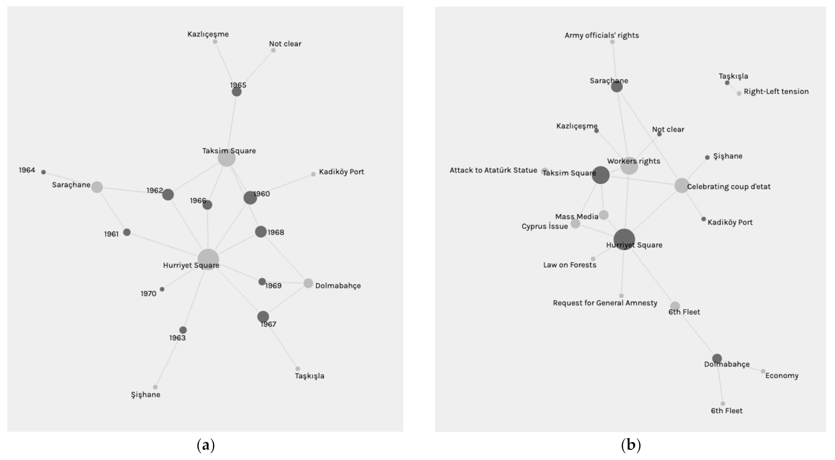
As mentioned in the methodology section, a rigorous archival research has been carried out using the digital newspaper archives (mainly the Cumhuriyet and Milliyet newspapers) in order to collect spatial information regarding the emerging protest movements throughout the 1960s. A visualization of the collected data immediately shows that the Hurriyet Square in the historic peninsula and the Taksim Square (a symbol also for the infamous Gezi Protests of 2013) have been protest spaces throughout the 1960s, whereas public spaces such as Saraçhane were famous in the early 1960s and gradually lost their popularity as protest spaces toward the late 1960s. On the contrary, Dolmabahçe became one of the most commonly used protest space in the late 1960s, whereas it was not used at all in the early 1960s (Figure 3a). Even though it is possible to arrive to a conclusion regarding the yearly change of the location of protests, it is not possible to argue that the selection of the locations was related to the main theme of the protests. For instance, the Hurriyet Square hosted both protests against a new law on forests, in 1967, and one of the major workers reunion in 1966. Similarly, Taksim Square hosted both protesters that defended Turkey in the infamous Cyprus issue and students and workers who defended their rights to strike (Figure 3b).
Among the spaces of the 1960s social movements, in the early 1960s, Saraçhane was the most popular place for worker manifestations. The most visible instance of this popularity was the protest on 31 December 1960. Approximately 150,000 people came together on this day. This meeting was one of the most important demonstrators of the accumulation of a working class movement throughout the 1950s. The new constitution was not even promulgated on this date (it would be promulgated in 1961), but the workers self-organized the largest meeting until then and demanded their social and political rights—and, most importantly, their right to strike [30].
Similar to Sarachane, Hurriyet (Freedom) Square, also known as Beyazit Square, is another important space for social movements. Hurriyet Square—which was constructed in the seventeenth century over Theodisus’s Forum, or the Forum Tauri, which was the largest forum in Constantinople, constructed in the fourth century CE—has been an important urban space ever since its formation in the Byzantine era.
The entrance to the Istanbul University is also located in Hurriyet Square, with a monumental nineteenth-century entrance door constructed in the Ottoman neo-classical style. Due to the existence of the university, this square has always been the main stage for the student movements. One of the major protests took place on 28 April 1960. The impact of this protest and the killing of a student protester (whose name was Turan Emeksiz) by the police prompted other students in other cities to get organized and stage manifestations. The main motivation of this protest were the government’s autocratic actions. In fact, within a few months, this government, the Democrat Party, would be overthrown by the army with a coup d’etat.
The Taksim Square, which was also the main protest space during the 2013 Gezi Resistance (a protest movement that started by opposing the conversion of one of the most important public parks of Istanbul into a shopping mall and steadily became a nation-wide movement, especially through social media [31]), has a historic significance in terms of public protests. However, it should also be noted that the major protest at the Taksim Square took place not in the 1960s but in the 1970s. It became an urban memory space for the workers’ movement in Turkey because on 1 May 1977, a huge assembly of political fractions met in Taksim Square to celebrate the Workers’ Day. However, a mass shooting by unknown forces created a massacre. Since then, 1 May 1977 is referred to as Bloody May 1st [32]. Taşkışla, which hosted the Istanbul Technical University’s Architecture Faculty was also another important space of student movements due to its proximity to Taksim Square.
In terms of the anti-Americanism of the 1960s, Dolmabahce Palace has an historical importance. In fact, Ataturk (the founder of the Turkish Republic following the collapse of the Ottoman Empire) had also spent his last days there. Thus, “In ’60s part of protesters, mainly right- wing student organizations had a tradition to come Dolmabahçe and pledge their commitment to the Republic in the presence of Ata” [33]. The largest protest took place when the US Sixth Fleet paid a visit to Istanbul, anchoring near the Dolmabahçe Mosque. The anti-war, pro-Vietnam tendencies and, in general, the global atmosphere of the 1968 generation, had already influenced the Turkish students. When the US soldiers disembarked from the Sixth Fleet, students blocked their access to Taksim Square. The closeness of the Istanbul Technical University also helped students outnumber the American soldiers. Students from the campus occasionally threw stones to the hotels of the American soldiers. This was a turning point for the 1960s’ student movements, because after this protest, the following manifestations would become more radicalized throughout the 1970s [34].
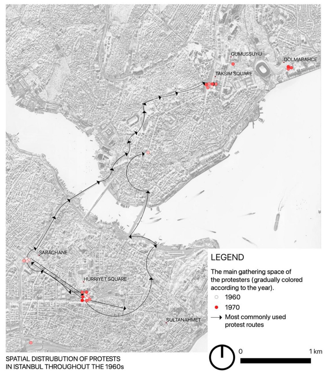
A spatial distribution of these protests and the most common marching routes are presented in Figure 4. It should be highlighted that these urban protests mostly included marching. One of the most famous routes of the march was the route that connected Hurriyet Square, in the historic peninsula, to Taksim Square, in the Beyoğlu district, outside the peninsula. It is also noteworthy that this route, the section from Hurriyet Square to the Topkapı Palace, was the main Imperial axis in the Ottoman period, called Divanyolu. Divanyolu corresponded to the Mese of Byzantine Constantinople, and it was the stage for the sultan’s stately procession. According to Cerasi, the Divanyolu or the Mese is “an aggregation of Byzantine spolia and new, fully Ottoman, spaces and concepts” [35]. This palimpsest quality of the historic peninsula of İstanbul has gained a new value in the 1960s, being the main protest axis of the spatial practices of society.
In all these spaces, to understand the historical continuum in terms of some patterns in the manifestation of social movements, it is necessary to look at the 1950s, because the urban operations of the 1950s unconsciously contributed to the urban condition of this acceleration of the social movements throughout the 1960s. Indeed, the 1961 constitution, as will be elaborated in the discussion section, also had an important role in this acceleration, but the infrastructure and social context was created in the 1950s. Although the 1950s’ government had repressed the opposition and blocked the rise of a social movement, the political developments and urban transformations of the 1950s had prepared the background for 1960s’ social movements.
The 1950s under the Democrat Party: Emergence of the Social and Urban Context of the Protest Movements of the 1960s
The Democrat Party (DP) ruled Turkey throughout the 1950s, gradually concentrating more power and using it against the opposition, especially in the late 1950s. In fact, the protest on 28 April 1960 was also organized against this autocratic regime. Only one month after this protest, on 27 May 1960, the army staged a coup and terminated the government. In 1956, the DP launched an immense urban project called İmar Hareketi, or İstanbul’un İmarı (which means the Development Movement, or Istanbul’s Development). Regarding the impact of the Imar project on the historic urban environments, one of the most important source is an article published in 1969 [36] and an anonymous 1957 publication by the Istanbul Municipality (-, 1957) called İstanbul’un Kitabı (the Book of Istanbul) [37]. A visualization of this impact in the historic peninsula is presented in Figure 5.
This project was launched one year before the parliamentary elections. After the launch of the project, the whole city became a construction site in less than a year. The main criticism was centered around the pace of construction, the wide extent of expropriations, and the lack of a master plan [38,39]. During the implementation of the project, the General Directorate of Highways (KGM—Karayolları Genel Müdürlüğü) was one of the most influential decision-making actors. KGM was established in 1950 under the Ministry of Public Works as a part of the Marshall Plan, and it was mainly needed for the distribution of agricultural products. Moreover, a new road network was needed more than ever, since the American influence had a profound impact on the automotive sector. The decisions on the construction were mainly based on the decisions of the KGM. However, for the engineers, the city’s existing historic and topographic features needed to be “fixed” for the city to have a well-functioning road network. The KGM engineer Muzaffer Uluşahin’s remark “this city has a hunchback; we need to fix it” is still used to outline the planning approach of the 1950s. The approach of the KGM was to use the intra-cities highway construction standards in a historic urban setting without an adaptation process [40]. For the construction of Vatan and Millet Avenues, the section of the city walls that coincided with the new road was immediately demolished.
The pace of these deconstructions did not allow for any survey of the city land walls that remained between the buildings or on the courtyards of the building blocks. Moreover, on the Karaköy district, located on the other side of the Golden Horn, the new roads damaged historic structures. One of the most heated debates emerged during the widening of the Ordu Avenue, which is the avenue traversing Hurriyet Square. This was due to the destruction of several monumental seventeenth-century Ottoman buildings for widening Ordu Avenue. However, even after these developments, Hurriyet Square never lost importance as a protest space. An architectural competition was launched in the 1960s for the square. Even though the prominent Turkish architect Turgut Cansever’s winning project, which was designed with a modernist architectural language to geometrically reorganize the square, was not fully implemented and the square remained inefficiently used, it never lost its meaning as a historical protest space [33,41]
4. Discussion
In the discussion section, the results are discussed from different perspectives, namely: (i) the socio-political context, (ii) the legal framework, (iii) economic and ideological aspects, and (iv) spatial aspects. It should be immediately said that the spatial research has revealed the main finding of this article, which is that despite the political, economic, ideological, societal, and cultural differences between the 1950s and the 1960s, the urban space shows the historical continuum between the two decades. This finding was possible by using digital tools, and this importance is also discussed in a separate subsection (v). Lastly, the relationship between sustainability and critical heritage research is also discussed (vi), both highlighting the central role of heritage in the state of the art of sustainability discussions and discussing how this role can be enhanced and reinforced through digital tools and critical perspectives.
4.1. Discussion of the Socio-Political Context
As mentioned in the methodology section, the selection of the 1960s as the main temporal research focus is significant for the scope of the research because it was the decade in which social movements accelerated, in line with the socio-political context of the period. However, in order to understand the underlying reasons of this acceleration, it is necessary to identify what happened in the 1950s.
After the foundation of the Republic in 1923, a single-party regime had ruled the country with an immensely centralized power until the 1950 election, after which, for the first time, a new political party, the DP, challenged the Republican rulers and won the elections. Afterwards, they either reversed or slowed down some of the reforms. The DP’s electoral victory was related to the frustration of society after the quarter-century-long single-party rule (Republican People’s Party—CHP) of the republican regime [42]. The promising new government was successful, especially in the economic development, in the first half, but toward the late 1950s it struggled in three main areas. The first of these was economics, despite the fact that a financial restructuring helped the country to recover from the war. The private sector was encouraged, and agricultural and industrial production increased. Moreover, literacy increased. In terms of the physical environment, the urban character of villages, towns, and cities physically changed with widened roads, new arteries, and demolished buildings [38]. This sudden economic growth threatened the overall economic policies, leading to debts and eventually placing the government in economic hardship. The second problem was related to political freedom. The DP had made efforts to repress the press, universities, and intellectuals who opposed DP policies. Moreover, CHP’s assets and properties were transferred to the Treasury, and the political activities of new parties were restricted. The third problem was about religion. The DP was accused of reversing many secular reforms. For instance, religion courses were re-included in the curriculum, and unless parents asked for an exemption, all Muslim students were required to follow the course. Islamic education schools, imam-hatip schools, were also established in this era. Religious leaders appeared in public and preached against secularism. There was an interest in restoring the dervish orders. Even though a generation was already raised under republican reforms, Islam was still a uniting force in society. As will be discussed further below, this interest in Islam would be seen in conservation projects as well [42,43,44]. For some scholars, DP government’s time was an era in which an Islam-oriented rhetoric dominated the political atmosphere along with nationalism. The construction activities are generally considered as an echo of a populist nationalist Islamic discourse over architecture and urban planning [39,41,45]
The 1960s in Turkey started with the resetting of the whole country with a coup d’état. Following this intervention of the army in the governance of the country, in 1960, officials of the fallen government were put in jail, and some were even sentenced to death, including the Prime Minister Adnan Menderes. In fact, as will be explained below, it is seen from the newspapers that in the early 1960s, the reason for gathering was either celebrating this coup or protesting against the members of the fallen governments. Even years after the coup d’etat, on 26 March 1963, when the army freed the ex-president Celal Bayar because of his considerable age, ten thousand students came together in Hurriyet (Freedom) Square, walking towards Şişhane to request the continuation of Bayar’s arrest [46]. Following the coup, a new constitution was designed under the management of the army by a group of intellectual elite men that included university professors. The main idea was to prevent the emergence of an autocratic government like the DP (the fallen government of the 1950s) and to give the power back to society through general elections. However, it is also argued that this coup and the following constitution was an attempt of an elite community to regain the power that was taken from them throughout the 1950s [47]. As the 1961 constitution introduced measures to prevent the re-emergence of an authoritarian centralized government through various control mechanisms, it also generated a social atmosphere in which diverse political ideas could flourish, especially on the left. Socialist parties were represented in the parliament. However, due to rising political tensions, in order to preserve the status quo that was threatened by the increasing leftist movement, the army made a second intervention in 1970, forcing the government to resign. The best word to describe the decade after the 1971 intervention is “chaos”. Fragmented and polarized political movements confronted each other. Extremist militants also emerged in this era of conflicts, in which waves of violence gradually escalated. By the late 1970s, the parliament could not even select a president [48].
4.2. Discussion of the Legal Framework
The 1961 constitution was a product of the politician–intelligentsia collaboration. In a way, the new constitution re-emphasized the power of an upper class that was threatened by the peasant class who migrated to cities throughout the 1950s [47]. Those who immigrated from rural areas to cities formed a working-class movement which gained momentum throughout the 1960s. In fact, even in the 1950s, there was already a small political group among the workers of Turkey. Under the new constitution, this group was now given a liberated space to accelerate their political activities. As several worker unions were formed in the early 1960s (such as Türk-İş Union, founded with the advice of the American Federation of Labour–Congress of Industry Organizations), in the second half of the same decade, some fractions emerged out of these unions (such as DİSK—Devrimci İşçi Sendikaları Konfederasyonu/ the Confederation of Revolutionary Workers’ Unions). According to their positioning against the government, these fractions started to fight each other (for instance, Türk-İş became a pro-government union, whereas DİSK attracted left-wing sympathizers). Moreover, the socialist intellectuals had established the Turkey Workers Party (TİP—Türkiye İşçi Partisi) in 1961 to prompt a political movement uniting workers and intellectuals. In the next elections, TİP had won seats in the parliament [44].
The new constitution had formulated the state as a social state, which provided more liberties than ever; universities gained their autonomy, university students could protest, and workers could strike. Women’s movements were also active. In a way, in the changing atmosphere of the post-war world, Turkey was also re-defining its position. This position, in a bi-polar global power struggle, was in the capitalist pole. Nevertheless, Soviet power was still influential [42]. In this era, also in the heritage field, there were significant improvements in terms of upholding post-war European standards. Even in the constitution, a specific article made reference to the importance of the protection of cultural heritage. indicating that “the state ensures the protection of all the monuments with historic or cultural value” [49]. In addition, the 1964 Venice Charter was embraced as a guiding text and capacity-building activities were undertaken, such as sending Turkish officials to the various trainings organized by international preservation organizations. However, this development was also managed by a limited elite expert community. In a way, in the 1960s, in the architecture and heritage field, experts re-gained the power that was lost throughout the 1950s [50,51].
4.3. Discussion of the Economic Aspects and Anti Communism Propaganda
One of the major developments that had an impact on the development of the country was the establishment of the State Planning Organization (DPT—Devlet Planlama Teşkilatı) in 1960. DPT managed the economic structure of the new state by generating financial policies through Five-Year Development Plans. Structures similar to DPT were already active in Europe. However, in Europe, many states’ resources had already increased following a certain period of capitalist development. In Turkey, on the other hand, this process of development had not yet been reached. Nevertheless, DPT was devised to help Turkey recover from economic hardship [44]. The First Plan was for 1963–1967. It included a series of reforms to restructure the central administration. Urban issues were also addressed in this plan, such as the definition of various planning schemes. The Second Plan was for 1968–1972. It was prepared to meet market demands. Modernization in agriculture, urbanization, and industrialization were formulated as integral goals, and urbanization was once more projected to provide a major income for the state budget. In addition, the need for social housing was highlighted in this plan [52]. The third plan came in a completely different political context; the military had once more intervened with an ultimatum.
As one can see, parallel to the societal changes, the 1960s were an era in which Turkey became politicized and a left tradition emerged from the liberal milieu produced by the new constitution. The students in the universities were following Marxist literature even in small towns. Even in this period, the US was still an ally to Turkey. The government was still committed to US policies. Strangely, Turkey’s emerging left and the conservatives were both on the same page in criticizing the government’s loyalty to the US. Ironically, both the left and the right wing became anti-American. International developments also had influence on Turkey’s leftists; the May events in France encouraged them to be more involved and active in politics. The conservatives, on the other hand, established organizations such as the Association to Fight Communism as early as 1962. This was a global trend; the Union of the World of Islam was also established with a similar agenda, to fight against communism. In fact, one of the themes repeated in the protests of the 1960s was “condemning communism (komunizmi tel’in)” [53]. These meetings had already started in the early periods of the fallen DP government in the 1950s to underline “the danger of communism” [53]. Anti-communism was one of the main themes that emerged in the 1950s and survived the coup d’état dominating the political atmosphere of the 1960s and 1970s [54]. The rising workers movement disturbed capital owners, who argued that, in Turkey’s development process, it was too early for workers to gain the right to strike or to collective bargaining. The ultimatum of the army to the government in 1971 brought this early luxury for Turkey’s working class to an end. The military intervention responded to the request of the business/industry community [55].
4.4. Discussion of the Spatial Aspects
In the 1960s, society was changing and forming a strong working-class movement, but the spatial context of this change was inherited from the previous government, which was superseded by the army throughout the 1950s. These relations shows the complex dynamics of society, but these dynamics reveal themselves through space, and especially through urban space.
In the late 1950s, the DP launched the Development of the Istanbul project, which transformed the whole city into a construction site. The projects were mainly about road constructions, and any structure that obstructed this process was demolished or removed without hesitation. However, a coup d’etat put all the government officials in prison and eventually executed the prime minister. In the current literature, the 1960 coup is referred to as the termination of the DP era and the passage to a new era. The two decades are generally separated as different contexts. However, there is also a continuity, which is outlined in this paper. This historical continuity is embedded in the urban space, social movements, and social mobility patterns. In order to understand and visualize this spatial continuity between the two decades, mainly GIS is used for the spatialization of both the urban change that came in the 1950s and the spaces of social movements of the 1960s. This spatial analysis showed that despite the above-mentioned differences between the two decades, the developments in the 1950s had in fact prepared both the spatial and the social basis of the social movements of the 1960s.
4.5. Discussion of the Use of Digital Tools for Urban History and Urban Heritage
Using digital tools and adapting the methodologies of the digital humanities create an intersection of specific disciplinary practices with computation. For instance, in history, the digital age completely transformed the discipline, bringing together historians and technology [56]. This intersection offers new critical perspectives for researching the relationship between space and societal urban dynamics. In addition, mapping the technologies available today provides even better understandings and insights into human behavior in urbanized landscapes. In fact, spatial analysis has always been at the core of critical theory, and through digital tools, especially via Geographic Information Systems (GIS), new interdisciplinary methods (such as Historical GIS or Literary GIS) allow researchers from all disciplines to undertake research on space and reveal the critical potential of spatial research in investigating complex social dynamics [57]. In recent years, using digital tools to understand space has been a method adopted by many scholars and activists to develop a critical perspective to question the relationship between space and power [58]. Some scholars even provide a step-by-step manual to inspire further research for the use of digital tools to examine the power dynamics and challenge the status quo [59]. However, it should be also mentioned that digital methods are not tools to generate absolute facts and/or universalizing social-historical explanations, since there can always be other explanations.
Within this context, also in this article, digital tools have been utilized with a dual motive. Firstly, they allowed for the evaluation of the relationship between society and urban heritage. Through a georeferenced investigation of urban movements and urban projects, it is seen that two different periods were strongly interlinked despite the differences in the socio-political context, legal framework, economic aspects, and ideological background. Although urban movements flourished in a period during which an autocratic government was overthrown, it was, in fact, the urban operations of the very same autocratic government that enabled urban movements. This evidences the complexities related to the different performative power of urban heritage depending on the period. Secondly, it has also given visibility to a part of urban history that is usually not represented in the urban narrations on Istanbul or in the images that represent Istanbul. Using digital collections, creating data sheets to organize information, analyzing and visualizing the data, this research renders the 1960s’ urban movements more visible and represents them in a map which is, per se, a representation of space.
4.6. Discussion of Sustainability
In the UN Sustainable Development Goals, a specific reference to cultural heritage is made in Goal 11, Target 4. However, there is a strong cultural dimension in all of the SDG goals, and heritage has an indispensable role in this perspective [60]. As highlighted in the European Cultural Heritage Green Paper (which is the report prepared by ICOMOS, Europa Nostra, and the European Investment Bank), this role also encompasses the main premises of the European Green Deal [61]. In addition, the New European Bauhaus also underlines the necessity to “revisit Europe’s cultural heritage and shape its future” [62]. As more than half of the world’s population is living in cities, urban life and urbanized landscapes are central to the discussion on sustainable development. For this reason, there is an urgent need to enhance our understanding of how heritage operates within a society. As discussed in this paper, we can gain this knowledge by utilizing the methodologies of digital humanities to analyze, understand, and present the heritage dynamics, especially in urban settings. In addition, it should be highlighted that for achieving social and cultural sustainability, intangible values must be considered in addition to the tangible values [60,63]. For the case of Istanbul, this paper also contributes to social and cultural sustainability because, by researching the societal use of the historic urban areas of Istanbul in the 1960s, and representing this use through maps, it sheds light on the intangible values of these urban spaces.
5. Conclusions
Based on the points made in the results and discussions, the main conclusion is that for revealing the full potential of cultural heritage in sustainable development, it is necessary to deepen our knowledge of how heritage operates within a society. A critical and conscious use of digital tools and digital humanities methodologies can help define this role. To do this, the question “Who defines cultural heritage for whom, with what purposes, when, and in which context?” is vitally important. In the last decades, scholars have already underlined that cultural heritage is present-centered and, for this reason, it has political underpinnings. Therefore, to have a deeper understanding of cultural heritage, it should be considered that heritage changes meaning depending on the socio-political context of the period.
Funding
This research received no external funding.
Conflicts of Interest
The author declares no conflict of interest.
References
- United Nations. Sustainable Development; Goals. Available online: https://sdgs.un.org/goals/goal11 (accessed on 10 May 2021).
- Council of Europe. Council Approves Conclusions Recognising the Key Role of Cultural Heritage in Promoting Peace, Democracy and Sustainable Development. 21 June 2021. Available online: https://www.consilium.europa.eu/en/press/press-releases/2021/06/21/council-approves-conclusions-recognising-the-key-role-of-cultural-heritage-in-promoting-peace-democracy-and-sustainable-development/ (accessed on 23 June 2021).
- EU, Directorate-General for Education. European Framework for Action on Cultural Heritage; Publications Office of the European Union: Luxembourg, 2019. [Google Scholar]
- Bandarin, F. Urban Conservation and Sustainable Development. Hist. Environ. Policy Pract. 2020, 11, 444–453. [Google Scholar] [CrossRef]
- Lowenthal, D. The Past Is a Foreign Country; Cambridge University Press: Cambridge, UK, 1985. [Google Scholar]
- Gentry, K.; Smith, L. Critical Heritage Studies and the Legacies of the Late-Twentieth Century Heritage Canon. Int. J. Herit. Stud. 2019, 25, 1148–1168. [Google Scholar] [CrossRef]
- Silverman, H. Contested cultural heritage: A selective historiography. In Contested Cultural Heritage; Springer: New York, NY, USA, 2011; pp. 1–49. [Google Scholar]
- Graham, B.J.; Howard, P. The Ashgate Research Companion to Heritage and Identity; Ashgate Publishing, Ltd.: Hamphshire, UK, 2008. [Google Scholar]
- Smith, L. Uses of Heritage; Routledge: New York, NY, USA, 2006. [Google Scholar]
- Haldrup, M.; Bœrenholdt, J.O. Heritage as Performance. In The Palgrave Handbook of Contemporary Heritage Research; Waterton, E., Watson, S., Eds.; Palgrave Macmillan UK: London, UK, 2015; pp. 52–68. [Google Scholar]
- Harrison, R. (Ed.) Heritage Futures: Comparative Approaches to Natural and Cultural Heritage Practices; UCL Press: London, UK, 2020. [Google Scholar]
- Ashworth, G.J.; Graham, B.; Tunbridge, J.E. Pluralising Pasts: Heritage, Identity and Place in Multicultural Societies; Pluto Press UK: London, UK, 2007. [Google Scholar]
- Taylor, P. Urbanization. In The Oxford Handbook of Global Studies; Oxford University Press: New York, NY, USA, 2018. [Google Scholar]
- Pasotti, E. Resisting Redevelopment: Protest in Aspiring Global Cities; Cambridge Studies in Contentious Politics; Cambridge University Press: Cambridge, UK, 2020. [Google Scholar]
- Clinton, C.K.; Jackson, F.L.C. Historical Overview, Current Research, and Emerging Bioethical Guidelines in Researching the New York African Burial Ground. Am. J. Phys. Anthropol. 2021, 175, 339–349. [Google Scholar] [CrossRef] [PubMed]
- Bilsel, C. The Crisis in Conservation: Istanbul’s Gezi Park between Restoration and Resistance. J. Soc. Archit. Hist. 2017, 76, 141–145. [Google Scholar] [CrossRef]
- Rabbat, N. The Arab Revolution Takes Back the Public Space. Crit. Inq. 2012, 39, 198–208. [Google Scholar] [CrossRef]
- Carruthers, W. Heritage, Preservation, and Decolonization: Entanglements, Consequences, Action? Future Anterior J. Hist. Preserv. Hist. Theory Crit. 2019, 16, iii–xxiv. [Google Scholar] [CrossRef]
- Castells, M. The Urban Question: A Marxist Approach; MIT Press: Cambridge, MA, USA, 1977. [Google Scholar]
- Castells, M. The City and the Grassroots: A Cross-Cultural Theory of Urban Social Movements; University of California Press: Berkeley, CA, USA, 1983. [Google Scholar]
- Harvey, D. Rebel Cities: From the Right to the City to the Urban Revolution; Verso Books: London, UK, 2012. [Google Scholar]
- Yip, N.M.; Martínez López, M.A.; Sun, X. (Eds.) Contested Cities and Urban Activism; Springer: Singapore, 2019. [Google Scholar]
- Miller, B.; Nicholls, W. Social Movements in Urban Society: The City as A Space of Politicization. Urban Geogr. 2013, 34, 452–473. [Google Scholar] [CrossRef] [Green Version]
- Byrne, D. Countermapping. In The Encyclopedia of Archaeological Sciences; López Varela, S.L., Ed.; John Wiley & Sons, Inc.: Hoboken, NJ, USA, 2018; pp. 1–4. [Google Scholar]
- Vaughan, L. Mapping Society: The Spatial Dimensions of Social Cartography; UCL Press: London, UK, 2018. [Google Scholar]
- Pickles, J. A History of Spaces: Cartographic Reason, Mapping and the Geo-Coded World; Routledge: London, UK, 2003. [Google Scholar]
- Crampton, J.W.; Krygier, J. An Introduction to Critical Cartography. ACME Int. J. Crit. Geogr. 2005, 4, 11–33. [Google Scholar]
- Masterson, V.A.; Enqvist, J.P.; Stedman, R.C.; Tengö, M. Sense of Place in Social–Ecological Systems: From Theory to Empirics. Sustain. Sci. 2019, 14, 555–564. [Google Scholar] [CrossRef] [Green Version]
- Harrison, R. ‘Counter-mapping’ heritage, communities and places in Australia and the UK. In Local Heritage, Global Context: Cultural Perspectives on Sense of Place; Schofield, J., Szymanski, R., Eds.; Ashgate: Farnham, UK, 2011; pp. 79–98. [Google Scholar]
- Koçak, M.H.; Çelik, A. Türkiye İşçi Sınıfının Ayağa Kalktığı Gün: Saraçhane Mitingi. Calisma Toplum 2016, 49, 647–678. [Google Scholar]
- Haciyakupoglu, G.; Zhang, W. Social Media and Trust during the Gezi Protests in Turkey. J. Comput. Mediat. Commun. 2015, 20, 450–466. [Google Scholar] [CrossRef] [Green Version]
- Baykan, A.; Hatuka, T. Politics and Culture in the Making of Public Space: Taksim Square, 1 May 1977, Istanbul. Plan. Perspect. 2010, 25, 49–68. [Google Scholar] [CrossRef]
- Fidan, G. History of Protest Spaces in İstanbul; Kadir Has University: İstanbul, Turkey, 2019. [Google Scholar]
- Alper, E. Protest Diffusion and Rising Political Violence in the Turkish’68 Movement: The Arab-Israeli War,“Paris May” and The Hot Summer of 1968. In Dynamics of Political Violence: A Process-Oriented Perspective on Radicalization and the Escalation of Political Conflict; Bosi, L., Demetriou, C., Malthaner, S., Eds.; Ashgate: Burlington, CA, USA, 2016; pp. 255–275. [Google Scholar]
- Cerasi, M. The Urban and Architectural Evolution of the Istanbul Divanyolu: Urban Aesthetics and Ideology in Ottoman Town Building. Muqarnas Online 2005, 22, 189–232. [Google Scholar]
- Ünsal, B. Istanbul’un Imarı ve Eski Eser Kaybı. Türk Sanatı Tar. Araştırma İncelemeleri 1969, 2, 41–61. [Google Scholar]
- İstanbul Vilayeti Neşriyat ve Turizm Müdürlüğü. İstanbul’un Kitabı; İstanbul Vilayeti Neşriyat ve Turizm Müdürlüğü: İstanbul, Turkey, 1957. [Google Scholar]
- Gül, M. Emergence of Modern Istanbul: Transformation and Modernisation of a City; IB Tauris: New York, NY, USA, 2009. [Google Scholar]
- Akpınar, İ. The Rebuilding of Istanbul: The Role of Foreign Experts in the Urban Modernisation in the Early Republican Years. New Perspect. Turk. 2014, 50, 59–92. [Google Scholar] [CrossRef]
- Tekeli, İ. Cumhuriyetin Belediyecilik Öyküsü, 1923–1990; Tarih Vakfı Yurt Yayınları: İstanbul, Turkey, 2009. [Google Scholar]
- Kuban, D. Menderes ve İstanbul. Dünden Bugüne İstanbul Ansiklopedisi 1994, 389, 392. [Google Scholar]
- Zürcher, E.J. Turkey: A Modern History; Bloomsbury Publishing: New York, NY, USA, 2017. [Google Scholar]
- Shaw, S.J.; Shaw, E.K. History of the Ottoman Empire and Modern Turkey: Volume 2, Reform, Revolution, and Republic: The Rise of Modern Turkey 1808–1975; Cambridge University Press: Cambridge, UK, 1977; Volume 11. [Google Scholar]
- Ahmad, F. The Making of Modern Turkey; Routledge: New York, NY, USA, 2002. [Google Scholar]
- Altınyıldız, N. Tarihsel Çevreyi Korumanın Türkiye’ye Özgü Koşulları (İstanbul 1923–1973). Ph.D. Thesis, İstanbul Teknik Üniversitesi, İstanbul, Turkey, 1997. [Google Scholar]
- Bayar’ın Tahliyesini Protesto Için 10,000 Üniversiteli Bir Yürüyüş Yaptı. Cumhuriyet Newspaper, 26 March 1963; p. 1.
- Keyder, Ç. State and Class in Turkey: A Study in Capitalist Development; Verso: London, UK, 1987. [Google Scholar]
- Gourisse, B. In the Name of the State. The Nationalist Action Party (MHP) and the Genesis of Political Violence during the 1970s. Turk. Stud. 2021, 1–21. [Google Scholar] [CrossRef]
- Mumcu, A. Eski Eserler Hukuku ve Türkiye. Ank. Üniversitesi Hukuk Fakültesi Derg. 1971, 28, 41–76. [Google Scholar] [CrossRef]
- Dinler, M. A Political Framework for Understanding Heritage Dynamics in Turkey (1950–1980). Urban Hist. 2021, 1–19, firstview. [Google Scholar] [CrossRef]
- Dinler, M. Formulation of Historic Residential Architecture as a Background to Urban Conservation. J. Cult. Herit. Manag. Sustain. Dev. 2020, 11, 1–17. [Google Scholar] [CrossRef]
- Madran, E.; Ozgonul, N. Planlı Dönemde (1963–1981) Tarihsel Çevrenin Korunması ve Değerlendirilmesinde Kamunun Yaklaşımı. Türkiye Birinci Şehircilik Kongr. 1984, 2, 283–294. [Google Scholar]
- Elmacı, M.E.; Sarı, İ. Demokrat Parti’nin İlk Döneminde Sol Algisina Bir Örnek; Komunizmi Tel’in Hareketleri (1950–1954). J. Hist. Sch. 2019, XLI, 664–714. [Google Scholar] [CrossRef]
- Landau, J.M. Radical Politics in Modern Turkey; Routledge: London, UK, 2016. [Google Scholar]
- Christofis, N. Coups and State Formation in Turkey. In The Routledge Handbook on Contemporary Turkey; Routledge: Oxon, UK, 2021. [Google Scholar]
- Crymble, A. Technology and the Historian: Transformations in the Digital Age; University of Illinois Press: Champaign, IL, USA, 2021. [Google Scholar]
- Dunn, S. A History of Place in the Digital Age; Routledge: Oxon, UK, 2020. [Google Scholar]
- Losh, E.; Wernimont, J. Bodies of Information: Intersectional Feminism and the Digital Humanities; U of Minnesota Press: Minneapolis, MN, USA, 2019. [Google Scholar]
- D’Ignazio, C.; Klein, L.F. Data Feminism; MIT Press: Cambridge, MA, USA, 2020. [Google Scholar]
- Labadi, S.; Giliberto, F.; Rosetti, I.; Shetabi, L.; Yildirim, E. Heritage and the Sustainable Development Goals: Policy Guidance for Heritage and Development Actors; ICOMOS: Paris, France, 2021. [Google Scholar]
- Potts, A. European Cultural Heritage Green Paper; Europa Nostra: The Hague, The Netherlands; Brussels, Belgium, 2021. [Google Scholar]
- European Union. New European Bauhaus. 2021. Available online: https://europa.eu/new-european-bauhaus/about/about-initiative_en (accessed on 27 June 2021).
- Ginzarly, M.; Houbart, C.; Teller, J. The Historic Urban Landscape Approach to Urban Management: A Systematic Review. Int. J. Herit. Stud. 2019, 25, 999–1019. [Google Scholar] [CrossRef]
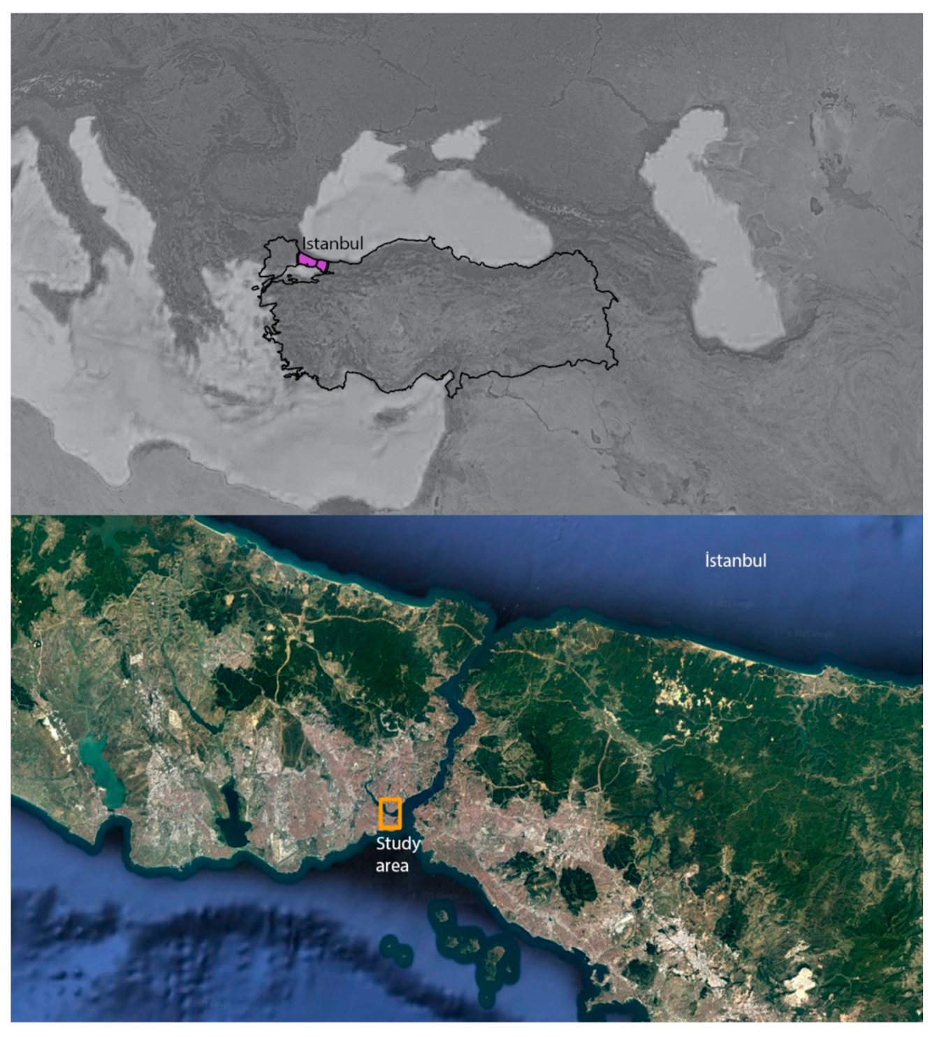
Figure 1.
Map showing İstanbul in Turkey, and the study area in İstanbul.

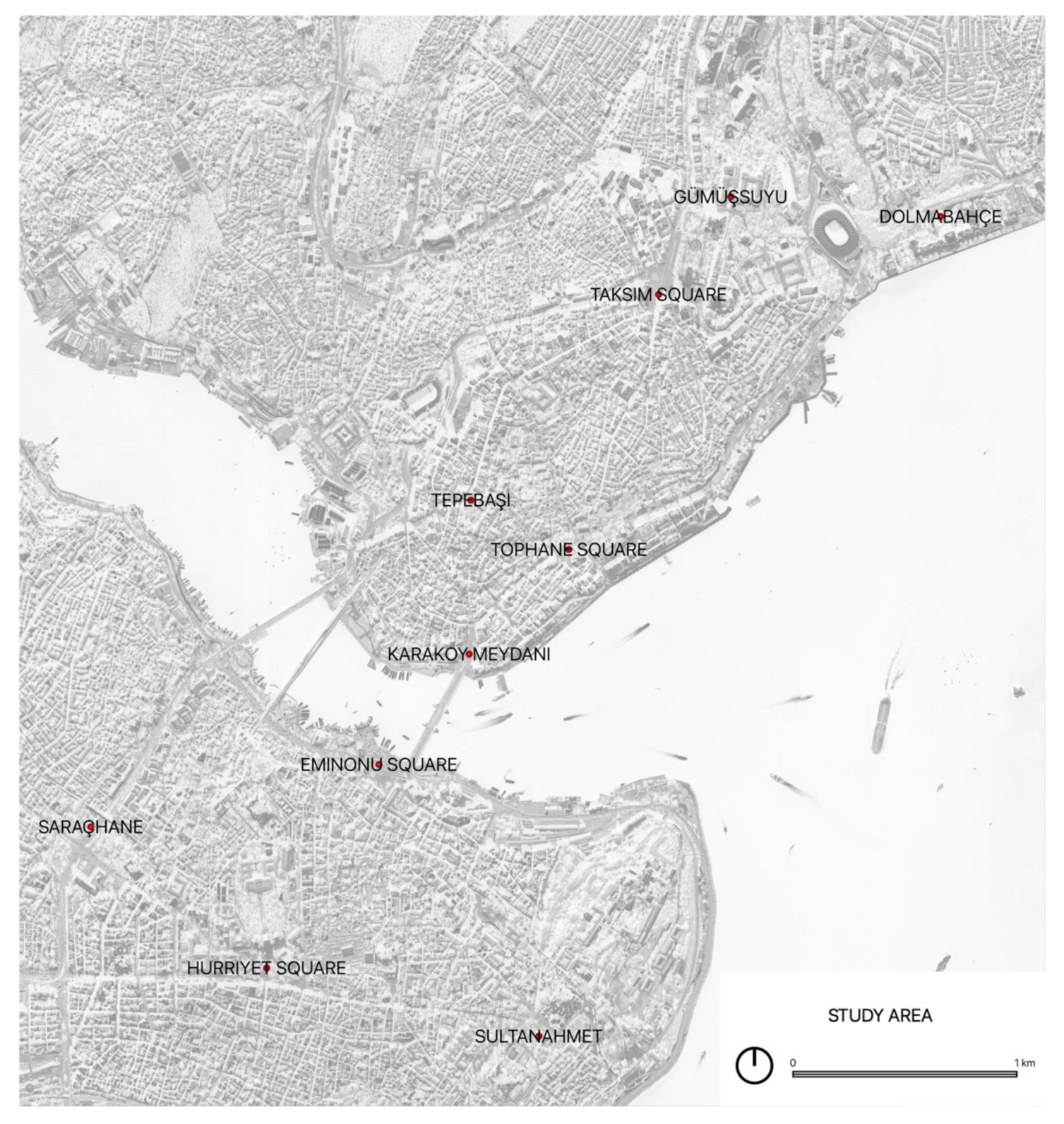
Figure 2.
Study Area.

Figure 3.
A visual analysis of the collected data through the online Palladio platform. The collected information was organized through attributes and then converted into a comma-separated values (CSV) file for the purpose of data visualization and analysis. (a) shows the use of urban spaces based on years. The dimension of the circle indicating the urban space depends on the frequent use of the space by protesters. As can be seen, Hurriyet and Taksim Squares were the popular spaces throughout the 1960s. The dimension of the circle indicating the year depends on the number of protests. It can be seen that there were less protests in 1961 and 1964. (b) shows the general theme of the protests with their relation to the main urban gathering spaces. The dimension of the circle indicating the urban space depends on the frequent use of the space by protesters. The dimension of the circle indicating the theme depends on the number of protests organized for the same theme. It can be seen that some recurring themes were workers’ rights, the Cyprus issue, the 6th Fleet, etc. As mentioned above, it is not possible to suggest a direct relation between the theme of the protest and the selection of the location.

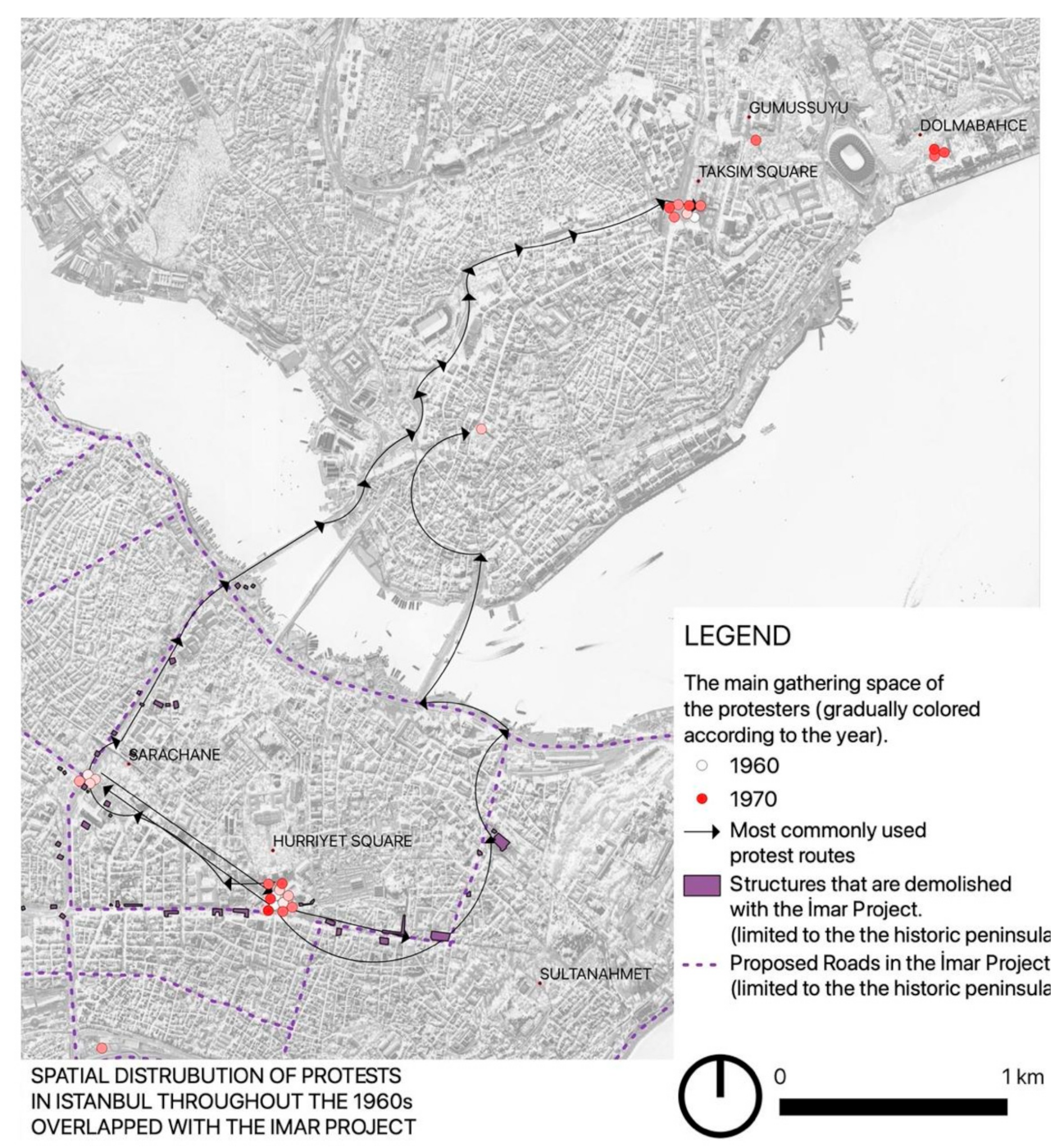
Figure 4.
Spatial Distribution of Protests in Istanbul throughout the 1960s. The map was produced by the author on QGIS by geo-refencing the collected information. As can be noticed, the events are given a color code based on the date information on their attributes. Accordingly, it can be noticed that Saraçhane was frequently used in the early 1960s (light-colored points), whereas Taksim Square was frequently used in the late 1960s (dark-colored points). Hurriyet Square, which is also known as Beyazıt Square, was always a common gathering space in the given period. In addition, whenever the information is available, the route of the protesters’ march is also included in the attributes. This information is also visualized in the map. As can be seen, Hurriyet Square was the main departure point before the start of the marches.

Figure 5.
Juxtaposition of the 1960s’ protest spaces (presented in the Figure 4) with the construction works implemented during Istanbul’s Redevelopment Project. Created by the author.
Figure 5.
Juxtaposition of the 1960s’ protest spaces (presented in the Figure 4) with the construction works implemented during Istanbul’s Redevelopment Project. Created by the author.


Table 1.
Attributes defined in QGIS, according to which information on protests is organized.
| Attributes | Definition of Attributes |
|---|---|
| Date | The exact date of the protest. |
| Duration | The duration of the protest if it lasted more than a day. |
| Start | Indicates the initial location of the protest if the protesters were mobile. |
| Finish | Indicates the final location of the protest if the protesters were mobile. |
| Route | The route that protesters followed from Start to Finish. |
| Main Gathering Space | The main gathering space of the protesters. |
| Main Group | The main social group (students, workers, women, civil servants, etc.) that participated in the protest. |
| Number | The approximate number of the crowd (if indicated). |
| Main Organizing Group | The main political fraction/group/student clubs that had a major role in the organizing the protest. |
| Participating Groups | Other political fraction/group/student clubs that participated. |
| Resource (Archive) | The newspaper that published the news. |
| Search Keyword | The keywords used for searching on the archive of the resource (the newspaper). |
| Main Theme | The main theme of the protest indicated with keywords. |
| Description | A more detailed description of the reason of the protest. |
| Comments | Comments to consider. |
| Reference | Scholarly references particularly related to the indicated protest. |
| Photo/Video/Audio | File names of any audiovisual materials related to the indicated protest. |
Publisher’s Note: MDPI stays neutral with regard to jurisdictional claims in published maps and institutional affiliations. |
© 2021 by the author. Licensee MDPI, Basel, Switzerland. This article is an open access article distributed under the terms and conditions of the Creative Commons Attribution (CC BY) license (https://creativecommons.org/licenses/by/4.0/).
Share and Cite
MDPI and ACS Style
Dinler, M. Counter-Mapping through Digital Tools as an Approach to Urban History: Investigating the Spatial Condition of Activism. Sustainability 2021, 13, 8904. https://0-doi-org.brum.beds.ac.uk/10.3390/su13168904
AMA Style
Dinler M. Counter-Mapping through Digital Tools as an Approach to Urban History: Investigating the Spatial Condition of Activism. Sustainability. 2021; 13(16):8904. https://0-doi-org.brum.beds.ac.uk/10.3390/su13168904
Chicago/Turabian StyleDinler, Mesut. 2021. "Counter-Mapping through Digital Tools as an Approach to Urban History: Investigating the Spatial Condition of Activism" Sustainability 13, no. 16: 8904. https://0-doi-org.brum.beds.ac.uk/10.3390/su13168904
Note that from the first issue of 2016, this journal uses article numbers instead of page numbers. See further details here.