Article

Advances in Geoheritage Mapping: Application to Iconic Geomorphological Examples from the Italian Landscape

by
Paola Coratza
1,*,
Irene Maria Bollati
2,*,
Valeria Panizza
3,
Pierluigi Brandolini
4,
Doriano Castaldini
1,
Franco Cucchi
5,
Giacomo Deiana
6,
Maurizio Del Monte
7,
Francesco Faccini
4,
Furio Finocchiaro
5,
Dario Gioia
8,
Rita Melis
6,
Carmine Minopoli
9,
Olivia Nesci
10,
Guido Paliaga
11,
Micla Pennetta
12,
Luigi Perotti
13,
Alessia Pica
7,
Federico Tognetto
13,
Alfredo Trocciola
14,
Laura Valentini
15,
Marco Giardino
13 and
Manuela Pelfini
2
add Show full author list remove Hide full author list
1
Department of Chemical and Geological Sciences, University of Modena and Reggio Emilia, Via Campi, 103, 41125 Modena, Italy
2
Earth Sciences Department “Ardito Desio”, University of Milan, Via Mangiagalli, 34, 20133 Milano, Italy
3
Department of History, Human Sciences and Education, University of Sassari, Via Zanfarino, 62, 07100 Sassari, Italy
4
Department of Earth, Environmental and Life Sciences, University of Genoa, Corso Europa, 26, 16132 Genoa, Italy
5
Department of Mathematics and Geosciences, University of Trieste, Via E. Weiss, 2, 34128 Trieste, Italy
6
Department of Chemical and Geological Sciences, University of Cagliari, Cittadella Universitaria (Blocco A)-S.S. 554 bivio per Sestu, 09042 Monserrato, Italy
7
Earth Sciences Department, La Sapienza University of Rome, Piazzale Aldo Moro, 5, 00185 Rome, Italy
8
Institute of Heritage Sciences, National Research Council (ISPC-CNR), C.da S. Loja, 85050 Potenza, Italy
9
National Institute of Geophysics and Volcanology (INGV), Osservatorio Vesuviano, Via Diocleziano, 328, 80124 Napoli, Italy
10
Dipartimento di Scienze Pure ed Applicate, Università degli Studi di Urbino “Carlo Bo”, Via Cà Le Suore, 61029 Urbino, Italy
11
Research Institute for the Geo-Hydrological Protection, National Research Council, Strada delle Cacce, 73, 10135 Turin, Italy
12
Department of Earth, Environmental and Resources Sciences, University of Napoli “Federico II”, Via Cintia, 21, 80126 Napoli, Italy
13
Department of Earth Sciences, University of Turin, Via Valperga Caluso, 35, 10125 Torino, Italy
14
Regional Agency for Environmental Protection of Campania (ARPAC), Via Circumvallazione, 162, 83100 Avellino, Italy
15
Department of Biomolecular Sciences, University of Urbino, 61029 Urbino, Italy
*
Authors to whom correspondence should be addressed.
Sustainability 2021, 13(20), 11538; https://0-doi-org.brum.beds.ac.uk/10.3390/su132011538
Submission received: 24 August 2021 / Revised: 6 October 2021 / Accepted: 11 October 2021 / Published: 19 October 2021

Abstract

:
In the framework of geosite management, specific targeted symbols for geomorphological legends are still lacking. Concerning geosites of geomorphological interest, geomorphological mapping requires targeted symbols in relation to goals and applications, either concerning geomorphic hazards and risk detection or the enhancement of resources, in particular those related to cultural heritage and, hence, geoheritage. A new methodology for mapping geo(morpho)heritage on geomorphological maps is presented in this paper. Nine iconic examples from the Italian landscape, selected in different morphogenetic and morphoclimatic contexts, are proposed to test the methodology in relation to point, polyline and polygon features. Moreover, guidelines for mapping are suggested according to the importance of the site and to the complexity of processes characterizing each case study.

1. Introduction

Geoheritage mapping is a quite recent research topic (e.g., [1,2,3,4]), and there are few examples especially addressed to land planning (e.g., [5]). According to this last purpose, geomorphological mapping is now assuming a crucial role in supporting geoheritage management due to its valuable contributions for both enhanced fruition of cultural landscapes and assessment of environmental dynamics within geosites of diverse nature. Geomorphological mapping developed after World War II, mostly in Europe, Japan and Canada [6], and flourished in different countries with various aims especially during the 1960s to the 1980s. Then, it rapidly proved to be a fundamental activity within Geoscience research, since geomorphological maps became an invaluable tool of both scientific [7] and practical significance in terms of fallouts on society (e.g., [8,9,10,11,12]). A geomorphological map constitutes a strong scientific and dynamic source of information on landforms, their origin and evolution (i.e., degree of processes activity), and it can be used to understand how those landforms combine in space and time to generate complex landscapes.
A considerable amount of relief information can be rapidly stored in geomorphological maps, supporting enhanced knowledge of landscape components either before or after fieldwork [13]. At broad scales, the results may be classified into land systems and regions with recurrent patterns of landforms [14]. To some extent, the degree of information and interpretation of a landscape is a function of the scale of data acquisition and representation. Scale consideration clearly influences decisions concerning data source and acquisition methods. Scale and generalisation even control detailed decisions concerning further use of data, particularly because the scale of acquisition influences the variability in the geometry and distribution of the interpreted results. A large-scale geomorphological map (scale between 1:10,000 and 1:50,000) includes a great diversity of data regarding morphometry, morphography, morphogenesis, morphodynamics and chronology in addition to lithology and geological structure of a given territory, helping to understand the history of landscape and its future evolution also considering the interaction with human impact [15,16,17].
Another important constraint to geomorphological mapping is the application of targeted techniques to the research object during three stages of the investigation: (1) landform description, (2) measurement of geomorphic process rates and (3) model calibration for interpreting geomorphic scenarios [18]. The description of landforms has the value of providing general information on the spatial variability of processes [19]. If this can be combined with contemporary process rates [20], it will provide the basis for improved interpretations and predictions of geomorphological scenarios in different morphoclimatic and morphogenetic environments [21,22,23,24,25].
Geomorphological mapping has a widespread and widely recognised application in land planning and territorial management, environmental impact assessment, visualisation and communication of scientific information and hydraulic and geotechnical engineering [26,27,28,29]. A geomorphological map is the starting point for many applications and for the realization of thematic maps. The latter is shown clearly by the worldwide abundance of derived and applied maps, such as hazard maps (e.g., [30,31,32]), nature conservation maps (e.g., [33]), maps designed for engineering purposes (e.g., [34,35]), factor maps for geodiversity assessment [36,37,38] or for comparing geodiversity with other functional factors (i.e., sediment connectivity; [39]), geoheritage maps (e.g., [4,5,40,41,42]), geoarchaeological [43,44,45] and geo-tourist maps (e.g., [46,47]).
In the last years, efforts have been undertaken to establish protocols for geologic data retrieval, organization and mapping. References have been addressed to formal logical Model and to international descriptive standards for the Geosciences, such as INSPIRE (EU Commission, 2013) and GeoSciML (IUGS-CGI). However, despite the theoretical effectiveness of the spatial data infrastructure, currently, relatively few real-world applications make use of INSPIRE standards [48].
Despite the great and long-term efforts by researchers from several countries for setting up a standardised mapping procedure and legend, currently, a great variety of geomorphological legends are still in use, which differ in their contents, adopted symbols and scale of representation [15]. Nevertheless, simpler geomorphological maps with a certain number of shared symbols are produced for both scientific and applied purposes; this is due to the use of GIS, allowing the flexibility of map content and improving the production rate of map, even if with shorter lives.
The geomorphological maps created in Italy by the National Geological Survey (now ISPRA, the Italian National Institute for Environmental Protection and Research) follow, except for some additional elements and variations, the legend elaborated for large-scale maps by Panizza [49] and Pellegrini [50]. In turn, these maps shared concepts highlighted by Tricart [51], Demek [52], Bashenina et al. [53], Klimaszewski [54], Joly and Tricart [55] and Verstappen [56]. Later on, important efforts have been made in Italy for the development of national common and standard geomorphological mapping criteria at the 1:50,000 in scale. Following the Italian National Geological Survey [57,58,59], landforms and associated deposits are depicted by using symbols of different colours, according to the geomorphological processes responsible for their genesis, whereas their state of activity is marked by means of colour shades. Indication of the polygenetic origin is also possible: (i) the symbol corresponding to the most recent processes is used when different processes followed each other in shaping the landform; (ii) if several simultaneous processes acted in shaping the landforms, a combination of colours to the symbols can be applied. The lithological characteristics of the bedrock are emphasized through the use of solid colours by grouping lithotypes according to their similar mechanical behaviour (e.g., intrusive such as granites together with metamorphic massive such as gneiss).
Recently the Italian Association of Physical Geography and Geomorphology (AIGeo), in collaboration with ISPRA (Italian Institute for Environmental Protection and Research) and the National Council of Geologists, has reviewed the official Italian geomorphological legend with the aims to: (i) create a legend widely applicable for applied purposes and suitable for scale comprised between 1:10,000 and 1:50,000; (ii) develop a multiscale object-oriented mapping model for being easily reproduced in GIS environments; and (iii) revise and update graphical symbols, after the first issue of the legend in 1994, due to the great progress made in Geomorphology in terms of new knowledge on geomorphological processes and landforms. The reviewed legend is now freely available on the web [59]. In this most recent version, a specific paragraph has been inserted, focused on geomorphosites (sensu [60]), i.e., landforms with specific attributes, including scientific and additional ones.
The increasing interest towards geomorphosites, and more in general towards geosites [61] and geoheritage [62,63], is accompanied by the need to map sites or, better, to evidence their presence on geomorphological maps. This includes the importance of applying targeted research techniques for better data acquisition and representation of geosites characteristics (e.g., [64,65,66]) and interpretation of their changing rate (e.g., [67]) under changing climatic conditions (e.g., [68,69]) and under anthropogenic impact (e.g., [70,71,72,73]). The evolving geosites, be they active or passive (sensu [74]), might undergo both anthropogenic and natural processes that, in fact, may affect the intrinsic values of these resources (e.g., [67,75,76]). In this sense, the AIGeo Working Group “Geomorphosites and Geodiversity” proposed to highlight the occurrence of geosites with geomorphological interest in the new official geomorphological maps edited by ISPRA at the 1:50,000 scale and covering the entire Italian territory [77].
Starting from this premise and depicting the state of the art regarding geoheritage mapping, this paper aims to: (i) propose a targeted legend and related symbols for detailed geomorphological mapping of those landforms that have been classified as geosites; (ii) test the proposed legend within different geological and geomorphological contexts; (iii) test the proposed legend and related symbols at a different scale; and (iv) elaborate guidelines for mapping geosites and integrating the new symbols within geomorphological legends in the specific case for the Italian territory. In this paper, the proposed legend is illustrated by means of nine case studies (Figure 1) developed by the AIGeo Working Group “Geomorphosites and Geodiversity” and testifying for the high geodiversity of Italian landscape [78].

2. Geoheritage Mapping: State of the Art

For the last 25 years there has been a growing scientific interest in topics related to geoheritage (e.g., geoconservation, geotourism, geoparks), and numerous initiatives have emerged all around the world. Quite recently, attention has been paid to geoheritage mapping strategies as well. Many examples of thematic maps concerning geosites, developed worldwide and especially in Europe, can be given. Distinctions between two categories of maps depending on the user have been proposed in the literature [1,2,3] as (1) maps for the general public and (2) maps for specialists.

2.1. Maps for the General Public

These kinds of maps are widespread and usually developed in the field of geoheritage promotion. To date, there have been many attempts in different countries to create such types of thematic maps, which are often represented in leaflets, and brochures provided by tourism or protected area agencies. Regolini-Bissig [3] proposed two definitions of maps used in Earth Heritage promotion: geotourism and interpretative maps.
According to this author, a geotourism map can be defined as “a map that is used to communicate with a non-specialist public and that visualises geoscientific information, as well as tourist information”. There is a great diversity in these kinds of maps as they differ each other for the respective proportion of tourist and geoscientific information, complexity of data, form and size, background choice, etc. Numerous are the geotourism maps for amateurs of Earth Sciences: In this kind of map, major attention is given to the scientific content, which may have a high level of complexity (Figure 2). Figure 2a shows a portion of a leaflet, printed in collaboration with the local tourism associations and given out free of charge to visitors, illustrating a geological-geomorphological itinerary in Val Badia (Italy) [79]. This type of product combines the most evident geological-geomorphological features with basic tourist information, along with a specific itinerary using conventional symbols. Another example of map for amateurs of Earth Sciences is offered by the Geo-hiking Map of the Mt. Penna and Mt. Aiona area (Aveto Natural Park, Italy) [80] (Figure 2b), which illustrates the main geological and geomorphological data, providing information on landform size and origin in relation to morphogenetic factors and the influence of the litho-structural setting of the bedrock. Moreover, geosites of tourist interest, both of a geobotanic, mineralogical and petrographic, geomorphological and geological character, are illustrated in legend by using different pictorial symbols. Information on trails and routes and related features are represented by means of different colours or dashed lines. As also suggested by other authors (e.g., [81]), the map is accompanied by a sketch evidencing primary geohazards, path characteristics, vulnerability situations and weather conditions that can worsen and/or trigger hazards and vulnerabilities conditions. These features are depicted by means of dedicated symbols which may help tourists to plan their excursion according to their capabilities and interests.
Another type of document clearly designed for public users not or poorly familiar with Geosciences is represented by the interpretative map. This type of document “focuses on the communication of geoscientific themes in order to provide the opportunity for the user to understand geomorphological or geological phenomena, formation or evolution. Tourist information is of secondary importance” [3]. This kind of map concentrates on the communication of a specific single, clear message or idea, to a well-defined target group. Figure 3 shows a front page of the geotourism map of the Tanaro valley (Piemonte, Italy [82]). In particular, in the upper part of this leaflet, the main geomorphological features concerning the study area are emphasised with different colours and depicted on a 3D view map, which provides an effective and easily readable general morphologic picture of the territory. Bollati et al. [4] proposed the use of “GeoMorphological Boxes”: simplified geomorphological representations, derivable from geomorphological maps, reporting a selection of geomorphological symbols, which accompany the reader through the comprehension of the spatio-temporal landscape’s evolution according to the state of activity of landforms highlighted by different colours. Simplified geomorphic sketches are useful also for management. Nevertheless, they can be enriched with various environmental features which can increase the global value of the geomorphosite [4,83,84].
The effectiveness of such a document is strictly related to the way the complex system of scientific information is translated into an easily accessible visual and written language. This is why the collaboration with communicators and interpreters is often required and crucial [46].

2.2. Maps for Specialists

Still, there are few geoheritage maps for specialists, such as documents elaborated by scientists and very useful for public boards in territorial planning and management (e.g., Environmental Impact Assessment, Geomorphosites inventory, Geopark management). In these kinds of documents, interest is mainly given to the representation of: (i) the scientific and additional values (e.g., [64]); (ii) the boundaries of the geosites [5]; and (iii) other features of interest (e.g., naturalistic, historical, archaeological elements, etc.) in the surrounding area, especially in maps representing protected areas (Figure 4, or urban contexts where geosites could be particularly impacted by human activities (Figure 5) [12,39]. Furthermore, there are numerous examples of small-scale maps in which geosites are represented by small graphic symbols, usually punctual, on topographic or geological maps (e.g., [85]). These documents, which are often implemented as complementary products to regional surveys, are to be considered mainly as index maps, useful for understanding the spatial distribution of geosites.
An important aspect concerning geoheritage maps regards the specific attention required both on hazards potentially affecting geo-itineraries and on geomorphic features that can increase tourism vulnerability (e.g., hiking trail morphology, slope gradient, trail exposure, etc.) and modifying risk scenarios. Pelfini et al. [81,88] proposed symbols to be positioned along trail maps, in order to provide a set of information useful to increase user’s awareness about possible difficulties in travelling (see also [89,90]). Such information is of special importance when new geo-itineraries are proposed in dynamic environments, as the mountain one, for a safe fruition [4,91].
Summing up, detailed geomorphological maps including geosites and useful information for the territorial planning and management of geoheritage are not numerous and are quite dissimilar from each other. A proposal of a new method could help to harmonize different approaches in geoheritage mapping.

3. Principles and Method

For developing our own protocol for improved geomorphosite mapping, we relied on the experiences of the GeoPiemonte Map [92]. Similarly to our goal, the GeoPiemonte Map perceives a common graphical representation of Earth Science contents from maps at different scales (from 1:250,000 to 1:50,000) based on a single geodatabase [93]. In particular, in order to realize a proposal for the representation of geosites on geomorphological maps, in-depth bibliographic research on the specificities of geosites and geomorphosites in particular were carried out. In a second phase, an assessment of the typology of sites of geomorphological interest for mapping was realized and many attempts were made in order to select the best graphical options. From the above-mentioned case study, we capitalized the development of a shared terminology and addressed our effort to enhance readability of geological heritage with technical solutions to ensure the conformity of the representation of geological contents.
The selected symbols were then applied to different geosites in various morphogenetic and morphoclimatic contexts, with the aim to test the reliability of their representation on geomorphological maps. For this purpose, a specific format was sent to the members of the AIGeo working group “Geomorphosites and Geodiversity” in order to collect as many mapping experiments as we can. Finally, some guidelines were defined and submitted to the National Geomorphological mapping Committee [77] and to the international scientific community. Based on the feedback received, we applied the method to a selection of geoheritage case studies in Italy, representing a significant sample of the geomorphological diversity in the Italian landscape.

3.1. Geosites Characteristics Taken into Account for Mapping

The proposed methodology for geoheritage mapping on large-scale geomorphological maps (1:25,000–1:50,000 in scale) is based on the concept of geosites of geomorphological interest, i.e., geomorphosites, and related targeted values and specificities as follows.
The term geomorphosite was introduced by Panizza [6] in order to define, among geosites in general, the sites of geomorphological interest. Both the definition of geosites and geomorphosites and the issue of assessing their value ([94,95] and reference therein) considering the related subjectivity [96,97] have been much debated within the scientific community (see [66,98] and reference therein).
Based on these premises, a twofold approach, i.e., a restrictive and a non-restrictive one, can be distinguished for defining geomorphosites. In the present paper, according to the restrictive definition, mainly focused on the scientific meaning of geomorphic features, geosites of geomorphological interest are defined as “landforms, active or inherited, having particular importance for the comprehension of the history of the Earth’s and its present or future evolution” [99,100]. Therefore, assessment of geosites is based essentially on their scientific value from the geomorphological point of view, i.e., directly related to representativeness of current and past processes, rarity, integrity of the landforms. Their scenic, cultural, socioeconomic, etc., values, the so-called societal and utilitarian values, are not considered herein in the evaluation and selection process. Nevertheless, we recognize the cultural value of geoheritage when it is relevant the role of Man in shaping and/or being in relation with the geomorphological landscape considering both the material and immaterial components. A brief note is worth being paid to the ecological value. Its role in defining scientific importance of geosites has been highlighted in literature [60,83,101,102,103], and this feature may be considered as an attribute contributing to increasing the geosites scientific meaning [84] as intended in the framework of this paper.
Geosites of geomorphological interest have specific characteristics widely discussed in literature (see [66,87,99,104,105,106]), and in the present paper, only the aspects which may affect their cartographic representation will be emphasized and discussed: diversity (in terms of origin, i.e., morphogenesis), shapes and dimensions (morphometry), dynamics and evolution (morphodynamics and geomorphological history).
Geosites are shaped by different geomorphological processes, which are influenced by various tectonic, geological, climatic, ecological and anthropogenic factors, with different time and space scales. This led to the genesis of landforms related to a prevalent morphogenetic process or related to more processes that are more or less contemporary: for example, karren fields or a glacio-karst fields.
As well known, geosites can be very different sizes and shapes; they can cover very small areas (e.g., a push moraine or a rocky coastal cliff) or wider territories (e.g., a moraine amphitheatre or multiple coastal dune ridges). Moreover, they can be a single geomorphological object (e.g., a sinkhole, an erratic boulder, a tafone in granite rock or a natural coastal arch) as well as composed of complex large geomorphological landscapes (e.g., assemblage of karst landforms, glacial valley) [99,107,108], both inland and submerged [69]. Often landforms’ sizes are a proxy of magnitude and frequency of geomorphic process: large-scale landforms are related to high magnitude and low-frequency events. Moreover, frequently large geomorphological landscape may reflect a large complexity of landforms and processes and may be intended as complex geomorphosites (sensu [109]).
Important in the framework of the geomorphological mapping, in addition to the morphometric and morphogenetic considerations, are the aspects related to landform dynamics [74]. In this sense, the representation of landforms and the degree of activity of the processes is also important for geosites, especially for maps addressed to geoconservation or geomorphic hazard management [67,110]. The importance of sites where active processes are relevant is in fact underlined in literature for their educational exemplarity [111,112], the threats to their own integrity and to the connected elements of the ecosystem (i.e., vegetation) and, last but not least, the possible deriving risk scenarios [4,74,75,86]. To stress the dynamic dimension of geosites, and more particularly of geomorphosites, several terms have been used in literature: “dynamic geomorphological sites” [113], “active geotope” [114], “active” or “dynamic geosites” [61,87,115]. According to Reynard [61], active geosites can be defined as those “allowing the recognition of geological and geomorphological processes in action”: for example, mobile dunes, landslides, glacier forefields, fluvial systems. There are many examples of these kinds of landforms in different geomorphological contexts: Badlands are typical erosional [116], constantly changing forms with a high scenic value related to the presence of soft-rock terrain on steep slopes and to rainfall intensity exceeding infiltration capacity [73]. Inactive or relict geosites can be defined as inherited landforms, which testify past processes (e.g., [68,73]). These types of geosites, bringing us to the past, have a particular heritage value since they are symbols of Earth’s history and evolution. Several examples in different geomorphological contexts can help in clarifying this definition. Erratic boulders are inherited landforms that testify the existence of a former glacier and can be used to reconstruct the pattern and history of ice flow. Most of them have a high scientific value and a high value for the history of geosciences (e.g., [117]). Pelfini and Bollati [74] coined the term evolving passive geomorphosites for defining inherited landforms that are reactivated or modified by current active processes, different from the primary genetic ones, thus being fragile landforms since they cannot be renewed anymore. For example, an old moraine within an active periglacial environment, if no longer linked to the morphoclimatic context in which it was generated and at present affected by mass wasting (i.e., paraglacial dynamic) (sensu [118]) that deeply modify its original and distinctive features, may be considered as an evolving passive geomorphosite. It is worth noting that in all these definitions, the time scale is crucial in defining and distinguishing the geosites’ origin and the activity of the prevailing processes, which in turn are dependent on climate regime and geological context.

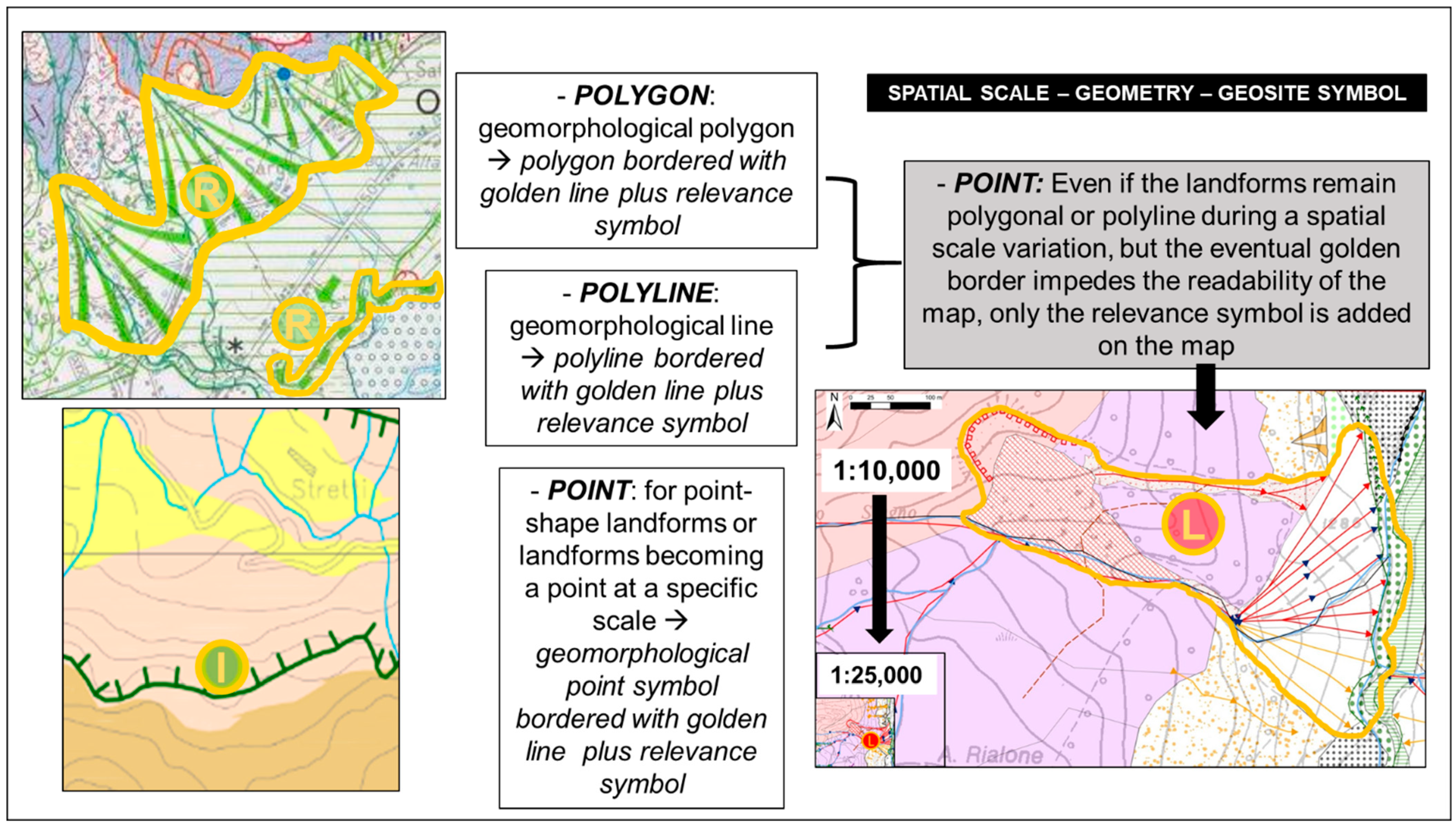
3.2. The Issue of Spatial Scale

As stated before, the geosite characteristics, and particularly their size, are conditioning factors for their representation on maps. Single isolated landforms, such as karst depressions, may be represented as points. Others, such as glacial cirques or paleochannels, are polyline features that are best depicted as polylines, while large and complex landforms need to be represented as polygons. The choice of the representation as point, polyline or polygon is strictly dependent on both the shape and size of the element, but it depends also on the scale of the map and, consequently, on the aim of the map. More in detail, in the present paper, based on previous works [1,2,4,5,41,45,99,104,107,108,119,120,121], nine categories of geosites have been established based on their geometrical (A) and genetic (B) characters and (C) their scientific and territorial importance [4,119,122,123,124] (Table 1).

3.3. A New Legend for Mapping Geosites

The proposal of a legend for mapping geosites is quite critical. The question is how to represent geosites of geomorphological interest, which coincides with landforms, considering that geomorphological mapping has its own legend. After various attempts, a procedure for mapping geosites on geomorphological maps was proposed after discussion within the AIGeo WG. The driving idea of the proposal is to avoid new symbols added in the standard geomorphological legend but to highlight punctual, linear and areal geosites already mapped as landforms with a different colour from the ones identifying geomorphic processes. Moreover, the possibility to add information and other data about geoheritage with simple symbols or letters was investigated. These latter data can be added on the map, in the connected geodatabase or on separated documents.
Since all graphics symbols used in the legends of case studied are based on the “New Italian guidelines for geomorphological mapping” [59], a sample of symbols created following embedded QGIS format style (.qml) has been made available for free testing and improvement at https://www.geositlab.unito.it/jom/ (accessed on 10 October 2021). The package includes styles and instructions for applying legend to both geomorphological and geosystem services mapping [125].
As the graphical representation changes with the spatial scale of the map, we decided to focus the proposal to the scale 1:25,000–1:50,000, which are the common scale for geomorphic surveys and mapping at national scale level, corresponding to the official geomorphological maps by ISPRA covering the Italian territory [58,77].
Point symbol: a circle with “gold”-coloured edge. A capital letter in the centre of the circle indicates the relevance of the geosite: L (local), R (regional), N (national) G (global) (Figure 6).
The symbol can be used both for point geosites and for polyline or polygon landforms that cannot be drawn in relation with the scale of the map (Figure 7). The circle filling is realized with the colour of the genetic processes (following the geomorphological legend), with a degree of transparency useful to make the background visible. If the geosite is a composed landform, the filling colour will correspond to the dominant or more recent geomorphic process (Table 2).
Polyline and polygon symbols: a curved line bordering the geosite. The line is gold coloured. It can be used when landforms can be mapped as they are recognizable at the spatial scale of the map. The geosite contained within the bordered area is represented with the official symbols, colours and shades (e.g., Figure 7). A circle with a capital letter in the centre will indicate the relevance of the geosite: L (local), R (regional), N (national) G (global) (Figure 6). The circle filling is realized with the colour of the genetic processes.

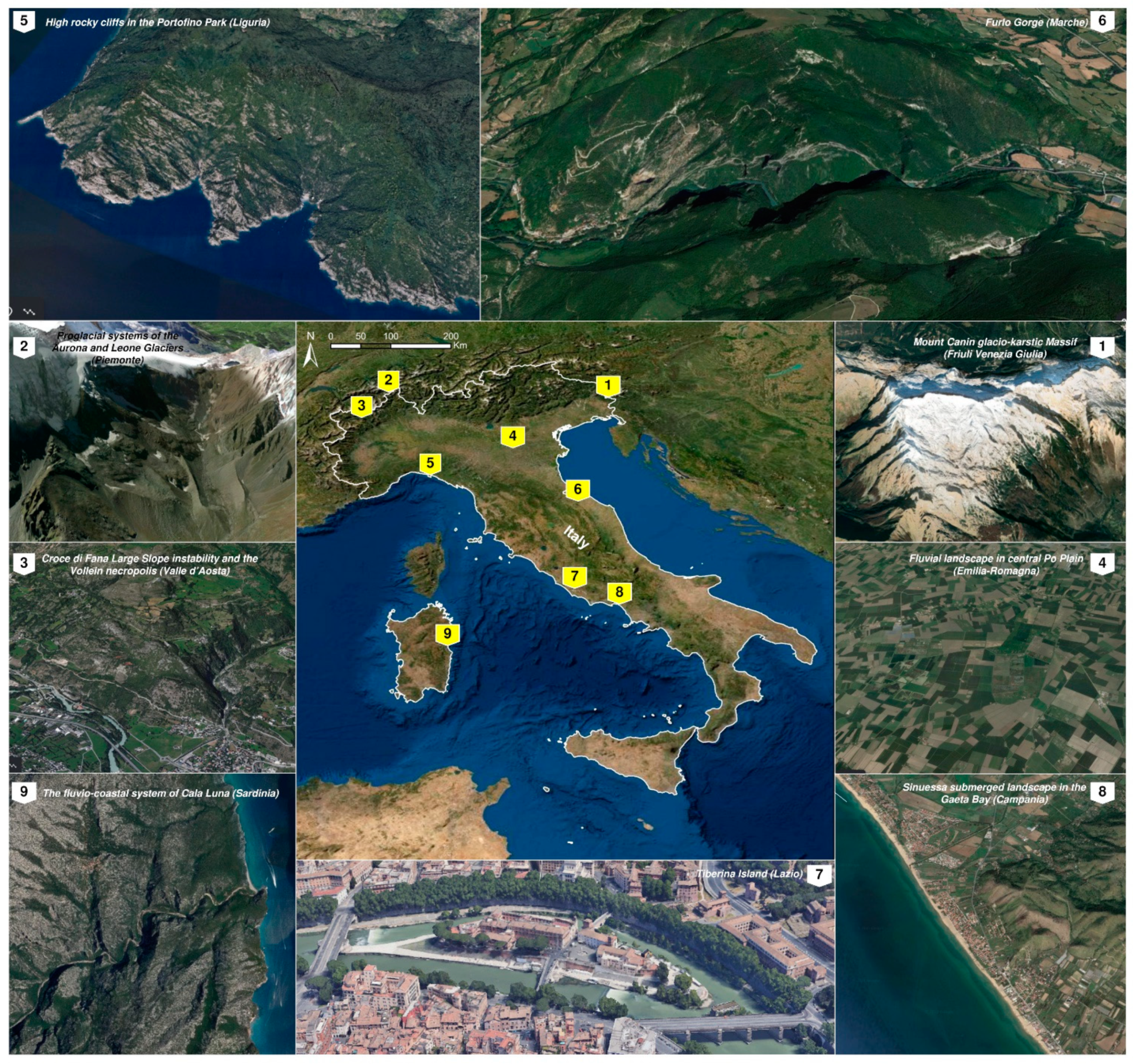
4. Italian Case Studies

As a result of the activities carried out by the AIGeo Working Group “Geomorphosites and Geodiversity” during the last years, some examples of experimental tests on mapping sites of geomorphological interests at different scales (1:25,000 and 1:50,000) have been developed and are here presented (Table 3) (Figure 1).

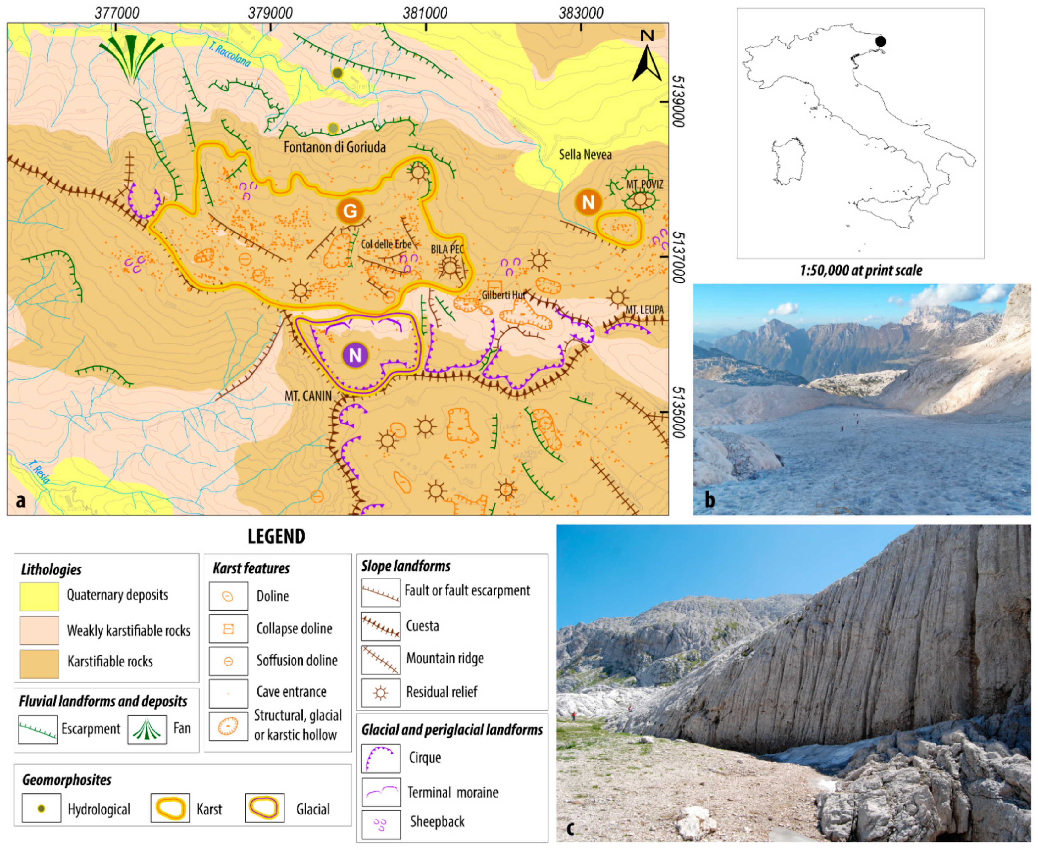
4.1. Mount Canin Glacio-Karstic Massif (Cucchi F., Finocchiaro F.)

The Mt. Canin Massif (2587 m) have been selected being one of the most spectacular examples of alpine karst in Italy, due to the richness and variety of its surface forms and the size of deep caves that occur within it [126] (Figure 1, site 01). Only its western side is included in a regional protected area called “Parco delle Prealpi Giulie”, and it has recently become part of the Man and Biosphere UNESCO Network. At the same time, in sharp contrast with the naturalness of the places, the landscape near the Gilberti Hut and Mt. Poviz is ravaged by ski slopes and lifts. In Slovenia, the eastern part of the massif is part of the “Triglav National Park”, whilst on the southern side, ski lift facilities connect Italian and Slovenian ski runs. As in the Dolomitic region and other natural parks, the coexistence of wilderness and winter sport business is really problematic.
The massif rises in the Western Julian Alps along the border between Italy and Slovenia and is surrounded by four river valleys: the Raccolana, the Resia and the Soka-Isonzo valleys belong to the Adriatic basin while the Rio del Lago valley belongs to the Danubio basin. From the geological point of view, the Julian Alps are characterized by thick Mesozoic carbonate formations organized along thrusts with an alpine E–W direction. The stratigraphic sequence of the Canin massif, from bottom to top, consists of Dolomia Principale (Norian), Dachstein Limestone (Norian-Rethian), Oolithic Limestone (lower Lias), Crinoid Limestone (middle Lias-Dogger), Scaglia rossa (Turonian) and Flysch (Senonian) [127]. These formations, overthrusted and partially upheaved towards the north, show an anticlinal arrangement faulted along the axis and transversally. The E–W-oriented faults run north to the border ridge between Italy and Slovenia, dividing the whole massif into two opposite monoclinalic blocks. The landscape of this area is characterized by a wide surface of limestone uncovered by soil, shaped by glacial erosion and carved by really intense karstification. Bare limestone surfaces extend for more than 20 km2, about one third in Italy.
In the area, two composite geosites and two simple geosites have been identified (Figure 8).
On the northern side of Mt. Canin’s peak, a polygon composite geosite is represented by a small circular glacieret, the only remanent of a single ice mass covering a surface of about 2 km2 at the end of the XIX century (Figure 8). This glacieret is the lowest altitude ice mass of the Southern Alps. The late Quaternary ice retreat has left trimlines on slopes, till deposits, sheepback and striated surfaces. Probably during the LGM, the reliefs of Mt. Poviz (1978 m) and of Mt. Bila Pec (2146 m) emerged from the ice mass as nunataks. The glacial landscape and landforms are everywhere superimposed by corrosion forms.
Actually, a continuous display of alternating micro- and macro-karst forms occur on the uncovered limestone outcrops on the plateau: from dolines to snow shafts, from solution grooves to meandering karren and from grykes to kamenitzas. Dolines have a diameter of about 10 m and are often aligned along tectonic lines. Two areas are particularly impressive: the geosites of “Col delle Erbe” (1988 m) plateau, a polygon composite geosite, and the SW side of Mt. Poviz, a karren field constituting the simple areal geosite [128] (Figure 8). In the former area, loads of cave entrances open and have always been the object of speleological explorations in the last 50 years. Recently, in the summer 2019, a passage between two narrow tunnels was opened and explored, joining two large cave systems in the wider cave in Italy, of more than 70 km in length. In the surroundings of the Mt. Poviz, on some steep limestone walls, vertical grooves, which are several meters long, develop in a sub-parallel way with an impressive frequency.
From a hydrogeological point of view, Mt. Canin is a unique structure, an independent part of the Julian Alps, being bounded on all sides by noteworthy karst springs [129]. In the Raccolana Valley, the simple punctiform geosite “Fontanon di Goriuda” cave acts as resurgence of the NW sector of the massif and gives rise to a scenic waterfall more than 30 m high.

4.2. Proglacial System of the Aurona and Leone Glaciers (Bollati I., Pelfini M.)

This complex geomorphosite is located along the Alpe Veglia Glaciological Itinerary [30], in the Lepontine Alps (Figure 1, site 02). The area is interested by the outcrop of rocks of the Lower Pennidic nappes, the deepest part of the Alpine orogeny. The lithotypes characterizing the area are mainly represented by massive and foliated metamorphic rocks, including [130]. From a geomorphological point of view, the area is dominated by glacial and paraglacial processes (Figure 9b) (sensu [118]) since glacial dynamics are gradually leaving space to water- and gravity-related processes favoured by deglaciation. The area has been selected as a representative case study for morphodynamics of a proglacial system. In particular, the proglacial areas related to the Aurona and Leone Glaciers constituting the system are undergoing a progressive widening since the glaciers, characterized by different dynamics, are fast retreating (Figure 9c).
The Aurona glacier, occupying the head of the valley, is characterized by a flat proglacial area, running along an ESE–NNE structural line, probably related to the Veglia Fault Zone [131], and it is bordered by lateral moraines, related to the Little Ice Age. The proglacial area was featured, during the 1950s, by a proglacial lake gradually infilled and substituted by a sandur with a braided river. The lateral moraines, few tens of meters high, act as an element of disconnection between the valley slopes affected by water-, snow- and gravity-related processes and the little sandur. Moraines are themselves affected by paraglacial-type transformations: a pervasive gullying, producing typical pseudo-badlands landforms and local debris and earth flows (Figure 9b). This configuration reproduces an emblematic situation of paraglacial modifications affecting Alpine environments [132,133]. The Aurona glacier area was the object of local customs concerning the relation between glacier activity and possible consequences on human practices in the area (e.g., sheep-farming).
The Leone glacier, on the southeastern corner of the valley, is partially hanging on a very steep slope. Its glacier foreland is steeper, presenting an evident rocky glacial step that separates, since the 1990s [134], the current glacial snout from an overdeepening area, filled by abundant debris and closed by lateral and frontal moraines related to the LIA. The central portion of the depression is occupied by a debris body, probably with an ice core, showing flow structures indicating a potential rock glacier [130].
The whole area has a high aesthetic value, it is accessible through a thematic excursion trail (i.e., Alpe Veglia Glaciological Itinerary; [135]), along which several potential sites of interest are located, increasing the global value of the area.

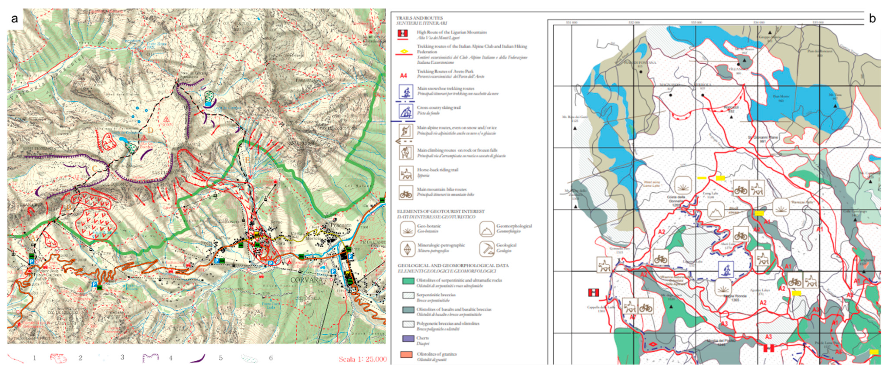
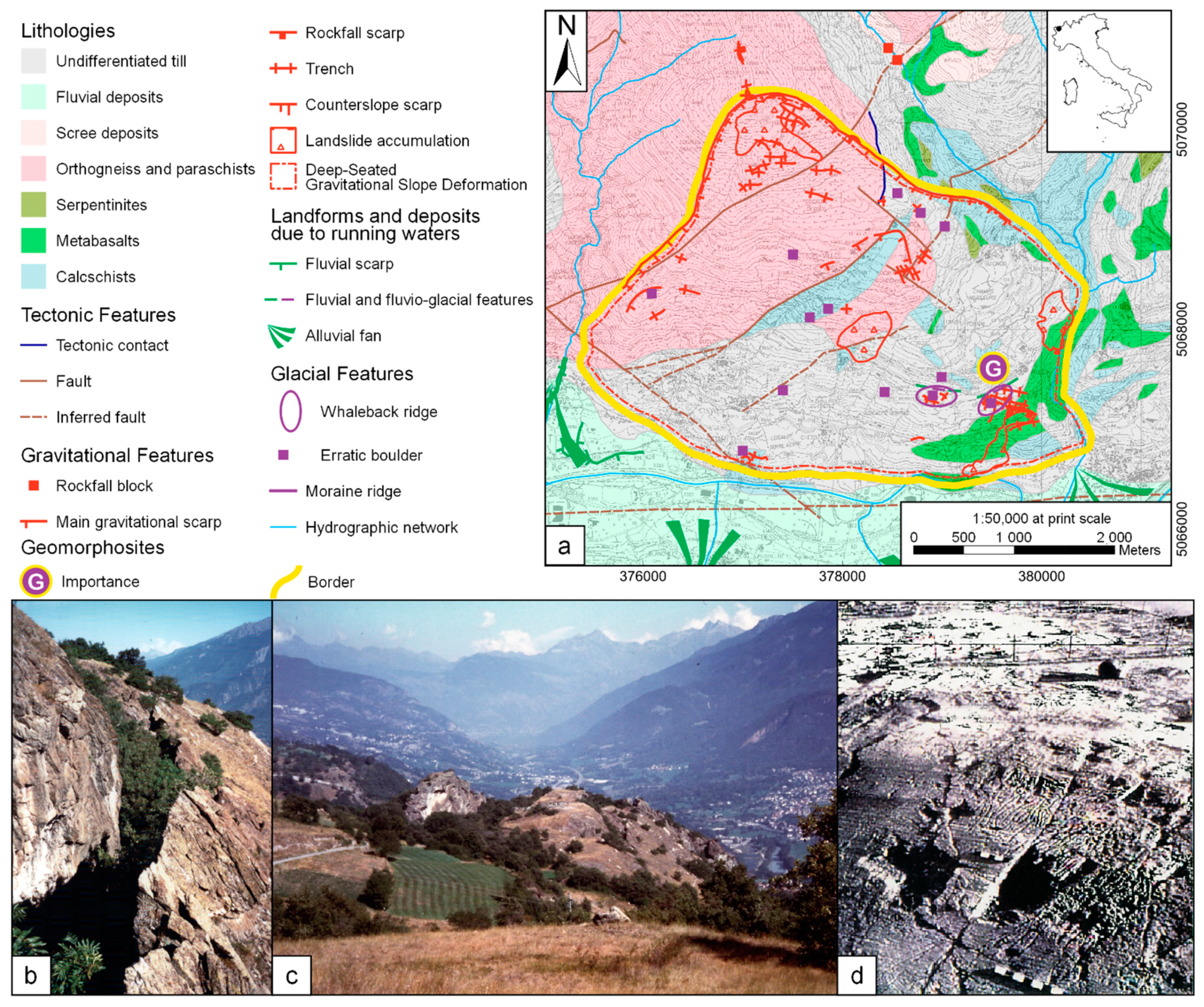
4.3. Croce di Fana Large Slope Instability and the Vollein Necropolis (Giardino M., Perotti L., Tognetto F.)

The geosites are located on the central sector of Aosta Valley (Western Alps), left orographic valley side between Quart and Nus towns (Figure 1 site n. 03) (Figure 10). Geological, geomorphological and archaeological studies have been carried out here to highlight possible relationships between the Croce di Fana large slope instability phenomena of post-glacial age [136,137] and the Vollein geoarchaeological site, consisting of a necropolis with 66 cist-tombs, rock carvings and of a group of pottery and lithic finds (flint and quarz), witnessing a cultural context from the Ancient Eneolithic up to the beginning of the Middle Bronze Age [138,139,140,141].
The Croce di Fana slope is a complex geomorphosite because of the association of deep-seated gravitational slope deformations (“DSGSD” features: scarps, trenches, elongated depressions, counterslope scarps and isolated ridges), with landforms related to glacial erosion and deposition (whaleback ridges, rochees moutonnees, spillway channels, erratic boulders, glacial and fluvioglacial deposits) [142]. The local litho-structural units (calcschists and associated methabasalts of the Piemontese Domain; gneiss of the Lower Australpine) [143] show a very tight isoclinale polyphase structure, crossed by important brittle discontinuities; at the mesoscale, the bedrock is often extensively fractured, sometimes highlighting signs of an in-progress opening of the fractures, rotation and displacement of the single rocky polyhedrons.
The analysis of the kinematic indicators both within bedrock and Quaternary deposits, the detailed mapping of markers of surface deformation within natural and anthropogenic landforms and structures, together with the archaeological data and precise topographic measurements allowed us to specify the mechanism of the gravitational sliding phenomena.
The above-described geomorphological and geological evidence of deep-seated gravitational slope deformation cover an area of about 12 km2, thus being represented as a polygon (Figure 10) and being of regional importance for its representativeness within the alpine geomorphological landscape of the Aosta Valley Region. A small-size, isolated ridge with archaeological findings at the Vollein necropolis have been represented as a point of global importance (Figure 10) due to their relevance, together with the St. Martin de Corléans site (Aosta Valley) as outstanding Neolithic remains within the Alpine prehistoric archaeological record [140,144,145]. Since the whole set of landforms and processes are related to more than one dominant genetic process, both Croce di Fana and Vollein have to be interpreted as complex geomorphosites. Moreover, they can also be considered as evolving passive geomorphosites (sensu [74]) for their inherited landforms that are (and have been) modified by current (and past) active processes, different from the primary genetic ones. In fact, geomorphological evidence shows that gravitational deformations displaced glacial patterns. The intersections between all these geomorphological elements and the traces of anthropic activity along the slope show that the large slope instability is still active. Moreover, studies made clear that, already during the prehistoric occupation, a strategy was carried out in order to minimize the effects of the gravitational dynamic that could cause dangers to the visitors of the site. Other than scientific and cultural values, both Croce di Fana and Vollein locations are of aesthetic interests, because the visit to the geosites also offers a wonderful balcony over the alpine landscape of central Aosta valley [142].

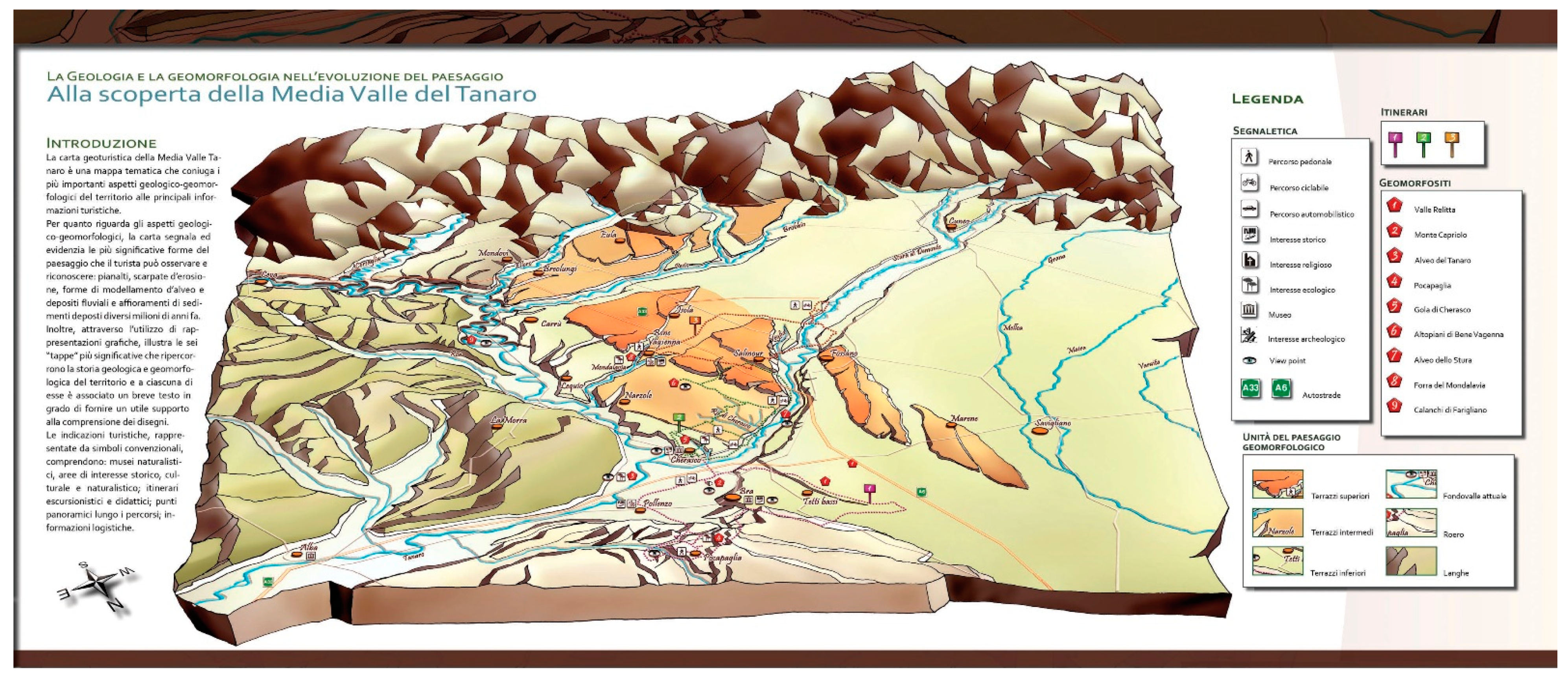
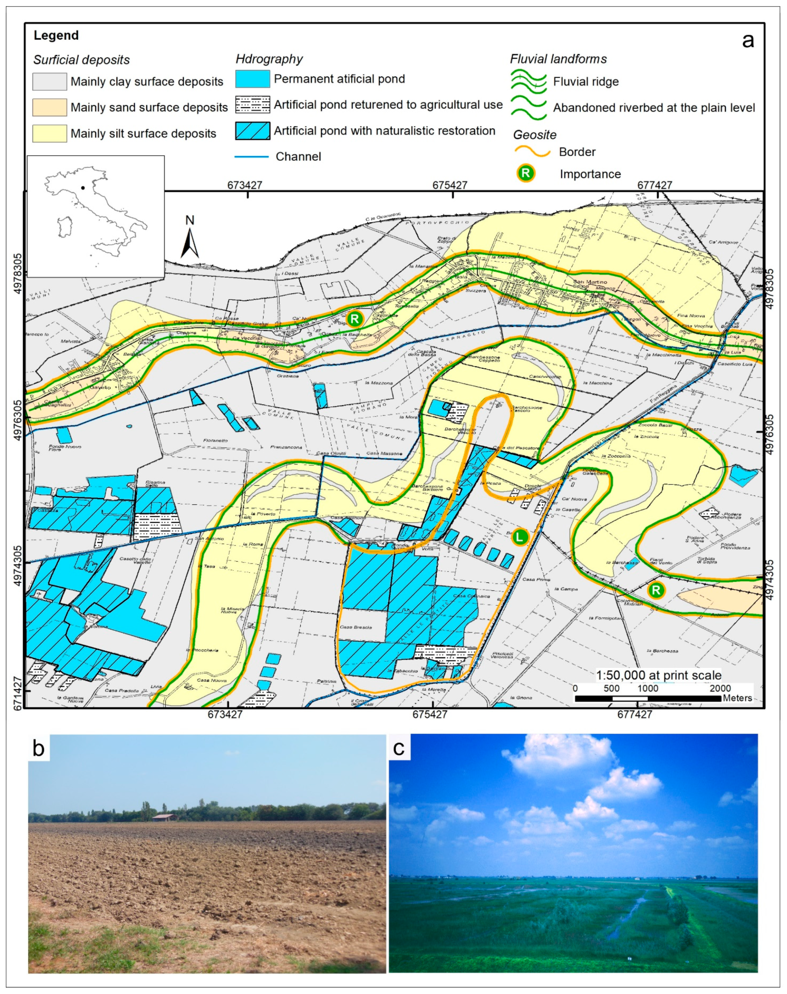
4.4. Fluvial Landscape in Central Po Plain (Castaldini D., Coratza P.)

The study area is located in the lowest sector (altitude about 10 m a.s.l.) of the Po Plain between Modena and the Po River (Figure 1, site 04). The geomorphological characteristics of this sector are mainly the result of the evolution of the Po, Secchia and Panaro rivers (cfr. [146]). Many fluvial ridges, due to the past activity of ancient watercourses, are found; depressed areas, known with the local name of “Valli”, are located in between the fluvial ridges.
The particle size of surface alluvial deposits ranges from mainly sand and silt, in correspondence of the abandoned riverbeds, to mainly clay in the depressed areas where the flooding waters were addressed. The thickness of alluvial deposits varies from hundreds of meters to one thousand meters in relation with the depth of the buried Apennine structures known as Ferrara Folds [147].
In the study area, three simple areal geosites related to fluvial processes are located; they are catalogued in the “Inventory of the geosites of the Emilia Romagna region” (http://geo.regione.emilia-romagna.it/schede/geositi/) (accessed on 10 October 2021) (Figure 11).
The first geosite of regional interest is a meandering palaeoriver, which, in the literature, is known as the “Barchessoni palaeoriver” (e.g., [148]). This palaeoriver is situated between the Po, Panaro and Secchia rivers in an altimetric depression. The “Barchessoni palaeoriver” is well depicted on remote sensed images on which fluvial bends are clearly visible. According to different authors, it was defined as a Po palaeoriver active in the last centuries BCE, as an Apennine palaeoriver inactive in the Roman time, as an old course of the River Secchia and as a Po palaeoriver active in the IV–III millennium BCE. In the area where the Barchessoni palaeoriver is located, a few hundred archaeological settlements were found, distributed between 2300 BCE and the 8th century CE [149]. The archaeological remains have revealed that this palaeo-course of the Po River was already active in the Bronze Age. The “Barchessoni palaeoriver” testify an ancient southward position of the River Po respect its present one. On the whole, from the Bronze Age to the Late Middle Ages, the R. Po flowed in a belt about 15 km wide, shifting from south to north.
The second simple geosite of regional interest is “Valle Le Partite” which is located between the meanders of “Barchessoni palaeoriver”; it corresponds to a small part of a wide sector which has been inundated many times by the Po River and therefore there are clayey flood-sediments buried the older hydrographical features, morphology and archaeological settlements. The most recent inundations occurred in 19th century in November 1839, October 1872 and June 1879 [150,151]. The floodwater reached the maximum height of 7.60 m on the occasion of the October 1872 inundation. The level reached by the floodwater, which rested on the terrain for few years, is still artificially marked on the walls of some houses and of the church of a nearby village. In the last decades, the realization of artificial ponds, for fish farming, for sport fishing or as naturalistic oasis, has returned to the depressed areas, even in limited zones, the characteristics of wetland, thus restoring their natural appearance.
In the northern sector of the study area, the “Gavello fluvial ridge”, a simple geosite of the “local” degree of interest, rises 2–3 m higher than the surrounding plain. This geosite corresponds to an ancient water way belonging, in succession, to the River Po (in pre-Roman times), to the River Gabellus (in Roman and high medieval times) and to the River Secchia up to the XIV century [152].
All three geosites here described correspond to relict fluvial landforms.

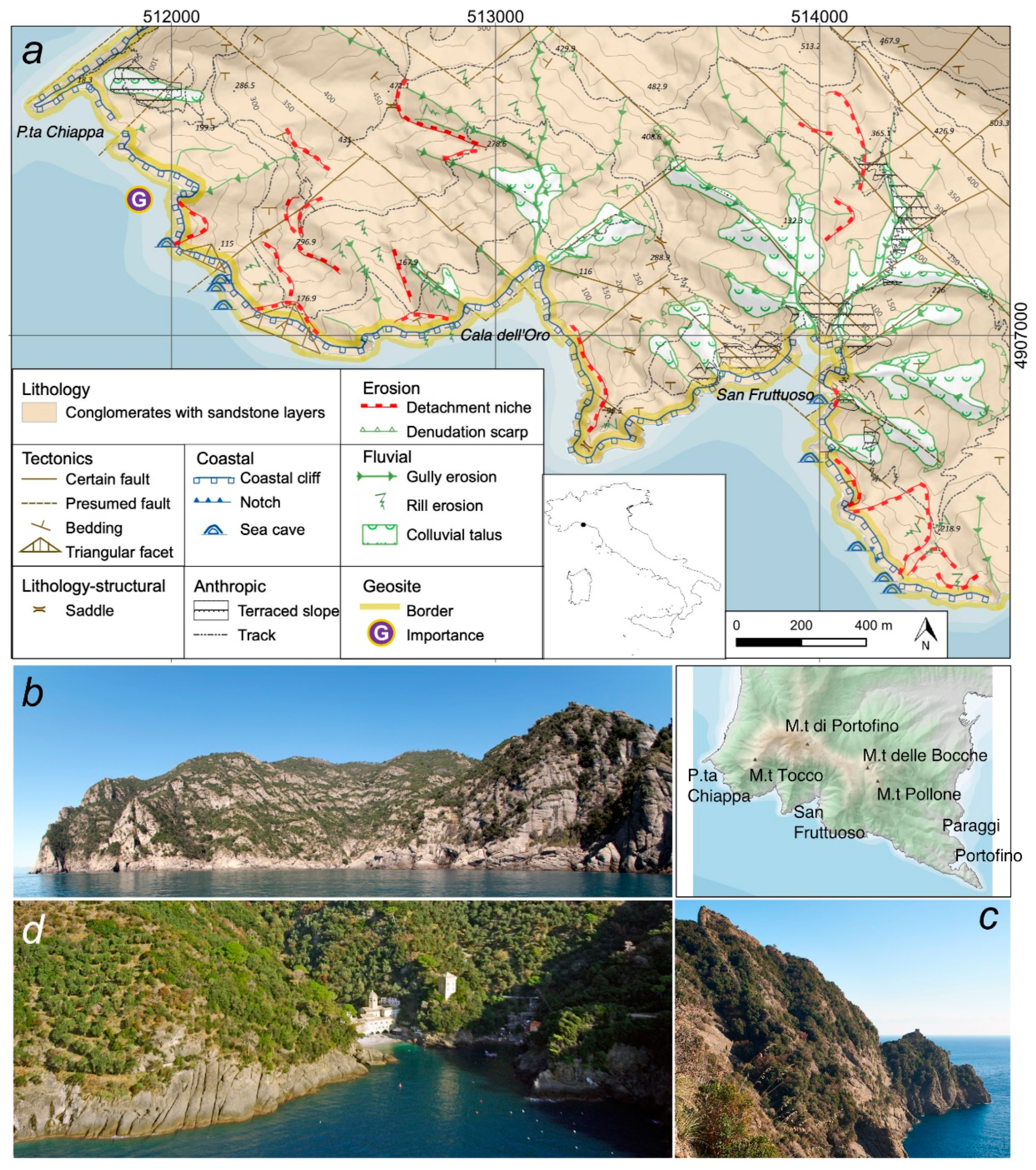
4.5. High Rocky Cliffs in the Portofino Promontory (Faccini F., Brandolini P., Paliaga G.)

The geosite is located in the southern part of the Portofino Promontory, within a natural park, both terrestrial and marine, protected since 1935 (Figure 1, geosite 05) [69].
The morphology of the Promontory is characterized by a mountain ridge with different elevations including Mt. Tocco (543 m), Mt. di Portofino (610 m), Mt. delle Bocche (506 m) and Mt. Pollone (472 m) [40].
The geology is made by the conglomerates (Oligocene) along the southern slope, while the marly limestone flysch (Cretaceous-Sup Paleocene) outcrops are in the northern part of the promontory. The conglomerate is mainly characterized by clasts of marly limestone of centimetric or metric size and secondarily by sandstone. The conglomeratic complex shows variable attitude: in the area of San Fruttuoso, it is towards the S, while at Punta Chiappa, it is towards the SE. The dips are no more than 20°. Two lineation systems with some faults are identified, with NW–SE and NE–SW directions; their superimposition causes the degradation of the bedrock in large blocks [40,153].
From a geomorphological point of view, the southern slope of the Portofino Promontory, with an average inclination of the slope ranging between 45° to 65°, represents an outstanding coastal geomorphosite as an example of the evolution of high conglomerate cliffs (Figure 12).
The composite areal geosite is characterized by a high rocky coast, with heights that exceed 100 m a.s.l., affected by the sea wave action of SE and SW winds. The conglomerate cliffs represent a unique landscape in the Mediterranean area, also with the presence of sea caves and notches. These marine landforms interact mainly with processes due to gravity and running waters. Among the processes historically known, we can report the debris flow of 25 September 1915 that caused severe damage to the village and the accumulation of the San Fruttuoso beach [31,40,154].
Other landforms due to karst-like phenomena and alveolar sculptures are recognized, too. The Ligurian Speleological Inventory lists 20 caves in the conglomerate. Their origin is prevalently tectonic although, to a much lesser extent, some are due to chemical-physical dissolution or processes linked to the sea wave action. Within anthropic landforms, dry-stone wall slope terracing is a very common farming technique, which dates back to ancient times. Terracing has deeply modified the geomorphological, vegetation and dwelling landscape at a slope scale. Well-preserved examples of slope terracing are found in the San Fruttuoso catchment [155,156,157].
The selected geosite has a high scientific value due to a representative high rocky cliff evolution; landscape value is added as the conglomerate cliff as the distinctive element of the Portofino Park, which significantly increases its overall fame. The park is frequented by about one million tourists, hikers and divers every year. The area has a trail network developed for over 80 km, walked along during all the seasons [158].
The geosite is accessible through a really impressive footpath that runs along the top of the cliff between Punta Chiappa and San Fruttuoso, or by using the boat [159].

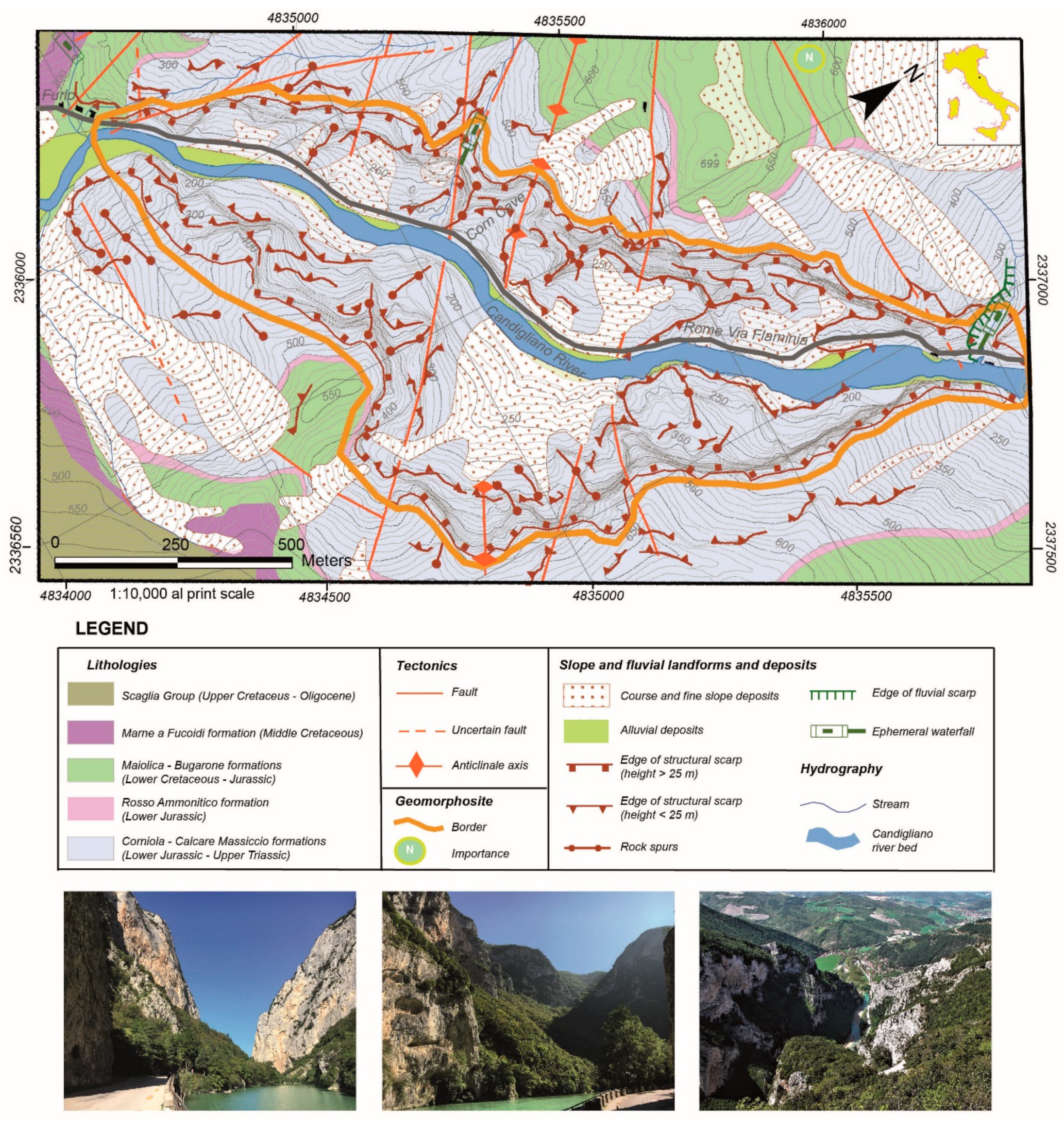
4.6. Furlo Gorge (Nesci O., Valentini L.)

The Furlo Gorge is a complex geosite of the Furlo National Reserve (Figure 1, site 06). The Gorge is the best example of the several canyons that strongly characterize the Apennine landscape cross-cutting the calcareous anticline ridges. The study and comprehension of its genesis and evolution mechanisms prove to be a matter of the utmost importance for both scientific and educational purposes to enlighten the evolution history of the territory [160,161]. The excellent and abundant outcrops of the upper Jurassic-Paleogene terms of the Umbria-Marche stratigraphic succession, together with eminent fossil localities and well-exposed tectonic structures, give this site a major geological-palaeontological interest, too. The whole site encloses a lot of key landforms and landform assemblages crucial to understanding the geomorphological history of this area and effective for the scenic beauty of the area (Figure 13).
The Gorge is cut by the Candigliano River (Metauro River basin) into the massive to stratified Jurassic-Paleogene calcareous and marly-calcareous formations of the Umbria-Marche Succession. The Gorge crosscuts the anticline relief of Pietralata-Paganuccio Mts. (the so-called “Monti del Furlo”, Furlo Mts., according to a local denomination) just in correspondence of its axial culmination, stressing a crucial fault-related structural control on its development. A dam, built between 1919 and 1922, originates an artificial lake inside the gorge. The Gorge sidewalls hang over 500 m high on the valley bottom: their persistence, continuity and shape depend on the massive resistant limestone (Calcare Massiccio Fm.) that constitutes them. The control of joints and fault systems on the sidewalls is apparent, primarily marked by their segmentation in quite-rectilinear segments; likewise, overhanging cliffs and straight minor scarps, degradation niches, crests and spurs aligned along fault-traces occur all along the canyon. Minor karst (solution flutes and pits) and paleo-karst features (remnants of small tunnels) are also apparent, in particular close to the “Grotta del Grano” (i.e., “Corn Cave”) site.
Small hanging valleys join the hillsides: dry for most part of the season, after intense rainfalls, they can originate attractive waterfalls. Because of the steep morphology of the sidewalls, all along the valley sides, rich evidence of rock-falls of different sizes is found, consisting of large boulder accumulations and scars on the sidewalls. Significantly, also in Roman times, repeated landsliding affected the road crossing the Gorge, compelling the Romans to chisel two tunnels out of the rock.
The geo-naturalistic components integrate with historical/archaeological ones: construction works of the Roman Via Flaminia (walls, huge cut off rocks and two tunnels) occur all along the gorge).
The preeminent geo-naturalistic components of the site perfectly integrate in a substantial historical/cultural framework. Since in the past the Gorge was the primary natural way connecting the coast with the Apennine mountain passes, it preserves impressive construction works of the Roman consular Via Flaminia (e.g., over 300 m of walls, ca. 1500 m3 of cut off rocks and two tunnels, one of them the so-called Vespasiano tunnel, 76 BC, still in use).

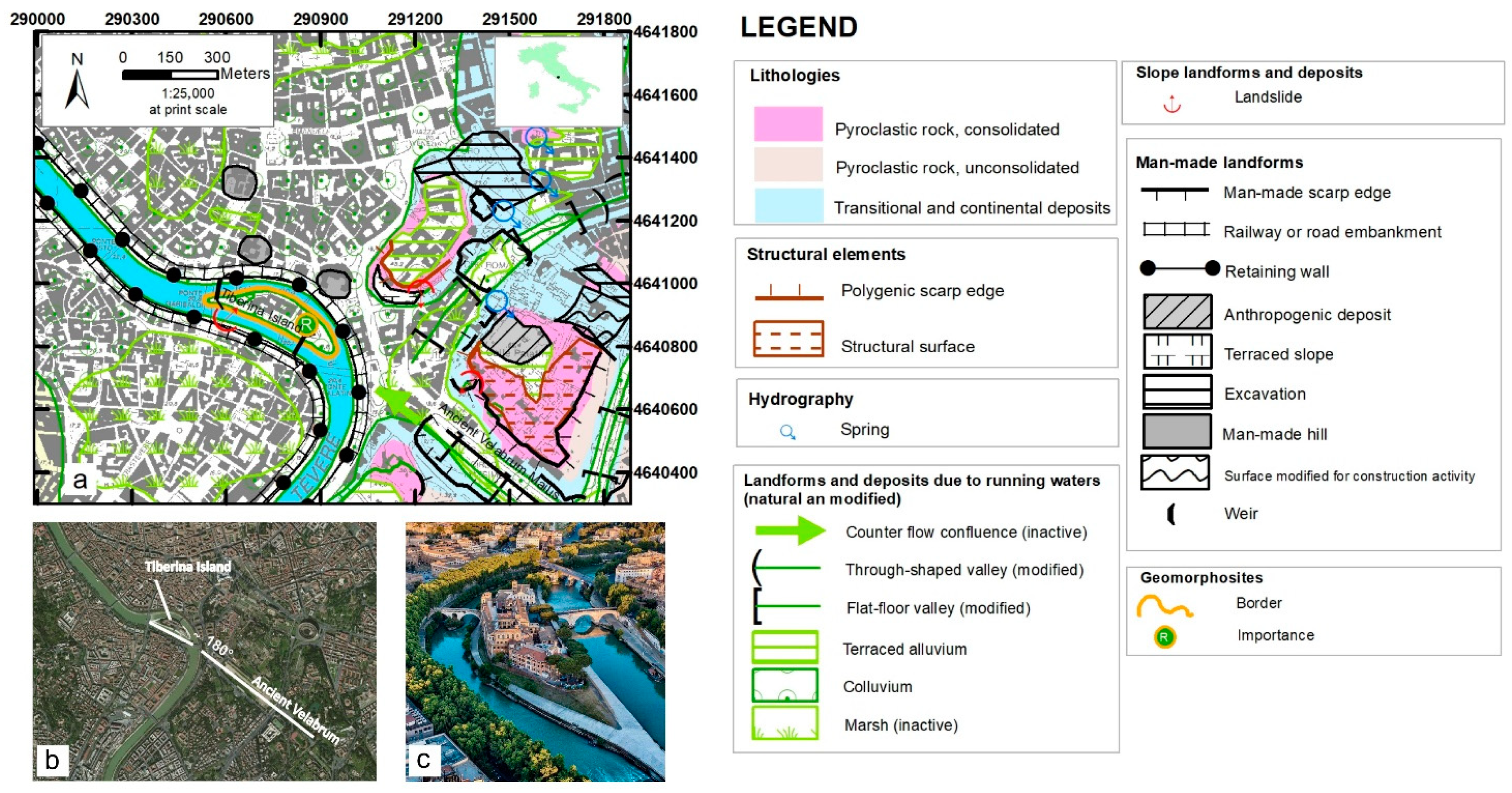
4.7. Tiberina Island (Pica A., Del Monte M.)

Tiberina Island is part of Rome’s city image and fame thanks to its elongated shape flowing in the Tevere River but fastened to the riverbanks through historical stone bridges. In addition to this value, the geomorphological origin and the historical and legendary values of the isle make it a very interesting urban geosite (Figure 1, site 07). Tiberina Island is located in the historic heart of the Rome city, since the beginning of Roman history urbanization significantly modified the local morphology (Figure 14).
The Tevere River collected the waters of several tributaries in this area, and ancient marshes have been characterizing the alluvial plain [162,163,164]. The main tributary valley, the Velabrum Maius, flowed from the left into the Tevere. The valley was set on a tectonic line which goes beyond the confluence and Tevere’s west alluvial plain [165,166], this constraint caused a counter-flow confluence, forcing the Velabrum entering the main river with an angle of 180°, next to a wide meander.
The origin of Tiberina Island in this position is explained by the particular confluence described above: In fact, the Velabrum waters favoured the genesis of a river bar hampering the Tevere sediments’ transport, due to abrupt decrease in water speed and loss of competence of the main river’s flow to transport [167]. Over time, the growth of the bar generated the island; drillings on the Tiberina Island [168,169] confirmed the constitution of the island of river sediments, specifically sand, gravel, clay sands and clays.
The simple geosite of Tiberina Island is a rare example of a river island along the urban axis of an Italian river, the landform witnesses the natural morphology deeply modified by urbanization since 2500 years ago; it is an significant example of an urban geosite (Figure 14).
The island is inhabited: An important hospital works here, and together with San Bartolomeo Basilica they testify the cultural, traditional and spiritual value of the place [162]. The basilica and the hospital are the icons of the Esculapio ancient temple spirituality and mission, based on the two legends telling about the origin of the island: the first one related to the roman kingdom’s historical events merged with natural phenomena; the second related to a pestilence affecting the city, solved by the mythical intervention of the snake sacred to Esculapio (pagan god of medicine). These legends have conditioned the island’s public use and symbolic value in history.
For the extraordinary scientific and cultural values described above, the geosite has a level of regional importance. Tiberina Island is not exposed to long-term vulnerability factors, although it and the entire urban river axis are subject to floods. In fact, the phenomenon is controlled by dams located upstream and the shape profile is sealed by masonry works. The geosite is the subject of various multidisciplinary and scientific publications [169,170] and a proposal for geo-tourist enhancement, carried out in papers and digital geo-tourist guide [167].

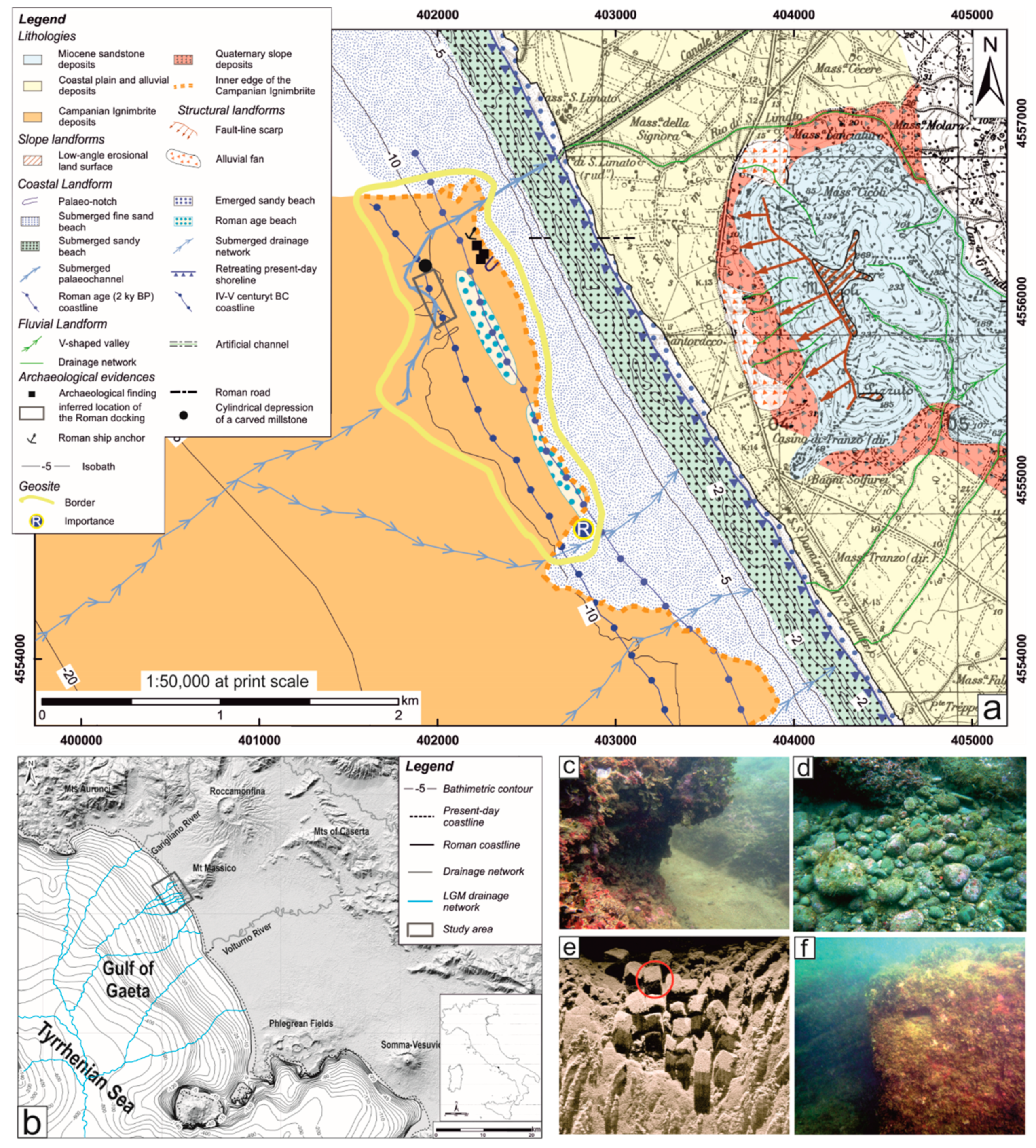
4.8. Sinuessa Submerged Landscape in the Gaeta Bay (Gioia D., Minopoli C., Pennetta M., Trocciola A.)

The Sinuessa submerged complex geosite is located in the central sector of the Gaeta Bay (in the northern sector of the Campania region) (Figure 1, site 08), bounded by the carbonate morphostructure of Mt. Aurunci to the north and the Campi Flegrei volcanic district to the south, at the foot of the western termination of the ridge of Mt. Massico (Figure 15). The submerged sector of the Gaeta Gulf has a flat topography [171] with a roughly trapezoidal shape, which is delimited landward by impressive NE–SW- and NW–SE-trending fault-related slopes [172]. The area is featured by a series of NE–SW oriented channels ([173,174] and references therein), which originate in the higher-altitude sectors of Mt. Massico. These channels are the present-day geomorphic evidence of ancient and more developed river networks with a dendritic pattern [Pennetta et al., 2016a], which deeply dissected the landscape during the LGM (~18 kyr BP). Their traces are the meandering channels modelled into the ignimbritic bank, previously emplaced (~39 kyr BP), on which the submerged archaeological site lies. The geosite is characterized by the Campanian Ignimbrite deposits distributed along a narrow belt located about 650 m to the present-day beach and at a depth of −7 m. This sector hosts the archaeological remains and is featured by articulated morphology with alternating 1–2 m height scarps and decametric depressed areas. These morpho-sedimentary features are due to intense morphoselective erosion in a continental environment, as inferred by the occurrence of fractures, deep incisions and small basins in the outcrop sector of the ignimbritic flows [175].
The area is characterized by gravel palaeo-beaches and marine landforms (i.e., two sea notches) located at the same depth of the ignimbrite deposits suggesting that this sector was emerged and attended by Man in Roman times, even for activities related to port facilities. Submerged palaeo-channels, in alignment with current watercourses on the mainland, dissect the shoal. These channels were carved in a subaerial environment during the last glaciation (i.e., after the tuff deposition) and then were drowned by sea-level rise. In the submerged palaeodrainage network of the study area, the erosion channels of lower hierarchical order, excavated by runoff along the lines of maximum gradient, caused further fragmentation to the surface. Thus, small rocky outcrops are isolated, contributing to the genesis of depressions along the marine terrace, then filled by bioclastic sediments. Distances between the sides of the main channels, perpendicular to the coast, slightly increase towards the palaeomouths as a result of the interplay between fluvial and marine processes. Submarine surveys along the coastland of Sinuessa highlighted a depressed area hosting 24 concrete cubic elements in the northernmost sector of the shoal. These artifacts (pilae) are typical of Roman maritime structures widespread along the southernmost Phlegrean coast. Geological evidence and archaeological findings indicate an older palaeosea-level at about 11 m [175]. At about 1 km from the coast, a man-made cylindrical depression with a diameter of about 1 m was found. Such a geometric depression is the quarrying of a millstone, wherein the ring of extraction is always greater than the dug-out millstone. The use of millstones dates back to 2500 years BP onwards in the Hellenistic period. Apart from the high cultural value of the discovered archaeological ruins of the study area, the geosite represents significant evidence of the complex interplay between tectonic-induced subsidence and glacio-eustatic processes occurring along the Tyrrhennian coast of southern Italy. The discovery of pilae at −8 m depth testifies the depth of the ancient sea-level, suggesting that a significant lowering of the tuff platform, on which such structures are based, occurred. Consequently, since the sea level along this coastal sector has risen about +1.25 m from Roman times to today [176] and considering a maximum tidal range of ±0.5 m, the site with pilae downlifted about −6.5 m, due to the interplay between tectonic deformation and glacio-eustatic processes.
For the extraordinary scientific and archaeological values described above, the submerged geosite has regional importance.

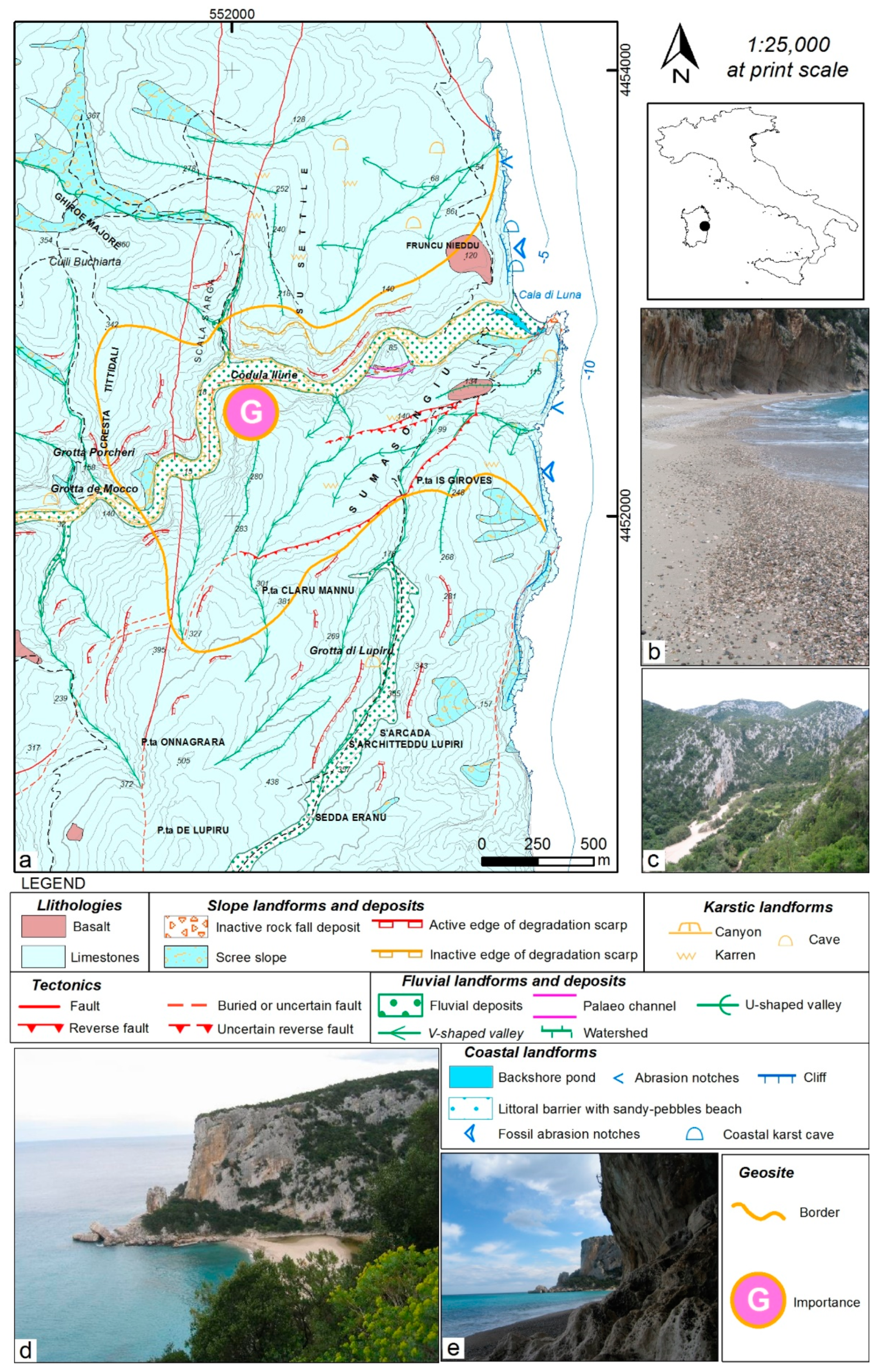
4.9. The Fluvio-Coastal System of Cala Luna (Deiana G., Melis R., Panizza V.)

The complex geomorphosite of Cala Luna is located in the Gulf of Orosei (central eastern Sardinia) (Figure 1, site 08). The Orosei Gulf is a coastal karst area, characterized by a sedimentary sequence of dolomites and limestones of about 800 m unconformably covering a Palaeozoic basement [177,178]. The whole area is part of Supramonte, a carbonate massif of 170 km2 composed of Middle Jurassic to Lower Cretaceous dolostones and limestones in different sedimentary facies. This thick Mesozoic sedimentary sequence covers a peneplained Variscan metamorphic and granite basement. The transgression occurred after a long-during continental period, estimated from Permian to Lower Jurassic. The Middle Jurassic-Lower Cretaceous Sea never reached great depths in the Gulf of Orosei area, and the different carbonate facies evidence several shallow depositional environments, going from lagoons to coral reefs. Lithology is represented of dolostones containing limestone lenses, oolithic limestones and massive fossil-rich outer-shelf, reef, interreef and backreef limestones [179].
During the Middle Pliocene age, an uplifting phase caused an intense erosion–deposition cycle [180]. The sedimentation precedes and is contemporary to the effusion of Pliocene basalts that have given K-Ar ages of 3.56 ± 0.23 to 1.99 ± 0.08 million years [181].
Along the limestone cliffs are present waste stratified slope deposits (éboulis ordonnées) composed of limestone fragments in a reddish clay matrix and aeolian sands visible in karst pockets [182].
The main tectonic alignments of the area can be attributed to an early phase of the Alpine orogeny and especially to the Oligo-Miocene tectonics related to the opening of the Tyrrhenian Sea and to the separation of the Sardinian-Corsican microplate from the South European continent. The whole Mesozoic sequence has been folded and faulted during the Tertiary, displaying main N–S and NE–SW directions [183].
In its whole, the system of Cala Luna is a complex geomorphosites in which landforms and processes strictly interact within three main morphogenetic systems: fluvial, karstic and coastal. It is a fluvio-karst where surface forms and hydrography are subordinated to a very rich subterranean karst aquifers flowing across fractures, and conduits. The deep canyon of Codula Llune ends in the famous pocket beach of Cala Luna (Figure 16).
The hydrographic network is most probably a relic of the ancient drainage pattern that also continues on the shelf for several kilometres up to a depth of at least 120 m [184].
At present, Codula Ilune is the principal river of the study area, and it is activated only after heavy rain periods.
The carbonate rocks, especially the limestones, are affected by intense karstification processes that have created particular and sometimes spectacular landforms and subterranean morphologies. Many typical karst landforms are present in the whole territory, with sinkholes, dolines, caves and many smaller landforms such as kamenitze, solution flutes, etc.
The morphology in the coastal areas is the product of a combination of structural, karst and littoral processes. The coast is characterised by high carbonate cliffs cut by the Codula Ilune stream, forming canyons that end in the sea. At the mouth, a littoral barrier with a sandy-pebbles beach, gave rise to a backshore pond. During exceptional high floods, the stream energy breaks the barrier, temporarily erasing the beach, collecting water from the surface but mainly from subterranean flows. The coastal landforms are related to karst processes and the variations of sea level: coastal and submerged caves, relict tidal notches. During the last glacial maximum, some of these caves had been filled with aeolic sediments.
Many suggestive sea caves, formed by wave action on joints and structurally weaker areas, occurred at the present sea level [185]. The relict tidal notches, developed on the cliff at different heights, testify the sea level variation during the Quaternary and a relative tectonic stability of the area [186,187,188,189,190].
These areas in a whole constitute a unique landscape in which natural aspects largely overrule the human imprint on the environment, and its great naturalistic value has been recognised at a national level. The area was inserted in the National Park of Gennargentu, legally defined but unfortunately never put into practice.
For the extraordinary scientific values and for singular morphology features described above the complex geomorphosite of Cala Luna has a global importance.

5. Discussion and Conclusions

The role of geodiversity and geoheritage is of increasing importance in nature conservation strategies and geotourism activities. According to our preliminary overview on the literature referring to these topics, geoheritage mapping has recently gained a high level of attention not only in the scientific community (e.g., [2,4,5,91,191,192]) but also in the geotouristic context; the great abundance of geotouristic maps (e.g., [91,193,194,195,196]) shows this clearly.
The importance of detailed geological and geomorphological maps for the development of effective territorial planning, management and geoconservation strategies has been demonstrated and unanimously recognised by literature [1,2,5]. These concepts have been also incorporated in the legal framework: in Italy, for example, since 2004 the laws explicitly regulate the management of landscape assets within the cultural assets s.l. to be protected (Codice Urbani; Law Decrete 42; 22 January 2004).
However, there is a lack of a shared methodological procedure for map implementations, where geosite boundaries and features are depicted: This is particularly evident within official geomorphological maps planned at the national level and addressed to territorial planning but also at the international level in the case of geosites or geoheritage sites of global importance.
Therefore, the herein proposed methodology represents a first tentative systematic approach in drawing up cartographic essays for mapping geosites, directed to public boards in territorial planning and sustainable management of a territory. The proposed method allows the exclusion of any overlap or interference with the official geomorphological legend. Moreover, it highlights on single sites as well as on complex or composite sites, from local up to landscape views. The selected case studies show the versatility of the method in term of spatial scale of the representation: small sites as well as groups of sites in a wider area of geomorphological interest, both in terrestrial and submerged areas, can be effectively represented. Certainly, a geomorphological map encompasses all data about topography, landforms and processes, but the presence of a geosite, its boundaries, characteristics and scientific importance are usually not depicted. The gold contour line easily evidences not only the presence of geosites but also their precise localization in terms of boundaries to be considered, for example, for protection measures, their genesis and scientific value, information of paramount importance since decisions about protection perimeter, geosite management or potential interpretative activities will depend on these parameters.
The integration of geoheritage and geomorphological data in a single cartographic document can be considered an innovative and useful tool both for geoconservation and sustainable environmental management. Such a map shows several advantages:
(1)
it offers an overview of both landforms and processes and the main geoheritage peculiarities of a territory;
(2)
it provides information on the state of activity of processes, which can help to evaluate the state of conservation and vulnerability of geosites or the degree of natural and anthropic risks;
(3)
it highlights geosite boundaries useful for decision making in management;
(4)
it represents a functional tool to optimise decisional processes within Territorial Planning, Environmental Impact Assessment procedures and Protection Actions of Natural Heritage.
By sharing the outcomes of our work with other researchers, we aim at promoting the application and test of the methodology in different geological and morphological contexts, but also at improving its procedures in different countries where maybe different strategies of geomorphological mapping are used.
Within this framework, several further developments are possible for analysing relationships between human actions and the environment and assessing abiotic ecosystem services related to natural and cultural sites that are frequently linked with landforms and geomorphosites. As an example, urban geomorphological maps include natural landforms, human-reworked landforms and man-made landforms. The proposed method facilitates targeted analyses and assessments for outlining which landforms represent geosites and hence cultural assets within a delicate environment such as the urban one (see 4.7 case study). Further implementation focused on this topic is of great importance in order to better discriminate the diversity between a variety of sites of interest.
The differences observable in the style of the nine examples demonstrate the flexibility and versatility of the proposed method, which can be easily applied in different contexts. The case studies reported in the present paper may represent a pilot experience for being applied to the different components of cultural heritage.
The diffuse increased use of technology in geoheritage studies has opened up many possibilities for the further development of geoheritage mapping (cf. [197] and references therein). Several examples of virtual field trips [198,199], popularization for a general audience (e.g., [110,200,201] and geoheritage data visualisation on open-source interfaces (e.g., [167,202,203,204]) can be quoted. For this reason, a future development of the proposed methodology will be to use GIS and web mapping technologies. In fact, when GIS functionality is combined with Internet technology, geosite value can be enhanced by the publication of maps data integrated with other information, such as Web-GIS including hyperlinks to images and videos.

Author Contributions

Conceptualization, P.C., I.M.B., V.P., M.P. (Manuela Pelfini) and M.G.; investigation, I.M.B., P.B., D.C., P.C., F.C., G.D., M.D.M., F.F. (Francesco Faccini), F.F. (Furio Finocchiaro), M.G., D.G., R.M., C.M., O.N., G.P., V.P., M.P. (Manuela Pelfini), M.P. (Micla Pennetta), L.P., A.P., F.T., A.T. and L.V.; methodology, I.M.B., P.C., M.G., V.P. and M.P. (Manuela Pelfini); supervision, P.C., I.M.B., V.P., M.P. (Manuela Pelfini) and M.G.; writing—original draft, P.C., I.M.B., V.P., M.P. (Manuela Pelfini) and M.G. writing—review and editing, P.C. All authors have read and agreed to the published version of the manuscript.

Funding

This research received no external funding.

Institutional Review Board Statement

Not applicable.

Informed Consent Statement

Not applicable.

Data Availability Statement

Not applicable.

Acknowledgments

The authors are grateful to anonymous referees for their useful comments and suggestions to improve the original draft. This research is part of the activities of the Working Group “Geomorphosites and Geodiversity” of the Italian Association of Physical Geography and Geomorphology (AIGeo).

Conflicts of Interest

The authors declare no conflict of interest.

References

  1. Carton, A.; Coratza, P.; Marchetti, M. Guidelines for geomorphological sites mapping: Examples from Italy. Geomorphologie Relief Process. Environ. 2005, 11, 209–218. [Google Scholar] [CrossRef]
  2. Coratza, P.; Regolini-Bissig, G. Methods for mapping geomorphosites. In Geomorphosites; Reynard, E., Coratza, P., Eds.; Pfeil Verlag: München, Germany, 2009; pp. 89–103. [Google Scholar]
  3. Regolini-Bissig, G. Mapping geoheritage for interpretive purpose: Definition and interdisciplinary approach. In Mapping Geoheritage; Regolini-Bissig, G., Reynard, E., Eds.; Géovisions, Geography Institute: Lausanne, Switzerland, 2010; Volume 35, pp. 1–13. [Google Scholar]
  4. Bollati, I.; Lenz, B.C.; Zanoletti, E.; Pelfini, M. Geomorphological mapping for the valorization of the alpine environment. A methodological proposal tested in the Loana Valley (Sesia Val Grande Geopark, Western Italian Alps). J. Mt. Sci. 2017, 14, 1023–1038. [Google Scholar] [CrossRef]
  5. Fuertes-Gutiérrez, I.; Fernández-Martínez, E. Mapping geosites for geoheritage management: A methodological proposal for the Regional Park of Picos de Europa (León, Spain). Environ. Manag. 2012, 50, 789–806. [Google Scholar] [CrossRef]
  6. Oya, M. Applied Geomorphology for Mitigation of Natural Hazards; Springer: Singapore, 2001; p. 179. [Google Scholar]
  7. Hayden, R.S. Geomorphological mapping. In Geomorphology from Space; Short, I., Blair, N., Eds.; NASA SP: Washington, DC, USA, 1986; Volume 486, pp. 637–656. [Google Scholar]
  8. Whalley, W.B.; Cooke, R.U.; Doornkamp, J.C. Geomorphology in Environmental Management. A New Introduction. Trans. Inst. Br. Geogr. 1991, 16, 492. [Google Scholar] [CrossRef]
  9. Dramis, F.; Guida, D.; Cestari, A. Nature and aims of geomorphological mapping. In Geomorphological Mapping: Methods and Applications; Smith, M.J., Paron, P., Griffiths, J.S., Eds.; Elsevier: London, UK, 2001; pp. 39–73. [Google Scholar]
  10. Paron, P.; Claessens, L. Makers and users of geomorphological maps. In Geomorphological Mapping: Methods and Applications; Smith, M.J., Paron, P., Griffiths, J.S., Eds.; Elsevier: London, UK, 2001; pp. 75–106. [Google Scholar]
  11. Otto, J.C.; Smith, M. Geomorphological mapping. In Geomorphological Techniques; Clarke, L., Nield, J., Eds.; British Society for Geomorphology: London, UK, 2013; Volume 2, pp. 1–10. [Google Scholar]
  12. Pelfini, M.; Brandolini, F.; D’Archi, S.; Pellegrini, L.; Bollati, I. Papia civitas gloriosa: Urban geomorphology for a thematic itinerary on geocultural heritage in Pavia (Central Po Plain, N Italy). J. Maps 2020, 17, 1–9. [Google Scholar] [CrossRef] [Green Version]
  13. Verstappen, H.T.H. Applied Geomorphology: Geomorphological Surveys for Environmental Development; Elsevier: Amsterdam, The Netherlands, 1993; p. 437. [Google Scholar]
  14. Cooke, R.U.; Doornkamp, J.C. Geomorphology in Environmental Management. An Introduction; Oxford University Press: Oxford, UK, 1974; p. 413. [Google Scholar]
  15. Gustavsson, M.; Kolstrup, E.; Seijmonsbergen, H. A new symbol-and-GIS based detailed geomorphological mapping system: Renewal of a scientific discipline for understanding landscape development. Geomorphology 2006, 77, 90–111. [Google Scholar] [CrossRef] [Green Version]
  16. Brandolini, P.; Faccini, F.; Et, A. Man-made landforms survey and mapping of an urban historical center in a coastal mediterranean environment. Geogr. Fis. Din. Quat. 2018, 41, 23–34. [Google Scholar]
  17. Pepe, G.; Mandarino, A.; Raso, E.; Scarpellini, P.; Brandolini, P.; Cevasco, A. Investigation on farmland abandonment of terraced slopes using multitemporal data sources comparison and its implication on hydro-geomorphological processes. Water 2019, 11, 1552. [Google Scholar] [CrossRef] [Green Version]
  18. Federici, B.; Corradi, N.; Ferrando, I.; Sguerso, D.; Lucarelli, A.; Guida, S.; Brandolini, P. Remote sensing techniques applied to geomorphological mapping of rocky coast: The case study of Gallinara Island (Western Liguria, Italy). Eur. J. Remote. Sens. 2019, 52, 123–136. [Google Scholar] [CrossRef] [Green Version]
  19. Lucchesi, S.; Bertotto, S.; Chiarle, M.; Fioraso, G.; Giardino, M.; Nigrelli, G. Little Ice Age glacial systems and related natural instability processes in the Orco Valley (North-Western Italy). J. Maps 2019, 15, 142–152. [Google Scholar] [CrossRef] [Green Version]
  20. Fleming, R.; Baum, R.L.; Giardino, M. Map and description of the active part of the Slumgullion Landslide, Hinsdale County, Colorado. Geol. Investig. Ser. 1999, I-2672, 34. [Google Scholar] [CrossRef]
  21. Azzoni, R.S.; Zerboni, A.; Pelfini, M.; Garzonio, C.A.; Cioni, R.; Meraldi, E.; Smiraglia, C.; Diolaiuti, G.A. Geomorphology of Mount Ararat/Ağri Daği (Ağri Daği Milli Parki, Eastern Anatolia, Turkey). J. Maps 2017, 13, 182–190. [Google Scholar] [CrossRef] [Green Version]
  22. Dıez-Herrero, A.; Vegas, J.; Carcavilla, L.; Gomez-Heras, M.; Garcıa-Cortes, A. Techniques for the monitoring of geosites in Cabaňeros National Park, Spain. In Geoheritage: Assessment, Protection and Management; Reynard, E., Brilha, J., Eds.; Elsevier: Amsterdam, The Netherlands, 2018; pp. 405–413. [Google Scholar]
  23. Roberti, G.; Ward, B.; Vries, B.V.W.D.; Friele, P.; Perotti, L.; Clague, J.J.; Giardino, M. Precursory slope distress prior to the 2010 Mount Meager landslide, British Columbia. Landslides 2018, 15, 637–647. [Google Scholar] [CrossRef]
  24. Coratza, P.; Ghinoi, A.; Marchetti, M.; Soldati, M. Geomorphology of the Rio Cisles basin (Odle Group, Dolomites, Italy). J. Maps 2019, 15, 546–554. [Google Scholar] [CrossRef] [Green Version]
  25. Zerboni, A.; Brandolini, F.; Mariani, G.S.; Perego, A.; Salvatori, S.; Usai, D.; Pelfini, M.; Williams, M.A. The khartoum-omdurman conurbation: A growing megacity at the confluence of the Blue and White Nile Rivers. J. Maps 2020, 17, 1–14. [Google Scholar] [CrossRef]
  26. Lawrence, G.R.P.; Tricart, J. Principes et methodes de la geomorphologie. Geogr. J. 1966, 132, 121. [Google Scholar] [CrossRef]
  27. Griffiths, J.S.; Abraham, J.K. Factors affecting the use of applied geomorphology maps to communicate with different end-users. J. Maps 2008, 4, 201–210. [Google Scholar] [CrossRef] [Green Version]
  28. Del Monte, M.; Vergari, F.; Brandolini, P.; Capolongo, D.; Cevasco, A.; Ciccacci, S.; Conoscenti, C.; Fredi, P.; Melelli, L.; Rotigliano, E.; et al. Multi-method evaluation of denudation rates in small mediterranean catchments. In Engineering Geology for Society and Territory; Gabler: Wiesbaden, Germany, 2015; Volume 1, pp. 563–567. [Google Scholar]
  29. Brandolini, P.; Cappadonia, C.; Luberti, G.M.; Donadio, C.; Stamatopoulos, L.; Di Maggio, C.; Faccini, F.; Stanislao, C.; Vergari, F.; Paliaga, G.; et al. Geomorphology of the anthropocene in mediterranean urban areas. Prog. Phys. Geogr. Earth Environ. 2019, 44, 461–494. [Google Scholar] [CrossRef]
  30. Van Westen, C.J.; Seijmonsbergen, H.; Mantovani, F. Comparing landslide hazard maps. Nat. Hazards 1999, 20, 137–158. [Google Scholar] [CrossRef]
  31. Brandolini, P.; Cevasco, A. Geo-Hydrological Risk Mitigation Measures and Land-Management in a Highly Vulnerable Small Coastal Catchment; Gabler: Wiesbaden, Germany, 2015; Volume 5, pp. 759–762. [Google Scholar]
  32. Faccini, F.; Federico, L.; Torchio, S.; Roccati, A.; Capponi, G.; Crispini, L. A mountain slope deformation in an alpine metaophiolitic massif (Ligurian Alps, Italy). J. Maps 2020, 17, 77–89. [Google Scholar] [CrossRef]
  33. Martinez-Graña, A.M.; Goy, J.L.G.Y.; Cardeña, C.Z. Natural heritage mapping of the las batuecas-sierra de Francia and Quilamas Nature Parks (SW Salamanca, Spain). J. Maps 2011, 7, 600–613. [Google Scholar] [CrossRef] [Green Version]
  34. Teixeira, J.; Chaminé, H.I.; Carvalho, J.M.; Pérez-Alberti, A.; Rocha, F. Hydrogeomorphological mapping as a tool in groundwater exploration. J. Maps 2013, 9, 263–273. [Google Scholar] [CrossRef]
  35. Faccini, F.; Piccazzo, M.; Robbiano, A.; Roccati, A. Applied geomorphological map of the Portofino Municipal Territory (Italy). J. Maps 2008, 4, 451–462. [Google Scholar] [CrossRef]
  36. Zwoliński, Z.; Najwer, A.; Giardino, M. Methods for Assessing Geodiversity. In Geoheritage: Assessment, Protection and Management; Reynard, E., Brilha, J., Eds.; Elsevier: Amsterdam, The Netherlands, 2018; pp. 27–52. [Google Scholar] [CrossRef]
  37. Perotti, L.; Carraro, G.; Giardino, M.; De Luca, D.A.; Lasagna, M.; Luca, D. Geodiversity evaluation and water resources in the sesia val grande UNESCO geopark (Italy). Water 2019, 11, 2102. [Google Scholar] [CrossRef] [Green Version]
  38. Ferrando, A.; Faccini, F.; Paliaga, G.; Coratza, P. A quantitative GIS and AHP based analysis for geodiversity assessment and mapping. Sustainability 2021, 13, 10376. [Google Scholar] [CrossRef]
  39. Bollati, I.M.; Cavalli, M. Unraveling the relationship between geomorphodiversity and sediment connectivity in a small alpine catchment. Trans. GIS 2021, 00, 1–20. [Google Scholar] [CrossRef]
  40. Faccini, F.; Gabellieri, N.; Paliaga, G.; Piana, P.; Angelini, S.; Coratza, P. Geoheritage map of the Portofino Natural Park (Italy). J. Maps 2018, 14, 87–96. [Google Scholar] [CrossRef]
  41. Santos-González, J.; Marcos-Reguero, A. Applying the geological heritage in land management: Cartography and management proposals of geosites in Burgos Province (Spain). Geoheritage 2018, 11, 485–500. [Google Scholar] [CrossRef]
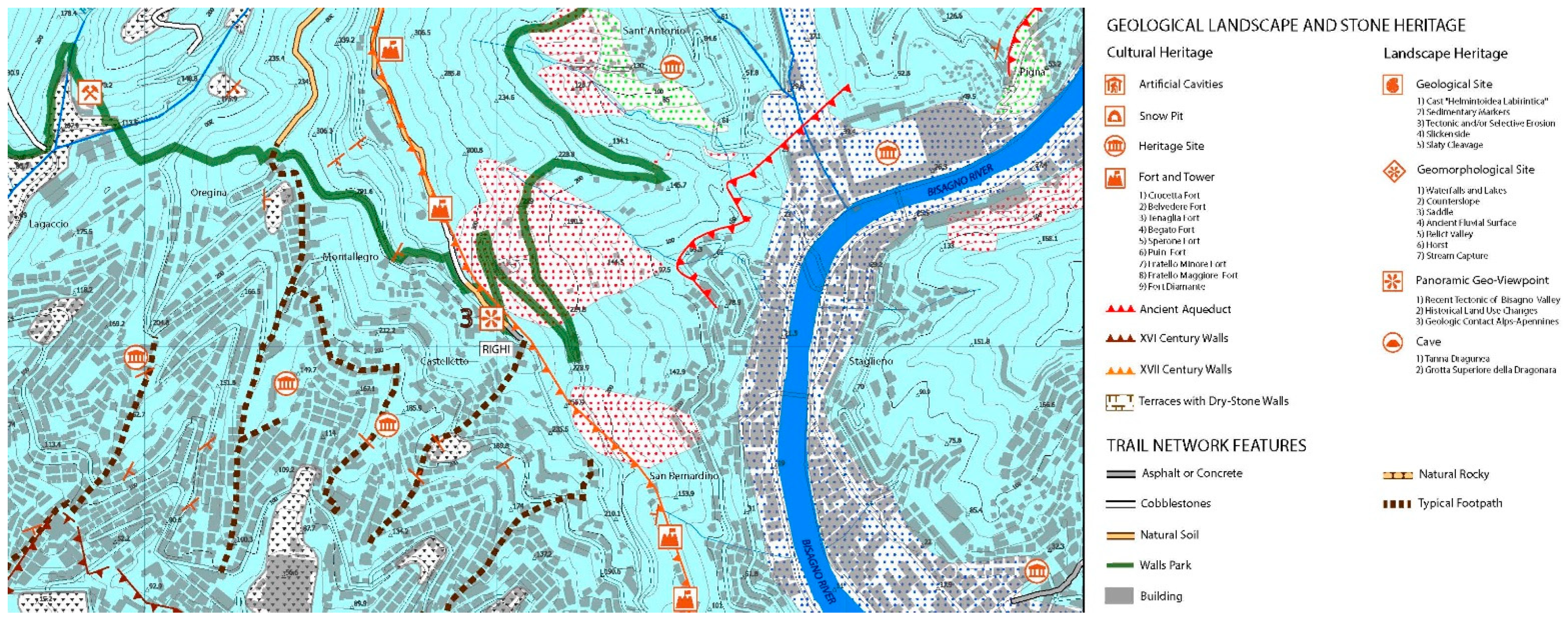
  42. Sacchini, A.; Ponaro, M.I.; Paliaga, G.; Piana, P.; Faccini, F.; Coratza, P. Geological landscape and stone heritage of the Genoa Walls Urban Park and surrounding area (Italy). J. Maps 2018, 14, 528–541. [Google Scholar] [CrossRef]
  43. Brandolini, F.; Cremaschi, M.; Pelfini, M. Correction to: Estimating the potential of archaeo-historical data in the definition of geomorphosites and geo-educational itineraries in the central po plain (N Italy). Geoheritage 2019, 11, 1397. [Google Scholar] [CrossRef] [Green Version]
  44. Aucelli, P.P.C.; Valente, E.; Di Paola, G.; Amato, V.; Cesarano, M.; Cozzolino, M.; Pappone, G.; Scorpio, V.; Rosskopf, C.M. The influence of the geological–geomorphological setting on human settlements and historical urban development: The case study of Isernia (southern Italy). J. Maps 2020, 17, 1–10. [Google Scholar] [CrossRef]
  45. Gioia, D.; Bavusi, M.; Di Leo, P.; Giammatteo, T.; Schiattarella, M. Geoarchaeology and geomorphology of the Metaponto area, Ionian coastal belt, Italy. J. Maps 2020, 16, 117–125. [Google Scholar] [CrossRef] [Green Version]
  46. Giardino, M.; Giordan, D.; Baggio, P.; Mortara, G. Map of the Sangonetto Valley Geosites (Western Alps): Geological research and tourism enhancement. In Mapping Geology in Italy; Pasquarè, G., Venturini, C., Eds.; APAT—Dipartimento di Difesa del Suolo, S.E.L.C.A.: Firenze, Italy, 2004; pp. 325–336. [Google Scholar]
  47. Castaldini, D.; Conventi, M.; Coratza, P.; Dallai, D.; Liberatoscioli, E.; Sala, L.; Buldrini, F. Carta Turistico—Ambientale della Riserva Naturale Regionale delle Salse di Nirano; Comune di Fiorano Modenese, Tipolitografia Notizie: Modena, Italy, 2011. [Google Scholar]
  48. Roberti, G.; McGregor, J.; Lam, S.; Bigelow, D.; Boyko, B.; Ahern, C.; Wang, V.; Barnhart, B.; Smyth, C.; Poole, D.; et al. Inspire standards as a framework for artificial intelligence applications: A landslide example. Nat. Hazards Earth Syst. Sci. 2020, 20, 3455–3483. [Google Scholar] [CrossRef]
  49. Panizza, M. Schema di legenda per carte geomorfologiche di dettaglio. Bollettino Società Geologica Italiana 1972, 91, 207–237. [Google Scholar]
  50. Pellegrini, G.B. Problemi di metodo per la costruzione di una carta geomorfologica a grande scala nel bacino dell’Alpago. In Atti e Memorie dell’Accademia Patavina di Scienze, Lettere e Arti, Classe di Scienze Matematiche e Naturali; Società Cooperativa Tipografica: Padova, Italy, 1976; Volume 88, pp. 43–51. [Google Scholar]
  51. Tricart, J. Géomorphologie et aménagement hydrauliques. L’Universitaire Sciences Techniques 1958, 1, 31–46. [Google Scholar]
  52. Demek, J. Generalization of geomorphological maps. IGU commission on applied geomorphology. In Geomorphological Mapping; Engineering Geology Special Publications: London, UK, 1967; pp. 36–72. [Google Scholar]
  53. Bashenina, N.V.; Gellert, J.F.; Joly, F.; Klimszewski, M.; Scholz, E. The unified key to the detailed geomorphological map. IGU commission on applied geomorphology. In Folia Geographica; Polska Academia Nauk: Warsaw, Poland, 1966; Volume 2, pp. 7–40. [Google Scholar]
  54. Klimaszewski, M. Problems of the detailed geomorphological map. In Folia Geographica, Series Geographica-Phisica; Polska Academia Nauk: Warsaw, Poland, 1968; Volume 2, p. 40. [Google Scholar]
  55. Joly, F.; Tricart, J. Légende Pour la Carte Géomorphologique de la France au 1:50.000; CNRS: Paris, France, 1970. [Google Scholar]
  56. Verstappen, H.T.H. Introduction to the ITC system of geomorphological survey. Koninlijk Nederlands Aardijkkundig Genootschap. Geogr. Niewe Reeks 1970, 4, 85–91. [Google Scholar]
  57. Gruppo Nazionale Geografia Fisica e Geomorfologia. Proposta di legenda geomorfologica a indirizzo applicativo. Geogr. Fis. Din. Quat. 1994, 16, 129–152. [Google Scholar]
  58. ISPRA. Carta Geomorfologica d’Italia 1:50.000—Guida alla Rappresentazione Cartografica. In Quaderni Serie III; 2007; Volume 10. Available online: https://www.isprambiente.gov.it/it/pubblicazioni/periodici-tecnici/i-quaderni-serie-iii-del-sgi/carta-geomorfologica-ditalia-1-50-000-guida-alla (accessed on 14 October 2021).
  59. Campobasso, C.; Carton, A.; Chelli, A.; D’Orefice, M.; Dramis, F.; Graciotti, R.; Guida, D.; Pambianchi, G.; Peduto, F.; Pellegrini, L. Aggiornamento ed Integrazioni delle Linee Guida della Carta Geomorfologica d’Italia alla Scala 1:50.000; ISPRA: Rome, Italy, 2018. Available online: https://www.isprambiente.gov.it/it/pubblicazioni/periodici-tecnici/i-quaderni-serie-iii-del-sgi/carta-geomorfologica-ditalia-alla-scala-1-50.000-aggiornamento-ed-integrazioni-delle-linee-guida-della-carta-geomorfologica-ditalia-alla-scala-1-50.000-fascicolo-i (accessed on 14 October 2021).
  60. Panizza, M. Geomorphosites: Concepts, methods and examples of geomorphological survey. Chin. Sci. Bull. 2001, 46, 4–5. [Google Scholar] [CrossRef]
  61. Reynard, E. Geosites. In Encyclopedia of Geomorphology; Goudie, A., Ed.; Routledge: London, UK, 2004; p. 440. [Google Scholar]
  62. Brocx, M. Geoheritage—from Global Perspectives to Local Principles for Conservation and Planning; Western Australian Museum: Perth, WA, Australia, 2008; p. 175. [Google Scholar]
  63. Nesci, O.; Valentini, L. Science, poetry, and music for landscapes of the Marche region, Italy: Communicating the conservation of natural heritage. Geosci. Commun. 2020, 3, 393–406. [Google Scholar] [CrossRef]
  64. Reynard, E.; Perret, A.; Bussard, J.; Grangier, L.; Martin, S. Integrated approach for the inventory and management of geomorphological heritage at the regional scale. Geoheritage 2016, 8, 43–60. [Google Scholar] [CrossRef]
  65. Reynard, E.; Brilha, J. Geoheritage: A multidisciplinary and applied research topic. In Geoheritage: Assessment, Protection and Management; Reynard, E., Brilha, J., Eds.; Elsevier: Amsterdam, The Netherlands, 2018; pp. 3–9. [Google Scholar]
  66. Coratza, P.; Hobléa, F. The specificities of geomorphological heritage. In Geoheritage: Assessment, Protection and Management; Reynard, E., Brilha, J., Eds.; Elsevier: Amsterdam, The Netherlands, 2018; pp. 87–106. [Google Scholar]
  67. Bollati, I.; Pellegrini, M.; Reynard, E.; Pelfini, M. Water driven processes and landforms evolution rates in mountain geomorphosites: Examples from Swiss Alps. Catena 2017, 158, 321–339. [Google Scholar] [CrossRef]
  68. Reynard, E.; Coratza, P. The importance of mountain geomorphosites for environmental education. Examples from the Italian Dolomites and the Swiss Alps. Acta Geogr. Slov. 2016, 56, 246–257. [Google Scholar] [CrossRef]
  69. Coratza, P.; Vandelli, V.; Fiorentini, L.; Paliaga, G.; Faccini, F. Bridging terrestrial and marine geoheritage: Assessing geosites in Portofino Natural Park (Italy). Water 2019, 11, 2112. [Google Scholar] [CrossRef] [Green Version]
  70. Bruschi, V.M.; Coratza, P.; Piacentini, D.; Soldati, M. Geomorphological features of the Rio della Rocca valley (northern Apennines, Italy). J. Maps 2012, 8, 445–452. [Google Scholar] [CrossRef]
  71. Pica, A.; Vergari, F.; Fredi, P.; Del Monte, M. The aeterna urbs geomorphological heritage (Rome, Italy). Geoheritage 2016, 8, 31–42. [Google Scholar] [CrossRef]
  72. Pica, A.; Luberti, G.M.; Vergari, F.; Fredi, P.; Del Monte, M. Contribution for an urban geomorphoheritage assessment method: Proposal from three geomorphosites in Rome (Italy). Quaest. Geogr. 2017, 36, 21–36. [Google Scholar] [CrossRef] [Green Version]
  73. Zgłobicki, W.; Poesen, J.; Cohen, M.; Del Monte, M.; García-Ruiz, J.M.; Ionita, I.; Niacsu, L.; Machová, Z.; Martín-Duque, J.F.; Nadal-Romero, E.; et al. The potential of permanent gullies in europe as geomorphosites. Geoheritage 2019, 11, 217–239. [Google Scholar] [CrossRef]
  74. Pelfini, M.; Bollati, I. Landforms and geomorphosites ongoing changes: Concepts and implications for geoheritage promotion. Quaest. Geogr. 2014, 33, 131–143. [Google Scholar] [CrossRef] [Green Version]
  75. García-Ortiz, E.; Fuertes-Gutiérrez, I.; Fernández-Martínez, E. Concepts and terminology for the risk of degradation of geological heritage sites: Fragility and natural vulnerability, a case study. Proc. Geol. Assoc. 2014, 125, 463–479. [Google Scholar] [CrossRef]
  76. Bruschi, V.M.; Coratza, P. Geoheritage and Environmental Impact Assessment (EIA). In Geoheritage: Assessment, Protection and Management; Reynard, E., Brilha, J., Eds.; Elsevier: Amsterdam, The Netherlands, 2018; pp. 251–264. [Google Scholar]
  77. Bollati, I.; Coratza, P.; Giardino, M.; Panizza, V.; Pelfini, M. I geomorfositi. In Aggiornamento ed Integrazioni delle Linee Guida della Carta Geomorfologica d’Italia alla Scala 1:50.000; Campobasso, C., Carton, A., Chelli, A., D’Orefice, M., Dramis, F., Graciotti, R., Guida, D., Pambianchi, G., Peduto, F., Pellegrini, L., Eds.; ISPRA: Roma, Italy, 2018; p. 15. [Google Scholar]
  78. Bollati, I.; Coratza, P.; Panizza, V.; Pelfini, M. Lithological and structural control on italian mountain geoheritage: Opportunities for tourism, outdoor and educational activities. Quaest. Geogr. 2018, 37, 53–73. [Google Scholar] [CrossRef] [Green Version]
  79. Coratza, P.; Marchetti, M.; Panizza, M. Itinerari Geologici-Geomorfologici in Alta Badia. N.1 Passo Gardena—Crespeina—Colfosco; Università degli Studi di Modena e Reggio Emilia, Consorzio Turistico Alta Badia: Modena, Italy, 2004. [Google Scholar]
  80. Faccini, F.; Roccati, A.; Firpo, M. Geo-hiking map of Mt. Penna and Mt. Aiona area (Aveto Natural Park, Italy). J. Maps 2012, 8, 293–303. [Google Scholar] [CrossRef] [Green Version]
  81. Pelfini, M.; Brandolini, P.; Carton, A.; Piccazzo, M.; Bozzoni, M.; Faccini, F.; Zucca, F. Rappresentazione in Carta delle Caratteristiche dei Sentieri ai Fini della Mitigazione del Rischio Geomorfologico. Boll. Assoc. Ital. Di Cartogr. 2006, Volume 126-127-128, 101–123. [Google Scholar]
  82. Ghiraldi, L. Geomatics Application for Evaluation and Exploitation of Geomorphosites in Piemonte Region. Ph.D. Thesis, University of Modena and Reggio Emilia, Modena, Italy, 2011; p. 206. [Google Scholar]
  83. Garavaglia, V.; Pelfini, M.; Bollati, I. The influence of climate change on glacier geomorphosites: The case of two italian glaciers investigated through dendrochronology—Influence du changement climatique sur la géodiversité: L’exemple de deux géomorphosites glaciales italiens enquêtés avec la dendrochronologie. Géomorphologie Relief Process. Environ. 2010, 2, 153–164. [Google Scholar]
  84. Bollati, I.; Leonelli, G.; Vezzola, L.; Pelfini, M. The role of ecological value in geomorphosite assessment for the debris-covered miage glacier (Western Italian Alps) based on a review of 2.5 centuries of scientific study. Geoheritage 2015, 7, 119–135. [Google Scholar] [CrossRef]
  85. Di Gregorio, F.; Forresu, R.; Frongia, P.; Piras, G. Carta dei Beni Naturali e culturali nel Paesaggio del Carignano del Sulcis. Bollettino dell’Associazione Italiana Cartografia 2013, 2282–2472X. (online). [Google Scholar]
  86. Reynard, E.; Fontana, G.; Kozlik, L.; Scapozza, C. A method for assessing “scientific” and “additional values” of geomorphosites. Geogr. Helv. 2007, 62, 148–158. [Google Scholar] [CrossRef]
  87. Reynard, E. Géomorphosites et paysages. Géomorphologie Relief Process. Environ. 2005, 3, 181–188. [Google Scholar] [CrossRef] [Green Version]
  88. Pelfini, M.; Brandolini, P.; Carton, A.; Piccazzo, M. Geotourist trails: A geomorphological risk-impact analysis. In Geomorphosites; Reynard, E., Coratza, P., Regolini-Bissig, G., Eds.; Pfeil Verlag: München, Germany, 2009; pp. 131–144. [Google Scholar]
  89. Coratza, P.; Ghinoi, A.; Piacentini, D.; Valdati, J. Management of geomorphosites in high tourist vocation area: An example of geo-hiking maps in the Alpe di Fanes (Natural Park of Fanes-Senes_Braies, Italian Dolomites). Geo J. Tour. Geosites 2008, 1, 106–117. [Google Scholar]
  90. Brandolini, P.; Pelfini, M. Mapping geomorphological hazard in relation to geotourism and hiking trails. In Mapping Geoheritage; Regolini-Bissing, G., Reynard, E., Eds.; Lausanne, Institut de Géographie, Géovision: Lausanne, Switzerland, 2010; pp. 31–45. [Google Scholar]
  91. Comănescu, L.; Nedelea, A.; Dobre, R. The geotouristic map—between theory and practical use. Case study—the central sector of the bucegi mountains (Romania). Geoj. Tour. Geosites 2013, 11, 16–23. [Google Scholar]
  92. Piana, F.; Fioraso, G.; Irace, A.; Mosca, P.; D’Atri, A.R.; Barale, L.; Falletti, P.; Monegato, G.; Morelli, M.; Tallone, S.; et al. Geology of Piemonte region (NW Italy, Alps-Apennines interference zone). J. Maps 2017, 13, 395–405. [Google Scholar] [CrossRef]
  93. Lombardo, V.; Piana, F.; Fioraso, G.; Irace, A.; Mimmo, D.; Mosca, P.; Tallone, S.; Barale, L.; Morelli, M.; Giardino, M. The classification scheme of the piemonte geological map and the ontogeonous initiative. Rendiconti Online della Società Geologica Italiana 2016, 39, 117–120. [Google Scholar] [CrossRef]
  94. Brilha, J.B. Inventory and quantitative assessment of geosites and geodiversity sites: A Review. Geoheritage 2016, 8, 119–134. [Google Scholar] [CrossRef] [Green Version]
  95. Brilha, J. Geoheritage: Inventories and evaluation. In Geoheritage: Assessment, Protection and Management; Reynard, E., Brilha, J., Eds.; Elsevier: Amsterdam, The Netherlands, 2018; pp. 87–106. [Google Scholar]
  96. Bruschi, V.M.; Cendrero, A.; Cuesta-Albertos, J.A. A statistical approach to the validation and optimisation of geoheritage assessment procedures. Geoheritage 2011, 3, 131–149. [Google Scholar] [CrossRef]
  97. Baadi, K.; Sabaoui, A.; Tekiout, B. Methodological proposal for assessment geosites: Its Application in Bou-Iblane Region (Middle Atlas, Morocco). Geoheritage 2020, 12, 55. [Google Scholar] [CrossRef]
  98. Reynard, E.; Coratza, P.; Regolini-Bissig, G. Scientific research on geomorphosites over the last eight years: Improvements and aims of the book. In Geomorphosites; Reynard, E., Coratza, P., Regolini-Bissig, G., Eds.; Pfeil Verlag: München, Germany, 2009; pp. 5–8. [Google Scholar]
  99. Grandgirard, V. Géomorphologie, Protection de la Nature et Gestion du Paysage. Ph.D. Thesis, Université de Fribourg, Fribourg, Switzerland, 1997. [Google Scholar]
  100. Grandgirard, V. L’évaluation des géotopes. Geol. Insubr. 1999, 4, 66–69. [Google Scholar]
  101. Pralong, J.P.; Reynard, E. A proposal for the classification of geomorphological sites depending on their tourist value. Il Quaternario 2005, 18, 315–321. [Google Scholar]
  102. Pelfini, M.; Gobbi, M. Enhancement of the ecological value of forni glacier as a possible new geomorphosite: New data from arthropods communities. Geog. Fis. Dinam. Quat. 2005, 28, 211–217. [Google Scholar]
  103. Pelfini, M.; Garavaglia, V.; Bollati, I. Dendrogeomorphological investigations for assessing ecological and educational value of glacier Geomorphosites. Two examples from the Italian Alps. In Mapping Geoheritage; Regolini-Bissing, G., Reynard, E., Eds.; Institut de Géographie: Lausanne, Switzerland, 2010; Volume 35, pp. 81–95. [Google Scholar]
  104. Reynard, E. Geomorphosites: Definition and characteristics. In Geomorphosites; Reynard, E., Coratza, P., Regolini-Bissig, G., Eds.; Pfeil Verlag: München, Germany, 2009; pp. 9–20. [Google Scholar]
  105. Regolini-Bissig, G. Cartographier les Géomorphosites. Objectifs, Publics et Propositions Méthodologiques. Ph.D. Thesis, University of Lausanne, Lausanne, Switzerland, 2012; 294p. [Google Scholar]
  106. Selmi, L.; Coratza, P.; Gauci, R.; Soldati, M. Geoheritage as a tool for environmental management: A case study in Northern Malta (Central Mediterranean Sea). Resources 2019, 8, 168. [Google Scholar] [CrossRef] [Green Version]
  107. Reynard, E. Geomorphosites and landscapes. In Geomorphosites; Reynard, E., Coratza, P., Regolini-Bissig, G., Eds.; Pfeil Verlag: München, Germany, 2009; pp. 21–34. [Google Scholar]
  108. Ferrando, A.; Faccini, F.; Poggi, F.; Coratza, P. Geosites inventory in Liguria region (Northern Italy): A tool for regional geoconservation and environmental management. Sustainability 2021, 13, 2346. [Google Scholar] [CrossRef]
  109. Reynard, E.; Panizza, M. Géomorphosites: Définition, évaluation et cartographie. Une introduction. Géomorphologie Relief Process. Environ. 2005, 11, 175–246. [Google Scholar] [CrossRef] [Green Version]
  110. Ghiraldi, L.; Giordano, E.; Perotti, L.; Giardino, M. Digital tools for collection, promotion and visualisation of geoscientific data: Case study of Seguret valley (Piemonte, NW Italy). Geoheritage 2014, 6, 103–112. [Google Scholar] [CrossRef]
  111. Pelfini, M.; Bollati, I.; Pellegrini, L.; Zucali, M. Earth sciences on the field: Educational applications for the comprehension of landscape evolution. Rendiconti Online Società Geologica Italiana 2016, 40, 56–66. [Google Scholar] [CrossRef] [Green Version]
  112. Pelfini, M.; Bollati, I.; Giudici, M.; Pedrazzini, T.; Sturani, M.; Zucali, M. Urban geoheritage as a resource for Earth Sciences education: Examples from Milan metropolitan area. Rendiconti Online Società Geologica Italiana 2018, 45, 83–88. [Google Scholar] [CrossRef]
  113. Hooke, I.M. Strategies for conserving and sustaining dynamic geomorphological sites. In Geological and Landscape Conservation; O’Halloran, D., Green, C., Harley, M., Stanley, M., Knill, J., Eds.; Geological Society of London Special Publications: London, UK, 1994; pp. 191–195. [Google Scholar]
  114. Strasser, A.; Heitzmann, P.; Jordan, P.; Stapfer, A.; Stürm, B.; Vogel, A.; Weidmann, M. Geotope und der Schutz erd-Wissenschaftlicher. Schweiz; Ein Strategiebericht: Fribourg, Switzerland, 1995. [Google Scholar]
  115. Koster, E.A. The “European aeolian sand belt: Geoconservation of drift sand landscapes”. Geoheritage 2009, 1, 93–110. [Google Scholar] [CrossRef] [Green Version]
  116. Coratza, P.; Parenti, C. Controlling factors of badland morphological changes in the Emilia Apennines (Northern Italy). Water 2021, 13, 539. [Google Scholar] [CrossRef]
  117. Reynard, E.; Hobléa, F.; Cayla, N.; Gauchon, C. Iconic sites for alpine geology and geomorphology. Rediscovering heritage? J. Alp. Res. 2011, 99-2. Available online: http://rga.revues.org/1435 (accessed on 14 October 2021).
  118. Ballantyne, C.K. Paraglacial geomorphology. Quat. Sci. Rev. 2002, 21, 1935–2017. [Google Scholar] [CrossRef]
  119. Wimbledon, W.A.P.; Andersen, S.; Cleal, C.J.; Cowie, J.W.; Erikstad, L.; Gonggrijp, G.P.; Johansson, C.E.; Karis, L.O.; Suominen, V. Geological world heritage: GEOSITES: A global comparative site inventory to enable prioritisation for conservation. Mem. Descrit. Carta Geol. Ital. 1999, 54, 45–60. [Google Scholar]
  120. Giusti, C.; Calvet, M. L’inventaire des géomorphosites en France et le problème de la complexité scalaire. Geomorphologie Relief Process. Environ. 2010, 2, 223–244. [Google Scholar] [CrossRef] [Green Version]
  121. Fuertes-Gutiérrez, I.; Fernández-Martínez, E. Geosites inventory in the Leon Province (Northern Spain): A tool to introduce geoheritage into regional environmental management. Geoheritage 2010, 2, 54–75. [Google Scholar] [CrossRef]
  122. Lapo, A.V.; Davydov, V.I.; Pashkevich, N.G.; Petrov, V.V.; Vdovets, M.S. Methodic principles of study of geological monuments of nature in Russia. Stratigr. Geol. Correl. 1993, I, 636–644. [Google Scholar]
  123. Ruban, D. Quantification of geodiversity and its loss. Proc. Geol. Assoc. 2010, 121, 326–333. [Google Scholar] [CrossRef]
  124. Brock, M.; Semeniuk, V. Geoheritage and geoconservation-history, definition, scope and scale. J. R. Soc. West. Aust. 2007, 90, 53–87. [Google Scholar]
  125. Tognetto, F.; Perotti, L.; Viani, C.; Colombo, N.; Giardino, M. Geomorphology and geosystem services of the Indren-Cimalegna area (Monte Rosa massif—Western Italian Alps). J. Maps 2021, 17, 161–172. [Google Scholar] [CrossRef]
  126. Cucchi, F.; Finocchiaro, F. Karst landforms in Friuli Venezia Giulia: From alpine to coastal karst. In Landscapes and landforms of Italy; Soldati, M., Marchetti, M., Eds.; Springer: Berlin/Heidelberg, Germany, 2017; pp. 147–156. [Google Scholar]
  127. Ponton, M. Note geologiche sulle Alpi Giulie occidentali. In Il Fenomeno Carsico nelle Alpi Giulie (Friuli); Muscio, G., Casagrande, G., Cucchi, F., Eds.; Mem. Ist. It. Speleologia: Bologna, Italy, 2011; Volume 24, pp. 58–80. [Google Scholar]
  128. Cucchi, F.; Finocchiaro, F.; Muscio, G. Geositi del Friuli Venezia Giulia; Università degli Studi di Trieste: Udine, Italy, 2010; p. 284. [Google Scholar]
  129. Casagrande, G.; Cucchi, F.; Manca, P.; Zini, L. L’idrostruttura del Monte Canin. In Il Fenomeno Carsico nelle Alpi Giulie (Friuli); Muscio, G., Casagrande, G., Cucchi, F., Eds.; Mem. Ist. It. Speleologia: Bologna, Italy, 2011; Volume 24, pp. 155–180. [Google Scholar]
  130. Steck, A. Tectonics of the Simplon massif and Lepontine gneiss dome: Deformation structures due to collision between the underthrusting European plate and the Adriatic indenter. Swiss J. Geosci. 2008, 101, 515–546. [Google Scholar] [CrossRef] [Green Version]
  131. Rigamonti, I.; Uggeri, A. L’evoluzione dell’Alpe Veglia nel quadro delle Alpe Centrali. Geol. Insubrica 2016, 1, 69–83. [Google Scholar]
  132. Curry, A.M. Paraglacial modification of slope form. Earth surface processes and landforms. J. Br. Geomorphol. Res. Group 1999, 24, 1213–1228. [Google Scholar]
  133. Cossart, E.; Fort, M. Sediment release and storage in early deglaciated areas: Towards an application of the exhaustion model from the case of Massif des Écrins (French Alps) since the Little Ice Age. Nor. Geogr. Tidsskr. Nor. J. Geogr. 2008, 62, 115–131. [Google Scholar] [CrossRef]
  134. Comitato Glaciologico Italiano. Campagna glaciologica 1995. Geogr. Fis. Din. Quat. 1995, 19, 147–184. [Google Scholar]
  135. Comitato Glaciologico Italiano. Itinerari Glaciologici sulle Montagne Italiane; Società Geologica Italiana: Bologna, Italy, 2018; Volume 3, pp. 215–234. [Google Scholar]
  136. Chiesa, S.; Fornero, I.; Frassoni, A.; Mazza, G.; Zanchi, A.; Zaninetti, A. Gravitational instability phenomena concerning a hydroelectric plant in Italy. In Proceedings of the 7 International Congress of Rock Mechanics, Aachen, Germany, 1 September 1991; pp. 6–7. [Google Scholar]
  137. Porter, S.C.; Orombelli, G. Glacier contraction during the middle Holocene in the western Italian Alps: Evidence and implications. Geology 1985, 13, 296. [Google Scholar] [CrossRef]
  138. Mezzena, F. La Valle d’Aosta nella preistoria e nella protostoria. In Archeologia in Valle d’Aosta; Catalogo Mostra: Aosta, Italy, 1981; pp. 14–62. [Google Scholar]
  139. Mezzena, F. Ricerche preistoriche e protostoriche in Valle d’Aosta. Revue d’Etudes Ligures Bordighera 1982, 41–42, 92–146. [Google Scholar]
  140. Mezzena, F.; Morandi, R. La Datazione delle Più Antiche Incisioni Rupestri Dell’Arco Alpino alla Luce dei Ritrovamenti di Vollein (Valle d’Aosta); Atti della XXVIII Riunione Scientifica su “L’arte in Italia dal Paleolitico all’Età del Bronzo”: Firenze, Italy, 1992; pp. 385–398. [Google Scholar]
  141. Giardino, M.; Martinotti, G.; Mezzena, F. Dinamica ambientale ed evoluzione del sito archeologico di Vollein, Media Valle d’Aosta. In GeoBen 2000 Proceedings: Condizionamenti Geologici e Geotecnici nella Conservazione del Patrimonio Storico Culturale; Lollino, G., Ed.; Gruppo Nazionale Difesa Catastrofi Idrogeologiche, CNR-IRPI-Torino: Torino, Italy, 2000; pp. 527–537. [Google Scholar]
  142. Deline, P.; Giardino, M.; Nicoud, G. Le Quaternaire des vallées alpines. In Fronts Glaciaires, Mouvements de Versant et Comblements Alluviaux Dans la Vallée de l’Arve et de l’Arve, d’Aoste et de Suse; Collection Edythem: Chambéry, Italy, 2005; p. 195. [Google Scholar]
  143. Martinotti, G.; Hunziker, J.C. The Austroalpine System in the Western Alps: A review. Mem. Soc. Geol. It. 1987, 29, 233–250. [Google Scholar]
  144. Mezzena, F. La Valle d’Aosta nel Neolitico e nell’Eneolitico. In Atti della XXXI Riunione Scientifica dell’Istituto Italiano di Preistoria e Protostoria. La Valle d’Aosta nel Quadro della Preistoria e Protostoria dell’Arco Alpino Centro-Occidentale, Courmayeur, 2–5 June 1994; Istituto Italiano di Preistoria e Protostoria: Florence, Italy, 1997; pp. 17–138. [Google Scholar]
  145. Skeates, R. Neolithic Italy at 4004 BC: People and places. Accord. Res. Pap. 2013, 13, 11425. [Google Scholar]
  146. Castiglioni, G.B.; Ajassa, R.; Baroni, C.; Biancotti, A.; Bondesan, A.; Bondesan, M.; Brancucci, G.; Castaldini, D.; Castellaccio, E.; Cavallin, A.; et al. Geomorphological Map of the Po Plain, 3 Sheets at 1:250,000 Scale; SELCA: Firenze, Italy, 1997. [Google Scholar]
  147. Pieri, M.; Groppi, G. Subsurface geological structure of the Po Plain, Italy. Prog. Final. Geod. Pubbl. 1991, 414, 1–3. [Google Scholar]
  148. Castaldini, D.; Marchetti, M.; Cardarelli, A. Geomorphological and archaeological aspects in the central Po Plain (Northern Italy). In Ol’man River. Geo-Archaeological Aspects of Rivers and River Plains; De Dapper, M., Vermeulen, F., Deprez, S., Taelman, D., Eds.; Universiteit Gent Academia Press: Gent, Belgium, 2009; pp. 193–211. [Google Scholar]
  149. Balista, C.; Calzolari, M.; Campagnoli, P.; Cardarelli, A.; Cattani, M.; Corazza, V.; Corti, C.; Gelichi, S.; Gianferrari, A.; Giordani, N.; et al. Atlante dei Beni Archeologici della Provincia di Modena; All’Insegna del Giglio: Florenze, Italy, 2003. [Google Scholar]
  150. Govi, M.; Turitto, O. Grandi inondazioni lungo il fiume Po negli ultimi 2 secoli: Scenari che si ripetono. In Proceedings of the International Conference La Prevenzione Delle Catastrofi Idrogeologiche: Il Contributo della Ricerca Scientifica, Alba, Italy, 5–7 November 1996; pp. 143–156. [Google Scholar]
  151. Luino, F. Le alluvioni storiche del fiume Po, in particolare dal 1861 a oggi. In L’Italia dei Disastri. Dati e Riflessioni Sull’Impatto Degli Eventi Naturali 1861–2013; Guidoboni, E., Valensise, G., Eds.; Bononia University Press: Bologna, Italy, 2013; pp. 109–157. [Google Scholar]
  152. Castaldini, D. Geomorfologia della bassa Pianura Padana modenese e dei territori limitrofi. In Mirandola e le Valli, Immagini e Documenti; Tip. Golinelli: Mirandola, Italy, 1989; pp. 25–37. [Google Scholar]
  153. Brandolini, P.; Faccini, F.; Robbiano, A.; Terranova, R. Geomorphological hazards and monitoring activity along the western rocky coast of the Portofino Promontory (Italy). Quat. Int. 2007, 171–172, 131–142. [Google Scholar] [CrossRef]
  154. Roccati, A.; Paliaga, G.; Luino, F.; Faccini, F.; Turconi, L. Rainfall Threshold for shallow landslides initiation and analysis of long-term rainfall trends in a Mediterranean area. Atmosphere 2020, 11, 1367. [Google Scholar] [CrossRef]
  155. Paliaga, G.; Luino, F.; Turconi, L.; De Graff, J.V.; Faccini, F. Terraced landscapes on portofino promontory (Italy): Identification, geo-hydrological hazard and management. Water 2020, 12, 435. [Google Scholar] [CrossRef] [Green Version]
  156. Turconi, L.; Faccini, F.; Marchese, A.; Paliaga, G.; Casazza, M.; Vojinovic, Z.; Luino, F. Implementation of nature-based solutions for hydro-meteorological risk reduction in small mediterranean catchments: The case of Portofino Natural Regional Park, Italy. Sustainability 2020, 12, 1240. [Google Scholar] [CrossRef] [Green Version]
  157. Ferrando, I.; Brandolini, P.; Federici, B.; Lucarelli, A.; Sguerso, D.; Morelli, D.; Corradi, N. Coastal modification in relation to sea storm effects: Application of 3D remote sensing survey in Sanremo Marina (Liguria, NW Italy). Water 2021, 13, 1040. [Google Scholar] [CrossRef]
  158. Brandolini, P.; Faccini, F.; Piccazzo, M. Geomorphological hazard and tourist vulnerability along Portofino Park trails (Italy). Nat. Hazard Earth Syst. Sci. 2006, 6, 563–571. [Google Scholar] [CrossRef] [Green Version]
  159. Faccini, F.; Robbiano, A.; Roccati, A.; Angelini, S. Engineering geological map of the Chiavari city area (Liguria, Italy). J. Maps 2012, 8, 41–47. [Google Scholar] [CrossRef]
  160. Nesci, O.; Valentini, L. TerreRare. Le Marche: Scienza, Poesia, Musica; Argalia: Urbino, Italy, 2019; p. 230. [Google Scholar]
  161. Valentini, L.; Nesci, O. A new approach to enhance the appeal of the Italian territory through art: Three study cases from Marche Region. Arab. J. Geosci. 2021, 14, 1–17. [Google Scholar] [CrossRef]
  162. Corazza, A.; Lombardi, L. Idrogeologia dell’area del centro storico di Roma. In La Geologia di Roma: Il Centro Storico; Memorie Descrittive della Carta Geologica d’Italia: Rome, Italy, 1995; Volume 50, pp. 179–211. [Google Scholar]
  163. Del Monte, M.; Fredi, P.; Pica, A.; Vergari, F. Geosites within Rome city center (Italy): A mixture of cultural and geomorphological heritage. Geogr. Fis. Din. Quat. 2013, 36, 241–257. [Google Scholar] [CrossRef]
  164. Del Monte, M.; D’Orefice, M.; Luberti, G.M.; Marini, R.; Pica, A.; Vergari, F. Geomorphological classification of urban landscapes: The case study of Rome (Italy). J. Maps 2016, 12, 178–189. [Google Scholar] [CrossRef] [Green Version]
  165. Ascani, F.; Bozzano, F.; Buccellato, A.; Del Monte, M.; Matteucci, R.; Vergari, F. Evoluzione del paesaggio e antiche vie di drenaggio nell’area de «IL Castellaccio» (Roma) da indagini geologiche, geomorfologiche e archeologiche. Geol. Romana 2008, 41, 93–116. [Google Scholar]
  166. Della Seta, M.; Del Monte, M.; Fredi, P.; Marra, F.; Pantani, G. Caratteri morfostrutturali del settore in riva destra del Fiume Tevere nell’area urbana di Roma. Geol. Romana 2002, 36, 105–122. [Google Scholar]
  167. Pica, A.; Reynard, E.; Grangier, L.; Kaiser, C.; Ghiraldi, L.; Perotti, L.; Del Monte, M. GeoGuides, urban geotourism offer powered by mobile application technology. Geoheritage 2017, 10, 311–326. [Google Scholar] [CrossRef]
  168. Clerici, E. Una Trivellazione Eseguita nel Tevere in Roma al Ponte Fabricio; Rendiconti Accademia Nazionale dei Lincei: Rome, Italy, 1911; pp. 922–926. [Google Scholar]
  169. Ventriglia, U. Geologia del Territorio del Comune di Roma; Amministrazione Provinciale di Roma: Roma, Italy, 2002. [Google Scholar]
  170. Vergari, F.; Luberti, G.M.; Pica, A.; Del Monte, M. Geomorphology of the historic centre of the Urbs (Rome, Italy). J. Maps 2020, 17, 1–12. [Google Scholar] [CrossRef]
  171. Pennetta, M.; Valente, A.; Abate, D.; Boudillon, G.; De Pippo, T.; Leone, M.; Terlizzi, F. Influenza della morfologia costiera sulla circolazione e sedimentazione sulla piattaforma continentale campano-laziale tra Gaeta e Cuma (Italia meridionale). Boll. Soc. Geol. It. 1998, 117, 281–295. [Google Scholar]
  172. Pennetta, M.; Brancato, V.M.; De Muro, S.; Gioia, D.; Kalb, C.; Stanislao, C.; Valente, A.; Donadio, C. Morpho-sedimentary features and sediment transport model of the submerged beach of the ‘Pineta della foce del Garigliano’ SCI Site (Caserta, southern Italy). J. Maps 2016, 12, 139–146. [Google Scholar] [CrossRef] [Green Version]
  173. Abate, D.; De Pippo, T.; Ilardi, M.; Pennetta, M. Studio delle caratteristiche morfoevolutive quaternarie della piana del Garigliano. Il Quat. 1998, 11, 149–158. [Google Scholar]
  174. Pennetta, M.; Corbelli, V.; Gattullo, V.; Nappi, R.; Brancato, V.M.; Gioia, D. Beach vulnerability assessment of a protected area of the Northern Campania coast (Southern Italy). J. Coast. Conserv. 2017, 22, 1017–1029. [Google Scholar] [CrossRef]
  175. Pennetta, M.; Stanislao, C.; D’Ambrosio, V.; Marchese, F.; Minopoli, C.; Trocciola, A.; Valente, R.; Donadio, C. Geomorphological features of the archaeological marine area of Sinuessa in Campania, southern Italy. Quat. Int. 2016, 425, 198–213. [Google Scholar] [CrossRef]
  176. Lambeck, K.; Anzidei, M.; Antonioli, F.; Benini, A.; Esposito, A. Sea level in Roman time in the Central Mediterranean and implications for recent change. Earth Planet. Sci. Lett. 2004, 224, 563–575. [Google Scholar] [CrossRef]
  177. Carmignani, L.; Oggiano, G.; Barca, S.; Conti, P.; Salvadori, I.; Eltrudis, A.; Funedda, A.; Pasci, S. Geologia della Sardegna. Note illustrative della Carta Geologica della Sardegna a scala 1:200 000. In Memorie Descrittive Carta Geologica d’Italia; Rome, Italy, 2001; p. 60. Available online: https://www.academia.edu/16956720/Geologia_della_Sardegna_Note_illustrative_Della_Carta_Geologica_in_Scala_1_200_000 (accessed on 23 August 2021).
  178. De Waele, J.; Pisano, M. Osservazioni geologiche, geomorfologiche ed idrogeologiche sul Supramonte di Baunei (Sardegna centro-orientale). Rend. Sem. Fac. Sci. Univ. Cagliari 1997, 67, 83–97. [Google Scholar]
  179. Dieni, I.; Massari, F. Mesozoic of Eastern Sardinia. In 19th European Micropaleontological Colloquium—Guide Book; AGIP: Cagliari, Italy, 1985; pp. 66–78. [Google Scholar]
  180. Massari, F.; Dieni, I. La Formazione fluvio-lacustre di Nuraghe Casteddu ed i suoi rapporti con i basalti di Orosei-Dorgali (Sardegna). Memorie Società Geologica Italiana 1973, 12, 377–410. [Google Scholar]
  181. Savelli, C.; Pasini, G.C. Preliminary results of K-Ar dating of basalts from Eastern Sardinia and the Gulf of Orosei. Giornale di Geologia 1973, 39, 303–312. [Google Scholar]
  182. De Waele, J. Geomorphologic evolution of a coastal karst: The gulf of Orosei (Central-East Sardinia, Italy). Acta Carsologica 2006, 33, 37–54. [Google Scholar] [CrossRef] [Green Version]
  183. Pasci, S. Tertiary transcurrent tectonics of NorthCentral Sardinia. Bull. De La Soc. Geol. Fr. 1997, 168, 301–312. [Google Scholar]
  184. Orrù, P.; Ulzega, A. Rilevamento geomorfologico costiero e sottomarino applicato alla definizione delle risorse ambientali (Golfo di Orosei, Sardegna orientale). Memorie Società Geologica Italiana 1987, 37, 471–479. [Google Scholar]
  185. Cossu, A.; De Waele, J.; Di Gregorio, F. Coastal karst geomorphosites at risk? A case study: The floods of 6–11 December 2004 in central-east Sardinia. Geol. Soc. Lond. Spec. Publ. 2007, 279, 85–95. [Google Scholar] [CrossRef]
  186. Carobene, L. Osservazioni sui solchi di battente attuali e antichi nel Golfo di Orosei in Sardegna. Boll. Soc. Geol. Ital. 1972, 91, 583–601. [Google Scholar]
  187. Carobene, L. Valutazione di movimenti recenti mediante ricerche morfologiche su falesie e grotte marine del Golfo di Orosei. Memorie Società Geologica Italiana 1978, 19, 641–649. [Google Scholar]
  188. Carobene, L.; Pasini, G.; Selli, R. Ancient coastlines in the Gulf of Orosei (western Sardinia). In Symposium sur la Géodynamique de la region Mediterraneenne; Commission Internationale pour l’Exploration Scientifique de la Mer Méditerranée: Paris, France, 1973. [Google Scholar]
  189. Carobene, L.; Pasini, G. Contributo alla conoscenza del Pleistocene superiore e dell’Olocene del Golfo di Orosei (Sardegna orientale). Bollettino Società Adriatica Scienze 1982, 64, 5–35. [Google Scholar]
  190. Antonioli, F.; Ferranti, L. Geomorfologia costiera e subacquea e considerazioni paleoclimatiche sul settore compreso tra Santa Maria Navarrese e Punta Golotitzé (Golfo di Orosei, Sardegna). Giornale Geologia 1992, 54, 66–89. [Google Scholar]
  191. Comănescu, L.; Nedelea, A.; Stănoiu, G. Geomorphosites and geotourism in Bucharest city center (Romania). Quaest. Geogr. 2017, 36, 51–61. [Google Scholar] [CrossRef] [Green Version]
  192. Zwoliński, Z.; Hildebrandt-Radke, I.; Mazurek, M.; Makohonienko, M. Anthropogeomorphological metamorphosis of an urban area in the postglacial landscape: A case study of Poznań city. Urban Geomorphol. 2018, 55–77. [Google Scholar] [CrossRef]
  193. Castaldini, D.; Valdati, J.; Ilies, D.C.; Chiriac, C. Geo-tourist map of the natural reserve of salse di nirano (Modena Apennines, Northern Italy). Ital. J. Quat. Sci. 2005, 18, 243–253. [Google Scholar]
  194. Ilieş, D.C.; Ilieş, A.; Herman, G.V.; Baias, Ş.; Morar, C. Geotourist Map of the Băile Felix—Băile 1 Mai-Betfia Area (Bihor County, Romania. GeoJournal Tour. Geosites 2011, 2, 219–226. [Google Scholar]
  195. Zwolinski, Z.; Stachowiak, J. Geodiversity map of the Tatra National Park for geotourism. Quaest. Geogr. 2012, 31, 99–107. [Google Scholar] [CrossRef] [Green Version]
  196. Badang, D.; Ali, C.A.; Komoo, I.; Leman, M.S. Sustainable geological heritage development approach in Sarawak Delta, Sarawak, Malaysia. Geoheritage 2016, 9, 443–462. [Google Scholar] [CrossRef]
  197. Cayla, N.; Hoblea, F.; Reynard, E. New digital technologies applied to the management of geoheritage. Geoheritage 2014, 6, 89–90. [Google Scholar] [CrossRef] [Green Version]
  198. Cayla, N.; Hoblea, F.; Guasquet, D. Place de la géomorphologie dans l’offre géotouristique de l’arc alpin: Du réel au virtuel. In Raising the Profile of Geomorphological Heritage Through Iconography, Inventory and Promotion; Giusti, C., Ed.; University Paris Sorbonne: Paris, France, 2012; pp. 65–71. [Google Scholar]
  199. Mariotto, F.P.; Bonali, F. Virtual geosites as innovative tools for geoheritage popularization: A case study from Eastern Iceland. Geosciences 2021, 11, 149. [Google Scholar] [CrossRef]
  200. Santos, I.D.O.; Henriques, R.; Mariano, G.; Pereira, D.I. Methodologies to represent and promote the geoheritage using unmanned aerial vehicles, multimedia technologies, and augmented reality. Geoheritage 2018, 10, 143–155. [Google Scholar] [CrossRef]
  201. Antoniou, V.; Nomikou, P.; Panousis, D.; Zafeirakopoulou, E. Nisyros Volcanic island: A geosite through a tailored GIS story. Geosciences 2021, 11, 132. [Google Scholar] [CrossRef]
  202. Gallerini, G.; Susini, S.; Bruciatelli, L.; De Donatis, M. Geomatics and geo-tourism: San Bartolo Natural Park case study (Pesaro, Italy). GeoActa Special Publication 2011, 3, 167–178. [Google Scholar]
  203. Martin, S.; Reynard, E.; Ondicol, R.P.; Ghiraldi, L. Multi-scale web mapping for geoheritage visualisation and promotion. Geoheritage 2014, 6, 141–148. [Google Scholar] [CrossRef]
  204. Mariotto, F.P.; Bonali, F.L.; Venturini, C. Iceland, an open-air museum for geoheritage and earth science communication purposes. Resources 2020, 9, 14. [Google Scholar] [CrossRef] [Green Version]
Figure 1. Location of the selected sites where the proposed legend and related symbols have been tested in the Italian context. The background images are courtesy of: Esri, DigitalGlobe, GeoEye, Earthstar. Geographics, CNES/Airbus DS, USDA, USGS, AeroGRID, IGN, and the GIS User Community (the whole Italy); Google Earth (1-3-4-5-6-7); Arpa Piemonte Geo3DViewer (2).
Sustainability 13 11538 g001
Figure 2. Examples of geotourism map for amateurs of Earth Sciences. (a) Excerpt from the leaflet of the geological-geomorphological itinerary in Val Badia (Dolomites, Italy) (modified after [79]). (b) Excerpt from the Geo-hiking Map of the Mt. Penna and Mt. Aiona area (Aveto Natural Park, Italy) (modified after [80]).
Sustainability 13 11538 g002
Figure 3. The geotourism map of the Tanaro valley (Piemonte, Italy) (modified after [82]).
Sustainability 13 11538 g003
Figure 4. Examples of map for specialists: (a) small-scale map showing the score of the numeric scientific evaluation (size of the circles) and the dominant additional values (circle’s shading) for each geomorphosite (modified after [86]); (b) simplified geomorphological map representing three areal-type geomorphosites of the Adamello-Brenta Nature Park (Italy) (modified after [1]); (c) simplified geomorphological map representing the geomorphological features of a complex geomorphosite (modified after [87]).
Sustainability 13 11538 g004
Figure 5. Excerpt from the map of Geological Landscape and Stone Heritage of the Genoa Walls Urban Park (modified after [42]) which combines elements of the geological, geomorphological and cultural landscape.
Sustainability 13 11538 g005
Figure 6. Examples of symbols to represent a geosite as a point according to their importance.
Sustainability 13 11538 g006
Figure 7. Examples of the graphical representation changes with the spatial scale.
Sustainability 13 11538 g007
Figure 8. Geomorphological map of the composite geosites of Mt. Canin (a); Canin glacieret, May 2012 (b); solution groove at Col delle Erbe plateau (c).
Sustainability 13 11538 g008
Figure 9. (a) Geomorphological map of the complex geomorphosite located along the Alpe Veglia Glaciological Itinerary, in the Lepontine Alps. The gold boundary in figure a includes the Aurona and Leone proglacial plains, glacial erosional and depositional landforms, permafrost-related landforms and landforms due to gravity- and water-related processes. Pictures report an example of the erosional processes affecting the Aurona LIA moraine (b); see location at the white star on (c), and a panoramic view on both the proglacial plains (photo courtesy of A. Pasinetti).
Sustainability 13 11538 g009
Figure 10. (a) Map and legend illustrating the Croce di Fana and Vollein complex geomorphosites (Central Aosta Valley, Western Italian Alps). (b) Large trench affecting glacially smoothed bedrock within the Croce di Fana large slope instability (c) Vollein whaleback ridge displaced by Deep-Seated Gravitational Slope Deformation; (d) Prehistoric rock carvings over the glacially smoothed bedrock at Vollein archeological site.
Sustainability 13 11538 g010
Figure 11. (a) Geomorphological map and location of the simple fluvial geosites: “Gavello fluvial ridge” in the northern sector of the maps, the Barchessoni palaoriver in the centre and the “Valle Le Partite” located between the meanders of “Barchessoni palaeoriver. Pictures represent the Barchessoni palaeoriver (b) and the Valle Le Partite area (c) from a frontal perspective.
Sustainability 13 11538 g011
Figure 12. (a) Geomorphological map and location of the Portofino Promontory geosite, a composite and areal geosite characterized by high conglomerate sea cliffs. (b,c) Panoramic views of the southern slope of Portofino Promontory between Punta Chiappa and Cala dell’Oro, showing active sea cliffs with heights that exceed 100 m a.s.l.; (d) San Fruttuoso hamlet bay surrounded by ancient dry-stone walls agricultural terraces, built just over the edge of conglomeratic sea cliff.
Sustainability 13 11538 g012
Figure 13. Geomorphological map of the Furlo Gorge complex geosite. The images represent panoramic views of the gorge.
Sustainability 13 11538 g013
Figure 14. (a) Geomorphological map of the Tiberina Island geosite. It is evidenced on the urban geomorphological map of Rome as it represents an urban geomorphosite of high cultural value inserted in a wider territory rich of geomorphological and cultural features. (b) Scheme showing the ancient confluence between Velabrum Maius and Tevere River. (c) Tiberina Island iconic image.
Sustainability 13 11538 g014
Figure 15. (a) Geomorphological map and location of the archaeological findings of the Sinuessa geosite; (b) location of the study area with reconstruction of the LGM drainage network. Pictures show several peculiar geomorphological and archaeological evidence of the area: (c) palaeo-sea notch at -7.5 m depth along the channel walls; (d) pebble beach (Roman age); (e) small depression located at a depth of about 8 m with several concrete blocks (pilae); (f) detail of a concrete block characterized by a man-made through-hole.
Sustainability 13 11538 g015
Figure 16. (a) Geomorphological map of the complex geomorphosite of Cala Luna. (b) View of sandy-pebbles beach and the littoral caves on carbonate cliff. (c) View from above of the Codu-la llune canyon. (d) Panoramic view of Cala Luna: cliff, backshore pond and beach. (e) Relic tidal notch and the Cala Luna cliff in the background.
Sustainability 13 11538 g016
Table 1. Geosites categories based on their geometrical and genetic characters and their scientific relevance.
FEATURECategoryDefinitionExamples
A. Geometry—The shifting between the above categories (e.g., from point to polygon or vice versa) is regulated by the scale of the map.pointsmall-size isolated single landform or objecta pothole
an erratic boulder
polylineone or more single landforms aligned in a preferred directiona canyon
a paleo riverbed
polygona set of single landforms within a large areaa set of ridges forming a morainic amphitheatre
B. Genesissimpleunique landform related to one dominant genetic processkarren field
compositegroup of landforms related to one dominant genetic processkarren field with karrens and sinkholes
complexgroup of landforms related to more than one dominant genetic process (eventually interlinked by a network of genetic and functional relationship)proglacial areas where glacial, slope- and water-related processes interact
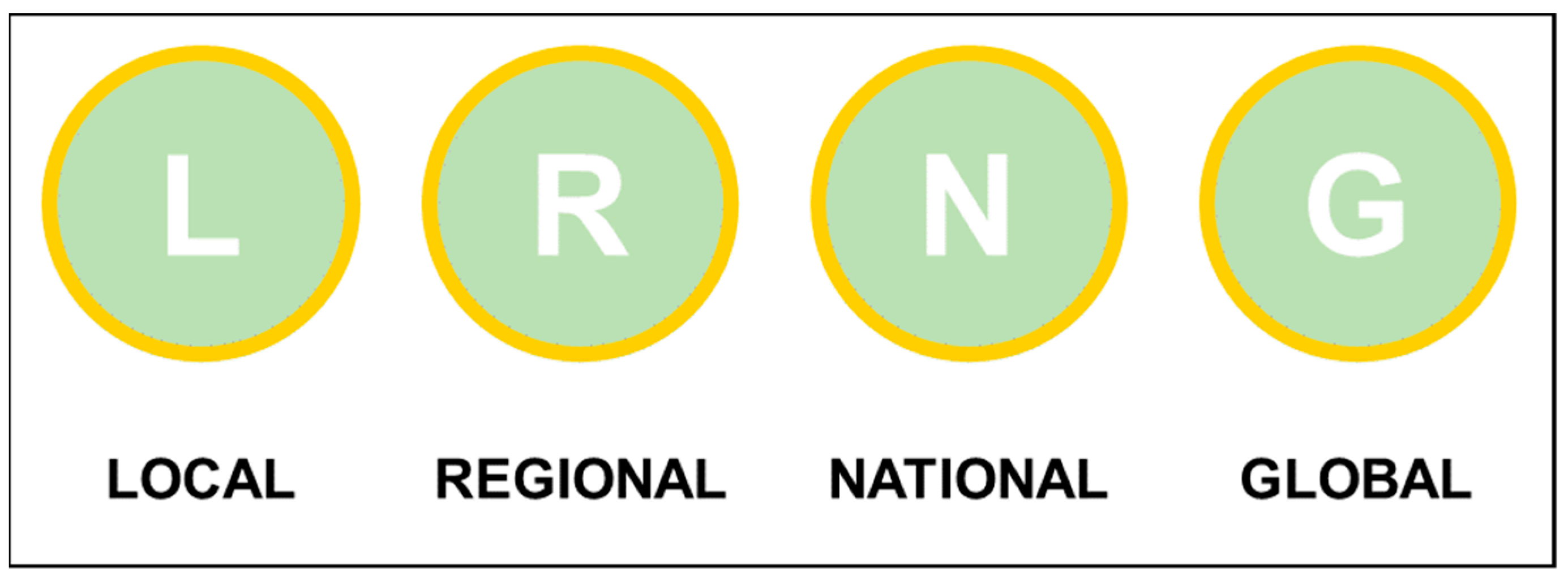
C. Scientific and territorial importancelocalimportance for a single municipal territories and districts
regionalimportance for larger territorial body within a country
nationalimportance for a whole country
globalimportance at the international level
Table 2. The colours of the genetic processes used for the circle filling in accordance with the Italian scale of colours of the geomorphologic legend.
LandformsColour
Litho-structural landformsmustard
Tectonic landformsdark brown
Vulcanic landformsbrown
Gravity-induced landformsred
Fluvial, glacio-fluvial and due to running water landformsgreen
Karstic landformsorange
Glacial landformspurple
Periglacial landformsblue
Coastal landformslight blue
Aeolian landformsyellow
Anthropic landformsblack
Table 3. Main features of the selected sites where the proposed legend has been tested.
NName of the
Geomorphosite
Main Morphogenetic ProcessesTypological
Category
Scale Related
Representation
Importance
1:25,0001:50,000
01Mount CaninKarstic, glacial, hydrologicalComposite, Simple,Polygon and PointPolygon and PointGlobal, National, Local
02Proglacial systems of the Aurona and Leone GlaciersParaglacial and periglacialComplexPolygonPolygonLocal
03Croce di FanaGravitational, glacialComplexPolygon and PointPolygon and PointRegional, Global
04Fluvial landscape in central Po PlainFluvialSimplePolygonPolygonRegional, local
05High rocky cliffs in the Portofino PromontoryMarine, gravitational, running waterCompositePolygonPolylineGlobal
06Furlo GorgeFluvial, gravitationalComplexPolygonPolygonNational
07Tiberina IslandFluvial, anthropogenicSimplePolygonPointRegional
08Sinuessa submerged landscape in the Gaeta BayMarine, coastal, fluvialComplexPolygonPolygonRegional
09Fluvio-coastal system of Cala LunaFluvial, coastal, karsticComplexPolygonPolygonGlobal
Publisher’s Note: MDPI stays neutral with regard to jurisdictional claims in published maps and institutional affiliations.

