
Evaluation of the Visitor Understanding of Coastal Geotourism and Geoheritage Potential Based on Sustainable Regional Development in Western Black Sea Region, Turkey

 , , , and
Abstract
:1. Introduction
1.1. Geoheritage and Geotourism in Turkey
1.2. Research Background and Aims
2. Conceptual Framework and Research Questions
- (i)
- What are the perceptions and understandings of the visitors regarding geodiversity, geoconservation and geoheritage?
- (ii)
- What should be conducted to improve the visitor experience during a field visit?
- (iii)
- What is the relationship between geodiversity and other touristic and recreational activities in terms of visitor experience?
- (iv)
- How will diversification of tourism in the study area contribute to sustainable local development?
3. Study Area
4. Methods
- Determining the socio-demographic structure of the visitors;
- Determining the perception and understanding of the visitors regarding the concepts of “Geological diversity”, “Geoheritage” and “Geoconservation”;
- Identifying awareness of the natural and cultural characteristics of Güzelcehisar;
- Determining the opinions and ideas about the geological features of the GBCs;
- Determining the criteria affecting the visit of the site and measuring the understanding of the adequacy of the information about the geological features of the site;
- Identifying what needs to be conducted to improve visitor experiences during site visits;
- Revealing the relationship of geodiversity with other touristic and recreational activities based on visitor experience;
- Integrating the understanding of geological heritage into tourism (geoheritage understanding engagement with tourism);
- After the visitor experience, it was aimed to obtain on-site interpretations and ideas about the memorable image of the area and the protection of geological features.
5. Results
5.1. SWOT
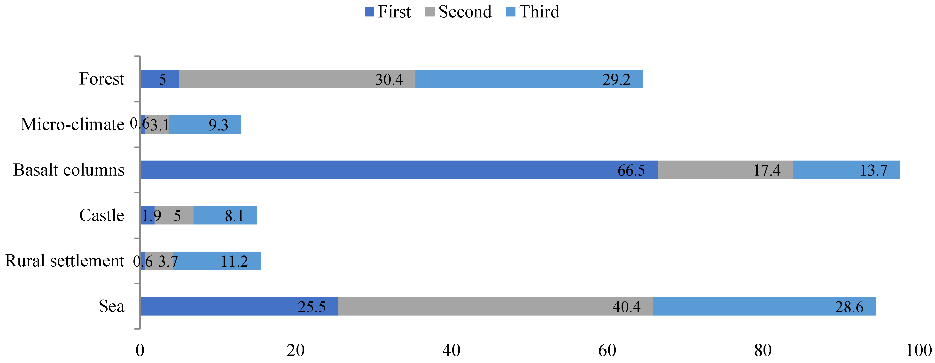
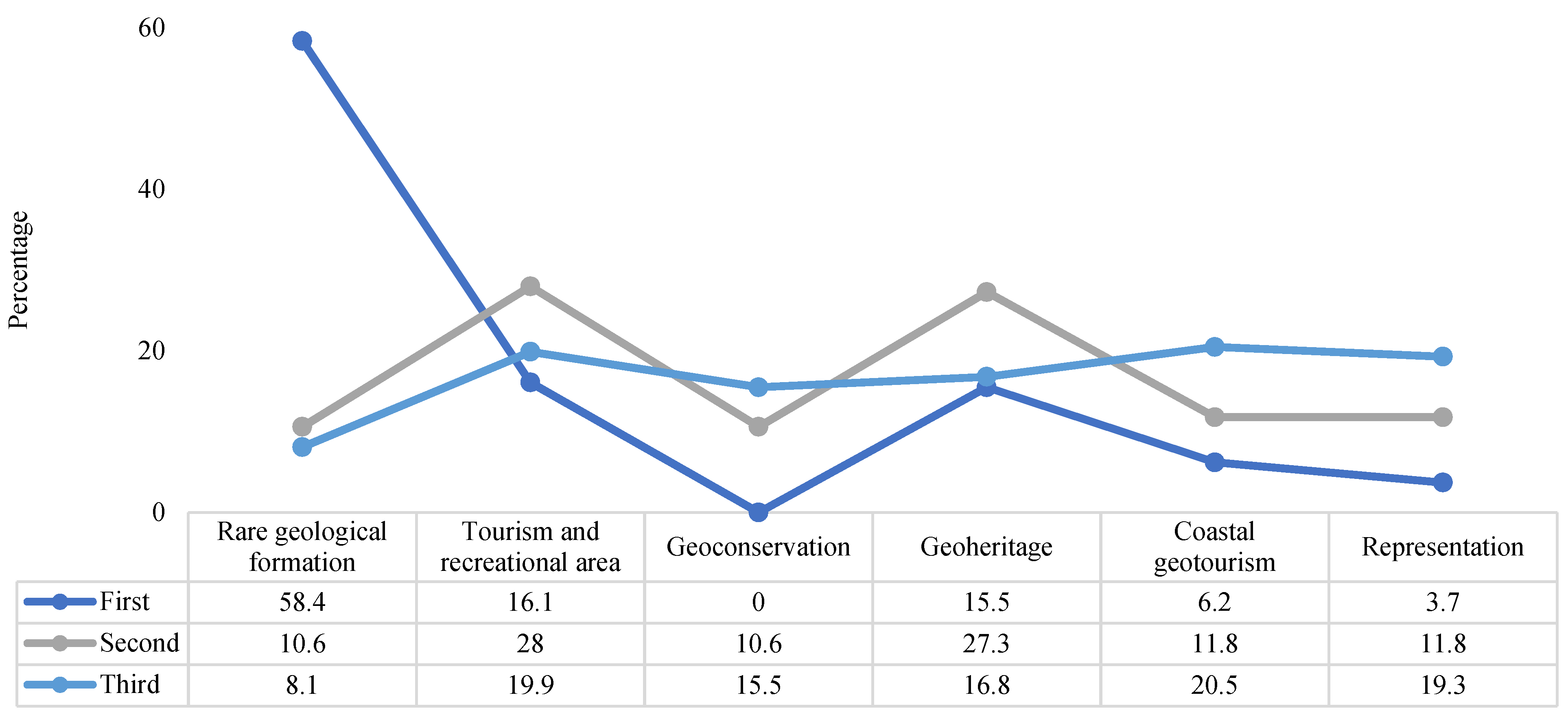
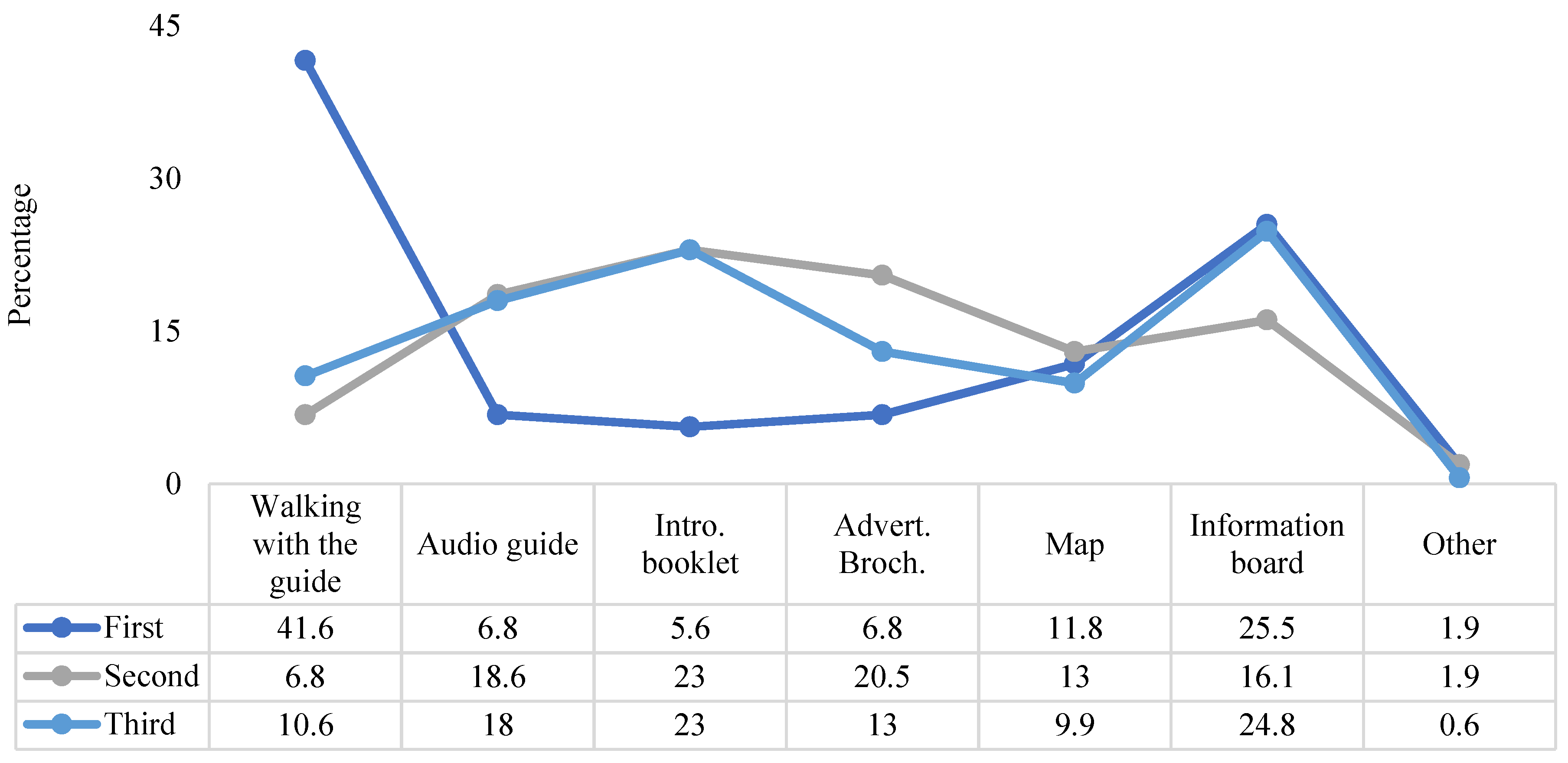
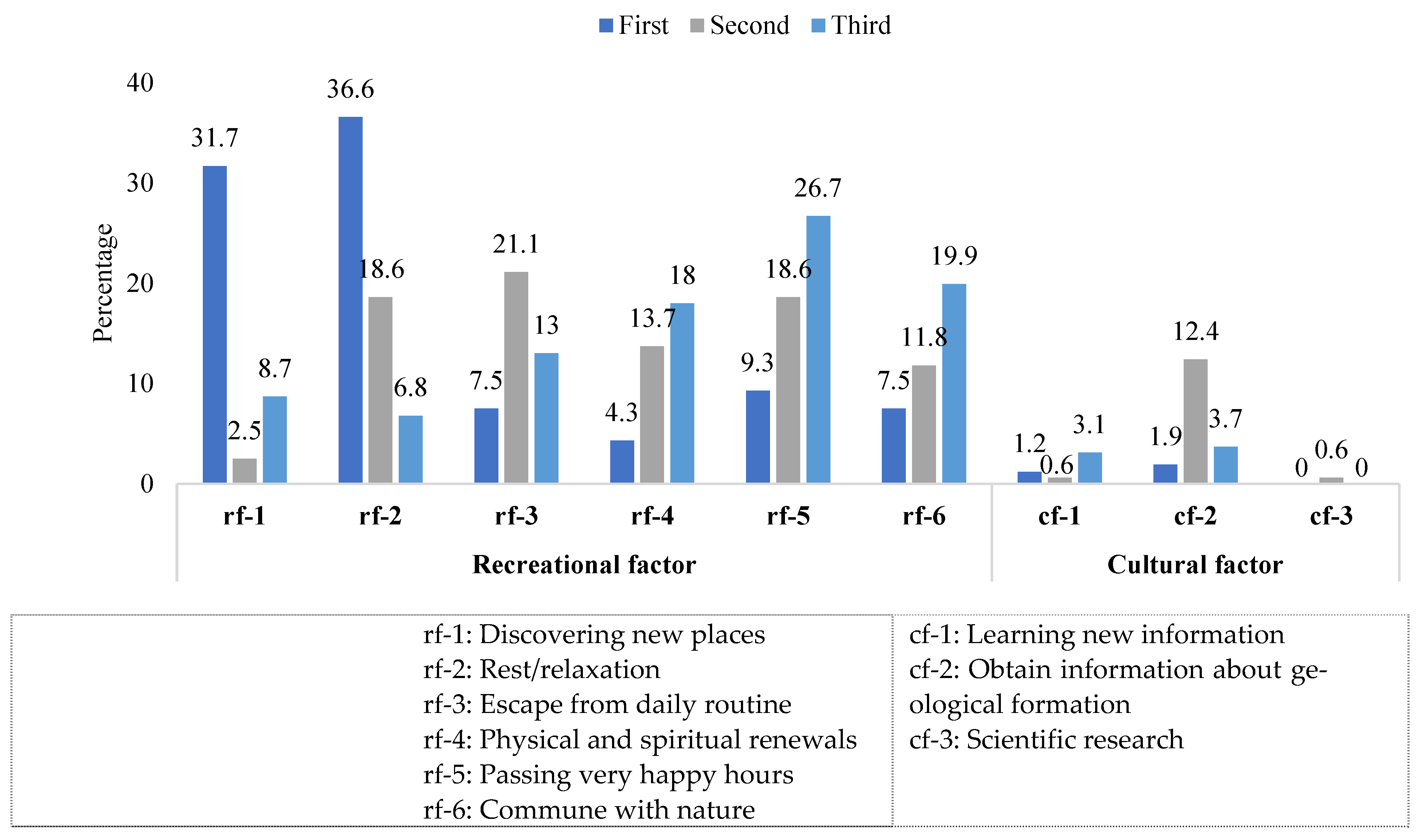
5.2. Survey Results
5.3. Chi-square Test Results
6. Discussion and Conclusion
6.1. Theoretical Implications
6.2. Managerial Implications
6.3. Limitations and Future Research Directions
6.4. Conclusions
Author Contributions
Funding
Institutional Review Board Statement
Informed Consent Statement
Data Availability Statement
Conflicts of Interest
References
- Ólafsdóttir, R.; Tverijonaite, E. Geotourism: A systematic literature review. Geosciences 2018, 8, 234. [Google Scholar] [CrossRef] [Green Version]
- Santos, D.S.; Mansur, K.L.; Seoane, J.C.S.; Mucivuna, V.C.; Reynard, E. Methodological proposal for the inventory and assessment of geomorphosites: An integrated approach focused on terriorial management geoconservation. Environ. Manag. 2020, 66, 476–497. [Google Scholar] [CrossRef] [PubMed]
- Hose, T. Selling the story of Britain’s stone. Environ. Interpret. 1995, 10, 16–17. [Google Scholar]
- Newsome, D.; Dowling, R. Setting an agenda for geotourism. In Geotourism: The Tourism of Geology and Landscape; Newsome, D., Dowling, R., Eds.; Goodfellow Publishers Ltd.: Oxford, UK, 2010; pp. 1–12. [Google Scholar]
- Burlando, M.; Firpo, M.; Queirolo, C.; Rovere, A.; Vacchi, M. From geoheritage to sustainable development: Strategies and perspectives in the Beigua geopark (Italy). Geoheritage 2011, 3, 63–72. [Google Scholar] [CrossRef]
- Erikstad, L. Geoheritage and geodiversity management–the questions for tomorrow. Proc. Geol. Assoc. 2013, 124, 713–719. [Google Scholar] [CrossRef]
- Crawford, K.R.; Black, R. Visitor Understanding of the Geodiversity and the Geoconservation Value of the Giant’s Causeway World Heritage Site, Northern Ireland. Geoheritage 2012, 4, 115–126. [Google Scholar] [CrossRef]
- Brocx, M.; Semeniuk, V. Geoheritage and geoconservation. History, definition, scope and scale. J. R. Soc. West. Aust. 2007, 90, 53–87. [Google Scholar]
- Bentivenga, M.; Cavalcante, F.; Mastronuzzi, G.; Palladino, G.; Prosser, G. Geoheritage: The foundation for sustainable geotourism. Geoheritage 2019, 11, 1367–1369. [Google Scholar] [CrossRef] [Green Version]
- Štrba, L.; Kršák, B.; Sidor, C. Some comments to geosite assessment, visitors, and geotourism sustainability. Sustainability 2018, 10, 2589. [Google Scholar] [CrossRef] [Green Version]
- Brilha, J. Inventory and quantitative assessment of geosites and geodiversity sites: A review. Geoheritage 2016, 8, 119–134. [Google Scholar] [CrossRef] [Green Version]
- Esik, Z.; Rozsa, P.; Szepesi, J. Geoheritage elements of millstone manufactory, Tokaj Mountains, Hungary. J. Eur. Fed. Geol. 2019, 48, 38–42. [Google Scholar]
- Reynard, E. Geosite. In Encyclopedia of Geomorphology; Goudie, A.S., Ed.; Routledge: London, UK, 2014; Volume 1. [Google Scholar]
- Geremia, F.; Bentivenga, M.; Palladino, G. Environmental geology applied to geoconservation in the interaction between geosites and linear infrastructures in south-eastern Italy. Geoheritage 2015, 7, 33–46. [Google Scholar]
- Stanley, M. Geodiversity. Earth Herit. 2000, 14, 15–19. [Google Scholar]
- Burek, C.V.; Prosser, C.D. The history of geoconservation: An 3introduction. Geol. Soc. Lond. Spec. Publ. 2008, 300, 1–5. [Google Scholar] [CrossRef] [Green Version]
- Lazzari, M.; Aloia, A. Geoparks, geoheritage and geotourism: Opportunities and tools ın sustainable development of the territory. Geoj. Tour. Geosites 2014, 1, 8–9. [Google Scholar]
- Tavares, A.O.; Henriques, M.H.; Domingos, A.; Bala, A. Community Involvement in Geoconservation: A Conceptual Approach Based on the Geoheritage of South Angola. Sustainability 2015, 7, 4893–4918. [Google Scholar] [CrossRef] [Green Version]
- Gordon, E.J. Geoheritage, geotourism and the cultural landscape: Enhancing the visitor experience and promoting geoconservation. Geosciences 2018, 8, 136. [Google Scholar] [CrossRef] [Green Version]
- Du Preez, E.A. The contribution of geological features to visitor experiences: Comparison between two geotourism attractions in South Africa. Geoj. Tour. Geosites 2019, 26, 874–888. [Google Scholar] [CrossRef]
- Gray, M. Geodiversity: Valuing and Conserving Abiotic Nature; Wiley: Hoboken, NJ, USA, 2004. [Google Scholar]
- Pourfaraj, A.; Haderi, E.; Jomehpour, M.; Ferdowsi, S. Conservation management of geotourism attractions in tourism destinations. Geoheritage 2020, 12, 80. [Google Scholar] [CrossRef]
- Keskin Citiroglu, H.; Isik, S.; Pulat, O. Utilizing the geological diversity for sustainable regional development, a case study-Zonguldak. Geoheritage 2017, 9, 211–223. [Google Scholar] [CrossRef]
- Cai, Y.; Wu, F.; Han, J.; Chu, H. Geoheritage and sustainable development in Yimengshan Geopark. Geoheritage 2019, 11, 991–1003. [Google Scholar] [CrossRef]
- Dowling, R.K. Geotourism’s global growth. Geoheritage 2011, 3, 1–13. [Google Scholar] [CrossRef]
- Garofano, M. Geowatching, a term for the popularisation of geological heritage. Geoheritage 2015, 7, 25–32. [Google Scholar] [CrossRef]
- Köroğlu, F.; Kandemir, R. Vulnerable geosites of Çayırbağı-Çalköy (Düzköy-Trabzon) in the Eastern Black Sea Region of NE Turkey and their geotourism potential. Geoheritage 2019, 11, 1101–1111. [Google Scholar] [CrossRef]
- Suyanto, A.; Haryono, E.; Baiquni, M. Visitors satisfaction Monitoring Using Important Perform Analysis in Pindul Geoheritage-Indonesia. IOP Conf. Ser. Earth Environ. Sci. 2020, 451, 012043. [Google Scholar] [CrossRef]
- Brilha, J.; Gray, M.; Pereira, D.I.; Pereira, P. Geodiversity: An integrative review as a contribution to the sustainable management of the whole of nature. Environ. Sci. Policy 2018, 86, 19–28. [Google Scholar] [CrossRef] [Green Version]
- Yeşil, P.; Yeşil, M.; Yılmaz, H. Jeolojik miras alanlarının alternatif turizm kapsamında değerlendirilmesi: Ballıca Mağarası örneği. Atatürk Üniv. Ziraat Fak. Derg. 2008, 39, 241–248. [Google Scholar]
- Çelik Ateş, H.; Ateş, Y. Geotourism and Rural Tourism Synergy for Sustainable Development-Maçka Valley Case-Tunceli, Turkey. Geoheritage 2019, 11, 207–215. [Google Scholar] [CrossRef]
- Demir, T.; Aytaç, A.S. Kula UNESCO Global Jeoparkı: Türkiye’nin UNESCO tescilli ilk ve tek global jeoparkı. Kula UNESCO Global Geopark: Turkey’s first and only global geopark registered by UNESCO. TÜCAUM 30. In Proceedings of the Yıl Uluslararası Coğrafya Sempozyumu International Geography Symposium on the 30th Anniversary of TUCAUM 3-6 Ekim 2018, Ankara, Turkey, 3–6 October 2018. [Google Scholar]
- Özgeriş, M.; Karahan, F. Use of geopark resource values for a sustainable tourism: A case study from Turkey (Cittaslow Uzundere). Environ. Dev. Sustain. 2021, 23, 4270–4284. [Google Scholar] [CrossRef]
- Ertekin, C.; Ekinci, Y.L.; Büyüksaraç, A.; Ekinci, R. Geoheritage in mythical and volcanic terrain: An inventory and assessment study for geopark and geotourism, Nemrut Volcano (Bitlis, Eastern Turkey). Geoheritage 2021, 13, 73. [Google Scholar] [CrossRef]
- Kazancı, N.; Suludere, Y.; Boyraz, S.; Ulaş, D.; Sayılı, S.; Mülazımoğlu, N.S.; Eker, M.; Şahin, Ş.; Yedek, Ö.; Yücel, O.T.; et al. Jeolojik Koruma ve Jeopark Eğitimi; Proje Uygulaması. 64. Türkiye Jeoloji Kurultayı (25–29 Nisan 2011) Bildiri Özetleri Kitabı, Jeoloji Mühendisleri Odası, 2011a. Ankara, Türkiye. s. 321–322. Available online: https://www.jmo.org.tr/resimler/ekler/912a88e8d88e44a_ek.pdf (accessed on 20 October 2021).
- Kazancı, N.; Suludere, Y.; Mülazımoğlu, N.S.; Tuzcu, S.; Turgut, A.; Ulaş, D.; Şahin, Ş.; Yüce, C.; Eker, M. Kızılcahamam (Ankara) Bölgesinde Uygulamalı Jeolojik Miras, Jeopark ve Jeoturizm Eğitimi TÜBİTAK Projesi. 2011b. Proje No: No 110B041, Sonuç Raporu, 21 s., Ankara, Türkiye. Available online: https://dergipark.org.tr/tr/download/article-file/89123 (accessed on 20 October 2021).
- Kazancı, N. Geological background and three vulnerable geosites of the Kızılcahamam–Çamlıdere geopark project in Ankara, Turkey. Geoheritage 2012, 4, 249–261. [Google Scholar] [CrossRef]
- Cengiz, C.; Cengiz, B.; Bekçi, B.; Tekdamar, D. Bartın Güzelcehisar Kıyı Yerleşiminin Ekolojik Planlaması. Bartın Üniversitesi Bilimsel Araştırma Projesi, 2015. Proje No: BAP-2011-2-26, Bartın, Türkiye. Available online: https://peyzaj.bartin.edu.tr/arastirma/bap-projeleri.html (accessed on 20 October 2021).
- Cengiz, C.; Cengiz, B. The Güzelcehisar-Bartın Coastal Landscape Heritage Project. In Proceedings of the International Conference on Sustainable Development, ICSD 2016, Skopje, Macedonia, 19–23 October 2016; pp. 411–419. [Google Scholar]
- Cengiz, B.; Cengiz, C.; Karakoç, H. Bartın İli Güzelcehisar Lav Sütunları ve Sahilinin Turizm ve Rekreasyon Amaçlı Peyzaj Uygulama Projesi. 2018. BAKKA 2016 Yılı Küçük Ölçekli Altyapı Mali Destek Programı TR81/16/KÖA/0042 Kodlu Proje Çıktısı, 80 sf., Bartın, Türkiye. Available online: https://www.bakkakutuphane.org/dokuman/bartin-ili-guzelcehisar-lav-sutunlari-ve-sahilinin-turizm-ve-rekreasyon-amacli-peyzaj-uygulama-projesi/409 (accessed on 20 October 2021).
- Cengiz, B.; Yakan, O.E. Kırsal Peyzajların Sürdürülebilir Gelişimi Bağlamında Kıyısal Alanlarda Görsel Peyzaj Değerlendirmesi: Güzelcehisar Köyü Örneği. Bartın Üniversitesi. Bilimsel Araştırma Projesi, 2019. Proje No: 2018- FEN-CY-009. Bartın, Türkiye. Available online: file:///C:/Users/MDPI/AppData/Local/Temp/O%C4%9Fuz%20Erdi%20pdf.pdf (accessed on 20 October 2021).
- UNWTO 2021. The World Tourism Organization. Available online: https://www.unwto.org/ (accessed on 20 October 2021).
- López-Sanz, J.M.; Penelas-Leguía, A.; Gutiérrez Rodríguez, P.; Cuesta-Valiño, P. Sustainable development and consumer behavior in rural tourism—the importance of image and loyalty for host communities. Sustainability 2021, 13, 4763. [Google Scholar] [CrossRef]
- Baixinho, A.; Santos, C.; Couto, G.; de Albergaria, I.S.; da Silva, L.S.; Medeiros, P.D.; Neves, R.M. Creative tourism on islands: A review of the literature. Sustainability 2020, 12, 10313. [Google Scholar] [CrossRef]
- Cuesta-Valiño, P.; Bolifa, F.; Núñez-Barriopedr, E. Sustainable, smart and Muslim-friendly tourist destinations. Sustainability 2020, 12, 1778. [Google Scholar] [CrossRef] [Green Version]
- Moreno, L.; Ramón, A.; Such, M.J. The challenge of long-term tourism competitiveness in the age of innovation: Spain as a case of study. J. Reg. Res. Investig. Reg. 2018, 42, 13–34. [Google Scholar]
- López-Sanz, J.M.; Penelas-Leguía, A.; Gutiérrez-Rodríguez, P.; Cuesta-Valiño, P. Sustainable development and rural tourism in depopulated areas. Land 2021, 10, 985. [Google Scholar] [CrossRef]
- Gretzel, U. From smart destinations to smart tourism regions. J. Reg. Res. Investig. Reg. 2018, 42, 171–184. [Google Scholar]
- López-Sanz, J.M.; Penelas-Leguía, A.; Gutiérrez-Rodríguez, P.; Cuesta-Valiño, P. Rural tourism and the sustainable development goals. a study of the variables that most influence the behavior of the tourist. Front. Psychol. 2021, 12, 722973. [Google Scholar] [CrossRef]
- Puška, A.; Pamucar, D.; Stojanovi’c, I.; Cavallaro, F.; Kaklauskas, A.; Mardani, A. Examination of the sustainable rural tourism potential of the Brcko district of Bosnia and Herzegovina using a fuzzy approach based on group decision making. Sustainability 2021, 13, 583. [Google Scholar] [CrossRef]
- Hence, B.G.; Salvaj, E.; Cuesta-Valino, P. A Sustainable management model for cultural creative tourism ecosystems. Sustainability 2020, 12, 9554. [Google Scholar]
- Cristobal-Fransi, E.; Daries, N.; Ferrer-Rosell, B.; Marine-Roig, E.; Martin-Fuentes, E. Sustainable tourism marketing. Sustainability 2020, 12, 1865. [Google Scholar] [CrossRef] [Green Version]
- Anonymous. Güzelcehisar Village Culture and Tourism Inventory; Bartın Provincial Directorate of Culture and Tourism Archive: Bartın, Turkey, 2012. [Google Scholar]
- Anonymous. Bartın Güzelcehisar First Degree Archaeological Site Conservation Plan 1/5000 Scale Master and 1/1000 Scale Implementation Development Plan Research and Plan Description Report; Bartın Special Provincial Administration: Bartın, Turkey, 2011. [Google Scholar]
- Tokay, M. Geologie De La Region De Bartın. Bull. Miner. Res. Explor. 1955, 46. [Google Scholar]
- Chauhan, G.; Baiswas, S.K.; Thakkar, M.G.; Page, K.N. The Unique geoheritage of the Kachchh (Kutch) Basin, Western India, and its conservation. Geoheritage 2021, 13, 23. [Google Scholar] [CrossRef]
- Taber, K.S. The Use of Cronbach’s Alpha When Developing and Reporting Research Instruments in Science Education. Res. Sci. Educ. 2018, 48, 1273–1296. [Google Scholar] [CrossRef]
- Ramos, D.M.B.; Cost, C.M.M. Coastal tourism in rural areas: Development model. Int. J. Entrep. Innov. Manag. 2017, 21. [Google Scholar] [CrossRef]
- Povilanskas, R.; Baziuke, D.; Ducinskas, K.; Urbis, A. Can visitors visually distinguish successive coastal landscapes? A case study from the Curonian Spit (Lithuania). Ocean Coast. Manag. 2016, 119, 109–118. [Google Scholar] [CrossRef]
- Ergin, A.; Özölçeri, H.; Şahin, F. Evaluating coastal scenery using fuzzy logic: Application at selected sites in western Black Sea coastal region of Turkey. Ocean Eng. 2010, 37, 583–591. [Google Scholar] [CrossRef]
- Cuesta-Valiño, P.; Serra-Cantallops, A.; Ramón-Cardona, J.; Ravina-Ripoll, R. China viewed by the west before COVID-19: Spaniards’ perceptions and knowledge of China as a tourist destination. Land 2021, 10, 950. [Google Scholar] [CrossRef]
- Bentivenga, M.; Palladino, G.; Prosser, G.; Guglielmi, P.; Geremia, F.; Laviano, A. A geological itinerary through the southern Apennine Thrust Belt (Basilicata—Southern Italy). Geoheritage 2017, 9, 1–17. [Google Scholar] [CrossRef]
- Hose, T.A. European geoturism-geological interpretation and geoconservation promotion for tourists. In Geologica Heritage: Its Conservation and Managenment; Barretino, D., Wimbledon, W.P., Gallego, E., Eds.; Instituto Tecnologico Geominero de Espana: Madrid, Spain, 2000; pp. 127–146. [Google Scholar]
- Pralong, J.P. A method for assessing the tourist potential and use of geomorphological sites. Géomorphol. Relief Process. Environ. 2005, 3, 189–196. [Google Scholar] [CrossRef]
- Reynard, E.; Fontana, G.; Kozlik, L.; Scapozza, C. A method for assessing “scientific” and “additional values” of geomorphosites. Geogr. Helv. 2007, 62, 148–158. [Google Scholar] [CrossRef]
- Pereira, P.; Pereira, D.I.; Alves, M.I.C. Geomorphosite assessment in Montesinho Natural Park (Portugal). Geogr. Helv. 2007, 62, 159–168. [Google Scholar] [CrossRef] [Green Version]
- Štrba, L.; Rybár, P. Revision of “Assessment of attractiveness (value) of geotouristic objects”. Acta Geoturistica 2015, 1, 30–40. [Google Scholar]
- Zouros, N. Geomorphosite assessment and management in protected areas of Greece. The case of the Lesvos Island-Coastal geomorphosites. Geogr. Helv. 2007, 62, 169–180. [Google Scholar] [CrossRef]
- Serrano, E.; González, J. Assessment of geomorphosites in natural protected areas: The Picos de Europa National Park (Spain). Geomorphol. Relief Process. Environ. 2005, 3, 197–208. [Google Scholar] [CrossRef] [Green Version]
- Vujicic, M.D.; Vasiljevic, D.A.; Markovic, S.B.; Hose, T.A.; Lukic, T.; Hadžic, O.; Janicevic, S. Preliminary geosite assessment model (GAM) and its application on Fruška Gora Mountain, potential geotourism destination of Serbia. Acta Geogr. Slov. 2011, 51, 361–377. [Google Scholar] [CrossRef]
- Palladino, G.; Prosser, G.; Bentivenga, M. The geological itinerary of Sasso di Castalda: A journey into the geological history of the Southern Apennine thrust-belt (Basilicata-Southern Italy). Geoheritage 2013. [Google Scholar] [CrossRef]
- Bucci, F.; Tavarnelli, E.; Novellino, R.; Palladino, G.; Guglielmi, P.; Laurita, S.; Prosser, G.; Bentivenga, M. The History of the Southern Apennines of Italy preserved in the geosites along a geological itinerary in the high Agri Valley. Geoheritage 2019, 11, 1489–1508. [Google Scholar] [CrossRef]
- Migoń, P.; Migoń-Pijet, E. Natural disasters, Geotourism, and geointerpretation. Geoheritage 2018. [Google Scholar] [CrossRef] [Green Version]
- Gizzi, F.T.; Bentivenga, M.; Lasaponara, P.; Danese, M.; Potenza, M.R.; Sileo, M.; Masini, N. Natural hazards, human factors, and “Ghost Towns”: A multi-level approach. Geoheritage 2019, 11, 1533–1565. [Google Scholar] [CrossRef]
- Douvere, F.; Ehler, C.N. New perspectives on sea use management: Initial findings from European experience with marine spatial planning. J. Environ. Manag. 2008, 90, 77–88. [Google Scholar] [CrossRef] [PubMed]
- Kobryn, H.T.; Brown, G.; Munro, J.; Moore, S.A. Cultural ecosystem values of the Kimberley coastline: An empirical analysis with implications for coastal and marine policy. Ocean Coast. Manag. 2018, 162, 71–84. [Google Scholar] [CrossRef]
- Moreira, J.C.; Vale, T.F.d.; Burns, R.C. Fernando de Noronha Archipelago (Brazil): A coastal geopark proposal to foster the local economy, tourism and sustainability. Water 2021, 13, 1586. [Google Scholar] [CrossRef]


| Strengths | Weaknesses | Opportunities | Threats |
|---|---|---|---|
|
|
|
|
| Research Questions | df | ꭔ2-Test Stat | p-Value | Heatmap |
|---|---|---|---|---|
| There was an association between gender and geological concept familiarities | 2 | 6359 | 0.042 |  |
| There was an association between gender and purpose of visit (for the first preference) Q11 | 1 | 7817 | 0.005 |  |
| There was an association between gender and recreative activities with GBCs visit (for the first preference) Q33.1 | 3 | 16,436 | 0.001 |  |
| There was an association between residence and purpose of Güzelcehisar visit (for the first preference) Q11 | 1 | 19,170 | 0.000 |  |
| There was an association between residence and Q23.5 (obtaining information about the rocks during the visit) | 2 | 7499 | 0.024 |  |
| There was an association between residence and visit impression (for the second preference) Q30.2 | 1 | 4231 | 0.040 |  |
| There was an association between residence and visit memory (for the first preference) Q32.1 | 1 | 8443 | 0.004 |  |
| There was an association between residence and recreative activities with GBCs visit (for the second preference) Q33.2 | 3 | 9001 | 0.029 |  |
| There was an association between education level and geological concept familiarities (Q8) | 2 | 41,579 | 0.000 |  |
| There was an association between education level and scientific value Q15 | 3 | 13,683 | 0.003 |  |
| There was an association between education-level and visit impression (for the second preference) Q30.2 | 1 | 4447 | 0.035 |  |
| There was an association between education level and Visit impression 2 (for the third preference) Q31.3 | 1 | 9971 | 0.002 |  |
| There was an association between education level and visit memory (for the third preference) Q32.3 | 1 | 6843 | 0.009 |  |
| There was an association between education level and recreative activities with GBCs visit (for the first preference) Q33.1 | 3 | 10,147 | 0.017 |  |
Publisher’s Note: MDPI stays neutral with regard to jurisdictional claims in published maps and institutional affiliations. |
© 2021 by the authors. Licensee MDPI, Basel, Switzerland. This article is an open access article distributed under the terms and conditions of the Creative Commons Attribution (CC BY) license (https://creativecommons.org/licenses/by/4.0/).
Share and Cite
Cengiz, C.; Şahin, Ş.; Cengiz, B.; Başkır, M.B.; Keçecioğlu Dağlı, P. Evaluation of the Visitor Understanding of Coastal Geotourism and Geoheritage Potential Based on Sustainable Regional Development in Western Black Sea Region, Turkey. Sustainability 2021, 13, 11812. https://0-doi-org.brum.beds.ac.uk/10.3390/su132111812
Cengiz C, Şahin Ş, Cengiz B, Başkır MB, Keçecioğlu Dağlı P. Evaluation of the Visitor Understanding of Coastal Geotourism and Geoheritage Potential Based on Sustainable Regional Development in Western Black Sea Region, Turkey. Sustainability. 2021; 13(21):11812. https://0-doi-org.brum.beds.ac.uk/10.3390/su132111812
Chicago/Turabian StyleCengiz, Canan, Şükran Şahin, Bülent Cengiz, Mükerrem Bahar Başkır, and Pelin Keçecioğlu Dağlı. 2021. "Evaluation of the Visitor Understanding of Coastal Geotourism and Geoheritage Potential Based on Sustainable Regional Development in Western Black Sea Region, Turkey" Sustainability 13, no. 21: 11812. https://0-doi-org.brum.beds.ac.uk/10.3390/su132111812