
Alterations of Historic Rural Landscape Based on the Multifunctional Approach: The Case of Coastal Fishing Villages in the Yangtze River Basin

Abstract
:1. Introduction
2. Landscape Multifunctionality Theory
3. Methodology
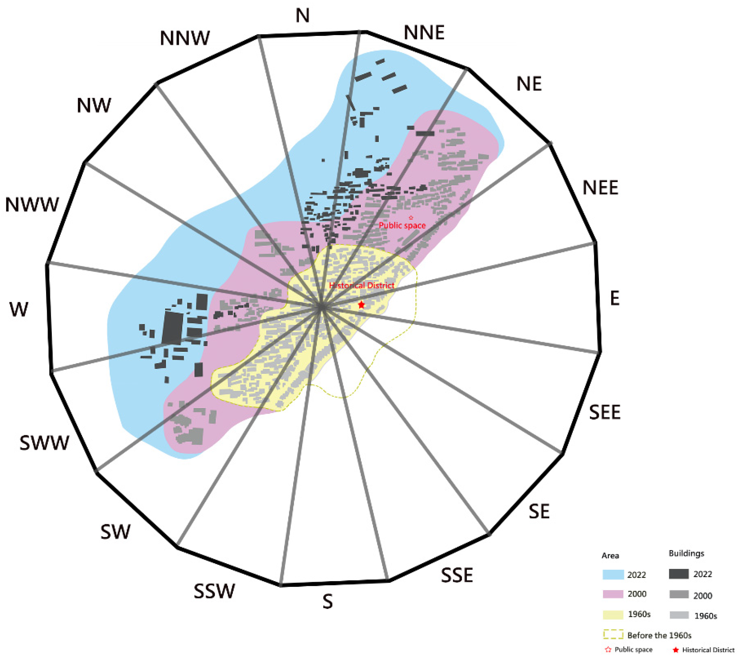
3.1. Study Area
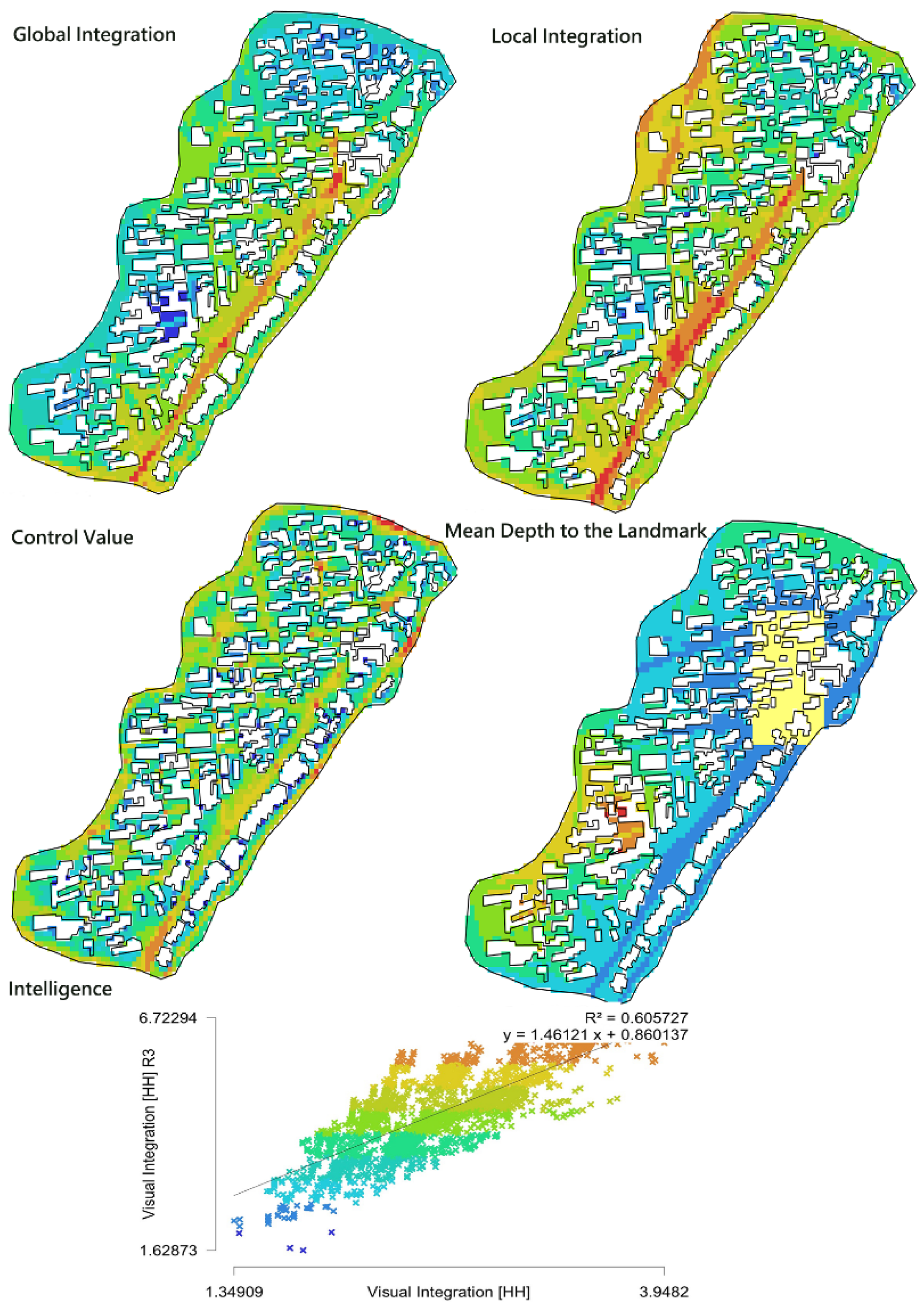
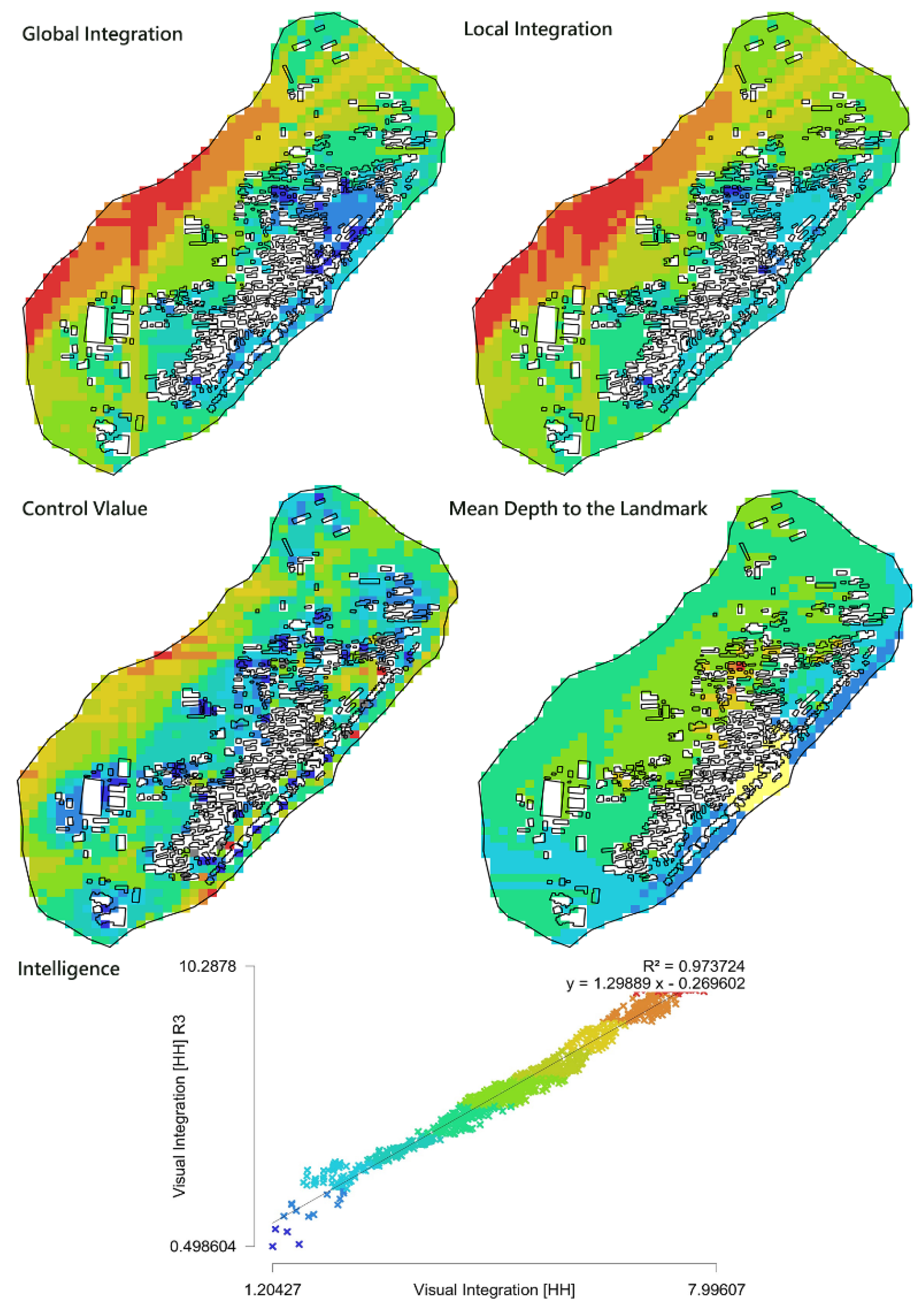
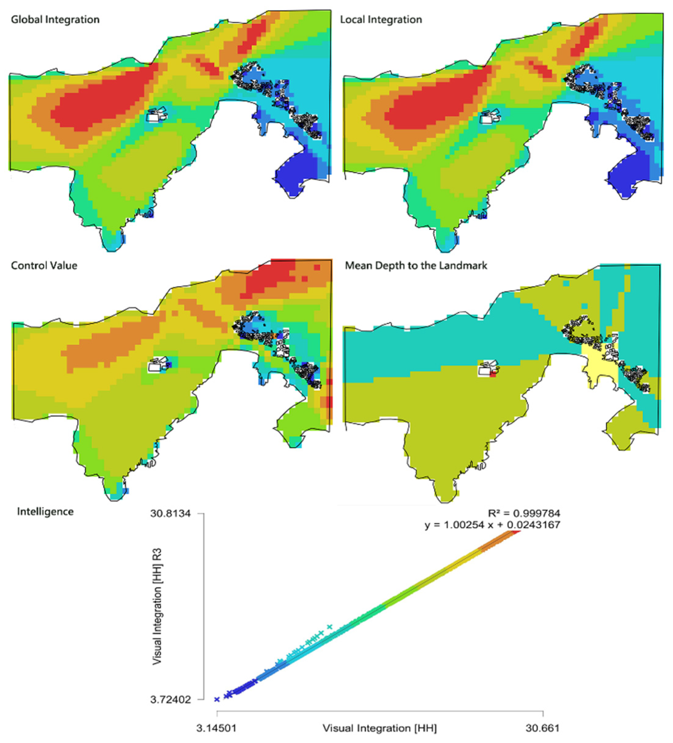
3.2. Space Syntax
- Calculating the total depth (TD), the sum of the number of connections between a particular nod and every other node in a certain space. N means the number of all nodes within a radius, and nx is the nodes for a given root at a given depth or level.
- 2.
- Calculating the mean depth (MD), demonstrating the denotation of the average depth value of all nodes within a radius. MD is the ratio of TD and the number of n minus one.
- 3.
- Calculating the relative asymmetry (RA), indicating the depth of the system from a particular node with the theoretically possible depth or shallowness of this system.
- 4.
- Calculating the real relative asymmetry (RRA). RRA not only indicates the depth of a node in a whole system but also in a suitably scales benchmark configuration [43].
- 5.
- Calculating the integration.
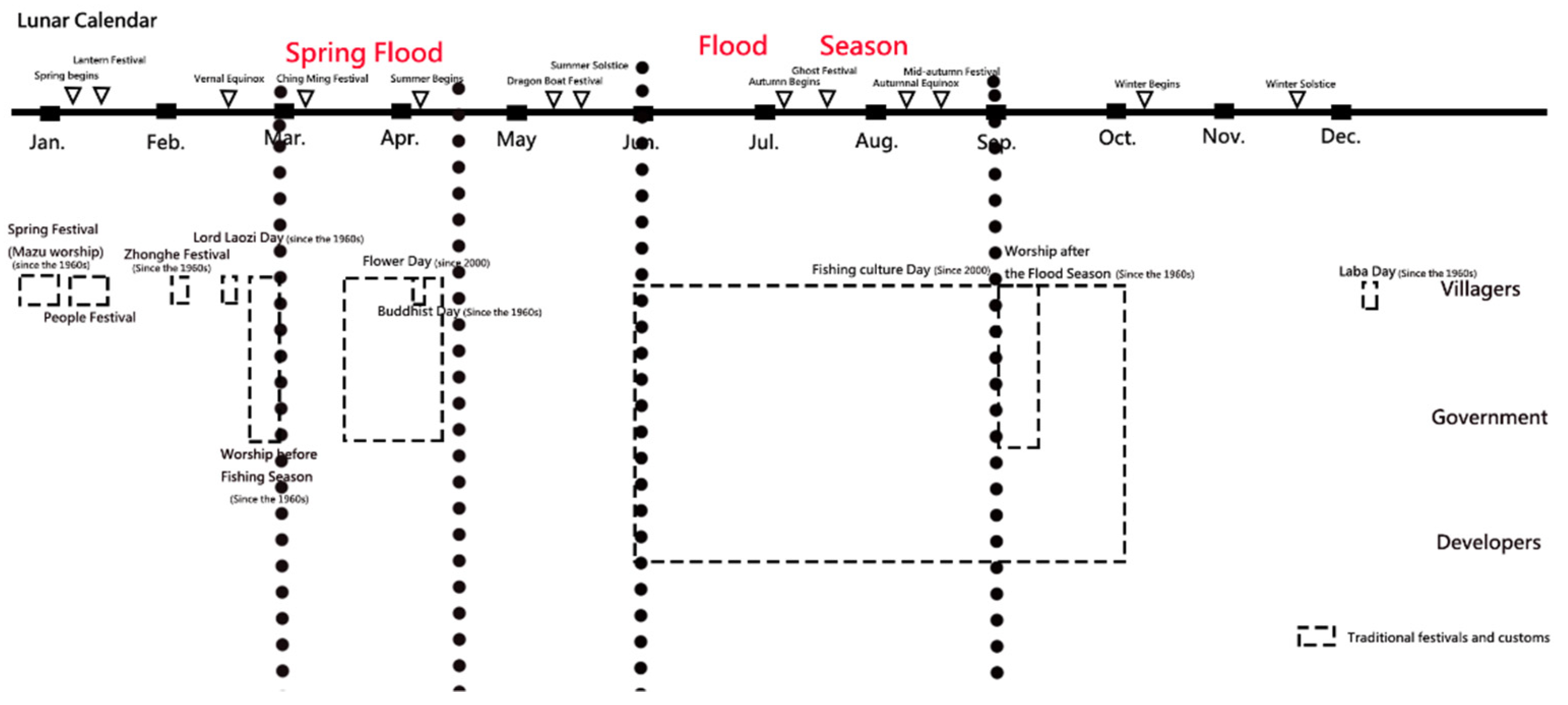
3.3. Socio-Historical Analysis
4. Results
4.1. Alterations of External Configurations at the Two Fishing Villages
4.2. Alterations of Internal Configurations at Two Fishing Villages
4.2.1. Jinshanzui Village
4.2.2. Tianao Village
5. Discussion
5.1. Patterns of the Historic Rural Landscape
5.1.1. Production-Led Historic Rural Landscape: Jinshanzui Village
5.1.2. Ecology-Led Historic Rural Landscape: Tianao Village
5.2. Mechanism of the Alteration of the Rural Landscape in the Fishing Villages
5.2.1. Ecological Elements
5.2.2. Production Elements
5.2.3. Living Elements
5.2.4. Mechanism of the Alteration of the Historic Landscape of the Fishing Villages
5.3. Implications
- Production-led pattern: spatial configuration and functions need to cooperate with the development of the production method. The production is altered with time and modern needs. Various production methods have different needs. For example, the fishery needs to be close to the raw materials; thus, sites were selected along the shore. Tourism needs to attract people, and a place with optimal accessibility and visibility tends to gather people. Thus, this type of space is suitable for tourism. The newly developed industry needs certain techniques and convenient traffic. A place with high intelligence and local integration tends to be accessible, independent, and coordinated with the surroundings, which suits the newly developed industry. A place with high local integration suits a residential area.The alteration of historic rural landscapes needs various types of subjective participation. Although the government takes the dominant role, the participation of social groups, the public, and academic institutions is also significant.Cultural connotation is the basis of the alterations of historic rural landscapes. The inheritance of culture has various methods, such as inheriting rural culture through decorations and activities in public space with optimal visibility.
- Ecology-led pattern: This relates to maintaining harmony between the natural environment and habitat areas in villages. It is important to ensure that the new landscape cannot damage the original ecology and that the ecological maintenance cannot damage the historic landscape. For ecology-led historic rural landscapes, ecological function plays an essential role in its alterations. When conserving the historic rural landscape, meeting modern needs also needs to be emphasized.The unique historical rural landscape can be displayed by decorating buildings and public spaces, such as fishing paintings on the walls of buildings and the fishing boats in the square of Tianao village. These decorations can evoke the identity of villagers and enhance their understanding of the village.
6. Conclusions
Author Contributions
Funding
Institutional Review Board Statement
Informed Consent Statement
Data Availability Statement
Conflicts of Interest
References
- United National Educational Scientific and Cultural Organization. Vienna Memorandum on “World Heritage and Contemporary Architecture-Managing the Historic Urban Landscape”. 2005. Available online: https://whc.unesco.org/en/documents/5965 (accessed on 2 April 2022).
- ICOMOS-IFLA. Principles Concerning Rural Landscape as Heritage. 2017. Available online: https://www.icomos.org/images/DOCUMENTS/Charters/GA2017_6-3-1_RuralLandscapesPrinciples_EN_adopted-15122017.pdf (accessed on 2 April 2022).
- Gullino, P.; Pomatto, E.; Gaino, W.; Devecchi, M.; Larcher, F. New Challenges for Historic Gardens’ Restoration: A Holistic Approach for the Royal Park of Moncalieri Castle (Turin Metropolitan Area, Italy). Sustainability 2020, 12, 10067. [Google Scholar] [CrossRef]
- Ozhanci, E.; Yilmaz, H. Visual assessment of rural landscape with different characters. Forestist 2019, 69, 44–60. [Google Scholar] [CrossRef]
- Pennisi, G.; Sanyé-Mengual, E.; Orsini, F.; Crepaldi, A.; Nicola, S.; Ochoa, J.; Gianquinto, G. Modelling environmental burdens of indoor-grown vegetables and herbs as affected by red and blue LED lighting. Sustainability 2019, 11, 4063. [Google Scholar] [CrossRef] [Green Version]
- Jia, Z.; Jiao, Y.; Zhang, W.; Chen, Z. Rural tourism competitiveness and development mode, a case study from Chinese township scale using integrated multi-source data. Sustainability 2022, 14, 4147. [Google Scholar] [CrossRef]
- Nelson, E.; Mendoza, G.; Regetz, J.; Polasky, S.; Tallis, H.; Cameron, D.; Shaw, M. Modeling multiple ecosystem services, biodiversity conservation, commodity production, and tradeoffs at landscape scales. Front. Ecol. Environ. 2009, 7, 4–11. [Google Scholar] [CrossRef]
- Wiggering, H.; Dalchow, C.; Glemnitz, M.; Helming, K.; Müller, K.; Schultz, A.; Zander, P. Indicators for multifunctional land use—Linking socio-economic requirements with landscape potentials. Ecol. Indic. 2005, 6, 238–249. [Google Scholar] [CrossRef]
- Paracchini, M.; Pacini, C.; Jones, M.; Pérez-Soba, M. An aggregation framework to link indicators associated with multifunctional land use to the stakeholder evaluation of policy options. Ecol. Indic. 2009, 11, 71–80. [Google Scholar] [CrossRef]
- Reidsma, P.; König, H.; Feng, S.; Bezlepkina, I.; Nesheim, I.; Bonin, M.; Brouwer, F. Methods and tools for integrated assessment of land use policies on sustainable development in developing countries. Land Use Policy 2010, 28, 604–617. [Google Scholar] [CrossRef]
- European Commission. Safeguarding the Multifunctional Role of Agriculture: Which Instruments? Brussels: DG Agriculture-European Commission. 1999. Available online: https://www.iatp.org/sites/default/files/Safeguarding_the_Multifunctional_Role_of_EU_Ag.htm (accessed on 15 April 2022).
- Lovell, S.; DeSantis, S.; Nathan, C.; Olson, M.; Ernesto Méndez, V.; Kominami Hand Morris, W.B. Integrating agroecology and landscape multifunctionality in Vermont: An evolving framework to evaluate the design of agroecosystems. Agric. Syst. 2010, 103, 327–341. [Google Scholar] [CrossRef]
- Verburg, P.; Van de Steeg, J.; Veldkamp, A.; Willemen, L. From land cover change to land function dynamics: A major challenge to improve land characterization. J. Environ. Manag. 2009, 90, 1327–1335. [Google Scholar] [CrossRef]
- Makhzoumi, J. Unfolding Landscape in a Lebanese Village: Rural Heritage in a Globalising World. Int. J. Herit. Stud. 2009, 15, 317–337. [Google Scholar] [CrossRef]
- Taylor, K.; Lennon, J. Cultural landscapes: A bridge between culture and nature? Int. J. Herit. Stud. 2011, 17, 537–554. [Google Scholar] [CrossRef]
- Andersen, P.; Vejre, H.; Dalgaard, T.; Brandt, J. An indicator-based method for quantifying farm multifunctionality. Ecol. Indic. 2013, 25, 166–179. [Google Scholar] [CrossRef]
- Avni, N. “So long, and thanks for all the fish?” Examining the built and cultural heritage of the Jaffa port redevelopment. Int. J. Herit. Stud. 2017, 23, 679–694. [Google Scholar] [CrossRef]
- Fleischer, A.; Tchetchik, A. Does rural tourism benefit from agriculture? Tour. Manag. 2005, 26, 493–501. [Google Scholar] [CrossRef]
- Willemen, L.; Hein, L.; Van Mensvoort, M.; Verburg, P. Space for people, plants, and livestock? Quantifying interactions among multiple landscape functions in a Dutch rural region. Ecol. Indic. 2010, 10, 62–73. [Google Scholar] [CrossRef]
- Jiang, G.; Wang, M.; Qu, Y.; Zhou, D.; Ma, W. Towards cultivated land multifunction assessment in China: Applying the “influencing factors-functions-products-demands” integrated framework. Land Use Policy 2020, 99, 104982. [Google Scholar] [CrossRef]
- Jiří, P.; Ondřej, K.; Jiří, H.; Michal, L. Beyond the story of the LEADER projects: Are organic farmers actors of multifunctionality and rural development? Land Use Policy 2022, 116, 106046. [Google Scholar] [CrossRef]
- Xiong, J.; Chen, D.; Peng, B.; Deng, S.; Xie, X. Spatio-temporal difference of coupling coordinative degree of ecological carrying capacity in the Dongting Lake Region. Sci. Geogr. Sin. 2014, 34, 1108–1116. [Google Scholar] [CrossRef]
- Wei, J.; Qi, C. Coupling coordination degree analysis of the agricultural technology progress and factor endowment in China. China Popul. Resour. Environ. 2015, 25, 90–96. [Google Scholar] [CrossRef]
- Liang, W.; Liu, M. A study on the coupling and coordinated development and tempo-spatial variation of China’s strategic emerging industries and traditional industries. Econ. Geogr. 2017, 37, 117–126. [Google Scholar] [CrossRef]
- Ginzarly, M.; Houbart, C.; Teller, J. The Historic Urban Landscape approach to urban management: A systematic review. Int. J. Herit. Stud. 2019, 25, 999–1019. [Google Scholar] [CrossRef]
- Xu, Y.; Wang, D.; Sha, M. Morphological evolution and influence mechanism of Suzhou urban space from the perspective of double dimension. Econ. Geogr. 2019, 39, 75–84. [Google Scholar] [CrossRef]
- Batty, M. Cities as fractals simulating growth and form. In Fractals and Chaos; Crilly, A.J., Jones, H., Eds.; Springer: New York, NY, USA, 1991; pp. 63–69. [Google Scholar]
- Xu, L.; Dong, J.; Li, L.; Zhang, J. Characteristics and optimization of geographical space in urban agglomeration in the middle reaches of the Yangtze River based on the function zoning. Econ. Geogr. 2017, 37, 76–83. [Google Scholar] [CrossRef]
- Chen, Q. The fusion of the sacred and the profane and the expansion of the space of belief—A Study of religious anthropology in a Hokkien sishing village. Qinghai J. Ethnol. 2019, 3, 215–221. [Google Scholar] [CrossRef]
- Pascht, A. Preservation or diversification? Ideas and practices connected with sustainability in Vanuatu. Sustainability 2022, 14, 4733. [Google Scholar] [CrossRef]
- Zhang, C. Baizu Traditional Ethnic Architecture; Yunnan National Press: Kunming, China, 2007. [Google Scholar]
- Xia, J.; Che, Z. Tourist stare study of travel small towns: A case study of Shuanglang Town in Dali City. Huazhong Archit. 2016, 8, 114–117. [Google Scholar]
- Committee of Jinshan County Chronicles. Jinshan County Chronicles; Shanghai Academy of Social Science Press: Shanghai, China, 2020. [Google Scholar]
- Zhu, J.; Shang, T.; Yu, N. Recreational fisheries in China. Chin. Fish. Econ. 2010, 28, 1650169. [Google Scholar]
- Committee of Shengsi County Chronicles. Shengsi County Chronicles; Zhejiang People Press: Hangzhou, China, 2020. [Google Scholar]
- Xu, D.; Ding, Y. Analysis and design strategy of the current design of buildings at the fishing villages: The case of building cluster of fishing painting studios in Tianao village. Hous. Real Estate 2018, 2, 214–216. [Google Scholar]
- Hillier, W.; Yang, T.; Turner, A. Normalising least angle choice in Depthmap—And how it opens up new perspectives on the global and local analysis of city space. J. Space Syntax. 2012, 3, 155–193. [Google Scholar]
- Huang, B.; Chiou, S.; Li, W. Study on courtyard residence and cultural sustainability: Reading Chinese traditional Siheyuan through space syntax. Sustainability 2019, 11, 1582. [Google Scholar] [CrossRef] [Green Version]
- Turner, A.; Doxa, M.; O’Sullivan, D.; Penn, A. From Isovists to Visibility Graphs: A Methodology for the Analysis of Architectural Space. Environ. Plan. B Urban Anal. City Sci. 2001, 28, 103–121. [Google Scholar] [CrossRef] [Green Version]
- Koohsari, M.; Nakaya, T.; McCormack, G.; Shibata, A.; Ishii, K.; Yasunaga, A.; Oka, K. Traditional and novel walkable built environment metrics and social capital. Landsc. Urban Plan. 2021, 214, 104184. [Google Scholar] [CrossRef]
- Hillier, B. Space Is the Machine; Cambridge University Press: Cambridge, UK, 1999. [Google Scholar]
- Hillier, B. The Social Logic of Space; Cambridge University Press: Cambridge, UK, 1989. [Google Scholar]
- Ostwald, M.J. The mathematics of spatial configuration: Revisiting, revising and critiquing justified plan graph theory. Nexus Netw. J. 2011, 13, 4450470. [Google Scholar] [CrossRef] [Green Version]
- Zhai, Y.; Baran, P. Do configurational attributes matter in context of urban parks? Park pathway configurational attributes and senior walking. Landsc. Urban Plan. 2016, 148, 188–202. [Google Scholar] [CrossRef]
- Engles, F. The Conditions of the Working Class in England; No Publisher Cited: Manchester, UK, 1845; Available online: https://www.marxists.org/archive/marx/works/download/pdf/condition-working-class-england.pdf (accessed on 17 April 2022).
- Herbert, D.T. Urban Geography: S Social Prespective; Praeger: New York, NY, USA, 1971. [Google Scholar]
- Pinell, P. The birth of cancerology in France A socio-historical approach. Cancer J. 1987, 1, 383–387. [Google Scholar]
- Aguirre, A.; Baker, D. Slave Executions in the United States: A Descriptive Analysis of Social and Historical Factors. Soc. Sci. J. 1999, 36, 1–31. [Google Scholar] [CrossRef]
- Wu, A.; Lau, J. Gambling in China: Socio-historical evolution and current challenges. Addiction 2015, 110, 210–216. [Google Scholar] [CrossRef]
- Saunder, P. Space, the city and urban sociology in geography. In Social Relations and Spatial Structures; Gregory, D., Urry, J., Eds.; Palgrave Macmillan: London, UK, 1985. [Google Scholar]
- Castells, M. The Urban Question: A Marxist Approach; The MIT Press: Cambridge, UK, 1972. [Google Scholar]
- Chen, X. African Americans and Wildlands: A Case Study in Alabama, USA. J. Hum. Ecol. 2009, 26, 19–24. [Google Scholar] [CrossRef]
- Steen-Adams, M.; Mladenoff, D.J.; Langston, N.; Liu, F. Influence of Biophysical Factors and Differences in Ojibwe Reservation versus Euro-American Social Histories on Forest Landscape Change in Northern Wisconsin, USA. Landsc. Ecol. 2011, 26, 1165–1178. [Google Scholar] [CrossRef]
- Subin-Kozhevnikova, A.; Smoliak, V. The Impact of Natural Landscape on Historical Urban Space: The Case of Vinnytsia City, Ukraine. Archit. Civ. Eng. Environ. 2018, 11, 39–47. [Google Scholar] [CrossRef] [Green Version]
- Wei, L. Distribution and changes of coastal aquaculture lands in Hangzhou Bay and its surrounding areas for 6 periods since 1986. Wetl. Sci. 2021, 19, 534–542. [Google Scholar]
- Kang, Y.; Cheng, R.; Liang, Q. The characteristic of spatio-temporal evalution analysis of Hangzhou Bay in historical period. J. Zhejiang Norm. Univ. (Nat. Sci.) 2019, 42, 88–95. [Google Scholar] [CrossRef]
- Meng, X.; Wang, Y.; Chen, Z. Status and countermeasure study of fishery leisure industry development in Shengsi County. Fish. Inf. Strategy. 2011, 26, 20–22. [Google Scholar] [CrossRef]
- Sheng, F.; Li, Z. Study on the evolution, characteristics and future policy of fishing ban policy in China. Agric. Archaeol. 2021, 4, 155–160. [Google Scholar]
- Luo, Z.; Dou, P. Study on the current situtaion and strategies of events and activities of rural tourism: The case of Jinshanzui village. Rural. Econ. Sci.-Technol. 2021, 32, 83–87. [Google Scholar] [CrossRef]


| Variables | 1960s | 2000 | 2022 |
|---|---|---|---|
| Global Integration | |||
| Average | 2.553 | 2.896 | 4.982 |
| Minimum | 1.350 | 0.898 | 1.204 |
| Maximum | 3.948 | 4.721 | 7.996 |
| Std. Dev. | 0.456 | 0.691 | 1.477 |
| Local Integration | |||
| Average | 4.590 | 4.552 | 6.200 |
| Minimum | 1.629 | 0.566 | 0.499 |
| Maximum | 6.723 | 6.686 | 10.288 |
| Std. Dev. | 0.856 | 1.050 | 1.944 |
| Intelligence | 0.606 | 0.818 | 0.947 |
| Control Value | |||
| Average | 0.997 | 1.008 | 1.007 |
| Minimum | 0.047 | 0.096 | 0.047 |
| Maximum | 0.02 | 2.697 | 2.203 |
| Std. Dev. | 0.352 | 0.329 | 0.396 |
| Mean Depth to the Landmark | |||
| Average | 2.178 | 2.791 | 2.963 |
| Std. Dev. | 1.352 | 0.964 | 0.962 |
| Variables | 1960s | 2000 | 2022 |
|---|---|---|---|
| Global Integration | |||
| Average | 19.062 | 11.927 | 4.375 |
| Minimum | 3.145 | 1.826 | 0.502 |
| Maximum | 30.661 | 20.712 | 6.391 |
| Std. Dev. | 6.760 | 4.229 | 1.273 |
| Local Integration | |||
| Average | 19.134 | 13.920 | 9.400 |
| Minimum | 3.724 | 1.113 | 0.499 |
| Maximum | 30.813 | 25.079 | 21.001 |
| Std. Dev. | 6.778 | 5.223 | 3.252 |
| Intelligence | 1.000 | 0.969 | 0.658 |
| Control Value | |||
| Average | 1.000 | 1.001 | 1.010 |
| Minimum | 0.008 | 0.019 | 0.024 |
| Maximum | 1483 | 2.187 | 2.783 |
| Std. Dev. | 0.224 | 0.264 | 0.290 |
| Mean Depth to the Landmark | |||
| Average | 1.488 | 2.532 | 2.407 |
| Std. Dev. | 0.554 | 0.613 | 0.890 |
| Villages | 1960s | 2000 | 2022 |
|---|---|---|---|
| Jinshanzui village | Inhabitants | The government, visitors, and inhabitants | The government, the inhabitants, visitors, the academics, social groups |
| Tianao village | The government | The government and inhabitants | The government, inhabitants, and visitors |
Publisher’s Note: MDPI stays neutral with regard to jurisdictional claims in published maps and institutional affiliations. |
© 2022 by the authors. Licensee MDPI, Basel, Switzerland. This article is an open access article distributed under the terms and conditions of the Creative Commons Attribution (CC BY) license (https://creativecommons.org/licenses/by/4.0/).
Share and Cite
Chen, Y.; Wei, W. Alterations of Historic Rural Landscape Based on the Multifunctional Approach: The Case of Coastal Fishing Villages in the Yangtze River Basin. Sustainability 2022, 14, 7451. https://0-doi-org.brum.beds.ac.uk/10.3390/su14127451
Chen Y, Wei W. Alterations of Historic Rural Landscape Based on the Multifunctional Approach: The Case of Coastal Fishing Villages in the Yangtze River Basin. Sustainability. 2022; 14(12):7451. https://0-doi-org.brum.beds.ac.uk/10.3390/su14127451
Chicago/Turabian StyleChen, Yueying, and Wenbin Wei. 2022. "Alterations of Historic Rural Landscape Based on the Multifunctional Approach: The Case of Coastal Fishing Villages in the Yangtze River Basin" Sustainability 14, no. 12: 7451. https://0-doi-org.brum.beds.ac.uk/10.3390/su14127451