Article

Management and Mapping Ecosystem Services in a Privately Owned Natura 2000 Site: An Insight into the Stellantis–La Mandria Site (Italy)

1
Department of Agricultural, Forest and Food Sciences, University of Turin, 10095 Grugliasco, Italy
2
Department of Cultures, Politics and Society, University of Turin, 10153 Torino, Italy
3
CSC—Centro Studi per lo Sviluppo Rurale della Collina, University of Turin, 14100 Asti, Italy
4
Ente di Gestione delle Aree Protette dei Parchi Reali, 10078 Venaria Reale, Italy
5
Stellantis FCA Prototype & Validation Builds, 10135 Torino, Italy
*
Author to whom correspondence should be addressed.
Sustainability 2022, 14(5), 3134; https://0-doi-org.brum.beds.ac.uk/10.3390/su14053134
Submission received: 19 January 2022 / Revised: 5 March 2022 / Accepted: 6 March 2022 / Published: 7 March 2022
(This article belongs to the Special Issue Sustainable Rural Landscape: Study, Planning, and Design)

Abstract

:
The Natura 2000 network is an ecological network covering the whole territory of the European Union to ensure the long-term maintenance of threatened or rare natural habitats and species of flora and fauna, including in metropolitan and rural areas. Some of the Natura 2000 sites have been subject to changes in ownership that have led to a fragmentation of the territory. Private entities may own areas within a Natura 2000 site and must ensure sustainable management of their property, especially from an ecological point of view. The case study is the Stellantis–La Mandria site, a private area owned by Stellantis, within the Natura 2000 site “ZSC IT1110079 La Mandria”, near Turin. The research proposes a participatory methodology, mainly addressed in this first phase to experts and professionals and aimed at the valorisation and management of private Natura 2000 sites previously considered as industrial sites, to allow a careful fruition and safeguarding of the natural heritage. The aim of the research is to provide a methodological approach and the first qualitative results useful to providing the owners with an indication for a more targeted management of the site; mapping the areas that provide ecosystem services (ES, especially cultural ones); mapping the areas that could be subject to future fruition; collaborating with the managing body to collect useful data for the future drafting of a new area plan. Two main research activities were carried out, a SWOT (strengths, weaknesses, opportunities, and threats) analysis concerning the management and possible future fruition of the site and a participatory mapping of ES. It should be emphasised that the research allowed the first results to be obtained, which, on the one hand, make it possible to validate the methodology used to achieve the objectives and, on the other hand, the results will have to be implemented over time by involving numerous stakeholders among those who can access the private area. The results of the research highlight opportunities and threats with regard to the conservation of ecological–environmental characteristics and future fruition of the site. The participatory mapping identifies areas with different ecological value and, therefore, different management needs and identifies areas that could be used differently for future fruition. Overall, the results aim to meet some of the European Commission’s wishes regarding Natura 2000 sites, with particular reference to the involvement of different stakeholders and experts for the conservation of biodiversity and the integration of ecological and social aspects into the management and fruition plans.

1. Introduction

The Natura 2000 network is the main instrument of the European Union policy for the conservation of biodiversity, both in metropolitan areas and in rural and mountainous areas. This ecological network covers 28 European countries with the aim of ensuring the long-term survival of rare and endangered species of flora and fauna and habitats listed in both the Birds Directive (2009/147/EC) and the Habitats Directive (92/43/EEC) [1]. There are 27,758 Natura 2000 sites in Europe, covering around 18% of the territory [2].
In 2021, 2637 sites belonging to the Natura 2000 Network were identified in the Italian regions. In particular, 2358 sites of community importance (SCI) have been identified, 2297 of which have been designated as special areas of conservation (SAC), and 636 as special protection areas (SPA). Within the Natura 2000 sites in Italy, a total of 132 habitats, 90 species of flora, and 114 species of fauna (of which 22 mammals, 10 reptiles, 16 amphibians, 26 fish, and 40 invertebrates) are protected under the Habitats Directive; approximately 391 species of birds are protected under the Birds Directive [3]. Some of these sites are historically characterised by strong human–nature interactions (such as ecotourism/visiting a national park, smelling the scent of wildflowers [4]), which are characterised by the local landscape requiring specific attention to management practices [5]. Human activities in the Natura 2000 Network are therefore often encouraged and must be carried out in a sustainable way. Specifically, several documents produced by the European Commission have often emphasised the concept of ecosystem services and the need to protect and manage these areas through the adoption of management plans drawn up following the stakeholder involvement [6,7].
A participatory approach to decision-making regarding the management and fruition of Natura 2000 sites is essential [8], with the aim of conserving the biodiversity of habitats and ensuring adequate local economic development [9]. This approach considers the knowledge and needs of the stakeholders of Natura 2000 sites [10,11], integrating social aspects into management plans, which generally focus on the ecological and conservation aspects [12].
These considerations are more important for areas that have undergone changes in ownership over time that have sometimes led to a fragmentation of the territory. It is therefore not uncommon for private parties to own areas within Natura 2000 sites, and they have an obligation to properly manage the properties.
Specific attention is paid to private areas in urban and peri-urban realities, where often some economic activities have been reduced or suspended following the designation of the area as SIC or SAC.
Studies about the private-owned areas are still scarce, mainly concentrated in northern and eastern European areas and focused on the compensation mechanism within the European Rural Development Programmes [13,14] and private investment and protection activities in Natura 2000 sites [15]. A few studies focus on the involvement of experts and stakeholders on the perception of ecosystem services and the need to share management practices [16,17].
Fewer research seem to also focus on the private areas of the Mediterranean and Southern Europe, especially those focused on the involvement of stakeholders and experts in the phases of perception of ecosystem services and management of a Natura 2000 site, with a few exceptions [18]. In addition, experts and stakeholders can participate in the formulation and implementation of the Natura 2000 in different ways, but there are no specific recommendations about participation [17].
The management activities of a Natura 2000 site are included and defined by a management plan, with the aim of safeguarding the structure and the function of the habitats and the long-term conservation of the species, considering at the same time the social and economic factors characterizing the area.
All Natura 2000 sites must be under a management plan that includes aspects of recreational and nature tourism and sometimes also their impact on the ecological characteristics of the sites. In Europe, there are numerous studies in this regard. Research in the Azores has shown the impact of the presence of trails on the richness and diversity of plant communities, although without major changes in floristic composition. Trails provide a habitat for plant species that is somewhat different from the core of the surrounding plant communities, with the number of species decreasing with distance from the margin of the trail [19]. Among the activities related to the fruition of Natura 2000 sites in Europe, hunting, fishing, and tourism are more frequently recorded in southern European sites than in the northern or eastern ones. These activities are often understood at an ecological level as a source of disturbance and as activities that provide financial benefits to local communities and as a source of funding for conservation [20]. In Italy, however, the predominant recreational activities were hiking, cycling, and wine and food tasting. The average daily expenditure of visitors using the site for recreational purposes and tourism amounted to approximately EUR 50 [21]. This amount could be used to implement environmental education activities and to preserve the ecological characteristics of the sites. In fact, although the main objective of Natura 2000 sites is related to the valorisation of natural resources, it is also important to underline their importance in promoting educational and/or didactic fruition in schools and local communities [22].
The La Mandria site also has a management plan to be applied in private and public areas. However, few in-depth studies had been carried out on the study area (with the exception of some sporadic monitoring of the ungulates and flora present but not organically over the whole site), especially with the intention of combining management requirements with a new fruition of the site. Implementations to the management plan are possible and need to be developed and defined with the involvement of experts and local stakeholders [23].
It is especially in these (private) areas that it is necessary to rebuild relations with the people who might live, work, or visit these sites, also setting up specific and differentiated communication strategies to raise awareness of nature conservation [24,25], guaranteeing a fruition aimed at admiring and appreciating the ecological characteristics of the site.
The research proposes a participatory methodology addressed to experts inside and outside a private area of a Natura 2000 site, aimed at enhancing and managing Natura 2000 sites, safeguarding the natural heritage, responding to a need for new fruition of the site, and mediating between public and private interests.
The case study is represented by the private area owned by Stellantis in the protected park and Natura 2000 site “ZSC IT1110079 La Mandria”, north-west of Turin (Italy).
Specifically, the objectives are to provide the owners with an indication for a more targeted management of the site; to map the areas that provide cultural ecosystem services; to identify the areas that could host a future fruition of the site (especially outdoor fruition and tourism). The intention of the study is to provide an introductory expert investigation and then to involve further stakeholders, such as citizens of neighbouring cities, to integrate their perceptions and perspectives.
It should be highlighted that the methodologies used to achieve the objectives are based on the active participation of different stakeholders. Initially, the owners allowed access to the site to specific stakeholders (all experts in the management and conservation of areas of high ecological value) for two main reasons: the scarce environmental information available after years of limited or no access to the site and the ecological characteristics of the area; the restrictions imposed by the COVID-19 pandemic situation.
In the future, it may be possible to involve different stakeholders and confirm the current results obtained or to note different points of view for subsequent modifications. In addition, the owners of the site needed a practical and immediately usable tool to start making the site—which has been little or not at all used for years— fruitive in the short term. For this reason, the research tries to reconcile the two needs: to provide an initial operational tool to make the site usable while respecting its intrinsic ecological values; to set up a research methodology that can be replicated over time, involving different stakeholders over several years of fruition of the site. This is why the research proposes a first insight into the Stellantis–La Mandria site (Italy).
The aim of the research is to provide a methodological approach and the first qualitative results useful to provide the owners with an indication for a more targeted management of the site; to map the areas that provide ecosystem services (ES, especially cultural ones); to map the areas that could be subject to future fruition; to collaborate with the managing body to collect useful data for the future drafting of a new area plan.
The results of the research aim to fulfil some of the expectations stated by the European Commission regarding Natura 2000 sites, which indicate that the involvement of different stakeholders and experts in these areas is fundamental for the conservation of biodiversity, integrating ecological and social aspects into the management and fruition plans.

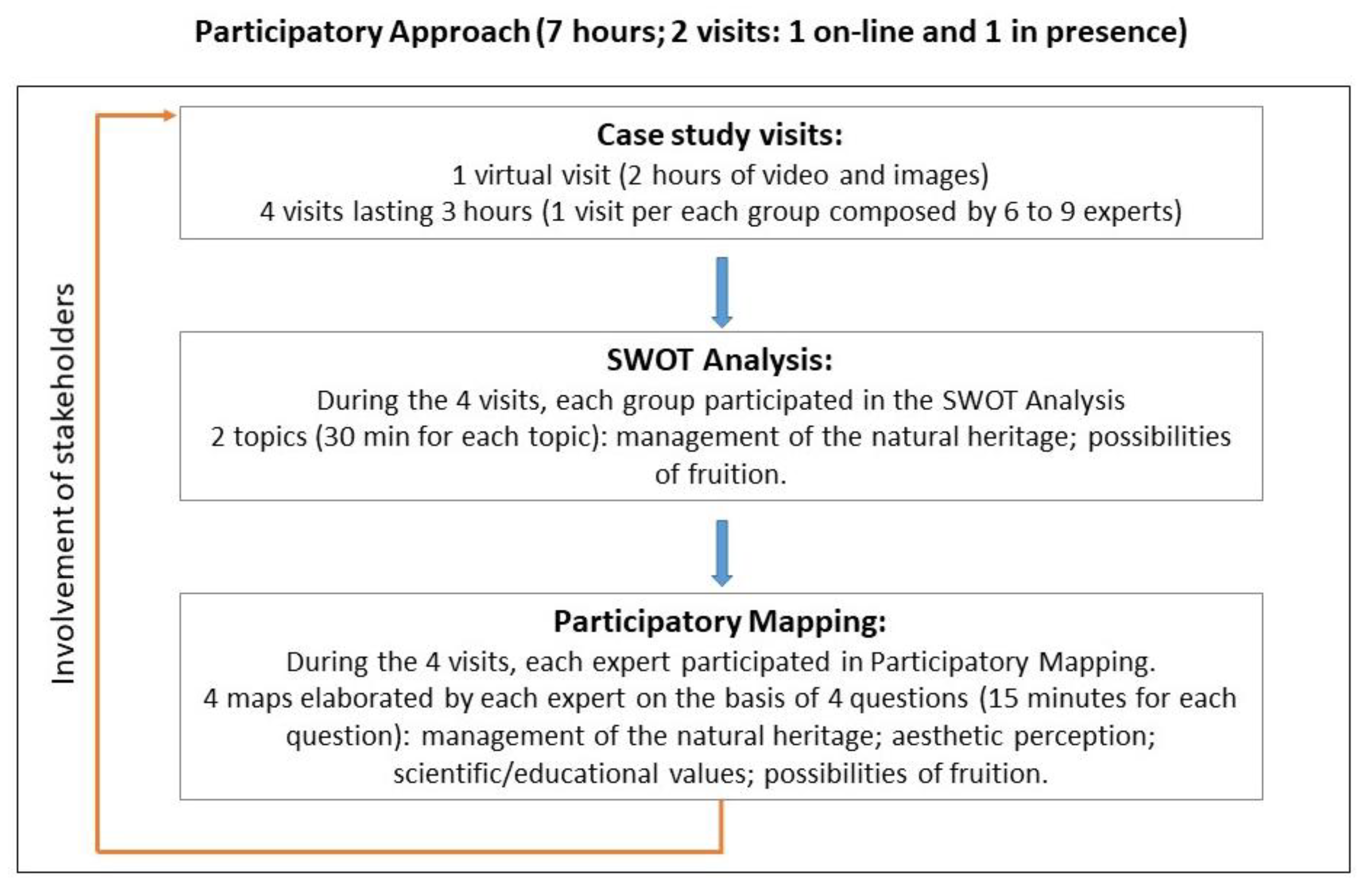
2. Materials and Methods
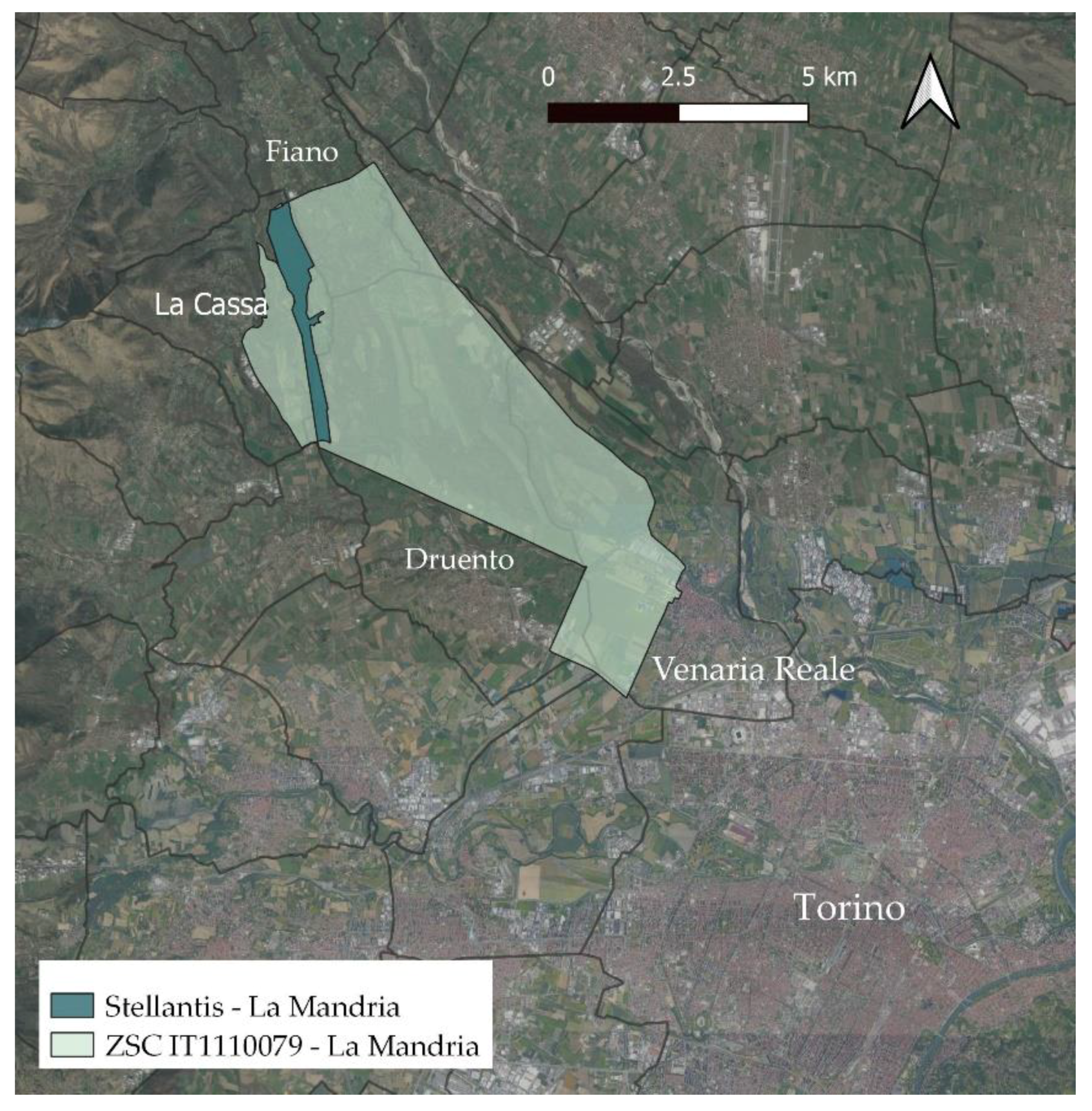
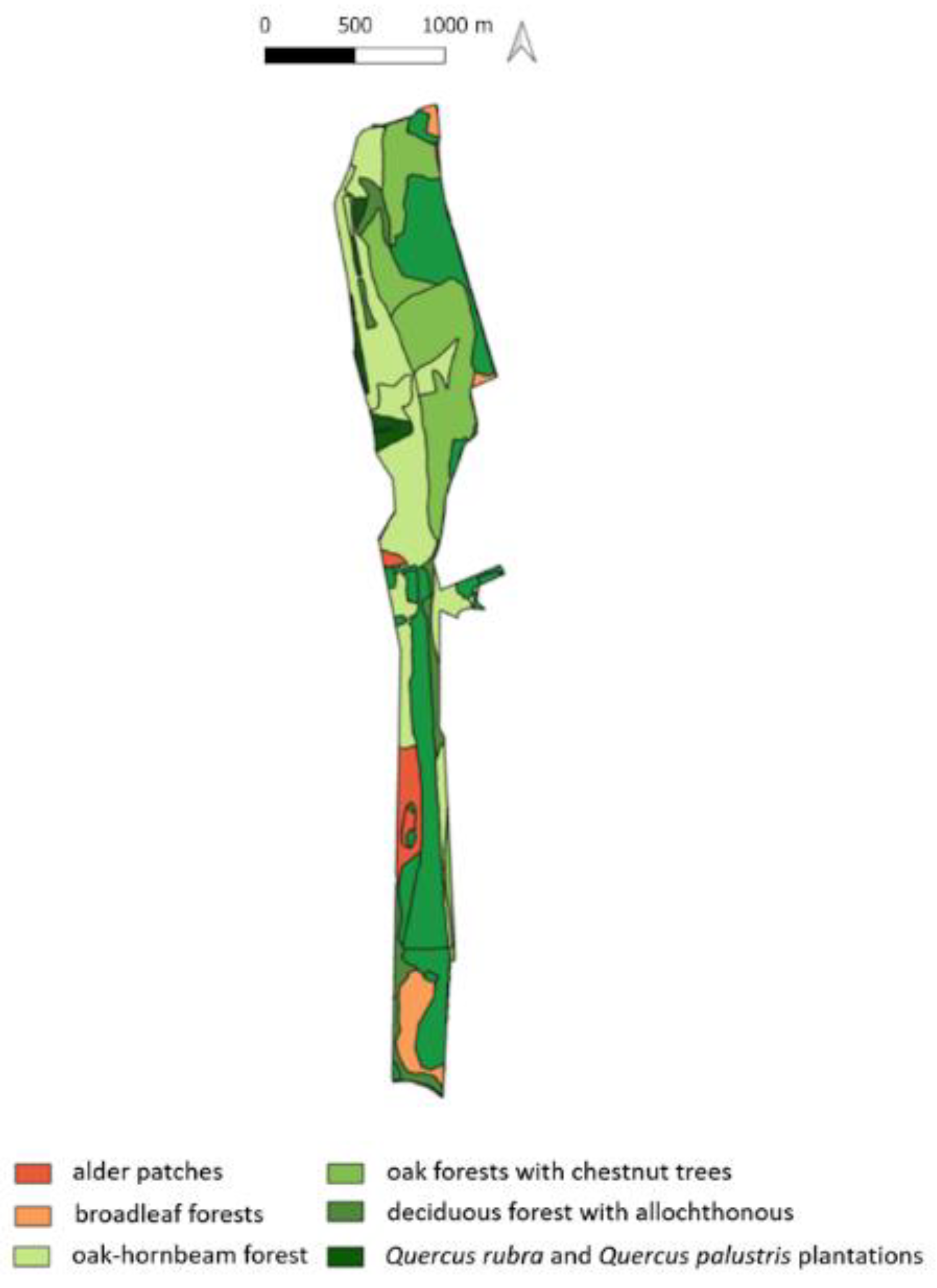
2.1. Case Study

The case study is the Stellantis–La Mandria site, a private area owned by Stellantis and within the Natura 2000 site, “ZSC IT1110079 La Mandria” (Italy). The site of the case study is located on the borders of the municipalities of Torino (Turin), Fiano, La Cassa, and Venaria Reale (Figure 1).
“ZSC IT1110079 La Mandria” extends over the conoid of the Stura di Lanzo stream and is enclosed by about 30 km of walls.
Since 2007, the case study site has been declared a protected park, thus preventing the company from carrying out several activities. In the following years, the area has remained poorly used, until today as Stellantis’ interest in environmental issues is growing and the desire to enhance and redevelop the area is tangible.
The area owned by Stellantis has an elongated shape with a morphology consisting of a short flat stretch on alluvial soil and an escarpment sloping northwestwards with a difference in height of about 100 m. The Stellantis site covers an area of 1,585,000 m2, of which 210,000 m2 are occupied by anthropogenic elements and the remaining hectares by woods, grasslands, and wetlands. Among the areas of high ecological value, the wooded areas are noteworthy. They host different species that partly preserve historical plant species and partly have undergone anthropic pressure aimed at the cultivation of species for productive use. The main forest patches that compose the site are shown in Figure 2.
The peculiarities of the case study include the presence of oak-hornbeam forests, which have almost disappeared in Piedmont and old acidophilic oak forests of the sandy plains with Quercus robur L.

2.2. Methods

To achieve the planned objectives, two main methodologies were as followed: SWOT analysis and participatory mapping by experts (Figure 3).
These methodologies are based on the active participation of many experts who were frequently involved in the research during the period of March–July 2020 and September-December 2020. The people who actively participated were employees of Stellantis; agronomists; university lecturers from the ‘Centro Studi per lo Sviluppo Rurale della Collina’ (CSC); the management body of the protected areas of the Royal Parks (Regione Piemonte); professors from the Department of Agricultural, Forestry and Food Sciences and the Department of Veterinary Sciences of the University of Turin. The research activities involved 30 experts with expertise in agronomic and forest management of Natura 2000 sites; fauna experts; environmental sustainability; experts in the management of aquatic environments; pedologists; university lecturers with expertise in the management and design of green areas and landscape ecology. All the experts were familiar with the regulations in force concerning the management of the Natura 2000 areas, with particular attention to the specificities of the Piedmont region.
The first step was for all the experts to visit the area. A first virtual site visit was organised, showing maps, documents, photos, and videos of the study area. Subsequently, visits were conducted within the site, organised in small groups (6–9 people), following the restrictions imposed by the pandemic.
Following the field visits, the experts were asked to carry out two main activities:
  • Analysis of strengths, weaknesses, opportunities, and threats (SWOT) regarding the management and possible future fruition of the case study;
  • Participatory mapping concerning the management of the site, the provision of ecosystem services and the indication of areas suitable for a future fruition of the Stellantis–La Mandria site:
    -
    Subdivide the case study into areas that need to be managed differently according to ecological and environmental characteristics and what was observed during the field visits;
    -
    Subdivide the case study into areas with different qualities and perceptions from an aesthetic point of view (cultural ecosystem services);
    -
    Subdivide the case study into areas of different scientific/educational value (cultural ecosystem services);
    -
    Subdivide the case study into areas that can accommodate different forms of fruition in the future, avoiding disturbance and damage to the environmental heritage.
The two activities took place one after the other (as shown in Figure 3), but the SWOT analysis was carried out by the experts in groups, while the participatory mapping was an individual activity.

2.2.1. SWOT Analysis

The SWOT analysis allows the identification of strengths, weaknesses, opportunities, and threats in achieving specific objectives. This analysis was invented around the 1950s in the field of marketing research and has evolved over time to find applications in strategic planning processes and in the field of spatial management [26], and it is often combined with other analysis techniques, including participatory mapping [27].
The SWOT analysis [26] is based on a discussion and identification (usually in groups) of the internal factors or endogenous variables (strengths and weaknesses) and external factors or exogenous variables (opportunities and threats) necessary to achieve each objective. The endogenous variables include all those variables that are an integral part of the system itself (e.g., organisational structure, capital, technologies), on which it is possible to intervene to pursue pre-set objectives. Among the endogene variables, on the other hand, there are variables that are external to the system (e.g., the cultural environment, the natural environment) but which can influence it both positively and negatively. The logical–operational scheme of the SWOT analysis is based on identification of the objective; identification of the exogenous and endogenous variables; application of the strategy to achieve the objective; verification of the results over time. The results of the analysis are generally reported on a matrix divided into four opposing and open fields devoted respectively to strengths and weaknesses, opportunities, and threats.
In our case study, the objectives identified and discussed during the meetings with the expert group were:
-
Management of the natural (ecological/environmental) heritage of the site;
-
Future possibilities for the fruition of the Stellantis–La Mandria site.
The results of the SWOT were reported in matrices. The contents and reflections were considered for the subsequent mapping of the management and fruition aspects of the case study.

2.2.2. Participatory Mapping

Participatory mapping is a methodology of analysis that allows us to identify points or areas on a map that are particularly important for the achievement of specific objectives. By definition, participatory mapping requires the involvement of stakeholders and in-depth knowledge of the study site. The application of this methodology is particularly important for land management [27], which must ensure the provision of ecosystem services [28], which are the direct and indirect benefits that humans obtain from the proper functioning of an ecosystem [29].
With the aim of preserving and protecting the site’s natural heritage, on the one hand, and, on the other hand, allowing people to enjoy the site’s natural beauty and learn to respect it, habitats and areas that contribute most to the survival of animal and plant species and cultural services were analysed. Specifically, particular importance was given to habitats for species and to aesthetic places/scenic views and scientific/educational places.
To perform the participatory mapping [17], the experts were provided with a detailed map of the area on a 1:2000 scale (subdivided in several areas representing the hydrogeological forest constraints, the forest types, and the built environment); a map indicating the land subject to hydrogeological forest constraints (RD 30/12/1923 N.3267); a map of forest types; and coloured pencils.
The questions asked the experts to map areas and ecosystem services as follows:
  • Indicate the areas that most ensure the survival and presence of plant and animal species.
  • Which areas are attractive from the point of view of aesthetic perception?
  • Which areas have potential value from a scientific/educational point of view?
  • Indicate the areas that can provide a different level of fruition (outdoor recreation and tourism) of the Stellantis–La Mandria site.
The experts could answer by colouring the available map with three different colours corresponding to high, medium, and low values.
The maps generated during the participatory mapping phase were then digitalized on GIS software (QGIS 3.10.4), creating a single map for each question asked, thus bringing together the views and experiences of each respondent. Specifically, each polygon from each participant’s map was digitized and stored as vector data in a GIS. Once all polygons were digitized into individual vector layers, the layers were appended and grouped into distinct shapefiles, one for each mapped feature.
The collective importance of each feature was determined by the concentration of polygons and their related values (high, medium, low). Each polygon was assigned a specific value if it represented at least 90% of the values indicated by the experts.

3. Results

3.1. SWOT Analysis Results

The main objective of the SWOT analysis was to ensure the correct ecological/environmental management of the site, guaranteeing its proper fruition. Every action in the future should be aimed at reducing weaknesses and avoiding and preventing threats, highlighting strengths, and evaluating whether to take advantage of the opportunities identified.
Below are the two SWOT analysis tables for natural (ecological/environmental) heritage management (Table 1) and for fruition, intended as outdoor recreation and tourism (Table 2).

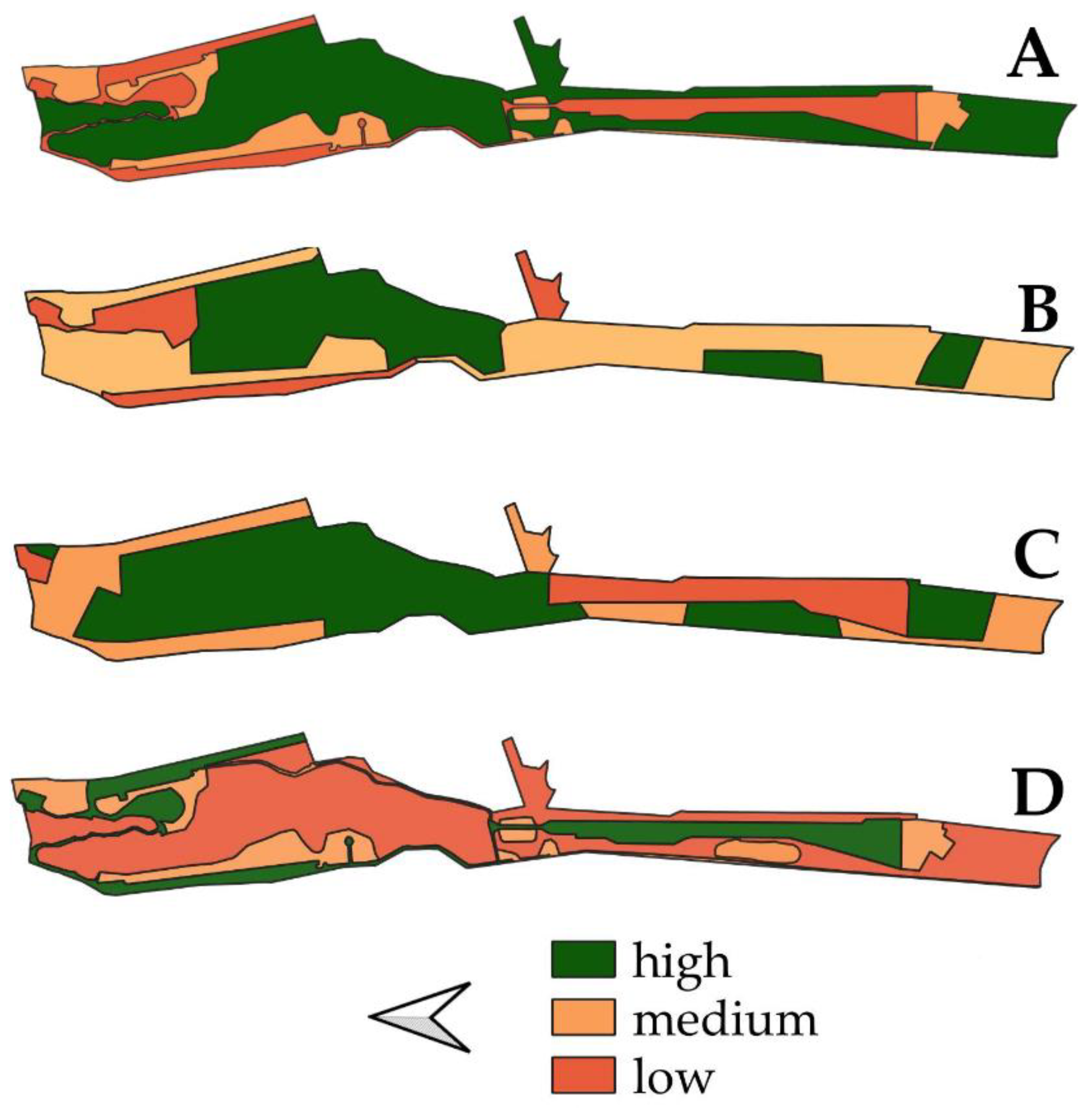
3.2. Participatory Mapping Outcomes

Participatory mapping enabled enrichment by mapping what was observed during the visits and considering the results of the SWOT analysis.
Specifically, four maps were produced: the map of areas with different levels of management/conservation of the case study (question 1); the map of areas subdivided according to the aesthetic value (scenic-perceptual values, question 2); the map of areas with different value from a scientific/educational point of view (question 3); the map of areas that can provide a different level of fruition of the Stellantis–La Mandria site (question 4). All maps show qualitative results, divided into high value; medium value; low value.
The maps (Figure 4) would like to become a tool that allows a correct management and fruition of the site, also indicating the capacity of Stellantis–La Mandria to provide cultural ecosystem services.
With regard to the map of the areas of the case study with different conservation levels (Figure 4A), this means the areas identified by the stakeholders as deserving protection due to their ecological and environmental characteristics and which must be specifically managed. In particular:
-
The ‘high level’ indicates areas where the conservation of ecological characteristics must be maximised and where any management operation must preserve habitats and ensure the survival and reproduction of plant and animal species. The use of natural resources is permitted but must be minimal and sustainable. Research activities are permitted. It is possible to define in future areas with a higher level of protection (e.g., permanent sample plots), similar to an integral nature reserve, where no human activities of any kind are permitted except for scientific research;
-
The ‘low level’ indicates the areas where expert stakeholders consider actions and projects that can change the territory the most possible. However, management must be carried out with a view to the economic and ecological sustainability of the site;
-
The ‘medium level’ indicates areas where it is possible to undertake actions and projects that enhance the ecological/environmental heritage of the site and where research and dissemination activities are promoted. Management in these places should aim at improving the ecological functionality of the habitats present.
With regard to the map of areas subdivided by aesthetic value (Figure 4B), the site was divided into areas with different qualities and perceptions from an aesthetic point of view. In particular:
-
The ‘high level’ indicates the areas where the experts highlighted a higher aesthetic perception;
-
The ‘low level’ indicates the areas where stakeholders have highlighted a minimal aesthetic value, mainly due to the abandonment of structures that do not have valuable architectural and/or construction features;
-
‘The ‘medium level’ indicates the areas that possess appreciable aesthetic characteristics but which are not actually capable of activating the mechanisms of the onset of aesthetic pleasure in the percipient [30].
With regard to the map of areas with different scientific/educational value (Figure 4C), the site was divided into areas that present characteristics, spaces, and buildings useful for the study, understanding and dissemination of the site’s peculiarities at a scientific level. Specifically:
-
The ‘high level’ indicates areas where ecological and environmental features are particularly interesting for study, research, and education. In addition, there are buildings that could be rehabilitated and contribute to the success of numerous scientific and educational activities;
-
The ‘low level’ indicates areas where the natural heritage is not rare or threatened, and man-made areas are not a good example of human intervention in nature. Some research activities related to the evolution of abandoned anthropogenic structures and the presence of plant species can be conducted;
-
The ‘medium level’ indicates areas that can be affected by educational and research projects to improve the ecological functionality of existing habitats.
With regard to the map of areas that can provide a different level of fruition (Figure 4D), the site has been divided into areas that can provide various forms of fruition in the future, highlighting areas where fruition must be minimal to avoid disturbance and damage to the environmental heritage. Guided use is recommended.
Specifically:
-
The ‘high level’ indicates areas where fruition is allowed and promoted and where accessibility could be guaranteed to any type of user;
-
The ‘low level’ indicates the areas where accessibility must be minimal and where access is only guaranteed to park managers, park rangers, or personnel who carry out similar tasks and for scientific research purposes;
-
The ‘medium level’ indicates that fruition can take place for specific activities without disturbing and damaging the local flora and fauna.

4. Discussion

4.1. Fruition and Management Issues in a Private Natura 2000 Site

Cultural ecosystem services, including those related to fruition, recreative, and educational activities, have the characteristic that the place where the service is produced and the place where the benefits can be enjoyed are the same, i.e., in situ [31,32,33]. It should be emphasized that the surrounding landscape plays a key role as a backdrop for in situ experiences [31], and therefore, its proper management is essential to continue to ensure the provision of ecosystem services. These aspects are at the basis of the structuring of our research, which has deepened the management aspects and the perceptual aspects, which cannot be analysed separately but are often strongly intertwined. Consequently, the proposed method is based on on-site visits, SWOT analysis in which there is a discussion between several experts, and a participatory mapping that brings back to the territory (a private Natura 2000 areas, which have seen a reduction in anthropogenic activities) the thoughts, reflections, and experiences of each participant. The main strength of the method lies in its ability to provide a rapid and accurate first insight into management needs and assessments of the provision of cultural ecosystem services, using expert knowledge in combination with GIS data in private Natura 2000 sites. From the overlapping results of the SWOT analysis, it clearly emerges that where the elements of ecological environmental value are relevant, the use needs to be managed with limitations and care. In addition, the SWOT allows to add perceptions and sensory information that a map cannot present. Participatory mapping also confirms the relationship highlighted by the SWOT analysis between management needs and future opportunities for fruition. In the more built-up areas, there are numerous opportunities for future use, extending an important fruition offer close to the urban centres of Venaria and Torino.
During the research carried out in 2020, particular attention was paid to the vegetation component. The main reason is that the area owned by Stellantis still has patches of lowland forest (oak-hornbeam forest), which once covered the entire Po Valley but that now has almost completely disappeared. Specifically, during the visits with the experts, it was possible to observe how the oak-hornbeam forest areas are characterised by the abundance of Carpinus betulus (which covers more than 50% of the areas) and Quercus robur (which covers about 20% of these areas). The presence of Prunus avium and a few specimens of Hedera helix have been recorded, which grow on Carpinus betulus, Quercus robur, and Prunus avium, reaching considerable dimensions in some cases. The undergrowth is characterised by a high presence of Corylus avellana and some plants of Crataegus monogyna. A few specimens of Celtis australis, a species sporadically present in the oak-hornbeam forest, have also been observed. Visits (both online and on site) were therefore essential to proceed with SWOT analysis and participatory mapping. The results of the SWOT analysis about the site management show that the area owned by Stellantis can benefit from a physical delimitation and a low human presence that guarantees a low anthropic pressure on the territory, ensuring the conservation of lowland forest. The shape of the case study and the heterogeneity of environments characterise the site, highlighting a high biodiversity value and performing an important corridor function, connecting to the neighbouring public area [34] as well as being part of a system of protected natural areas in the Turin metropolitan area (Piedmont).
However, at the management level, there is a presence of alien species, in some cases invasive, which have modified the structure of the lowland forest and have invaded (and therefore reduced) open areas (especially grassland). The reason is that management interventions in grassland areas have been sporadic over the years, while the most frequent interventions refer to the woodland area. In this regard, in line with the provisions of the conservation measures for the protection of the Natura 2000 Network in Piedmont [35], silvicultural interventions must be oriented towards the achievement and conservation of a forest structure characterised by greater maturity and a specific composition as close as possible to the natural one. In the Stellantis–La Mandria site, management interventions referred to forest management concerns, trees in wooded areas and trees along paths and trails. As in the public area [34], trees in wooded areas can be subjected to three main management practices: (i) pruning, felling and removal of trees; (ii) standing timber can be sold, especially invasive species, such as Quercus rubra L.; (iii) dead trees are left on the ground or managed as standing dead trees to provide habitat for protected species.
It is underlined that during the visits in the case study, the presence of Lucanus cervus and Cerambix cerdo, ecologically important species, was noted in the wooded areas. Furthermore, in the adjacent public area, the trees in the wooded areas host a rich entomofauna, including Osmoderma eremita (Directive 92/43/EEC), indicating a high species richness as an umbrella species [36]. Monitoring of the entomofauna should therefore also be carried out for years at the Stellantis property site to direct management practices aimed at maintaining a high level of biodiversity. With regard to the trees along the routes and paths, a visual tree assessment (VTA) [37] is carried out, if necessary, with subsequent pruning. In this case, the trees are checked, and the operations performed are monitored. These operations have an important implication and connection with the fruitive activities since a correct stability assessment guarantees access and safer fruition of the areas close to roads and paths. The site Stellantis–La Mandria is characterised by the presence of fauna important to monitor and manage accurately in order to guarantee the use of the site and the protection of the animal component. In particular, in the second part of 2020, the presence of the wolf has been recorded, especially in the public area. This animal is protected at the national and European level, and it is necessary to define a sustainable management model, acquiring data on the presence and evolutionary dynamics of the species.
To ensure a comprehensive and continuous management of the Stellantis site, the results of the participatory mapping (Figure 4A) take into account all the aspects identified by the SWOT analysis and would rather become the tool on which to build an accurate management over time, identifying areas with different management needs, and considering the case study as part of a wider system, which also provides cultural ecosystem services. For aesthetic, educational, and fruitive purposes, as also shown by the results of the related SWOT analysis, the Stellantis–La Mandria site has the potential to become an important destination from a fruitive and educational point of view, thanks to its natural heritage, where different forms of recreation can evolve and develop around the natural attractions embedded in the ecosystem. The ability of areas to provide cultural ecosystem services, including aesthetic, educational, and recreational ones, depends on the presence of biophysical features [38], and their spatial distribution and accessibility. The accessibility is one of the strengths of the case study that can be used by cars, by other means of transport, and by people with disabilities to reach different points of the site. Areas with easy accessibility might have a greater potential to provide some cultural ecosystem services than areas with more difficult access [39]. This is partly demonstrated by Figure 4D, which shows that areas characterised by the presence of a structured road system were the most suitable for the future use of the site. However, these areas do not always present high levels of SE provision linked to aesthetic appreciation (Figure 4B). Nevertheless, the choice of selected areas by experts is associated with the benefit obtained from the provision of cultural ecosystem services in those places, although it is necessary to highlight the complexity of the links between well-being, historical/cultural values, ecosystem services, and preferred places [40]. The proximity of an area of high natural value, to urban and peri-urban contexts is linked to the hope that people will eventually be persuaded not to travel long distances to experience ‘wild’ areas with a high natural value, which favours incredible recreational and educational opportunities [41].
Among the recreational/educational activities to be proposed within the case study (Figure 4D), which emerged during various discussions with experts, particular importance could be given to: sports activities and activities promoting physical and mental wellbeing (e.g., running; nordic walking; meditation; forest bathing); scientific activities (Figure 4C, e.g., establishment of a university study centre; establishment of a forestry study centre; educational activities (guided tours; nature walks; creation of a forest school and/or an environmental education centre, birdwatching activities); artistic activities (painting, photography, woodcarving courses). At the basis of the educational and fruitive activities there should be a large space for communication activities. It might be useful to provide specific posters, brochures, and other information material on the Natura 2000 network, highlighting its ecological value and vulnerabilities.

4.2. Limitation of the Study

It should be noted that scientific information on habitats, species, and naturalistic emergencies is currently partial, and the level of detail varies from one aspect to another. During the surveys carried out in 2020, it was possible to acquire information necessary for drawing maps on the management/conservation and fruition of the area, but it was certainly not possible to fill many gaps in knowledge, which can only be explored with a systematic survey and monitoring programme. There is, therefore, a need to expand the specific knowledge of the sites and of the habitats and species of community interest through targeted studies and monitoring activities. These maps, and in particular Figure 4, will be useful in setting up site monitoring and management activities over a few years. During this time, it is necessary to collect sufficient data to confirm the validity of the proposed maps, and if necessary, to make specific modifications or implementations. Management practices should undergo a specific management effectiveness evaluation [42], which is generally achieved through the assessment of a set of criteria, represented by carefully selected indicators against identified and/or agreed objectives. In any case, the involvement of various stakeholders and experts is always necessary to ensure management effectiveness, which must concern design issues related to both the individual site and the protected area system; the adequacy and appropriateness of management systems and processes; and the achievement of the protected area objectives. Examples of public/private management coordination of SAC sites are few. The research is therefore intended as a pilot case, providing qualitative results, and it will have to be implemented by involving further stakeholders.

5. Conclusions

The results of the research aim to meet some of the European Commission’s requirements for Natura 2000 sites, which indicate that the involvement of different stakeholders and experts in these areas is crucial for the conservation of biodiversity, integrating ecological and social aspects into management and use plans. The intention of the study was to provide an introductory survey to assess a more accurate management of the areas of a private Natura 2000 site and its provision of cultural ecosystem services (including the potential for fruition) involving experts. The proposed methodology should be continued over time to gather more information, while involving more stakeholders, with the aim of assessing the provision of other ecosystem services and co-designing a management and use plan. This is because the management of green areas and Natura 2000 sites requires a multi-stakeholder approach and needs to be approached from a socio-ecological perspective, seeking to protect the natural characteristics of a site while enhancing human well-being [43]. Furthermore, user perceptions, if integrated into the decision-making process, can lead to the resolution of conflicts between the wishes of users and the needs of the managers of an area to positively improve user attitudes towards conservation measures [44].
As mentioned in the previous sections, the research and the methodologies adopted have produced concrete results with the aim of returning a newly usable space to the population in the short term. The results of the research were particularly appreciated by the public body, which will include them in the new area plan of all the SAC sites, which dictates the rules to be followed in both the public and private areas.
In conclusion, Natura 2000 sites in urban and peri-urban contexts, including private areas, must fulfil two main requirements: to be a protected area with great ecological characteristics; to provide services (tourist facilities, cultural and recreational activities) that allow full enjoyment during visits. It would be interesting to analyse in future studies the provision and perception of ecosystem disservices provided by these areas.

Author Contributions

Conceptualization, L.B. and M.D.; methodology, L.B.; software, L.B.; validation, L.B., F.L. and M.D.; formal analysis, L.B.; investigation, L.B.; resources, L.B.; data curation, L.B.; writing—original draft preparation, L.B., F.L., S.G., N.D.B. and M.D.; revision of the manuscript, L.B., M.D. and F.L.; funding acquisition, L.B., F.L., N.D.B. and M.D. All authors have read and agreed to the published version of the manuscript.

Funding

This research was funded by FONDAZIONE CRT and FONDAZIONE GORIA—Borsa di Ricerca Bando Talenti della Società Civile Edizione 2019.

Institutional Review Board Statement

Not Applicable.

Informed Consent Statement

Not Applicable.

Data Availability Statement

Not Applicable.

Acknowledgments

We would like to thank all the experts and stakeholders for their contributions in carrying out this research.

Conflicts of Interest

The authors declare no conflict of interest.

References

  1. European Commission. 2018. Available online: http://ec.europa.eu/environment/nature/natura2000/index_en.htm (accessed on 8 April 2021).
  2. European Environment Agency. 2018. Available online: https://www.eea.europa.eu/data-and-maps/dashboards/natura-2000-barometer (accessed on 9 April 2021).
  3. SIC, ZSC e ZPS in Italia. Available online: https://www.mite.gov.it/pagina/sic-zsc-e-zps-italia (accessed on 21 February 2022).
  4. Soga, M.; Gaston, K.J. The ecology of human–nature interactions. Proc. R. Soc. B 2020, 287, 20191882. [Google Scholar] [CrossRef] [PubMed] [Green Version]
  5. Pietrzyk-Kaszyńska, A.; Cent, J.; Grodzińska-Jurczak, M.; Szymańska, M. Factors influencing perception of protected areas—The case of Natura 2000 in Polish Carpathian communities. J. Nat. Conserv. 2012, 20, 284–292. [Google Scholar] [CrossRef]
  6. European Commission. Natura 2000 and Forest Part I–II. 2015. Available online: http://ec.europa.eu/environment/nature/natura2000/management/docs/Final%20Guide%20N2000%20%20Forests%20Part%20I-II-Annexes.pdf (accessed on 16 April 2021).
  7. European Commission 2018. Managing Natura 2000 Sites. The Provisions of Article 6 of the ‘Habitats’ Directive 92/43/EEC. Available online: http://ec.europa.eu/environment/nature/natura2000/management/docs/art6/Provisions_Art_._nov_2018_endocx.pdf (accessed on 18 April 2019).
  8. Beunen, R.; de Vries, J.R. The governance of Natura 2000 sites: The importance of initial choices in the organisation of planning processes. J. Environ. Plan. Man. 2011, 54, 1041–1059. [Google Scholar] [CrossRef]
  9. Paletto, A.; Graziani, A.; Brescancin, F.; De Meo, I. Public participation in the implementation of the Natura 2000 network in Italy: The stakeholders’ experiences. IForest 2017, 14, 13–27. [Google Scholar] [CrossRef] [Green Version]
  10. Nastran, M. Why does nobody ask us? Impacts on local perception of a protected area in designation, Slovenia. Land Use Policy 2015, 46, 38–49. [Google Scholar] [CrossRef]
  11. Jones, N.; Malesios, C.; Ioannidou, E.; Kanakaraki, R.; Kazoli, F.; Dimitrakopoulos, P.G. Understanding perceptions of the social impacts of protected areas: Evidence from three NATURA 2000 sites in Greece. Environ. Impact Assess. Rev. 2018, 73, 80–89. [Google Scholar] [CrossRef]
  12. Lischka, S.A.; Teel, T.L.; Johnson, H.E.; Reed, S.E.; Breck, S.; Carlos, A.D.; Crooks, K.R. A conceptual model for the integration of social and ecological information to understand human-wildlife interactions. Biol. Conserv. 2018, 225, 80–87. [Google Scholar] [CrossRef] [Green Version]
  13. Sarvašová, Z.; Ali, T.; Đorđević, I.; Lukmine, D.; Quiroga, S.; Suárez, C.; Hrib, M.; Rondeux, J.; Mantzanas, K.T.; Franz, K. Natura 2000 payments for private forest owners in Rural Development Programmes 2007–2013—A comparative view. For. Policy Econ. 2019, 99, 123–135. [Google Scholar] [CrossRef]
  14. Sarvašová, Z.; Quiroga, S.; Suárez, C.; Ali, T.; Lukmine, D.; Đorđević, I.; Hrib, M. Understanding the drivers for Natura 2000 payments in forests: A Heckman selection analysis. J. Nat. Conserv. 2018, 46, 28–37. [Google Scholar] [CrossRef]
  15. Witkowski, J. Investment Activity and Nature Conservation in Private Natura 2000 Sites in Poland—A Case Study. Pol. J. Environ. Stud. 2021, 30, 4781–4788. [Google Scholar] [CrossRef]
  16. Tiebel, M.; Mölder, A.; Plieninger, T. Small-scale private forest owners and the European Natura 2000 conservation network: Perceived ecosystem services, management practices, and nature conservation attitudes. Eur. J. For. Res. 2021, 140, 1515–1531. [Google Scholar] [CrossRef]
  17. Laktić, T.; Pezdevšek Malovrh, Š. Stakeholder Participation in Natura 2000 Management Program: Case Study of Slovenia. Forests 2018, 9, 599. [Google Scholar] [CrossRef] [Green Version]
  18. Gil, A.; Calado, H.; Costa, L.T.; Bentz, J.; Fonseca, C.; Lobo, A.; Vergilio, M.; Benedicto, J. A Methodological Proposal for the Development of Natura 2000 Sites Management Plans. J. Coast. Res. 2011, 64, 1326–1330. [Google Scholar]
  19. Queiroz, R.E.; Ventura, M.A.; Silva, L. Plant diversity in hiking trails crossing Natura 2000 areas in the Azores: Implications for tourism and nature conservation. Biodivers. Conserv. 2014, 23, 1347–1365. [Google Scholar] [CrossRef]
  20. Tsiafouli, M.A.; Apostolopoulou, E.; Mazaris, A.D.; Kallimanis, A.S.; Drakou, E.G.; Pantis, J.D. Human Activities in Natura 2000 Sites: A Highly Diversified Conservation Network. Environ. Manag. 2013, 51, 1025–1033. [Google Scholar] [CrossRef]
  21. Schirpke, U.; Scolozzi, R.; Da Re, R.; Masiero, M.; Pellegrino, D.; Concetti, B.; Marino, D. Recreational ecosystem services in protected areas: A survey of visitors to Natura 2000 sites in Italy. J. Outdoor Recreat. 2018, 21, 39–50. [Google Scholar] [CrossRef]
  22. Martini, U.; Buffa, F.; Notaro, S. Community Participation, Natural Resource Management and the Creation of Innovative Tourism Products: Evidence from Italian Networks of Reserves in the Alps. Sustainability 2017, 9, 2314. [Google Scholar] [CrossRef] [Green Version]
  23. Parco Nazionale Dolomiti Bellunesi: SCI and SPAs Management Plan. Available online: https://www.dolomitipark.it/en/park-authority/the-park-master-plan/sci-and-spas-management-plan/ (accessed on 21 February 2022).
  24. European Commission. Guidelines on Wilderness in Natura 2000. 2013. Available online: http://ec.europa.eu/environment/nature/natura2000/wilderness/pdf/WildernessGuidelines.pdf (accessed on 16 April 2021).
  25. Kati, V.; Hovardas, T.; Dieterich, M.; Ibisch, P.L.; Mihok, B.; Selva, N. The challenge of implementing the European network of protected areas Natura 2000: Implementing Natura 2000. Conserv. Biol. 2015, 29, 260–270. [Google Scholar] [CrossRef] [Green Version]
  26. Braun, R.; Amorim, A. Rapid ‘SWOT’ Diagnosis Method for Conservation Areas. Scott. Geogr. J. 2015, 131, 17–35. [Google Scholar] [CrossRef]
  27. Ramirez-Gomez, S.O.I.; Brown, G.; Fat, A.T.S.A. Participatory mapping with indigenous communities for conservation: Challenges and lessons from Suriname. Electr. J. Inf. Syst. Dev. Countr. 2013, 58, 1–22. [Google Scholar] [CrossRef] [Green Version]
  28. Darvill, R.; Lindo, Z. Quantifying and mapping ecosystem service use across stakeholder groups: Implications for conservation with priorities for cultural values. Ecosyst. Serv. 2015, 13, 153–161. [Google Scholar] [CrossRef]
  29. Costanza, R.; de Groot, R.; Braat, L.; Kubiszewski, I.; Fioramonti, L.; Sutton, P.; Farber, S.; Grasso, M. Twenty years of ecosystem services: How far have we come and how far do we still need to go? Ecosyst. Serv. 2017, 28, 1–16. [Google Scholar] [CrossRef]
  30. Galetta, G. Elementi di precognizione estetica: Risultati di un esperimento di percezione estetica condotto su Facebook. Psychofenia 2016, 34, 13–54. [Google Scholar]
  31. Fisher, B.; Turner, R.K.; Morling, P. Defining and classifying ecosystem services for decision making. Ecol. Econ. 2009, 68, 643–653. [Google Scholar] [CrossRef] [Green Version]
  32. Syrbe, R.U.; Walz, U. Spatial indicators for the assessment of ecosystem services: Providing, benefiting and connecting areas and landscape metrics. Ecol. Indic. 2012, 21, 80–88. [Google Scholar] [CrossRef]
  33. Kulczyk, S.; Woźniak, E.; Derek, M. Landscape, facilities and visitors: An integrated model of recreational ecosystem services. Ecosyst. Serv. 2018, 31, 491–501. [Google Scholar] [CrossRef]
  34. Battisti, L.; Corsini, F.; Gusmerotti, N.M.; Larcher, F. Management and Perception of Metropolitan Natura 2000 Sites: A Case Study of La Mandria Park (Turin, Italy). Sustainability 2019, 11, 6169. [Google Scholar] [CrossRef] [Green Version]
  35. Misure di Conservazione per la Tutela Della Rete Natura 2000 del Piemonte. Available online: https://www.regione.piemonte.it/web/temi/ambiente-territorio/biodiversita-aree-naturali/rete-natura-2000/piani-gestione-misure-conservazione (accessed on 23 September 2021).
  36. Ranius, T.; Aguado, L.O.; Antonsson, K.; Audisio, P.; Ballerio, A.; Carpaneto, G.M.; Chobot, K.; Gjurasin, B.; Neculiseanu, Z. Osmoderma eremita (Coleoptera, Scarabaeidae, Cetoniinae) in Europe. Anim. Biodivers. Conserv. 2005, 28, 1–44. [Google Scholar]
  37. Mattheck, C.; Breloer, H. Field guide for Visual Tree Assessment (VTA). Arboric. J. 1994, 18, 1–23. [Google Scholar] [CrossRef]
  38. Chhetri, P.; Arrowsmith, C. GIS-based Modelling of Recreational Potential of Nature-Based Tourist Destinations. Tour. Geogr. 2008, 10, 233–257. [Google Scholar] [CrossRef]
  39. Ruskule, A.; Klepers, A.; Veidemane, K. Mapping and assessment of cultural ecosystem services of Latvian coastal areas. One Ecosyst. 2018, 3, e25499. [Google Scholar] [CrossRef]
  40. Ridding, L.E.; Redhead, J.W.; Oliver, T.H.; Schmucki, R.; McGinlay, J.; Graves, A.R.; Morris, J.; Bradbury, R.B.; King, H.; Bullock, J.M. The importance of landscape characteristics for the delivery of cultural ecosystem services. J. Environ. Manag. 2018, 206, 1145–1154. [Google Scholar] [CrossRef] [PubMed] [Green Version]
  41. Rink, D.; Emmrich, R. Surrogate Nature or Wilderness? Social Perceptions and Notions of Nature in an Urban Context. In Wild Urban. Woodlands; Kowarik, I., Körner, S., Eds.; Springer: Cham, Switzerland, 2005; pp. 1–299. [Google Scholar]
  42. IUCN—Management Effectiveness Evaluation in Protected Areas—A Global Study. Available online: https://www.iucn.org/content/management-effectiveness-evaluation-protected-areas-a-global-study (accessed on 23 September 2021).
  43. Battisti, L.; Pille, L.; Wachtel, T.; Larcher, F.; Säumel, I. Residential Greenery: State of the Art and Health-Related Ecosystem Services and Disservices in the City of Berlin. Sustainability 2019, 11, 1815. [Google Scholar] [CrossRef] [Green Version]
  44. Vodouhê, F.; Coulibaly, O.; Adégbidi, A.; Sinsin, B. Community perception of biodiversity conservation within protected areas in Benin. For. Policy Econ. 2010, 12, 505–512. [Google Scholar] [CrossRef]
Figure 1. Location of the Stellantis–La Mandria study area within the site, ‘ZSC IT1110079 La Mandria’, in the northwest area of the metropolitan city of Turin.
Sustainability 14 03134 g001
Figure 2. Forest land uses of the Stellantis–La Mandria site.
Sustainability 14 03134 g002
Figure 3. Methods applied to achieve the objectives.
Sustainability 14 03134 g003
Figure 4. Classification of the Stellantis–La Mandria site according to levels of: (A) management/conservation needs; (B) aesthetic value of the case study; (C) scientific/educational values; (D) opportunity of fruition.
Sustainability 14 03134 g004
Table 1. SWOT analysis on the management of the natural (ecological/environmental) heritage of the Stellantis–La Mandria site.
Positive FactorsNegative Factors
Internal FactorsStrengths:
Physical delimitation;
Low human presence;
Quality and diversity of heritage;
Corridor function;
High biodiversity potential;
Extent of the site;
Area adjacent to the public park area;
Heterogeneity of environments;
Presence of species in the Habitats Directive (Annex II and IV);
Lowland forest.
Weaknesses:
Presence of invasive alien species;
Presence of structures, bituminous surfaces, guardrails;
Hydroelectric power plant;
Presence of alien species;
Extent of the site (management difficulties);
Dispersion of resources;
Lack of environmental/naturalistic data;
Invasion (and thus reduction) of open areas (especially grassland);
Long and narrow surfaces.
External FaccctorsOpportunities:
Marketing for environmental investments;
Proximity to urban areas;
Possible interest of external partners;
Studies and research;
Collaboration for proper management (Habitats Directive);
Recovery of anthropogenic elements;
Recovery of former agricultural areas;
Biodiversity census.
Threats:
Hydroelectric plant management interventions;
Improper fruition management;
Incorrect biodiversity value management interventions;
Bureaucracy;
Further expansion of plant species and degradation of environments;
Reduced resilience due to lack of management;
Loss of biodiversity.
Table 2. SWOT analysis of possibilities of fruition (outdoor recreation and tourism) of the Stellantis–La Mandria site.
Positive FactorsNegative Factors
Internal FactorsStrengths:
Extremely varied natural environment;
Consolidated path network (also valid for rescue);
Scarce anthropisation (e.g., importance of darkness);
Structures and history of the places;
Proximity to a wide range of users;
High degree of naturalness;
Abundant fauna presence;
Presence of plant species linked to the local culinary tradition.
Weaknesses:
The water network is of artificial derivation (therefore subject to maintenance needs and draining);
Presence of allochthonous species;
Extensive presence of asphalt;
Ungulate fauna to be managed/contained;
Precarious infrastructure conditions;
Lack of services, such as cycle paths, public transport, etc.;
Difficult to differentiate from other parks;
High costs for the re-use of some areas/facilities;
Pathologies of some animals, mainly deer.
External FaccctorsOpportunities:
Reduction of allochthonous species through cultivation systems (e.g., Solidago spp. in grassland areas);
Eco-tourism;
The asphalt also favours accessibility for the disabled;
Proximity to the Turin metropolis;
Area of interest for associations, sports groups, etc.;
Possibility of creating routes for fruition;
Possibility of creating accommodation facilities;
Breeding/educational farm for cultural purposes;
Nature monitoring and science centre.
Threats:
Unguided fruition and related wrong actions;
The security to be guaranteed for unguided use which may impose a reduction in naturalness;
Proximity to the Turin metropolis (also a threat);
Competition of other nearby parks;
Not ‘eco-sustainable’ fruition;
Climate change;
Damage from wildlife.
Publisher’s Note: MDPI stays neutral with regard to jurisdictional claims in published maps and institutional affiliations.

