
A Place under the Sun: Planning, Landscape and Participation in a Case of a Solar Powerplant in the Israeli Desert


Department of Geography and Environmental Development, Ben-Gurion University of the Negev, Beer-Sheva 8410501, Israel
*
Author to whom correspondence should be addressed.
Sustainability 2022, 14(13), 7666; https://0-doi-org.brum.beds.ac.uk/10.3390/su14137666
Submission received: 27 May 2022
/
Revised: 6 June 2022
/
Accepted: 22 June 2022
/
Published: 23 June 2022
(This article belongs to the Special Issue Renewable Energy Technologies and Environmental Impact Assessment)
Abstract
:Studies demonstrate the lack of common interpretations and rigorous methods for landscape assessments (LA) during design and siting of renewable energy (RES) facilities. Research shows how perceived landscape impacts influence public willingness to accept changes in the landscape. The connection between the effectiveness of LA procedures vis-à-vis the inclusion of the public in decision-making related to RES siting has received less attention. We, therefore, examine the role of LAs in planning via the eyes of policymakers and experts, and evaluate the capacity of current tools to influence the process. Additionally, we analyze the role (or lack thereof) of the public in LAs. Our unique case—one of the largest in the world thermo-solar “tower” plant, located near a small desert village—exemplifies the place for landscape consideration in national-level mega-infrastructure. Based on documents analysis and semi-structured interviews, the findings demonstrate the struggle between competing goals such as financial and temporal efficiency, RES targets, landscape protection, and public participation. We conclude that first, despite independent efforts to promote the latter two, there may be little connection between the assessment of landscape effects and public participation because there is no mechanism for post-evaluation of a project’s impacts, and any debates on the actual effects remain theoretical. Second, that landscape impacts of large-scape infrastructure can mainly be avoided in the stage of site location, and at this stage, the room for public input remains limited.
1. Introduction
In recent decades, there is a notable trend towards reliance on renewable energies (RES), especially wind and solar, replacing the traditional use of conventional production facilities based on fossil fuels. The main drivers of the transition to low carbon, renewable-rich electricity systems are the desire to slow the acceleration of the global warming crisis by reducing greenhouse gas emissions and meet Sustainable Development Goal (SDG) #7, to “ensure access to affordable, reliable, sustainable and modern energy” to all. Yet these methods, particularly solar energy, require much more land than conventional coal or natural gas power generation. As a result, terrestrial solar installations compete with other land-uses worldwide [1,2,3].
Among general ecological and environmental impacts, the decarbonization of energy production has visual and landscape impacts. While scenic consequences are an anthropocentric concern and might be overridden by considerations concerning climate change and air pollution, they have been found to play a major role in public acceptance of RES and are increasingly a reason behind public objections to projects [4,5]. Yet, decision-makers usually prioritize matters of short-term efficiency and costs over the landscape impact of RES [4]. It has, therefore, been argued that for a successful energy transition, it will be crucial to harness public support for the necessary landscape changes [6], a goal which might not be achieved without actually taking landscape more seriously during the stages of RES design, planning, and installation. Still, the connection between the effectiveness of LA procedures vis-à-vis the inclusion of the public in decision-making related to RES siting has not received much attention.
Indeed, despite the recognition that energy transition is important, conflicts arise between policy makers and stakeholders, and between different interests in the process of RES siting [7,8]. This requires that RES development be considered in spatial planning policy that considers these conflicts and addresses them adequately, alongside a continuous quest for “smart practices” in siting-related decisions [9]. Studies highlight the impact of national regulation and local planning procedures on the speed and successful implementation of renewable energy projects [10], Specifically, it is claimed that complex regulations and lengthy approval processes that require substantial environmental and landscape impact assessments constitute barriers to an effective planning [11]. Research further indicates that there is a need for unique place-based planning approaches to promote the creation of culturally distinct “energy landscapes” that are aligned with local perceptions and values, and, therefore, can gain support for the optimal combination of the necessary infrastructure [12,13].
The goal of the current study is, therefore, to examine the role of landscape assessments (LA) in planning processes of RES through the eyes of decision-makers and professionals and to question the capacity of current planning channels and tools to have significant influence on siting and design processes for such projects. Additionally, we analyze the role (or lack thereof) of residents and the general public in LAs, during the plan’s appraisal and approval stages, as perceived by decision-makers. Our specific case study exemplifies the place of landscape considerations in national-level, mega-infrastructure. Such projects may demonstrate the continuous struggle between competing goals such as financial and temporal efficiency, achieving RES targets, landscape protection, and public participation that can, to some extent, be linked to the institutional regulatory framework of large-scale infrastructure promoted by a centralized planning system and through Public-Private Partnerships (PPP). We turn now to examine the interplay of RES planning, Landscape Assessments, and participation, using the decade-long planning procedure of a solar “tower” near the village Ashalim, Israel, as case study, preceded by a review of the relevant literature and a description of the methods used in the current study.
2. Theoretical Background
2.1. A Brief Background on Landscape Assessments in Land-Use Planning: Definitions, Tools and Limitations
Landscape assessment is an important component in environmental and land-use management procedures [14]. The main methods of LA were developed in England and include the Landscape Character Assessment (LCA), which is “the process of identifying and describing variation in the character of the landscape. It seeks to identify and explain the unique combination of elements and features (characteristics) that make landscapes distinctive” [15] (p. 8). The landscape aspect reflects the complexity of combining planning considerations with sustainable local and regional development in practice [16,17]. Part of this complexity is the mere definition of “landscape”; the literature contains diverse meanings in many disciplines, including cultural geography, art history, landscape architecture, environmental studies, archeology, sociology, and anthropology. By the 1970s, the landscape was portrayed as a “complete spatial-visual entity” within a human living-space, a space that combines the geosphere and biosphere with man-made products. The theory of “landscape ecology” later bridged the gap between the spatial-geographical approach emphasizing the geomorphological traits of a region and the ecological approach of anthropogenic land use. Certainly, a critical point in the current theorization is recognizing the crucial role of humans in landscape design and the ecological implications of our actions [18]. This approach has been reinforced by the work by UNESCO on the World Heritage Convention that, in 1992, became the first international legal instrument to recognize and protect “cultural landscapes”.
Beyond the limited list of sites protected by the UN, the realm of planning includes a wide range of methods and tools for identifying and analyzing landscape impacts of proposed development projects [19]. Overall guidance presented by the European Landscape Convention (ELC) aims to promote the protection, planning, and management of landscapes [20]. It defines the landscape as “a zone or area as perceived by local people or visitors, whose visual features and character are the result of the action of natural and/or cultural (that is, human) factors”. The European signatory states undertake to assess the identity of landscapes in light of the specific appreciation modes, perceptions, and values, attributed to the people who experience it, but the large number of state parties means that there is a wide range of historical and cultural approaches to the term. The variety of meanings attributed to the words for “landscape” in different languages raises questions about its universal meaning in the context of scholarship [21,22]. Studies show that differences in understanding the concept of “landscape” can result in diverse approaches to implementing the convention (e.g., [23,24]), as well as communication gaps within and between countries, particularly concerning the application of LAs and their enforcement by national legislation (e.g., [25]). Furthermore, while some countries signed the convention but have not developed national legislation to enforce it [26], other countries might well require additional adjustments of environmental planning principles to local political, cultural, and regulatory framing conditions [27]. According to the comprehensive review conducted by [25], the lack of consistency in LA approaches and techniques, and the shortage of data, are prime weaknesses in the process (see also [28]).
2.2. Energy Landscapes: LCA, the Regulatory Framework and Public Participation
In European countries, landscape changes caused by the construction of large, significantly impactful infrastructure projects are examined using an Environmental Impact Assessment (EIA), which defines landscape impact as the ecological, social, and cultural implications of a given project, stressing the importance of examining the landscape, as “a resource in itself,” rather than a “theater set”. This analysis can also be performed as part of a Strategic Environmental Assessment (SEA), providing data on the most suitable location for the construction of projects [29,30]. In the USA, a Visual Impact Assessment is required as part of the National Environmental Policy Act of 1969 (NEPA), but only for major federal actions on public land. NEPA includes a detailed classification of landscape quality criteria, including visual quality, visibility, visual magnitude, and visual impact [31,32]. In Israel, there is no legally binding instrument for conducting landscape assessments, but LCA has been embraced by planners and embedded de facto in land-use plans since the 1980s when awareness of the threat to the country’s ecological and landscape diversity due to its rapid population growth increased [28].
The literature presents various approaches as to how society should be dealing with transformations of valued landscapes in the face of the climate crisis and increased public rejection of RES, such as wind and solar farms, in rural areas or the built environment. Several essential criteria for examining RES infrastructure projects include the attempt to quantify the visual effects of shape, color, visibility, and size of the facilities in order to define “suitable” constellations in particular landscapes [33]. Yet, as mentioned above, existing characterizations for landscape analyses do not include defined values or indicators but only reference points that are hard to measure. For example, according to [34], out of 44 infrastructure projects examined in Italy, only 29 had documentation for the complete landscape analysis and of these, only two analyzed both perceptual and aesthetic factors. Specifically, researchers lamented the lack of common interpretations and rigorous scientific methods for aesthetic-perceptual assessments during both the technological design and the planning stages of renewable energy projects [32,35,36].
According to the EU Convention (ELC), aesthetic (sense/judgment of impact) and perceptual (e.g., visibility) aspects of the landscape should be examined in combination. Accordingly, researchers assert that the considerations for the location of RES infrastructure should also include an examination of local tradition and “landscape culture”. One of the main arguments in this regard is that visual impact is a major impediment to obtaining public consent for RES plans [37]; from a more positive perspective, it is hoped that their design can be combined more harmoniously with the environment in such a way that it will even add “new cultural features” to the landscape [13,38].
Some scholars have, therefore, highlighted the cruciality of knowledge and information for public acceptance of RES [39,40], and of public involvement in decision-making that assesses local values of specific landscapes [41,42]. Specifically, it is widely agreed that subjective appraisal is intrinsic to the process and that planners should strive to show how landscapes are perceived, experienced, and valued by humans. Another important factor influencing acceptance is appropriate financial compensation [43,44]. Albeit not without criticism concerning the intrinsically non-democratic nature of current planning institutions [45], public participation in EIA has been institutionalized and formalized to varying degrees and forms in different countries (for a review see [46]), with the intention of achieving broader goals and improving effectiveness, legitimacy, and trust in planning processes [47,48]. This, however, may require a set of concepts and tools for grasping the complex ties between non-expert individuals and locales [5]. The need to consider the perceptions of local residents in any landscape intervention was already emphasized in the ELC, but in actual practice, public participation in landscape assessments often remains limited to consultation, as cross-country comparisons have repeatedly shown [49,50]. Participation is limited to one-way information sharing and is primarily aimed at creating legitimacy for the project [51], even though numerous studies on land-use planning of RES projects highlight the advantages of public involvement in landscape appraisals and site-selection. Moreover, [52] has emphasized the irreplaceability of landscape characteristics, suggesting that, “rather than merely engaging stakeholders in a process where they can express their (pre-conceived) set of preferences and include those preferences in siting decisions, we should start thinking about community engagement as a process that permits preferences to be formed and adjusted” (p. 723). This entails a kind of an active discussion, wherein stakeholders get the opportunity to not only express their concerns about landscape change, but to adjust or modify their views, or even to choose a completely new narrative over another, for example, one that expresses an appreciation of the new “energy landscape,” rather than being intimidated by it (see also [13,53]). We adopt a definition by [17] of energy landscape, referring to landscape transformations that occur as a result of societal energy demands.
In the following section, we describe the specific energy landscape examined by the current study, and outline the methods used to gather and analyze data, including relevant background information on the local planning system and specifics of the case-study. In Section 4, we present and describe the findings; and in Section 5, discuss and conclude.
3. Materials, Methods and Case-Study
This study uses an in-depth case-study approach, focusing on a thermo-solar tower RES facility near the village Ashalim, Israel (also known as “Plot B”). The collection of data consisted of obtaining and analyzing dozens of documents and protocols from the long planning process (2002–2013), as well as semi-structured in-depth interviews. The documents include governmental decisions, planning committee protocols, environmental reports, policy papers, and land-use maps (a list of key documents can be found in Appendix A). Additionally, the first author conducted 11 semi-structured interviews with key stakeholders who participated actively in the longitudinal decision-making and planning process. The interviews were conducted virtually or by telephone, due to COVID-19, during 2020–2021, and each lasted between 45 and 90 min. They were recorded and transcribed. The identification of relevant people was made based on the first stage of the study that focused on documents and protocols analysis. Interviewees included key actors in governmental authorities that led the planning of the facility and managed its ecological-environmental aspects, namely representatives from the following organizations: the Ministry of Environmental Protection, the Natural Parks Authority, the Southern District Planning Committee, the regional council, and the Society for Protection of Nature (an NGO with voting rights on planning committees). An additional five interviewees were private or freelance environmental advisors and landscape architects who conducted the EIA for this specific project.
The questions in the interviews focused on the main research interests: what did key actors think were the implications of the mega-RES plan for the desert landscape?; Were these implications considered appropriate (in terms of time and depth) during the planning process?; Did the stakeholders think that they had suitable tools and procedures for evaluating the magnitude of impact?; Were there any specific regulatory institutional conditions that had determinative impact on their ability to conduct the LA and implement its findings (regarding, for example, the PPP structure of the project, the national-level planning where it took place, etc.)? Finally, we asked if there was a room for public involvement in the process and what did it contribute to the landscape assessment. The documents, protocols, and transcripts of the interviews were analyzed thematically, inspired by grounded theory, where themes emerge through interpretation of data. The procedure consisted of coding the texts, merging codes under potential subthemes, and comparing the emergent coding clusters with each other and in relation to the full data set as well as to findings of existing scientific literature on the topic.
Background: The Thermo-Solar Tower in Ashalim, Israel (“Plot B”) and Its Planning Process
In the absence of potential for producing renewable energy from hydroelectric and geothermal sources, and having negligible wind resources, the Israeli government’s renewable energy policy is mostly based on solar production facilities (see Table 1). A number of socio-spatial characteristics, however, pose a challenge to increasing the share of terrestrial solar production in the country’s energy mix, such as the lack of grid connection with neighboring countries, rapid increase in demand, and underdeveloped transmission lines that could transmit electricity produced by RES from potential large-scale production sites to more populated districts. Additionally, political-institutional disagreements and frictions have resulted in unstable coalitions around policy design alternatives, hindering RES proliferation [54]. Finally, the land in Israel, 93% of which is public, is subject to two significant, parallel, and often incompatible regulations: the Statutory Planning Regulation and the Land Regulation. The Statutory Planning Regulation is based on the Planning and Building Law, national, district, and local planning policies, descriptive plans, and detailed plans. The Land Regulation is based mainly on the Israel Land Law and the decisions of the Israel Land Authority (ILA), which administers the publicly owned lands [55]. This twofold regulatory system prolongs and burdens the approval process because both the ILA and planning committees must approve most land-based RES projects in open areas [56]. In the case under consideration here, the State owns the land and also initiated the plan, which it decided to finance through a Public–Private Partnership arrangement.
The thermo-solar project in Ashalim or “Plot B” is the first, and to date the largest, solar energy facility that has been installed in Israel; indeed, it is one of the largest of this type globally. Located in the Negev (the arid desert region in the south of the country), it is based on concentrating thermal solar power (CSP) technology and includes 50,600 computer-controlled heliostats covering an area of 3 km2 on a 240-m-high tower, (see Figure 1 and Figure 2).
The statutory planning process started in 2002 with a search for alternative sites, and the location was approved by the National Planning and Building Board (NPBB) in 2004 (Figure 2). In parallel to the siting process, a Built-Own-Transfer (BOT) tender was issued by the State, with a target of 121 MW solar power capacity but without specifications for the preferred technology. The planning procedure was transferred to the Principle Planning Issues (PPI) sub-committee of the National Planning and Building Council (NPBC), which deals with planning issues that are considered too substantive for the main body of the NPBC. An EIA on several different plans and technologies (thermo-solar and PV) around the Ashalim site (Maps 2) was submitted in November 2011 and was approved after corrections in April 2012. Following the environmental assessment, the committee recommended approving the plan subject to modifications, stating that it is impressed “by the scope of the program, its complexity and its importance in achieving the goals of production of electricity from renewable energy” (PPI protocol, 15 May 2012). In 2013, the land-use of the site was redesignated from a military zone to solar energy facilities by statutory National Outline Plan (NOP) 10/B/1. Yet, six more years passed before the power station became operational. The long duration of the planning processes, together with the national targets of renewables that were, for decades, very modest, currently place Israel at the bottom of OECD countries for share of the electrical supply produced by RES, with approximately 6% of electricity generation based on renewables [57]. In August 2020, the NPBC restricted the total area for solar facilities in the country to 20,000 dunams (20 km2) until 2030.
4. Results
In this section, we present the findings from the document analysis and interviews, focusing on the challenges associated with landscape assessments as part of the planning procedure and on the role of public participation in the process. In the following section, we will further consider whether and how the landscape assessment contributed to landscape quality of this specific RES and how the institutional-regulatory framework influenced the process.
4.1. When and for What: Landscape Assessments and EIA Loopholes in Plot B Planning Process
In laying out the findings, we must go back almost 20 years, to the point in time when the site for the RES plant was chosen, because this initial decision is the most significant determinant of the extent to which the proposed facility will impact characteristics and quality of its landscape. If a location is chosen pre-EIA, any landscape assessment can only consider “micro-alternatives” (such as position, shape, and color of the installation, or in some cases more substantive technological options) and environmental restoration measures (such as replanting local vegetation). Albeit important, these elements largely aim at mitigating and lessen impacts, rather than avoiding them altogether. In our case, the full EIA considered the planning “envelope” because the experts conducting the assessment were presented only with a “plan-in-principle,” without knowing which RES technology would be used.
According to various protocols and official documents, the considerations underlying the choice of potential sites in 2002–2004 were the presence of sufficient direct sunlight, the size of the area, slopes of up to 10%, the necessary powerlines, water pipes, and other technicalities, as well as consistency with other land uses such as military zones (the primary land-use in the Negev region), ecologically sensitive areas, settlements, industry, tourism, airports, mining, property ownership, and concentrations of Bedouin population living in unregulated, informal settlements (NPBB protocol #444, February 2004; interviews with environmental consultant and project consultant and landscape architect, September, 2020). The chosen site had to meet these parameters, but as aforementioned, it was pre-designated before it was decided which solar technology would be used. Therefore, the effect of the tower that is 240 m high and has an intensive glittering top, in an open, unbuilt desert area, is immense. Visibility assessment was conducted only after only after the choice of the site was made and already after the company presented the “tower technology”, as part of the later EIA prepared in 2011–2012. It determined that the tower will be visible from more than 18 miles away. The visibility report (received final approval by the ministry of environment in February 2012) states: “The view can be spectacular or depressing-depends mainly on the person observing, and that there is a clear division of the effect of this appearance between the person passing one-time by these solar fields, and a person passes by these fields every day as well as the person view these from the window of his house… for a person that this will be the landscape for lifetime, means of softening and perhaps even complete concealment are needed”. The landscape architects we interviewed pointed out that the impact of the tower, and especially its glittering, is in fact far worse in reality, comparing to their visual simulation and assessment in the report.
Nevertheless, according to the experts we interviewed, landscape impacts do not pose an impediment to the construction of RES facilities in Israel. They further asserted that even if an argument related to landscape impacts is raised, by either officials or a member of the public, it usually constitutes a maneuver used for discussion but does not express the real concern of people, which tend to be related to health and risk perceptions, property value, and general dislike of a nearby project, parameters that are more difficult to calculate and argue against than meeting explicit environmental standards (Interview with planner consulting to the plan, October 2020). Additionally, most interviewees mentioned that according to their personal environmental values, when balancing clean air and scenic issues, the scenic aspect should not interfere with the promotion of a major RES project. Similarly, during the construction and post-construction stages, any attempts to mitigate landscape impacts might come on the expense of other environmental goals such as minimizing ecological intervention, which experts and lay persons alike consider more important (Interviews with planning advisor October 2020 and the National Parks Authority, March 2021).
Interviewees noted that landscape is an issue that “falls between the chairs” because there is no designated authority or supervision in the ministry of environment (which is responsible for approving the EIA) that is charged with defining criteria for assessment or post-assessment evaluation of findings. In general, experts argued that the guidelines given by the ministry of environment for conducting an EIA are often abstract and not well-defined. For example, it was not clear to the professionals conducting the assessment to what distance the visibility examination was required, making it a challenge to determine the minimum distance at which the facility no longer constitutes a visual “barrier”. The interviewees also pointed out that most of the environmental issues examined in the EIA during the promotion of the plan are covered by detailed regulations (radiation, noise, air quality), and everyone knows what is allowed and what is forbidden in the framework of the law. However, landscape assessment requires a qualitative and subjective appraisal, thus the experts report that they found it impossible to determine whether the new energy landscape could be assessed as beautiful or ugly, because they lacked defined landscape parameters.
4.2. Whose This Landscape Is Anyway: Public parTicipation in Landscape and Enviornmental Appraisals
The EIA Law in Israel does not require public participation at any stage of the process. Despite the legal obligation to make the final EIA document available when the plan is deposited, this does not always happen and attempts to obtain a copy are not always successful. One reason for this, which was observed by [58] and also arose during the current research, is the confidentiality of commercially sensitive material, which is often invoked during the planning process, as a way to withhold crucial details about a future design. During planning processes, statutory mechanisms include the notification of the public (ranked third from the bottom on Arnstein’s eight-stage ladder of citizen participation [59]) on several stages (e.g., the deposit of the plan, its transfer to District Committees for comments, its approval). Individuals and groups who have an interest in the land or who could be harmed by the plan may file an objection with the planning institution before the plan is approved. On large projects, such as those under the authority of the National Infrastructure Committee, participation may take the form of meetings with the community, voluntarily arranged by the developers and project managers, but no single model is statutorily defined. General agreement on the reliability of the EIA for large-scale projects was expressed by one interviewee: “The more important the facility is to the state, the less influence the EIA has…. In fact, there’s no serious reference to the survey and its usefulness can certainly be doubted.” (Interview with a representative of the regional council, November, 2020).
According to interviewees and official planning protocols, the regional council and the Southern District Planning Committee strongly supported the project and the chosen site. Meetings with local residents of Ashalim and nearby communities were held on several occasions. The last meeting was held in 2012 in which the full EIA was presented with comprehensive explanations of the findings. “Residents have a bit of a NIMBI approach” it was noted in protocols, “they do not really like the project and on some level, they can be understood, but we have taken measures, including with respect to the landscape, to produce benefits to the community” (Planner., consultant to the committee, NPBB protocol #553, December 2012). The village was compensated with public amenities and only one resident submitted an objection; the main assertion was that the quiet, pastoral desert landscape would be drastically impaired by the proposed plan.
Local residents were much more prominent in the planning procedures for the electrical substations and high voltage powerlines required to connect Plot B to the grid. The planning of this “old” energy landscape included the discussions on alternative locations in a separate EIA, at a pre-siting stage, which involved some negotiation with the local residents who obviously demanded that the stations be positioned as far as possible from the village.
5. Discussion and Conclusions
The Ashalim project was the first of its magnitude and kind in Israel. From the data, it emerges that policymakers lacked knowledge and experience in siting large scale RES, which partly explains the lengthy discussions, including many exchanges regarding changes in the plan between representatives of government ministries, planning consultants, and both Israeli and international energy experts. Planning debates over issues of land availability, search for solutions with maximum proximity to “infrastructure corridors,” and tender and financial arrangements for concessionaires continued during the entire time in a multifaceted decision-making process, which points to the importance of promoting RES as part of an overall spatial planning policy rather than on case-to-case basis, e.g., [60]. Nevertheless, the complex, lengthy planning procedures and regulations have compromised, even undermined, the exact goals such tools are designed to achieve; that is, the efficient use of natural resources and human capital, protection of the environment, creation of just socio-spatial arrangements (see [61,62]), and essentially––promotion of renewable energies. Despite what could have been a meticulous planning process, the choice of Plot B at Ashalim for the site of a solar powerplant could not take the potentially significant effects on the landscape into account because environmental assessments on the specific thermo-solar “tower” technology were conducted only at a very late stage of the planning process, in February 2012, two years after the guidelines were published by the ministry of environment and eight years after the site was chosen. The assessment showed potentially a wide-ranging visual impact not only in close proximity to Ashalim but also far beyond. Earlier examination of environmental considerations, which occurred in the initial stage of drafting the national outline plan, were conducted based on vague instructions and no details on the design of technology. In turn, this left the landscape architects and environmental experts of the detailed plan very few strategies for dealing with complex landscape-related consequences. Their primary options included the goal of keeping the original terrain (rather than flattening it as a solar PV facility would have required) and preserving the route of a local dry stream that crosses in the center of the plot. Our findings, therefore, resonate with previous studies, which concluded that examining scenic effects in the advanced stages of the planning procedures does not allow for an effective response to these effects [63].
The quiet desert environment around Ashalim has been undoubtedly changed. Nevertheless, the landscape effects did not constitute a barrier to the plan because there are no defined criteria anchored in specific regulations, for examining or protecting these values. There are obvious competing goals over land uses [64]. Still, the urgency of promoting RES in an effort to meet the modest goals set by the government is certainly one reason why landscape considerations have not been at the forefront of planners’ minds. Our interviewees argued that the same is true for most plans to construct solar fields in Israel, dotting the rural landscape, albeit on a smaller scale.
While the environmental impacts of the proposed project were examined in the EIA as the law requires, our findings show that the landscape examination was marginal because once the location is determined in the national outline plan, “the landscape has little to say”. This is consistent with previous studies that found that landscape is sometimes treated as a backdrop and that effects on landscape are mostly described as merely visual, rather than carrying a specific sense of place (see interesting discussion of wave energy in [65]). Since studies suggest that a negative impact on the landscape creates side effects, such as a decline in property values [66], damage to cultural heritage and consequently to tourism [6], minimizing visual impacts of large facilities has merit that goes beyond the visual impairment.
Nevertheless, new energy landscapes are not only driven by new values, they can also contribute to their evolution. Accompanied by a new look-out point, the solar tower, which the regional council strongly supported, has become a tourist attraction that fascinates visitors in guided tours. This reinforces previous findings that harnessing the new energy landscape for educational purposes is one of the better practices in RES siting. In their typology, [9] referred to such usages as the “process of embracing visibility of energy facilities not as a problem but as an asset in contemporary place competition” (p. 92).
Another criterion in the literature for “good practice” is the level of public participation in the planning process. As mentioned above, the EIA procedure in Israel does not include obligatory public consultation or participation. This is partly due to the technocratic assumption that the report is only based on scientific knowledge and partly due to planning culture and entrenched perceptions regarding the role that the public should play cf. with [67]. The findings show that, in general, the more important the project is to the State, and the more it relies on private funding and expertise, the less influence the EIA has. These two issues are intertwined. The very minimal adoption and implementation of the findings in EIAs, together with low public involvement and lack of transparency, significantly reduce their credibility. Yet, unlike similar RES plans in some other countries, where the visual impact of the proposed plan is a prominent trigger for public objection (e.g., [40]), we found that landscape impacts did not play a critical role during the public objections stage in Israel (similar to one of the cases presented by [63]).
Despite several consultation meetings with nearby residents, held at different stages, it appears that the claim of [68] is valid here, too: “seen from a planning perspective, there seems to be a difficulty here: participation is being dealt with as a procedural issue rather than one of value” (p. 347). In the case of RES siting, the need to deal with the presence of multiple and often conflicting values (climate mitigation versus the preservation of open space and ecosystems on a local scale) has long been prominent in planning procedures [41]. The growing urgency to prioritize tackling the global temperature rise may, however, shuffle those values, as suggested by [52].
To conclude, it can be asserted that the extent and nature of public participation in the EIA, and the planning process as a whole, cannot provide a satisfactory response for landscape impacts when the tools available for dealing with the impacts of a given plan are limited to experts’ assessments and can only offer minor mitigation measures. Furthermore, there may be little connection between public participation and the examination of landscape effects in the assessment, because there is no mechanism for post-evaluation of project’s impacts, and any debates on the actual effects remain theoretical. There is, however, a way forward; research indicates that the efficiency and applied capacity of landscape planning are high when the planning procedures are clear, explicit, and measurable; allow for an early response by planners and the public, for example, via visualization (e.g., [69]); emphasize lay knowledge [70]; and consider the “local nature” [71].
Finally, the regulatory institutional framework in which this specific project was implemented is unique. Solar energy facilities in western economies are rarely promoted through a PPP model, although it was offered as a solution to the high initial costs of photovoltaics [72,73]. Beyond economic considerations, the potential of PPP projects to align with environmental protection and sustainability goals, that is, integrating environmentally friendly measures into the life cycle of projects, reducing environmental damage, and improving natural resource utilization, is still under-researched [74]. Moreover, Israel’s centralized, national-level planning system has been found to halt the development of renewable energies [75]. As the findings here show, it may also bypass more regional and local considerations, including landscape impacts. While some RES infrastructures seem to lock-in patterns of inefficiency of decision-making and planning institutions, the climate crisis is already on our doorstep.
Author Contributions
Conceptualization, E.R. and N.T.; methodology, formal analysis, investigation and writing—original draft preparation, E.R.; writing—review and editing, supervision, project administration and funding acquisition, N.T. All authors have read and agreed to the published version of the manuscript.
Funding
This project has received funding from the European Union’s Horizon 2020 Research and Innovation Programme under Marie Skłodowska-Curie grant agreement No 778039.
Acknowledgments
We appreciate a lot the participants of this study that took the time and shared their expertise and experiences.
Conflicts of Interest
The authors declare no conflict of interest.
Abbreviations
The following abbreviations are used in this manuscript:
| EIA | Environmental Impact Assessment |
| ELC | European Landscape Convention |
| LA | Landscape Assessment |
| LIA | Landscape Impact Assessment |
| NPBC | National Planning and Building Council |
| PPP | Private-Public Partnership |
| PPI | Principle Planning Issues Committee |
| RES | Renewable energies |
Appendix A

Table A1.
Statutory stages of planning and promoting National Outline Plan 10/B/1 for solar powerplant in Ashalim (compiled by the authors based on published official protocols, The Planning Authority).
Table A1.
Statutory stages of planning and promoting National Outline Plan 10/B/1 for solar powerplant in Ashalim (compiled by the authors based on published official protocols, The Planning Authority).
| Stages | Statutory Body That Handled the Plan | Protocol Date (Chronological Order) | Key-Points |
|---|---|---|---|
| 1. | National Planning and Building Council (NPBC) | 2 July 2002 | Establishing a professional committee to examine a potential site for a solar power plant in the southern region (“Zohar Committee”). |
| 2. | NPBC | 20 May 2003 | Discussion on alternative sites based on the Zohar Committee’s findings. |
| 3. | NPBC | 3 February 2004 | Adoption the Zohar Committee’s recommendation of the Ashalim site. The NPBC instructed to prepare a Spatial Plan (TAMA) for the solar powerplant, accompanied by EIA. |
| 4. | Ministry of Environmental Protection | 8 August 2004 | Publication of EIA instructions |
| 5. | Government | 23 September 2007 & 27 March 2008 | After lengthy discussions, the government decided to build, by private producers, four solar powerplants in Ashalim (two thermo-solar and two PV) in total of 250 MW. Moreover, it was decided that there would be a tender, supervised by the Ministry of Finance. |
| 6. | NPBC | 13 May 2008 | Corrections of the instructions to the plan, in order to allow maximum flexibility (even when type of technology and developer are unknown) and a decision to prepare new EIA guidelines. |
| 7. | NPBC | 1 July 2008 | EIA guidelines are approved after input from the NPBC. |
| 8. | NPBC | 3 February 2009 | Discussion on expansion of the total area of the plan and a decision to expand it to allow 4500 dunams for thermos-solar plant. Again, it was decided to amend the EIA guidelines. |
| 9. | Ministry of Environmental Protection | February 2009 | Preparation of updated EIA instructions. |
| 10. | NPBC | 3 March 2009 | Examination of additional areas in accordance with the decision from 3.2.09. |
| 11. | NPBC | 17 March 2009 | Approval of additional areas––1000 dunams for PV and 4300 dunams that were marked as Plot B for thermos-solar plant (110 MW). The plan was transferred to the PPI sub-committee for further handling. The technology was still unknown. |
| 12. | NPBC | 3 August 2010 | Approval of updated EIA instructions from 1.7.08. |
| 13. | NPBC | 7 December 2010 | Corrections (forth time) to the Spatial Plan, now to include 300 MW in several facilities and different technologies on the Ashalim site. |
| 14. | Ministry of Environment | 27 November 2011 & 5 February 2012 | Draft EIA submitted to the Ministry of Environment. EIA for the powerlines submitted on 4.12.11. |
| 15. | Ministry of Environment | 5 April 2012 | Approval of the EIA recommendation to continue with the approval of the plan pending several corrections and impacts’ reduction measures. |
| 16. | Principle Planning Issues Committee (PPI) | 15 May 2012 | Ministerial opinions were presented (environment, agriculture, transportation), as well as environmental NGO (SPNI) and the PPI committee decided to return the plan to the NPBC for discussion, pending its corrections. |
| 17. | NPBC | 5 June 2012 | The NPBC decided, after discussing the plan and the EIA to transfer it to the District Committee and review by the public for 45 days (in accordance with section 52 of the Planning and Building Law). |
| 18. | NPBC | 3 December 2012 | Discussion on the District Committees’ comments and the public. One objection was raised by Kibbutz Ashalim resident. Final recommendation to approve the plan. |
| 19. | NPBC | 11 December 2012 | The NPBC discussed the comments and objections and decided to approve the plan. |
| 20. | Governmental Decision | 17 March 2013 | The government gave the final approval, making National Outline Plan 10/B/1 statutorily binding. |
References
- Obane, H.; Nagai, Y.; Asano, K. Assessing Land Use and Potential Conflict in Solar and Onshore Wind Energy in Japan. Renew. Energy 2020, 160, 842–851. [Google Scholar] [CrossRef]
- Wu, G.C.; Leslie, E.; Sawyerr, O.; Cameron, D.R.; Brand, E.; Cohen, B.; Allen, D.; Ochoa, M.; Olson, A. Low-Impact Land Use Pathways to Deep Decarbonization of Electricity. Environ. Res. Lett. 2020, 15, 074044. [Google Scholar] [CrossRef]
- Froese, R.; Schilling, J. The Nexus of Climate Change, Land Use, and Conflicts. Curr. Clim. Chang. Rep. 2019, 5, 24–35. [Google Scholar] [CrossRef] [Green Version]
- Ioannidis, R.; Koutsoyiannis, D. A Review of Land Use, Visibility and Public Perception of Renewable Energy in the Context of Landscape Impact. Appl. Energy 2020, 276, 115367. [Google Scholar] [CrossRef]
- Salak, B.; Lindberg, K.; Kienast, F.; Hunziker, M. How Landscape-Technology Fit Affects Public Evaluations of Renewable Energy Infrastructure Scenarios. A Hybrid Choice Model. Renew. Sustain. Energy Rev. 2021, 143, 110896. [Google Scholar] [CrossRef]
- Frolova, M.; Prados, M.-J.; Nadaï, A. Emerging Renewable Energy Landscapes in Southern European Countries. In Renewable Energies and European Landscapes: Lessons from Southern European Cases; Frolova, M., Prados, M.-J., Nadaï, A., Eds.; Springer: Dordrecht, The Netherlands, 2015; pp. 3–24. ISBN 978-94-017-9843-3. [Google Scholar]
- Van der Horst, D.; Vermeylen, S. Ownership Claims, Valuation Practices, and the Unpacking of Energy-Landscape Conflicts. Int. Rev. Sociol. 2012, 22, 429–445. [Google Scholar] [CrossRef]
- Calvert, K.; Mabee, W. More Solar Farms or More Bioenergy Crops? Mapping and Assessing Potential Land-Use Conflicts among Renewable Energy Technologies in Eastern Ontario, Canada. Appl. Geogr. 2015, 56, 209–221. [Google Scholar] [CrossRef]
- Frantál, B.; van der Horst, D.; Martinát, S.; Schmitz, S.; Teschner, N.; Silva, L.; Golobic, M.; Roth, M. Spatial Targeting, Synergies and Scale: Exploring the Criteria of Smart Practices for Siting Renewable Energy Projects. Energy Policy 2018, 120, 85–93. [Google Scholar] [CrossRef]
- Enevoldsen, P.; Sovacool, B.K. Examining the Social Acceptance of Wind Energy: Practical Guidelines for Onshore Wind Project Development in France. Renew. Sustain. Energy Rev. 2016, 53, 178–184. [Google Scholar] [CrossRef]
- Cowell, R. Wind Power, Landscape and Strategic, Spatial Planning—The Construction of ‘Acceptable Locations’ in Wales. Land Use Policy 2010, 27, 222–232. [Google Scholar] [CrossRef]
- Nadaï, A.; Labussière, O. Playing with the Line, Channelling Multiplicity: Wind Power Planning in the Narbonnaise (Aude, France). Environ. Plan. D Soc. Space 2013, 31, 116–139. [Google Scholar] [CrossRef] [Green Version]
- Selman, P. Learning to Love the Landscapes of Carbon-Neutrality. Landsc. Res. 2010, 35, 157–171. [Google Scholar] [CrossRef]
- Wolsink, M. Planning of Renewables Schemes: Deliberative and Fair Decision-Making on Landscape Issues Instead of Reproachful Accusations of Non-Cooperation. Energy Policy 2007, 35, 2692–2704. [Google Scholar] [CrossRef]
- Tudor, C. An Approach to Landscape Character Assessment. Natural England. 2014. Available online: https://www.southsomerset.gov.uk/media/4994/cd-e-03-natural-england-october-2014-an-approach-to-landscape-character.pdf (accessed on 22 June 2022).
- Frolova, M.; Pérez, B. New Landscape Concerns in the Development of Renewable Energy Projects in South-West Spain. In Landscapes, Identities and Development; Roca, Z., Claval, P., Agnew, J., Eds.; Ashgate Publishing: Farnham, UK, 2011; pp. 389–401. [Google Scholar]
- Pasqualetti, M.; Stremke, S. Energy Landscapes in a Crowded World: A First Typology of Origins and Expressions. Energy Res. Soc. Sci. 2018, 36, 94–105. [Google Scholar] [CrossRef]
- Naveh, Z.; Lieberman, A.S. Landscape Ecology: Theory and Application; Springer Science & Business Media: New York, NY, USA, 2013; ISBN 1475723318. [Google Scholar]
- Sarlöv Herlin, I. Exploring the National Contexts and Cultural Ideas That Preceded the Landscape Character Assessment Method in England. Landsc. Res. 2016, 41, 175–185. [Google Scholar] [CrossRef]
- Council of Europe. Europe Landscape Convention; Council of Europe: Strasbourg, France, 2000. [Google Scholar]
- Kruse, A.; Marot, N.; Alduk, Z.D.; Benediktsson, K.; Bottarelli, M.; Brito, P.; Centeri, C.; Eiter, S.; Frantal, B.; Frolova, M. Glossary on Renewable Energy and Landscape Quality-the Glossary. J. Landsc. Ecol. 2018, 2018, 7–96. [Google Scholar]
- Kühne, O.; Jenal, C. The Threefold Landscape Dynamics: Basic Considerations, Conflicts, and Potentials of Virtual Landscape Research. In Modern Approaches to the Visualization of Landscapes; Edler, D., Jenal, C., Kühne, O., Eds.; Springer: Wiesbaden, Germany, 2020; pp. 389–402. ISBN 978-3-658-30956-5. [Google Scholar]
- Bruns, D.; Stemmer, B. Landscape Assessment in Germany. In Routledge Handbook of Landscape Character Assessment; Routledge: London, UK, 2018; pp. 154–167. ISBN 1315753421. [Google Scholar]
- Ode, Å.; Tveit, M.S.; Fry, G. Capturing Landscape Visual Character Using Indicators: Touching Base with Landscape Aesthetic Theory. Landsc. Res. 2008, 33, 89–117. [Google Scholar] [CrossRef]
- Warnock, S.; Griffiths, G. Landscape Characterisation: The Living Landscapes Approach in the UK. Landsc. Res. 2015, 40, 261–278. [Google Scholar] [CrossRef]
- Atik, M.; Işikli, R.C.; Ortaçeşme, V.; Yildirim, E. Definition of Landscape Character Areas and Types in Side Region, Antalya-Turkey with Regard to Land Use Planning. Land Use Policy 2015, 44, 90–100. [Google Scholar] [CrossRef]
- Shandas, V.; von Haaren, C.; Shimizu, H.; Alterman, R.; Lovett, A.A. Perspectives From Outside the EU: The Influence of Legal and Planning Frameworks on Landscape Planning. In Landscape Planning with Ecosystem Services: Theories and Methods for Application in Europe; von Haaren, C., Lovett, A.A., Albert, C., Eds.; Springer: Dordrecht, The Netherlands, 2019; pp. 463–494. ISBN 978-94-024-1681-7. [Google Scholar]
- Trop, T. From Knowledge to Action: Bridging the Gaps toward Effective Incorporation of Landscape Character Assessment Approach in Land-Use Planning and Management in Israel. Land Use Policy 2017, 61, 220–230. [Google Scholar] [CrossRef]
- von Haaren, C.; Galler, C.; Ott, S. Landscape Planning: The Basis of Sustainable Landscape Development; Bundesamt für Naturschutz (BfN): Bonn, Germany, 2008. [Google Scholar]
- SNH. Landscape Considerations in Strategic Environmental Assessment. 2017. Available online: https://www.nature.scot/sites/default/files/2017-09/Guidance%20-%20Strategic%20Environmental%20Assessment%20%20-%20Landscape%20Considerations.pdf (accessed on 21 June 2022).
- Palmer, J.F.; Smardon, R.C. US Approaches Related to Landscape Character Assessment. In Routledge Handbook of Landscape Character Assessment; Routledge: London, UK, 2018; pp. 131–142. ISBN 1315753421. [Google Scholar]
- Palmer, J.F. The Contribution of a GIS-Based Landscape Assessment Model to a Scientifically Rigorous Approach to Visual Impact Assessment. Landsc. Urban Plan. 2019, 189, 80–90. [Google Scholar] [CrossRef]
- Wolsink, M. Co-Production in Distributed Generation: Renewable Energy and Creating Space for Fitting Infrastructure within Landscapes. Landsc. Res. 2018, 43, 542–561. [Google Scholar] [CrossRef] [Green Version]
- Tolli, M.; Recanatesi, F.; Piccinno, M.; Leone, A. The Assessment of Aesthetic and Perceptual Aspects within Environmental Impact Assessment of Renewable Energy Projects in Italy. Environ. Impact Assess. Rev. 2016, 57, 10–17. [Google Scholar] [CrossRef]
- Sánchez-Pantoja, N.; Vidal, R.; Pastor, M.C. Aesthetic Impact of Solar Energy Systems. Renew. Sustain. Energy Rev. 2018, 98, 227–238. [Google Scholar] [CrossRef]
- Mérida-Rodríguez, M.; Lobón-Martín, R.; Perles-Roselló, M.-J. The Production of Solar Photovoltaic Power and Its Landscape Dimension. In Renewable Energies and European Landscapes; Springer: Berlin/Heidelberg, Germany, 2015; pp. 255–277. [Google Scholar]
- Scognamiglio, A. ‘Photovoltaic Landscapes’: Design and Assessment. A Critical Review for a New Transdisciplinary Design Vision. Renew. Sustain. Energy Rev. 2016, 55, 629–661. [Google Scholar] [CrossRef]
- Sheppard, S.R.J. Making Climate Change Visible: A Critical Role for Landscape Professionals. Landsc. Urban Plan. 2015, 142, 95–105. [Google Scholar] [CrossRef] [Green Version]
- Guan, J.; Zepp, H. Factors Affecting the Community Acceptance of Onshore Wind Farms: A Case Study of the Zhongying Wind Farm in Eastern China. Sustainability 2020, 12, 6894. [Google Scholar] [CrossRef]
- Segreto, M.; Principe, L.; Desormeaux, A.; Torre, M.; Tomassetti, L.; Tratzi, P.; Paolini, V.; Petracchini, F. Trends in Social Acceptance of Renewable Energy Across Europe—A Literature Review. Int. J. Environ. Res. Public Health 2020, 17, 9161. [Google Scholar] [CrossRef]
- Scorza, F.; Pilogallo, A.; Saganeiti, L.; Murgante, B.; Pontrandolfi, P. Comparing the Territorial Performances of Renewable Energy Sources’ Plants with an Integrated Ecosystem Services Loss Assessment: A Case Study from the Basilicata Region (Italy). Sustain. Cities Soc. 2020, 56, 102082. [Google Scholar] [CrossRef]
- Devine-Wright, P. Renewable Energy and the Public: From NIMBY to Participation; Routledge: London, UK, 2022; p. 336. [Google Scholar]
- Brannstrom, C.; Leite, N.S.; Lavoie, A.; Gorayeb, A. What Explains the Community Acceptance of Wind Energy? Exploring Benefits, Consultation, and Livelihoods in Coastal Brazil. Energy Res. Soc. Sci. 2022, 83, 102344. [Google Scholar] [CrossRef]
- Brennan, N.; van Rensburg, T.M. Public Preferences for Wind Farms Involving Electricity Trade and Citizen Engagement in Ireland. Energy Policy 2020, 147, 111872. [Google Scholar] [CrossRef]
- Alfasi, N. Why Public Participation Isn’t a Tool for Democratizing Planning. A Comment. Plan. Theory 2021, 20, 175–178. [Google Scholar] [CrossRef]
- Glucker, A.N.; Driessen, P.P.J.; Kolhoff, A.; Runhaar, H.A.C. Public Participation in Environmental Impact Assessment: Why, Who and How? Environ. Impact Assess. 2013, 43, 104–111. [Google Scholar] [CrossRef]
- Ellis, G.; Ferraro, G. The Social Acceptance of Wind Energy: Where We Stand and the Path Ahead; Publications office of the European Union: Luxembourg, 2017. [Google Scholar] [CrossRef]
- Margalit, T.; Kemp, A. Stratified and Defensive Planning Democracy: Hearings on Objections to Plans in Nine Israeli Cities. Urban Stud. 2019, 56, 3504–3521. [Google Scholar] [CrossRef]
- Conrad, E.; Cassar, L.F.; Jones, M.; Eiter, S.; Izaovičová, Z.; Barankova, Z.; Christie, M.; Fazey, I. Rhetoric and Reporting of Public Participation in Landscape Policy. J. Environ. Policy Plan. 2011, 13, 23–47. [Google Scholar] [CrossRef]
- Stober, D.; Suškevičs, M.; Eiter, S.; Müller, S.; Martinát, S.; Buchecker, M. What Is the Quality of Participatory Renewable Energy Planning in Europe? A Comparative Analysis of Innovative Practices in 25 Projects. Energy Res. Soc. Sci. 2021, 71, 101804. [Google Scholar] [CrossRef]
- Aitken, M.; Haggett, C.; Rudolph, D. Practices and Rationales of Community Engagement with Wind Farms: Awareness Raising, Consultation, Empowerment. Plan. Theory Pract. 2016, 17, 557–576. [Google Scholar] [CrossRef]
- Schwenkenbecher, A. What Is Wrong with Nimbys? Renewable Energy, Landscape Impacts and Incommensurable Values. Environ. Values 2017, 26, 711–732. [Google Scholar] [CrossRef]
- Pasqualetti, M.; Schwartz, C. Siting Solar Power in Arizona: A Public Value Failure. In Renewable Energy and the Public: From NIMBY to Participation; Devine-Wright, P., Ed.; Taylor & Francis Group: Boca Raton, FL, USA, 2011; pp. 167–185. [Google Scholar]
- Carmon, O.; Fischhendler, I. A Friction Perspective for Negotiating Renewable Energy Targets: The Israeli Case. Policy Sci. 2021, 54, 313–344. [Google Scholar] [CrossRef]
- Hananel, R. The Land Narrative: Rethinking Israel’s National Land Policy. Land Use Policy 2015, 45, 128–140. [Google Scholar] [CrossRef]
- Alterman, R.; Teschner, N. Grounded Renewable Energy: Land and Planning Regulatory Barriers in Israel, in a Cross-National Comparison; Technion–Israel Institute of Technology: Haifa, Israel, 2021. (In Hebrew) [Google Scholar]
- OECD. Renewable Energy (Total, % of Primary Energy Supply); OECD: Paris, France, 2019. [Google Scholar]
- Siemiatycki, M. Delivering Transportation Infrastructure through Public-Private Partnerships: Planning Concerns. J. Am. Plan. Assoc. 2009, 76, 43–58. [Google Scholar] [CrossRef]
- Arnstein, S.R. A Ladder of Citizen Participation. J. Am. Inst. Plan. 1969, 35, 216–224. [Google Scholar] [CrossRef] [Green Version]
- Ritchie, H.; Hardy, M.; Lloyd, M.G.; Mcgreal, S. Big Pylons: Mixed Signals for Transmission. Spatial Planning for Energy Distribution. Energy Policy 2013, 63, 311–320. [Google Scholar] [CrossRef]
- Graham, S.; Healey, P. Relational Concepts of Space and Place: Issues for Planning Theory and Practice. Eur. Plan. Stud. 1999, 7, 623–646. [Google Scholar] [CrossRef]
- Rydin, Y. Sustainable Development and the Role of Land Use Planning. Area 1995, 27, 369–377. [Google Scholar]
- De Waal, R.M.; Stremke, S. Energy Transition: Missed Opportunities and Emerging Challenges for Landscape Planning and Designing. Sustainability 2014, 6, 4386–4415. [Google Scholar] [CrossRef] [Green Version]
- Hernandez, R.R.; Hoffacker, M.K.; Field, C.B. Efficient Use of Land to Meet Sustainable Energy Needs. Nat. Clim. Chang. 2015, 5, 353–358. [Google Scholar] [CrossRef]
- McLachlan, C. McLachlan, C. McLachlan, C. Symbolic Interpretations of Wave Energy in the UK: Surfers’ Perspectives. In Renewable Energy and the Public: From NIMBY to Participation; Devine-Wright, P., Ed.; Taylor & Francis Group: Boca Raton, FL, USA, 2011; pp. 275–288. [Google Scholar]
- Baraja-Rodríguez, E.; Herrero-Luque, D.; Pérez-Pérez, B. A Country of Windmills. In Renewable Energies and European Landscapes: Lessons from Southern European Cases; Frolova, M., Prados, M.-J., Nadaï, A., Eds.; Springer: Dordrecht, The Netherlands, 2015; pp. 43–61. ISBN 978-94-017-9843-3. [Google Scholar]
- Walker, C.; Baxter, J. Procedural Justice in Canadian Wind Energy Development: A Comparison of Community-Based and Technocratic Siting Processes. Energy Res. Soc. Sci. 2017, 29, 160–169. [Google Scholar] [CrossRef]
- Richardson, T. Environmental Assessment and Planning Theory: Four Short Stories about Power, Multiple Rationality, and Ethics. Environ. Impact Assess. Rev. 2005, 25, 341–365. [Google Scholar] [CrossRef]
- Metze, T. Visualization in Environmental Policy and Planning: A Systematic Review and Research Agenda. J. Environ. Policy Plan. 2020, 22, 745–760. [Google Scholar] [CrossRef]
- Bevk, T.; Golobič, M. Contentious Eye-Catchers: Perceptions of Landscapes Changed by Solar Power Plants in Slovenia. Renew. Energy 2020, 152, 999–1010. [Google Scholar] [CrossRef]
- Benediktsson, K.; Waage, E.R.H. Power without Politics? Nature, Landscape and Renewable Energy in Iceland. In Annales de Geographie; Armand Colin: Paris, France, 2020; pp. 107–130. [Google Scholar]
- Xue, Y.; Lindkvist, C.M.; Temeljotov-Salaj, A. Barriers and Potential Solutions to the Diffusion of Solar Photovoltaics from the Public-Private-People Partnership Perspective—Case Study of Norway. Renew. Sustain. Energy Rev. 2021, 137, 110636. [Google Scholar] [CrossRef]
- Lucchi, E.; Tizzo Pezzoli, S.; Durante, A. Landscape Integrated Photovoltaic System for a Solar Island in the Venetian Lagoon. In Sustainability in Energy and Buildings 2021; Littlewood, J.R., Howlett, R.J., Jain, L.C., Eds.; Springer: Singapore, 2022; Volume 263. [Google Scholar] [CrossRef]
- Wang, N.; Ma, M. Public–Private Partnership as a Tool for Sustainable Development—What Literatures Say? Sustain. Dev. 2021, 29, 243–258. [Google Scholar] [CrossRef]
- Feitelson, E. Shifting Sands of Planning in Israel. Land Use Policy 2018, 79, 695–706. [Google Scholar] [CrossRef]
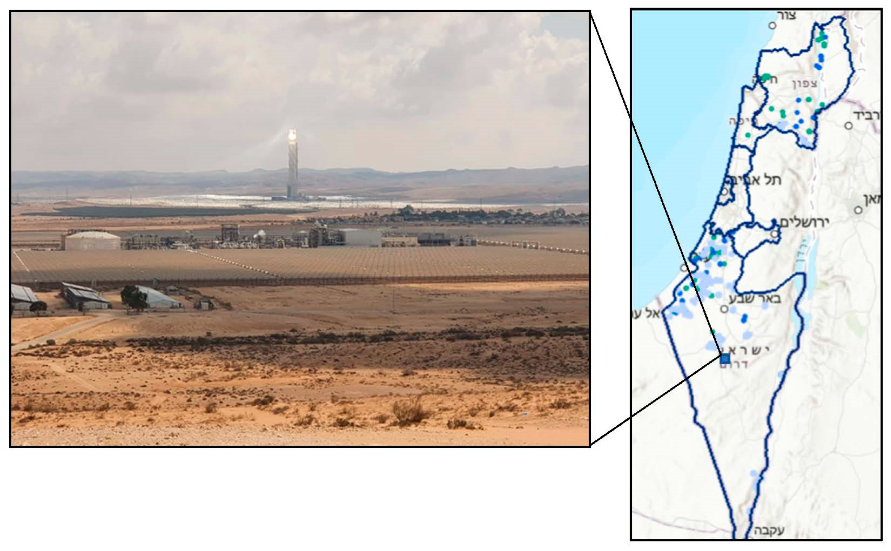
Figure 1.
Plot B solar-thermal “sun tower” plant. A view on Kibbutz Ashalim, the glittering tower, the power station, agricultural fields, and the desert landscape (Photo by: Golan Woolf 2021, with permission). On the right, Figure 2 points to the location of the plant on a map of the country and marks all approved plans for solar plants (mostly PV). Titles in Hebrew mark major cities (from north to south: Haifa Tel-Aviv, Jerusalem, Beer-Sheva and the inner borders mark districts (Northern, Central, Southern, etc.). Source: Planning Authority, 2022.

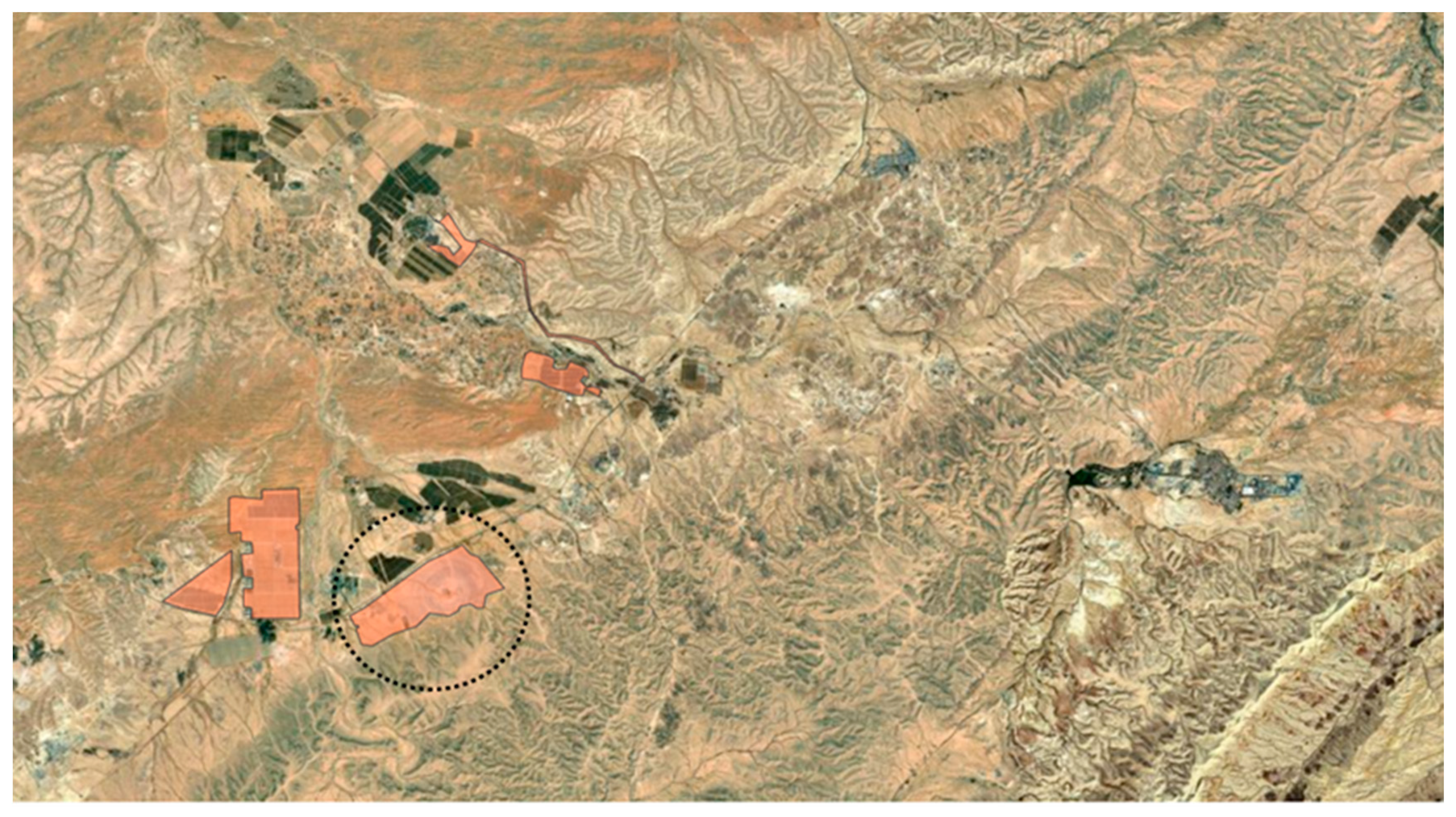
Figure 2.
Topographic layer zoom-in on the Ashalim tower powerplant, 2018 (Plot B circled. Other orange polygons are additional solar energy fields) (Source: Planning Authority).
Figure 2.
Topographic layer zoom-in on the Ashalim tower powerplant, 2018 (Plot B circled. Other orange polygons are additional solar energy fields) (Source: Planning Authority).

Table 1.
Basic socio-spatial and RES data for Israel (sources: Israel Bureau of Statistics and Electricity Authority Report for 2020).
Table 1.
Basic socio-spatial and RES data for Israel (sources: Israel Bureau of Statistics and Electricity Authority Report for 2020).
| Population (Million) | Size (km2) | Average Population Density (Inhabitants/km2) | Solar Production all Types (2020) | Solar Targets (2025) | Total RES Targets (2025) | Targets RES Share/Electricity Generation |
|---|---|---|---|---|---|---|
| 9.449 | 21,937 | 430.7 | 2.5 GW | 8.6 GW | 9.8 GW | 20% (2025) 30% (2030) |
Publisher’s Note: MDPI stays neutral with regard to jurisdictional claims in published maps and institutional affiliations. |
© 2022 by the authors. Licensee MDPI, Basel, Switzerland. This article is an open access article distributed under the terms and conditions of the Creative Commons Attribution (CC BY) license (https://creativecommons.org/licenses/by/4.0/).
Share and Cite
MDPI and ACS Style
Romov, E.; Teschner, N. A Place under the Sun: Planning, Landscape and Participation in a Case of a Solar Powerplant in the Israeli Desert. Sustainability 2022, 14, 7666. https://0-doi-org.brum.beds.ac.uk/10.3390/su14137666
AMA Style
Romov E, Teschner N. A Place under the Sun: Planning, Landscape and Participation in a Case of a Solar Powerplant in the Israeli Desert. Sustainability. 2022; 14(13):7666. https://0-doi-org.brum.beds.ac.uk/10.3390/su14137666
Chicago/Turabian StyleRomov, Ela, and Na’ama Teschner. 2022. "A Place under the Sun: Planning, Landscape and Participation in a Case of a Solar Powerplant in the Israeli Desert" Sustainability 14, no. 13: 7666. https://0-doi-org.brum.beds.ac.uk/10.3390/su14137666
Note that from the first issue of 2016, this journal uses article numbers instead of page numbers. See further details here.