Article

Impact of Dense Networks of Reservoirs on Streamflows at Dryland Catchments

by
Udinart Prata Rabelo
1,*,
Alexandre C. Costa
2,
Jörg Dietrich
3,
Elahe Fallah-Mehdipour
3,
Pieter Van Oel
4 and
Iran Eduardo Lima Neto
1
1
Department of Hydraulic and Environmental Engineering, Federal University of Ceará, Campus do Pici, Fortaleza 60400-900, CE, Brazil
2
Institute of Engineering and Sustainable Development, University of International Integration of the Afro-Brazilian Lusophony, Campus das Auroras, Redenção 62790-970, CE, Brazil
3
Institute of Hydrology and Water Resources Management, Leibniz Universität Hannover, Appelstr. 9A, 30419 Hannover, Germany
4
Water Resources Management Group, Wageningen University & Research, 6708 PB Wageningen, The Netherlands
*
Author to whom correspondence should be addressed.
Sustainability 2022, 14(21), 14117; https://0-doi-org.brum.beds.ac.uk/10.3390/su142114117
Submission received: 24 September 2022 / Revised: 23 October 2022 / Accepted: 27 October 2022 / Published: 29 October 2022

Abstract

:
Small reservoirs play an important role in providing water to rural communities. Increased construction of small reservoirs to mitigate the effects of droughts leads to a High-density Reservoirs Network (HdRN) of small reservoirs, which can potentially modify the streamflows both in dry and wet periods. However, there is a lack of understanding of the interannual behavior of flow retention and the impact of future increases in the number of small reservoirs, mainly for HdRN in dryland catchments. This research aims to determine the possible impact of the increase in the number of small reservoirs on dry hydrological networks, evaluating the annual flows generated at the outlet of a dryland watershed for scenarios with different densities of small reservoirs (number of reservoirs per area). The study area was the Conceição river catchment (3347 km2) in the semiarid of Brazil. The hydrological model of the study area was developed in SWAT. The model obtained appropriate results for daily streamflows, with values of 0.63, 0.81, and 0.53% for NSE, KGE, and PBIAS, respectively. The current density of small reservoirs in the region was estimated at 0.068 reservoirs per square kilometer (res/km2). Eight expansion scenarios were defined for densities between 0.1 res/km2 and 3.0 res/km2. The results showed that the influence of the HdRN on runoff reduction mostly occurs for a probability of exceedance between 1% and 10% of month flows and is very small for months with very high peaks of flow. The reduction in the outlet flow due to the increase in the number of small reservoirs was stronger during dry years (up to 30%) than during wet years (up to 8%), and it tended to increase in years with a consecutive lack of rain (from about 7% in the first year to about 20% in the last year and in the worst scenario), which may intensify the period of extended droughts. This research provides insights about the impact of the increase in the number of small reservoirs on the interannual variability of flow retention, and the understanding of the influence of small reservoirs on runoff reduction may help water resources agencies better prepare for hydrologic extremes (droughts and floods).

1. Introduction

Reservoirs are a water infrastructure used worldwide for compensating natural flow variability [1]. In dry regions, the water stored in reservoirs has a fundamental importance to supply the population’s water demand during the dry seasons and droughts, as well as the use of water for industrial processes and food production by irrigation [2]. The increase in the population and the consequent growth in water demand, combined with climate and land use changes, have put pressure on water resources and increased the risk of severe hydrological droughts over the years in these dry regions [3]. The combination of strategic reservoirs with many small reservoirs in dryland catchments generates a High-density Reservoirs Network (HdRN) that should improve water security, but it can modify streamflows during dry and wet periods.
The construction of public (strategic) reservoirs promoted by state water agencies was an important factor for population water security during the last century [4]. Despite this, the hydraulic network for water distribution in many regions has several limitations, including not reaching the population further away from urban centers, which is mainly in rural communities. Thus, the construction of small and medium-sized reservoirs has intensified in recent decades. These small reservoirs (below 1 million m3) are often built by the population itself or by farmers as they are essential for the availability of water in these rural communities. In addition to the importance of reducing inequality in the water distribution for water-scarcity regions, these small reservoirs have low costs [2,5].
On the other hand, most of the time, the building of small reservoirs occurs without technical supervision, lacking hydrological studies and disregarding the potential impacts on the availability of water for downstream regions [1,6]. Usually, small reservoirs represent risks to the population downstream in the rainy season, since many of these reservoirs do not have well-sized structures for flood control, with the risk of a dam break during periods of more intense floods. Small reservoirs are often constructed in the cascade scheme along the rivers, so the rupture of an upstream reservoir can cause the downstream reservoir to fail, with catastrophic consequences for the population downstream [7,8].
One reason it is hard to estimate the cumulative impact of the HdRN on the hydrological processes of a region is a lack of data about small reservoirs, mainly information on storage capacity and surface area. Their mapping has grown a lot in recent years with the advancement of remote sensing techniques, which enable the acquisition of surface areas during rainy periods from satellite images combined with digital elevation models, and consequently, the estimation of storage capacities [3,5,9,10]. The spatial density of small reservoirs is quite different around the world. For example, densities range from 0.05 small reservoirs per km2 in Nigeria to 0.4 small reservoirs per km2 in Myanmar [5]. However, some specific dryland watersheds reach even higher values: India has 4.2 small reservoirs per km2 [11], while Brazil has 7 small reservoirs per km2 [3], and Australia has 10 small reservoirs per km2 [12].
The understanding of small reservoirs’ dynamics is extremely important for the management of water resources in dryland regions because their impacts on the hydrological network depend on their dimensions, uses, and locations. Recent studies have been carried out to assess the cumulative impact of small reservoirs, such as the increase in evaporation losses [13,14] and the decrease in runoff generated in the catchment [1,4,15,16,17,18]. In addition, other studies have investigated the effect of small reservoirs on sediment retention dynamics [19,20,21], the reduction of energy demand for water pumping [22], and the evolution and intensification of drought events [3,6,23].
Another important effect of small reservoirs is on the water quality of the hydrological network, which is a risk associated with the misuse of small reservoirs. Many studies have been documented on the effects of nutrient accumulation in man-made reservoirs. For drylands, water supply reservoirs may be recurrently eutrophic or hypereutrophic, mainly due to phosphorus (P) and nitrogen (N) loads, which is a great concern for integrated water resources management. Sediment retention increases the amount of nutrients in small reservoirs, mainly P and N [24,25]. Extended droughts may intensify the eutrophication of these reservoirs. River streamflows carrying fertilizers and sewage provided by agricultural and urban practices may increase the number of pollutants in small reservoirs, such as pesticides, fecal coliforms, and even heavy metals. Furthermore, as the small reservoirs may be used for the population supply, the increase in diseases associated with poor water quality can bring health risks to the population, such as diarrhea, schistosomiasis, and onchocerciasis [26,27,28,29,30].
A system of small reservoirs can influence hydrological processes at catchment scale [1,18]. However, most studies use highly simplified models to represent small reservoirs in hydrological networks. The storage capacities of small reservoirs, their horizontal connectivity, and their interaction with large strategic reservoirs are not represented in detail, which may lead to the misinterpretation of the role of small reservoirs in simulating interannual variability of runoff. There is a gap in understanding regarding the interannual variability of runoff retention, particularly during hydrologic extremes (floods and droughts), which complicates modeling the effects of future increases in the number of small reservoirs in drylands.
The eco-hydrological model SWAT (Soil and Water Assessment Tool) has been widely used for hydrological simulation in watersheds, and it has obtained good results for application in dryland regions [31,32,33,34,35,36]. Despite this, even complex models such as SWAT need adjustments to modeling small reservoirs, since the large number of them usually have limitations to be implemented in the models.
A recent study using remote sensing in the State of Ceará, which was carried out by the Research Institute of Meteorology and Water Resources of Ceará (FUNCEME), identified more than 105,000 dams with widths starting from 20 m. The territorial area of the State of Ceará is approximately 150,000 km2, with almost 87% of this area inside the Brazilian semiarid. This distribution of small reservoirs is not uniform, so some regions have very high densities of small reservoirs, especially in locations that are close to the largest strategic reservoirs in the State [37]. For these small reservoirs, water agencies in Ceará do not have information on systematic volume monitoring; rather, they only have information on strategic reservoirs. It is estimated that a recent drought in Ceará (2012–2017) caused losses of more than USD 6,000,000,000 [3]. These extended droughts encourage the construction of even more medium and small reservoirs to meet the water demand of small rural communities. The first studies carried out by Ribeiro Neto et al. [3] identified that small reservoirs can induce and modify drought events, extending hydrological droughts by an average of 30%. However, the influence of small reservoirs in the emergence, intensification, and propagation of droughts in drylands at watershed level still has few studies based on the modeling of these HdRN. Also, considering the limitations in the data on small reservoirs, the impact of small reservoirs in the annual streamflows at dryland catchments can still be better understood, such as the interannual influence that these HdRN have on the reduction of flows during wet and dry years.
The present study aims to determine the impact of the increase in the number of small reservoirs on dry hydrological networks, evaluating the annual flows generated at the outlet of a dryland watershed for scenarios with different densities of small reservoirs (number of reservoirs per area). To achieve this objective, a detailed representation of a watershed, including large and small reservoirs, was modeled in SWAT. The study area was in the Brazilian semiarid region. The methodology generated a scenario approach for several hypotheses of growth in the density of small reservoirs in the catchment. The present study improves the understanding of the hydrology of dense reservoir networks, and it uses a modeling approach that can be applied to water resources management in drylands.

2. Materials and Methods
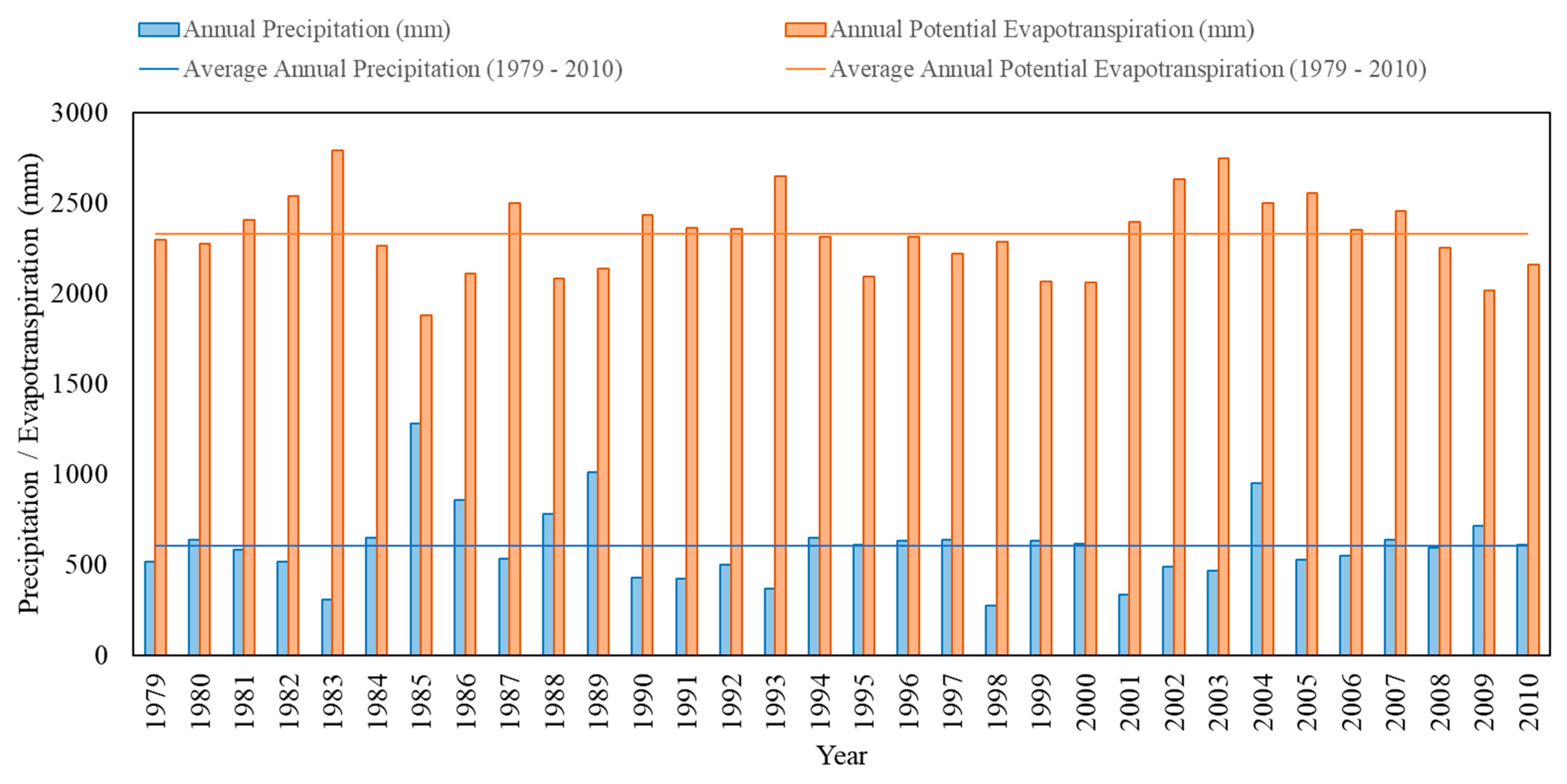
2.1. Study Area

The study was carried out in the Conceição catchment (3347 km2), which is in the state of Ceará, located in the northeast of Brazil (Figure 1). The Conceição River is a tributary of the Upper Jaguaribe River basin (UJB), which is a sub-catchment of the Jaguaribe River basin (75,000 km2). The Jaguaribe River is the most important river in Ceará, and basin reservoirs were constructed all over the river basin to store water for agricultural, industrial, and domestic use.
The climate in the region is classified as semiarid, or “Bsh,” according to the Köppen classification, characterized by a clear distinction between rainy and dry seasons. The rainy season occurs between the months of January and May, concentrating approximately 80% of the annual rainfall. The period from June to December is characterized by a decrease in river streamflow (low flows) and a high evapotranspiration rate. The annual precipitation in the region has an average around 600 mm, while the annual potential evapotranspiration has an average around 2300 mm, which is almost four times greater than the annual precipitation. The annual precipitation and evapotranspiration provided by an interpolated series during the simulation period (1979–2010) are presented in Figure 2.
The soil of the region is characterized by being shallow, with low hydraulic conductivity and porosity. Geologically, 80% of the region is composed of a complex of crystalline rocks, with a low occurrence of aquifers. Consequently, the combination of soil-related factors, high spatial and temporal variability in rainfall, and high annual evapotranspiration rates make the rivers of the region intermittent. Thus, the occurrence of droughts in the region is quite recurrent, even in consecutive years, or so-called extended droughts.
The streamflows at the Conceição River catchment are monitored daily at the Malhada Station. Figure 1 presents the Malhada Gauging Station and all reservoirs identified by FUNCEME [37] for the catchment. There are four strategic reservoirs monitored by the Water Agency of the State of Ceará (COGERH), including Poço da Pedra, Benguê, Do Coronel, and Mamoeiro. The privately built reservoirs with different sizes and shapes (main private reservoirs and small reservoirs) are usually referred to as small reservoirs. Despite not being one of the regions in Ceará with the highest density of small reservoirs, this availability of flow data is critical to assess the impacts of human processes on the hydrological network, such as the increase in the construction of small reservoirs to supply rural communities. In addition, the study area was also chosen based on the frequent droughts that occur, thus representing a very dry region of the Brazilian semiarid.

2.2. Model Parameterization

The SWAT model was used to model hydrological processes and reservoirs and simulate streamflows in the outlet of the catchment. The delineation of the watershed and its river network (Figure 1) were carried out based on a digital elevation model (DEM) with 90 m resolution. The climate data were made available by FUNCEME. All the analyzed scenarios of small reservoirs were based on the SWAT model, which was calibrated and validated for the Conceição River catchment available from Rabelo et al. [1]. To clarify the modeling processes carried out in SWAT, the parameterization of large and small reservoirs and the calibration of the model are briefly presented in the following sections.

2.2.1. Reservoir System

The modeling of reservoirs was carried out as follows: the analysis of aerial images in the Conceição River catchment identified 230 reservoirs after the rainy seasons in 2004, 2008, and 2009; the volume and the area of these reservoirs were estimated using the Molle’s equation [38] adapted by Pereira [39]; water impoundments caused by dam constructions built across the main river reach and with an estimated storage capacity larger than 0.01 hm3 were modeled in the “reservoir” structure of the SWAT model (strategic reservoirs and main private reservoirs); and the remaining reservoirs were modeled in the “pond” structure of the SWAT model (small reservoirs). Due to the large number of small reservoirs and the limitation of SWAT2012 in allowing only one “pond” per sub-basin, they were aggregated into a single “pond” for each sub-basin via the cascade or parallel arrangement. A more detailed description of the methodology for the aggregation of small reservoirs into ponds via cascade and parallel arrangement is available in the Section S1 of the Supplementary Materials. The results of the reservoir modeling in the contribution area can be summarized as follows: 230 reservoirs distributed in a total area of 3347 km2, with four strategic reservoirs (capacity = 73.33 hm3), 14 private reservoirs (capacity = 5.28 hm3), and 212 small reservoirs (capacity = 13.70 hm3). The density of reservoirs in the region is estimated at 0.068 reservoirs per km2 (about one reservoir per 14.81 km2). However, Mamoeiro reservoir was disregarded in the analysis due to this strategic reservoir becoming operational only in 2012, which was after the last year of the simulation (1979–2010). This model was considered in the study as a reference model.

2.2.2. Calibrated Model

The parameterization of strategic reservoirs used information obtained from COGERH for the surface area when the reservoir filled to emergency spillway (RES_ESA), the storage volume when the principal reservoir filled to emergency spillway (RES_EVOL), the surface area when the reservoir filled to emergency spillway (RES_PSA), the storage volume when the reservoir filled to principal spillway (RES_PVOL), the initial reservoir storage volume (RES_VOL), the target storage volume (RES_TARG), the month in which the reservoir became operational (MORES), the year in which the reservoir became operational (IYRES), the hydraulic conductivity of the reservoir bottom (RES_K), and the lake evaporation coefficient (EVRSV). The number of days to reach the target storage from the current reservoir storage (NDTARGR) was defined for each reservoir using the Poleni equation [40]. The withdrawal of water from the strategic reservoirs was considered constant during all months, based on a simplified average approach measured by the water agencies.
The parameterization of the main private reservoirs and of the ponds was done by defining the same model parameters as the strategic reservoirs. However, no data were available for them from COGERH. The flooded areas were estimated via aerial images and the storage volumes were calculated using the adapted Molle’s equation. The application Google Timelapse was used to determine the parameters MORES and IYRES of the main private reservoirs, while SWAT assumed that all ponds existed during the simulation period. The other parameters were defined following the same characteristics of the strategic reservoirs. Detailed information about main private reservoirs and ponds can be found in Rabelo et al. [1]. Table S1 presented in Supplementary Materials summarizes the parameterization of strategic reservoirs and main private reservoirs with a description of all parameters, while Table S2 presented in Supplementary Materials summarizes the parameterization of small reservoirs.
The calibration of the reference model was based on the available data, literature, and experience of the modelers. The following methods were used by applying the curve number method, plant evaporation method, and Muskingum method for the calculation of infiltration, evapotranspiration, and channel routing, respectively. The parameters to describe the rainfall–runoff relationship were calibrated with an iterative trial and error procedure, by keeping parameter values in a physically meaningful range. Initial values for the model parameters were derived from field data as much as possible. When field data were not available, dryland-based literature values were chosen for them. Tables S3–S5 presented in Supplementary Materials show parameters set for the entire catchment, parameters set for specific sub-basins of the catchment, and parameters set for specific soil zones, respectively. More detailed information about model parameterization and calibration can be found in Rabelo et al. [1].
The main aim of this study is not to produce an in-depth discussion of the calibration criteria of the River Conceição catchment model in SWAT. Some information is still important regarding the calibration and the validation of the model. The model parameters were calibrated using an iterative trial and error process, considering each sub-catchment of the three strategic reservoirs separately. The first two years (1979–1980) were considered warm-up years in the simulation. A two-fold cross-validation was performed using both halves of the series (1981–1995 and 1996–2010). First, the time series 1981–1995 was used for calibration, while the second time series was used for validation. Subsequently, the process was inverted to consider the time series 1996–2010 as the calibration series and the time series 1981–1995 as the validation series. After the two-fold cross-validation process, the parameters of the models were defined to maximize the Nash–Sutcliffe–Efficiency (NSE) and Kling–Gupta–Efficiency (KGE) statistical parameters and to minimize the percent bias (PBIAS) of the simulated streamflows compared to the daily observed streamflow at the basin outlet (Malhada Station). The reference model obtained good results for the daily streamflows, with values of 0.63, 0.81, and 0.53% for NSE, KGE, and PBIAS, respectively. A detailed description of the reference model and its results can be found in Rabelo et al. [1].

2.3. Scenarios Approach for an Increase in the Number of Small Reservoirs

To assess the impact of the increase in the number of small reservoirs in the watershed, eight scenarios with different numbers of small reservoirs were chosen, based on the technical report “Mapping of the dams of small reservoirs located in the State of Ceará” by FUNCEME [37], which identified reservoir densities with values distributed between zero and two reservoirs per km2 in Ceará territory. Thus, the scenarios of small reservoirs per km2 in this study were chosen based on the classes defined by the assessment of FUNCEME, with the inclusion of one value above this range: 0.10 res/km2, 0.25 res/km2, 0.50 res/km2, 0.75 res/km2, 1.00 res/km2, 1.50 res/km2, 2.00 res/km2, and 3.00 res/km2.
The addition of small reservoirs in the model has the following methodology: for each value of reservoir density, the number of reservoirs distributed in the total area of 3347 km2 of the catchment was calculated; and the number of strategic reservoirs was kept constant in the modeling, so the number of reservoirs exceeding the reference model was due only to the addition of private reservoirs and small reservoirs. The calculation of the addition of these two types of reservoirs in the scenarios was done keeping the same proportion of main private reservoirs and small reservoirs in the reference model. This number of additional reservoirs was converted into volume using the average volume of private reservoirs and the average volume of small reservoirs in the watershed, and then distributed equally in the model. This methodology considered the hypothesis that the construction of new reservoirs in this region will be uniformly distributed along the catchment. In this way, the process of the increase in the number of small reservoirs was performed by the addition of these volumes in each pond and in each main private reservoir of the model, increasing the parameters RES_EVOL and RES_PVOL in SWAT. These increases in the SWAT parameters of small reservoirs were carried out for all scenarios of densities of small reservoirs as summarized in Table 1. It is important to note that none of the other SWAT parameters of the small reservoirs were changed, remaining equal to the values of the reference model.
The different scenarios of small reservoirs modeled in SWAT were simulated between 1979 and 2010. The results obtained from the simulations were the Flow Duration Curves (FDCs) for monthly flows and the annual streamflow obtained at the basin outlet (Malhada Station) for each of the scenarios. The annual streamflows were compared between the data observed by COGERH, the previously calibrated model (reference model), and the different scenarios of the increase in small reservoirs. For this comparison, we used the annual anomaly for precipitation (1) and for discharge (2) and the percentage of reduction in the annual discharge (3) in the catchment, between the years 1981 and 2010 (the first two years were considered as model warm-up) for each scenario.
Annual   Anomaly   ( precipitation ) = P y   P a P a   ( % ) ,
Annual   Anomaly   ( discharge ) = Q y   Q r , a Q r , a   ( % ) ,
Percentage   Reduction   of   Annual   Discharge   = Q s , y   Q r , y Q r , y   ( % ) ,
where Py represents the total precipitation in year “y”; Pa represents the average annual precipitation from 1981 to 2010; Qy represents the annual accumulated discharge in year “y”; Qr,a represents the average annual discharge from 1981 to 2010 for the reference model; Qs,y represents the annual discharge for different scenarios in year “y”; and Qr,y represents the annual discharge for the reference model in year “y”.
Since other model parameters were not changed, new calibration and validation processes of the simulations were not necessary.
Figure 3 illustrates the main flowchart of this study with a summary of all the steps applied.

3. Results

3.1. Simulated Impact of Small Reservoirs on Streamflow

The first results are the duration curves on a monthly scale for the simulated flows at the outlet (Malhada station). Two FDC were initially defined as references to compare the results: the duration curve that was provided by the values that were measured using COGERH at Malhada station and the duration curve that was provided by the reference model (reservoir density = 0.068 res/km2). For a better graphical representation, only the two extreme results of the simulations are presented in the duration curves (Figure 4): the scenario in which there is no reservoir and the scenario with the largest number of reservoirs in the simulation (3 res/km2). All other scenarios had intermediate values between these two. As the study area is in a semiarid region with ephemeral streamflow in the river, most of the time, river flow becomes next to zero. To analyze the impact of the small reservoirs in the period that the flows are effective, the flow duration curves (Figure 4) are also presented showing only the first 20% of the time when the flow is exceeded. For 80% exceedance probability, the remaining runoff in the catchment is almost zero; consequently, there are no significant differences between the simulated scenarios.
In Figure 4, we can observe the impact of the small reservoirs in the 20% of the time when the flows have relevant values. The simulation with the absence of reservoirs presents the highest values of the monthly flow for the same percentage of time in which this flow is exceeded. For example, the monthly flow around 580 m3/s is exceeded 5% of the time for the simulation without reservoirs, while for the other three scenarios, this monthly flow is about 420 to 460 m3/s. For a 10% exceedance time, the monthly flow is around 150 m3/s at the no reservoir’s scenario, around 100 m3/s at the observed values by COGERH, around 130 m3/s at the calibrated model, and around 110 m3/s at the 3 res/km2 scenario. Differences can reach over 60% in some cases, such as for an exceedance probability of around 8%. The FDC for a density of small reservoirs equal to 3 res/km2 is significantly below the FDC of 0 res/km2 between 1% and 10% of the time in which the monthly flows are exceeded. For values of exceedance probability next to 0%, the differences in monthly streamflow tend to decrease (a maximum value around 7%). These values of streamflow represent months with very high peaks of flow. In these situations, all reservoirs in the catchment (strategic and small reservoirs) tend to have spillway overflows, and the impact of reservoirs on flow reduction diminishes during these periods [1,3].
The FDCs in Figure 4 show that the impact of small reservoirs on the decrease of water during the rainy months is more intense with the increase in the number of small reservoirs. Although most studies in the literature focus on the decreased annual stream discharge, for peak flows, the impact of these small reservoirs is estimated to be up to 45% of the reduction [18,41]. For flows next to zero, a more detailed analysis is necessary, and there is a limitation in the SWAT model for low flows in dryland catchments due to transmission losses [1].
The mapping of dams available by FUNCEME identifies that the highest densities of small reservoirs occur in regions close to the largest strategic reservoirs. Thus, there is a tendency to build small reservoirs in these regions, mostly to take advantage of the regularization of water that strategic reservoirs provide to rivers. Despite this, as the study area does not have the highest densities of small reservoirs in the state, the assumption of adding small reservoirs uniformly along the watershed is a simplification in the model to evaluate the impact of small reservoirs in the simulations.

3.2. Annual Streamflow Anomaly

As a starting point for the study of annual flows for the study area, three anomaly graphs were obtained. The first was provided by the annual rainfall anomaly (precipitation anomaly); the second was provided by the annual anomaly of the flows measured by COGERH (measured discharge anomaly); and the was third provided by the annual anomaly of the flows simulated by the reference model (simulated discharge anomaly). The objective of the anomaly graphs is to identify the years with greater deviations in rainfall and runoff and to observe the behavior of the precipitation and the measured and simulated streamflows at the Malhada gauging station during wet and dry years. Figure 5 shows the three annual anomaly graphs from 1981 to 2010.
The analysis of the anomaly graphs identifies high positive deviations in precipitation and measured discharge in 1985, 1986, 1989, and 2004 (wet years), high negative deviations in precipitation in 1983, 1990–1993, 1998, and 2001–2003 (dry years), and high negative deviations in measured discharge in 1982–1983, 1990–1994, 1996, 1998–2003, 2005–2008, and 2010. The other years had values close to the average. The pattern of positive deviations in precipitation implying positive deviations in streamflows is observed for other regions around the world for drought studies [42,43]. However, this cause-and-effect relationship is not so clear for low precipitation and low flow years. In dryland catchments highly modified by human activities, there is a strong nonlinear pattern between rainfall and runoff [44]. This nonlinearity can be observed not only during dry years, but also during wet years when deviations in discharge are much greater than deviations in precipitation.
In order to understand the effects of the increase in the number of reservoirs on the streamflows, the total annual flows were obtained at the Malhada station each year and in each of the following scenarios: reference model (0.068 res/km2), 0.10 res/km2, 0.25 res/km2, 0.50 res/km2, 0.75 res/km2, 1.00 res/km2, 1.50 res/km2, 2.00 res/km2, and 3.00 res/km2. In each year from 1981 to 2010, and in each simulated scenario, the differences between the total annual flows were calculated considering the flows in the reference model as base values. In this way, Tables S6 and S7 presented in Supplementary Materials show, respectively, the values of annual streamflows at the Malhada gauging station and the percentage difference in streamflows compared to the flow obtained for the reference model in each scenario of increase in reservoir density and in each year. This percentage difference represents the annual reduction in flow due to the increase in small reservoirs in each scenario.
A combination between the anomaly graphs and the annual reduction in flow table (Table S7) was developed to analyze the influence of the increase in the number of small reservoirs in the streamflows for all years of the series, mainly wet and dry years. Figure 5 shows the three anomaly graphs, with an indication of their percentage on the left axis, the annual reduction values for each simulated scenario, and an indication of their percentage on the right axis.
The annual streamflow reduction at the Malhada gauging station for the scenario approach had values from 1% (0.1 res/km2) to 14% (3.0 res/km2), on average. The analysis of Figure 5 shows that the greatest ranges in flow reduction correspond to the years 1983 (1.6% to 21.5%), 1998 (2.0% to 30.3%), 1999 (0.8% to 23.5%), and 2005 (2.5% to 29.8%). Compared to the anomaly graphs, we notice that these years correspond to dry years, with the highest negative bias in precipitation mainly in the years of 1983 and 1998, and negative bias in the runoff mainly in the years of 1983, 1998, and 2005. Habets et al. [18] point out that during dry years, the reduction in annual discharge tends to be twice as high as in median years, and these results can be observed even without changes in the small reservoir network, just due to the seasonality of the climate. For dry years, the reported decreases in the annual discharges have a high range, from values close to 0% to values up to 50% [1,12,45,46]. The results for dry years in our simulations suggest the an increase in the number of small reservoirs leads to an intensification of the hydrological drought during the dry years, since these years have a higher percentage of flow reduction with the increase in the number of small reservoirs.
On the other hand, the smallest ranges in flow reduction occur in the years 1986 (0.3% to 5.5%), 1989 (0.2% to 6.7%), and 2004 (0.2% to 7.6%). The years 1986, 1989, and 2004 correspond to wet years, with positive bias in rainfall and flows. The last two years have a large positive bias in the flows measured at the Malhada Station, while the first (1986) is the year following the year with the highest positive anomaly for the flows (1985). This result suggests that in rainy years, the increase in the number of small reservoirs has less impact on the reduction of streamflow. As the small reservoirs have small capacities, their filling occurs quickly during the wettest years, making the network hydraulically connected, with excess overflows going more easily to downstream regions and reducing the volume retained in each reservoir. Other studies found that when storage capacities of all reservoirs are close to the maximum, the impact of the small reservoirs are limited [3].
Another two years with low ranges in streamflow reduction, if individually observed, are 1990 and 2001. The year 1990 represents the beginning of an extended meteorological drought between 1990–1993, while the year 2001 represents the beginning of another extended meteorological drought between 2001–2003. In these cases, the reduction of flows intensified with the extension of the meteorological drought. For example, in 1990, the annual flow reduction due to the increase in the small reservoirs ranges from 0.3% to 7.1%, while in 1993, the annual flow reduction ranges from 3.5% to 15.9%. In 2001, the range is from 0.6% to 5.8%, while in 2003 the range is from 1.0% to 18.6%. These results suggest that the increase in the number of small reservoirs can intensify the period of extended droughts because the few flows generated in the catchment are retained by the small reservoirs. Ribeiro Neto et al. [3] suggest that dense networks of small reservoirs can induce and intensify drought events, mainly causing the onset of a hydrological drought earlier and extending the duration of this drought.
If in the year following an extended meteorological drought the precipitation occurs around the mean, the reduction in streamflows tends to remain high, since this average rainy season would not be able to fill all the reservoirs. We can observe this result in 1994, with a range in flow reduction between 1% and 16% for the scenarios, which are values close to the year 1993 (the end of the meteorological drought). However, if in the year following an extended meteorological drought the precipitation occurs well above the average, the tendency is a small reduction in the annual runoff, since the reservoirs in the hydrological network would quickly become full. This result can be observed in 2004, with a range in flow reduction between 0.2% and 7.6%, which is almost half the range observed in 2003 (the end of the meteorological drought).
The analysis of Figure 5 also shows that the increase in the number of small reservoirs has a strong nonlinearity effect on the increase in flow reduction, even in dry or wet years. For dry years (1983, 1998, and 2003), different ranges are observed (up to 21.5% for 1983 and up to 30% for 1998 and 2003), although there are nearby anomalies for precipitation and streamflow. For wet years (1985, 1989, and 2004), the differences in the ranges are up to 9.4% in 1985, up to 6.7% in 1989, and up to 7.6% in 2004. The years with rainfall around the average also have average reduction values. In this situation, the reduction values for the scenario with 0.1 reservoir per km2 range from 0.1% to 1.0%, while for the scenario with three reservoirs per km2, the values range from 8.2% to 17.5%. Figure 5 shows that there is no linearity between the increase in the small reservoirs and the streamflow reduction, as years with nearby anomalies for precipitation and streamflow have different ranges and peak values in annual flow reduction.

4. Discussion

The amount of water retained in small reservoirs is important information for water resources management in regions with dense networks of reservoirs. These HdRN can be found in dry areas in different countries, such as Brazil, the USA, West Africa, and Australia. Reservoir management is critical for water availability and sustainability in dry regions. The integration of the cumulative effect of small reservoirs must be considered in the hydrological network, either from models or from average estimates of accumulated volume and nutrient loads, mainly in dry years. The estimation of the total volume of water accumulated in small reservoirs during dry or wet years is hampered by the lack of monitoring in them, which is hard to obtain due to the high number of small reservoirs. This is one of the main limitations for considering small reservoirs in water management [18,23]. Furthermore, with the prognosis of population growth, economic development, urbanization, and climate change in the future, the increase in the number of small reservoirs can be a challenge for water agencies [1,30,47].
The impact of small reservoirs in streamflows is currently small compared to strategic reservoirs. For the Conceição River catchment, Rabelo et al. [1] found, on average, a 2% annual flow retention with the density of reservoirs equaling 0.068 res/km2. However, the increase in the number of small reservoirs may increase the effects in the streamflows of the hydrological network. In this sense, scenarios with higher densities of small reservoirs can lead to cumulative impacts, increasing the flow retention to values close to those found for large reservoirs impacts [18,47]. This study obtained, on average, streamflow reductions from 1% to 14% in semiarid Brazil for densities of reservoirs from 0.1 res/km2 to 3.0 res/km2, while studies in semiarid West Africa obtained flow reductions of 14% in mean annual streamflow for scenarios with 0.08 res/km2 [30].
By an analysis of around 30 references, Habets et al. [18] showed that similar densities of small reservoirs can lead to different flow retentions (from 5.4% to 21.4%), as we see for semiarid Brazil and semiarid West Africa. The definition of a single indicator, as the density of small reservoirs in the area, to provide a first guess for the flow retention of small reservoirs has limitations due to the hydro-climatic conditions. The distribution of the reservoir network in dryland catchments and the hydrological processes in these regions, such as transmission losses and increased evaporation by small reservoirs, should be evaluated to better understand the streamflow reduction caused by small reservoirs [1,30].
The impact of the increase in the number of small reservoirs on streamflow reduction occurs strongly during dry years with low flows. The decrease in low flows also has a large range that is between 0.3 and 60% in Australia, Brazil, New Zealand, South Africa, and the USA [1,18,30]. In addition, this research found values of up to 30% of streamflow retention for scenarios with densities of reservoirs until 3.0 res/km2, while during extended drought years, the values of retention ranged from 0.3% to 18.6%. These results lead to the intensification of droughts by the increase in the number of small reservoirs.
When a meteorological drought starts, an increase in well digging for water supply is common. In a region with low availability of underground water, the construction of small reservoirs becomes a possibility for the local population to cope with droughts. The spatial distribution of reservoirs has a great impact on the occurrence of the hydrological drought. As streamflow drought responds more quickly than reservoir drought to a meteorological drought, the presence of water stored in small reservoirs can cause a delay between the beginning of the meteorological drought and the beginning of the hydrological drought, mainly in upstream regions. These small reservoirs dry up quickly in the dry season; consequently, downstream reservoirs suffer the effects of droughts more quickly [23,48,49,50,51]. In dense networks of reservoirs, this problem may be aggravated. As the presence of a dense network of reservoirs can lead to a 30% increase in the duration of hydrological droughts, the greater the number of small reservoirs, the greater the impact on water availability in the region [3]. Despite those results, it is still hard to individually evaluate the impact of small reservoirs on the transition from meteorological drought to hydrological drought due to the complexity of the hydrological processes in the catchment. Many authors observed a clear nonlinear relationship of hydrological drought and meteorological drought in different regions, with nonlinear functions modeled to propagation threshold from meteorological drought to hydrological drought [52,53,54].
The impact of small reservoirs on streamflow reduction is smaller during rainy years. In these years, as the precipitations are high and the small reservoirs usually fill quickly, the overflow of the spillways quickly occurs in most of the small reservoirs. In this sense, for rainy years, the hydraulic connectivity is achieved, and the potential for water held in small reservoirs decreases, as they are already full [1,3].
The accumulation of water in small reservoirs during rainy years has important social and economic functions for rural communities. Not only in the Conceição River catchment, but also in several other watersheds in regions with a semiarid climate, small reservoirs act as an important structure to increase the population’s water access [1,30].
One of the main benefits is the use of this available water for irrigation and food production, bringing food security to these communities. Both small families and farmers in these regions may also use agricultural activities, fishing, and aquaculture as sources of income. As the water infrastructure to transport water to the population far from urban centers is often expensive, these small reservoirs are invaluable for the livelihoods of rural communities. In addition to the small reservoirs, the population of these regions usually uses wells for supply. The impact of small reservoirs on groundwater recharge is still unknown for dense networks of reservoirs at dryland catchments [55,56].

5. Conclusions

This study analyzed the impact of the increase in the number of small reservoirs in large-scale dryland catchments. We used a SWAT model to simulate the streamflows for the Conceição River catchment (semiarid of Brazil), and we applied a methodology to represent the increase in the number of small reservoirs per square kilometer in the catchment.
The main findings of this study are:
  • The impact of reservoirs on flow reduction is very small for periods of extreme high flows. In this period, the comparison of monthly streamflows between the reference model and the scenarios with and without reservoirs have an approximate maximum difference of 7%.
  • The influence of the dense network of reservoirs on streamflow reduction mostly occurs for a probability of exceedance between 1% and 10% for the Conceição River catchment.
  • There is a strong nonlinear effect for the increase in the number of small reservoirs at the annual streamflow reduction. For different dry years with the same precipitation pattern, the streamflow reduction has different ranges. The ranges of streamflow reduction have no linearity, even for wet and normal years.
  • The impact of the increase in the number of small reservoirs on flow reduction occurs strongly during dry years, with values up to 30% for the higher density of small reservoirs (3 res/km2).
  • The streamflow reduction tends to increase in years with a consecutive lack of rain. In extended droughts, flow reduction ranges from about 7% in the first year to about 20% in the last year of the worst scenario. The increase in the number of small reservoirs may intensify the period of extended droughts.
This research provides insights about the influence of the increase in the number of small reservoirs at dryland catchments. However, as a starting point for the scenario approach, the increase in small reservoirs was evenly distributed across the catchment. For future studies, a more realistic scenario approach should be adopted, with a higher increase of small reservoirs in regions close to large strategic reservoirs and higher population densities.
Small reservoirs on minor tributaries are largely unregulated in most countries, especially in drylands due to water scarcity, yet there is a potential for them to have significant impacts on water availability, with both positive effects and many potential negative impacts. In this sense, the methodology proposed in this study is highly transferable for different catchments worldwide. Moreover, as population growth and climate change trends may intensify the construction of small reservoirs to meet the water demand of rural communities, the future scenarios of growth in the number of small reservoirs and the understanding of their influence on streamflow reduction may help water resources agencies better prepare for future periods of droughts and extended droughts.

Supplementary Materials

The following supporting information can be downloaded at: https://0-www-mdpi-com.brum.beds.ac.uk/article/10.3390/su142114117/s1, Section S1: Aggregation of Small Reservoirs into “Ponds” in SWAT Model; Table S1: Parameterization of reservoirs (water impoundments implemented into the model as reservoirs); Table S2: Parameterization of ponds (water impoundments implemented into the model as ponds); Table S3: Parameterization of calibrated model: Parameters set for the entire catchment; Table S4: Parameterization of calibrated model: Parameters set for specific sub-basins of the catchment; Table S5: Parameterization of calibrated model: Parameters set for specific zones in the catchment; Table S6: Annual streamflow in m3/s at Malhada Station for each increase in the number of small reservoirs per year of simulation.; Table S7: Percentage of annual streamflow reduction at Malhada Station for each increase in the number of small reservoirs per year of simulation.

Author Contributions

Conceptualization, U.P.R., A.C.C. and I.E.L.N.; Methodology, U.P.R. and A.C.C.; Supervision, A.C.C., J.D. and I.E.L.N.; Writing—original draft, U.P.R.; Writing—review & editing, A.C.C., J.D., E.F.-M., P.V.O. and I.E.L.N. All authors have read and agreed to the published version of the manuscript.

Funding

This study was supported by the Foundation for Scientific and Technological Development of the State of Ceará (FUNCAP) (PNE0112–00042.01.00/16) and the Brazilian National Council for Scientific and Technological Development (CNPq) (155814/2018–4; 402514/2021-1).

Institutional Review Board Statement

Not applicable.

Informed Consent Statement

Not applicable.

Data Availability Statement

Not applicable.

Acknowledgments

The authors would like to thank the Foundation for Meteorology and Water Resources of the State of Ceará (FUNCEME) for making available the DEM, the raw information about the landscape properties, the meteorological time series, and the information about small reservoirs. We also thank the Water Agency of the State of Ceará (COGERH) and the Secretary of Water Resources of the Government of Ceará (SRH) for providing reservoir data. Finally, we are grateful for the streamflow time series, which were made available by the Brazilian Water Agency (ANA).

Conflicts of Interest

The authors declare no conflict of interest.

References

  1. Rabelo, U.P.; Dietrich, J.; Costa, A.C.; Simshäuser, M.N.; Scholz, F.E.; Nguyen, V.T.; Lima Neto, I.E. Representing a Dense Network of Ponds and Reservoirs in a Semi-Distributed Dryland Catchment Model. J. Hydrol. 2021, 603, 127103. [Google Scholar] [CrossRef]
  2. Samimi, M.; Mirchi, A.; Moriasi, D.; Ahn, S.; Alian, S.; Taghvaeian, S.; Sheng, Z. Modeling Arid/Semi-Arid Irrigated Agricultural Watersheds with SWAT: Applications, Challenges, and Solution Strategies. J. Hydrol. 2020, 590, 125418. [Google Scholar] [CrossRef]
  3. Ribeiro Neto, G.G.; Melsen, L.A.; Martins, E.S.P.R.; Walker, D.W.; van Oel, P. Drought Cycle Analysis to Evaluate the Influence of a Dense Network of Small Reservoirs on Drought Evolution. Water Resour. Res. 2022, 58, e2021WR030799. [Google Scholar] [CrossRef]
  4. De Araújo, J.C.; Medeiros, P.H.A. Impact of Dense Reservoir Networks on Water Resources in Semiarid Environments. Australas. J. Water Resour. 2013, 17, 87–100. [Google Scholar] [CrossRef]
  5. Mady, B.; Lehmann, P.; Gorelick, S.M.; Or, D. Distribution of Small Seasonal Reservoirs in Semi-Arid Regions and Associated Evaporative Losses. Environ. Res. Commun. 2020, 2, 061002. [Google Scholar] [CrossRef]
  6. Di Baldassarre, G.; Wanders, N.; AghaKouchak, A.; Kuil, L.; Rangecroft, S.; Veldkamp, T.I.E.; Garcia, M.; van Oel, P.; Breinl, K.; Van Loon, A.F. Water Shortages Worsened by Reservoir Effects. Nat. Sustain. 2018, 1, 617–622. [Google Scholar] [CrossRef] [Green Version]
  7. Cao, Z.; Huang, W.; Pender, G.; Liu, X. Even More Destructive: Cascade Dam Break Floods. J. Flood Risk Manag. 2014, 7, 357–373. [Google Scholar] [CrossRef]
  8. Oliveira, L.C.S.; Lima Neto, I.E. Simulation of cascade dam break in a semiarid watershed. Revista DAE 2020, 70, 203–216. [Google Scholar] [CrossRef]
  9. Avisse, N.; Tilmant, A.; François Müller, M.; Zhang, H. Monitoring Small Reservoirs’ Storage with Satellite Remote Sensing in Inaccessible Areas. Hydrol. Earth Syst. Sci. 2017, 21, 6445–6459. [Google Scholar] [CrossRef] [Green Version]
  10. Pereira, B.; Medeiros, P.; Francke, T.; Ramalho, G.; Foerster, S.; De Araújo, J.C. Assessment of the Geometry and Volumes of Small Surface Water Reservoirs by Remote Sensing in a Semi-Arid Region with High Reservoir Density. Hydrol. Sci. J. 2019, 64, 66–79. [Google Scholar] [CrossRef]
  11. Paredes-Beltran, B.; Sordo-Ward, A.; Garrote, L. Dataset of Georeferenced Dams in South America (DDSA). Earth Syst. Sci. Data 2021, 13, 213–229. [Google Scholar] [CrossRef]
  12. Nathan, R.; Jordan, P.; Morden, R. Assessing the Impact of Farm Dams on Streamflows, Part I: Development of Simulation Tools. Australas. J. Water Resour. 2015, 9, 1–12. [Google Scholar] [CrossRef]
  13. Althoff, D.; Rodrigues, L.N.; da Silva, D.D.; Bazame, H.C. Improving Methods for Estimating Small Reservoir Evaporation in the Brazilian Savanna. Agric. Water Manag. 2019, 216, 105–112. [Google Scholar] [CrossRef]
  14. Rodrigues, I.S.; Costa, C.A.G.; Lima Neto, I.E.; Hopkinson, C. Trends of Evaporation in Brazilian Tropical Reservoirs Using Remote Sensing. J. Hydrol. 2021, 598, 126473. [Google Scholar] [CrossRef]
  15. Malveira, V.T.C.; de Araújo, J.C.; Güntner, A. Hydrological Impact of a High-Density Reservoir Network in Semiarid Northeastern Brazil. J. Hydrol. Eng. 2011, 17, 109–117. [Google Scholar] [CrossRef]
  16. Fowler, K.; Morden, R.; Lowe, L.; Nathan, R. Advances in Assessing the Impact of Hillside Farm Dams on Streamflow. Australas. J. Water Resour. 2015, 19, 96–108. [Google Scholar] [CrossRef]
  17. Lasage, R.; Aerts, J.C.J.H.; Verburg, P.H.; Sileshi, A.S. The Role of Small Scale Sand Dams in Securing Water Supply under Climate Change in Ethiopia. Mitig. Adapt. Strateg. Glob. Chang. 2015, 20, 317–339. [Google Scholar] [CrossRef]
  18. Habets, F.; Molénat, J.; Carluer, N.; Douez, O.; Leenhardt, D. The Cumulative Impacts of Small Reservoirs on Hydrology: A Review. Sci. Total Environ. 2018, 643, 850–867. [Google Scholar] [CrossRef] [Green Version]
  19. Bronstert, A.; de Araújo, J.C.; Batalla, R.J.; Costa, A.C.; Delgado, J.M.; Francke, T.; Foerster, S.; Guentner, A.; López-Tarazón, J.A.; Mamede, G.L.; et al. Process-Based Modelling of Erosion, Sediment Transport and Reservoir Siltation in Mesoscale Semi-Arid Catchments. J. Soils Sediments 2014, 14, 2001–2018. [Google Scholar] [CrossRef]
  20. Medeiros, P.H.A.; de Araújo, J.C.; Mamede, G.L.; Creutzfeldt, B.; Güntner, A.; Bronstert, A. Connectivity of Sediment Transport in a Semiarid Environment: A Synthesis for the Upper Jaguaribe Basin, Brazil. J. Soils Sediments 2014, 14, 1938–1948. [Google Scholar] [CrossRef]
  21. Mamede, G.L.; Guentner, A.; Medeiros, P.H.A.; Araújo, J.C.; Bronstert, A. Modeling the Effect of Multiple Reservoirs on Water and Sediment Dynamics in a Semiarid Catchment in Brazil. J. Hydrol. Eng. 2018, 23, 05018020. [Google Scholar] [CrossRef]
  22. Nascimento, A.T.P.d.; Cavalcanti, N.H.M.; de Castro, B.P.L.; Medeiros, P.H.A. Decentralized Water Supply by Reservoir Network Reduces Power Demand for Water Distribution in a Semi-Arid Basin. Hydrol. Sci. J. 2019, 64, 80–91. [Google Scholar] [CrossRef]
  23. Van Oel, P.; Martins, E.S.P.R.; Costa, A.C.; Wanders, N.; van Lanen, H.A.J. Diagnosing Drought Using the Downstreamness Concept: The Effect of Reservoir Networks on Drought Evolution. Hydrol. Sci. J. 2018, 63, 979–990. [Google Scholar] [CrossRef] [Green Version]
  24. Rocha, M.J.D.; Neto, I.E.L. Modeling flow-related phosphorus inputs to tropical semiarid reservoirs. J. Environ. Manag. 2021, 295, 113123. [Google Scholar] [CrossRef] [PubMed]
  25. Rocha, M.J.D.; Neto, I.E.L. Internal phosphorus loading and its driving factors in the dry period of Brazilian semiarid reservoirs. J. Environ. 2022, 312, 114983. [Google Scholar] [CrossRef] [PubMed]
  26. Ignatius, A.R.; Rasmussen, T.C. Small reservoir effects on headwater water quality in the rural-urban fringe, Georgia Piedmont, USA. J. Hydrol. Reg. Stud. 2016, 8, 145–161. [Google Scholar] [CrossRef] [Green Version]
  27. Moura, D.S.; Lima Neto, I.E.; Clemente, A.; Oliveira, S.; Pestana, C.J.; Aparecida de Melo, M.; Capelo-Neto, J. Modeling phosphorus exchange between bottom sediment and water in tropical semiarid reservoirs. Chemosphere 2020, 246, 125686. [Google Scholar] [CrossRef]
  28. Cortez, F.; Monicelli, F.; Cavalcante, H.; Becker, V. Effects of prolonged drought on water quality after drying of a semiarid tropical reservoir, Brazil. Limnologica 2022, 93, 125959. [Google Scholar] [CrossRef]
  29. Lima Neto, I.E.; Medeiros, P.H.A.; Costa, A.C.; Wiegand, M.C.; Barros, A.R.M.; Barros, M.U.G. Assessment of phosphorus loading dynamics in a tropical reservoir with high seasonal water level changes. Sci. Total Environ. 2022, 815, 152875. [Google Scholar] [CrossRef]
  30. Owusu, S.; Cofie, O.; Mul, M.; Barron, J. The Significance of Small Reservoirs in Sustaining Agricultural Landscapes in Dry Areas of West Africa: A Review. Water 2022, 14, 1440. [Google Scholar] [CrossRef]
  31. Zhang, C.; Peng, Y.; Chu, J.; Shoemaker, C.A.; Zhang, A. Integrated Hydrological Modelling of Small-and Medium-Sized Water Storages with Application to the Upper Fengman Reservoir Basin of China. Hydrol. Earth Syst. Sci. 2012, 16, 4033–4047. [Google Scholar] [CrossRef] [Green Version]
  32. Liu, Y.; Yang, W.; Yu, Z.; Lung, I.; Yarotski, J.; Elliott, J.; Tiessen, K. Assessing Effects of Small Dams on Stream Flow and Water Quality in an Agricultural Watershed. J. Hydrol. Eng. 2014, 19, 05014015. [Google Scholar] [CrossRef]
  33. Nguyen, H.H.; Recknagel, F.; Meyer, W.; Frizenschaf, J. Analysing the Effects of Forest Cover and Irrigation Farm Dams on Streamflows of Water-Scarce Catchments in South Australia through the SWAT Model. Water 2017, 9, 33. [Google Scholar] [CrossRef] [Green Version]
  34. De Andrade, C.W.L.; Montenegro, S.M.G.L.; Montenegro, A.A.A.; Lima, J.R.d.S.; Srinivasan, R.; Jones, C.A. Soil Moisture and Discharge Modeling in a Representative Watershed in Northeastern Brazil Using SWAT. Ecohydrol. Hydrobiol. 2019, 19, 238–251. [Google Scholar] [CrossRef]
  35. Pathak, S.; Ojha, C.S.P.; Shukla, A.K.; Garg, R.D. Assessment of Annual Water-Balance Models for Diverse Indian Watersheds. J. Sustain. Water Built Environ. 2019, 5, 04019002. [Google Scholar] [CrossRef]
  36. Shukla, A.K.; Ojha, C.S.P.; Garg, R.D.; Shukla, S.; Pal, L. Influence of Spatial Urbanization on Hydrological Components of the Upper Ganga River Basin, India. J. Hazard. Toxic Radioact. Waste. 2020, 24, 04020028. [Google Scholar] [CrossRef]
  37. Mapeamento das Barragens dos Pequenos Reservatórios D’água Situados no Estado do Ceará; Technical Report; FUNCEME—Fundação Cearense de Meteorologia e Recursos Hídricos do Estado do Ceará: Fortaleza, Brazil, 2021; p. 10.
  38. Molle, F.; Geometria Dos Pequenos Açudes. 2nd ed. Edited by Superintendência do Desenvolvimento do Nordeste. 1994, SUDENE/ORSTOM (TAPI). Recife, PE (Série Hidrologia, 29). Available online: https://horizon.documentation.ird.fr/exl-doc/pleins_textes/pleins_textes_7/divers2/010033411.pdf (accessed on 14 January 2022).
  39. Pereira, B.S. Estimativa de Volumes de Reservatórios de Região Semiárida com Alta Densidade de Reservatórios por Sensoriamento Remoto. Master’s Thesis, Instituto Federal de Educação, Ciência e Tecnologia do Ceará, Fortaleza, Brazil, 2017. [Google Scholar]
  40. Aigner, D.; Überfalle. Dresdner Wasserbauliche Mitteilungen Heft 36. Dresden. 2008. Available online: https://hdl.handle.net/20.500.11970/103788 (accessed on 21 January 2022).
  41. Ayalew, T.B.; Krajewski, W.F.; Mantilla, R.; Wright, D.B.; Small, S.J. Effect of Spatially Distributed Small Dams on Flood Frequency: Insights from the Soap Creek Watershed. J. Hydrol. Eng. 2017, 22, 04017011. [Google Scholar] [CrossRef]
  42. Floriancic, M.G.; Berghuijs, W.R.; Jonas, T.; Kirchner, J.W.; Molnar, P. Effects of climate anomalies on warm-season low flows in Switzerland. Hydrol. Earth Syst. Sci. 2020, 24, 5423–5438. [Google Scholar] [CrossRef]
  43. Floriancic, M.G.; Berghuijs, W.R.; Molnar, P.; Kirchner, J.W. Seasonality and Drivers of Low Flows Across Europe and the United States. Water Resour. Res. 2021, 57, e2019WR026928. [Google Scholar] [CrossRef]
  44. Costa, A.C.; Estacio, A.B.S.; de Souza Filho, F.d.A.; Lima Neto, I.E. Monthly and seasonal streamflow forecasting of large dryland catchments in Brazil. J. Arid. Land 2021, 13, 205–223. [Google Scholar] [CrossRef]
  45. Thompson, J.C. Impact and Management of Small Farm Dams in Hawke’s Bay, New Zealand. Ph.D. Thesis, Victoria University of Wellington, Wellington, New Zealand, 2012. [Google Scholar]
  46. Perrin, J.; Ferrant, S.; Massuel, S.; Dewandel, B.; Maréchal, J.C.; Aulong, S.; Ahmed, S. Assessing water availability in a semi-arid watershed of southern India using a semi-distributed model. J. Hydrol. 2012, 460–461, 143–155. [Google Scholar] [CrossRef]
  47. Deitch, M.J.; Merenlender, A.M.; Feirer, S. Cumulative Effects of Small Reservoirs on Streamflow in Northern Coastal California Catchments. Water Resour. Manage. 2013, 27, 5101–5118. [Google Scholar] [CrossRef]
  48. Van Langen, S.C.H.; Costa, A.C.; Ribeiro Neto, G.G.; van Oel, P. Effect of a reservoir network on drought propagation in a semi-arid catchment in Brazil. Hydrol. Sci. J. 2021, 66, 1567–1583. [Google Scholar] [CrossRef]
  49. He, X.; Wada, Y.; Wanders, N.; Sheffield, J. Intensification of hydrological drought in California by human water management. Geophys. Res. Lett. 2017, 44, 1777–1785. [Google Scholar] [CrossRef] [Green Version]
  50. Van Loon, A.F.; Rangecroft, S.; Coxon, G.; Werner, M.; Wanders, N.; di Baldassarre, G.; Tijdeman, E.; Bosman, M.; Gleeson, T.; Nauditt, A.; et al. Streamflow droughts aggravated by human activities despite management. Environ. Res. Lett. 2022, 17, 044059. [Google Scholar] [CrossRef]
  51. Vicente-Serrano, S.M.; Zabalza-Martínez, J.; Borràs, G.; López-Moreno, J.I.; Pla, E.; Pascual, D.; Savé, R.; Biel, C.; Funes, I.; Azorin-Molina, C.; et al. Extreme hydrological events and the influence of reservoirs in a highly regulated river basin of northeastern Spain. J. Hydrol Reg. Stud. 2017, 12, 13–32. [Google Scholar] [CrossRef]
  52. Salimi, H.; Asadi, E.; Darbandi, S. Meteorological and hydrological drought monitoring using several drought indices. Appl. Water Sci. 2021, 11, 11. [Google Scholar] [CrossRef]
  53. Wu, J.; Chen, X.; Yao, H.; Zhang, D. Multi-timescale assessment of propagation thresholds from meteorological to hydrological drought. Sci. Total Environ. 2021, 765, 144232. [Google Scholar] [CrossRef]
  54. Zhou, Z.; Shi, H.; Fu, Q.; Ding, Y.; Li, T.; Wang, Y.; Liu, S. Characteristics of Propagation From Meteorological Drought to Hydrological Drought in the Pearl River Basin. J. Geophys. Res. Atmos. 2021, 126, e2020JD033959. [Google Scholar] [CrossRef]
  55. Casadei, S.; di Francesco, S.; Giannone, F.; Pierleoni, A. Small reservoirs for a sustainable water resources management. Adv. Geosci. 2019, 49, 165–174. [Google Scholar] [CrossRef]
  56. Cecchi, P.; Forkuor, G.; Cofie, O.; Lalanne, F.; Poussin, J.C.; Jamin, J.Y. Small Reservoirs, Landscape Changes and Water Quality in Sub-Saharan West Africa. Water 2020, 12, 1967. [Google Scholar] [CrossRef]
Figure 1. The location of the study catchment with the main rivers and reservoirs. The red dots represent small reservoirs identified by remote sensing mapping of Funceme (2021). The main private reservoirs represent medium-sized reservoirs constructed by farmers.
Sustainability 14 14117 g001
Figure 2. Average annual precipitation and average annual potential evapotranspiration in the study catchment. The results are provided by an interpolated series from 1979 to 2010 that represent the simulation period.
Sustainability 14 14117 g002
Figure 3. Flowchart of steps applied in the SWAT model and the approach to analyze the impact of the small reservoir increase in the catchment streamflow.
Sustainability 14 14117 g003
Figure 4. Monthly Flow Duration Curve (FDC) for streamflows at Malhada gauging station.
Sustainability 14 14117 g004
Figure 5. Comparison between anomalies in precipitation and annual discharge versus annual streamflow reduction for different scenarios of small reservoirs per km2.
Sustainability 14 14117 g005
Table 1. Volume increases for each density of small reservoirs in the model. The numbers with “*” represent the parameterization of total ponds, total main private reservoirs, and their respective volumes in the reference model.
Small Reservoirs Density (Small Reservoirs per km2)Reference Model (0.068)0.100.250.500.751.001.502.003.00
Number of total small reservoirs2263358371674251033475021669410,041
Number of additional small reservoirs-109611144822843121479564689815
Number of ponds to be added212 *102573135821432928449760679207
Number of main private (MP) reservoirs to be added14 *73890142193297401608
Total volume of the new ponds (hm3)13.7 *73788138189291392595
Volume increase in each pond of the model (hm3)-0.030.190.450.700.961.481.993.02
Total volume of the new MP reservoirs (hm3)5.3 *2.5414.2833.8453.4072.97112.09151.22229.47
Volume increase in each MP reservoir of the model (hm3)-0.181.022.423.815.218.0110.8016.39
Publisher’s Note: MDPI stays neutral with regard to jurisdictional claims in published maps and institutional affiliations.

