1. Introduction
Bidding farewell to 2020 and 2021 turns out to bring neither the end of the pandemic crisis nor the return of business-as-usual. As COVID-19 raged on, it left many cities with no other choice than to accept on-and-off lockdowns as the new normal. The persistence of the virus means prolonged financial pain for small retailers and restaurateurs faced with a substantial reduction in the overall traffic patronizing local businesses [
1,
2]. In Western Australia, for example, “36% of small business saw a decline in revenue due to COVID-19” and “half of businesses in accommodation and food services reported declines in revenue relative to 2019” [
3] (p. 12). The fear of the spread of COVID-19 owing to customer crowding, the imposition of a 2- or 4-square-metre per person capacity rule on the operation of shops, restaurants or other enterprises, and further restrictions, have hampered the flow of people able to access such businesses. According to a national survey in the USA, “over half (55%) of small business owners are worried that continued social distancing measures that limit business capacity will harm their survival chances” [
4] (n.p.). Customer traffic, the lifeblood of retail trade, can be a major deciding factor in determining whether a business sinks or floats.
The customer traffic issue is not new. A long-existing dilemma facing small business is dwindled foot traffic, due both to low residential densities and dependence on the car, and few retail locations near homes to start and support trade. Added to this, high rentals and long commutes create vulnerability in times of crisis, be this pandemic-related or, for instance, sudden and steep fuel price increases or shortages. Traffic congestion, long queues and panic buying were a typical scene upon the start of snap COVID-19 lockdowns. This occurred at all major supermarkets in Perth, Western Australia, including Coles, Woolworths and IGA. It exposed a serious traffic and location problem. Unable to access essential amenities, such as grocers and restaurants, within a short walking distance, “residents are forced to venture outside of their immediate neighbourhood for basic necessities” [
5] (p. 24). Favouring global capital, present municipal policies have created bland, identical suburban shopping-scapes, subsidizing malls and cars, at the cost of street-facing shopfronts and pedestrians. From the Arab Spring that started with the sacrificial death of a Tunisian street vendor [
6] to Occupy Wall Street [
7], a protest against economic inequality, mass social movements took to the streets long before the pandemic struck, demanding change and a new way to do business.
The COVID-19 crisis offers a rare opportunity for a city-wide reboot to embrace the new normal. Under social restrictions, new trends have been emerging in retailing and urban mobility. When COVID-19 hollows out city centres, malls and restaurants, there arises a demand to work, shop and do business locally, along with the need for more outdoor space in the neighbourhood to exercise and socialize. Braga, for instance, a northern Portuguese city, “has opened public squares, sidewalks, parks and more to restaurants and businesses seeking to cater to customers with social distancing” [
8] (n.p.). Another example is Rotterdam, where “architect Harm Timmermans created a simple 16-square grid design for a tiny marketplace that can be quickly and cheaply assembled in public squares, allowing people to shop locally and at a safe distance” [
8] (n.p.). Additionally, when city centres become deserted, the ridership of public transport shrinks dramatically. In comparison, more city residents are walking and cycling across the world. In metropolitan Perth, for example, cycling trips rose 45% in the June quarter of 2020 according to media statements from the Government of Western Australia [
9].
There is a growing body of literature regarding urban planning and COVID-19, which shows a clear consensus about preparing the city to respond to present and future threats of infectious diseases [
10]. The epidemic prevention area concept [
11] is one way of responding to infectious diseases. This model is focused on the sanitary and life-supporting systems of the city which allow residents to gain access to medical services and daily essentials within an arm’s reach from home, thus preventing the cross-community spread of diseases [
11]. Similarly, the concept of the 15 min city originally proposed by Moreno has been gaining traction across the world, instigated by COVID-19 [
12]. It aims at designing urban environments in a way that allows residents’ daily needs to be met within a 15 min walk or bicycle ride from home [
13,
14,
15]. Although representing an improvement on the automobile-dependent city, both models are confined to the task of responding to a health emergency within the available transport options, but do not simultaneously consider issues related to customer traffic, business viability and individual health. This study aims to address these three issues by answering the following research question: How can urban design cater simultaneously for individual health, business prosperity and customer mobility?
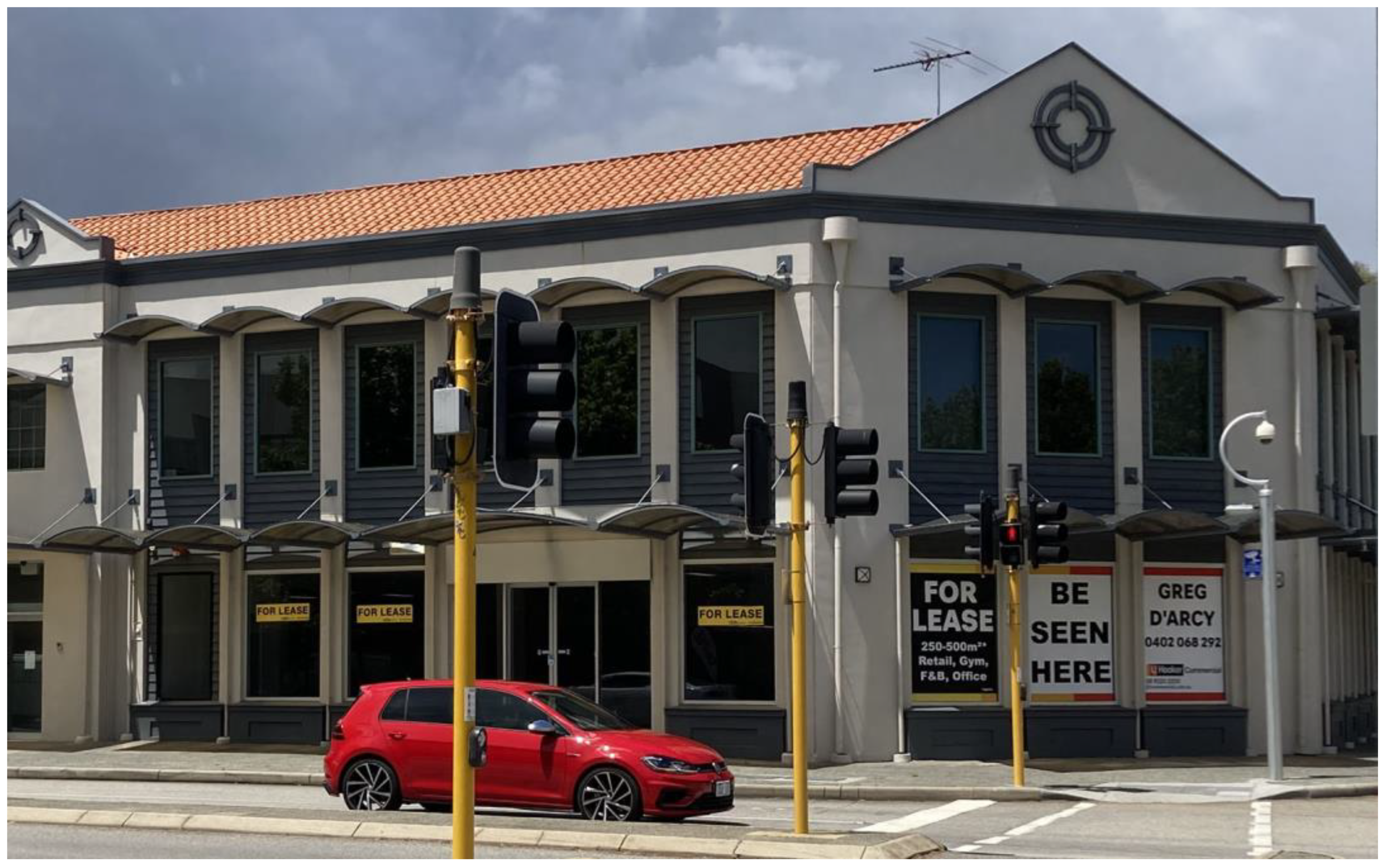
Royal Street in East Perth, Western Australia presents an interesting case study to address this research question. During 2020 and 2021, the COVID-19 pandemic was ravaging cities around the world. In Australia, the cities of Sydney and Melbourne were exposed to long lockdowns of 157 [
16,
17] and 262 days [
18], respectively. Numerous restraints and rules that seriously affected people’s lifestyles, and consequently, the way businesses and streets operated in the city, were put in place. The situation in Perth, Western Australia, however, was very different. After a six-week lockdown in March–April 2020, the State was kept safe with no community transmissions of the coronavirus during 2020 and 2021. In May 2020, dine-in in restaurants, cafés and pubs was allowed, and by June 2020, all gathering restrictions were lifted. There were three subsequent snap short lockdowns, each lasting for four days, namely in February, April and June 2021 (in response to travellers returning from overseas to Western Australia who tested positively to COVID-19). Because of the short duration, they were much less disruptive. The isolation of the capital city of Western Australia from any other large metropolises, combined with a firm border control, resulted in no other serious restrictions imposed on Perth residents. In fact, Western Australia was one of the few places around the world that in 2020–2021 managed to eliminate community transmission of the coronavirus. Although the risk of a lockdown was always present, street-life was expected to return to normal. The centrally located Royal Street represents a good case study of the effects of COVID-19 on the urban environment and local business as it had the opportunity to bounce back and recover from the strict restrictions put in place.
The remainder of the paper is structured as follows. We first explain the link between streets, traffic and business. This is followed by a methodology section which outlines the use of the case study approach and the collection of research data. Royal Street is then introduced as the actual case study and discussed with lessons drawn about designing the urban street environment in a way that is protective and supportive of active communities and flourishing businesses. The findings from the analysis generate the concept of the Minute City, a sustainable spatial pattern supported with appropriate infrastructure that can help with street recovery. Finally, the conclusion stresses the importance of simultaneously designing the urban fabric for sustainable mobility, customer traffic and physical distancing.
2. Streets, Traffic and Business
City streets are capable of providing free-riding benefits that retail business can utilize to survive and to prosper. These include availability of trading space for market entry or the existence of positive externalities for cost reduction which generate location-based benefits. However, the most important free-riding benefit is the flow of people, and it is not a secret that “retailers have always depended on the exposure of passing traffic for their livelihood” [
19] (p. 43).
To have a sufficient flow of customers to sustain business, a street first must be well-connected, linking different places of interest such as the home, work, schools, libraries, train stations and bus stops. This not only reduces transport costs, but also creates adequate traffic for a business to be commercially viable. Trips between geographical points are affected by distance and demand some form of movement which involves a cost, “whether this is actual payment of money to travel by bus, train, or jet, or to transport materials or goods; wear and tear on the soles of the feet; or perhaps the time involved in moving between places” [
20] (p. 20). People moving around also generates traffic, such as motor traffic that a suburban shopping centre is heavily dependent on for its revenue, or foot traffic on which a small family-owned store relies for its existence. A well-connected street network featuring “many short links, numerous intersections, and few cul-de-sacs”, makes “travel distances decrease, and route options and travel modes increase…” [
21] (p. 32). For example, a 5 km drive at 50 km/h to a “big box” shopping centre for a loaf of bread can become a 200-m walk at 5 km/h to a corner shop, if the concept of accessibility were used in preference to mobility [
22]. Shorter, direct travel between destinations promotes more non-motorized traffic which benefits small business. It is also a social equalizer, as the trips are not dependent on being of driving age or having access to a car.
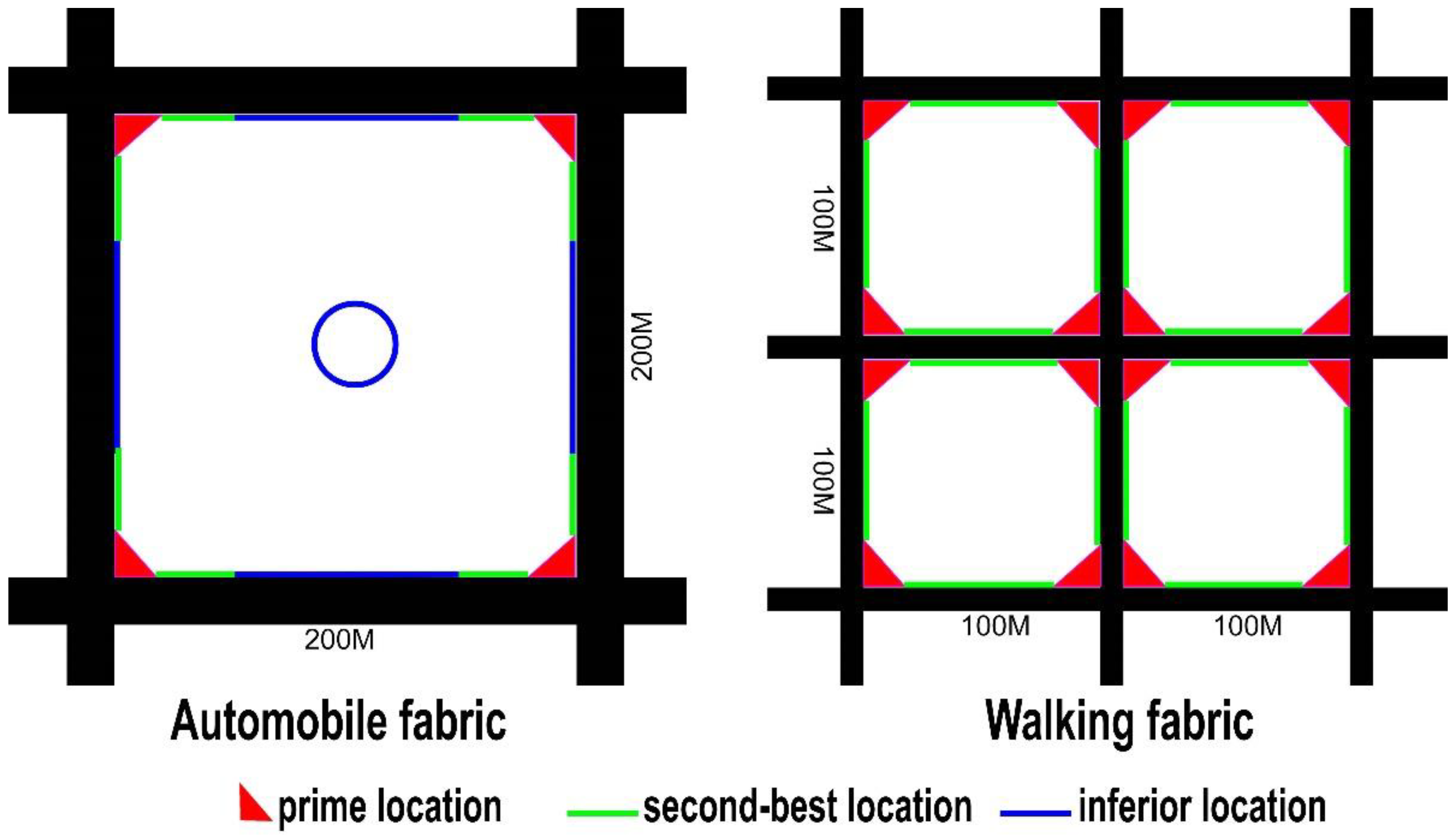
In China, where there has been a lot of new urban development, there is a trading proverb to explain the most desirable location with the highest retail value. It is the “golden corner”—a street intersection where the traffic is the highest and the visibility the best from all four directions. This “golden corner” is followed by the second best or “silver line/edge”—the adjacent storefronts. The least demanded location with a low commercial value is the “grass belly”, the middle section of a long street or a site nestled inside a big block.
Figure 1 compares two street designs and the desirability of different locations within them. The design on the left is based on automobile traffic with business located in a walled community. It has four prime locations (the corners in red), several adjacent second-best positions (the green lines) and a lot of inferior space (marked in blue). Such a design of the retail layout often puts shops or restaurants tucked away in the middle of a large block, and even if aesthetically located near a park, playground or other facilities, they can struggle for existence. By comparison, a better street connectivity with higher intersection density, shorter blocks (ideally 100 m-long or less) and walking traffic, as shown on the right of
Figure 1, offers more prime locations. For their successful existence, restaurants and shops often need to go with the flow and capture the traffic from the public streets rather than rely mainly on advertising and reputation. A walking fabric design also offers many more prime locations for business and face-to-face access to more potential customers.
To further give business a boost, a city street needs traffic calming or pedestrianization to slow down the vehicular traffic and expand pedestrian flow. Plenty of evidence shows that such policies can strengthen the retail location by bringing more pedestrian flow and reducing distances between places of interest [
23,
24]. On the other hand, certain features of automobile dependence are negatively linked to physical or perceived distances, which affect retail location and performance. For example, multiple lanes, widely spaced intersections and heavy traffic increase the waiting time for pedestrians to cross the street. The installation of traffic barriers further prevents shops from benefiting from traffic flow on both sides of the street. Some extreme cases in cities such as Beijing have led to a half-street economy or even the demise of a shopping street because of the decoupling between traffic and business. Heavy motor traffic makes it increasingly impossible to cross the street [
25]. For pedestrians, a simple kerb-side pickup without feeling guilty for jaywalking or traffic disruption, is also impractical. Such street design is “in contrast to the dense and narrow street network… where both the local shops and residents benefit from traffic calming and easy pedestrian crossings” [
26] (p. 11). Some describe the walking fabric as going back to the future [
27], where the town centre re-establishes its prominence with ample opportunities for activities.
Cars are also notorious for their insatiable appetite for space, insidiously taking precious public areas away from pedestrians. For example, “66% of all public space in Paris is reserved for cars. Private cars only move 17% of the city’s population” [
28]. Furthermore, despite the common associations between cars and mobility, most private vehicles are parked for 95% of the time [
29] and a large fraction of this time is in public spaces. Replacing car trips by more sustainable transportation options, such as walking and biking, is further beneficial to business as these people spend longer periods of time on the street and expend more money. For example, a study in Melbourne, Australia showed that bikes generate five times more revenue per hour compared to cars [
30]. As early as in 1979, a survey revealed that in Germany, pedestrianization schemes resulted in substantial growth in the number of pedestrians and business revenues—“141 pedestrianized areas experienced an increase in turnover (83%)” and “153 pedestrianized streets showed an increase in the number of pedestrians” [
24] (p. 23).
Not only does narrowing the street for walking and outdoor trade reduce car dependence and bring more foot traffic, it also helps small businesses such as restaurants to overcome the restrictions on their indoor operation capacity. Considering that a typical restaurant allots 45 to 65% of their space to the dining area, the potential for alfresco dining on the pavement means substantial saving on indoor space and rental costs. Reclaiming the role of streets as a public place that facilitates community life and business activities is a long-overdue necessity which has recently been made even more prominent.
The COVID-19 pandemic-imposed constraints on businesses and social life have been compounded by inadequate urban design of the public realm. City authorities were unprepared as planners and their infrastructure decisions were conflating urban identity and quality of life with the presence of cars [
31]. Under the COVID-19 pandemic’s social restrictions, many urban dwellers started to take the initiative in transforming the city. People realized and started to reclaim part or all of the road space and transformed so-called carparks from places for cars to spaces for outdoor commercial or leisure use [
32]. In cities around the world, pop-up outdoor dining places and bike lanes became a new experiment, occupying spaces that otherwise were carparks or part of the road [
33]. Distinct from strategic planning, such changes are described as tactical urbanism which helps transform the urban environment with quick, low-cost and practical solutions that help develop and maintain social capital in the city [
34].
There is ample evidence about planners and city councils failing to handle competing demands on the public space in the streets during the pandemic, including for bike lanes, green spaces, outdoor dining, delivery services and shared mobility [
35]. Businesses, particularly restaurants and coffee shops, have struggled to stay afloat during the COVID-19 pandemic and then to recover. This particular study based in Perth, Western Australia analyses the changes during the pandemic and the road to a long-term, sustained recovery. We argue for the need to change the way we plan cities by simultaneously designing for accessibility, including sustainable modes of transport, customer traffic and physical distancing. With different coronavirus variants remaining active for the foreseeable future and other commonly transmitted viruses being part of urban life, this new way of designing the city and its neighbourhoods can provide glimpses of hope and resilience against future disease outbreaks, pandemics or even other disruptive events.
4. The Case Study: Royal Street, East Perth
Founded in 1829, Perth was established on Noongar (the spelling of names may vary as the Aboriginal languages are only verbal and there is not yet a uniform convention to transcribe them in English spelling), Aboriginal land around Derbal Yeirrigan or the Swan River [
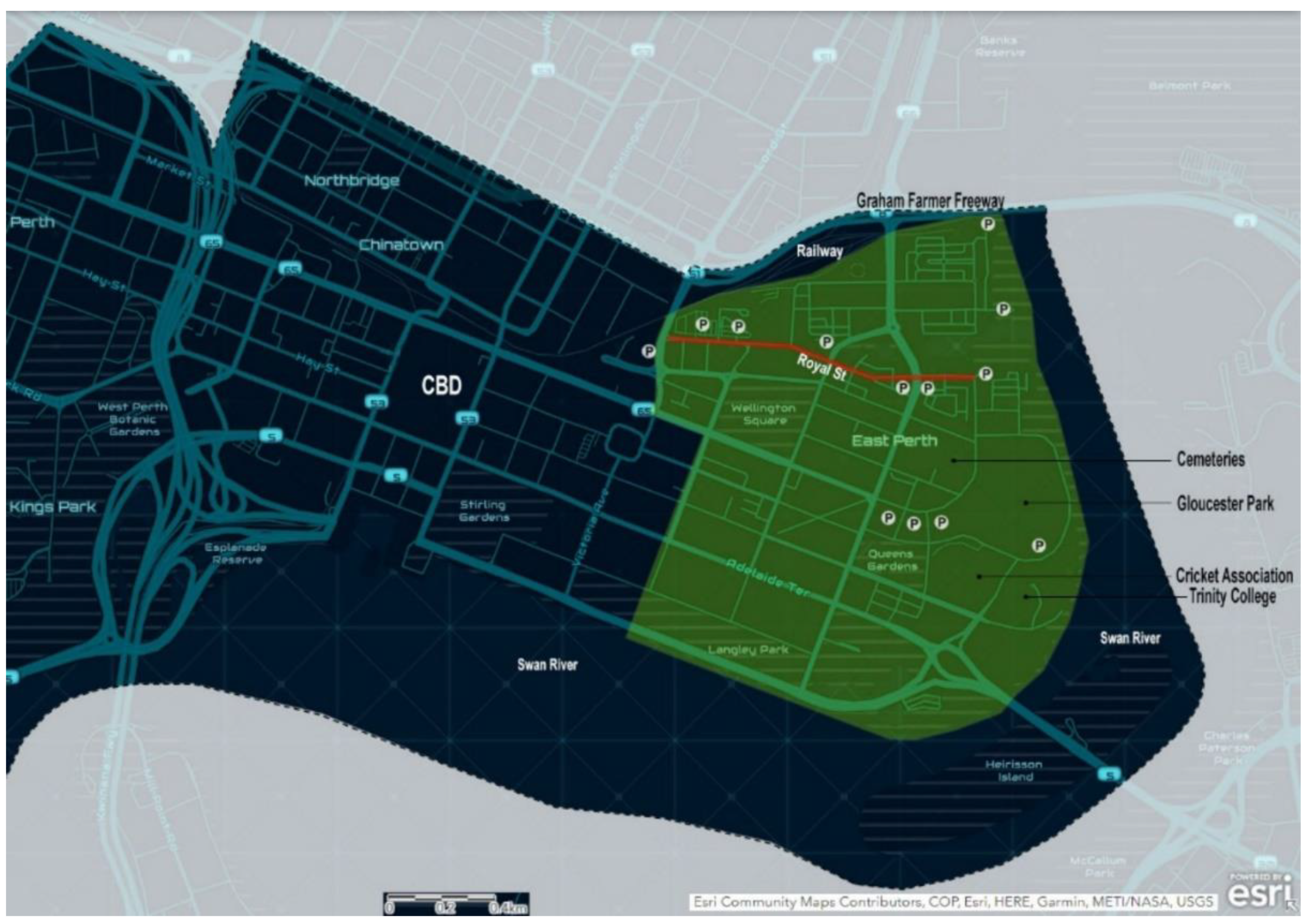
42]. Currently having a population of over 2 million, the city stretches for 125 km along the Indian Ocean on the Swan Coastal plain. Its Central Business District (CBD) is located 10 km inland of the Indian Ocean around the place where the Swan and Canning Rivers meet, towered by Kings Park, one of the world’s largest parks in a metropolitan area (see
Figure 2). Linking the eastern part of the CBD with a park on the beach of the Swan River—Victoria Gardens—and running parallel to a small river cove (see
Figure 2), Royal Street is a vibrant mixed-use area where small businesses, government departments, light industry, shops, a City of Perth-operated carpark, restaurants and cafés are located surrounded by residential homes, home-units and apartments. Victoria Gardens, which is at the eastern end of Royal Street, was planted on the Swan River’s bank in the 1800s. It is one of the earliest parks in Western Australia, where among many of the original trees, artworks celebrate the Aboriginal history and culture of the place [
43], such as the Chranock Woman Mosaic telling a Noongar Dreamtime story.
Initially known as Water Street [
44], the origin of the name Royal Street is unknown [
45], except for the obvious association with the British monarchy. Although the actual configuration of Royal Street has slightly changed throughout the years to absorb what used to be King Street (named after Captain Phillip Parker King, an early explorer of the Australian coast), its importance as a corridor linking the CBD with the river front roughly from west to east, has remained. Royal Street cuts across the suburb of East Perth with a population of around 11,000 [
46]. This suburb also hosts East Perth Cemeteries—the first colonial-era cemetery, located at what used to be the edge of town, where all people who died in Perth between 1829 and 1899 were buried. Representing seven different religious denominations, sections and cultural groups who had their own cemeteries plus an eighth burial ground for “felons” [
47], it is estimated that around 10,000 people were laid to rest there, but only 800 graves are now identifiable, with the others lost due to neglect, decay or malicious destruction [
48].
In the 1990s, East Perth was redeveloped from light industrial (including railway yards) to quality inner-city urban fabric, conceptually influenced by the new urbanism [
49]. Easy access to the CBD and other parts of Perth is further facilitated via public transport—a free central area transit (CAT) bus running on Royal Street, and train and bus services in its vicinity. Royal Street has become an iconic residential address with properties attracting higher prices due to its location.
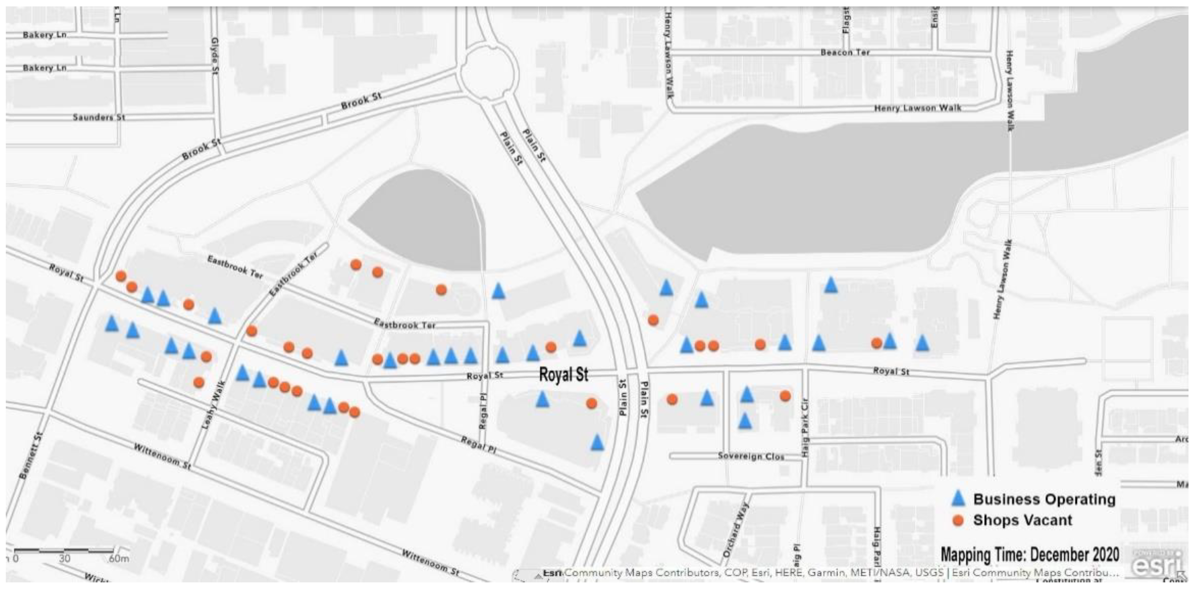
The start of the COVID-19 pandemic seriously affected local business, and this was felt strongly along Royal Street. In total, 25 out of the 52 shops and other commercial premises (from Bennett Street to Victoria Gardens) became vacant or closed at the end of 2020 (see
Figure 3 and
Figure 4). This was in stark contrast to the booming character of Royal Street prior to the pandemic. November–December 2020 was the time when business activities were expected to be at their peak considering the absence of a long quarantine period in Western Australia and the summer holiday season. By looking at the design of the street environment, this study attempts to find some clues about traffic, which might be of help to explain the dilemma of Royal Street and thus to assist in its recovery.
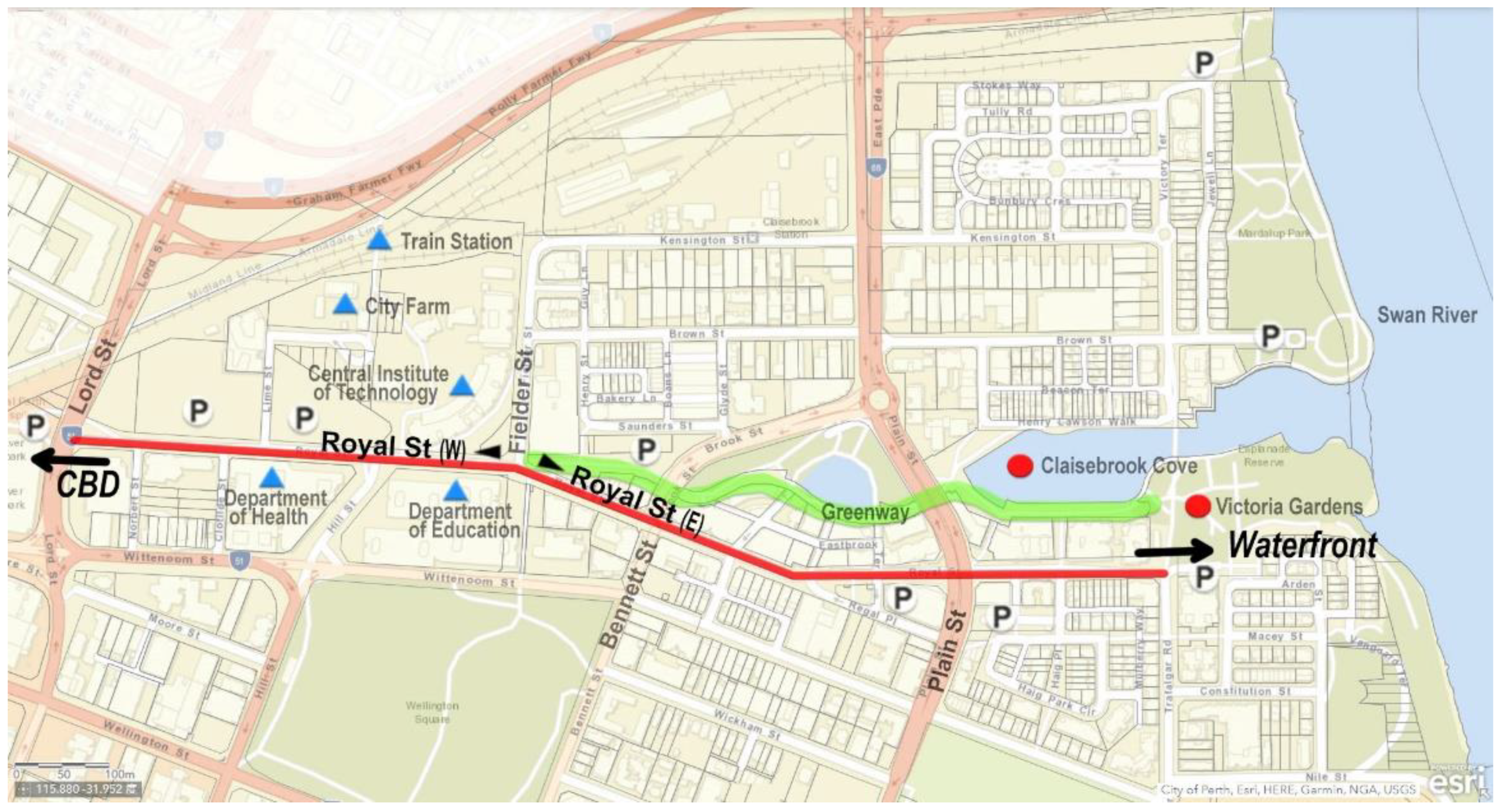
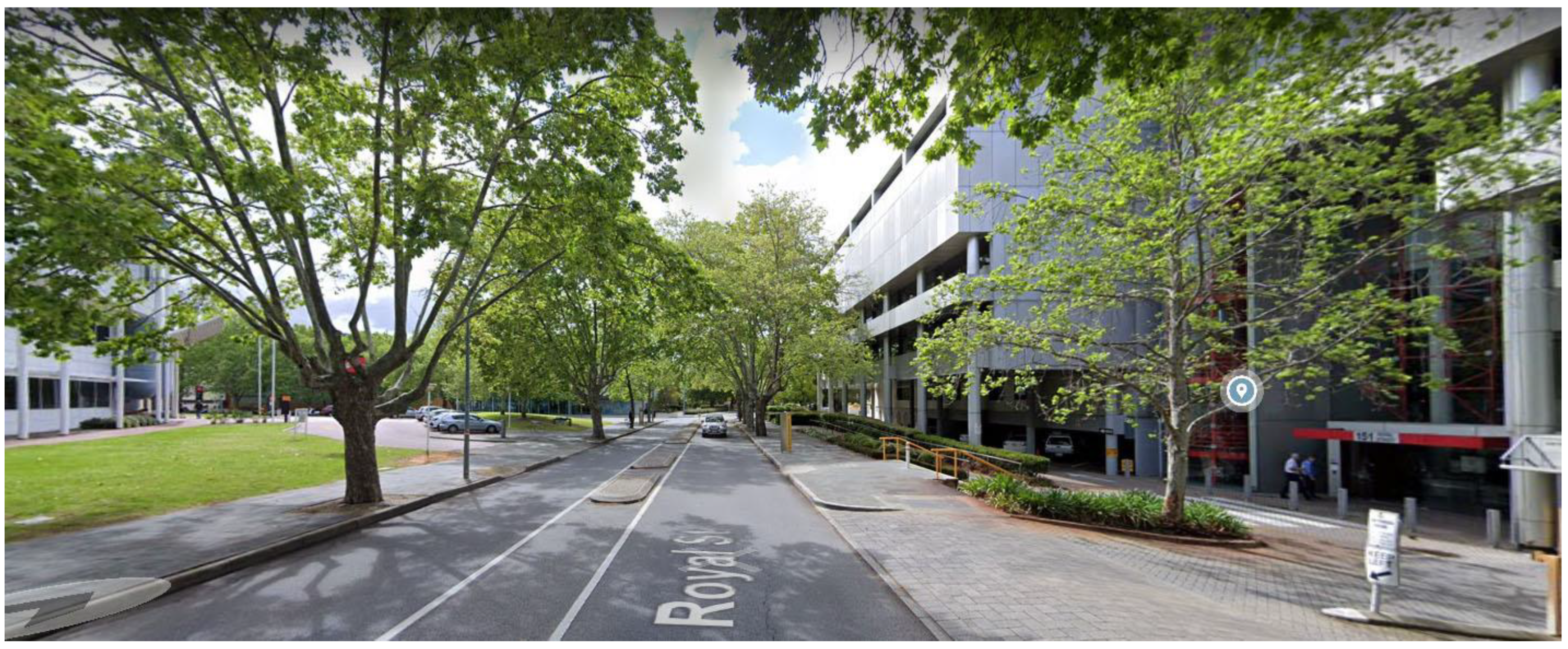
When it comes to the street network and traffic composition, it is difficult to say that the iconic Royal Street is well-connected, particularly for foot traffic. Linking the idyllic Victoria Gardens in the east and having a shops and cafés cluster around Claisebrook Cove in the north (see
Figure 5), Royal Street functions more as a local Main Street that is well-integrated with the tranquil waterfront and the stylish apartment clusters. Looking further, however, the few small blocks around Royal Street seem to be isolated, cut off by vacuum edges such as rail lines, the freeway and mega-blocks, such as the old cemetery, the Western Australia Cricket Association (WACA) ground, Gloucester Park—a harness racing course—and massive carparks among them. Notwithstanding being a stone’s throw away from the Perth CBD in the west, Royal Street feels content with limited customer traffic and its retail ambition stops right at Fielder Street, thus losing its direct business connection to the bustling CBD. This is further exacerbated by its T-junction with Lord Street, which cuts it off from a direct connection to the CBD (see
Figure 6). One of the traffic problems lies in Royal Street’s broader connectedness with other streets. In 1992, Kenworthy and Newman [
50] pointed out that the redevelopment of East Perth could play a vital part in revitalising Perth’s central areas, if undertaken properly.
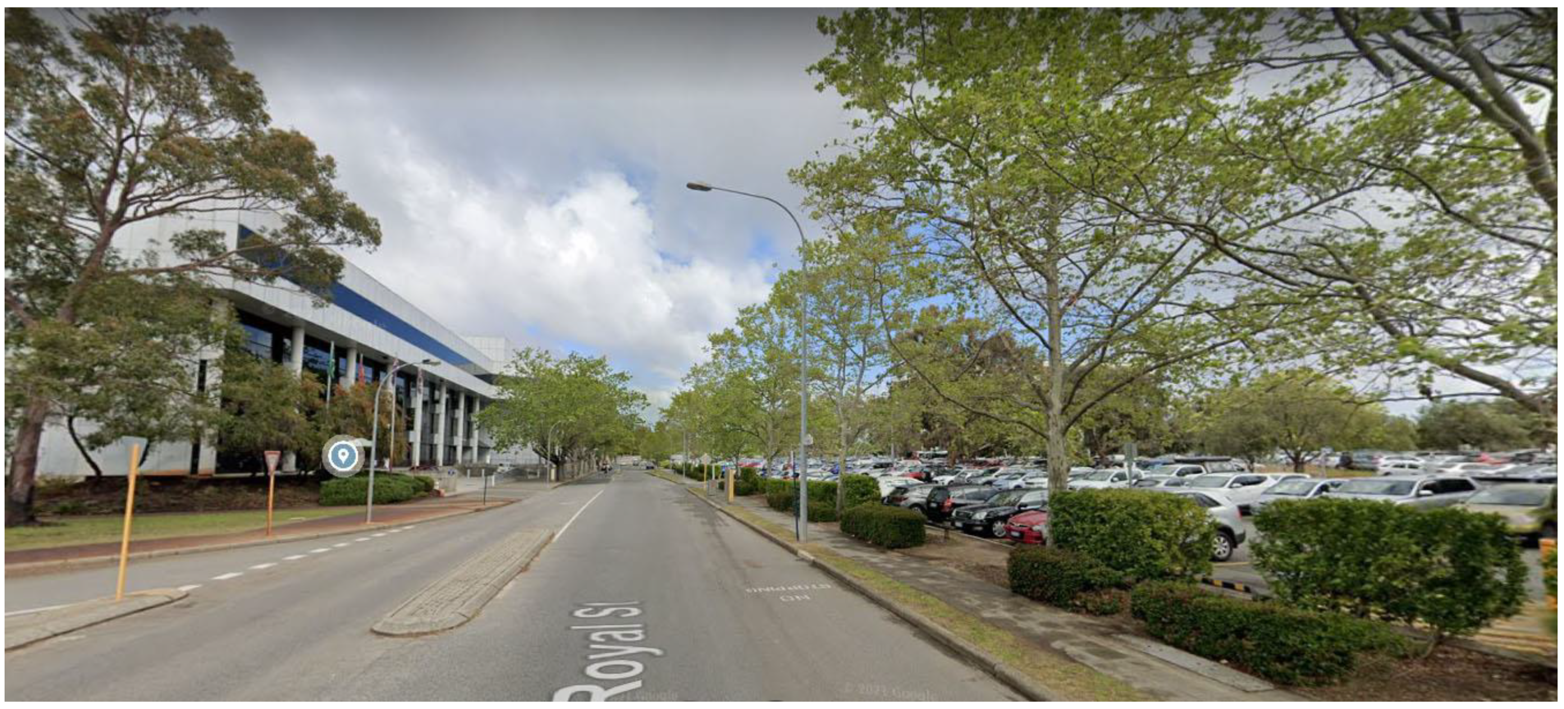
Disguised in stylish apartment living with extensive cycle and walking trails along its picturesque waterfront, East Perth is, in essence, characterised by auto-city fabric [
51], and so is Royal Street, which is surrounded by up to seven public parking lots (see
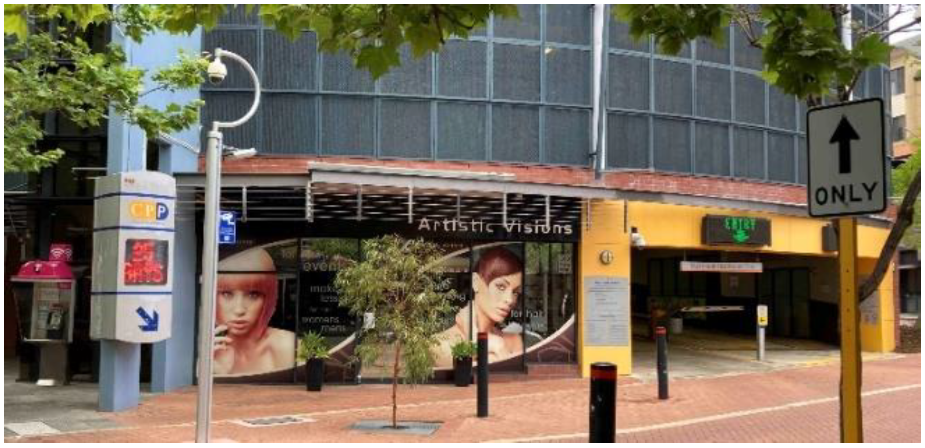
Figure 6), without any traffic-calming practices in place. Walking along Royal Street, it is difficult not to notice the spaces occupied by cars, on the ground and above–ground—from 24 h carparks (see
Figure 7) and parking structures to interim on-road parking and private garages that line the back laneways (see
Figure 8).
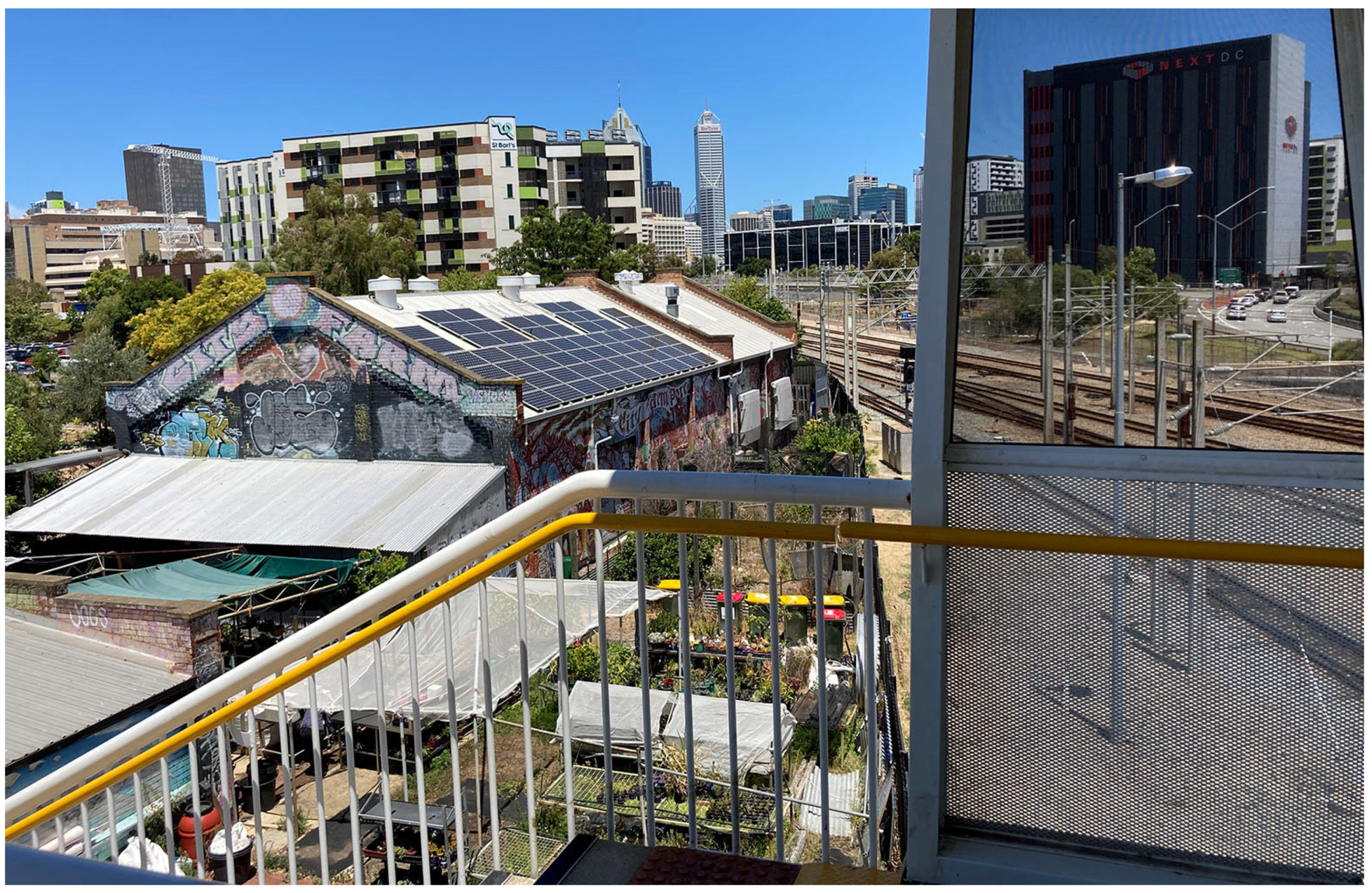
The mere 700 m shopping section of Royal Street, its east section, is not only severed by two arterial roads, but also broken up by driveways, making the pedestrian flow intermittent and potentially dangerous, especially for families with children. Ignoring pedestrians in favour of cars, Royal Street has distanced itself from the nearby Claisebrook Train Station, the popular City Farm—an oasis of urban agriculture (see
Figure 9)—and the Central Institute of Technology, Perth’s largest Technical and Further Education (TAFE) college, disregarding the fact that these traffic generators are spatially right at its doorstep. Such problems of automobile dependence have long been recognized by Jane Jacobs [
52], who looked to attrition of automobiles as a practical solution. The logic behind this is to make conditions less convenient for cars, thereby bringing back street space and non-motorized traffic.
In the case of Royal Street, the focus so far has been on car traffic and to a lesser extent public transport, mainly via the CAT bus, either by improving the connection to the CBD or via transfer between traffic modes. There is no doubt that traffic volume matters to retailing, but what is equally important is how to slow it down and engage with it. Smart retailers know this well and often utilize store layouts to attract and direct foot traffic to where they want it to go, and use endcaps and promotional islands to encourage shoppers to stay longer, see more and buy more [
53]. Likewise, instead of a mere conduit for cars or pedestrians to drive/walk through, Royal Street needs to be an inviting public open space with various anchors for people to stay and enjoy. Excessively wide and empty streets only prompt traffic to rush through without encouraging stopping and allowing people to get out and browse. For instance, amenities such as drink fountains and restrooms provide short stops for pedestrians, while shading and seating support shopfronts to extend their business to the outdoors, which in turn increases dwell time as well as footfall.
Inviting street design and proper website representation can also convert online searches into offline footfall [
54], with Google data showing that 46% of all searches are for local information with 97% looking for a local business and 88% of consumers visiting within 24 h [
55]. The online presence of businesses is as important as their physical existence. However, despite Australia rolling out its National Broadband Network (NBN), which provides fixed-line telephone and internet connection infrastructure, as of January 2022, not all premises along Royal Street in East Perth were NBN-ready. The available option was 5th-generation wireless mobile network (5G), which is yet to deliver reliable services across Australia [
56].
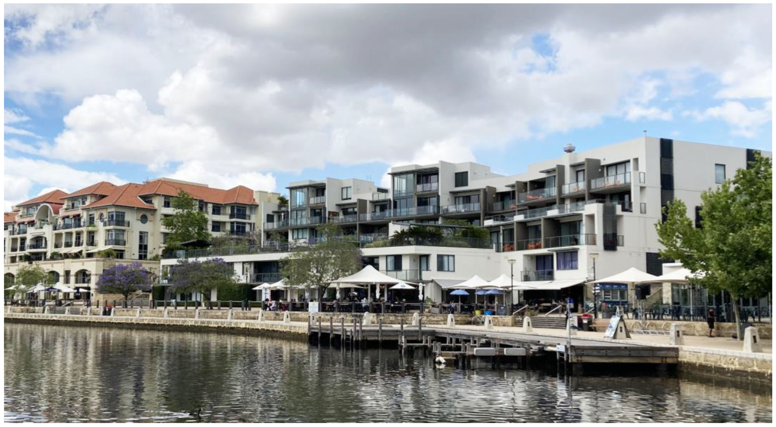
The alfresco dining by Claisebrook Cove (see
Figure 10) is a good example of attractive street design. An active street front is essential for businesses: “When commercial tenancies open onto the verge and the footpath amenity is improved with landscaping, it creates a more comfortable environment for pedestrians who are now more likely to spend more time and potentially more money in these businesses” [
57] (n.p.). Public buildings such as libraries, schools or city halls could also serve as anchors similar to commercial ones, drawing substantial foot traffic and making people linger for a while. Unfortunately, this is not the case for many similar establishments along Royal Street—the Central TAFE College, Department of Education (see
Figure 11) and Department of Health (see
Figure 12) appearing to be somewhat isolated with restricted access for pedestrians. Potentially, they can choose to open their most valuable ground floor for commercial or other public use, rather than parking.
To further exploit people traffic, it is advisable to spread the flow of shoppers across the day and extend it to night-time, which would help mobile vending as well as fixed shops along Royal Street. Street vending and the night-time economy are commonplace in many tourist/visitor–oriented and attractive cities around the world. Characterized by periodic markets, pop-up stores, food trucks and hawkers chasing the pedestrian flow, such an economy creates a beat which is equally attractive to dwellers and visitors. Hernandez [
58] (n.p.) eloquently describes this for Los Angeles: “Filling streets with the smell of grilled meats, makeshift lights and chatter, these small business owners activate our streets, provide culturally relevant foods that tourists flock to and create opportunities for a diverse group of people to interact with each other”. Such a vibrant economy provides local business opportunities and generates a stable revenue stream [
58]. In Thailand, street vending is very common and “70% of fixed vendors had worked as mobile vendors earlier” [
21] (p. 38). Prolonged trading time along with widened pavement not only eases concerns over congestion and safety, it also provides market entry to mobile vending, which has the inherent advantage to better catch and utilize traffic flow.
Last, but not least, Royal Street could use digital support as well as physical infrastructure to leverage network traffic. It is reported that in 2020, just over one in five accommodation and food businesses in Western Australia were satisfied with their internet service quality [
3]. A growing number of retailers across the globe have an online presence, generating big sales revenue, especially during the COVID-19 pandemic. Offering digital trolleys and door-to-door delivery not only avoids indoor customer crowding and the spread of disease, but it also increases sales without missing out on potential visitors when physical stores are closed or restricted in trading hours or capacity. According to Johnson [
59] (n.p.), “in 2020, nearly 41% of customers said they were currently shopping online for things they would normally buy in-store”. Getting businesses listed on websites such as Google or Facebook, and providing click-and-collect services, would also drive more traffic to the physical location. Research shows that “about a third of shoppers would prefer to have an item delivered to a location other than their home…” and many “bought something else during their trip to the store” [
53] (n.p.). This brings more foot traffic in-store. Furthermore, “blurring the boundaries between the physical brick-and-mortar space and virtual eCommerce stores” is becoming the future of the retail industry [
60] (n.p.). Digital notifications about discounts can be delivered through mobile devices which aim at bringing more people to the physical stores [
60]. The locations of these businesses need to be convenient and attractive to all types of pedestrian traffic. It seems that Royal Street has not yet capitalised on all of these opportunities and remains vastly underutilised. Its COVID-19 recovery has been conflated not only by the health-related threats but also by factors linked to the urban design of public places and traffic.
5. Discussion
From the case of Royal Street, it is not difficult to see that traffic amelioration can contribute to both the containment of COVID-19 and business recovery. First, from the seamless online transactions and streamlined delivery or pickup, the growth of e-commerce and virtual traffic not only reduces the number of vehicles needed on the streets but avoids unnecessary physical contact as well. Second, extended trading time and widened pavements can make room for street vending, easing the pressure from business restrictions related to indoor operation capacity. Third, treating streets as public open space (POS) assists in the diversion of traffic that otherwise overly concentrates in big-box shopping sites. Splitting the volume of traffic and reorganizing it around various anchors help to better control the flow, allowing for disease control as well as contributing to an efficient conversion of revenue from the improved traffic of shoppers.
Traffic improvement and virus control have much in common, and flow control is one of these factors. It is common sense that having more domestic and local traffic makes COVID-19 situations less complicated and more controllable than long travel that potentially turns asymptomatic virus carriers into super-spreaders, who are often found traversing a greater part of the city and visiting multiple places. This has been the case with many COVID-19 exposure sites in Australia and around the world. Urban design needs to help keep people safe and support local economies. Realizing this, Baltimore, USA launched the Design for Distancing initiative, which aims to reconfigure the public street space to guide traffic for the needs of the beleaguered small businesses, while better observing hygiene requirements [
5]. According to these urban planners: “When we step outside of our homes, safely patronizing neighbourhood stores, services, and restaurants will be crucial to our total recovery. When our small businesses thrive, our residents and neighbourhoods do also” [
5] (p. 6). In this respect, it is essential to transform long-distance travel into short-distance local and domestic trips, which need a vibrant street network in place that is interconnected digitally, temporally as well as physically. This requires allocation of sufficient land to street development that allows for more direct mixed-use right at the street level and investment in fast and reliable internet and broadband to facilitate the convergence of the physical and virtual economy.
Once the connection between traffic and infectious diseases is understood, it is important to recognize the relationship between traffic and location. In business, “knowing the terrain can make all the difference between winning and losing, success and failure” [
61] (n.p.). “Location, location, location” is a mantra that is often used to stress the importance of location—the economic terrain in starting a business [
62]. Retailers are especially seeking various advantages of good location, such as spatial proximity to customers or suppliers. One of the major advantages lies in the location’s capability to attract a substantial flow of traffic and turn part of it into revenue owing to its superior accessibility and visibility. According to Nicasio [
53]: “More traffic means more opportunities for sales and customer engagement, which in turn leads to higher revenues” (n.p.). The closer the business to a place with high traffic, the more desirable the location is. However, this can also mean high rental cost to the business due to fierce competition for premises located in a well-trafficked area. Retailers who are willing to pay a high price for a desirable location tend to believe that they will profit from traffic—the core of business location. This is a well-known situation: “The location-rent curve indicates land uses compete for the most accessible location and are ‘sorted out’ on the basis of their location rents which reflect their ability to pay for a particular site” [
20] (p. 43). The question is whether “the location” is fixed or whether this can change for the good of small business without soaring rental costs.
There is a belief that: “You can change a property, but not its location” [
63] (n.p.). Hence, location is permanent. It may be true to a large extent but through zoning and planning we have seen many examples of when the characteristics that make a location attractive change. Too often, for the sake of congestion alleviation, present transport policy is literally closing down streetside shops, not to mention other informal or mobile retail modes, with the aim to reduce the impact on the free-flow of traffic, or driving customers into the big-box stores at the local mega-plaza with seas of parking bays. In the name of protecting business interests from the oversupply of retail floor space, current problematic retail planning is actually practising retail rationing that is based on “scientific” prediction, strict hierarchy and “precise” provision of retail areas with designated catchment zones. More often than not, “it is the lease income from the shopping center’s smaller inline retailers that, in effect, subsidizes the anchor” who usually receives “either free land or deeply discounted leases” [
19] (p. 32). Losing their natural ground—the street—small businesses are consequently having a difficult time finding affordable good locations near homes with free usable traffic. It is small retailers, rather than big ones, who are more vulnerable to the high rentals associated with shopping centres and malls where high traffic comes at an extra price. However, as discussed previously, traffic can be improved and free to use in public streets.
Furthermore, location can change in one way or another as time goes by for various reasons. For example, locations such as the crossings of major transport routes may consolidate their positions over time by catering to traffic flow passing along either route; such prime locations can soon lose their attractiveness with a closure or rerouting of a highway or railroad [
19]. Jane Jacobs also describes a force of self-destruction “purely as a result of being successful” which “causes our downtown continually to shift their centers and move” [
52] (p. 242). To withstand this force, she suggests “the sheer supply of diversified, lively, economically viable city localities must be increased” [
52] (p. 255). In other words, the urban fabric does not necessarily need the highways reinstated with heavy vehicular traffic and pollution to consolidate the retail positions. An increase in the provision of well-connected walking fabric, for instance, can potentially eliminate the undesirable locations and quadruple the “golden corners”. Partnering with social influencers and benefiting from massive visits on platforms, such as Taobao in China, give rise to many online celebrity shops, which have substantially changed the overall business location previously constrained by physical geography. Sometimes, small interventions can succeed, and can be as simple as keeping the shopfronts clean and well-maintained to increase kerb appeal, or just placing planters at the entrance of the street or changing traffic signs to discourage cars.
The supply of streets that are open to business and offer more affordable locations can generate the Vernon–Chinitz effect on entrepreneurship, where small businesses benefit more from banding together along the street than big firms do [
64]. To start a business, an entrepreneur must in the first place take costs, demand and scale into consideration and choose the right location that offers a favourable external environment. Historically, markets emerged first along roads not only to take advantage of the flow and concentration of goods, people and information but also for the constant availability of retail space of all kinds that can be taken up or discarded to meet different needs—fixed or mobile, permanent or periodic, formal or informal. Urban fabrics prior to about 1850 were walking cities, and so all roads were pedestrian-based, or at best based on traffic moving at animal-drawn speeds, less than about 8 km/h [
51]. This is very different from the automobile-dependent fabric. Gibbs [
19] (p. 47) in his book “Principles of Urban Retail Planning and Development” explains:
“The timeline for locating a space, negotiating a lease, obtaining the necessary government approvals, and coordinating the store’s construction is too unpredictable for most small businesses. The uncertain and often subjective building permit process required in most cities is an unreasonable hardship for the independent and often undercapitalized store or restaurant owner. In many cases, the business owner must pay rent (with no sales revenue) for months while building a new store.”
While it is sad to see a business fail, such failures are unavoidable and sometimes a necessary evil, not just for a quick exit to reduce the cost, but also for a fast market entry for a new firm. The combination of traffic and trade, and the easy market exit and entry, can change the general location of the street and lower the barrier for businesses to enter the marketplace by saving on transaction costs such as land, floor area, transport and time.
In addition, with the congregation of firms into clusters along public streets, individual businesses are more likely “to derive cost economies at second-hand from scale factors operating outside themselves… without necessarily raising their own scale of production” [
20] (p. 287). Take a cluster of restaurants as an example; the collective demands lead to economies of large-scale purchasing, thereby obtaining favourable rates on items such as food products, packaging, napkins and restrooms. Even better, it also comes with the economies of common reserves that need far less capital and space to be immobilized in inventories unlike large firms which usually have to prepare for unexpected delays in delivery or temporary shortages [
20], as has been occasionally the case during the COVID-19 pandemic. Because of a high level of aggregate demand for fresh produce or other ingredients, food suppliers can use this steady flow, combine shipments and thus make daily delivery economically viable, even at short notice. In other words, individual restaurants, cafés, pubs and bars enhance the location via combined demands and traffic, turning the tables on larger firms yet without the burdens of being big. The vision of a 15 min city (e.g., C40 Knowledge [
65]) is expected to rediscover the business location of streets by helping small businesses to exploit the local traffic, establish linkages and benefit from positive externalities. Some of the advantages the 15 min city offers are a boost to the local economy, reduced travel-related emissions, a healthier environment and more equitable, inclusive and stronger communities, helping people to live with COVID-19 and build better [
65].
After discussing the street, the economic terrain for small business, and the favourable timing for a change, namely the pandemic reboot, the slogan also needs to change to “people, people, people”. Not only are people the core of traffic and location, they are also the key to street recovery. The thriving street vending in Los Angeles and the legalization that followed are a case in point that shows the extensive support from the community, without which nothing could have been accomplished. Failing to mobilize people, it is unlikely that cities can fundamentally change the business-location model and restore the glory of streets, especially given the entrenched car-centric, retail rationing system in place. From garage sales to the Marketplace in Facebook, from home-based businesses to a stall economy, it seems that everybody has something to sell. In fact, 62% of Americans expressed a desire to own their own business [
66]. Given that entrepreneurship is playing an increasingly important role in modern urban growth, it is time to ask what a city could offer to its citizens to encourage local enterprise. In addition to the mere shopping centres and mega-structures, we need more city streets and pavement that are open to entrepreneurship where everyone can find their niche and fulfil their business dreams.
In finding an alternative route to the problematic approach to retail and transport planning, we find some inspiration from the activist website ParCitypatory [
67] (n.p.) about tactical urbanism—“a city and citizen-led approach to neighbourhood building using short-term, low-cost, and scalable interventions intended to create long-term change”. From pop-up bike lanes to semi-enclosed “streateries” that keep emerging across the globe, a truly community-driven development is gaining momentum which is characterized by “crowd sourced rather than close sourced, entrepreneurial rather than bureaucratic, networked rather than hierarchical” approaches [
68] (p. 25). Active citizens know well that it is better to put the fate in one’s own hands than place everything in the hands of a few licensed professionals. If we cannot accommodate the rising demand for shopping locally and safely in a timely manner, the mounting cost of inaction is no longer limited only by business failures and job losses. It also means that more lives are at stake from the threats of diseases, vehicles and climate change.
Recovery in the age of COVID-19 means street design that caters simultaneously for sustainable mobility, customer traffic and physical distancing, while protecting the neighbourhoods and improving the quality of life and well-being of urban dwellers. The case study of Royal Street, East Perth in Western Australia shows that a lot more effort needs to be put in place to bring all these aspects together.
6. Results and Findings
This case study analysis shows that Royal Street was not able to recover after the restrictions from the COVID-19 pandemic were lifted. The contributing factors were not only related to the business environment, but also to the street setting, which was not designed to be resilient and cater simultaneously for individual health, economic prosperity and customer mobility. Any successful street recovery is related simultaneously to traffic amelioration, improvement in retail location and the containment of infectious diseases, which require various infrastructure to be put in place (see
Table 2). This infrastructure needs to cater for the physical, informal, digital and social characteristics of the streets to create a thriving and resilient urban environment.
Table 2 summarises these characteristics and relates them to improvements in customer traffic, retail location and disease containment.
Will the 15 min city be the needed sustainable spatial structure to truly simultaneously promote health, prosperity, equity and resilience? It is indeed an improvement from the present mobility-centred spatial pattern characterized by car dependence and the sprawled suburban fabric as shown in the 20 min city of Melbourne, the Parisian 15 min city or Barcelona’s superblocks [
69]. However, such a model hardly touches the social or informal infrastructural characteristics that small business needs. It is also still based on a top-down approach, mainly from the perspective of physical and transport planning. While claiming to be a city of proximities where everything a resident needs can be reached within a quarter of an hour by foot or bike, the 15 min city concept actually pays attention mainly to accessibility, with the focus on travel options, travel time and comfort via setting up vehicle barriers in a few chosen streets or installing cycling paths on neighbourhood greenways (see
Figure 13).
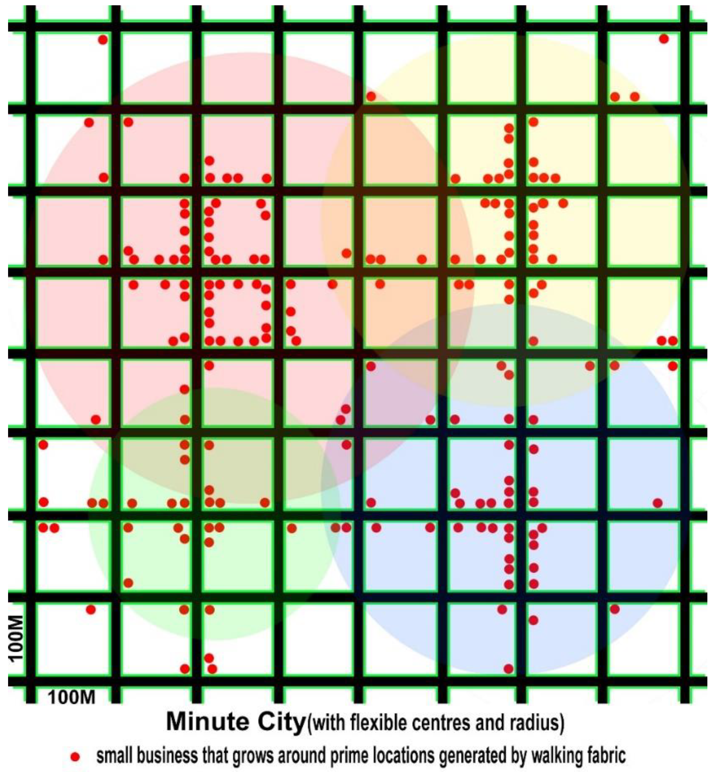
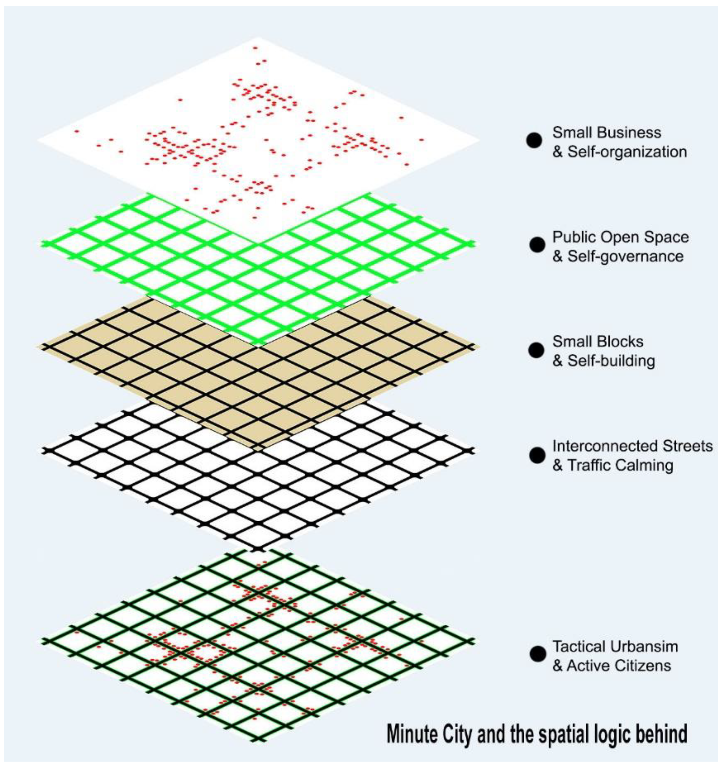
The concept of the Minute City is thus being put forward by this study not just to give the struggling small business full support but also to respond to the ongoing health and sustainability crisis of the planet (see
Figure 14 and
Figure 15). In comparison to the 15 min city, the Minute City incorporates all infrastructure characteristics listed in
Table 2 through which small business can gain access to customers and support street recovery. On the one hand, it is a real proximity-focused spatial pattern without the imposed 15 min radius of 500/800 metres. Instead of getting to and from destinations, such as the shopping centre, park or other places of interest in a well-ordered hierarchical system of urban amenities, the Minute City sees the street space right outside our front doors as a multi-purpose, public open space (POS) and not just movement corridor. This breaks the spatial separation between the journey and the destination, and also opens up opportunities for small business, local employment, shopping, street play and for a safer, resilient and self-sustained community.
On the other hand, the Minute City as a new spatial pattern is informed by a complex adaptive system (CAS) perspective and relational ontology [
70]. It can bring socially driven transformation by incorporating tactical interventions and self-organisation into spatial planning. Rather than being physically adjacent in identical walled communities with a similar shopping-scape that features nonplace and almost stops growing, neighbours and small business owners in the Minute City are connected by common interest and can make small and everyday changes to their immediate environment, improving together their location and creating neighbourhood centres. Unlike the fixed 15 or 20 min slogan, the Minute City can involve 1 min or 15 min of walking, largely dependent on the shared vision of the local residents and the efforts they put in, in addition to the constantly changing external economic, social or public health environment.
As a micro-spatial approach commonly seen in organic ancient towns, the Minute City is not without its challenges in the present-day context. The current hierarchical retailing system that is embedded in the auto fabric reveals “the political economy of urbanism” where “(l)ocation decisions… are not the outcome of the free play of market forces” [
71] (p. 197). Barriers exist not only in the entrenched pro-car political economy and the ubiquitous automobile culture [
72], but also in the land use and spatial planning system which has been influenced by and is acting on the unrealistic assumptions of traditional retail location theories [
71,
73]. Instead of valuing the combination of travel and shopping along a linear market that widely existed in traditional human settlements, today’s uniform market centres with rigid catchment areas or a concentric zonation of retail types typical in Christaller’s Central Place Theory or Haig’s Bid Rent Theory [
74,
75], have fundamentally been built on wheels. They are determined by the simplified measurement of transport cost or accessibility and ill-prepared to deal with present-day priorities. Such unsustainable economic organizations totally ignore other human needs, including exercise and socialization that are taking place synchronously on a routine shopping trip, not to mention taking into account the ongoing shift of human attitudes towards mobility, retail and the urban environment brought out by the pandemic and climate emergencies.
Rather than taking a temporal and dynamic perspective derived from the numerous agents that transform a city into a complex system [
76], a mere physical/spatial approach has been extensively adopted. It is static, fixed and features a dichotomy between the consumer and the good/service supplier. In the scenario of the Minute City however, a blurred and overlapping boundary can be expected between living and retailing, as illustrated by Wen et al. [
77] in the case of innovative streets/districts. The Minute City is not only for the self-organization and adaptation of individual housing and neighbourhood streets for commercial and public use, but also for shared interests and mutual support between local residents and small retailers. Without disrupting the existing system, overcoming car dependence and incorporating tactical intervention critical to the working of the Minute City, are less likely to happen.
Despite the challenges, the good thing about the Minute City is that “the detailed outcomes of such a system cannot be determined in advance but rather ‘emerge’ from practices of adaptation and self-organisation” [
78] (p. 355). Instead of sticking to specific spatial structures and demanding planned outcomes, the Minute City places a premium on the embedded do-it-yourself DNA which gives citizens the individual right to the city in an incremental, piecemeal strategy. Notwithstanding the unpredictable nature of a complex urban system, this new pattern creates a more diverse and fairer environment for all possible retail formats, mobility options and most importantly, active citizens, by integrating not just the journey and destination but the means and ends as well. Such a sustainable spatial and social pattern, therefore, can be expected to contribute to the broader sustainability agenda of carbon neutrality, urban resilience, sense of place and community cohesion in addition to street recovery. In this respect, the Minute City originating from this study takes the 15 min city concept one step further with a totally different spatial logic in its core, thus forming a research and practice basis that is open-ended, ready for new additions in the future.


