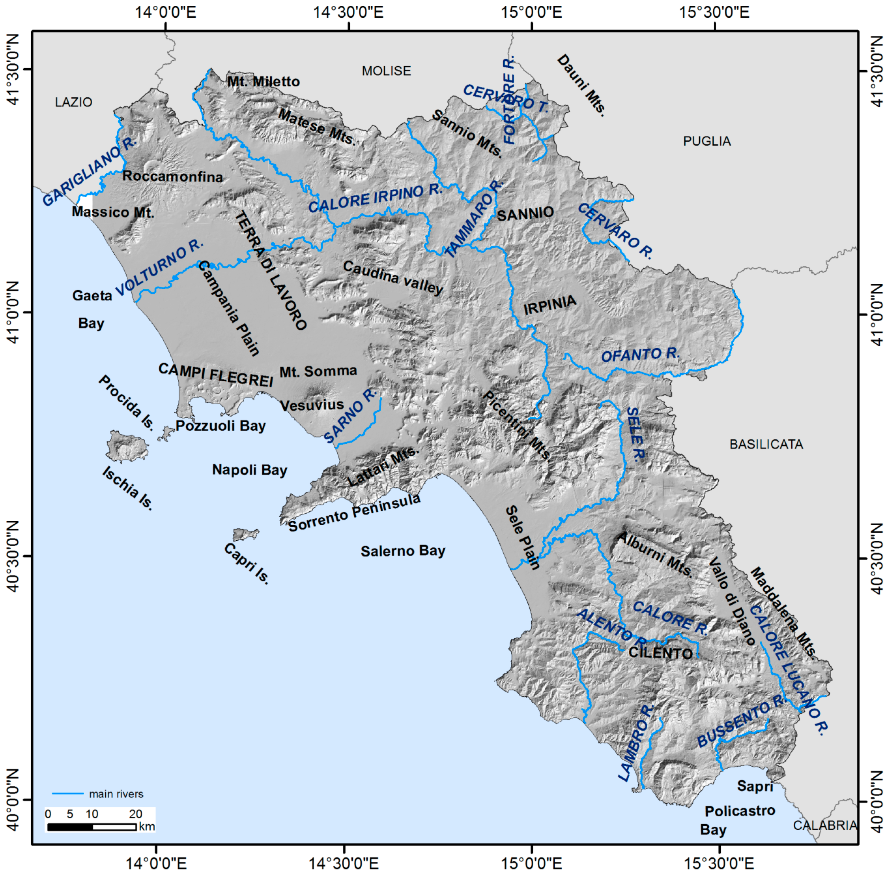
In the following, the large scale ground deformation trends occurring in the different sectors (coastal plain, inner plain, Apennine sector, volcanic areas) of the Campania territory were analyzed in light of the available tectonic, volcanological, hydrogeological, geomorphological, and land use data. In addition, some examples of local scale ground deformations are described to show the potentiality of the used approach.
5.1. Coastal Plain Sectors
The Campania coastal plain sectors fall within the passive continental margin of Tyrrhenian Sea affected by a long-term tectonic subsidence process characterized by large-scale downward movements [
27,
28,
61] with an average rate of about –0.2 mm/yr [
62]. The analysis of the vertical component of ground deformation within the main coastal plains (Garigliano, Volturno and Sele rivers alluvial coastal plains) highlights the presence of wide low coast sectors characterized by strong subsidence movements with −2.5 mm/yr average rates, while Sarno and Alento rivers alluvial coastal plains show lower average rates (ca. −0.5 mm/yr).
The subsidence of alluvial coastal plain can be considered as a natural process mainly due to the compaction of the alluvial sediments infill under the lithostatic load, and the anthropic influences due to water pumping and urbanization loads are only additional factors that locally enhance the subsidence effects [
17,
18]. In Volturno, Sarno, and Sele river plains urban areas the subsidence-induced ground displacements due to groundwater withdrawals have relevant consequences to the exposed facilities [
63,
64]. The coastal subsidence phenomena are contributing to increasing the exposure of the subsiding low coastal areas to hazards related to inundation and erosion processes, and may cause a further increase in future relative sea level rates at local scale [
17,
65].
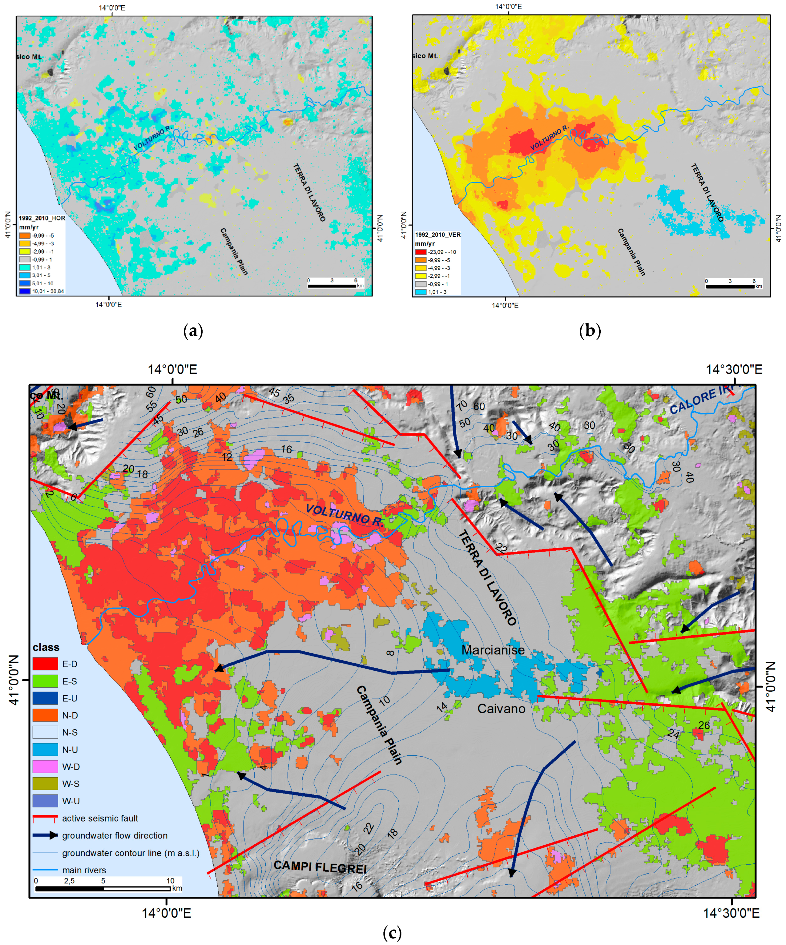
The vertical displacement values obtained for the Volturno river plain show a significant subsidence in the central axial sectors (−2.5 to −22 mm/yr) and in the river mouth area (−2.5 to −8 mm/yr). Moderate uplift is detected in the eastern part of the plain (+0.5 to +2.0 mm/yr), whereas other sectors of the study area are characterized by moderate subsidence and/or stability. A general eastward trend is also recognized (
Figure 9).
The subsidence recorded in the Volturno plain is mainly a consequence of a natural process related to the compaction under the lithostatic load of the fluvial and palustrine deposits that form the alluvial plain. The magnitude of the recorded subsidence has been found to be greater when thick peat layers occur in the subsoil [
18]. The anthropic influences (e.g., water exploitation and urbanization) is able only to locally increase the subsidence effect [
18], while in some sectors the negative balance between the water recharge rates of the Volturno hydrographic basin and the drainage operated by the artificial channeling, related to industrial and intense agricultural activities [
5,
66], may have larger effects on subsidence rates.
The uplift recognized in the eastern sector of the plain is related to the interplay between tectonic activity and hydrogeological conditions (
Figure 9). The uplift can be due to the action of an E-W oriented active fault that bounds the area to the south [
18]. Besides, the study area is characterized by a porous multi-layered aquifer system, formed by volcaniclastic and alluvial deposits, and the groundwater circulation can be considered unitary in the aquifer system. If the local hydrogeological conditions [
67,
68] are considered, the area is located on a minor groundwater divide (i.e., Caivano-Campi Flegrei,
Figure 9) that is recharged by lateral groundwater flux coming from adjoining carbonatic aquifer sectors made by the calcareous massif bordering to the east the Campanian plain. In these conditions, the water fluxes may locally increase the soil pore pressure causing local soil oversaturation, which could be able to partly explain the local uplift observed in the Marcianise-Caivano sector.
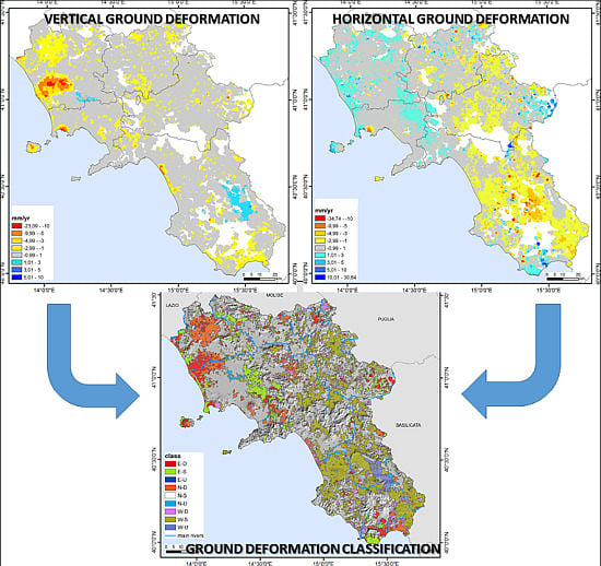
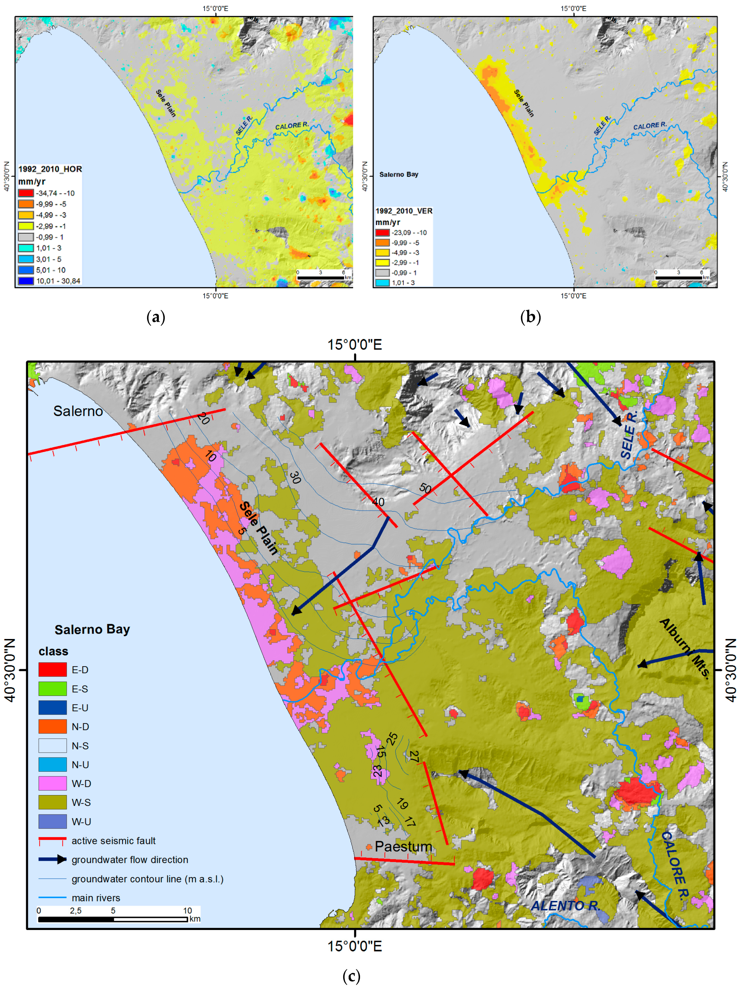
The ground deformation components and classification (
Figure 10) show that the coastal sector of the Sele Plain is characterized by a general westward horizontal deformation and a complex vertical pattern, validated by GPS surveys [
17]. The northern and central sectors of the plain are characterized by relative subsidence rates of about −3 to −7 mm/yr along the coastline and by stability in the hilly inland area; around the Sele river mouth, a narrow area with subsidence rates up to −8 mm/yr is present, while the southern sector is characterized by general condition of stability with minor subsiding areas.
The vertical ground deformation pattern is correlated with the non-uniform stratigraphy of the coastal Quaternary infill because of the presence of layers of clastic sediments with different thickness and degrees of compaction in the two sectors. In detail, the subsidence is higher in the northern sector of the plain, where the Quaternary alluvial-coastal deposits are thicker because of the structural asymmetry of the graben, while in the southernmost sector the rates are the lowest recorded in the plain due to the minor thickness of Holocene deposits and to the presence of very thick sedimentary bodies of travertine [
17]. These differences in ground deformation rates expose the northern and central sectors of the plain to higher levels of inundation and erosion hazard than in the southern sector [
17]. The contribution of the local tectonic deformation pattern could suggest prevailing dip-slip movements along the NNW–SSE striking faults and the E-W trending faults bounding the Sele coastal plain [
5].
Sarno and Alento river plains show lower rates of subsidence in the coastal sectors (
Figure 5) [
65]. The Sarno river coastal plain is characterized by moderate subsidence (up to −5 mm/yr) only near the river mouth, while the Alento river coastal plain shows low subsidence rates (up to −2 mm/yr) in the northern sector, while the coastal narrow strip displays stability. Along the Alento River course, a hot spot of subsidence (up to −3 mm/yr), developing 1–2 km inland, is more evident.
5.2. Volcanic Sectors
Ground deformation in active volcanic areas of Vesuvius, Campi Flegrei and Ischia has been extensively studied with PS-InSAR techniques (in [
5,
14] and references therein), while no ground deformation analysis has been done about the not active Roccamonfina volcanic system.
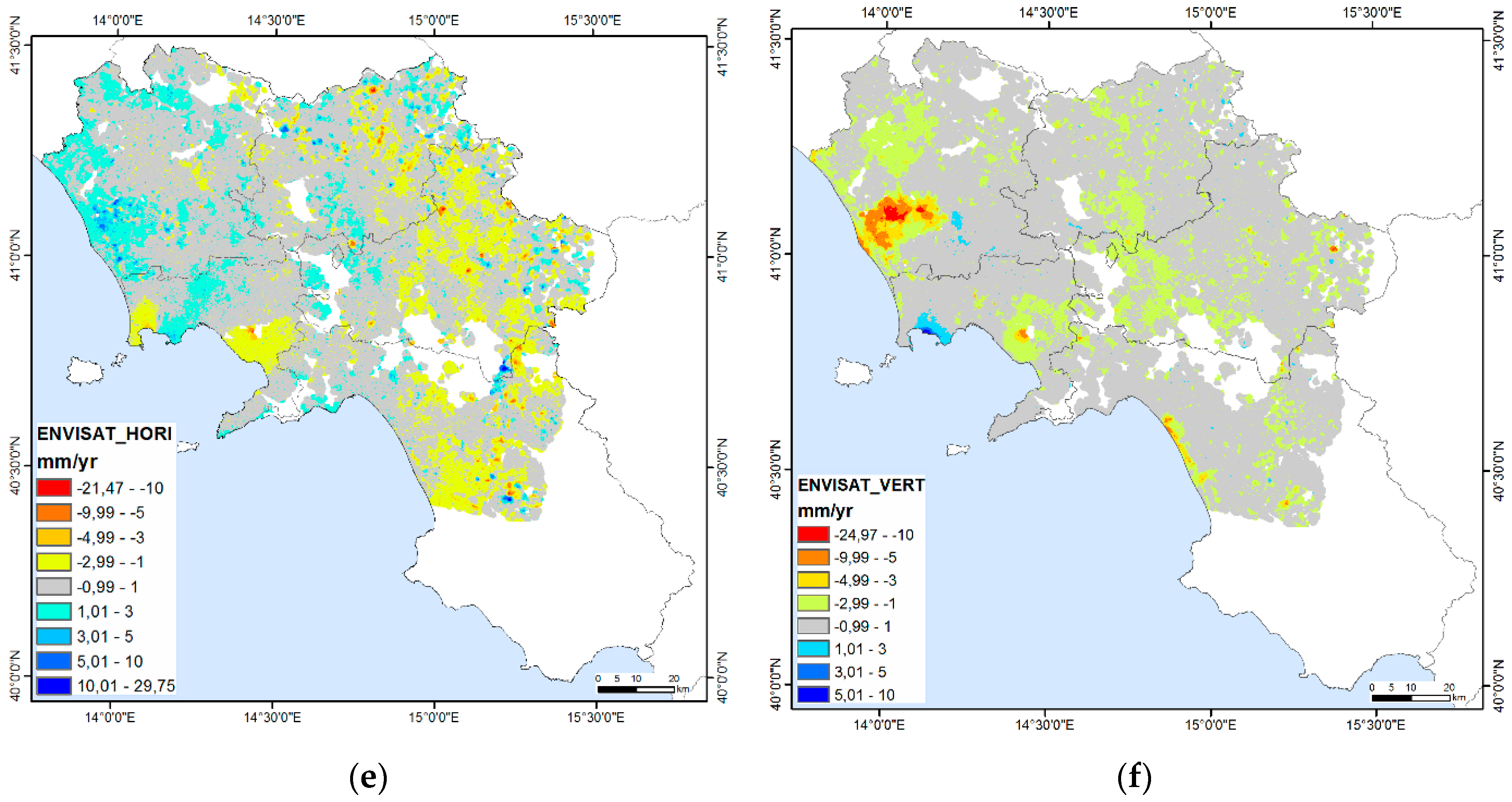
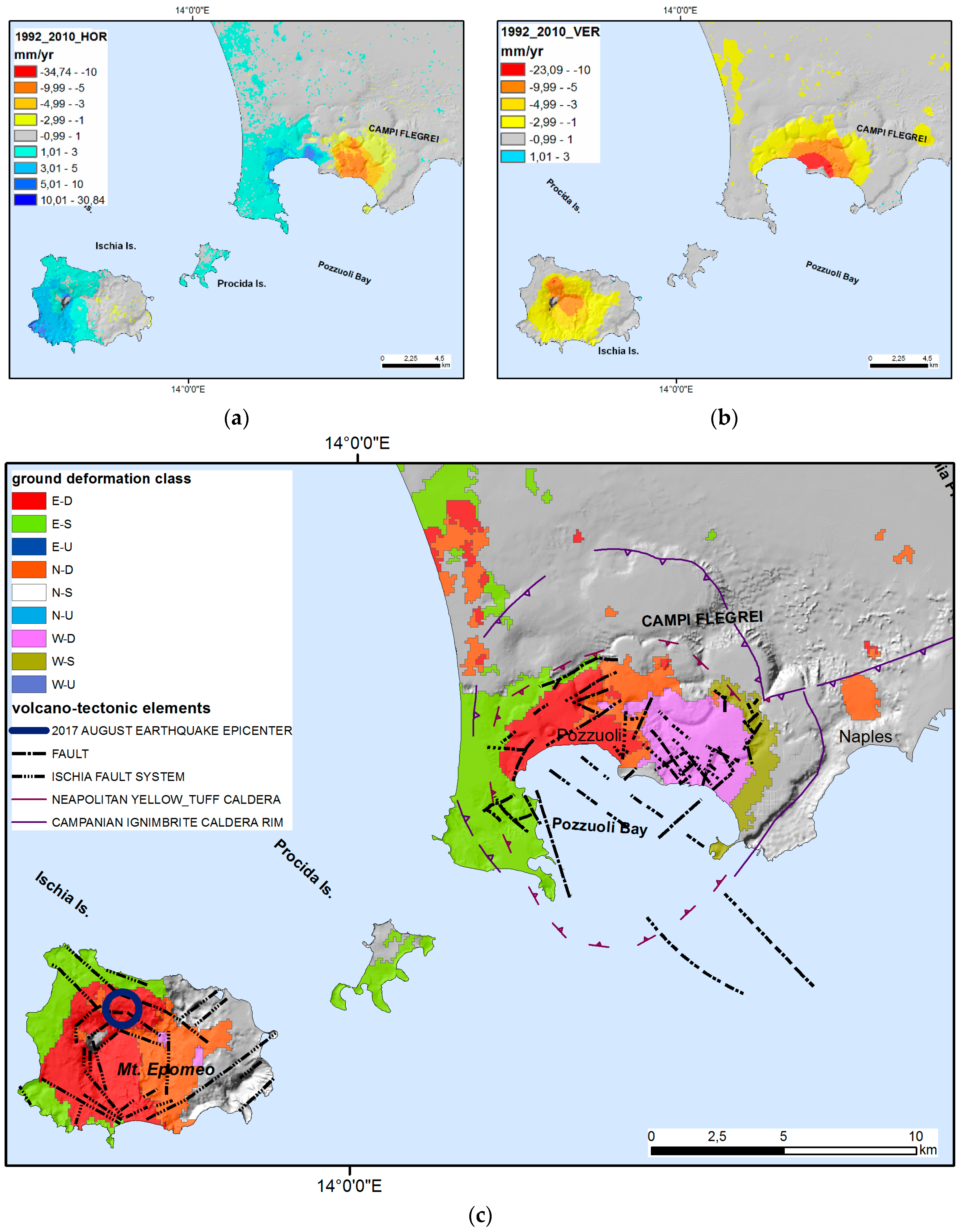
The ground deformation patterns referring to the whole 1992–2010 period (
Figure 11) show that the eastern sector of Campi Flegrei is characterized by westward velocity whereas the western sector is characterized by eastward velocity with maximum values in the caldera central area (around Pozzuoli), where also subsidence increases. This is only a cumulated deformation related to the different contribution experienced during the 1992–2010 period. In fact, at Campi Flegrei, after a strong uplift (about +3.30 m in Pozzuoli city center) occurred during the two 1970–1972 and 1982–1984 bradyseismic crises, a general subsidence (about −1.00 m in city center) between 1985 and 2004 has been followed by still growing uplift phases (about +0.60 m in city center). This assessment is based on levelling and GPS surveys made by INGV-Osservatorio Vesuviano [
38].
Referring to the time interval of SAR acquisition (June 1992–July 2010), the Pozzuoli city center experienced a subsidence of about 30 cm from mid-1992 to late-2004 followed by an uplift of about 10 cm from early 2005 to mid-2010, causing a net subsidence of about 20 cm if referring to the whole period 1992–2010 (see benchmark 25A in [
38]). This ground deformation pattern is representative of the whole caldera area, even if with lower magnitudes in peripheral sectors. The largest ground deformation is localized within and around the structural border of the Campi Flegrei caldera and a systematic recurrence of opposite trends (uplift vs. subsidence) in the ground deformation of the inner caldera region with respect to the surrounding areas has been recognized [
16]. The analysis of PSI velocity and acceleration annual variations also revealed intense yearly dynamics of the Campi Flegrei caldera collapse-resurgence system. This ground deformation field, combined with the re-activation of the caldera ring-faults, intra-caldera faults, and eruptive fissures, indicates a contraction (deflation) of the caldera due to a depressurization of the hydrothermal system and degassing from a magmatic reservoir (in [
14] and references therein). The rates of vertical and horizontal components of ground deformation (
Figure 11) are in full agreement with deformation data based on levelling and GPS surveys made in the last decades [
14,
38].
Ischia Island shows a general vertical subsidence with velocities between −1 and −10 mm/yr, centered in the inner sector of the Mt. Epomeo volcanic complex, coupled with a general eastward horizontal displacement field characterized by a different trend in the eastern sector of the island (higher eastward velocity, from +3 to +25 mm/yr) respect to the central-western one (up to +3 mm/yr), suggesting an overall contraction movement (
Figure 11).
The vertical component velocities are comparable with those obtained by levelling lines (for example −12.7 mm/year at benchmark BM100; [
36]) referred to the same time period [
5]. The E-W striking, south dipping normal fault mechanism of the 21 August 2017 earthquake (Mw 3.9–Md 4.0; Imax EMS 8; hypocenter depth 800 m) that struck the northern sector of Ischia Island is very likely induced by the observed long-term subsidence phase, since the lithostatic load represents the principal vertical stress [
69].
Ischia ground deformation pattern (
Figure 11) cannot be explained by a typical volcanic source [
70,
71]. The Ischia deformation pattern is related to a combination of endogenous and exogenous processes that include deflation of the island related to the depressurization of the local hydrothermal system, fault activity and landslides due to gravity instability on slopes [
5,
35,
36], and to the coupling effects of crust rheology and the gravitational loading of the volcano [
70].
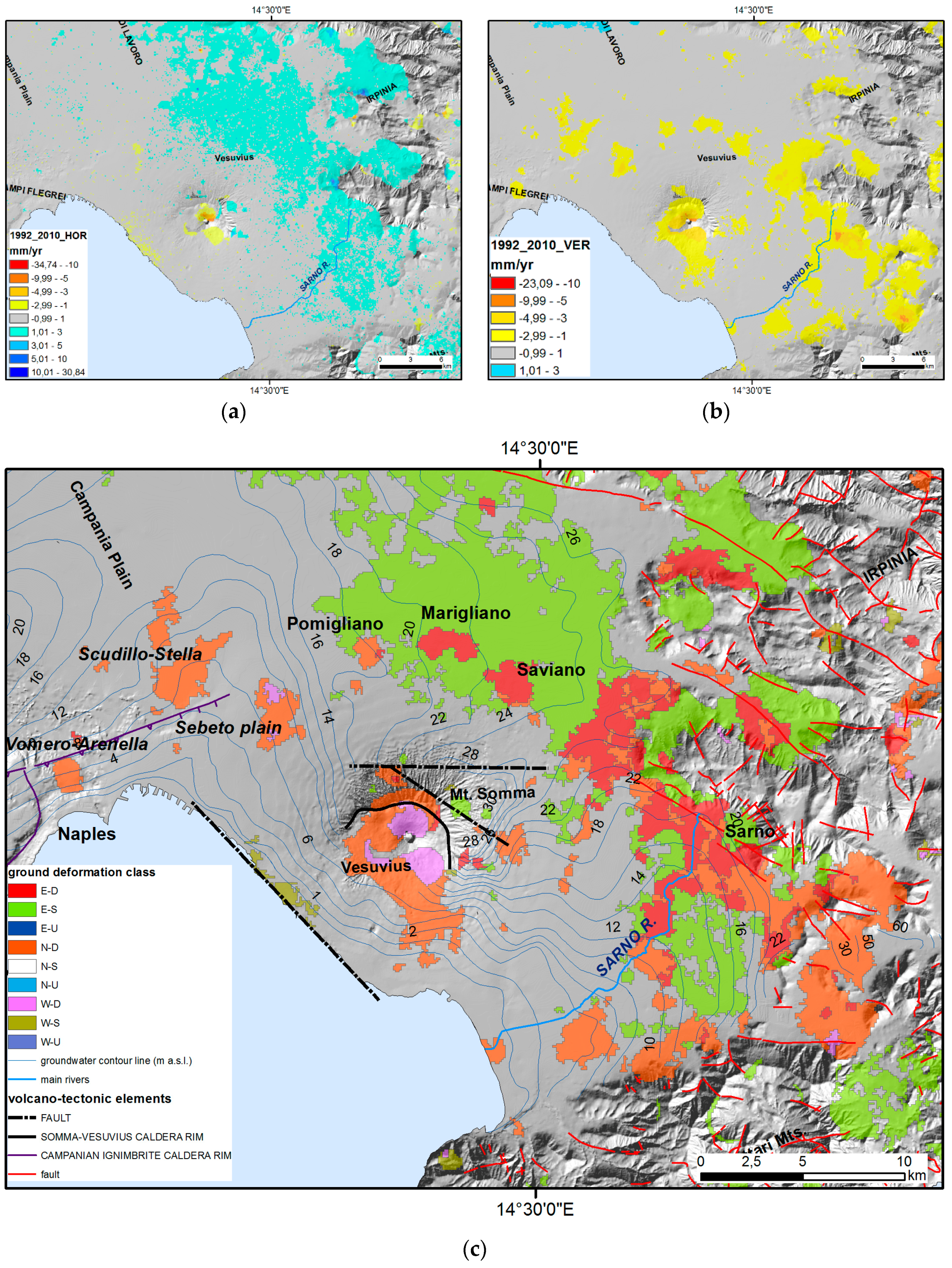
The Somma-Vesuvius is an asymmetric, polygenic volcanic complex formed by the superimposition of two edifices, as the older Mt. Somma with a summit caldera and the younger Vesuvius cone. Its morphostructure results from the combined action of NW–SE faulting and large caldera collapses that occurred in 18 and 79 AD [
72,
73].
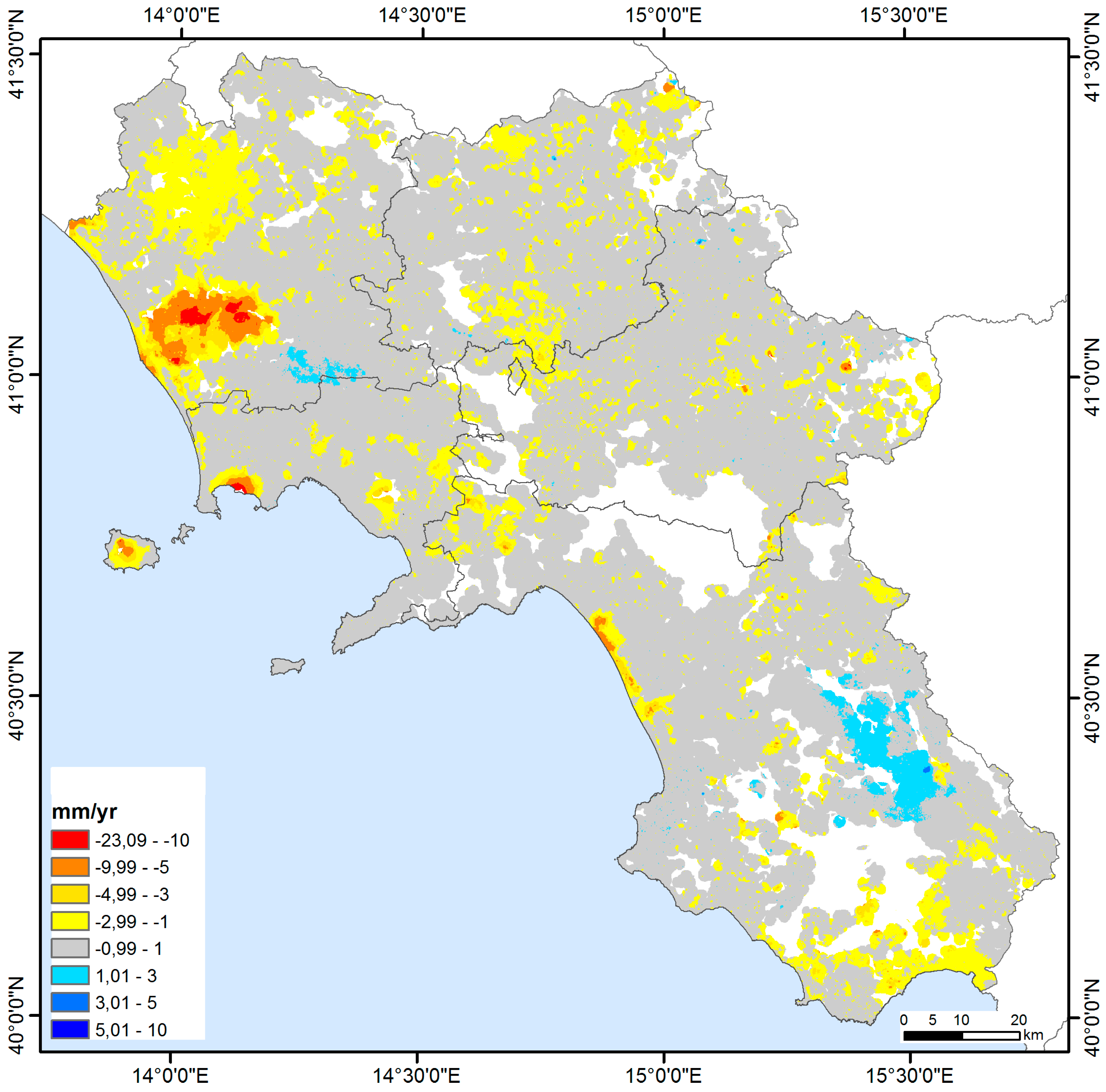
The ground deformation components (
Figure 12) evidence two separated zones of continuous subsidence within the Somma-Vesuvius volcano edifice. The first zone is the Vesuvius central cone and the southern flank, while the second one is represented by a discontinuous strip extending around the volcanic edifice at about 10 km of distance from the crater, where the outer flanks of the volcanic edifice lay on the alluvial-marine sequences of the Campanian plain. The cumulated subsidence rates are mainly comprised between −1 and −10 mm/yr and are confirmed by the available GPS (up to −11.7 mm/yr in 2001–2012 [
74]) and levelling data (up to −15.1 mm/yr in 1973–2009 [
75]) for the flanks and crater. Somma-Vesuvius is affected by a small contraction phase, more marked in the areas with the greatest altitudes, according to the diffuse and modest subsidence observed in the central cone area [
74].
This subsidence pattern is in agreement with the hypothesis that local seismicity, all clustered below the cone itself, is mainly driven by gravitational stress that should produce progressive subsidence of the highest relief zone [
76,
77,
78]. The larger strip of annular, discontinuous subsidence is interpretable in terms of ring-like, shallow normal fault-like movements, occurring at the contact between the volcanic edifice and the rock basement, due to the high gravitational loading coupled with the embedding extensional tectonic stress field. At the main urban centers (Pomigliano D’Arco, Marigliano, and Saviano towns), located in the agricultural and industrial districts north of Somma-Vesuvius, several quasi-circular areas with subsidence rates up to −3 mm/yr can be observed, caused by the effects of water table changes [
49,
78]. In fact, the observed subsidence could reflect a decrease of pore pressure in the soil related to the intense artificial drainage from wells, causing a water deficit in the local water table [
5].
The horizontal deformation (
Figure 12) shows a marked difference between the northern and eastern flanks of Mt. Somma, where reaches values up to +3 mm/yr (eastward movement), and the area encompassing the central cone sector and the southern and western flanks characterized by values up to −5 to −10 mm/yr (westward movement).
The available GPS data (up to 5 mm/yr in 2001–2012 [
74]) confirm this pattern of horizontal deformation velocity. Vilardo et al. [
5] considered the horizontal velocity field consistent with divergent movements between the western and eastern sectors of Vesuvius and Campanian plain due to a NNW–SSE tectonic structure crossing the volcano. Our data suggest that the horizontal pattern is more compatible with a gravitational deformation due to lateral SW- and W-directed collapses of Vesuvius Volcano driven by inherited tectonic faults (i.e., NW-SE normal faults and E-W strike-slip fault) as already hypothesized by Milia et al. [
72].
In the sector located between Vesuvius and Campi Flegrei, our data suggest the presence of scattered ground deformation areas. In the north-eastern Naples urban area (Sebeto plain), a subsidence trend with rates of −1 to −5 mm/yr is present (
Figure 12).
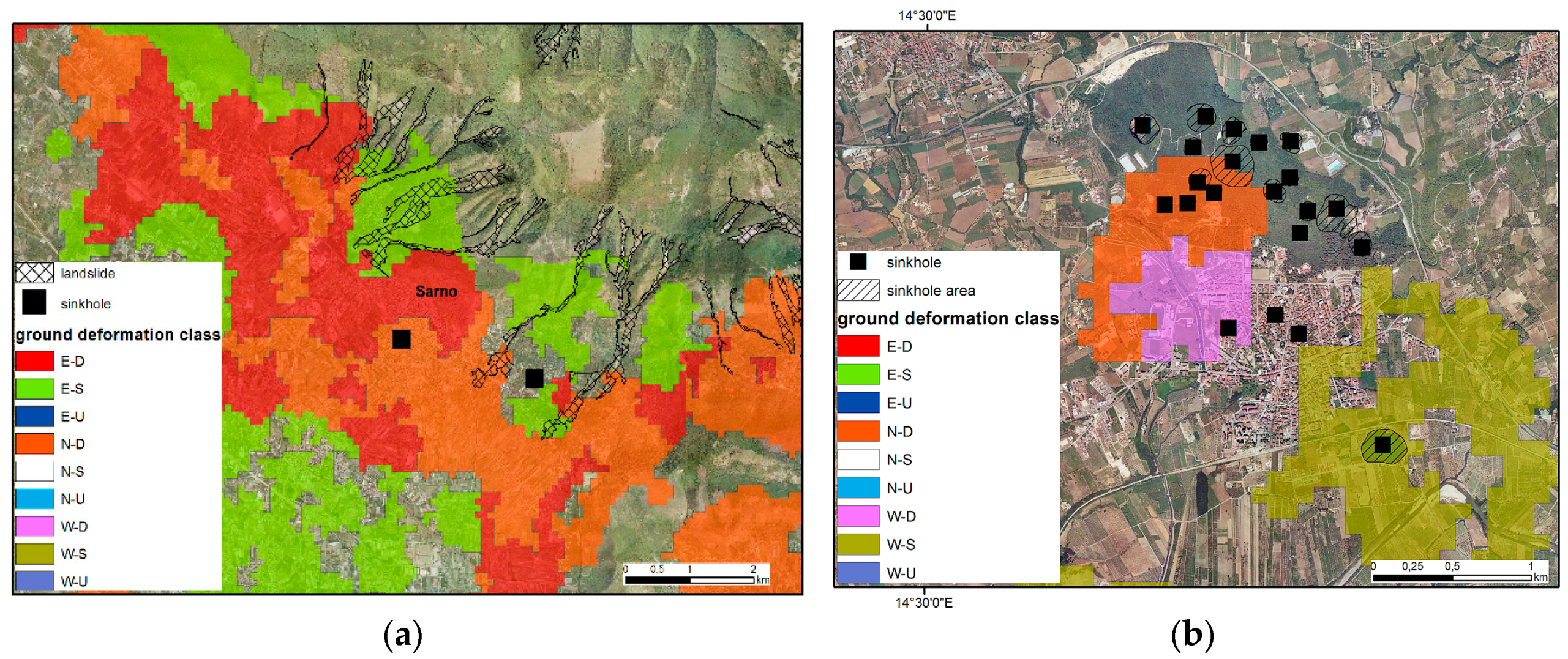
This ground deformation trend can be caused by piezometric level lowering following groundwater pumping in the multi-layered pyroclastic-alluvial aquifer linked to a poro-elastic mechanism in the aquifer system [
68]. Several small areas of subsidence (i.e., Vomero-Arenella and Scudillo-Stella districts) with rates up to −10 mm/yr induced by anthropic and natural processes are affecting residential districts of Naples urban areas.
A multiple association of triggering factors cause these subsidence processes [
13] that are both of anthropic (subsoil excavations for the construction of transport infrastructures, filling/emptying cycles of large underground water reservoirs, rise of the water table due to the stop of ground water withdrawal) and natural (gravity slope instability related to local morphological factors, re-activation of the bradyseism phases in the Campi Flegrei caldera) origins.
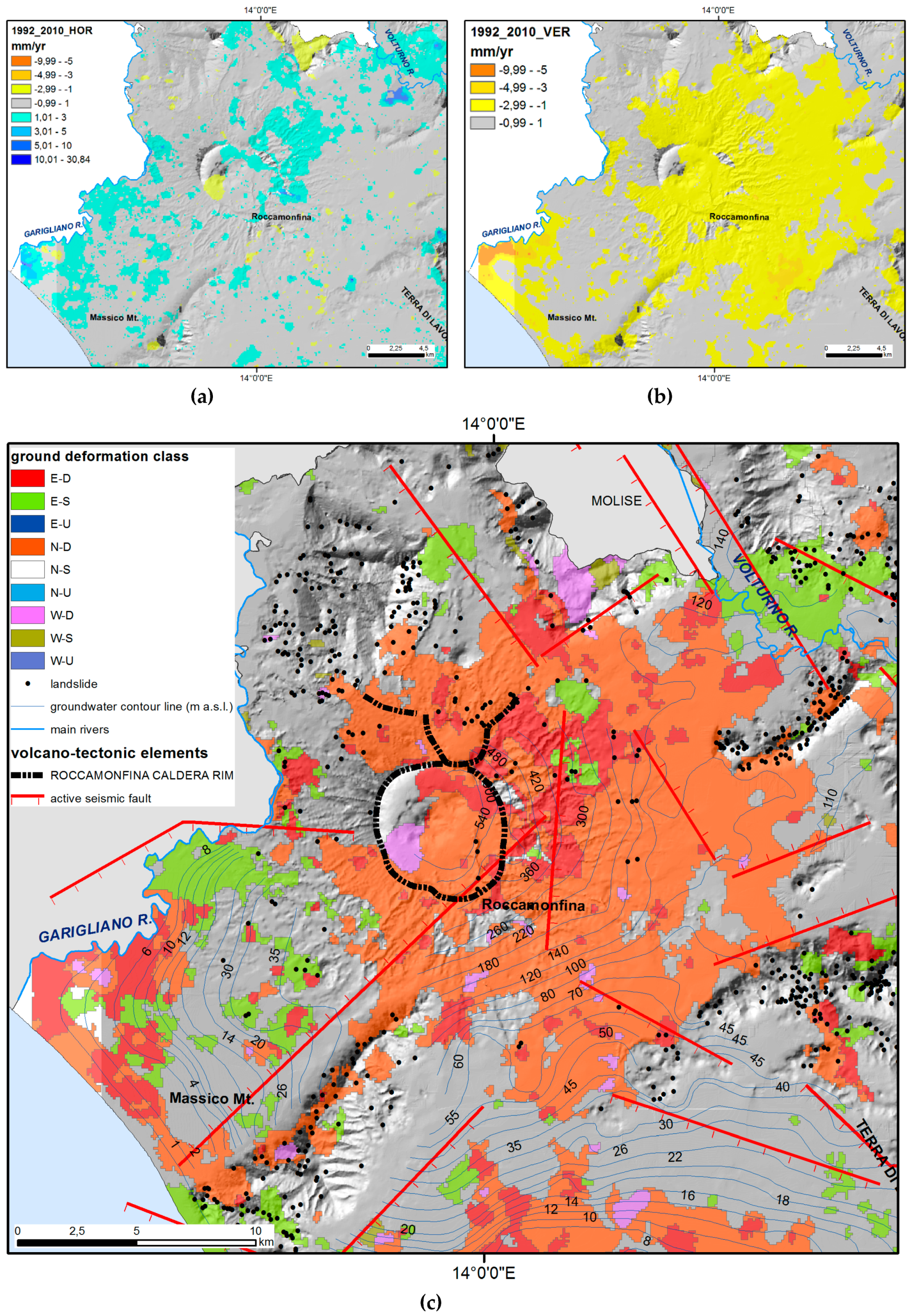
The Roccamonfina volcanic complex is an extinct stratovolcano that was active from 550 to 150 ka in the Garigliano river rift valley. It and was affected by an intense plinian activity revealed by very large craters.
The central caldera is the result of the eruptive explosions at 353 ± 5 ka, while the latest stage of activity featured the edification of the central shoshonitic domes at 150 ka [
79,
80]. The ground deformation components (
Figure 13) evidence a large area of subsidence with vertical rates between −1 and −3 mm/yr centered on the eastern sector of the caldera rim; the E-W horizontal deformation is less relevant and shows discontinuous positive rates on the NE flanks of the volcanic complex and a localized westward deformation within the caldera southern sector (
Figure 13).
Even if no interpretation about the residual volcano-tectonic activity geodynamics of Roccamonfina sector is available in literature, the generalized subsidence could be related to the structures produced by the caldera collapses, while the eastward horizontal movements on the eastern flanks could be also linked to slope instabilities.
5.4. Apennine Sectors
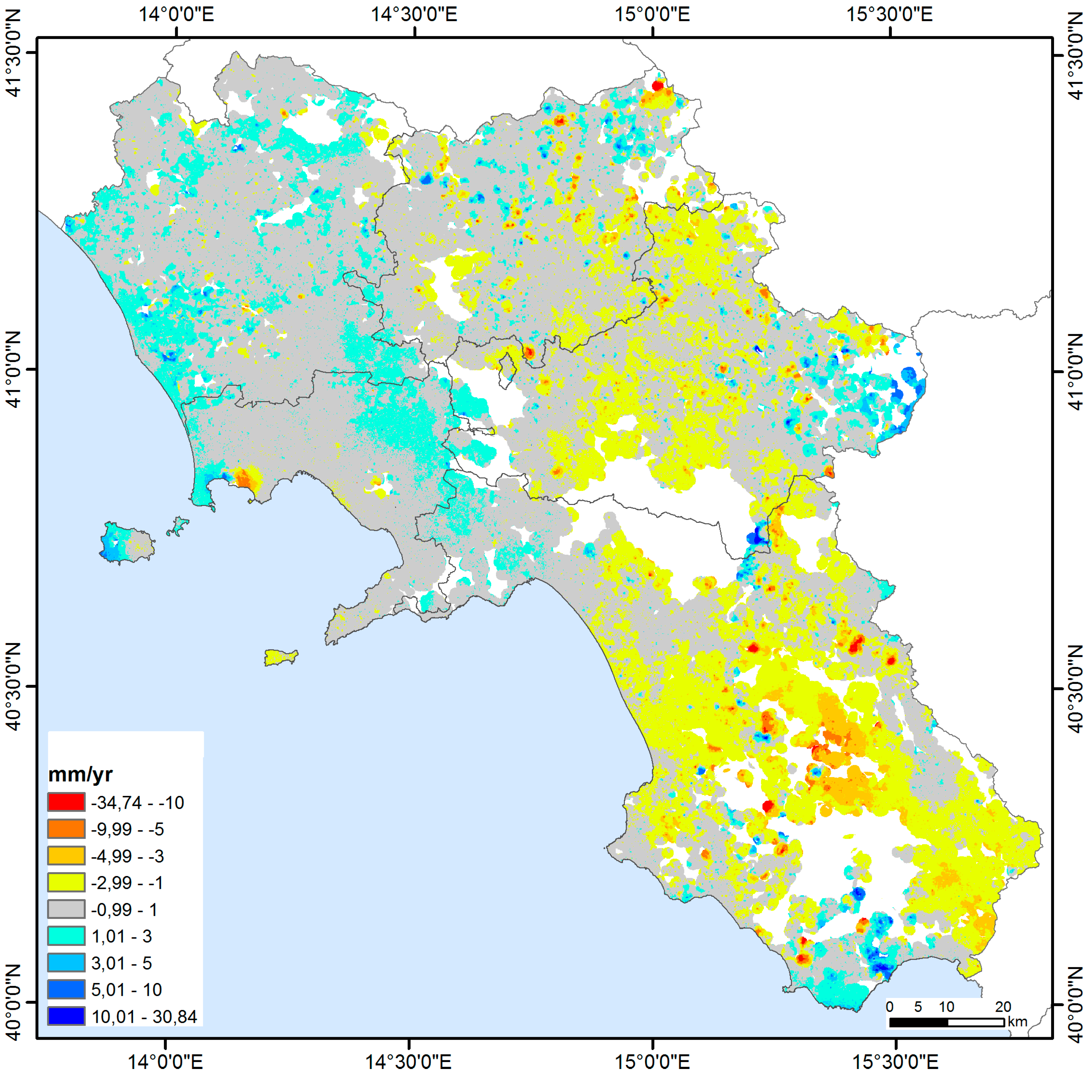
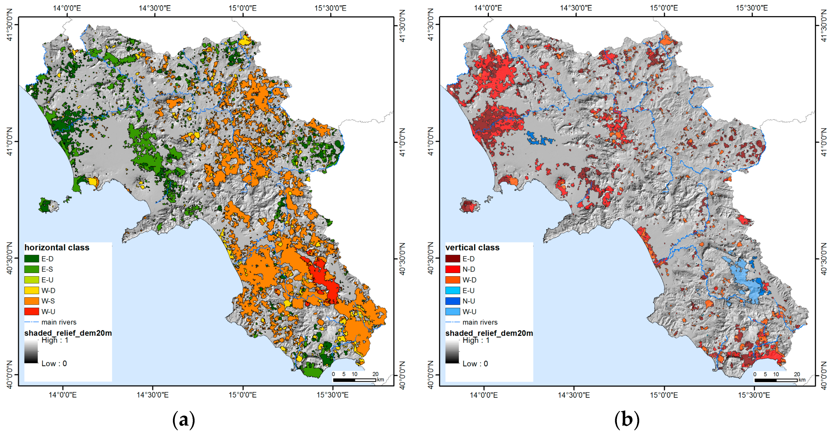
The Southern Apennines sector of the Campania Region appears to be a relatively stable area with reference to vertical deformation (
Figure 8b) with scattered and restricted spots of negative vertical rates within −1 to −5 mm/yr. Only the large sector near Alburni massif shows positive vertical rates. Instead, large hilly and mountainous sectors in Irpinia, Sannio and Cilento are characterized by the westward horizontal component of ground deformation (
Figure 8a).
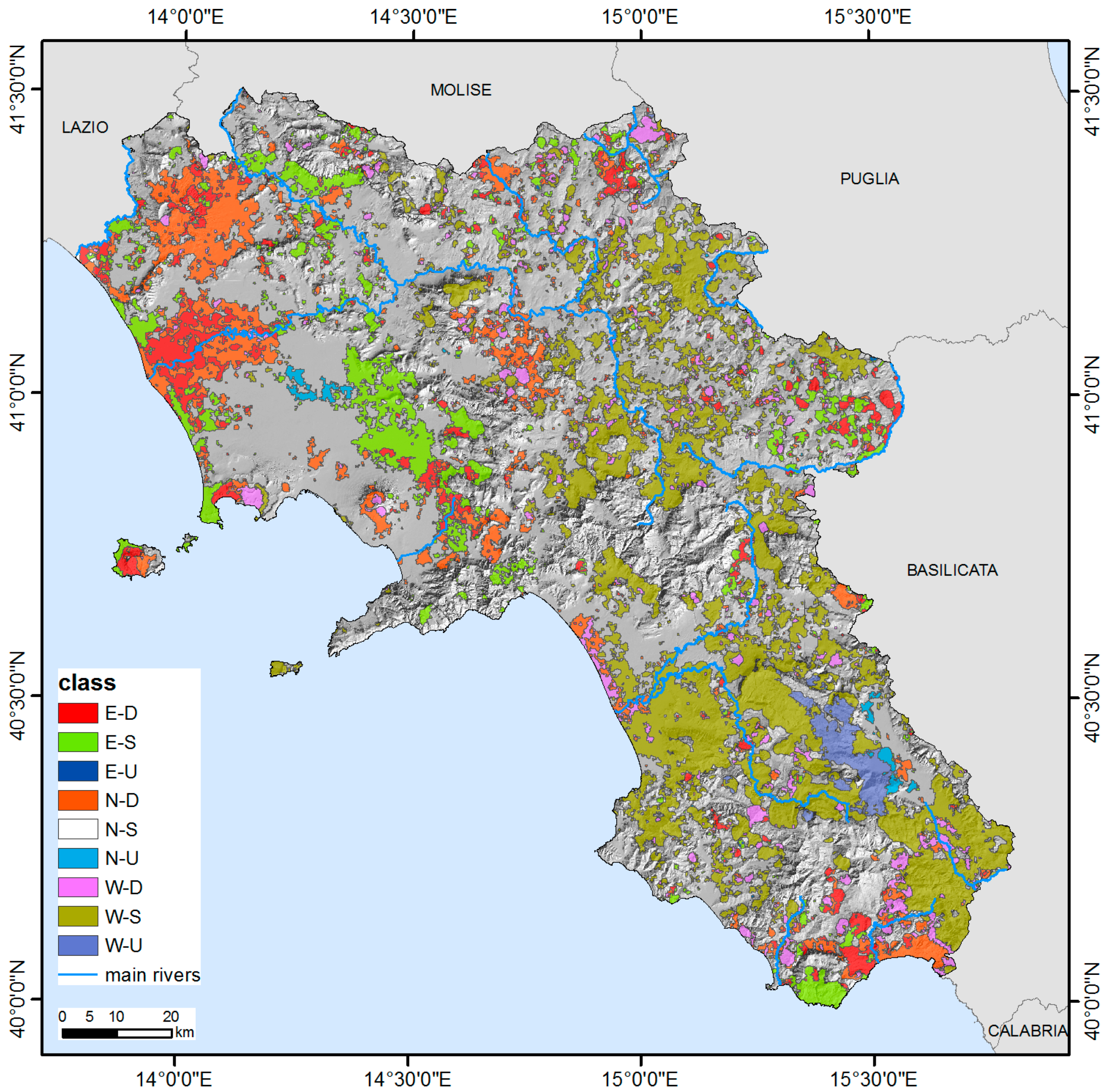
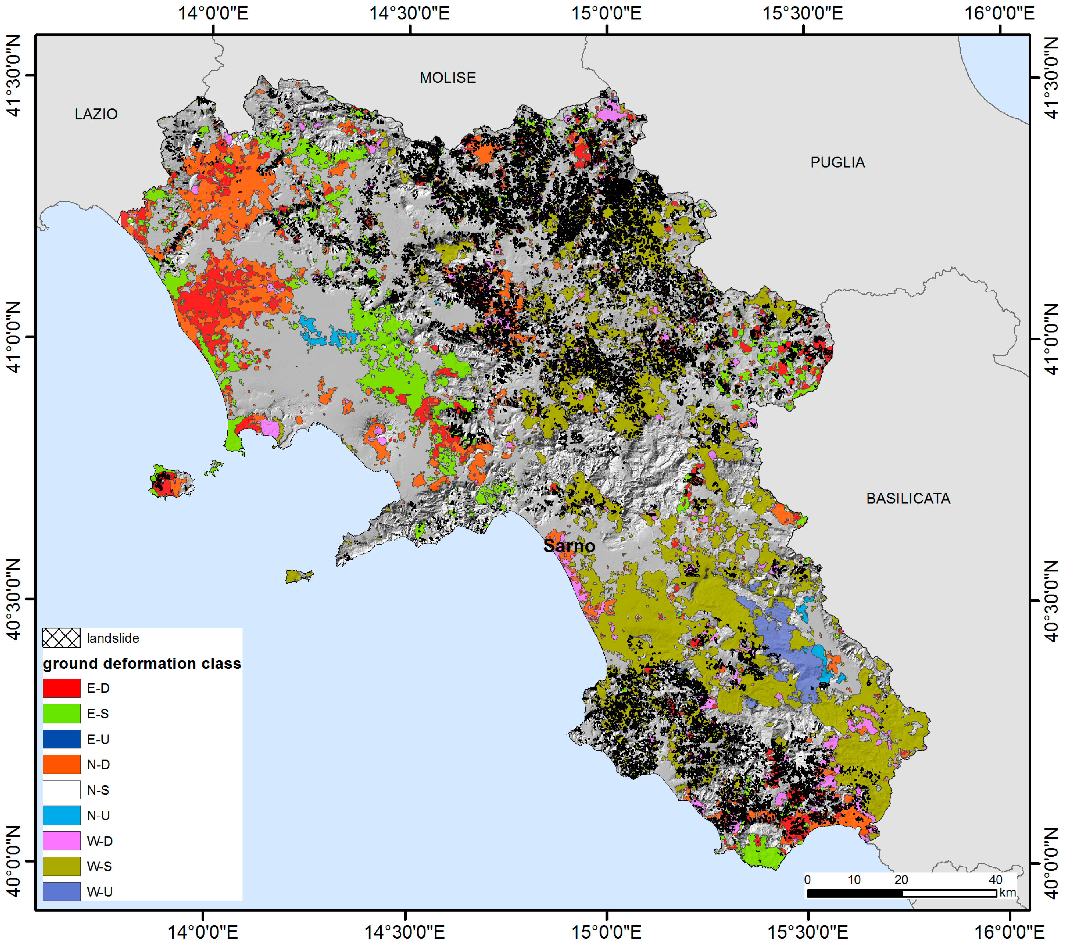
The small scattered subsidence areas are probably related to landslide and sinkhole processes along the hilly and mountainous slopes. Most of the mapped landslides overlap the areas with subsidence and westward horizontal deformation (
Table 7,
Figure 15). Several studies used the PSI data for upgrading landslide maps and inventories in hilly and mountain sectors and defining their state of activity, especially for town-damaging landslides [
12,
21,
84]. PSI data were also used to classify existing landforms susceptible to slow landslides along the Tammaro river valley in the central sector of Sannio area [
85,
86]. The detailed analysis of several case studies about towns affected by landslides in a mountain site, large landslides along fluvial valleys, and Deep Seated Gravitational Slope Deformation (DSGSD), confirm the results obtained in this study also at local scale.
In the following sections, some relevant examples are described (
Figure 16). Castelpagano is a small city located in the high valley of the Fortore river, characterized by severe ground deformation affecting the urban area (
Figure 16a) due to different types of landslide (earthflow, rotational slide, translational slide and complex). The ground deformation components show up to −18 mm/yr (westward) and up to −4 mm/yr (subsidence) indicating a general landslide direction toward SW compatible with the local geomorphological conditions. Field monitoring with GPS surveys and clinometer measurements in boreholes are coherent with the results of this study [
15]. A large landslide affected the town of Calitri, located in eastern Irpinia in the Ofanto river valley, in the 80s to early 90s. The Calitri landslide is a complex slope movement, composed by a large deep-seated slide, reactivated after the 1980 earthquake, and a limited shallow mudslide showing impulsive activity linked with rainfall events [
87]. No significant movements affected the area (
Figure 16b) during the analyzed period (1992–2010), as confirmed by field monitoring activities [
87].
Moio della Civitella is a small town located in southern Cilento on a slope formed by mainly argillaceous-calcareous rocks. The deformation components along the slope (
Figure 16c) are comprised up to −16 mm/yr (westward) and up to −2.5 mm/yr (subsidence) confirming the landslide direction toward SW. The ground deformation effects are related to large slow to very slow landslides, confirmed by GPS surveys, and are coupled with very high levels of damage in masonry old buildings. Actually, the damages are caused by other causes such as thermic effects, bad plans, and inadequate foundations [
12,
21,
88,
89] and enhance those induced by slope movements, resulting in very high values of SAR ground deformation signals. Finally, a DSGSD affects Bisaccia, a small town located in eastern Irpinia in the Cervaro river high valley. The DSGSD involves a brittle lithotype (Pliocene conglomerates) resting over a structurally complex, mainly pelitic unit (“Argille Varicolori”). The deformation components measured in this study are comprised of up +8 mm/yr (eastward) and up to −13 mm/yr (subsidence) confirming the slope deformation kinematism. As a consequence of repeated seismic actions (M 6.7 in 1930, M 6.1 in 1962, M 6.9 in 1980 earthquakes), the top rigid plate made up of lithified conglomeratic layers resulted in being split in five portions, showing different rates of vertical and horizontal displacements (within some cm/yr), causing severe damage to the old village settlement [
90].
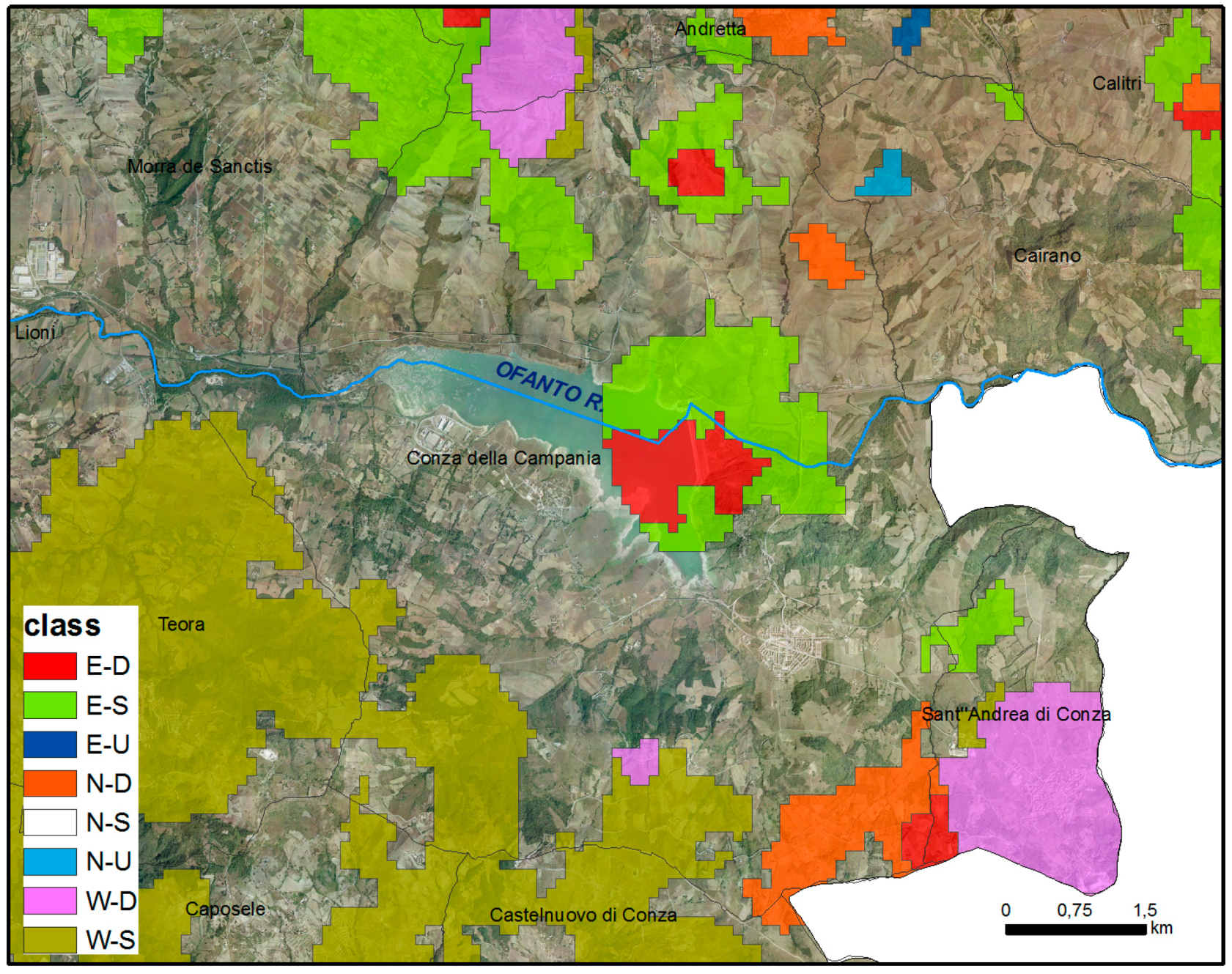
The dams providing lakes forming water reservoirs for agricultural and town needs are another source of ground deformation that is present in the inner sectors. For example, the Conza della Campania earth dam (
Figure 17), located in the Ofanto River valley in Pliocene clay, show relevant deformations. The deformation components measured in this study are comprised of up +4 mm/yr (eastward) and up to −2 mm/yr (subsidence) confirming the earth dam ground deformation pattern obtained by in-situ monitoring conventional instrumental data (levelling, extensometers, etc.) [
91].
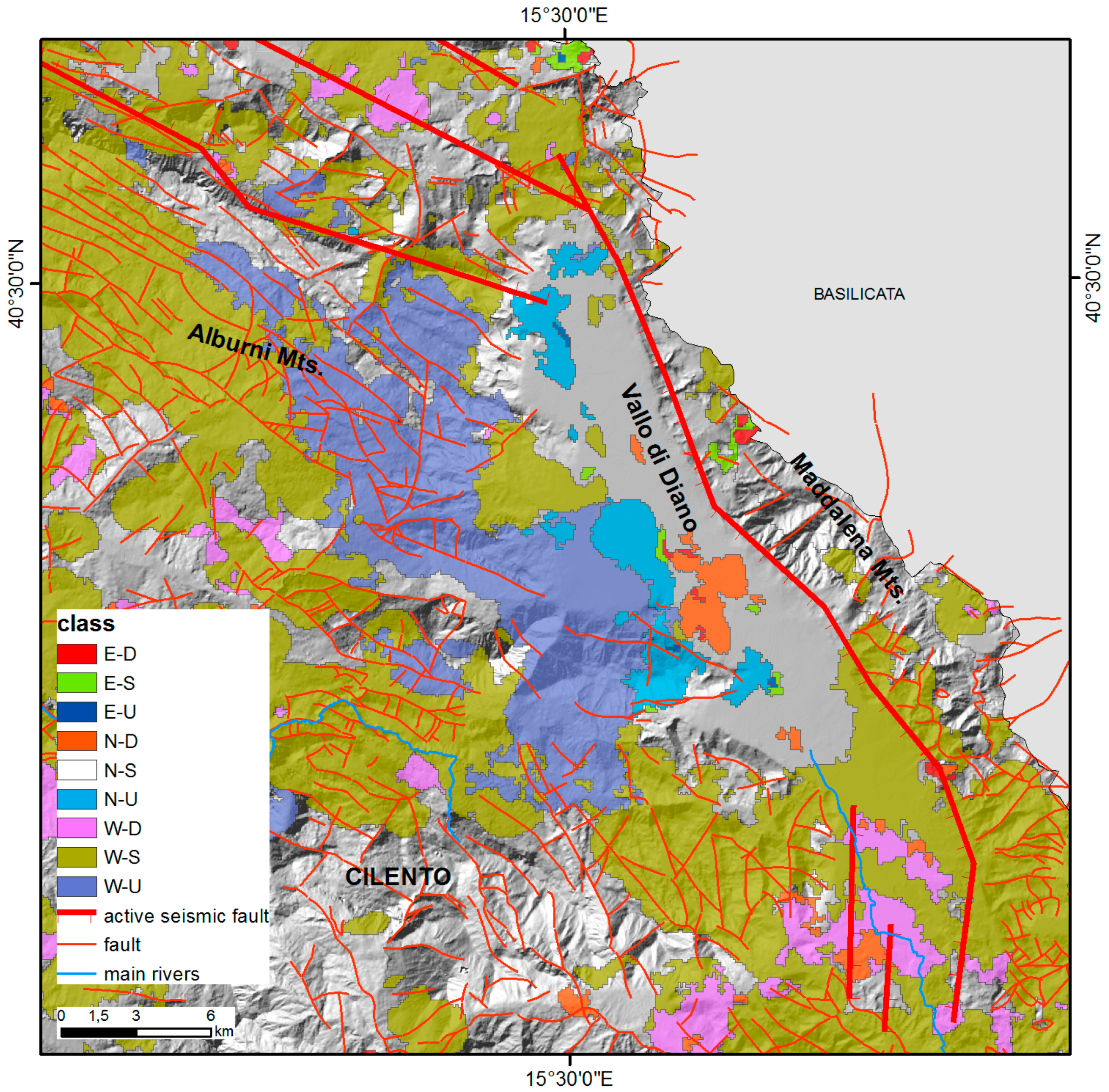
A large sector located south to the Alburni massif (
Figure 18) shows significant positive vertical rates (uplift up to +5 mm/yr) combined with negative horizontal rates (westward horizontal motion up to −10 mm/yr), while the Vallo di Diano valley is characterized by subsidence. The observed ground deformation pattern can be caused by tectonic activity. The Alburni Massif and and Vallo di Diano are crossed by NW–SE striking normal active faults, which could act with a strike-slip component of motion. In fact, the major earthquakes (M > 5) univocally indicate active extension, while the minor seismicity shows a more complex pattern with strike-slip, transtensive and occasional compressional events [
92].
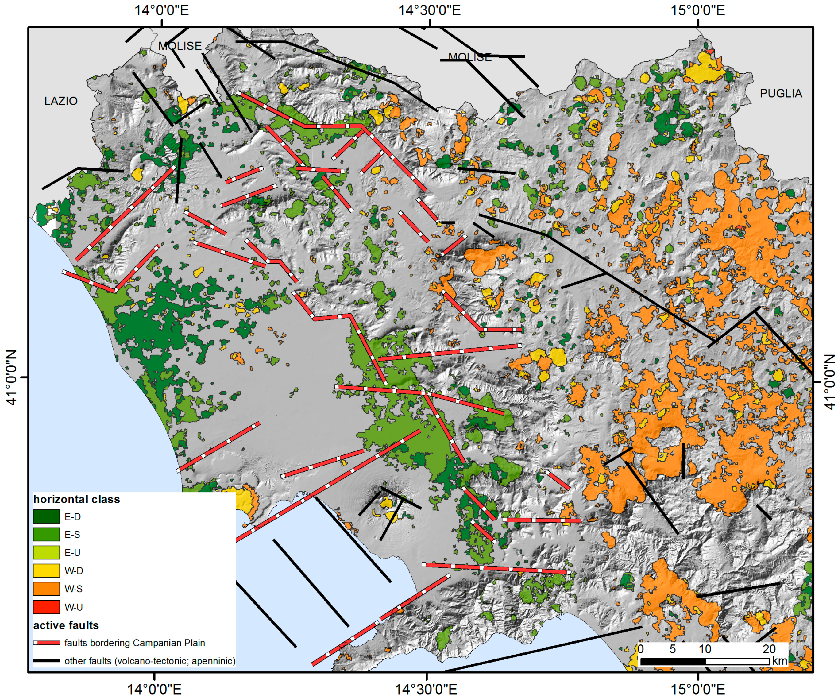
Very large sectors in Irpinia, Sannio, and Cilento are characterized by a prevailing westward horizontal component of ground deformation with rates within −1 to −5 mm/yr (
Figure 7). Smaller areas with eastward velocities of +1 to +3 mm/yr or westward velocities of −5 to −10 mm/yr are also scattered within these sectors, and are likely linked to local movements due to landslides (
Figure 15). In the northern part of Campania, the combined vertical and horizontal velocity patterns at the boundary between the Apennines sectors of Sannio and Irpinia and the Campanian plain clearly show that the western sector is affected by subsidence or null vertical deformation and eastward deformations, whereas the eastern sector is characterized by subsidence and westward movements (
Figure 8). Additionally, in the southern part of Campania (Cilento sector) the ground deformation pattern is mainly characterized by subsidence and westward movements (
Figure 8).
The spatial discontinuity between these two horizontal velocity fields (eastward at the west side and westward at the east and south sides) roughly overlaps the Campanian plain-Apennines morphological boundary (
Figure 19), which is marked by NW–SE to NNW–SSE striking faults, moving with prevailing strike-slip movements, as supported by the available seismic data, which show strike-slip to oblique-slip focal mechanisms for the seismic events [
5].
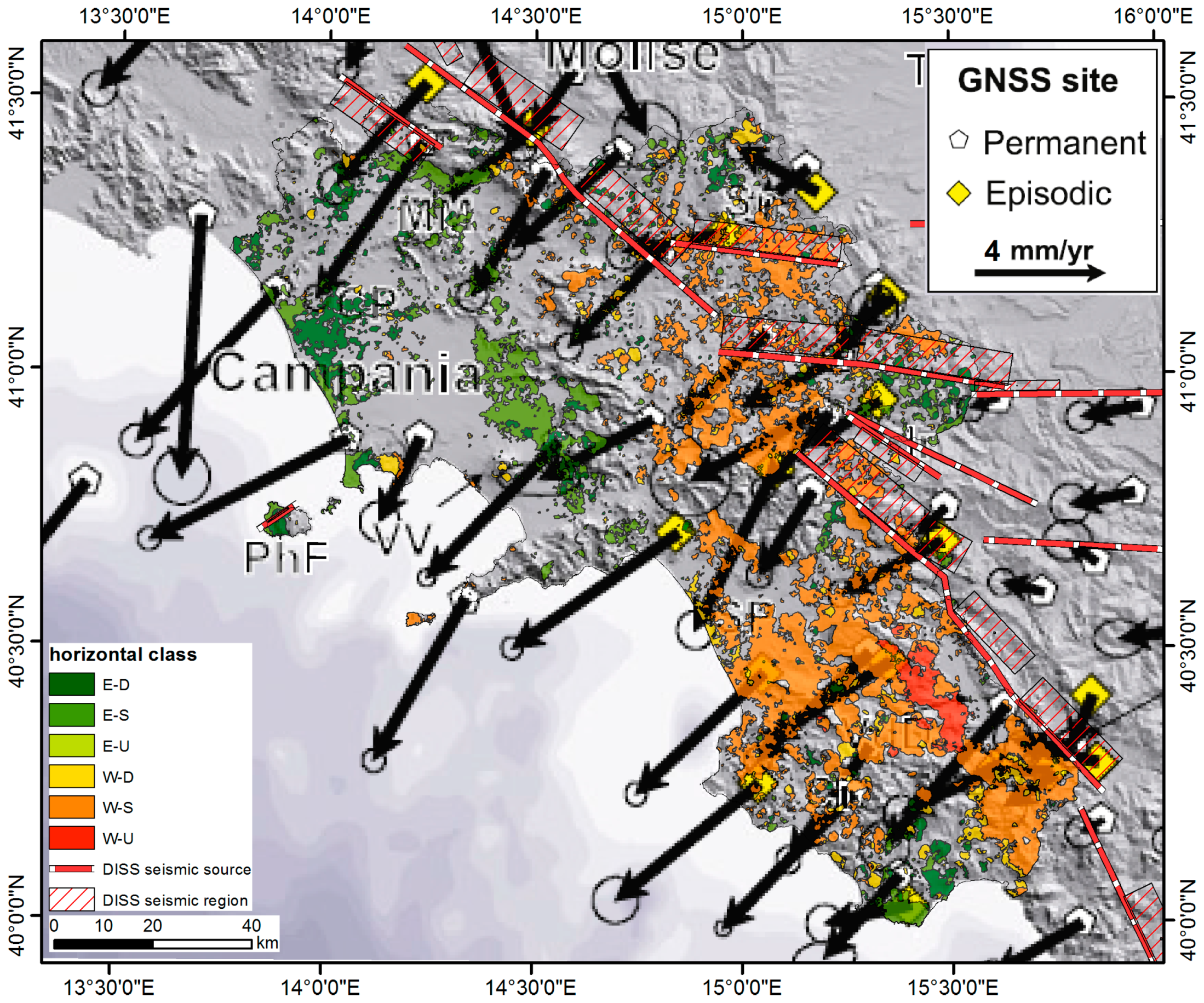
The swarm of active seismogenic normal to strike-slip faults along the axis of the mountain belt along Sannio, Irpinia, and inner Cilento sectors has been associated to most of the large historical earthquakes, which concentrate in the extensional domain. The geodetically-estimated rate of regional extension varies from ~2–3.5 [
37,
93] to ~4–6 mm/yr [
94,
95,
96] and can partly explain the observed ground deformation trends in the easternmost sectors of Sannio and Irpinia (
Figure 20).
The GNNS (Global Navigation Satellite System) values available at regional scale [
97] are in the range of those estimated by PSI in the same areas and show very similar patterns. The velocity field derived from GNNS surveys spanning the 1995–2011 year interval in sites located throughout southern Italy [
97] appears separated in two domains separated along the eastern axis of the mountain chain and characterized by different deformation trends. Velocity patterns evidence on the Tyrrhenian side of Campania region, a W- to SW-oriented motion at a rate of 3 to 6 mm/yr referring to the Apulia frame, while only the easternmost sectors of Sannio and Irpinia have a W-directed motion at a lower rate of 1–2 mm/yr with a differential rates of about 3 mm/yr between the two sectors. Sites located in the Campanian plain show a pattern that differs from the general trend due to local effects deriving from volcanic centers (Vesuvius, Campi Flegrei, Roccamonfina) and local subsiding effects (Volturno plain) on the western Campania margin (
Figure 20).


