Article

Forgotten Nazi Forced Labour Camps: Arbeitslager Riese (Lower Silesia, SE Poland) and the Use of Archival Aerial Photography and Contemporary LiDAR and Ground Truth Data to Identify and Delineate Camp Areas

1
Head Office of Geodesy and Cartography, 2 Wspólna str., 00-926 Warsaw, Poland
2
Faculty of Geodesy and Cartography, Warsaw University of Technology, 1 Sq. Politechniki, 00-661 Warsaw, Poland
3
Foundation Thesaurus, 18 Warpnowska str., 60-453 Poznań, Poland
4
Central Administration, Warsaw University of Technology, 18/20 Noakowski str. 18/20, 00-668 Warsaw, Poland
*
Author to whom correspondence should be addressed.
Remote Sens. 2020, 12(11), 1802; https://0-doi-org.brum.beds.ac.uk/10.3390/rs12111802
Submission received: 30 April 2020 / Revised: 25 May 2020 / Accepted: 26 May 2020 / Published: 3 June 2020

Abstract

:
The “Riese” project was a huge construction project initiated by German Nazi authorities, which was located in the northeast of the Sowie Mountains (Ger. Eulengebirge) in southwestern Poland. Construction of the “Riese” complex took place in 1943–1945 but was left unfinished. Due to the lack of reliable sources, the exact intended function of the Riese complex is still unknown. The construction was carried out by prisoners, mostly Jews, from the main nearby concentration camps, KL Gross-Rosen and KL Auschwitz-Birkenau. Thanks to the discovery in the National Archives (NARA, USA) of a valuable series of German aerial photographs taken in February 1945, insight into the location of labour camps was obtained. These photographs, combined with LiDAR data from the Head Office of Geodesy and Cartography (Warsaw, Poland), allowed for the effective identification and field inspection of the camps’ remains. The location and delimitation of the selected labour camps were confirmed by an analysis of the 1945 aerial photograph combined with LiDAR data. These results were supported by field inspection as well as archival testimonies of witnesses. The field inspection of the construction remains indicated intentionally faulty construction works, which deliberately reduced the durability of the buildings and made them easy to demolish. The authors believe that it is urgent to continue the research and share the results with both the scientific community and the local community. The authors also want to emphasize that this less-known aspect of Holocaust history is gradually disappearing in social and institutional memory and is losing to the commercial mythologization of the Riese object.

Graphical Abstract

1. Introduction

German Nazi concentration camps were a place of death and suffering for thousands of innocent victims of World War II. The significance of commemorating these facilities is emphasized by the fact that, for example, Auschwitz-Birkenau Concentration Camp is on the UNESCO World Heritage Site list [1]. It has been 75 years since the end of the War. New diagnostic techniques are being employed with increased frequency and archives have been made more accessible. Both of these facts have contributed to turning a new page when it comes to researching the history of concentration, labour, penal and death camps from World War II [2,3,4]. It has to be emphasized that the collective memory related to some of those camps is fading away [5], especially if they were never entered into a commemoration framework (such is very often the case with smaller subcamps or camp branches). A lack of legal regulations together with convoluted issues related to ownership of the land only serve to exacerbate the difficulties encountered while trying to commemorate those facilities.
In the last few years, many research papers have been written on the topic of investigating the camps from the time of World War II [5,6,7,8,9]. This is due to the increasing number of interdisciplinary research teams that are being established, and to the explosive growth of digital technologies [10,11]. It is no wonder, however, that many camps have become forgotten over time. Such is currently the case in southwestern Poland, where smaller auxiliary camps created in World War II that operated within the structure of the Gross-Rosen Concentration Camp are now disappearing from the mental map. This paper is the first attempt to locate the five auxiliary camps that together formed Arbeitslager Riese (AL Riese) and to evaluate the level of their preservation using multisource spatial data and witness testimonies. Some of the analysed areas are difficult to reach as they are located in a mountainous region and have since been reclaimed by nature [12]. In other cases, the areas are not available anymore as they were sold and are now private property. Only a handful of such facilities are even marked with a commemorative plaque. Very often, the local government authorities find it difficult to mark such places in their spatial development plans. This type of problem is not unique to Poland, however [13,14].
The following article also explores the concept of taboo heritage as a way to describe a legacy of war so sensitive that the process of heritage creation has never properly begun. There are a number of threats to cultural heritage sites [15]. They can be damaged by natural disasters [16,17,18] and human activity [19], but the passage of time, the conscious or unconscious repudiation of history and memory, and the obstruction of historical or archaeological activities by the local government all play an important role. It is important to initiate a complex academic analysis of those areas because of a currently ongoing investigation by the Institute of National Remembrance of the war crimes committed in the Gross-Rosen concentration camp and its auxiliary camps (including Arbeitslager Riese). Moreover, we should attempt to commemorate and mark those places of memory in an appropriate way [20].

2. Historical Background

The Riese (the German word for “giant”) project was a construction enterprise of Nazi Germany, located in the Owl Mountains (Góry Sowie) range. The construction of the “Giant” took place between 1943 and 1945, but it was never finished [21]. Today we are not even certain of the exact function that the Riese complex was supposed to have. Some existing documents and testimonies point toward the interpretation that the Owl Mountains and the Książ castle (Schloss Fürstenstein in German) were supposed to become the Führerhauptquartiere “Riese/Rüdiger”, meaning they were supposed to be the central headquarters of Adolf Hitler himself, in addition to housing the central headquarters of various elements of the German Army (Wehrmacht) [22]. Some other interpretations lead us to believe that the “Giant” was supposed to be an air-raid shelter for war purposes. Many different factories engaged in the war effort were relocated to the complex, most of them producing equipment for the Luftwaffe (German Air Force). It is also likely that V1 and V2 rocket production took place there [23]. Moreover, there are rumours that Germans brought to the Riese many of the items that they looted. The area of the Sudeten was fairly safe for Germans, so the complex was considered to be secure from Allied air strikes. The plan envisioned the creation of six facilities in the Owl Mountains area, each of them consisting of an aboveground and an underground part, together with all the necessary infrastructure [24]. The Germans constructed many buildings from steel-reinforced concrete and nested them into the slopes of the mountains. Some of them were of a technical nature, some were offices, and others were living quarters. The slopes of the mountains were mined and tunnels were dug that led to the main excavation chambers. It was in those chambers, after they had been made impenetrable by steel-reinforced concrete, that even more office and living spaces were supposed to be located. The construction was carried out by slave laborers coming from the “Konzentrationslager Gross-Rosen” concentration camp [25]. Moreover, the “Giant” was also the location of an auxiliary camp called “Arbeitslager Riese.” According to German documentation, up to 30,000 prisoners participated in the construction of the camp, but confirmed numbers point to only 12,000 or so inmates being present. The sheer size of the construction enterprise, as well as the geographic spaciousness of the area it was located in, made it a necessity to create not one, but a whole network of around a dozen or so smaller camps, called Außenlager in German. Their names were taken from the German names of nearby villages or other geographic features: Wolfsberg, Lärche, Kaltwaser, Eule, Falkenberg, Dörnhau, Wüstewaltersdorf, Wüstegiersdorf (the main camp and command office), Ober Wüstegiersdorf, Wüstegiersdorf Bahnhof, Erlenbusch, Schötterwerk, Tannhausen, Fürstenstein, Märzbachtal, Hausdorf, and Säuferwasser [26]. These camps together constituted AL Riese. However, multiple POW camps and forced labour camps were also located in the same region. They never had a name or number assigned to them, and were acting on an ad hoc basis. Throughout the course of Communist rule in Poland (1945–1990), evidence of this particular crime faded away. The barracks were stripped for parts, the construction materials and machines were moved away, and the prisoners were scattered around the globe. No one has ever investigated the atrocities that took place in the Riese complex in a comprehensive manner. The Main Committee for the Investigation of Nazi War Crimes in Poland did, in fact, conduct investigations in the 1960s and 1970s, but no conclusions were reached and the entire issue remained unclear [27]. Separate investigations were also conducted in the 1960s–1980s by the Central Office of the State Justice Administrations for the Investigation of National Socialist Crimes located in Ludwigsburg in Germany (Zentrale Stelle der Landesjustizverwaltungen zur Aufklärung nationalsozialistischer Verbrechen), but it was not able to produce any meaningful results either. This reminds us of contemporary situations where local authorities of the British Channel Islands of Jersey and Alderney [15] or those living near Berlin [14] have expressed a lack of interest in any archaeological investigations being carried out in their area.
Additionally, between the 1980s and 1990s, the Walim and Głuszyca municipalities sold some of the plots that constituted AL Riese. Between 2015 and 2019, the authorities granted permission to construct buildings on the plots, and that process is currently ongoing. That is why establishing the exact borders of the camps, their thorough analysis, and proper commemoration are so important.

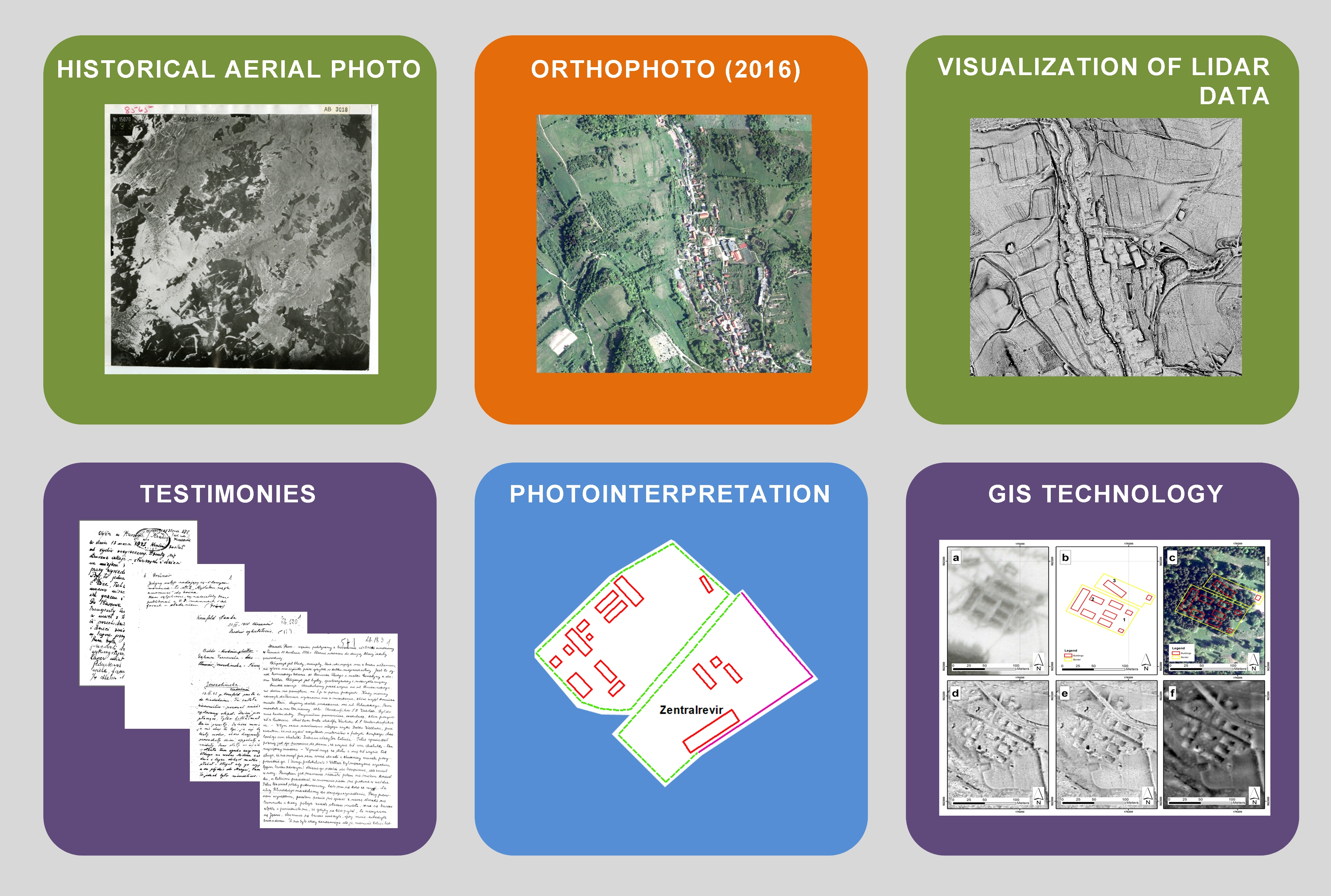
3. Materials and Methods
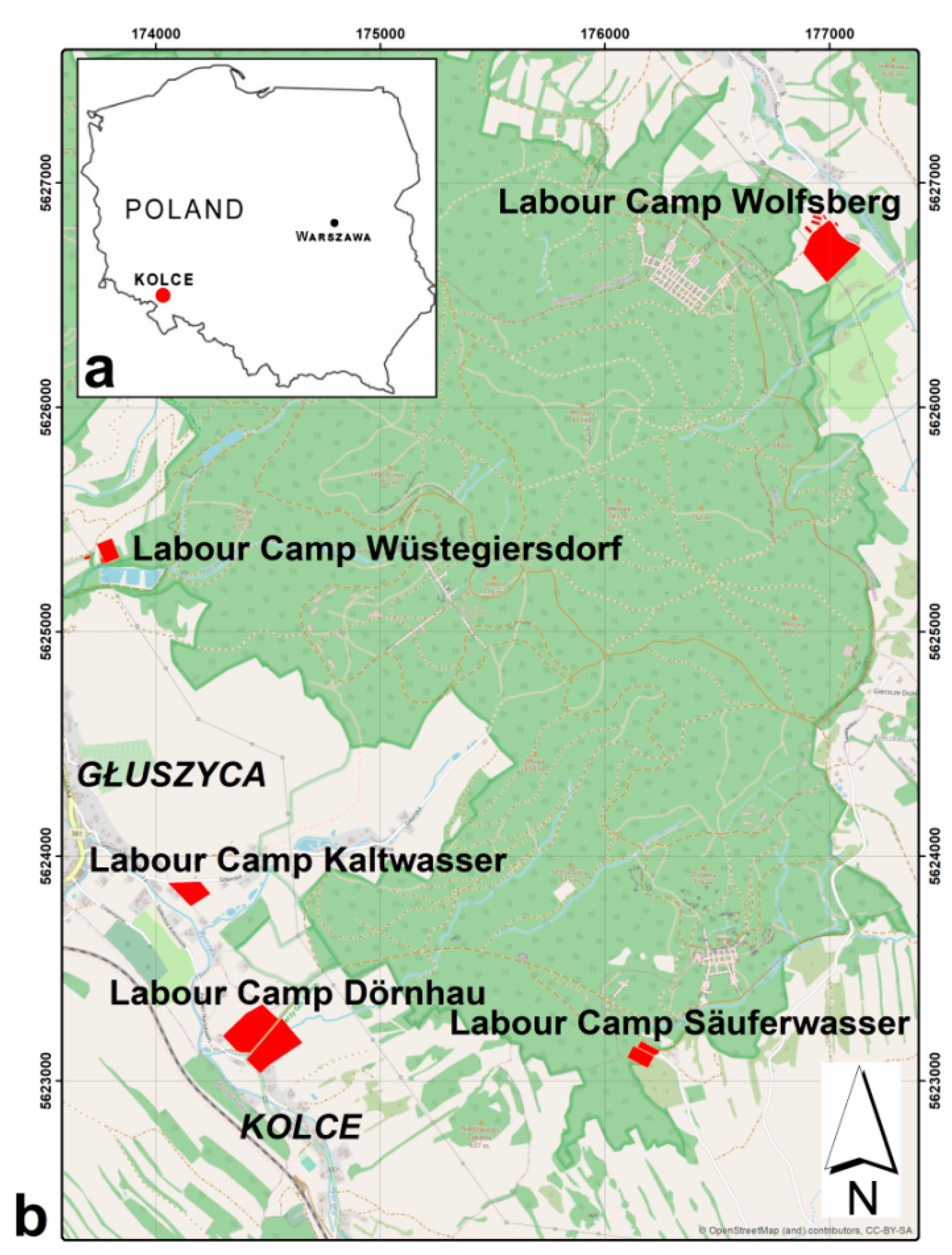
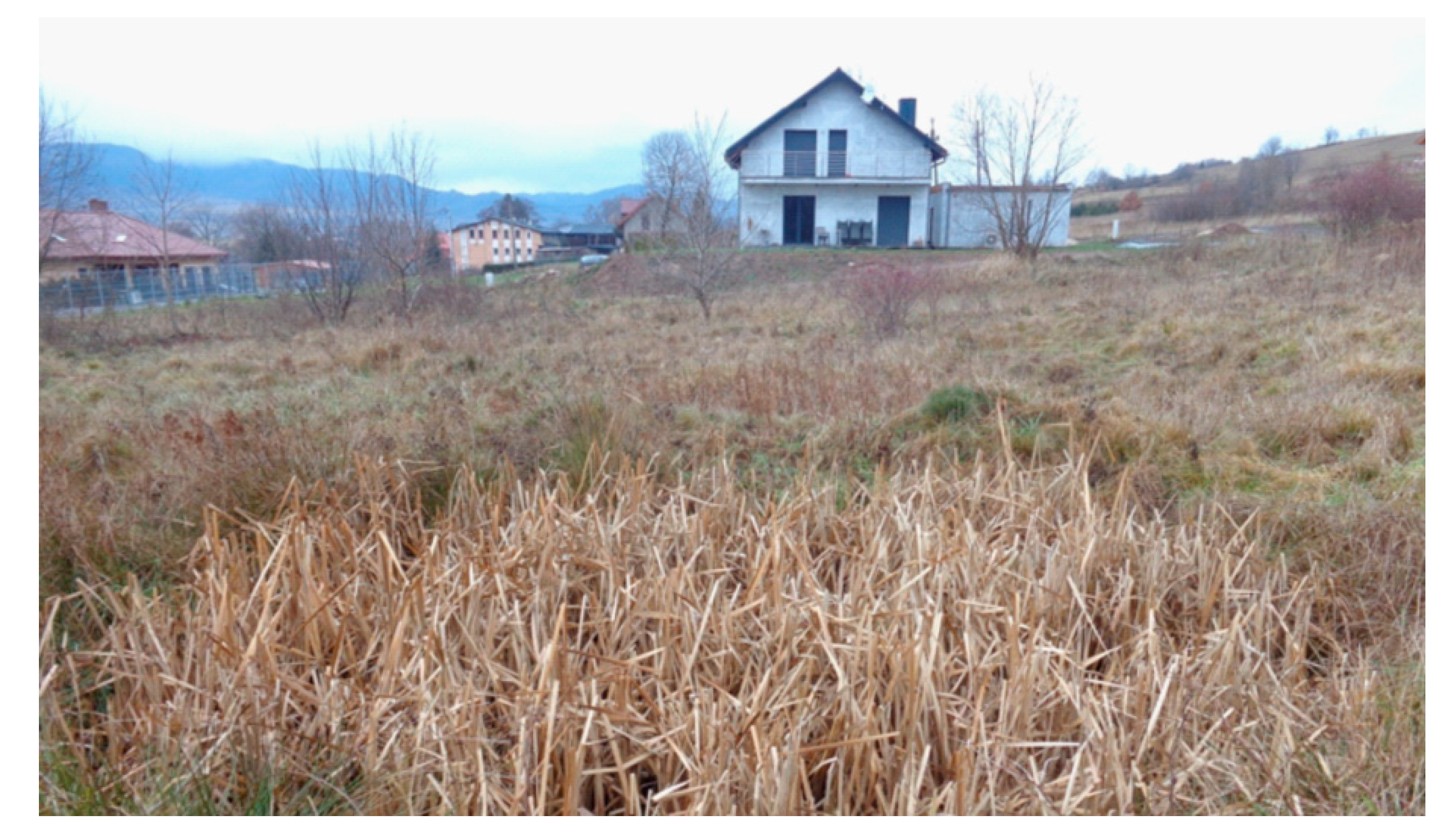
3.1. Study Area

The area in question is situated in Central Sudetes (Figure 1), which constitutes the northern part of the Bohemian massif. The area is on the border between two physiographical units, the Nowa Ruda Depression and the Owl Mountains (Góry Sowie in Polish or Eulengebirge in German). The mountainous part is called the Włodarz massif and consists of five peaks: Włodarz (Ger. Wolfsberg), Soboń (Ger. Ramenberg), Moszna (Ger. Mulenberg), Osówka (Ger. Säuferhöhen), and Ostra (Ger. Spitzenberg). This massif, as well as other parts of the Owl Mountains, is mainly composed of migmatites and gneisses of Cadomian origin [28]. The area to be investigated encompasses four Gross-Rosen auxiliary camps and auxiliary camp where forced laborers working for the local Friedrich Krupp AG branch were held. The exact borders and locations of the chosen spots have not been established with complete certainty until now. Immediate identification and confirmation are required.

3.1.1. The Wolfsberg Labour Camp

The Wolfsberg Labour Camp was established in May 1944 on the northeastern slopes of Mt. Włodarz (Ger. Wolfsberg). It was a big camp that at various points housed 3000–6000 people whose labour was used to construct adits and surface-located facilities in the same area where the camp was located [29]. The network of underground tunnels and the location of objects on the surface is reminiscent of the facility codenamed “Lachs”, which was in the Mt. Walpersberg massif, close to Kahla in Thuringia [30]. This fact alone could provide a hint of the real purpose of the facility.

3.1.2. The Kaltwasser Labour Camp

The Kaltwasser Labour Camp was established at the end of August 1944. The prisoners were mainly Polish Jews who came from the city of Łódź [31]. Eyewitness accounts allow us to document the exact number of people transported to the camp:
The Kaltwasser camp was a camp where 2000 Jews from Auschwitz came to work”.
[32]
The prisoners’ work consisted of tree felling, building roads and narrow-gauge railroads, and digging trenches for the teletechnical infrastructure. It is also possible that the prisoners were responsible for drilling the drifts in Soboń. The camp was closed in December 1944 due to the increasing proximity to the Eastern front.

3.1.3. The Dörnhau Labour Camp

The Dörnhau Labour camp was established in June 1944. The prisoners were Jews of different nationalities. Between June and July 1944, around 250 people were transported to the camp. They were housed in a single two-storey building and their work also consisted of tree felling, building roads and narrow-gauge railroads, and digging trenches for the teletechnical infrastructure in the Długa Góra area. Moreover, they were responsible for the construction of the railway siding in Kolce, which was also part of the Führerhauptquartiere “Riese/Rüdiger”:
Prisoners from nearby camps were all put together in Dörnhau, to work constructing railroads. They were located in a separate camp”.
[33]
It is also believed that those prisoners were responsible for drift construction in the southern part of Riese, in Säufer Höhen (Osówka). The Dörnhau camp was liberated on 8 May 1945 and was into a hospital for its former prisoners [29].

3.1.4. The Säuferwasser Labour Camp

The Säuferwasser Labour Camp began operation between May and June of 1944. The prisoners’ main task was to lay the foundation for various buildings. Some outstanding constructions included the “mess” and the “power plant.” The inmates also participated in the digging of tunnels in Osówka, tree felling, building roads and narrow-gauge railroads, digging trenches for the teletechnical infrastructure, and constructing various buildings. The camp was liberated in May of 1945 [29].

3.1.5. The Wüstegiersdorf Labour Camp

The Wüstegiersdorf Labour Camp was a camp for skilled workforce. This camp stood out from other AL Riese camps. It was created via the relocation of a Friedrich Krupp AG facility from Essen. It consisted of two workshops (Werk I and Werk II) that specialized in the production of precision tools and equipment (Figure 2), including items such as: the F 32 Stahlholmgurte (wing spars for Me-262), M XVIII Zündschraube und Zünder (fuses and detonators) and the W 72 Schwere Marine Gerät (heavy naval equipment). The construction and assembly of the aforementioned items required a skilled workforce, which meant that the conditions had to be better than those found in the AL “Riese” camps.

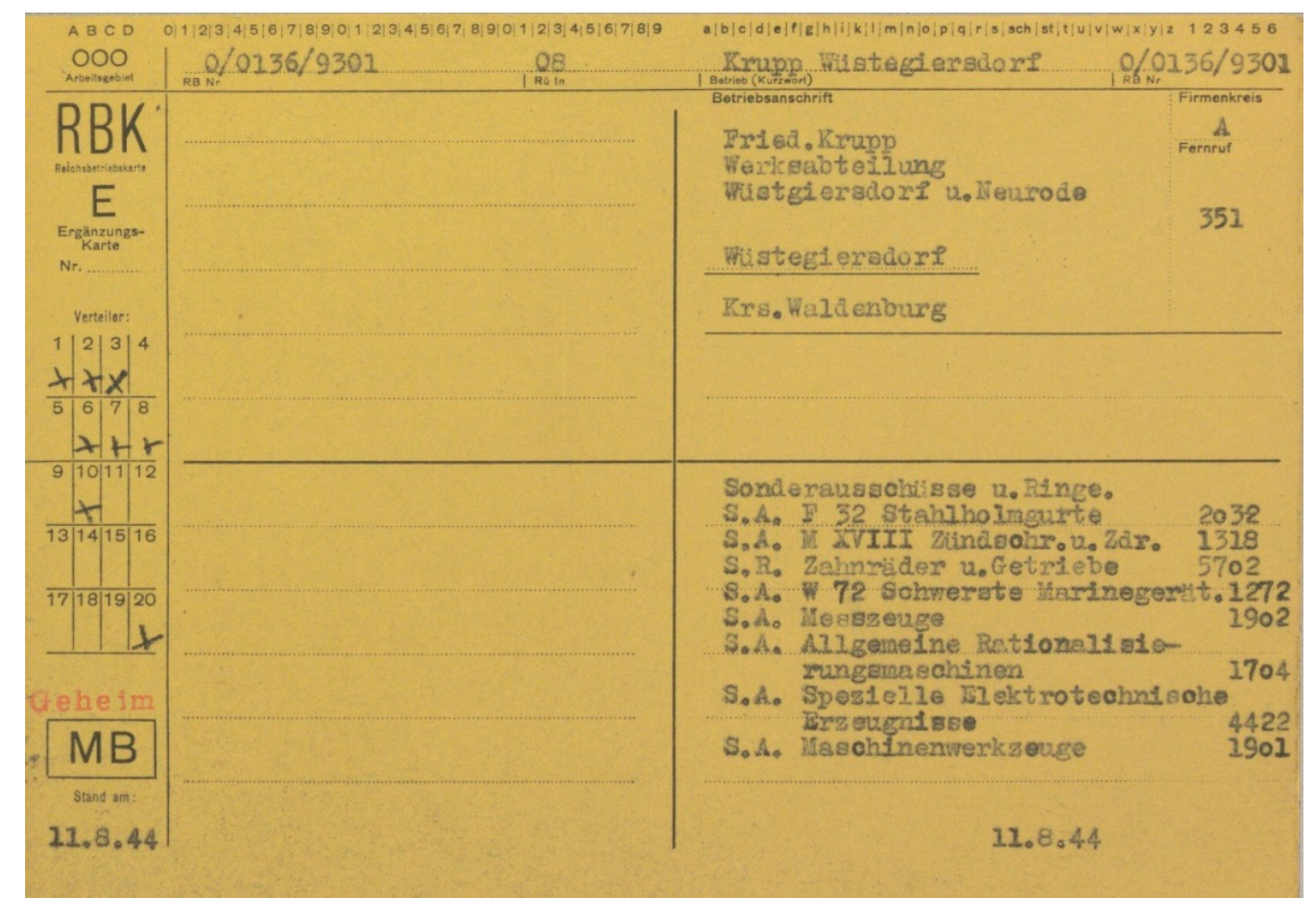
3.2. Spatial and Additional Data

The research used data from the archives (aerial photos and topographic maps), as well as contemporary data (orthophotomaps and LiDAR). Complex queries were run against the documents kept by the National Collection of Aerial Photography Archive (NCAP) in Scotland and the National Archives (NARA) in the United States, which resulted in the discovery of a unique aerial photo. The research employed a scan of an original paper photo from the NARA archives. The scan of an identical photo from NCAP was most probably a photocopy of the original that is currently held in NARA. The NCAP copy must have been made after the War was over and remained in Great Britain, while the original photo was transported to the USA. The employed photo was characterized by mechanical damage, including some warping, scratches and dust marks. The scale of the photo is 1:43,000; it was taken on 20.02.1945 with an RB30 camera with a 30-cm negative format and a lens of 200.47 mm focal length, and it covered the entire Riese complex. The photo in question was scanned at 800 DPI and saved in a .tiff format. The authors used it as a main resource to delineate the topography of the explored camps. In the last stage of conducted research, the team also uncovered an aerial photo from May 1939, located in the archives of the German Bundesarchiv. However, said photo was not employed in the described research.
The authors were also able to find four topographic maps (Messtischblatt series, scale 1:25,000; 1904, 1924, 1934, and 1939) that were used in the interpretation of the aerial photo from 1945. The contemporary data that were used in the research include data obtained via the use of LiDAR (Light Detection and Ranging, density of six points/sq. m and altimeter accuracy of about ±15 cm, acquisition date: 2011), as well as an orthophotomap (GSD 0.25 m, acquisition time: 2016). The LiDAR data came from a project by the Head Office of Geodesy and Cartography that was carried out for the whole of Poland. These data are available for free to public administration entities and for scientific purposes. The spatial data were augmented by witness testimony from the Jewish prisoners of AL Riese collected shortly after the War (1945–1949) and kept by the Jewish Historical Institute in Warsaw, and by the testimony of Abraham Kajzer [34,35], who saved some of the notes he took in the camp and later had them published, as well as testimonies made public by the Freie Universität Berlin [36].

3.3. Data Processing

In order to perform a proper integration of spatial data with actual data, it was also necessary to perform an orthorectification of aerial photographs [37], as well as the georeferencing of historical maps [38]. The orthorectification of the 1945 aerial photo was performed using PCI Geomatica software (PCI Geomatica OrthoEngine, Quebec, PQ, Canada). The outcome of that process is something called an image georeference, in which the photo is geocoded with a map projection and can be integrated with other spatial data in Geographic Information System (GIS) software. Indeed, the orthorectification process has to be applied in this case due to the very significant land leveling (land undulations) in the area under study, reaching 670 meters. The lack of the required camera interior information meant [39] that it was necessary to conduct that process using indirect georeferencing carried out via a spatial (independent) space resection [40]. The first step was to establish the interior orientation parameters based on the identification of fiducial markers and measurements between each set of fiducials along the edge of the photo. In our case, that meant that both the principal points, as well as the lens distortion, were unknown factors. However, we could ignore the lens distortion factor as it is secondary factor in comparison to other sources of deformation as result from, inter alia, the physical state of the paper copy of the archive photo. Additionally the analysed area is in the middle of the photo, where the distortions are much less prevalent than at the edges.
Elements of exterior orientation were established using Ground Control Points (GCPs) visible on the picture below and whose spatial coordinates are known. The exterior orientation was also accomplished using GCPs. The orthorectification orthoadjustment process used 23 GCP points and seven Check Points (CP). GCP and CP were natural features identified both on the historical aerial photo and on the existing orthophotomap from 2016 with a terrain pixel of 0.25 m. The flat (X, Y) coordinates ware measured from orthophotomap, and heights (Z) from the existing DTM, with the resolution of 1 m × 1 m, based on LiDAR data. Natural features mostly encompassed road junctions and corners of structures. Unfortunately, this meant that nonoptimal targets, such as building corners, had to be chosen sometimes, as they were the only relatively static objects in the landscape that were identifiable in both the historical and the contemporary context [41]. The analysis of the precision of orthorectification orthoadjustment was based on the Root Mean Square Error (RMSE). An accuracy of 12.9 m (0.3 mm in a 1:43,000 reference scale) was taken as an acceptable RMSE. Orthoadjustment of the 1945 aerial photo achieved an RMSE of 12.40 m (on Check Points). We found this result as satisfactory and corresponding to the scale and quality of archival source photo.
Georeferencing of historical maps was conducted with the use of ArcGIS software (ArcGIS v.10.6, ESRI, Inc., Redlands, CA, USA). The authors obtained the RMSE factor for georeferencing of a topographical map (Messtischblatt series) of around 6 m with 10 ground control points with affine transformation. The georeferencing process that used second-order polynomial transformation did not improve the results. It can therefore be assumed that the map sheets used did not display more complex distortions, which could be removed with a higher transformation order.
To visualize the digital elevation model created using the LiDAR data, the authors applied Relief Visualization Toolbox (RVT v. 2.2.1, Research Centre of the Slovenian Academy of Sciences and Arts, Ljubljana, SLO) software [42]. Sky-View Factor (SVF) [43], Openness [44], and Local Dominance [43] were used for each of the analysed areas, and many different testing parameters were applied. The high usefulness of SVF with a radius of 5 m, Openness Positive (OP) with a radius of 10 m, and Local Dominance (LD) with the radius filter parameters set to (minimum/maximum: 10 m) is worth noting here. Well-applied parameters allowed us to emphasize topographic elements that were important from the point of view of the conducted research. After being successfully orthorectified, the historical aerial image was subjected to a visual photointerpretation in order to produce plans of the camps for the tested areas. Visual photointerpretation was conducted with the support of topographic maps and actual orthophotographs of the same area. Moreover, the authors used complementary spatial data, such as LiDAR data products, to improve the interpretation of camp object features. All spatial data have been integrated using ArcGIS software. A walkover survey was also carried out, which resulted in a technical description of the remains of the camp facilities.

4. Results

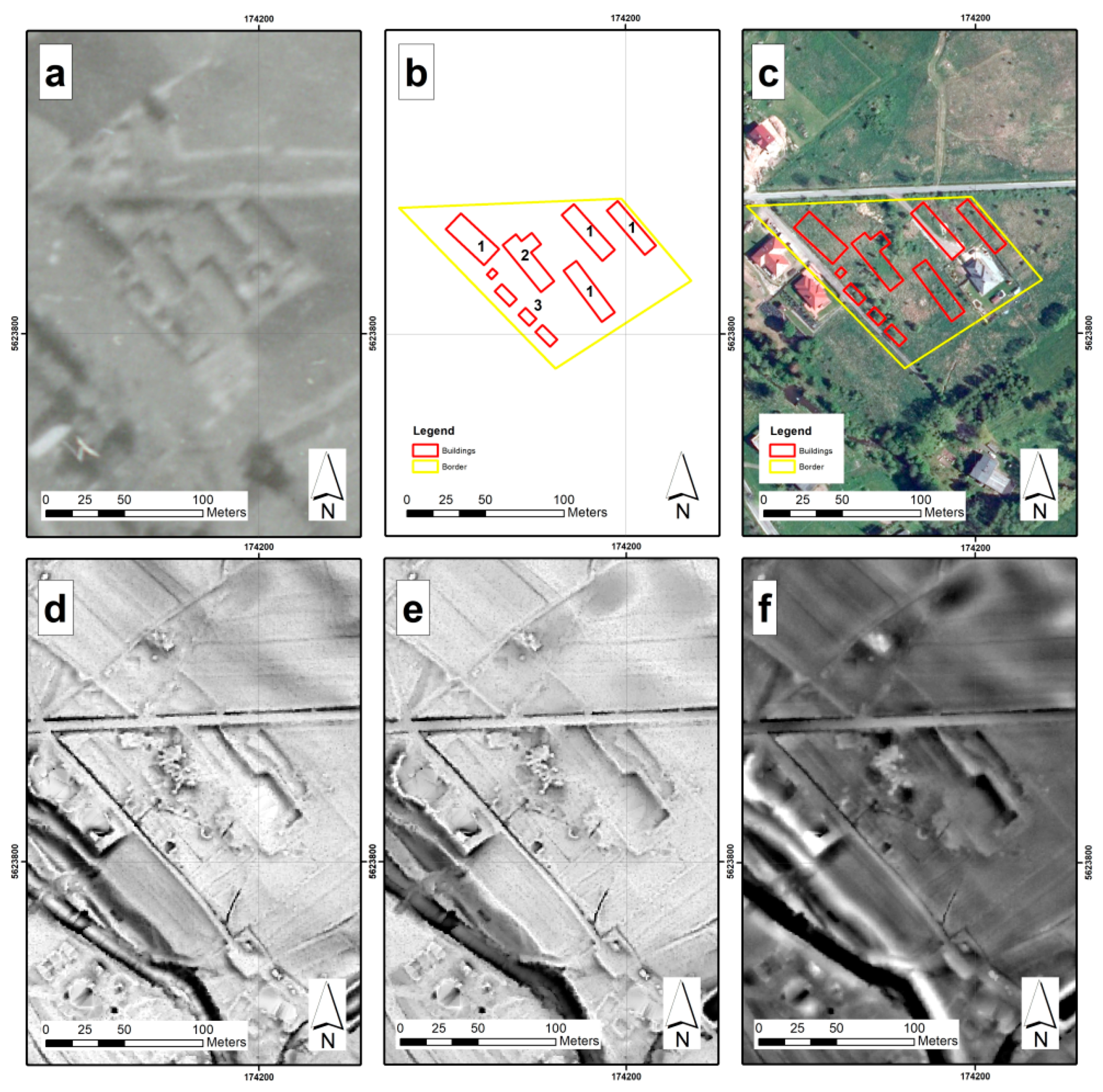
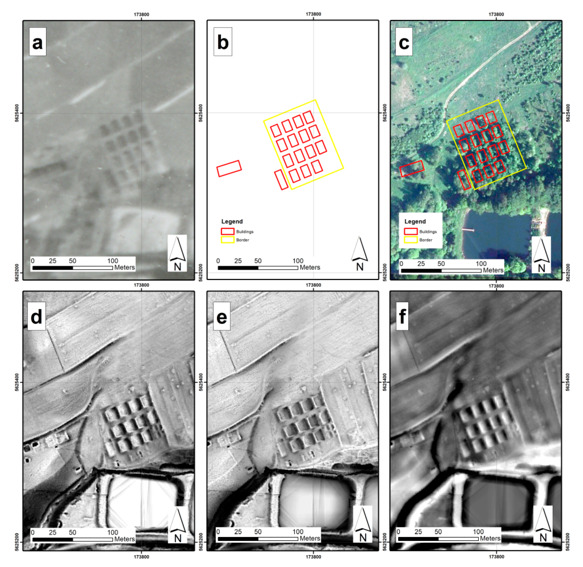
4.1. Spatial Data Integration and Photointerpretation

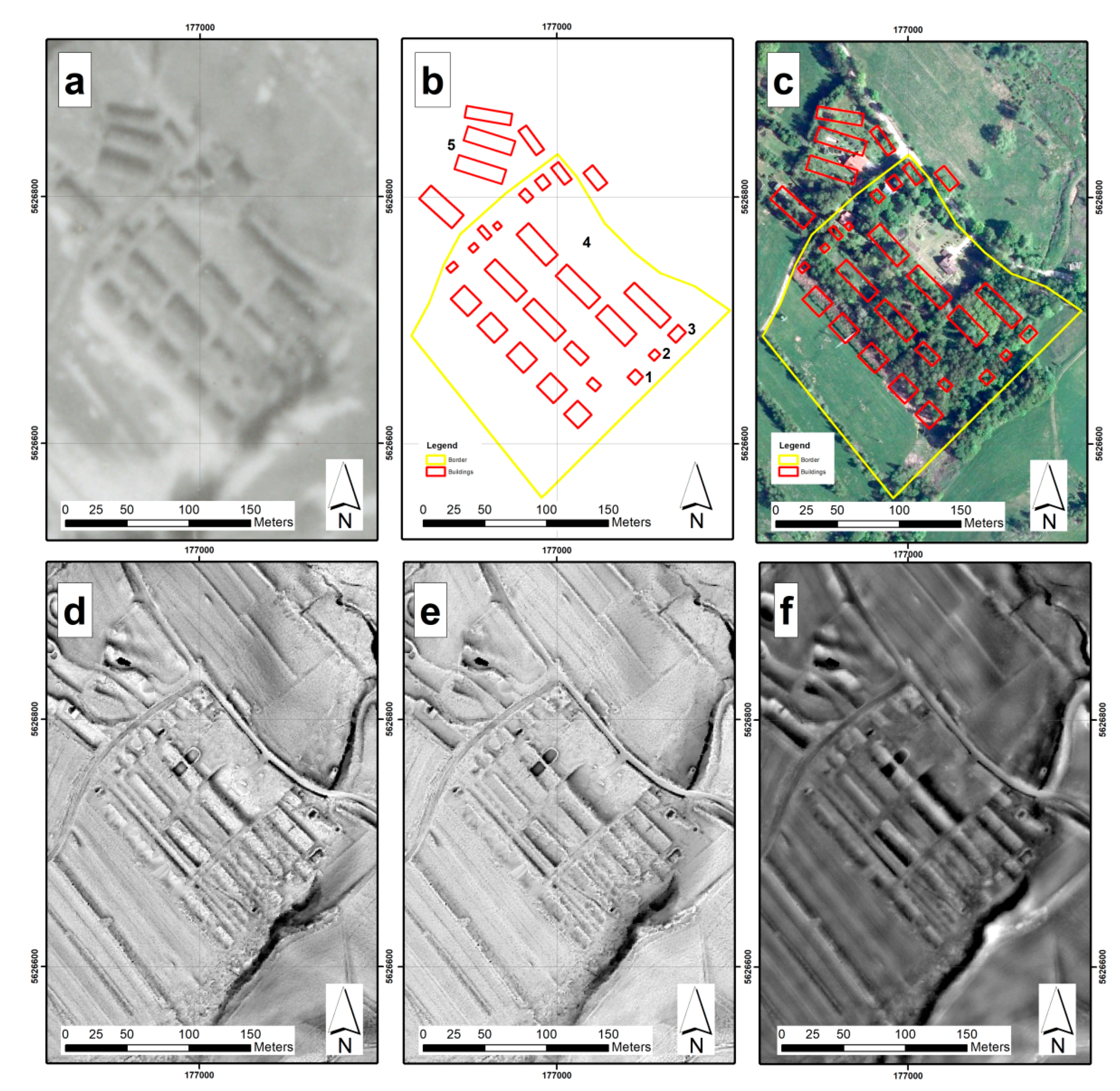
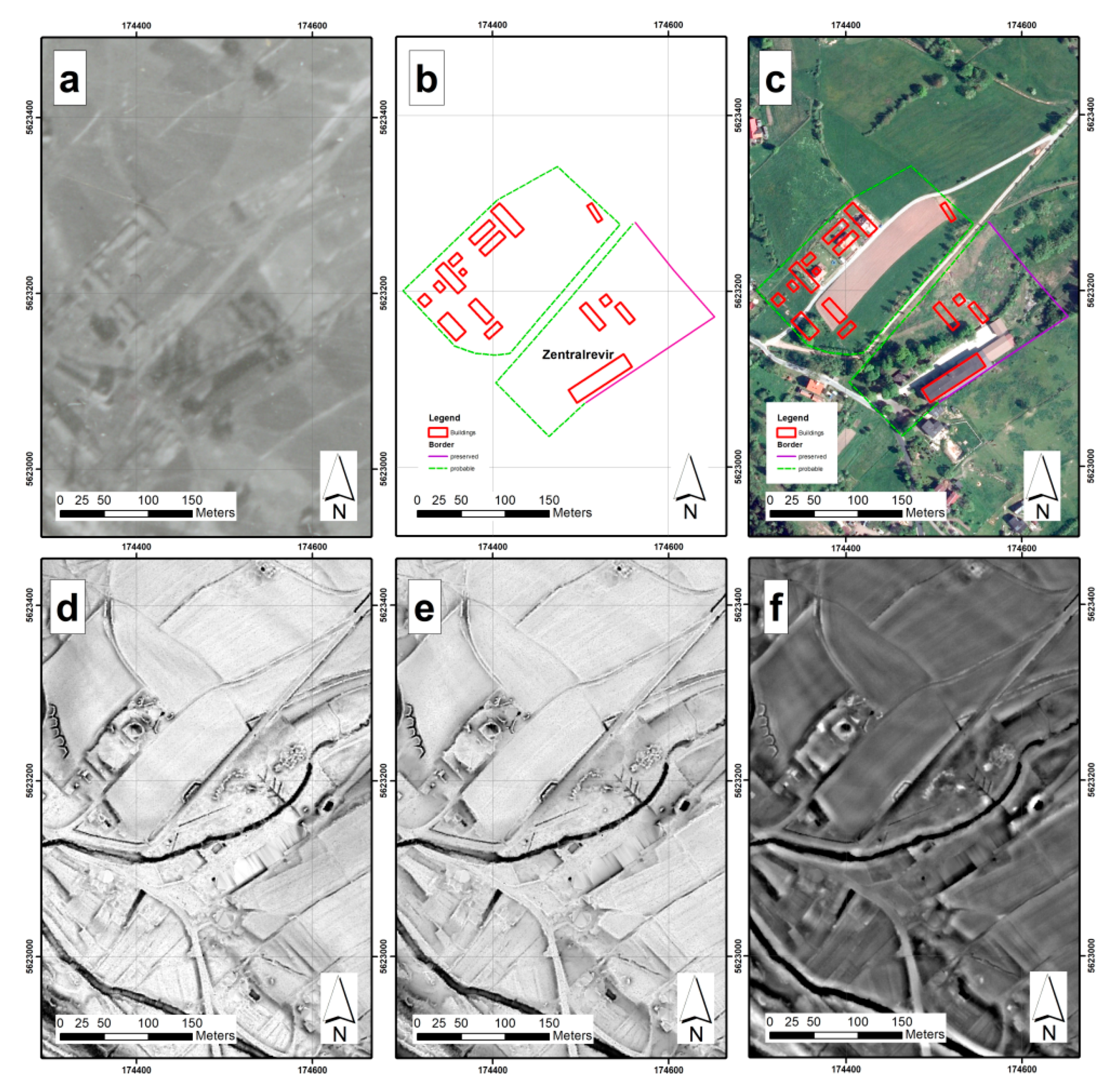
4.1.1. Wolfsberg Labour Camp

The scale of the aerial photo does not allow for the application of direct features to delineate the camp area. Therefore, indirect features were used in that task: the surrounding roads, the footpaths, and the general outline of the buildings seen on the archive photo (Figure 3a) that received the SVF treatment (5 m: Figure 3d), which additionally emphasized the topography of the terrain. The area of the camp, when established via use of the aforementioned processes, amounted to 3.60 hectares. The authors was able to identify 29 buildings, which ranged in size from 30 sq. m to around 490 sq. m (Figure 3b). It was not possible to locate some of the camp objects mentioned by witnesses in their testimonies; the location of the small wooden huts with a round base, as well as that of the dugouts, was never established. Such small objects are not visible on the 1945 photo, and the changes to the land did not withstand the passage of time. At the moment, the southern part of the former camp area is covered by trees, as can be seen on the ortophotomap (Figure 3c). It is there that one can find the remains of the camp buildings: the foundation for the barracks and the kitchen (Figure 4), the lavatory, the water tank (Figure 5), the garbage dump, and the sump. The wooden and metal elements of the barracks were looted, and one can observe many signs of conscious salvage of brick material on many surviving buildings. Different sizes and divisions of the former camp buildings allow for the formation of a hypothesis that the buildings were put up very rapidly by an unskilled workforce consisting of prisoners. It seems that the construction was carried out according to executive orders and not construction plans or blueprints. The fact that there was no outside plastering on the buildings points to their temporary nature and the limited timeframe of their usage (1–2 years). Now, there are some single-family houses located in the remainder of the former camp area.

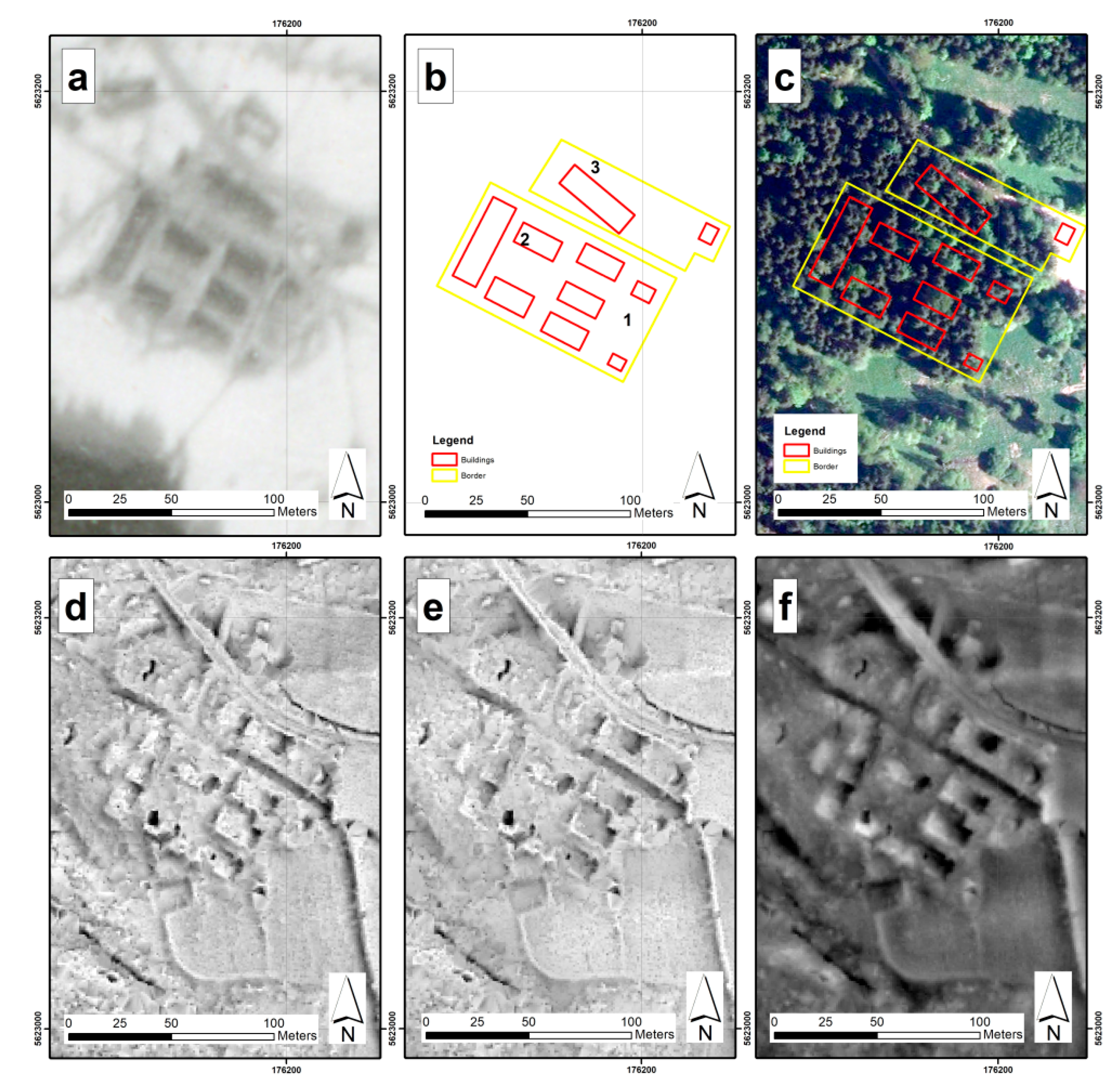
4.1.2. Kaltwasser Labour Camp

Based on the interpretation of the aerial photo, we were able to identify five barracks, which some of the witnesses mentioned in their testimonies:
Four long buildings with big windows and glass doors were surrounded by a wire fence. Apart from buildings numbered from 2 to 5, there was also a kitchen there”.
[45]
The camp was different from Auschwitz. Four long buildings with big windows and glass doors. Surrounded by razor wire fence. Apart from buildings with rising numbers, there was also a kitchen there”.
[45]
Two smaller buildings are also visible; however, their function was impossible to establish with certainty. The outlines of the buildings established based on the aerial photo were compared using an OP (10 m: Figure 6e), which allowed for the partial modification of their outlines. One of the smaller buildings (recognized on the aerial photo: Figure 6a) has remained in good shape until today. A field analysis allowed to identify it as a cesspool/overflow separator (concrete, constructed using formwork), which transported sewage outside of the camp area (Figure 7). Clay pipes connect to the separator. The camp’s fence was delineated using indirect features, the surrounding roads and camp infrastructure. The camp area was around 1.12 hectares (Figure 6b). Most of the fence elements in the analysed labour camps consisted of wooden poles that supported a razor wire framework. The entry gate was also made of wood. Due to their makeshift nature, the fence and gate were the first structures to fall to looters shortly after the War. Despite the fact that within the area of the former Kaltwasser camp one can still recognize fragments of the foundation of the camp’s buildings, the terrain was divided into smaller plots (the southwestern part of it), probably in order to prepare them for sale. At the southeastern border of the camp, a single-family house was built (Figure 6c and Figure 8).

4.1.3. Dörnhau Labour Camp

The camp was located by the road from Dörnhau (now called Kolce) to Tannhausen (now Jedlinka). The photo from 1945 (Figure 9a) shows two separate camps: one in the north with camp barracks and one in the south, where a linen textile factory was located (Figure 10a).
The factory also served as a medical facility for sick prisoners (called Zentralrevier in German), and was very often erroneously called a hospital. We were not able to delineate the camp’s borders based on the photo. They were instead established based on indirect features. Together, the two parts of the camp covered 5.33 hectares. OP (10 m: Figure 9e) was used in the interpretation process, which, despite a loss in the perception of topography in the case of the Dörnhau camp, allows for a better visual perception in comparison to SVF.
The remains of the barbed wire fence that surrounded the southern part of Dörnhau from the factory side are still visible today (Figure 9c). The fence was constructed using premade concrete elements that supported a razor wire framework (Figure 10b). The latter is also still visible today.
The ortophotomap also shows the fence (Figure 9c), which is not visible on the photo from 1945. The objects in the northern part of the camp (the barracks) were dismantled after 1945 and today the area is covered in private houses. However, in the areas that were not built over, even today one can still see a few elements of the camp’s foundations. Very often, the outline of the camp’s barracks can only be identified by using terrain irregularities and spotting individual bricks lying around that used to form the foundation. The existing construction materials have been damaged through exposure to the elements.

4.1.4. Säuferwasser Labour Camp

The scale of the aerial photo from 1945 (Figure 11a) does not allow for the application of direct features to delineate the camp area. Therefore, indirect features were used in that task: the surrounding roads, the footpaths, and the general outline of the buildings seen on the archive photo that received the SVF treatment (5 m: Figure 11d), which additionally emphasized the topography of the terrain. The area of the camp for prisoners, when established via use of the aforementioned processes, amounted to 0.58 hectares. The authors was able to identify 10 buildings, ranging in size from 40 sq. m to around 540 sq. m (Figure 11b). At the moment, the southern part of the former camp area is covered by trees, as can be seen on the ortophotomap (Figure 11c). It is there that one can find the remains of the camp buildings: the foundation for the barracks (Figure 12 and Figure 13) and the kitchen, the lavatory, the water tank, garbage dump, and the sump. The wooden and metal elements of the barracks were looted, and one can observe signs of conscious salvage of brick material on many surviving buildings.

4.1.5. Wüstegiersdorf Labour Camp

The photo from 20 February 1945 (Figure 14a) shows the camp in the last stage of its functioning. Most probably, the camp where the forced laborers were kept was not evacuated in February 1945 but continued operating until May of the same year. Seventeen camp buildings were located in the process of interpreting the photos (Figure 14b). They were surrounded by a fence. The camp area was around 0.65 hectares. Apart from the area for the forced labourers, two other buildings were also located nearby: one close to the western border of the camp (most probably the headquarters building) and another one, whose purpose was difficult to establish. After a SVF (5 m: Figure 14d) and OP analysis, the second building turned out to have been a cluster of three buildings, instead of, as was previously assumed, a single entity. It could have functioned as the kitchen, the workshop, and the warehouse. Some elements of the former camp survived to the present day (Figure 14c). The foundation of the barracks and administrative buildings is still visible. The area is covered by a mixed forest in the south and is one of the few camps whose remains are still visible today (Figure 15 and Figure 16) and where the terrain was not built over. It is believed that, in the future, Wüstegiersdorf can be appropriately commemorated because the problem of purchase of land with existing buildings would not exist here.

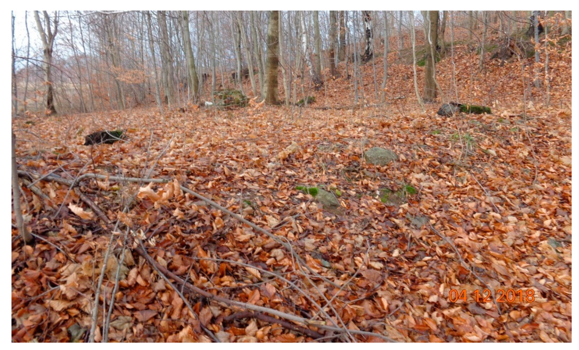
4.2. Field Survey of the Remains of the Forced Labour Camps

The description of the technical condition of the remains of the AL camps remains based on field studies conducted in December 2018 and in September 2019. Field tests took into account the state of the camps’ remains, masonry structure inspection, as well as manual testing of building materials (e.g., splitting test, manual material strength test, etc.). The observations were carried out at the AL Riese subcamps: Wolfsberg, Kaltwasser, Märzbachtal, Dörnhau, and Säuferwasser. The following problems were observed among the remains of the studied camps:
(1)
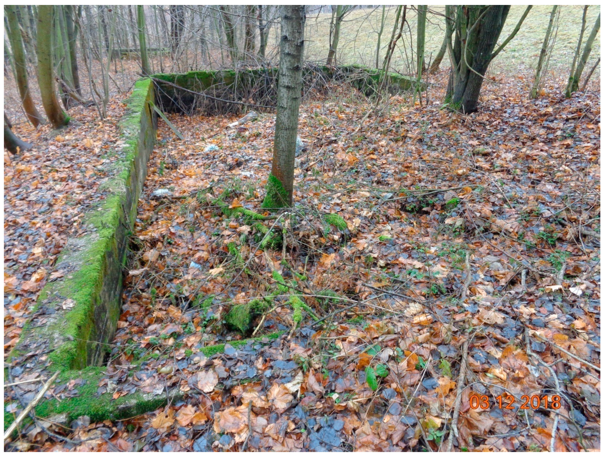
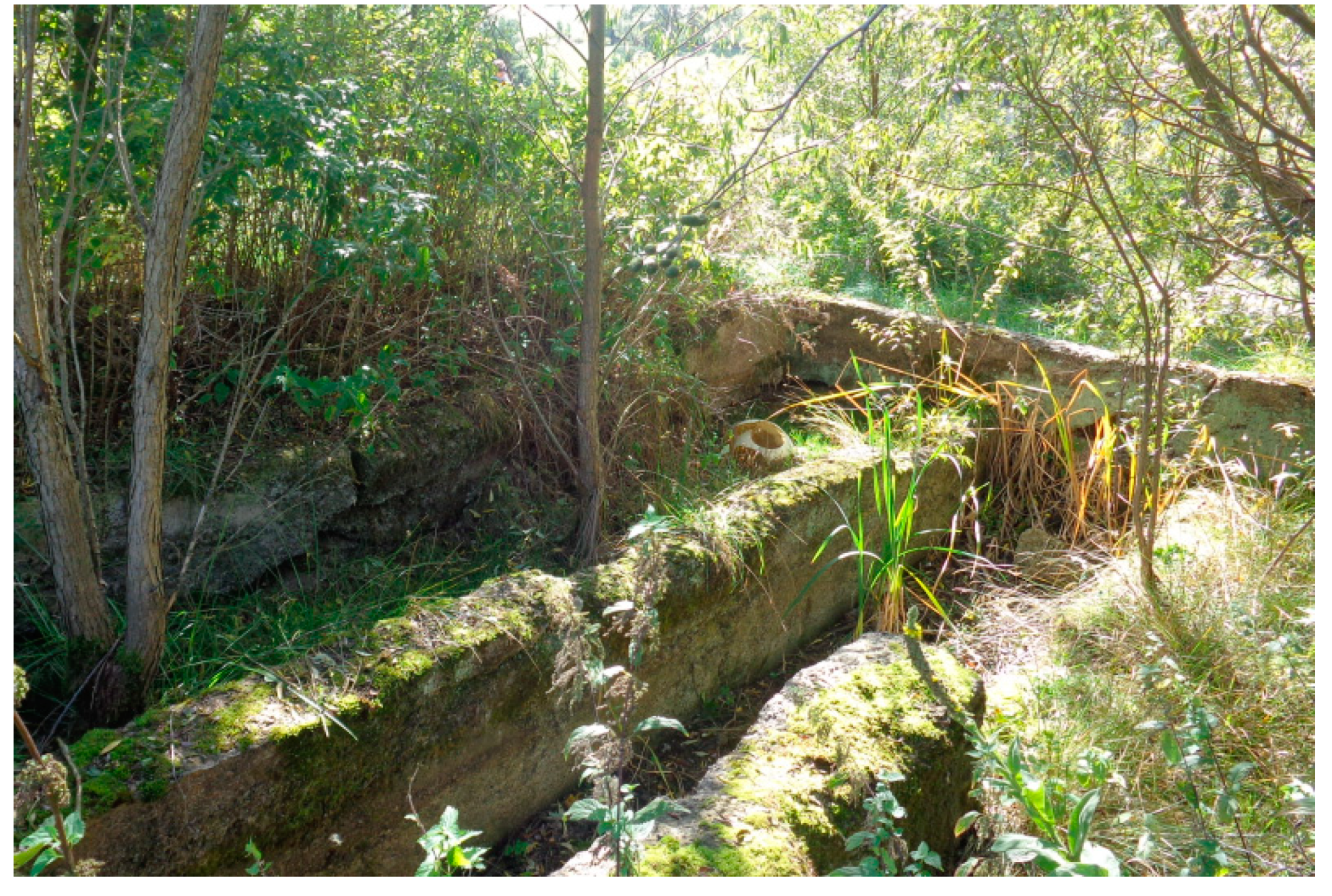
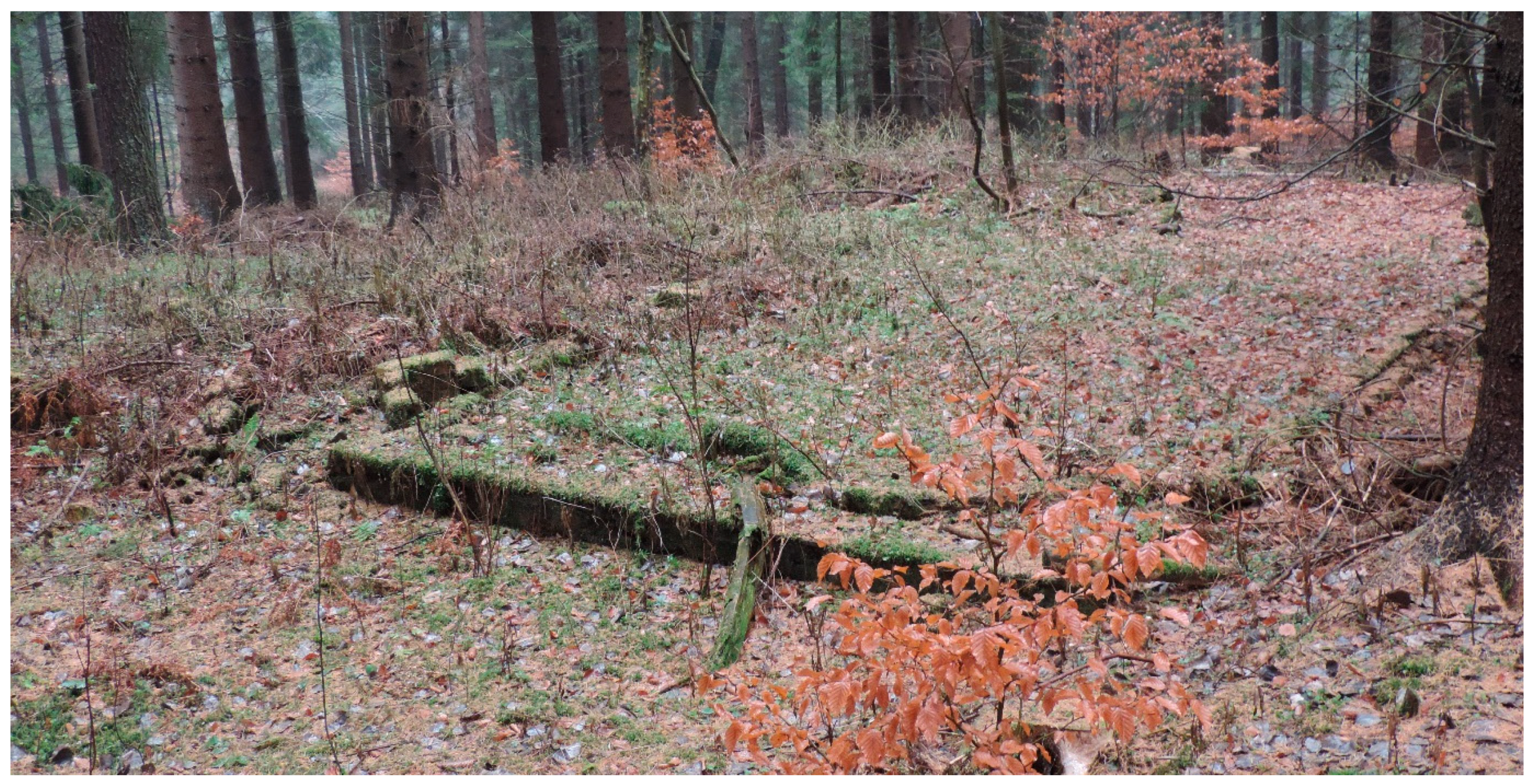
The lack of specific plans of camps is visible on the layout of the structure and foundation of its elements (e.g., Figure 3 and Figure 9). The camp facilities are located randomly and against their functionality and operational safety. Camp kitchens and food warehouses, as well as the baths, are often situated in low grounds and morasses. Camp baths were located as close as possible to streams or surface intakes (common in depressions) of water, not taking into account sewage outflows (corresponding slopes). The camp barracks were placed not in regular rows at appropriate intervals but tightly in favorable terrain, which adapted to the needs of the camp at the lowest cost of the work done.
(2)
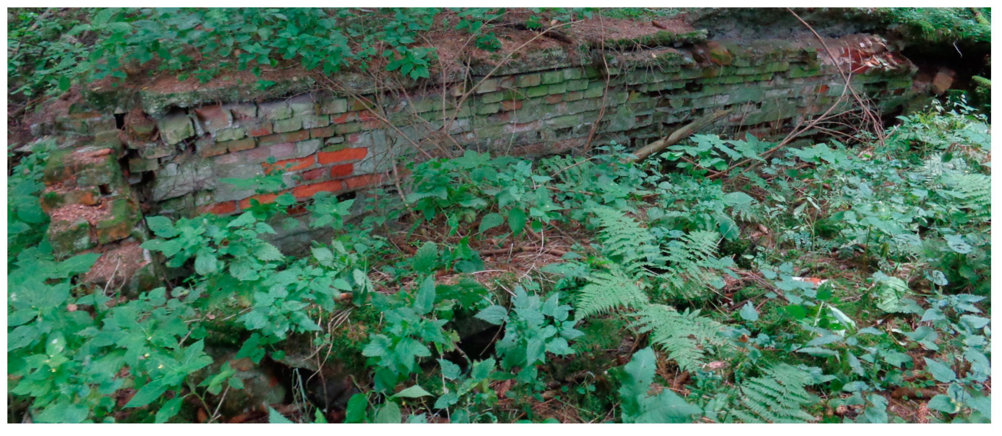
The lack of proper load-bearing walls and low quality of concrete structures were observed (Figure 4). Exterior walls with a height of 1 to 1.5 meters made of brickwork having a thickness of 25 to 40 cm; the cement-lime mortar layer is uneven and varies from 1 to 3 cm thick. Partitions were made from a single brick wall. Concrete constructions lacked steel reinforcements. The concrete mix contained ill-sorted aggregate composed of local rocks: Carboniferous gravel (weathered Carboniferous conglomerate) and broken fragments of Neogene basalts.
(3)
Lack of proper horizontal and vertical leveling of external walls (Figure 4 and Figure 7)—the levels were transferred using formwork boards.
(4)
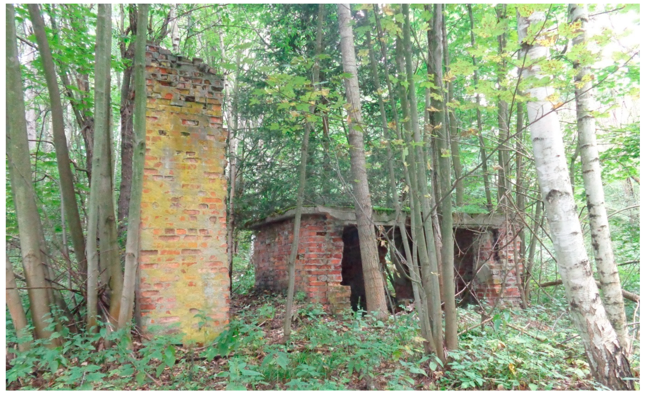
The primary building materials for building the most of the camp facilities were mortar-bonded bricks and wooden elements (recently not present). The red ceramic brick (Figure 4) was bonded using mortar made of cement mixed with lime and ill-sorted aggregate. Not less than 20% of bricks came from recycling (demolition). The recycled bricks were poor quality and in bad condition of using.
(5)
No traces of plastering were found (Figure 4).
(6)
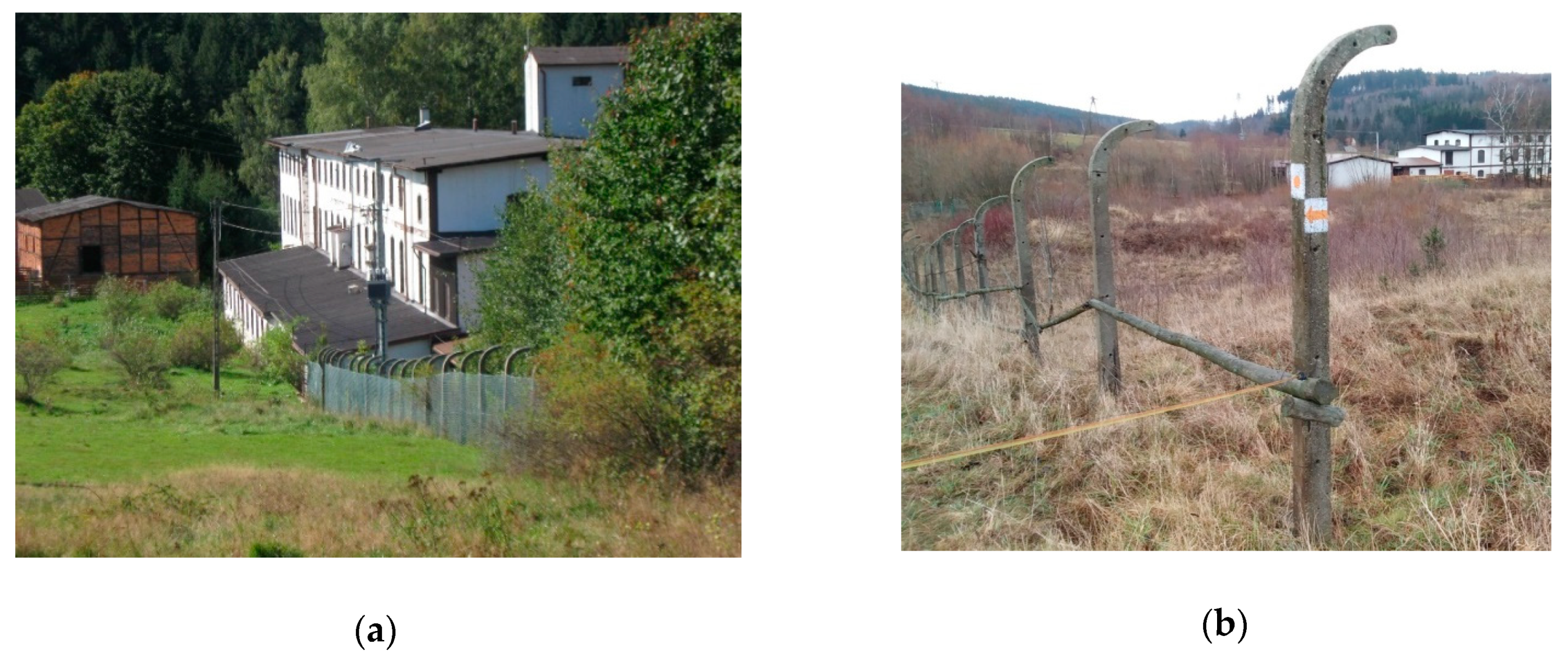
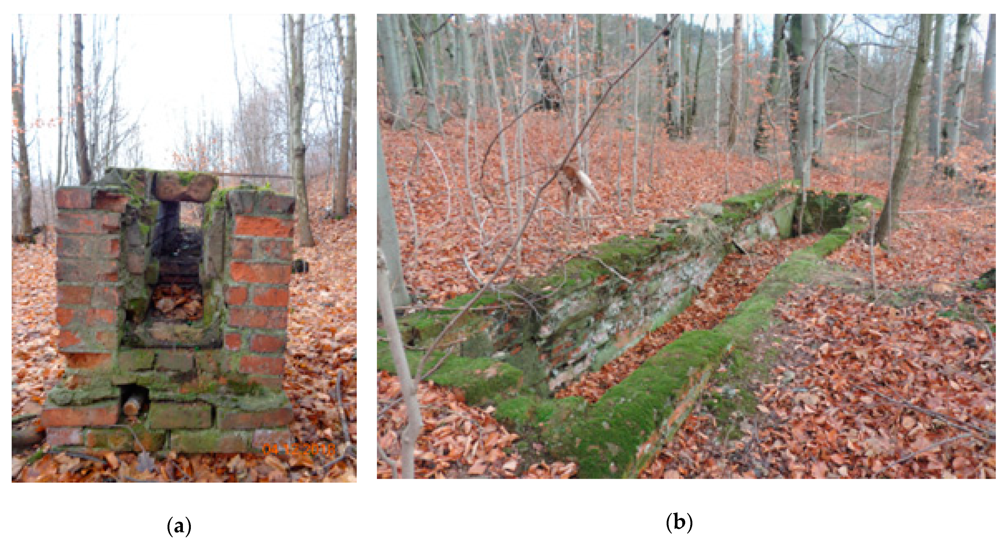
Freestanding chimneys (Figure 16) built without foundation footing and internal reinforcement, no refractory brick inside.
(7)
Lack of installation elements of metal plumbing.
(8)
Camp prisoners used raw water collected from neighboring streams and ponds rather than water wells. No traces of water treatment installations have found during archival research as well as a field survey.
The camp facilities were erected by unskilled prisoners from readily available building materials, according to executive orders rather than construction plans. The field survey of camp objects described above clearly indicates the intentionally defective execution of both construction and field works. The camp buildings built in such a way would have their durability for up to 2 years. The structures were easy to demolish due to the significant amount of wooden elements as well as faulty masonry. Presumably, the demolition could be carried out without the use of specialized equipment, only with the help of a truck or with small amounts of military explosives.
The results of field research indicate the need to carry out archaeological research documenting both the layout and structure of the camp, as well as the manner of implementation of individual camp objects. Due to the progressive degradation of residues and changing land use, the rescue nature of such efforts should be emphasized.

5. Discussion

The application of archive aerial footage, LiDAR−derived products, GIS tools, and witnesses’ testimony allowed for the identification of the areas of the camps. This proved that it is possible to integrate multisource spatial data in order to create a more complete terrain analysis.
Archive aerial footage is an important source of knowledge about the topography of the analysed terrain. Despite the poor condition of the photo, the team was able to delineate the topographic objects connected with camp structures. Their importance is even higher given that the analysed terrain has changed significantly throughout the years and no materials that describe the camp’s topography have survived until today. The scale (1:45,000) of the employed photo did not allow for a highly precise delineation of the camp’s borders, and the shape of some of the buildings could only be estimated. The identification of the functions of some facilities was also impossible. However, despite all those drawbacks, it is the only photo of the camp from the time when the camps were in operation. Created camp plans differ extensively from those drafted, for example, for Lager Nordeney in Alderney [45]. The analysis of the latter used a series of photos taken between 1941 and 1942 and interpretative repots and maps. That is why continuing the search in various archives and being on the lookout for aerial footage, as well as witness testimony, is so important.
The free-of-charge LiDAR data [46,47], and the products that were created on the basis of said data, allowed us, in a couple of cases, to correct the interpretation of the aerial photo. However, the data density was too low, meaning that some of the camp facilities that have survived until today were not captured on the derivatives (SVF, OP). Those objects were identified based on a walkover survey. When it comes to the continued analysis of the other nine camps that made up AL Riese, the authors are considering a new, more accurate point cloud. LiDAR products of a higher quality would limit the necessity of conducting terrain research of areas with limited accessibility (private plots). Moreover, it is also worth considering the application of an automatic procedure of object analysis [48]. Such an approach could then be applied to camps that were not built over. For areas that are characterized by a mixture of surviving historic objects and contemporary buildings, archives should remain the main resource.
The research that was carried out allowed the team to classify the camps into two groups, according to the state of the surviving objects after 75 years. The first was Wüstegiersdorf and Säuferwasser, which were completely erased from common memory. Their remains are still visible in the field, but they are becoming more and more difficult to reach with every passing year. The second group (Wolfsberg, Kaltwasser, and Dörnhau) includes objects that were partially dismantled and built over.
A lot of time passed in Poland after the War before many of the places connected to Nazi criminal activity were properly commemorated and entered into social memory. Take, for example, the Treblinka Death Camp: after many political, social, and financial problems, the camp’s inmates were commemorated with a monument only 19 years after the end of the War [49]. Smaller camps are being forgotten and their locations are not commemorated in any way.
When it comes to the AL Riese camp area, one has to remember that both the public land as well as the private land that used to belong to the Third Reich according to Polish law—based on the provisions of agreements from Yalta and Potsdam, and later specified in the international agreements between Poland and Germany (first the GDR, later the FRG)—became the property of the Polish state [50,51]. Most of the camps in the Owl Mountains were located in mountainous areas; the barracks and fences were dismantled and other remains succumbed to the flora growth that is now masking the camp topography. Some of the more attractive former camp areas that were located in the vicinity of urban areas (like Wolfsberg or Kaltwasser) became the property of local owners at the end of the 1980s and the beginning of the 1990s due to the fact that people forgot about local history 45 years after the WWII ended. The sale and lack of preservation of those areas in any of the local spatial development plans and regulations on places of national memory meant that, starting in 2015, building permits for those plots were granted to the owners. That is why some of the Wolfsberg and Kaltwasser camp areas were partially built over between 2015 and 2020.
Some areas and facilities that saw the slave work of hundreds of inmates—the mine shafts, the underground tunnels, and other concrete buildings—were not destroyed; they are now a tourist attraction for people coming from all over the world [23]. They have been attracted in part by the rumours of treasure hidden in underground trains [52] and stories about weapons development programs.
However, the remains of the camps themselves are badly preserved or their memory has already completely eroded, despite them leaving a significant footprint in terms of all the people who lived, worked, and died in that place. One could ask whether the commemoration of camp facilities is necessary at all. Should the analysis of AL Riese be continued? The answer to that question can be found in the so-called death marches organized by private people or groups of people who are trying to find the truth on their own based on information available to them on the Internet, or that they gleaned in conversation with local people. Those people are trying to find the camps they heard about and light a candle in memory of the victims [53].
There are positive examples of the re-institution of World War II places of memory in contemporary Poland. Treblinka railway station, which used to belong to the Polish National Railways, was ceded to the Treblinka Museum in 2018 [54]. At the moment, that station where transport trains filled to the brim with camp victims were held is being reshaped in order to properly commemorate it. The spatial development plans are being changed. Similar action could be taken in Säuferwasser and Wüstegiersdorf, as those areas have not been completely built over. Both camp areas could be secured and used as places of memory. The inactive factory at the Dörnhau labour camp could be turned into a local museum to honour martyrs.
The research results allow one to support the decision-making process connected to the future of those forgotten facilities and should increase the awareness of such places. Moreover, another outcome should be increased support for processes connected with the popularization of knowledge regarding heritage sites and their importance in history. The research that was conducted allowed the team to recreate the topography of the camps, which in the future should make it a lot easier to grant legal protection to the camp remains.

6. Conclusions

The delineated borders of the labour camps and the location of their facilities and buildings were confirmed by the analysis of the aerial photograph from 1945 combined with LiDAR products (SVF, OP, LD), as well as the results of field tests and archival testimonies from witnesses. Field inspection of the construction remains indicated intentionally faulty construction, which deliberately reduced the durability of the buildings and made them easy to demolish.
Field studies revealed a significant degree of degradation of the camp remains. Recently, the main threat has been the development of the area, natural degradation of the structural remains, and a lack of knowledge about this aspect of local history. This is strongly associated with the gradual blurring of social and institutional memory and the commercial mythologization of the Riese facility.
The authors believe that it is urgent to continue this research and to share the results with both the scientific community and the local community. It is through such efforts that the collective memory of this dark period of history can be renewed. It should also be noted that this is one of the lesser-known aspects of Holocaust history and thus requires ongoing research. Experience gathered in the course of the research indicated that archives can and do contain significant resources unknown to the wider scientific community that are crucial to the reconstruction of the history of the Riese facility. The Arbeitslager Riese case study proves that there are camps that are overgrown and are becoming forgotten. The stocktaking process of all the places connected to various labour camps and the support received from local authorities is a hopeful sign that it is possible to implement efficient protection and commemoration of objects that are material elements of our historical heritage.

Author Contributions

Conceptualization, S.R., P.B. and P.L.; methodology, S.R.; field work collection, P.B., P.L., A.B., and A.K.; digital image processing, A.K.; GIS analysis and interpretation, S.R., A.K. and P.L.; writing—original draft preparation, S.R., P.L., P.B., A.K. and A.B.; visualization, S.R.; project administration, P.B.; funding acquisition, P.B. All authors have read and agreed to the published version of the manuscript.

Funding

This research was funded by Faculty of Geodesy and Cartography within the Research Grants Program, grant number PW 504/03791/1060/40.000101.

Acknowledgments

We are grateful to the following institutions for helping us during walkover surveys: Walim Culture and Tourism Center, municipality of Głuszyca and Walim, Gross-Rosen Museum in Rogoźnica, Underground City Osówka Ltd. and Walimskie Drifts Company. This work used early research of A. Kamola contained in his MSc thesis entitled " Methodology for the Integration of Multi-Source Spatial Data Based on the German Project Riese" (MSc thesis, supervisor: S. Różycki).

Conflicts of Interest

The authors declare no conflict of interest.

References

  1. Pettitt, J. Introduction: New perspectives on Auschwitz. Holocaust Stud. 2019, 1–11. [Google Scholar] [CrossRef] [Green Version]
  2. Schute, I. De vuilstort van Kamp Westerbork, Gemeente Aa en Hunze; RAAP Archeologisch Adviesbureau, B.V.: Weesp, The Netherlands, 2013. [Google Scholar]
  3. Abate, D.; Colls, C.S. A multi-level and multi-sensor documentation approach of the Treblinka extermination and labor camps. J. Cult. Herit. 2018, 34, 129–135. [Google Scholar] [CrossRef]
  4. Karski, K.; Różycki, S.; Schwarz, A. Memories of Recent Past. Objectives and Results of Non-invasive Archeological Research Project at KL Plaszow Memorial Site. Analecta Archaeol. Ressoviensia 2017, 12, 221–246. [Google Scholar]
  5. ‘Forgotten’ Nazi Camp on British Soil Revealed by Archaeologists. Available online: https://www.nationalgeographic.co.uk/history-and-civilisation/2020/03/forgotten-nazi-camp-british-soil-revealed-archaeologists (accessed on 29 April 2020).
  6. Jasinski, M.E. Predicting the past—Materiality of Nazi and post-Nazi camps: A Norwegian perspective. J. Histor. Archaeol. 2018, 22, 639–661. [Google Scholar] [CrossRef]
  7. Grabowski, R.; Olsen, B.; Petursdottir, Þ.; Witmore, C. Teillager 6 Sværholt: The Archaeology of a World War II Prisoner of War Camp in Finnmark, Arctic Norway. Fennosc. Archaeol. 2014, 31, 3–24. [Google Scholar]
  8. Różycki, S.; Michalski, M.; Kopówka, E. Obóz Pracy Treblinka I: Metodyka Integracji Danych Wieloźródłowych; ELPIL, Faculty of Geodesy and Cartography: Siedlce, Poland, 2017. [Google Scholar]
  9. Early, R. Excavating the World War II Prisoner of War camp at La Glacerie, Cherbourg, Normandy. In Prisoners of War; Mytum, H., Carr, G., Eds.; Springer: New York, NY, USA, 2013; pp. 95–115. [Google Scholar]
  10. Colls, C.S. Holocaust Archaeologies: Approaches and Future Directions; Springer: New York, NY, USA, 2015. [Google Scholar]
  11. Colls, C.S. Holocaust archaeology: Archaeological approaches to landscapes of Nazi genocide and persecution. J. Conflict Archaeol. 2012, 7, 70–104. [Google Scholar] [CrossRef]
  12. Charlesworth, A.; Addis, M. Memorialization and the ecological landscapes of Holocaust sites: The cases of Plaszow and Auschwitz-Birkenau. Landsc. Res. 2002, 27, 229–251. [Google Scholar] [CrossRef] [Green Version]
  13. Schute, I. Collecting artifacts on Holocaust sites: A critical review of archaeological research in Ybenheer, Westerbork, and Sobibor. Int. J. Histor. Archaeol. 2018, 22, 593–613. [Google Scholar] [CrossRef]
  14. Antkowiak, M.; Völker, E. Dokumentiert und konserviert. Ein Außenlager des Konzentrationslagers Sachsenhausen in Rathenow, Landkreis Havelland. Archäologie Berl. Brandenbg. 2000, 1999, 147–149. [Google Scholar]
  15. Carr, G.; Colls, C.S. Taboo and sensitive heritage: Labour camps, burials and the role of activism in the Channel Islands. Int. J. Herit. Stud. 2016, 22, 702–715. [Google Scholar] [CrossRef] [Green Version]
  16. Mineo, S.; Pappalardo, G. Sustainable Fruition of Cultural Heritage in Areas Affected by Rockfalls. Sustainability 2020, 12, 296. [Google Scholar] [CrossRef] [Green Version]
  17. Wang, J.-J. Flood risk maps to cultural heritage: Measures and process. J. Cult. Herit. 2015, 16, 210–220. [Google Scholar] [CrossRef]
  18. Kropáček, J.; Neckel, N.; Tyrna, B.; Holzer, N.; Hovden, A.; Gourmelen, N.; Hochschild, V. Repeated glacial lake outburst flood threatening the oldest Buddhist monastery in north-western Nepal. Nat. Hazards Earth Syst. Sci. 2015, 15, 2425–2437. [Google Scholar] [CrossRef] [Green Version]
  19. Nicu, I.C.; Stoleriu, C.C. Land use changes and dynamics over the last century around churches of Moldavia, Bukovina, Northern Romania—Challenges and future perspectives. Habitat Int. 2019, 88, 101979. [Google Scholar] [CrossRef]
  20. Poria, Y. Establishing cooperation between Israel and Poland to save Auschwitz Concentration Camp: Globalising the responsibility for the Massacre. Int. J. Tour. Pol. 2007, 1, 45–57. [Google Scholar] [CrossRef]
  21. Ochałek, A.; Jabłoński, M.; Lipecki, T.; Jaśkowski, W. Methodology of historical underground objects inventory surveys–contribution. Geoinform. Pol. 2018, 17, 43–51. [Google Scholar] [CrossRef] [Green Version]
  22. Gutterman, B. A Narrow Bridge to Life; Berghahn Books: New York, NY, USA, 2008. [Google Scholar]
  23. Stach, E.; Pawłowska, A.; Matoga, Ł. The Development of Tourism at Military-Historical Structures and Sites–A Case Study of the Building Complexes of Project Riese in the Owl Mountains. Pol. J. Sport Tour. 2014, 21, 36–41. [Google Scholar] [CrossRef] [Green Version]
  24. Kajzer, A.; Ostoja, A. Za Drutami Śmierci; Wydawn: Łódzkie, Poland, 1962. [Google Scholar]
  25. Jabłoński, M.; Lipecki, T.; Jaśkowski, W.; Ochałek, A. Virtual Underground City Osówka. Geol. Geophys. Environ. 2016, 42, 77–78. [Google Scholar] [CrossRef] [Green Version]
  26. Sula, D. Arbeitslager Riese: Filia KL Gross-Rosen; Muzeum Gross-Rosen: Wałbrzych, Poland, 2003. [Google Scholar]
  27. Secrets of the Sowie Mountains, Vol I–IV. Available online: http://www.warsawvoice.pl/WVpage/pages/article.php/2878/article (accessed on 29 April 2020).
  28. Kryza, R.; Fanning, C.M. Devonian deep-crustal metamorphism and exhumation in the Variscan Orogen: Evidence from SHRIMP zircon ages from the HT-HP granulites and migmatites of the Góry Sowie (Polish Sudetes). Geodin. Acta 2007, 20, 159–175. [Google Scholar] [CrossRef]
  29. Megargee, G.P. Encyclopedia of Camps and Ghettos. 1933–1945; Indiana University Press: Bloomington, IN, USA, 2009. [Google Scholar]
  30. Brion, P. REIMAHG, Geschichte in Bildern—REIMAHG—A Pictorial History; Eigen Verlag: Kahla München, Germany, 2009. [Google Scholar]
  31. Blatman, D. The Death Marches: The Final Phase of Nazi Genocide; Harvard University Press: Cambridge, UK, 2011. [Google Scholar]
  32. Testimony of the Former Prisoner Moniek Kaufman, Sign; 301/1939; The Jewish Historical Institute in Poland: Warsaw, Poland.
  33. Testimony of the Former Prisoner Norbert Szeinowicz, Sign; 301/1939; The Jewish Historical Institute in Poland: Warsaw, Poland.
  34. Sula, D. Na Granicy Życia i Śmierci. Biografistyka Pedag. 2017, 2, 127–144. [Google Scholar] [CrossRef] [Green Version]
  35. Elmanowska, B. Abraham Kajzer i jego tekst z obozów koncentracyjnych–studium przypadku. Autobiografia. Literatura. Kultura. Media 2015, 4, 149–168. [Google Scholar]
  36. 950 Interviews aus der Sammlung der USC Shoah Foundation. Available online: http://transcripts.vha.fu-berlin.de/ (accessed on 29 April 2020).
  37. Bożek, P.; Janus, J.; Mitka, B. Analysis of Changes in Forest Structure using Point Clouds from Historical Aerial Photographs. Remote Sens. 2019, 11, 2259. [Google Scholar] [CrossRef] [Green Version]
  38. Affek, A. Georeferencing of historical maps using GIS, as exemplified by the Austrian Military Surveys of Galicia. Geogr. Pol. 2013, 86, 375–390. [Google Scholar] [CrossRef]
  39. Pinto, A.T.; Gonçalves, J.A.; Beja, P.; Pradinho Honrado, J. From archived historical aerial imagery to informative orthophotos: A framework for retrieving the past in long-term socioecological research. J. Remote Sen. 2019, 11, 1388. [Google Scholar] [CrossRef] [Green Version]
  40. Kurczyński, Z. Fotogrametria, 1st ed.; PWN S.A.: Warsaw, Poland, 2014. [Google Scholar]
  41. Sevara, C.; Verhoeven, G.; Doneus, M.; Dragantis, E. Surfaces from the Visual Past: Recovering High-Resolution Terrain Data from Historic Aerial Imagery for Multitemporal Landscape Analysis. J. Archaeol. Method Theory 2018, 25, 611–642. [Google Scholar] [CrossRef] [Green Version]
  42. Kokalj, Ž.; Hesse, R. Airborne Laser Scanning Raster Data Visualization: A Guide to Good Practice (Vol. 14); Založba ZRC: Ljubljana, Slovakia, 2017. [Google Scholar]
  43. Kokalj, Ž.; Zakšek, K.; Oštir, K.; Pehani, P.; Čotar, K.; Somrak, M.; Kokalj, Ž. Relief Visualization Toolbox, ver. 2.2. 1 Manual. Remote Sens. 2016, 3, 398–415. [Google Scholar]
  44. Doneus, M. Openness as Visualization Technique for Interpretative Mapping of Airborne LiDAR Derived Digital Terrain Models. Remote Sens. 2013, 5, 6427–6442. [Google Scholar] [CrossRef] [Green Version]
  45. Colls, C.S.; Colls, K. Reconstructing a Painful Past: A Non–Invasive Approach to Reconstructing Lager Norderney in Alderney, the Channel Islands. In Visual Heritage in the Digital Age; Ch’ng, E., Gaffney, V., Chapman, H., Eds.; Springer: London, UK, 2013; pp. 119–146. [Google Scholar]
  46. Zalewska, A. The ‘gas-scape’ on the eastern front, Poland (1914–2014): Exploring the material and digital landscapes and remembering those ‘twice-killed’. In Conflict Landscapes and Archaeology from Above; Stichelbaut, B., Cowley, D., Eds.; Ashgate Publishing: Farnham, UK, 2016; pp. 147–165. [Google Scholar]
  47. Wroniecki, P.; Jaworski, M.; Kostyrko, M. Exploring free LiDAR derivatives. A user’s perspective on the potencial of readily available resources in Poland. Archaeol. Pol. 2015, 53, 611–616. [Google Scholar]
  48. Witharana, C.H.; Ouimet, W.B.; Johnson, K.M. Using LiDAR and GEOBIA for automated extraction of eighteenth—Late nineteenth century relict charcoal hearths in southern New England. GISci. Remote Sen. 2018, 55, 183–204. [Google Scholar] [CrossRef]
  49. Rusiniak, M. Obóz Zagłady Treblinka II w Pamięci Społecznej (1943-1989); Neriton: Warsaw, Poland, 2008. [Google Scholar]
  50. Góralski, M.W. Polish-German Relations and the Effects of the Second World War; Polish Institute of International Affairs: Warszaw, Poland, 2006. [Google Scholar]
  51. Ghassemi, A. Expropriation of Foreign Property in International Law. Ph.D. Thesis, The University of Hull, Hull, UK, 1999. [Google Scholar]
  52. Madej, J.; Łój, M.; Porzucek, S.; Jaśkowski, W.; Karczewski, J.; Tomecka-Suchoń, S. The geophysical truth about the ‘Gold Train’in Walbrzych, Poland. Archaeol. Prospect. 2018, 25, 137–146. [Google Scholar] [CrossRef]
  53. Marsz Śmierci. Available online: https://www.goryponadchmurami.pl/2011/08/marsz-smierci.html (accessed on 29 April 2020).
  54. Różycki, S.; Kopówka, E.; Zalewska, N. Obóz zagłady Treblinka II. Topografia Zbrodni; Wydział Geodezji i Kartografii PW, Elpil: Siedlce, Poland, 2019. [Google Scholar]
Figure 1. Study Area: (a) overview map with the marked location (red point) (b) and map with the former camps selected for the study. Coordinate grid: UTM Zone 34 N (EPSG: 32634). © OpenStreetMap.
Remotesensing 12 01802 g001
Figure 2. Production chart for the Krupp facility in Wustgiersdorf (Głuszyca) that includes a list of the produced elements. Source: Bundesarchiv R3/2006.
Remotesensing 12 01802 g002
Figure 3. Labour camp AL Wolfsberg: (a) Aerial photo taken in February 1945 (© NARA), (b) reconstruction of camp based on ’45 photo: 1—bath, 2—kitchen, 3—water tank, 4—assembly ground, 5—barracks of the camp HQ and the staff, (c) recent orthophoto of camp area with outlined camp plan (© Head Office of Geodesy and Cartography in Poland), (d) SVF image (radius 5 m), (e) Openness positive image (radius 10 m), (f) Local Dominance image (min./max.: 10 m – 10 m). Coordinate grid: UTM Zone 34 N (EPSG: 32634).
Remotesensing 12 01802 g003
Figure 4. Remains of the camp kitchen, AL Wolfsberg; photo P. Lewandowski.
Remotesensing 12 01802 g004
Figure 5. Remains of the camp’s water tank, AL Wolfsberg; photo P. Lewandowski.
Remotesensing 12 01802 g005
Figure 6. Labour camp AL Kaltwasser: (a) ’45 aerial photo (© NARA), (b) reconstruction of camp based on ’45 photo: 1—inmates’ barracks, 2—kitchen and suspected HQ, 3—cesspool, (c) recent orthophoto of camp area with outlined camp plan (© Head Office of Geodesy and Cartography in Poland), (d) SVF image (radius 5 m), (e) Openness positive image (radius 10 m), (f) Local Dominance image (min./max.: 10 m – 10 m). Coordinate grid: UTM Zone 34 N (EPSG: 32634).
Remotesensing 12 01802 g006
Figure 7. Concrete remains of the presumed cesspool, AL Kaltwasser; photo P. Lewandowski.
Remotesensing 12 01802 g007
Figure 8. Contemporary house built on the site of the former AL Kaltwasser camp; photo P Lewandowski.
Remotesensing 12 01802 g008
Figure 9. Labour Camp AL Dörnhau: (a) ’45 aerial photo (© NARA), (b) reconstruction of camp based on ’45 photo, (c) recent orthophoto of camp area with outlined camp plan (© Head Office of Geodesy and Cartography in Poland), (d) SVF image (radius 5 m), (e) Openness positive image (radius 10 m), (f) Local Dominance image (min./max.: 10 m – 10 m). Coordinate grid: UTM Zone 34 N (EPSG: 32634).
Remotesensing 12 01802 g009
Figure 10. The remains of the fence surrounding the former AL Dörnhau camp: (a) the southern part of the factory building (white walls) and a row of concrete fence posts with modern fencing mesh; (b) the row of concrete post fence is restricting the former camp area from the northeast; in the background factory buildings; photos: A. Burakowski.
Remotesensing 12 01802 g010
Figure 11. Labour camp AL Säuferwasser: (a) ’45 aerial photo (© NARA), (b) reconstruction of camp based on ’45 photo: 1—presumed camp kitchen, 2—“roll call” square, 3—suspected HQ, (c) recent orthophoto of camp area with outlined camp plan (© Head Office of Geodesy and Cartography in Poland), (d) SVF image (radius 5 m), (e) Openness positive image (radius 10 m), (f) Local Dominance image (min./max.: 10 m – 10 m). Coordinate grid: UTM Zone 34 N (EPSG: 32634).
Remotesensing 12 01802 g011
Figure 12. Remains of the barrack’s brick underpinning, former AL Säuferwasser camp; photo P. Lewandowski.
Remotesensing 12 01802 g012
Figure 13. Remains of the barrack’s foundation, AL Säuferwasser; photo P. Bylina.
Remotesensing 12 01802 g013
Figure 14. Presumed forced labour camp for Krupp factory in Wüstegiersdorf (Krupp Lager für die Zwangsarbeiter Wüstegiersdorf): (a) ’45 aerial photo (© NARA), (b) reconstruction of camp based on ’45 photo, (c) recent orthophoto of the area with outlined camp plan (© Head Office of Geodesy and Cartography in Poland), (d) SVF image (radius 5 m), (e) Openness positive image (radius 10 m), (f) Local Dominance image (min./max.: 10 m – 10 m). Coordinate grid: UTM Zone 34 N (EPSG: 32634).
Remotesensing 12 01802 g014
Figure 15. Artificially formed terraces with remains of a chimney, Krupp LZA Wüstegiersdorf; photo P. Lewandowski.
Remotesensing 12 01802 g015
Figure 16. The remains of the barracks of the Krupp LZA Wüstegiersdorf: (a) remains of the chimney; please, note the two-sided access to the furnace, photo P. Lewandowski; (b) the remains of the presumed pantry, photo P. Bylina.
Remotesensing 12 01802 g016

