
Combination of Hyperspectral and Machine Learning to Invert Soil Electrical Conductivity

 ,
,
Abstract
:
1. Introduction
2. Materials and Methods
2.1. Study Area
2.2. Data Collection
2.2.1. Soil Sampling and Laboratory Analysis
2.2.2. Hyperspectral Measurement and Data Processing
2.3. Extraction of Salinization Related Factors
2.3.1. Spectral Reflectance Transformation and Selection of Spectral Indices
- (1)
- Deviation of arch (DOA) [47]
- (2)
- Salinity index (conventional)

| Acronym | Spectral Index | Formula | Reference |
|---|---|---|---|
| SI-T | Salinity Index | [48] | |
| SI | Salinity Index | [48] | |
| SI1 | Salinity Index 1 | [49] | |
| SI2 | Salinity Index 2 | [49] | |
| SI3 | Salinity Index 3 | [49] | |
| S1 | Salinity Index I | [50] | |
| S2 | Salinity Index II | [50] | |
| S3 | Salinity Index III | [50] | |
| Int1 | Intensity Index 1 | [51] | |
| Int2 | Intensity Index 2 | [51] | |
| NDSI | Normalized Difference Salinity Index | [52] |
- (3)
- Two-band (2D) index
| Acronym | Spectral Indices | Formula | Reference |
|---|---|---|---|
| DI | Difference Index | [53] | |
| RI | Ratio Index | [53] | |
| NDI | Normalized Index | [54] | |
| PI | Product Index | [54] | |
| SI | Sum Index | [54] | |
| RDVI | Renormalized Difference Vegetation Index | [55] | |
| NPDI | Nitrogen Planar Domain Index | [56] |
2.3.2. Topographical Factors
2.4. Machine Learning Algorithms
2.4.1. Feature Selection Based on Gradient Boosting
2.4.2. Modeling Strategies and Accuracy Assessment
2.5. Kriging
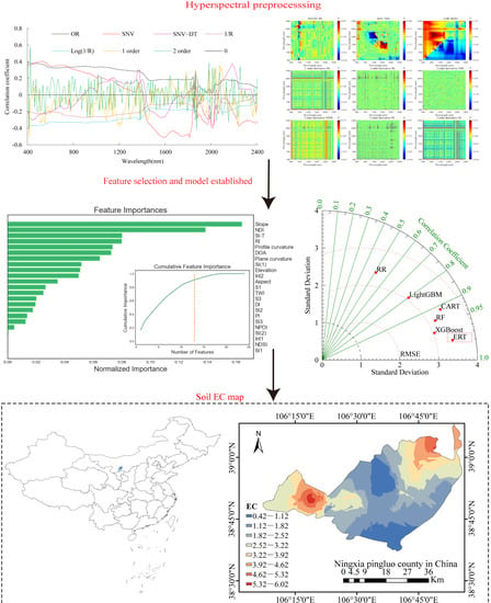
3. Results
3.1. The Spectral Characteristic of the Soil Samples
3.2. Correlation Analysis of Spectral Reflectance and EC
3.3. Model Inversions and Comparisons
3.3.1. Feature Selection and Importance Analysis
3.3.2. Establishment and Verification of Soil EC Inversion Models
3.3.3. Testing of Predictive Models
3.4. Digital Soil Maps of EC
4. Discussion
4.1. Hyperspectral Pre-Processing
4.2. Feature and Model Selection
4.3. Spatial Distribution of Soil Salinity
4.4. Uncertainty Analysis of Soil EC Inversion Model
5. Conclusions
Author Contributions
Funding
Institutional Review Board Statement
Informed Consent Statement
Data Availability Statement
Conflicts of Interest
References
- Metternicht, G.I.; Zinck, J.A. Remote sensing of soil salinity: Potentials and constraints. Remote Sens Environ. 2003, 85, 1–20. [Google Scholar] [CrossRef]
- Zhang, T.T.; Qi, J.G.; Gao, Y.; Ouyang, Z.T.; Zeng, S.L.; Zhao, B. Detecting soil salinity with MODIS time series VI data. Ecol. Indic. 2015, 52, 480–489. [Google Scholar] [CrossRef]
- Tóth, G.; Hermann, T.; da Silva, M.R.; Montanarella, L. Monitoring soil for sustainable development and land degradation neutrality. Environ. Monit. Assess. 2018, 190, 57. [Google Scholar] [CrossRef] [PubMed] [Green Version]
- Huang, F.; Ding, X.X.; Li, W.W.; Jia, H.T.; Wei, X.R.; Zhao, X.N. The effect of temperature on decomposition of the different parts of maize residues in a Solonchak. Catena 2021, 201, 105207. [Google Scholar] [CrossRef]
- Nachshon, U. Cropland soil salinization and associated hydrology: Trends, processes and examples. Water 2018, 10, 1030. [Google Scholar]
- Zaman, M.; Shahid, S.A.; Heng, L. Guideline for Salinity Assessment, Mitigation and Adaptation Using Nuclear and Related Techniques; Springer: Cham, Switzerland, 2018. [Google Scholar]
- Chen, Z.X.; Ren, J.Q.; Tang, H.J.; Shi, Y.; Leng, P.; Liu, J.; Wang, L.M.; Wu, W.B.; Yao, Y.M.; Hasiyuya. Progress and perspectives on agricultural remote sensing research and applications in China. J. Remote Sens. 2016, 20, 748–767. [Google Scholar]
- Tripathi, A.; Tiwari, R.K. A Simplified Sub-Surface Soil Salinity estimation using Synergy of Sentinel-1 SAR and Sentinel-2 multispectral satellite data, for early stages of wheat crop growth in Rupnagar, Punjab, India. Land Degrad. Dev. 2021, 32, 3905–3919. [Google Scholar] [CrossRef]
- Peng, J.; Wang, J.Q.; Xiang, H.Y.; Teng, H.F.; Liu, W.Y.; Chi, C.M.; Niu, J.L.; Guo, Y.; Shi, Z. Comparative study on hyperspectral inversion accuracy of soil salt content and electrical conductivity. Spectrosc. Spectr. Anal. 2014, 34, 510–514. [Google Scholar]
- Wang, J.Z.; Ding, J.L.; Yu, D.L.; Ma, X.K.; Zhang, Z.P.; Ge, X.Y.; Teng, D.X.; Li, X.H.; Liang, J.; Lizaga, I.; et al. Capability of Sentinel-2 MSI data for monitoring and mapping of soil salinity in dry and wet seasons in the Ebinur Lake region. Xinjiang, China. Geoderma 2019, 353, 172–187. [Google Scholar] [CrossRef]
- Sun, X.; Gao, Y.; Wang, D.E.; Chen, J.H.; Zhang, F.G.; Zhou, J.B.; Li, Y.H. Stoichiometric variation of halophytes in response to changes in soil salinity. Plant Biol. 2017, 19, 360–367. [Google Scholar] [CrossRef]
- Gorji, T.; Sertel, E.; Tanika, A. Monitoring soil salinity via remote sensing technology under data scarce conditions: A case study from Turkey. Ecol. Indic. 2017, 74, 384–391. [Google Scholar] [CrossRef]
- Viscarra Rossel, R.A.; Behrens, T.; Ben-Dor, E.; Brown, D.J.; Demattê, J.A.M.; Shepherd, K.D.; Shi, Z.; Stenberg, B.; Stevens, A.; Adamchuk, V.; et al. A global spectral library to characterize the world’s soil. Earth Sci. Rev. 2016, 155, 198–230. [Google Scholar] [CrossRef] [Green Version]
- Douglas, R.K.; Nawar, S.; Alamar, M.C.; Mouazen, A.M.; Coulon, F. Rapid prediction of total petroleum hydrocarbons concentration in contaminated soil using Vis-NIR spectroscopy and regression techniques. Sci. Total Environ. 2018, 616, 147–155. [Google Scholar] [CrossRef] [PubMed] [Green Version]
- Ding, J.L.; Yu, D.L. Monitoring and evaluating spatial variability of soil salinity in dry and wet seasons in the Werigan–Kuqa Oasis, China, using remote sensing and electromagnetic induction instruments. Geoderma 2014, 235–236, 316–322. [Google Scholar] [CrossRef]
- Nawar, S.; Buddenbaum, H.; Hill, J. Estimation of soil salinity using three quantitative methods based on visible and near-infrared reflectance spectroscopy: A case study from Egypt. Arab. J. Geosci. 2015, 8, 5127–5140. [Google Scholar] [CrossRef]
- Zhang, Z.P.; Ding, J.L.; Zhu, C.M.; Wang, J.Z. Combination of efficient signal pre-processing and optimal band combination algorithm to predict soil organic matter through visible and near-infrared spectra. Spectrochim. Acta A Mol. Biomol. Spectrosc. 2020, 240, 118553. [Google Scholar] [CrossRef] [PubMed]
- Kooistra, L.; Wanders, J.; Epema, G.F. The potential of field spectroscopy for the assessment of sediment properties in river floodplains. Anal. Chim. Acta 2003, 484, 189–200. [Google Scholar] [CrossRef]
- Wang, H.F.; Chen, Y.W.; Zhang, Z.T.; Chen, H.R.; Chai, H.Y. Quantitatively estimating main soil water-soluble salt ions content based on Visible-near infrared wavelength selected using GC, SR and VIP. PeerJ 2019, 7, e6310. [Google Scholar] [CrossRef]
- Yu, X.; Liu, Q.; Wang, Y.B.; Liu, X.Y.; Liu, X. Evaluation of MLSR and PLSR for estimating soil element contents using visible/near-infrared spectroscopy in apple orchards on the Jiaodong peninsula. Catena 2016, 137, 340–349. [Google Scholar] [CrossRef]
- Hong, Y.S.; Liu, Y.L.; Chen, Y.Y.; Liu, Y.F.; Yu, L.; Liu, Y.; Cheng, H. Application of fractional-order derivative in the quantitative estimation of soil organic matter content through visible and near-infrared spectroscopy. Geoderma 2019, 337, 758–769. [Google Scholar] [CrossRef]
- Hong, Y.S.; Chen, S.C.; Zhang, Y.; Chen, Y.Y.; Lei, Y.; Liu, Y.F.; Liu, Y.L.; Cheng, H.; Liu, Y. Rapid identification of soil organic matter level via visible and near-infrared spectroscopy: Effects of two-dimensional correlation coefficient and extreme learning machine. Sci. Total Environ. 2018, 644, 1232–1243. [Google Scholar] [CrossRef] [PubMed]
- McBratney, A.B.; Mendonça Santos, M.L.; Minasny, B. On digital soil mapping. Geoderma 2003, 117, 3–52. [Google Scholar] [CrossRef]
- Zhao, X.N.; Othmanli, H.; Schiller, T.; Zhao, C.Y.; Sheng, Y.; Zia, S.; Müller, J.; Stahr, K. Water Use Efficiency in Saline Soils under Cotton Cultivation in the Tarim River Basin. Water 2015, 7, 3103–3122. [Google Scholar] [CrossRef]
- Vermeulen, D.; Van Niekerk, A. Machine learning performance for predicting soil salinity using different combinations of geomorphometric covariates. Geoderma 2017, 299, 1–12. [Google Scholar] [CrossRef]
- Wang, J.Z.; Ding, J.L.; Yu, D.L.; Teng, D.X.; He, B.; Chen, X.Y.; Ge, X.Y.; Zhang, Z.P.; Wang, Y.; Yang, X.D.; et al. Machine learning-based detection of soil salinity in an arid desert region, Northwest China: A comparison between Landsat-8 OLI and Sentinel-2 MSI. Sci. Total Environ. 2020, 707, 136092. [Google Scholar] [CrossRef] [PubMed]
- Genuer, R.; Poggi, J.M.; Tuleau-Malot, C. Variable selection using random forests. Pattern Recognit. Lett. 2010, 31, 2225–2236. [Google Scholar] [CrossRef] [Green Version]
- Zou, X.; Zhao, J.; Povey, M.J.W.; Mel, H.; Mao, H. Variables selection methods in near-infrared spectroscopy. Anal. Chim. Acta 2010, 667, 14–32. [Google Scholar]
- Friedman, J.H. Greedy function approximation: A gradient boosting machine. Ann. Stat. 2001, 29, 1189–1232. [Google Scholar] [CrossRef]
- Dotto, A.C.; Dalmolin, R.S.D.; ten Caten, A.; Grunwald, S. A systematic study on the application of scatter-corrective and spectral-derivative preprocessing for multivariate prediction of soil organic carbon by Vis-NIR spectra. Geoderma 2018, 314, 262–274. [Google Scholar] [CrossRef]
- Douglas, R.K.; Nawar, S.; Cipullo, S.; Alamar, M.C.; Coulon, F.; Mouazen, A.M. Evaluation of Vis-NIR reflectance spectroscopy sensitivity to weathering for enhanced assessment of oil contaminated soils. Sci. Total Environ. 2018, 626, 1108–1120. [Google Scholar] [CrossRef] [Green Version]
- Wang, X.P.; Zhang, F.; Ding, J.L.; Kung, H.T.; Latif, A.; Johnson, V.C. Estimation of soil salt content (SSC) in the Ebinur Lake Wetland National Nature Reserve (ELWNNR), Northwest China, based on a Bootstrap-BP neural network model and optimal spectral indices. Sci. Total Environ. 2018, 615, 918–930. [Google Scholar] [CrossRef] [PubMed]
- Wang, F.; Shi, Z.; Biswas, A.; Yang, S.T.; Ding, J.L. Multi-algorithm comparison for predicting soil salinity. Geoderma 2020, 365, 114211. [Google Scholar] [CrossRef]
- Triki Fourati, H.; Bouaziz, M.; Benzina, M.; Bouaziz, S. Modeling of soil salinity within a semi-arid region using spectral analysis. Arab. J. Geosci. 2015, 8, 11175–11182. [Google Scholar] [CrossRef]
- Xu, S.X.; Zhao, Y.C.; Wang, M.Y.; Shi, X.Z. Comparison of multivariate methods for estimating selected soil properties from intact soil cores of paddy fields by Vis-NIR spectroscopy. Geoderma 2018, 310, 29–43. [Google Scholar] [CrossRef]
- Das, B.; Manohara, K.K.; Mahajan, G.R.; Sahoo, R.N. Spectroscopy based novel spectral indices, PCA- and PLSR-coupled machine learning models for salinity stress phenotyping of rice. Spectrochim. Acta A Mol. Biomol. Spectrosc. 2019, 229, 117983. [Google Scholar] [CrossRef]
- Geurts, P.; Ernst, D.; Wehenkel, L. Extremely randomized trees. Mach. Learn. 2006, 63, 3–42. [Google Scholar] [CrossRef] [Green Version]
- Ke, G.L.; Meng, Q.; Finley, T.; Wang, T.F.; Chen, W.; Ma, W.D.; Ye, Q.W.; Liu, T.Y. Light GBM: A highly efficient gradient boosting decision tree. In Advances in Neural Information Processing Systems; MIT Press: Cambridge, MA, USA, 2017; pp. 3147–3155. [Google Scholar]
- Zhang, R.H.; Wei, X.; Lu, Z.H.; Ai, Y.J. Training a model for predicting adsorption energy of metal ions based on machine learning. J. Inorg. Mater. 2021, 36, 1178–1184. [Google Scholar] [CrossRef]
- Cheng, Y.; Li, Y.X.; Li, F.; He, L. Soil moisture retrieval using extremely randomized trees over the Shandian river basin. Natl. Remote Sens. Bull. 2021, 25, 941–951. [Google Scholar]
- Zhang, Y.Z.; Ma, J.; Liang, S.L.; Li, X.S.; Li, M.Y. An evaluation of eight machine learning regression algorithms for forest aboveground biomass estimation from multiple satellite data products. Remote Sens. 2020, 12, 4015. [Google Scholar] [CrossRef]
- Chen, R.H.; Shang, T.H.; Zhang, J.H.; Wang, Y.J.; Jia, K.L. Effect of different spectra types on the accuracy and correction of soil salt content inversion in Yinchuan Plain, China. J. Appl. Ecol. 2021, 33, 922–930. [Google Scholar] [CrossRef]
- Jia, P.P.; Shang, T.H.; Zhang, J.H.; Sun, Y. Inversion of soil pH during the dry and wet seasons in the Yinbei region of Ningxia, China, based on multi-source remote sensing data. Geoderma Reg. 2021, 25, e00399. [Google Scholar] [CrossRef]
- Lu, R.K. Soil Argrochemistry Analysis Protocols; China Agriculture Science Press: Beijing, China, 1999. [Google Scholar]
- Brady, N.C.; Weil, R.R. The Nature and Properties of Soils, 14th ed.; Li, B.G.; Xu, J.M., Translators; Science Press: Beijing, China, 2019. [Google Scholar]
- Ge, X.Y.; Wang, J.Z.; Ding, J.L.; Cao, X.Y.; Zhang, Z.P.; Liu, J.; Li, X.H. Combining UAV-based hyperspectral imagery and machine learning algorithms for soil moisture content monitoring. PeerJ. 2019, 7, e6926. [Google Scholar] [CrossRef] [PubMed]
- Jiao, C.X.; Zheng, G.H.; Xie, X.L.; Cui, X.F.; Shang, G. Prediction of soil organic matter using Visible-Short Near-Infrared imaging spectroscopy. Spectrosc. Spectr. Anal. 2020, 40, 3277–3281. [Google Scholar]
- Allbed, A.; Kumer, L.; Aldakheel, Y.Y. Assessing soil salinity using soil salinity and vegetation indices derived from IKONOS high-spatial resolution imageries: Applications in a date palm dominated region. Geoderma 2014, 230–231, 1–8. [Google Scholar] [CrossRef]
- Douaoui, A.E.K.; Nicolas, H.; Walter, C. Detecting salinity hazards within a semiarid context by means of combining soil and remote-sensing data. Geoderma 2006, 134, 217–230. [Google Scholar] [CrossRef]
- Abbas, A.; Khan, S. Using remote sensing techniques for appraisal of irrigated soil salinity. In Proceedings of the Advances and Applications for Management and Decision Making Land, Water and Environmental Management: Integrated Systems for Sustainability MODSIM07; Modelling and Simulation Society of Australia and New Zealand: Canberra, Australia, 2007; pp. 2632–2638. [Google Scholar]
- Cao, L.; Ding, J.L.; Umut, H.; Su, W.; Ning, J.; Miu, C.; Li, H. Extraction and modeling of regional soil salinization based on data from GF-1 satellite. Acta Pedol. Sin. 2016, 53, 1399–1409. [Google Scholar]
- Khan, N.M.; Rastoskuev, V.V.; Sato, Y.; Shiozawa, S. Assessment of hydrosaline land degradation by using a simple approach of remote sensing indicators. Agric. Water Manag. 2005, 77, 96–109. [Google Scholar] [CrossRef]
- Jin, X.L.; Song, K.S.; Du, J.; Liu, H.J.; Wen, Z.D. Comparison of different satellite bands and vegetation indices for estimation of soil organic matter based on simulated spectral configuration. Agric. Meteorol. 2017, 244–245, 57–71. [Google Scholar] [CrossRef]
- Hong, Y.S.; Shen, R.L.; Cheng, H.; Chen, S.C.; Chen, Y.Y.; Guo, L.; He, J.H.; Liu, Y.L.; Yu, L.; Liu, Y. Cadmium concentration estimation in peri-urban agricultural soils: Using reflectance spectroscopy, soil auxiliary information, or a combination of both? Geoderma 2019, 354, 113875. [Google Scholar] [CrossRef]
- Ihuoma, S.O.; Madramootoo, C.A. Narrow-band reflectance indices for mapping the combined effects of water and nitrogen stress in field grown tomato crops. Biosyst. Eng. 2020, 192, 133–143. [Google Scholar] [CrossRef]
- Rukeya, S.; Nijat, K.; Abdugheni, A.; Hu, L.; Ahunaji, Y.; Balati, M.; Shi, Q. Possibility of optimized indices for the assessment of heavy metal contents in soil around an open pit coal mine area. Int. J. Appl. Earth Obs. Geoinf. 2018, 73, 14–25. [Google Scholar]
- Martens, H.A.; Dardenne, P. Validation and verification of regression in small data sets. Chemometr. Intell. Lab. Syst. 1998, 44, 99–121. [Google Scholar] [CrossRef]
- Liashchynskyi, P.; Liashchynskyi, P. Grid Search, Random Search, Genetic Algorithm: A Big Comparison for NAS. arXiv 2019, arXiv:1912.06059. [Google Scholar]
- Rinnan, A.; Berg, V.F.; Engelsen, S.B. Review of the most common pre-processing techniques for near-infrared spectra. TrAC Trends Anal. Chem. 2009, 28, 1201–1222. [Google Scholar] [CrossRef]
- Zhao, Q.D.; Ge, X.Y.; Ding, J.L.; Wang, J.Z.; Zhang, Z.H.; Tian, M.L. Combination of Fractional order differential and machine learning algorithm for spectral estimation of soil organic carbon content. Laser Optoelectron. Prog. 2020, 57, 253–261. [Google Scholar]
- Shi, Z. Principle and Method of Soil Surface Hyperspectral Remote Sensing; Science Press: Beijing, China, 2014; pp. 30–31. [Google Scholar]
- Peon, J.; Recondo, C.; Fernandez, S.; Calleja, J.F.; De Miguel, E.; Carretero, L. Prediction of topsoil organic carbon using airborne and satellite hyperspectral imagery. Remote Sens. 2017, 9, 1211. [Google Scholar] [CrossRef] [Green Version]
- Taghizadeh-Mehrjardi, R.; Minasny, B.; Sarmadian, F.; Malone, B.P. Digital mapping of soil salinity in Ardakan region, central Iran. Geoderma 2014, 213, 15–28. [Google Scholar] [CrossRef]
- Peng, J.; Biswas, A.; Jiang, Q.; Zhao, R.; Hu, J.; Hu, B.; Shi, Z. Estimating soil salinity from remote sensing and terrain data in southern Xinjiang Province, China. Geoderma 2018, 337, 1309–1319. [Google Scholar] [CrossRef]
- Gorji, T.; Yildirim, A.; Hamzehpour, N.; Tanik, A.; Sertel, E. Soil salinity analysis of Urmia Lake Basin using Landsat-8 OLI and Sentinel-2A based spectral indices and electrical conductivity measurements. Ecol. Indic. 2020, 112, 106173. [Google Scholar] [CrossRef]
- Paz, A.M.; Castanheira, N.; Farzamian, M.; Paz, M.C.; Conceição Gonçalves, M.; Monteiro Santos, F.A.; Triantafilis, J. Prediction of soil salinity and sodicity using electromagnetic conductivity imaging. Geoderma 2020, 361, 114086. [Google Scholar] [CrossRef]
- Habibi, V.; Ahmadi, H.; Jafari, M.; Moeini, A. Mapping soil salinity using a combined spectral and topographical indices with artificial neural network. PLoS ONE 2021, 16, e0228494. [Google Scholar] [CrossRef] [PubMed]
- Melendez-Pastor, I.; Navarro-Pedreño, J.; Gómez Lucas, I.; Koch, M. Identifying Optimal Spectral Bands to Assess Soil Properties with VNIR Radiometry in Semi-Arid Soils. Geoderma 2008, 147, 126–132. [Google Scholar] [CrossRef]
- Pang, G.J.; Wang, T.; Liao, J.; Li, S. Quantitative Model Based on Field-Derived Spectral Characteristics to Estimate Soil Salinity in Minqin County, China. Soil Sci. Soc. Am. J. 2014, 78, 546. [Google Scholar] [CrossRef]
- Breiman, L. Random Forests. Mach. Learn. 2001, 45, 5–32. [Google Scholar] [CrossRef] [Green Version]
- Hengl, T.; Mendes, D.J.J.; Heuvelink, G.B.; Ruiperez, G.M.; Kilibarda, M.; Blagotić, A.; Shangguan, W.; Wright, M.N.; Geng, X.; Bauermarschallinger, B. Soil Grids 250 m: Global gridded soil information based on machine learning. PLoS ONE 2017, 12, e0169748. [Google Scholar] [CrossRef] [Green Version]
- Heung, B.; Ho, H.C.; Zhang, J.; Knudby, A.; Bulmer, C.E.; Schmidt, M.G. An overview and comparison of machine-learning techniques for classification purposes in digital soil mapping. Geoderma 2016, 265, 62–77. [Google Scholar] [CrossRef]
- Shafizadeh-Moghadam, H.; Valavi, R.; Shahabi, H.; Chapi, K.; Shirzadi, A. Novel forecasting approaches using combination of machine learning and statistical models for flood susceptibility mapping. J. Environ. Manag. 2018, 217, 1–11. [Google Scholar] [CrossRef] [Green Version]
- Xu, Y.Z.; Guan, C.; Ding, H.; Ci, D.W.; Qin, F.F.; Zhang, Z.M.; Dai, L.X. Effects of salt and drought stresses on rhizosphere soil bacterial community structure and peanut yield. J. Appl. Ecol. 2020, 31, 1305–1313. [Google Scholar]
- Tang, X.; Shang, H.; Liu, G.M.; Yao, Y.T.; Zhang, F.H.; Yang, J.S.; Zhou, L.X.; Chu, R. Effects of Combined Amendment on Improvement of Salinized Soil and Plant Growth. Soils 2021, 53, 1033–1039. [Google Scholar]
- Liu, Y.; Pan, X.Z.; Wang, C.K.; Li, Y.L.; Shi, R.J. Predicting soil salinity with Vis-NIR spectra after removing the effects of soil moisture using external parameter orthogonalization. PLoS ONE 2015, 10, e0140688. [Google Scholar] [CrossRef] [Green Version]
- Wang, F.; Ding, J.L.; Wei, Y.; Zhou, Q.Q.; Yang, X.D.; Wang, Q.F. Sensitivity analysis of soil salinity and vegetation indices to detect soil salinity variation by using Landsat series images: Applications in different oases in Xinjiang, China. Acta Ecol. Sin. 2017, 37, 5007–5022. [Google Scholar]
- O’Rourke, S.M.; Stockmann, U.; Holden, N.M.; McBratney, A.B.; Minasny, B. An assessment of model averaging to improve predictive power of portable vis-NIR and XRF for the determination of agronomic soil properties. Geoderma 2016, 279, 31–44. [Google Scholar] [CrossRef]


| Category | Method | Optimal Hyperparameters |
|---|---|---|
| Boosting | Extreme gradient boosting (XGBoost) | n_estimators = 5, max_depth = 4, min_child_weight = 2, learning_rate = 0.32 |
| Light gradient boosting machine (LightGBM) | n_estimators = 16, objective = regression, num_leaves = 31, learning_rate = 0.32 | |
| Bagging | Random forest (RF) | n_estimators = 27, max_depth = 10, max_features = 4, random_state = 1 |
| Extremely randomized trees (ERT) | n_estimators = 21, max_depth = 14, random_state = 1 | |
| Classification and Regression Trees (CART) | max_depth = 6, max_features = 4, max_leaf_nodes = 12, random_state = 1 | |
| Linear | Ridge regression (RR) | alpha = 0.1 |
| Dimensionality | Spectral Parameters | MACC |
|---|---|---|
| One-dimensional | OR400, SNV1580, SNVDT2180, 1/OR880, | 0.396, 0.488, 0.376, 0.270, |
| Log(1/OR)400, FOD(0.25400, 0.51860, 0.75400, | 0.384, (0.395, 0.412, 0.396, | |
| 1410, 1.25410, 1.5410, 1.75490, 2420) | 0.509, 0.443, 0.421, 0.437, 0.596) | |
| One-dimensional (using SNV) | Blue480, Green520, Red710, NIR780 | 0.394, 0.403, 0.360, 0.315 |
| Two-dimensional | DI (2 order derivative930, 2 order derivative430), | 0.652, |
| RI (SNVDT2410, SNVDT760), | 0.633, | |
| NDI (SNV1220, SNV1290), | 0.689, | |
| SI (2 order derivative1790, 2 order derivative430) | 0.647, | |
| RDVI (1/OR1120, 1/OR1290), | 0.533, | |
| NPDI (2 order derivative1830, 2 order derivative430), | 0.677, | |
| PI(2 order derivative430, 2 order derivative420) | 0.643 | |
| Two-dimensional (using 2 order derivative) | DI(930, 430), RI(2050, 510), NDI(520, 1200), | 0.652, 0.585, 0.583, |
| NPDI(1830,430), PI(430, 420), SI(1790, 430) | 0.677, 0.643, 0.647 |
Publisher’s Note: MDPI stays neutral with regard to jurisdictional claims in published maps and institutional affiliations. |
© 2022 by the authors. Licensee MDPI, Basel, Switzerland. This article is an open access article distributed under the terms and conditions of the Creative Commons Attribution (CC BY) license (https://creativecommons.org/licenses/by/4.0/).
Share and Cite
Jia, P.; Zhang, J.; He, W.; Hu, Y.; Zeng, R.; Zamanian, K.; Jia, K.; Zhao, X. Combination of Hyperspectral and Machine Learning to Invert Soil Electrical Conductivity. Remote Sens. 2022, 14, 2602. https://0-doi-org.brum.beds.ac.uk/10.3390/rs14112602
Jia P, Zhang J, He W, Hu Y, Zeng R, Zamanian K, Jia K, Zhao X. Combination of Hyperspectral and Machine Learning to Invert Soil Electrical Conductivity. Remote Sensing. 2022; 14(11):2602. https://0-doi-org.brum.beds.ac.uk/10.3390/rs14112602
Chicago/Turabian StyleJia, Pingping, Junhua Zhang, Wei He, Yi Hu, Rong Zeng, Kazem Zamanian, Keli Jia, and Xiaoning Zhao. 2022. "Combination of Hyperspectral and Machine Learning to Invert Soil Electrical Conductivity" Remote Sensing 14, no. 11: 2602. https://0-doi-org.brum.beds.ac.uk/10.3390/rs14112602