
Monitoring the Invasive Plant Spartina alterniflora in Jiangsu Coastal Wetland Using MRCNN and Long-Time Series Landsat Data

Abstract
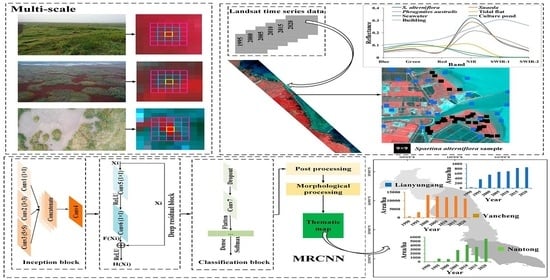
:
1. Introduction
2. Materials
2.1. Study Area
2.2. Data and Pre-Processing
2.3. Field Investigation
3. Methods
3.1. MRCNN Structure
3.2. Unified Training Method Based on MRCNN
4. Results and Analysis
4.1. Testing of the Model
4.2. Temporal and Spatial Distribution of S. alterniflora
4.2.1. Classification of S. alterniflora
4.2.2. Temporal Changes in S. alterniflora
4.2.3. Spatial Changes in S. alterniflora
5. Discussion
5.1. The Relationship between Inception Block and Patch Characteristics
5.2. Expansion Factors of S. alterniflora
5.3. Effects of Mixed Pixels and Tidal Inundation on Classification Results
6. Conclusions
Author Contributions
Funding
Data Availability Statement
Acknowledgments
Conflicts of Interest
References
- Daehler, C.; Strong, D. Hybridization between Introduced Smooth Cordgrass (Spartina alterniflora; Poaceae) and Native California Cordgrass (S. Foliosa) in San Francisco Bay, California, USA. Am. J. Bot. 1997, 84, 607. [Google Scholar] [CrossRef] [PubMed]
- Mao, D.; Liu, M.; Wang, Z.; Li, L.; Man, W.; Jia, M.; Zhang, Y. Rapid Invasion of Spartina alterniflora in the Coastal Zone of Mainland China: Spatiotemporal Patterns and Human Prevention. Sensors 2019, 19, 2308. [Google Scholar] [CrossRef] [PubMed] [Green Version]
- Ren, G.B.; Wang, J.J.; Wang, A.D.; Wang, J.B.; Zhu, Y.L.; Wu, P.Q.; Ma, Y.; Zhang, J. Monitoring the Invasion of Smooth Cordgrass Spartina alterniflora within the Modern Yellow River Delta Using Remote Sensing. J. Coast. Res. 2019, 90, 135–145. [Google Scholar] [CrossRef]
- Zhang, R.S.; Shen, Y.M.; Lu, L.Y.; Yan, S.G.; Wang, Y.H.; Li, J.L.; Zhang, Z.L. Formation of Spartina alterniflora Salt Marshes on the Coast of Jiangsu Province, China. Ecol. Eng. 2004, 23, 95–105. [Google Scholar] [CrossRef]
- An, S.Q.; Gu, B.H.; Zhou, C.F.; Wang, Z.S.; Deng, Z.F.; Zhi, Y.B.; Li, H.L.; Chen, L.; Yu, D.H.; Liu, Y.H. Spartina Invasion in China: Implications for Invasive Species Management and Future Research. Weed Res. 2007, 47, 183–191. [Google Scholar] [CrossRef]
- Li, B.; Liao, C.; Zhang, X.; Chen, H.; Wang, Q.; Chen, Z.; Gan, X.; Wu, J.; Zhao, B.; Ma, Z.; et al. Spartina alterniflora Invasions in the Yangtze River Estuary, China: An Overview of Current Status and Ecosystem Effects. Ecol. Eng. 2009, 35, 511–520. [Google Scholar] [CrossRef]
- Anttila, C.K.; Daehler, C.C.; Rank, N.E.; Strong, D.R. Greater Male Fitness of a Rare Invader (Spartina alterniflora, Poaceae) Threatens a Common Native (Spartina Foliosa) with Hybridization. Am. J. Bot. 1998, 85, 1597–1601. [Google Scholar] [CrossRef]
- Shen, Y.M.; Feng, N.H.; Zhou, Q.; Liu, Y.M.; Chen, Z.Y. The status and its influence of reclamation on Jiangsu coast. Mar. Sci. 2006, 30, 39–43. [Google Scholar]
- Zhu, X.; Meng, L.; Zhang, Y.; Weng, Q.; Morris, J. Tidal and Meteorological Influences on the Growth of Invasive Spartina alterniflora: Evidence from UAV Remote Sensing. Remote Sens. 2019, 11, 1208. [Google Scholar] [CrossRef] [Green Version]
- Deng, Z.; An, S.; Zhou, C.; Wang, Z.; Zhi, Y.; Wang, Y.; Shi, S.; Chen, L.; Zhao, C. Genetic Structure and Habitat Selection of the Tall Form Spartina alterniflora Loisel. in China. Hydrobiologia 2007, 583, 195–204. [Google Scholar] [CrossRef]
- Lu, J.; Zhang, Y. Spatial Distribution of an Invasive Plant Spartina alterniflora and Its Potential as Biofuels in China. Ecol. Eng. 2013, 52, 175–181. [Google Scholar] [CrossRef]
- O’Donnell, J.; Schalles, J. Examination of Abiotic Drivers and Their Influence on Spartina alterniflora Biomass over a Twenty-Eight Year Period Using Landsat 5 TM Satellite Imagery of the Central Georgia Coast. Remote Sens. 2016, 8, 477. [Google Scholar] [CrossRef] [Green Version]
- Bradley, B.A. Remote Detection of Invasive Plants: A Review of Spectral, Textural and Phenological Approaches. Biol. Invasions 2014, 16, 1411–1425. [Google Scholar] [CrossRef]
- Zuo, P.; Zhao, S.; Liu, C.; Wang, C.; Liang, Y. Distribution of Spartina Spp. along China’s Coast. Ecol. Eng. 2012, 40, 160–166. [Google Scholar] [CrossRef]
- Roy, D.P.; Wulder, M.A.; Loveland, T.R.; Woodcock, C.E.; Allen, R.G.; Anderson, M.C.; Helder, D.; Irons, J.R.; Johnson, D.M.; Kennedy, R.; et al. Landsat-8: Science and Product Vision for Terrestrial Global Change Research. Remote Sens. Environ. 2014, 145, 154–172. [Google Scholar] [CrossRef] [Green Version]
- Mahdianpari, M.; Salehi, B.; Mohammadimanesh, F.; Brisco, B.; Mandavi, S.; Amani, M.; Granger, J.E. Fisher Linear Discriminant Analysis of Coherency Matrix for Wetland Classification Using Po1SAR Imagery. Remote Sens. Environ. 2018, 206, 300–317. [Google Scholar] [CrossRef]
- Ren, G.B.; Liu, Y.F.; Ma, Y.; Zhang, J. Spartina alterniflora Monitoring and Change Analysis in Yellow River Delta by Remote Sensing Technology. Acta Laser Biol. Sin. 2014, 23, 596. [Google Scholar]
- Wang, A.; Chen, J.; Jing, C.; Ye, G.; Wu, J.; Huang, Z.; Zhou, C. Monitoring the Invasion of Spartina alterniflora from 1993 to 2014 with Landsat TM and SPOT 6 Satellite Data in Yueqing Bay, China. PLoS ONE 2015, 10, e0135538. [Google Scholar] [CrossRef] [Green Version]
- Ai, J.; Gao, W.; Gao, Z.; Shi, R.; Zhang, C.; Liu, C. Integrating Pan-Sharpening and Classifier Ensemble Techniques to Map an Invasive Plant (Spartina alterniflora) in an Estuarine Wetland Using Landsat 8 Imagery. J. Appl. Remote Sens. 2016, 10, 026001. [Google Scholar] [CrossRef]
- Sun, C.; Liu, Y.; Zhao, S.; Li, H.; Sun, J. Saltmarshes Response to Human Activities on a Prograding Coast Revealed by a Dual-Scale Time-Series Strategy. Estuaries Coasts 2017, 40, 522–539. [Google Scholar] [CrossRef]
- Yang, J.F.; Ma, Y.; Ren, G.B.; Zhang, J.Y.; Fan, Y.G. Monitoring method of invasive vegetation Spartina alterniflora in modern Yellow River delta based on gf remote sensing data. Mar. Environ. Sci. 2017, 36, 596–602. [Google Scholar]
- Hinton, G.E.; Osindero, S.; Teh, Y.W. A Fast Learning Algorithm for Deep Belief Nets. Neural Comput. 2006, 18, 1527–1554. [Google Scholar] [CrossRef] [PubMed]
- Scott, G.J.; England, M.R.; Starms, W.A.; Marcum, R.A.; Davis, C.H. Training Deep Convolutional Neural Networks for Land–Cover Classification of High-Resolution Imagery. IEEE Geosci. Remote Sens. Lett. 2017, 14, 549–553. [Google Scholar] [CrossRef]
- Zhao, W.; Du, S.; Emery, W.J. Object-Based Convolutional Neural Network for High-Resolution Imagery Classification. IEEE J. Sel. Top. Appl. Earth Obs. Remote Sens. 2017, 10, 3386–3396. [Google Scholar] [CrossRef]
- Rezaee, M.; Mahdianpari, M.; Zhang, Y.; Salehi, B. Deep Convolutional Neural Network for Complex Wetland Classification Using Optical Remote Sensing Imagery. IEEE J. Sel. Top. Appl. Earth Observ. Remote Sens. 2018, 11, 3030–3039. [Google Scholar] [CrossRef]
- Rawat, W.; Wang, Z. Deep Convolutional Neural Networks for Image Classification: A Comprehensive Review. Neural Comput. 2017, 29, 2352–2449. [Google Scholar] [CrossRef]
- Zhong, P.; Wang, R.S. Learning Conditional Random Fields for Classification of Hyperspectral Images. IEEE Trans. Image Process. 2010, 19, 1890–1907. [Google Scholar] [CrossRef]
- Marmanis, D.; Schindler, K.; Wegner, J.D.; Galliani, S.; Datcu, M.; Stilla, U. Classification with an Edge: Improving Semantic Image Segmentation with Boundary Detection. ISPRS J. Photogramm. Remote Sens. 2018, 135, 158–172. [Google Scholar] [CrossRef] [Green Version]
- Chen, X.Y.; Xiang, S.M.; Liu, C.L.; Hong, C. Pan Vehicle Detection in Satellite Images by Hybrid Deep Convolutional Neural Networks. IEEE Geosci. Remote Sens. Lett. 2014, 11, 1797–1801. [Google Scholar] [CrossRef]
- Guo, M.; Yu, Z.; Xu, Y.; Huang, Y.; Li, C. ME-Net: A Deep Convolutional Neural Network for Extracting Mangrove Using Sentinel-2A Data. Remote Sens. 2021, 13, 1292. [Google Scholar] [CrossRef]
- Hosseiny, B.; Mahdianpari, M.; Brisco, B.; Mohammadimanesh, F.; Salehi, B. WetNet: A Spatial–Temporal Ensemble Deep Learning Model for Wetland Classification Using Sentinel-1 and Sentinel-2. IEEE Trans. Geosci. Remote Sens. 2022, 60, 4406014. [Google Scholar] [CrossRef]
- Mohammadimanesh, F.; Salehi, B.; Mahdianpari, M.; Gill, E.; Molinier, M. A New Fully Convolutional Neural Network for Semantic Segmentation of Polarimetric SAR Imagery in Complex Land Cover Ecosystem. ISPRS J. Photogramm. Remote Sens. 2019, 151, 223–236. [Google Scholar] [CrossRef]
- Li, H.; Wang, C.; Cui, Y.; Hodgson, M. Mapping Salt Marsh along Coastal South Carolina Using U-Net. ISPRS-J. Photogramm. Remote Sens. 2021, 179, 121–132. [Google Scholar] [CrossRef]
- Chen, M.; Ke, Y.; Bai, J.; Li, P.; Lyu, M.; Gong, Z.; Zhou, D. Monitoring Early Stage Invasion of Exotic Spartina alterniflora Using Deep-Learning Super-Resolution Techniques Based on Multisource High-Resolution Satellite Imagery: A Case Study in the Yellow River Delta, China. Int. J. Appl. Earth Obs. Geoinf. 2020, 92, 102180. [Google Scholar] [CrossRef]
- Tian, J.; Wang, L.; Yin, D.; Li, X.; Diao, C.; Gong, H.; Shi, C.; Menenti, M.; Ge, Y.; Nie, S.; et al. Development of Spectral-Phenological Features for Deep Learning to Understand Spartina alterniflora Invasion. Remote Sens. Environ. 2020, 242, 111745. [Google Scholar] [CrossRef]
- Xiong, Z.; Yuan, Y.; Wang, Q. AI-NET: Attention Inception Neural Networks for Hyperspectral Image Classification. In Proceedings of the IGARSS 2018—2018 IEEE International Geoscience and Remote Sensing Symposium, Valencia, Spain, 22–27 July 2018; pp. 2647–2650. [Google Scholar]
- Li, H.C.; Hu, W.S.; Li, W.; Li, J.; Du, Q.; Plaza, A. A3 CLNN: Spatial, Spectral and Multiscale Attention ConvLSTM Neural Network for Multisource Remote Sensing Data Classification. IEEE Trans. Neural Netw. Learn. Syst. 2022, 33, 747–761. [Google Scholar] [CrossRef]
- Zhu, H.; Ma, M.; Ma, W.; Jiao, L.; Hong, S.; Shen, J.; Hou, B. A Spatial-Channel Progressive Fusion ResNet for Remote Sensing Classification. Inf. Fusion 2021, 70, 72–87. [Google Scholar] [CrossRef]
- Li, G.; Li, L.; Zhu, H.; Liu, X.; Jiao, L. Adaptive Multiscale Deep Fusion Residual Network for Remote Sensing Image Classification. IEEE Trans. Geosci. Remote Sens. 2019, 57, 8506–8521. [Google Scholar] [CrossRef]
- Alotaibi, B.; Alotaibi, M. A Hybrid Deep ResNet and Inception Model for Hyperspectral Image Classification. PFG 2020, 88, 463–476. [Google Scholar] [CrossRef]
- Wang, C.; Wang, G.; Dai, L.; Liu, H.; Li, Y.; Zhou, Y.; Chen, H.; Dong, B.; Lv, S.; Zhao, Y. Diverse Usage of Waterbird Habitats and Spatial Management in Yancheng Coastal Wetlands. Ecol. Indic. 2020, 117, 106583. [Google Scholar] [CrossRef]
- Shen, Y.M.; Zeng, H.; Wang, H.; Liu, Y.M.; Chen, Z.Y. Characteristics of halophyte and associated soil along aggradational muddy coasts in Jiangsu Province. Acta Ecol. Sin. 2005, 25, 1–6. [Google Scholar]
- Shen, Y.M.; Liu, Y.M.; Chen, Q.Z. Analysis of the expanding process of the Spartina alterniflora Loisel salt marsh on Jiangsu Province coast by remote sensing. J. Plant Resour. Environ. 2002, 11, 33–38. [Google Scholar]
- Du, J.; Shi, B.; Li, J.; Wang, Y.P. Muddy Coast Off Jiangsu, China: Physical, Ecological, and Anthropogenic Processes. In Sediment Dynamics of Chinese Muddy Coasts and Estuaries; Elsevier: Amsterdam, The Netherlands, 2019; pp. 25–49. [Google Scholar]
- Ke, C.Q.; Zhang, D.; Wang, F.Q.; Chen, S.X.; Schmullius, C.; Boerner, W.M.; Wang, H. Analyzing Coastal Wetland Change in the Yancheng National Nature Reserve, China. Reg. Environ. Chang. 2011, 11, 161–173. [Google Scholar] [CrossRef]
- Liu, C.Y.; Zhang, S.Q.; Jiang, H.X.; Wang, H. Spatiotemporal dynamics and landscape pattern of alien species Spartina alterniflora in Yancheng coastal wetlands of Jiangsu Province, China. Ying yong sheng tai xue bao = J. Appl. Ecol. 2009, 20, 901–908. [Google Scholar]
- Ouyang, Z.T.; Gao, Y.; Xie, X.; Guo, H.Q.; Zhang, T.T.; Zhao, B. Spectral Discrimination of the Invasive Plant Spartina alterniflora at Multiple Phenological Stages in a Saltmarsh Wetland. PLoS ONE 2013, 8, e67315. [Google Scholar] [CrossRef]
- Gao, Z.G.; Zhang, L.Q. Multi-Seasonal Spectral Characteristics Analysis of Coastal Salt Marsh Vegetation in Shanghai, China. Estuar. Coast. Shelf Sci. 2006, 69, 217–224. [Google Scholar] [CrossRef]
- Thakkar, V.; Tewary, S.; Chakraborty, C. Batch Normalization in Convolutional Neural Networks—A Comparative Study with CIFAR-10 Data. In Proceedings of the 2018 Fifth International Conference on Emerging Applications of Information Technology (EAIT), Kolkata, India, 12–13 January 2018; pp. 1–5. [Google Scholar]
- Li, X.; Li, W.; Xu, X.; Du, Q. CascadeNet: Modified ResNet with Cascade Blocks. In Proceedings of the 2018 24th International Conference on Pattern Recognition (ICPR), Beijing, China, 20–24 August 2018; pp. 483–488. [Google Scholar]
- Xu, X.; Li, W.; Ran, Q.; Du, Q.; Gao, L.; Zhang, B. Multisource Remote Sensing Data Classification Based on Convolutional Neural Network. Ieee Trans. Geosci. Remote Sens. 2018, 56, 937–949. [Google Scholar] [CrossRef]
- Liao, Z.; Carneiro, G. Competitive Multi-Scale Convolution. arXiv 2015, arXiv:1511.05635. [Google Scholar]
- Xu, W.W.; Wang, G.X.; Liu, J.E.; Chen, Z.Y.; Wang, G. Seed characteristics and seedling growth of Spartina alterniflora on coastal wetland of North Jiangsu. Acta Ecol. Sin. 2011, 31, 4560–4567. [Google Scholar]
- Espinar, J.L.; Thompson, K.; Garcia, L.V. Timing of Seed Dispersal Generates a Bimodal Seed Bank Depth Distribution. Am. J. Bot. 2005, 92, 1759–1763. [Google Scholar] [CrossRef] [Green Version]
- Xu, N.; Gong, P. Significant Coastline Changes in China during 1991–2015 Tracked by Landsat Data. Sci. Bull. 2018, 63, 883–886. [Google Scholar]
- Bao, J.; Gao, S.; Ge, J. Dynamic Land Use and Its Policy in Response to Environmental and Social-Economic Changes in China: A Case Study of the Jiangsu Coast (1750–2015). Land Use Policy 2019, 82, 169–180. [Google Scholar] [CrossRef]
- Duan, Y.; Li, X.; Zhang, L.; Liu, W.; Liu, S.; Chen, D.; Ji, H. Detecting Spatiotemporal Changes of Large-Scale Aquaculture Ponds Regions over 1988–2018 in Jiangsu Province, China Using Google Earth Engine. Ocean. Coast. Manag. 2020, 188, 105144. [Google Scholar] [CrossRef]
- Wang, Y.P.; Gao, S.; Jia, J.; Thompson, C.E.L.; Gao, J.; Yang, Y. Sediment Transport over an Accretional Intertidal Flat with Influences of Reclamation, Jiangsu Coast, China. Mar. Geol. 2012, 291–294, 147–161. [Google Scholar]
- Li, L.; Ye, T.; Wang, X.H.; He, Z.; Shao, M. Changes in the Hydrodynamics of Hangzhou Bay Due to Land Reclamation in the Past 60 Years. In Sediment Dynamics of Chinese Muddy Coasts and Estuaries; Elsevier: Amsterdam, The Netherlands, 2019; pp. 77–93. [Google Scholar]
- Feng, L.; Zhu, X.; Sun, X. Assessing Coastal Reclamation Suitability Based on a Fuzzy-AHP Comprehensive Evaluation Framework: A Case Study of Lianyungang, China. Mar. Pollut. Bull. 2014, 89, 102–111. [Google Scholar] [CrossRef]
- Wu, X.W.; Wang, A.J. Impacts of Human Beings’ Activities on North Jiangsu Tidal Flat. Sci. Geogr. Sin. 2005, 25, 614–620. [Google Scholar]
- Deng, Z.F.; An, S.Q.; Zhi, Y.B.; Zhou, C.F.; Chen, L.; Zhao, C.J.; Fang, S.B.; Li, H.L. Preliminary studies on invasive model and outbreak mechanism of exotic species, Spartiona alterniflora Loisel. Acta Ecol. Sin. 2006, 26, 2678–2686. [Google Scholar]
- Mook, W.T.; Chakrabarti, M.H.; Aroua, M.K.; Khan, G.M.A.; Ali, B.S.; Islam, M.S.; Abu Hassan, M.A. Removal of Total Ammonia Nitrogen (TAN), Nitrate and Total Organic Carbon (TOC) from Aquaculture Wastewater Using Electrochemical Technology: A Review. Desalination 2012, 285, 1–13. [Google Scholar] [CrossRef]
- Jasmin, M.Y.; Syukri, F.; Kamarudin, M.S.; Karim, M. Potential of Bioremediation in Treating Aquaculture Sludge: Review Article. Aquaculture 2020, 519, 734905. [Google Scholar]
- Zhang, X.; Xiao, X.; Wang, X.; Xu, X.; Chen, B.; Wang, J.; Ma, J.; Zhao, B.; Li, B. Quantifying Expansion and Removal of Spartina alterniflora on Chongming Island, China, Using Time Series Landsat Images during 1995–2018. Remote Sens. Environ. 2020, 247, 111916. [Google Scholar]
- Wang, J.; Xiao, X.; Qin, Y.; Dong, J.; Geissler, G.; Zhang, G.; Cejda, N.; Alikhani, B.; Doughty, R.B. Mapping the Dynamics of Eastern Redcedar Encroachment into Grasslands during 1984–2010 through PALSAR and Time Series Landsat Images. Remote Sens. Environ. 2017, 190, 233–246. [Google Scholar] [CrossRef] [Green Version]
- Rogers, K.; Lymburner, L.; Salum, R.; Brooke, B.P.; Woodroffe, C.D. Mapping of Mangrove Extent and Zonation Using High and Low Tide Composites of Landsat Data. Hydrobiologia 2017, 803, 49–68. [Google Scholar] [CrossRef]
- Li, S.H.; Ge, Z.M.; Xie, L.N.; Chen, W.; Yuan, L.; Wang, D.Q.; Li, X.Z.; Zhang, L.Q. Ecophysiological Response of Native and Exotic Salt Marsh Vegetation to Waterlogging and Salinity: Implications for the Effects of Sea-Level Rise. Sci. Rep. 2018, 8, 2441. [Google Scholar] [CrossRef] [PubMed]
- Zhang, X.; Xu, J.; Chen, Y.; Xu, K.; Wang, D. Coastal Wetland Classification with GF-3 Polarimetric SAR Imagery by Using Object-Oriented Random Forest Algorithm. Sensors 2021, 21, 3395. [Google Scholar] [CrossRef]
- Adeli, S.; Salehi, B.; Mahdianpari, M.; Quackenbush, L.J.; Brisco, B.; Tamiminia, H.; Shaw, S. Wetland Monitoring Using SAR Data: A Meta-Analysis and Comprehensive Review. Remote Sens. 2020, 12, 2190. [Google Scholar] [CrossRef]


| Period | Sensor | Imaging Time | Resolution (m) | Number of Bands |
|---|---|---|---|---|
| 1990 | Landsat 5 TM | 10/21/1989 | 30 | 6 |
| 10/30/1989 | ||||
| 10/31/1990 | ||||
| 1995 | Landsat 5 TM | 08/03/1995 | 30 | 6 |
| 08/12/1995 | ||||
| 09/27/1995 | ||||
| 2000 | Landsat 5 TM | 08/21/2000 | 30 | 6 |
| 09/17/2000 | ||||
| 10/10/2000 | ||||
| 2005 | Landsat 5 TM | 08/20/2004 | 30 | 6 |
| 10/08/2005 | ||||
| 10/17/2005 | ||||
| 2010 | Landsat 5 TM | 09/19/2009 | 30 | 6 |
| 10/03/2009 | ||||
| 10/31/2010 | ||||
| 2015 | Landsat 8 OLI | 08/03/2015 | 30 | 6 |
| 09/18/2015 | ||||
| 10/13/2015 | ||||
| 2020 | Landsat 8 OLI | 10/31/2019 | 30 | 6 |
| 08/16/2020 | ||||
| 09/08/2020 |
| Period | Number of S. alterniflora Samples | Number of Background Samples | Total |
|---|---|---|---|
| 1995 | 349 | 3490 | 3839 |
| 2000 | 1195 | 11,950 | 13,145 |
| 2005 | 1325 | 13,250 | 14,575 |
| 2010 | 1393 | 13,930 | 15,323 |
| 2015 | 1416 | 14,160 | 15,576 |
| 2020 | 1453 | 14,530 | 15,983 |
| Total | 7131 | 71,310 | 78,441 |
| Period | Number of S. alterniflora Samples | Number of Background Samples | Total |
|---|---|---|---|
| 1995 | 233 | 312,294 | 312,527 |
| 2000 | 797 | 302,425 | 303,222 |
| 2005 | 884 | 300,908 | 301,792 |
| 2010 | 929 | 300,115 | 301,044 |
| 2015 | 945 | 299,846 | 300,791 |
| 2020 | 969 | 299,415 | 300,384 |
| Period | Method | Accuracy | Recall | Precision | F1-Score |
|---|---|---|---|---|---|
| 1995 | CascadeNet | 99.94 | 99.45 | 37.57 | 54.54 |
| Dual-tunnel CNN | 99.95 | 99.61 | 38.94 | 55.99 | |
| MRCNN | 99.95 | 99.68 | 41.99 | 59.09 | |
| 2000 | CascadeNet | 99.63 | 97.43 | 23.58 | 37.97 |
| Dual-tunnel CNN | 99.75 | 96.95 | 31.54 | 47.59 | |
| MRCNN | 99.70 | 98.35 | 27.68 | 43.20 | |
| 2005 | CascadeNet | 99.78 | 98.45 | 35.31 | 51.98 |
| Dual-tunnel CNN | 99.69 | 98.74 | 28.05 | 43.69 | |
| MRCNN | 99.82 | 95.97 | 40.99 | 57.45 | |
| 2010 | CascadeNet | 99.61 | 97.79 | 26.84 | 42.12 |
| Dual-tunnel CNN | 99.60 | 98.38 | 26.42 | 41.65 | |
| MRCNN | 99.70 | 98.44 | 31.84 | 48.12 | |
| 2015 | CascadeNet | 99.62 | 97.60 | 29.11 | 44.84 |
| Dual-tunnel CNN | 99.42 | 98.75 | 21.33 | 35.08 | |
| MRCNN | 99.62 | 97.42 | 28.95 | 44.64 | |
| 2020 | CascadeNet | 99.76 | 97.62 | 39.83 | 56.58 |
| Dual-tunnel CNN | 99.64 | 98.82 | 31.23 | 47.46 | |
| MRCNN | 99.78 | 97.94 | 42.07 | 58.86 |
| Period | Method | Precision | F1-Score |
|---|---|---|---|
| 1995 | MRCNN + Post Processing | 70.23 | 82.40 |
| 2000 | MRCNN + Post Processing | 69.33 | 81.32 |
| 2005 | MRCNN + Post Processing | 73.67 | 83.35 |
| 2010 | MRCNN + Post Processing | 68.28 | 80.63 |
| 2015 | MRCNN + Post Processing | 76.55 | 85.73 |
| 2020 | MRCNN + Post Processing | 75.68 | 85.38 |
Publisher’s Note: MDPI stays neutral with regard to jurisdictional claims in published maps and institutional affiliations. |
© 2022 by the authors. Licensee MDPI, Basel, Switzerland. This article is an open access article distributed under the terms and conditions of the Creative Commons Attribution (CC BY) license (https://creativecommons.org/licenses/by/4.0/).
Share and Cite
Zhu, W.; Ren, G.; Wang, J.; Wang, J.; Hu, Y.; Lin, Z.; Li, W.; Zhao, Y.; Li, S.; Wang, N. Monitoring the Invasive Plant Spartina alterniflora in Jiangsu Coastal Wetland Using MRCNN and Long-Time Series Landsat Data. Remote Sens. 2022, 14, 2630. https://0-doi-org.brum.beds.ac.uk/10.3390/rs14112630
Zhu W, Ren G, Wang J, Wang J, Hu Y, Lin Z, Li W, Zhao Y, Li S, Wang N. Monitoring the Invasive Plant Spartina alterniflora in Jiangsu Coastal Wetland Using MRCNN and Long-Time Series Landsat Data. Remote Sensing. 2022; 14(11):2630. https://0-doi-org.brum.beds.ac.uk/10.3390/rs14112630
Chicago/Turabian StyleZhu, Wenqing, Guangbo Ren, Jianping Wang, Jianbu Wang, Yabin Hu, Zhaoyang Lin, Wei Li, Yajie Zhao, Shibao Li, and Ning Wang. 2022. "Monitoring the Invasive Plant Spartina alterniflora in Jiangsu Coastal Wetland Using MRCNN and Long-Time Series Landsat Data" Remote Sensing 14, no. 11: 2630. https://0-doi-org.brum.beds.ac.uk/10.3390/rs14112630