
Reconstruction of Rainfall Field Using Earth–Space Links Network: A Compressed Sensing Approach

1
College of Meteorology and Oceanography, National University of Defense Technology, Changsha 410073, China
2
Beijing Institute of Applied Meteorology, Beijing 100029, China
*
Author to whom correspondence should be addressed.
Remote Sens. 2022, 14(19), 4966; https://0-doi-org.brum.beds.ac.uk/10.3390/rs14194966
Submission received: 29 August 2022
/
Revised: 26 September 2022
/
Accepted: 30 September 2022
/
Published: 6 October 2022
(This article belongs to the Special Issue Synergetic Remote Sensing of Clouds and Precipitation)
Abstract
:High-precision rainfall information is of great importance for the improvement of the accuracy of numerical weather prediction and the monitoring of floods and mudslides that affect human life. With the rapid development of satellite constellation networks, there is great potential for reconstructing high-precision rainfall fields in large areas by using widely distributed Earth–space link (ESL) networks. In this paper, we have carried out research on reconstructing high-precision rainfall fields using an ESL network with the compressed sensing (CS) method in the case of a sparse distribution of the ESLs. Firstly, ESL networks with different densities are designed using the K-means clustering algorithm. The real rainfall fields are then reconstructed using the designed ESL networks with CS, and the reconstructed results are compared with that of the inverse distance weighting (IDW) algorithm. The results show that the root mean square error (RMSE) and correlation coefficient (CC) of the reconstructed rainfall fields using the ESL network with CS are lower than 0.15 mm/h and higher than 0.999, respectively, when the density is 0.05 links per square kilometer, indicating that the ESL network with CS is capable of reconstructing the high-precision rainfall fields under sparse sampling. Additionally, the performance of reconstructing the rainfall fields using the ESL networks with CS is superior compared to the reconstructed results of the IDW algorithm.
1. Introduction
High-resolution measurement of rainfall is of great importance for the monitoring and warning of natural disasters such as floods and mudslides [1]. Moreover, high-precision rainfall data play an important role in improving the accuracy of numerical weather prediction [2]. At present, the traditional instruments used to obtain rainfall information mainly include rain gauges, weather radars and meteorological rainfall measuring satellites [3]. The rainfall obtained by a rain gauge only represents the rainfall at the location of the weather station due to the non-uniform spatial and temporal distribution of the rainfall [4,5]. Weather radar is the primary instrument for ground-based remote sensing of precipitation and plays an important role in the monitoring and warning of extreme rainfall [6]. Additionally, rainfall measuring satellites are capable of global monitoring of widespread precipitation, such as the TRMM (Tropical Rainfall Measuring Mission) and the GPM (Global Precipitation Measurement) mission, but the resolution of rainfall detected by rainfall measuring satellites is very low, and the cost is enormous [7]. The combined use of these traditional instruments has great potential for high-precision detection of rainfall. However, traditional instruments for rainfall detection are unevenly distributed all over the world, especially in remote areas with more sparse density distribution [8]. Therefore, it is of great importance to develop new techniques for detecting rainfall with low cost and high resolution for high-precision detection of rainfall.
In recent years, a new method of measuring rainfall using microwave links to retrieve rainfall has been proposed based on the physical phenomenon that a microwave signal is attenuated as it propagates through rainfall [9]. In addition, the use of microwave links to retrieve rainfall data has the advantage of low cost and high resolution compared to the traditional rainfall measuring instruments, as it relies on the widespread distribution of existing communication base stations. Furthermore, the method has been validated for applications such as precipitation classification, radar parameter correction and raindrop size distribution (DSD) inversion [10,11]. Additionally, the dense distribution of communication base stations has provided the basic conditions for using microwave link networks to retrieve data on large rainfall fields in an area with the development of new-generation communication technologies. Zinevich et al. [12] and Goldshtein et al. [13] implemented the reconstruction of a rainfall field using a horizontal microwave link network based on inverse distance weighting (IDW) and computer tomography (CT) techniques, respectively, further validating the feasibility of the scheme. However, currently available microwave links, limited by sparse density and irregular topology, are still not capable of supporting IDW and CT algorithms to reconstruct high-precision rainfall fields.
In addition to horizontal microwave links between ground-based communication base stations, the method of retrieving rainfall data using the inclined Earth–space links (ESL) between communication satellites in space and ground-based receiving antennas has also attracted widespread interest since its proposed introduction, and has been validated by a number of intensive studies [14,15,16]. The research was first initiated with the retrieval of rain rate and accumulated rainfall by a single ESL in the Ku band and Ka band, and the key to that was to accurately extract the rain attenuation from the combined attenuation of the ESL signal caused by multiple factors in the atmosphere [15,17]. It has been shown that the attenuation caused by light rain is not significant for an ESL in the Ku band, and thus the retrieval results for light rainfall are poor [14,18]. A corresponding ESL in the Ka band is better for retrieval of light rainfall because the microwave signal is more affected by the rainfall at higher frequencies, but it is also important not to ignore the effect of other factors in the atmosphere [15]. Furthermore, a large number of communication satellites are forming networks above the Earth with the rapid development of the satellite Internet of Things, such as the Starlink satellite constellation of SpaceX, which provides the opportunity to use multiple ESL de-networks to reconstruct the high-precision rainfall fields in the area [19,20,21,22,23]. In terms of the research on reconstructing rainfall fields with ESL networks, it is crucial to find an algorithm that enables the reconstruction of a rainfall field with high accuracy based on the actual distribution of ESL networks. Moreover, the CT technique, the IDW algorithm and Kriging interpolation have been successively used to reconstruct rainfall fields using multiple ESLs as verified by simulation experiments [19,20,23]. The results of these studies validate the feasibility of reconstructing rainfall fields by ESL networks and further demonstrate the great potential of the method for monitoring rainfall over large areas.
Previous studies on reconstructing rainfall fields using multiple ESLs are mainly theoretical validations based on simulations and have not considered the effect of the density and structural distribution of the actual ESL [20,23]. Moreover, the use of general spatial interpolation algorithms (e.g., IDW and Kriging interpolation) and CT techniques to reconstruct rainfall fields has high requirements regarding the density and topology of the links network. As a matter of fact, the distribution of satellite antennas on the ground, the sparsity of the links and the accuracy of the reconstruction results are all important and need to be taken into account when reconstructing rainfall fields using ESL networks. In view of the superior spatial reconstruction performance of the compressed sensing (CS) method in other fields in the case of sparse sampling [24,25], we propose the use of CS to reconstruct high-precision rainfall fields based on the sparse density distribution of the ESL network in this paper. Firstly, the ESL networks with different densities conforming to the CS principle have been designed in Jiangning district, Nanjing, based on the spatial clustering algorithm. The real rainfall fields in the area are then reconstructed using the ESL networks with CS, and the reconstructed results are compared with those of the IDW algorithm, so as to validate the performance of the method. The major contributions in this article are as follows:
- (1)
- The spatial clustering algorithm has been used to design the ESL network conforming to the CS principle, and the effect of the distribution of ESL on reconstructing the rainfall fields has been studied.
- (2)
- The CS technique has been used for reconstructing rainfall fields using an ESL network, and the results show that an ESL network with CS is able to reconstruct high-precision rainfall fields under sparse sampling.
The rest of this paper is organized as follows. Section 2 describes the principles of retrieving rainfall by ESL and the methods for reconstructing rainfall fields using the ESL network with CS. Section 3 provides a simulated design for the ESL networks. The performance of reconstructing the real rainfall fields using the designed ESL networks with CS is presented in Section 4. Finally, the conclusions to the paper are given in Section 5.
2. Principles of Reconstructing Rainfall Field
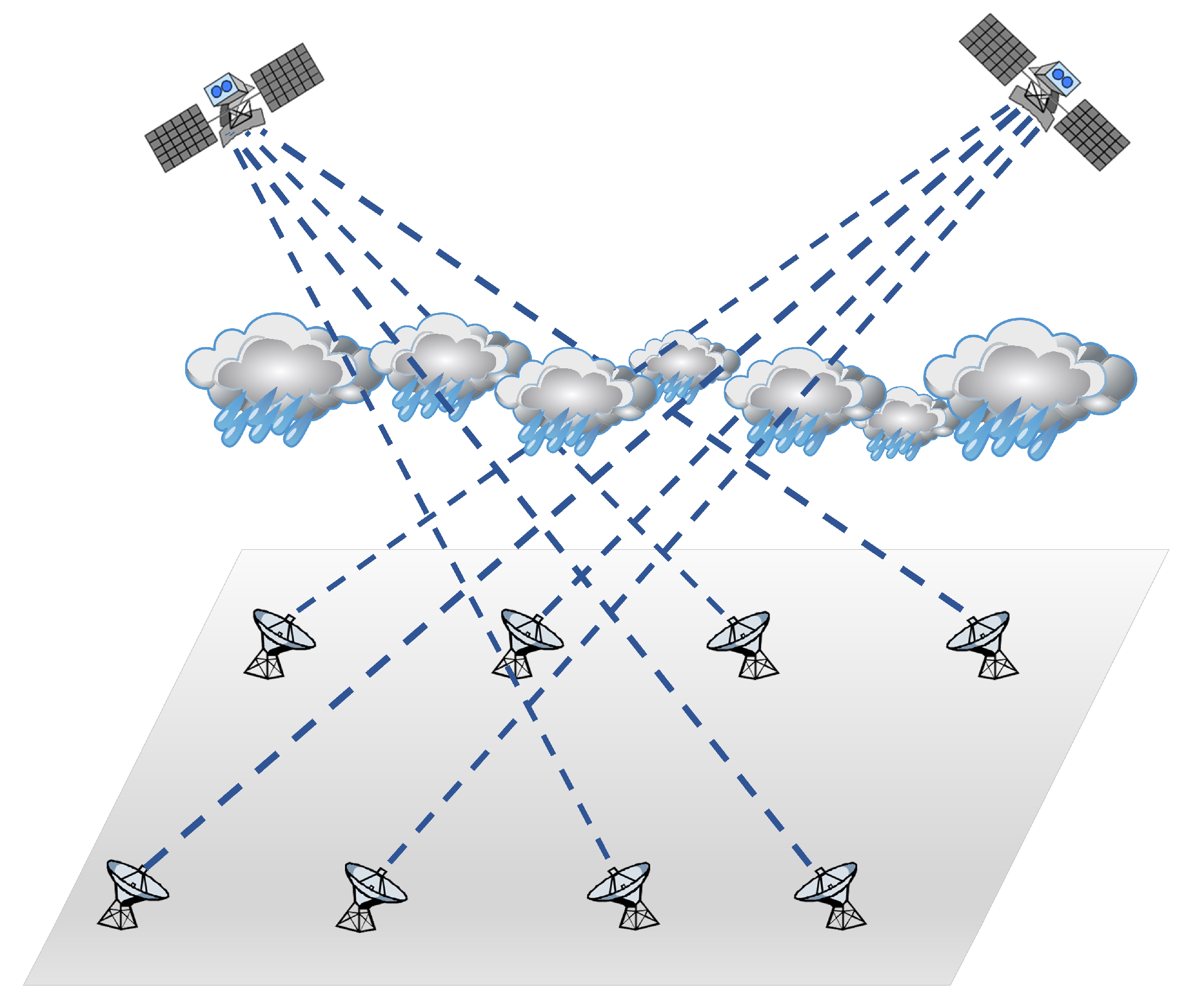
When rainfall happens in the atmosphere, microwave communication signals will be significantly attenuated by the effect of scattering and absorption caused by raindrops, and rainfall is the most major meteorological factor affecting the quality of microwave communication signals. The cleverness of using ESL to retrieve rainfall is that it transforms the interference of rain attenuation in the communications field into a favorable condition for obtaining atmospheric parameters in the meteorological field. The rainfall retrieved by a single ESL represents the average rainfall at the location of the link. Furthermore, when there are multiple ESLs forming an ESL network, it can be used to retrieve the distribution of the sparse rainfall in the area and then reconstruct the rainfall field in the area through a reconstruction algorithm.
2.1. Description of Rainfall Retrieved by ESL
The total attenuation of an ESL caused by rainfall can be considered as the cumulative effect of the attenuation of all raindrops appearing in the path of the ESL. As a result, the rain attenuation coefficient γR (dB/km) can be expressed as [17,18]
where D denotes the equivalent diameter of the raindrop, Cext(D) is the extinction cross section of the raindrop, and N(D) is the DSD. Furthermore, based on extensive experimental verification [26,27], Equation (1) can be abbreviated as
where R (mm/h) is the average rain rate along the path, and the coefficients α and β can be obtained from ITU-R P.838-3 [27]. When the length of the ESL in the rainfall area is LR (km), the rain attenuation AR (dB) can be obtained by
where h0 is the height of the atmospheric 0 ℃-Layer [28], and θ is the elevation angle of the antenna.
In order to obtain the rain attenuation caused by rainfall to an ESL, the signal-to-noise ratio (SNR) when there is no rainfall is considered as the attenuation baseline when the ESL signal is recorded in real time using the receiver; the rain attenuation can then be obtained by the SNR when there is rainfall and the SNR when there is no rainfall, denoted as SNRno-rain and SNRrain, respectively, and written as
Thus, combining Equations (2)–(4) allows the average rain rate retrieved by ESL to be written as
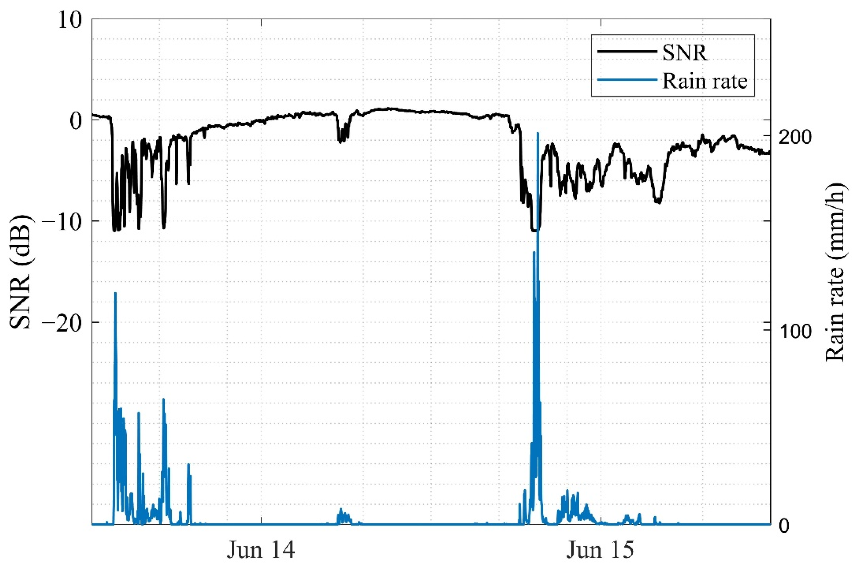
To further investigate the correlation between the SNR of the ESL signal and the actual rain rate, we recorded the variation process of the ESL signal during rainfall using the ESL at the Ku band in Jiangning district, Nanjing. The variation process of the ESL signal with the rain rate during a rainfall event in June 2020 is shown in Figure 1. It is found that the SNR of the ESL signal decreases significantly when rainfall occurs. Moreover, the signal also produces small fluctuations during non-rainfall periods, which are mainly caused by noise. Further calculation has shown that the correlation coefficient (CC) between the SNR of the ESL signal and the rain rate is −0.714. This indicates that there is a strong negative correlation between the two and that the relationship is the essential mechanism for retrieving rainfall data using the ESL. In our previous work [18], we carried out research on rainfall retrieval using a single ESL, which provides the basis for reconstructing rainfall fields using a network of multiple ESLs.
2.2. Algorithm for Reconstructing Rainfall Field by ESL Network
When there are multiple ESLs in the area as shown in Figure 2, the rain rates at the locations of all these ESLs can be obtained. As the rain rates at these different locations represent the distribution of parts of the rainfall field over the whole area, a reconstruction algorithm can be used to reconstruct the complete rainfall field. However, the actual density of the ground antennas of the ESLs is very sparse, which makes the number of ESLs much smaller than the scale required for the refinement of the rainfall field. In this case, the system of equations for reconstructing the rainfall field using an ESL network is underdetermined, and it is difficult to obtain a high-precision rainfall field by ordinary spatial interpolation algorithms. To solve this problem, the CS theory with certain a priori information is proposed to realize reconstructing the high-precision rainfall field in the area using the ESL network in the case of sparse sampling.
The core of reconstructing the rainfall field using the ESL network is how to reconstruct the complete rainfall field in the area from sparsely distributed rainfall information measured by the ESL network, and the process can be represented as
where x is the rain attenuation at the locations of the links measured by the ESL network, f denotes the rainfall field, and A is the measurement matrix that is determined by the structural and density distribution of the ground antennas of the ESL network in the area. In fact, the amount of links m that form the ESL network is generally much smaller than the scale of the rainfall field n. Therefore, the complete rainfall field is not directly obtained from the sparse rainfall information measured by the ESL network. However, according to the CS theory [29], if f has sparse properties under certain conditions and can be represented by a sparse vector, then f can be solved by using x based on the CS method. The sparse representation of f is given by
where s is the sparse signal of f, and ψ is the sparse basis of f.
Previous studies have shown that various types of signals have good sparsity under a redundant dictionary that is an adaptive sparse basis representation [29,30]. Therefore, we use a redundant dictionary based on the K-singular value decomposition (K-SVD) method [30] for the sparse representation of the rainfall field f. As for the solution of the redundancy dictionary, it is a process of establishing the prior relationship between the rainfall field f and the sparse signal s, and the mathematical model is given by
where D is the redundancy dictionary, ε0 is the constant, and ‖si‖0 is the l0 norm which refers to the number of non-zero vectors in s. In order to solve Equation (10), it is converted into an unconstrained mathematical model with the Lagrange multiplier λ, and ‖si‖0 is replaced by ‖si‖1, resulting in
The redundant dictionary is then updated column by column using the iterative method, in which the j-th column vector is calculated as
where dj is the j-th column vector of the redundant dictionary D, sj is the j-th row vector of the sparse signal s, and Ef is the residual. Furthermore, the singular value decomposition (SVD) is used to express Ef in Equation (10) as
where U is the left singular matrix, V is the right singular matrix, and ∑ is the diagonal matrix of singular values. Next, the redundant dictionary and the sparse signal are obtained by
Therefore, after representing the sparse basis using the redundant dictionary based on the K-SVD method, the rainfall field reconstruction based on the CS method can be given by Equations (6) and (7) as
where θ refers to the sensing matrix. Additionally, to ensure the convergence of the reconstructed rainfall field results, the sensing matrix is required to conform to the restricted isometry property (RIP) [31], as given by
where δ is the smallest constant that makes the RIP hold. In general, the RIP is equivalently represented by the coherence of the sensing matrix, which is defined as the maximum absolute value of the inner product of any two column vectors of the sensing matrix, and is denoted by
where C(θ) is the coherence of the sensing matrix, and θi and θj are any two column vectors of the sensing matrix. The coherence of the sensing matrix is mainly used to determine the suitability of using the CS method to reconstruct the rainfall field. Moreover, the smaller the coherence of the sensing matrix, the better the performance of the CS method for reconstructing the rainfall field. Additionally, according to the CS theory, the premise of reconstructing the complete rainfall field using the CS method is that the coherence of the sensing matrix has to conform to
The lower bound in the above equation is the celebrated Welch boundary [32].
When the actual rainfall field is sparse and the sensing matrix conforms to the RIP, the optimal model of CS can be used to implement the solution for the sparse signal s [29]. This computational model is given by
Here we use basis pursuit (BP) algorithm to solve for s in Equation (13), and then the rainfall field can be reconstructed using a redundant dictionary of real rainfall fields.
3. Design of the ESL Network
To verify the feasibility and performance of reconstructing high-precision rainfall fields using an ESL network with CS, we have carried out the design of an ESL network by simulation experiment in Jiangning district, Nanjing. The range of the experimental area is 118.4808° E–119.1178° E, 31.6235° N–32.1165° N. The whole experimental area of approximately 1581 km2 is divided into 1581 grids, and the rainfall distribution within each grid is considered to be uniform, so that the spatial resolution of the rainfall fields in the area is 1 × 1 km2. In addition, the average height of the atmospheric 0 °C layer in the area is approximately 4.67 km [28].
The ESL network designed is capable of detecting the sparsely distributed rainfall information in the area, and the design of the ESL network directly affects the accuracy of the reconstructed rainfall fields. Additionally, the actual distribution of the ground antennas of the ESL in the area can generally be regarded as a randomly distribution. Therefore, in order to make the rainfall information detected by the designed ESL network as representative of the entire regional rainfall field as possible, we used the K-means clustering algorithm to make the links that form the ESL network distributed uniformly and randomly in the area [33]. The detailed process of the algorithm for designing the ESL network is as follows:
- (1)
- Randomly select m points from the n grid points in the experimental area as the initial locations of the antennas of the ESL network.
- (2)
- Calculate the distance from all grid points of the area to each antenna position of the ESL network, and divide the area into m classes based on the rule of the shortest distance.
- (3)
- The mean value of the area for each class is calculated and used as the center of the new clusters.
- (4)
- Repeat steps (2) and (3) until the clustering results no longer change. Following that, m points in the area are used as locations for the antennas of the ESL network, from which the designed ESL network can be obtained.
It should be noted that the K-means clustering algorithm is used here to create ESL networks with different densities and structures uniformly distributed, and in practice the networking needs to consider the effect of topography. Additionally, in order to make the sensing matrix determined by the ESL network conform to RIP under CS theory, the number of links m that form the ESL network needs to conform to the qualification that is given by [29]
where k is the sparsity of the sparse signal, and C is the constant. With the sparsity k being set to 10, it is calculated that m ≥ 19.493. Therefore, we designed four types of ESL network, with the number of links being 20, 40, 60 and 80, respectively, in the experimental area based on the K-means clustering algorithm, and we named them ESL network 1, ESL network 2, ESL network 3 and ESL network 4 in order, as shown in Figure 3. Additionally, the antennas of the ESL networks receive the horizontally polarized signal of ChinaSat10 at 12.63 GHz, and the Gaussian noise is used to simulate the systematic noise of each link of the ESL networks.
4. Results and Discussion
Firstly, we used the designed ESL networks to obtain the sparse distribution of rain rates in the area. The CS method was then used to reconstruct the sparse rain rates to obtain a continuously distributed rainfall field in the area. To verify the feasibility and performance of reconstructing the rainfall fields using the ESL networks with CS, we used the rainfall products of the Climate Prediction Center Morphing Technique (CMORPH) published by the National Oceanic and Atmospheric Administration (NOAA) to establish the real rainfall fields in the area, and we then reconstructed the real rainfall fields of CMORPH using the ESL networks with CS. Because the experimental area was gridded to 1 km, we used the spatial interpolation algorithm to process the resolution of the rainfall fields of CMORPH from 8 × 8 km2 to 1 × 1 km2, so as to ensure the spatial resolution of the rainfall fields in the area was 1 × 1 km2.
To further illustrate the performance of the CS method for reconstructing rainfall fields, the results of the reconstruction of rainfall fields by the CS method are compared with the reconstruction results of the IDW algorithm. Additionally, the root mean square error (RMSE), the mean bias (MB) and the correlation coefficient (CC) are used to quantitatively evaluate the error, unbiasedness and correlation between the reconstructed rainfall fields and the real rainfall fields, respectively [22]. These quantitatively evaluated indicators are given by
and
where cov(R′, Rreal) is the covariance between the reconstructed rainfall field R′ and the real rainfall field Rreal, and σR′ and σRreal are the standard deviations of the reconstructed rainfall field and the real rainfall field, respectively.
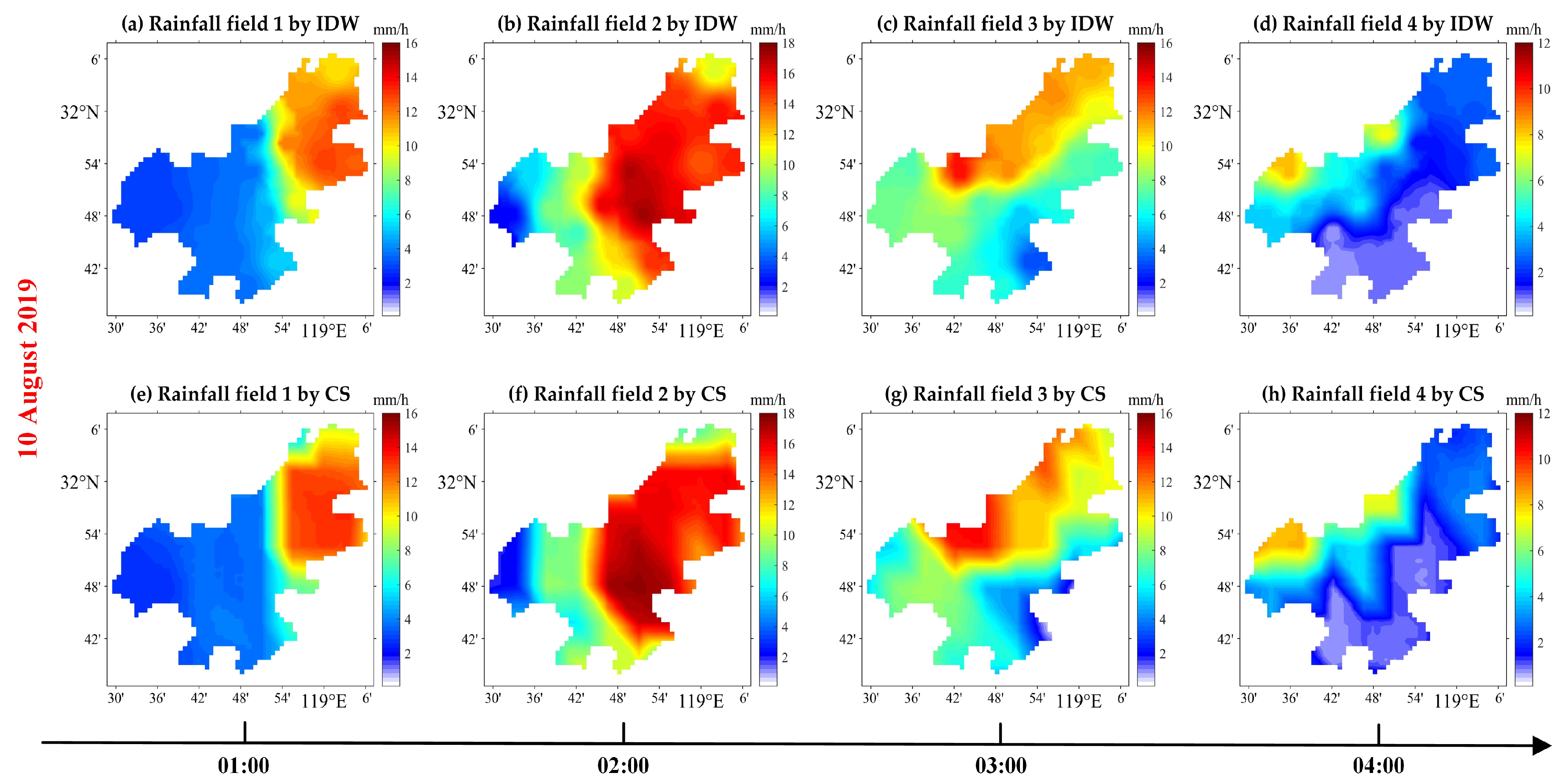
To verify the feasibility of reconstructing a real rainfall field using an ESL network, a rainfall event on 10 August 2019 was reconstructed using the designed ESL network 1, which has the minimum number of links. Rainfall field 1 to rainfall field 4 depict the development of the rainfall event from 01:00 to 04:00 with intervals of one hour in Figure 4. The rainfall fields of the rainfall event were then reconstructed using ESL network 1, and the results are shown in Figure 5 and Figure 6 for the cases of no noise and systematic noise, respectively. By simple comparison of Figure 4 and Figure 5, it can be found that the systematic noise has essentially no significant effect on the reconstruction results of the IDW algorithm, while there is a slight effect on the reconstruction results of the CS method. Additionally, by comparing the real rainfall fields in Figure 4 with the reconstructed rainfall fields in Figure 5 and Figure 6, it can be shown that both the IDW algorithm and CS have the capacity to reconstruct the basic distribution characteristics of the rain rates of the rainfall fields and to accurately monitor the movement of the rain cluster from southeast to northwest in that rainfall process. However, there are significant local distortions in the rainfall fields reconstructed by the IDW algorithm which reflect the local differences between the reconstructed rainfall fields and the real rainfall fields in terms of the structure. On the whole, the consistency between the rainfall fields reconstructed by CS and the real rainfall fields in terms of structural distribution is better than that of the IDW algorithm.
The results of the quantitative evaluation with RMSE, MB and CC of using ESL network 1 to reconstruct the real rainfall fields of that rainfall event are given in Table 1. It can be seen that the MB of the rainfall fields reconstructed using ESL network 1 are essentially unbiased except for the fact that the IDW algorithm underestimates the rainfall fields 4. By comparing the quantitative reconstruction results in the case of no noise and with systematic noise, it can be found that systematic noise, which follows the normal distribution, has essentially no effect on the reconstruction results of the IDW algorithm, while the accuracy of the reconstruction results of the CS method is decreased. Additionally, when considering systematic noise, the RMSE and CC of the rainfall fields reconstructed by the IDW algorithm are lower than 1.21 mm/h and higher than 0.934, respectively, and the RMSE and CC of the results reconstructed by CS are lower than 0.25 mm/h and higher than 0.997, respectively. Therefore, the performance of reconstructing the rainfall fields by CS is better than that of the IDW algorithm in terms of reconstructing the rainfall fields of the individual rainfall event both without and with systematic noise.
To further examine the performance of the ESL networks in reconstructing the rainfall fields, the four designed ESL networks have been used to reconstruct the rainfall fields from May to September each year during the period of 2017 to 2019 in Jiangning district, Nanjing, considering systematic noise. Figure 7 shows the results of the four designed ESL networks reconstructing the rain rates of all rainfall fields. The MB of the results of the four ESL networks reconstructing the rainfall fields shows that the rain rates of the rainfall fields reconstructed by the IDW algorithm and the CS method are essentially unbiased regarding the rain rates of the real rainfall fields, which means that the two reconstruction methods both do not overestimate or underestimate the rainfall fields. Additionally, the accuracy of reconstructing the rainfall fields by the IDW algorithm and CS improves sequentially as the density of the links in the ESL network increases, and the performance of reconstructing the rainfall fields using the four ESL networks with the CS method is superior to the results of the IDW algorithm. Moreover, the reconstructed rainfall fields using an ESL network with CS have been closely approximated to the real rainfall fields when the number of links in the ESL network increases from 20 to 80 in the experimental area of almost 1581 km2. Specifically, the RMSE and CC of the reconstructed rainfall fields using ESL network 4 with a link density of 0.05 links per square kilometer are lower than 0.15 mm/h and higher than 0.999, respectively. This illustrates that an ESL network with CS is capable of reconstructing high-precision rainfall fields under sparse sampling.
5. Conclusions
In this paper, we have carried out research on reconstructing high-precision rainfall fields using an ESL network with CS in the case of the sparse distribution of the ESLs. First of all, ESL networks with different densities were designed using the K-means clustering algorithm in Jiangning district, Nanjing. We then used the designed ESL networks with the CS method to reconstruct the real rainfall fields from the CMORPH and compared the reconstructed results with those of the IDW algorithm. The results show the feasibility of reconstructing rainfall fields using an ESL network, and the performance of reconstructing rainfall fields using the ESL networks with CS is better than that of the IDW algorithm both without and with systematic noise. When the density is 0.05 links per square kilometer, the RMSE and CC of the rainfall fields reconstructed using the ESL network with CS are lower than 0.15 mm/h and higher than 0.999, respectively. It is thus further illustrated that an ESL network with CS is capable of reconstructing high-precision rainfall fields under sparse sampling.
With the development of satellite constellation communication networks, there is great potential to reconstruct rainfall fields with high precision in large areas by using widely distributed ESL networks. We have only preliminarily verified the feasibility of reconstructing the high-precision rainfall fields using ESL networks with CS through the simulation. Additionally, when reconstructing rainfall fields using the CS method, the prior relationship between the rainfall fields and the sparse signal has to be established first by using a redundant dictionary, which requires sufficient historical data and consumes some computational cost in advance. Also, the same process needs to be carried out for different areas. However, the high-precision reconstruction performance of the CS method under sparse sampling makes it still worthwhile to investigate the method in more depth. Next, we will build a real ESL network and reconstruct the high-precision rainfall fields in the area of the network. Furthermore, the ESL network will be exploited to monitor the rainfall information in the area on a large scale.
Author Contributions
Conceptualization, Y.Z. and X.L.; methodology, Y.Z. and X.L.; software, Y.Z. and K.S.; validation, L.L. and K.P.; formal analysis, X.L. and L.L.; investigation, X.L. and K.P.; resources, Y.Z. and K.S.; data curation, Y.Z. and X.L.; writing—original draft preparation, Y.Z.; writing—review and editing, X.L. and K.P.; visualization, Y.Z. and L.L.; supervision, X.L.; project administration, X.L.; funding acquisition, X.L. All authors have read and agreed to the published version of the manuscript.
Funding
This research was funded by the National Natural Science Foundation of China (Grant No. 41975030), and the Excellent Youth Scholars of Natural Science Foundation of Hunan Province of China (Grant No. 2021JJ20046).
Data Availability Statement
The data used in the simulation experiment on rainfall fields retrieved are provided by Climate Prediction Center of NOAA, which can be download from an open-access source: https://ftp.cpc.ncep.noaa.gov/precip/CMORPH_V1.0/ (accessed on 22 January 2021). Additionally, the data used in this study can be obtained from the corresponding author of this article.
Acknowledgments
The authors thank the editor and anonymous reviewers for providing helpful advice.
Conflicts of Interest
The authors declare no conflict of interest.
References
- Abbot, C. Precipitation Cycles. Science 1949, 110, 148. [Google Scholar] [CrossRef] [PubMed]
- Alpert, P.; Rubin, Y. First Daily Mapping of Surface Moisture from Cellular Network Data and Comparison with Both Observations/ECMWF Product. Geophys. Res. Lett. 2018, 45, 8619–8628. [Google Scholar] [CrossRef]
- McCabe, M.F.; Rodell, M.; Alsdorf, D.E.; Miralles, D.G.; Uijlenhoet, R.; Wagner, W.; Lucieer, A.; Houborg, R.; Verhoest, N.E.C.; Franz, T.E.; et al. The Future of Earth Observation in Hydrology. Hydrol. Earth Syst. Sci. 2017, 21, 3879–3914. [Google Scholar] [CrossRef] [PubMed] [Green Version]
- Blandine, B.; Rieckermann, J.; Berne, A. Quality control of rain gauge measurements using telecommunication microwave links. J. Hydrol. 2013, 492, 15–23. [Google Scholar]
- Liu, X.C.; Gao, T.C.; Liu, L. A comparison of rainfall measurements from multiple instruments. Atmos. Meas. Tech. 2013, 6, 1585–1595. [Google Scholar] [CrossRef] [Green Version]
- Matrosov, S. Dual-frequency radar ratio of nonspherical atmospheric hydrometeors. Geophys. Res. Lett. 2005, 32, L13816. [Google Scholar] [CrossRef] [Green Version]
- Getirana, A.; Kirschbaum, D.B.; Mandarino, F.; Ottoni, M.; Arsenault, K. Potential of GPM IMERG Precipitation Estimates to Monitor Natural Disaster Triggers in Urban Areas: The Case of Rio de Janeiro, Brazil. Remote Sens. 2020, 12, 4095. [Google Scholar] [CrossRef]
- Tr Mel, S.; Ziegert, M.; Ryzhkov, A.V.; Chwala, C.; Simmer, C. Using Microwave Backhaul Links to Optimize the Performance of Algorithms for Rainfall Estimation and Attenuation Correction. J. Atmos. Ocean. Technol. 2014, 31, 1748–1760. [Google Scholar] [CrossRef]
- Hagit, M.; Artem, Z.; Pinhas, A. Environmental Monitoring by Wireless Communication Networks. Science 2006, 312, 713. [Google Scholar]
- Pu, K.; Liu, X.; Xian, M.; Gao, T. Machine Learning Classification of Rainfall Types Based on the Differential Attenuation of Multiple Frequency Microwave Links. IEEE Trans. Geosci. Remote 2020, 58, 6888–6899. [Google Scholar] [CrossRef]
- Song, K.; Liu, X.; Gao, T.; He, B. Raindrop Size Distribution Retrieval Using Joint Dual-Frequency and Dual-Polarization Microwave Links. Adv. Meteorol. 2019, 2019, 7251870. [Google Scholar] [CrossRef]
- Zinevich, A.; Messer, H.; Alpert, P. Frontal Rainfall Observation by a Commercial Microwave Communication Network. J. Appl. Meteorol. Clim. 2009, 48, 1317–1334. [Google Scholar] [CrossRef] [Green Version]
- Goldshtein, O.; Messer, H.; Zinevich, A. Rain Rate Estimation Using Measurements from Commercial Telecommunications Links. IEEE Trans. Signal Proces. 2009, 57, 1616–1625. [Google Scholar] [CrossRef]
- Barthès, L.; Mallet, C. Rainfall measurement from the opportunistic use of an Earth–space link in the Ku band. Atmos. Meas. Tech. 2013, 6, 2181–2193. [Google Scholar] [CrossRef] [Green Version]
- Mugnai, C.; Cuccoli, F.; Sermi, F. Rainfall estimation with a commercial tool for satellite internet in Ka band: Concept and preliminary data analysis. In Proceedings of the SPIE, Remote sensing for Agriculture, Ecosystems, and Hydrology XVI, Amsterdam, The Netherlands, 29 October 2014; Volume 9239. [Google Scholar]
- Giannetti, F.; Moretti, M.; Reggiannini, R.; Vaccaro, A. The NEFOCAST System for Detection and Estimation of Rainfall Fields by the Opportunistic Use of Broadcast Satellite Signals. IEEE Aero. El. Sys. Mag. 2019, 34, 16–27. [Google Scholar] [CrossRef] [Green Version]
- Xian, M.; Liu, X.; Yin, M.; Song, K.; Zhao, S.; Gao, T. Rainfall Monitoring Based on Machine Learning by Earth-Space Link in the Ku Band. IEEE J. Sel. Top. Appl. Earth Obs. 2020, 13, 3656–3668. [Google Scholar] [CrossRef]
- Zhao, Y.; Liu, X.; Xian, M.; Gao, T. Statistical Study of Rainfall Inversion Using the Earth-Space Link at the Ku Band: Optimization and Validation for 1 Year of Data. IEEE J. Sel. Top. Appl. Earth Obs. 2021, 14, 9486–9494. [Google Scholar] [CrossRef]
- Lu, X.; Xi, S.; Huang, D.D.; Feng, X.; Wang, W. Tomographic reconstruction of rainfall fields using satellite communication links. In Proceedings of the 2017 23rd Asia-Pacific Conference on Communications (APCC), Perth, WA, USA, 11–13 December 2017. [Google Scholar]
- Xian, M.; Liu, X.; Song, K.; Gao, T. Reconstruction and Nowcasting of Rainfall Field by Oblique Earth-Space Links Network: Preliminary Results from Numerical Simulation. Remote Sens. 2020, 12, 3598. [Google Scholar] [CrossRef]
- Levchenko, I.G.A.B.; Xu, S.A.C.; Wu, Y.C.D.; Bazaka, K.E. Hopes and concerns for astronomy of satellite constellations. Nat. Astron. 2020, 4, 1012–1014. [Google Scholar] [CrossRef]
- Zhao, Y.; Liu, X.; Pu, K.; Ye, J.; Xian, M. Research on the Method of Rainfall Field Retrieval Based on the Combination of Earth–Space Links and Horizontal Microwave Links. Remote Sens. 2022, 14, 2220. [Google Scholar] [CrossRef]
- Jiang, W.; Zhan, Y.; Xi, S.; Huang, D.D.; Lu, J. Compressive Sensing-Based 3-D Rain Field Tomographic Reconstruction Using Simulated Satellite Signals. IEEE Trans. Geosci. Remote 2022, 60, 1–13. [Google Scholar]
- Rostami, M.; Cheung, N.; Quek, T.Q.S. Compressed sensing of diffusion fields under heat equation constraint. In Proceedings of the 2013 IEEE International Conference on Acoustics, Speech and Signal Processing, Vancouver, BC, Canada, 26–31 May 2013. [Google Scholar]
- Saghi, Z.; Holland, D.J.; Leary, R.; Falqui, A.; Bertoni, G.; Sederman, A.J.; Gladden, L.F.; Midgley, P.A. Three-Dimensional Morphology of Iron Oxide Nanoparticles with Reactive Concave Surfaces. A Compressed Sensing-Electron Tomography (CS-ET) Approach. Nano Lett. 2011, 11, 4666–4673. [Google Scholar] [CrossRef] [PubMed]
- Olsen, R.L. The aRb relation in the calculation of rain attenuation. IEEE Trans. 1978, 26, 318–329. [Google Scholar] [CrossRef]
- ITU-R. Recommendation P.838-3 Specific attenuation model for rain for use in prediction methods. Technical Report. 2005. Available online: https://www.itu.int/dms_pubrec/itu-r/rec/p/R-REC-P.838-3-200503-I!!PDF-E.pdf (accessed on 21 May 2022).
- ITU-R. Recommendation P.839-4 Rain height model for prediction methods. Technical Report. 2019. Available online: https://www.itu.int/dms_pubrec/itu-r/rec/p/R-REC-P.839-4-201309-I!!PDF-E.pdf (accessed on 21 May 2022).
- Tropp, J.A. A mathematical introduction to compressive sensing. Bull. Am. Math. Soc. 2017, 54, 151–165. [Google Scholar] [CrossRef] [PubMed] [Green Version]
- Rubinstein, R.; Peleg, T.; Elad, M. Analysis K-SVD: A Dictionary-Learning Algorithm for the Analysis Sparse Model. IEEE Trans. Signal Processing 2011, 61, 661–677. [Google Scholar] [CrossRef] [Green Version]
- Adcock, B.; Hansen, A.C.; Poon, C.; Roman, B. Breaking the coherence barrier: A new theory for compressed sensing. Mathematics. 2013, 1, 1–84. [Google Scholar] [CrossRef] [Green Version]
- Welch, L. Lower bounds on the maximum cross correlation of signals. IEEE Trans. Inform. Theory 1974, 20, 397–399. [Google Scholar] [CrossRef]
- Feng, Z.; Niu, W.; Zhang, R.; Wang, S.; Cheng, C. Operation rule derivation of hydropower reservoir by k-means clustering method and extreme learning machine based on particle swarm optimization. J. Hydrol. 2019, 576, 229–238. [Google Scholar] [CrossRef]
Figure 1.
Correspondence between the ESL signal and rainfall from 14 June to 15 June 2020. The black line is the SNR of the ESL signal, and the blue line is the rain rate.
Figure 1.
Correspondence between the ESL signal and rainfall from 14 June to 15 June 2020. The black line is the SNR of the ESL signal, and the blue line is the rain rate.

Figure 2.
Schematic of joint monitoring of rainfall by multiple ESLs in the area.

Figure 3.
Schemes follow the same formatting. Distribution of the ESL network in Jiangning district, Nanjing: (a) ESL network 1; (b) ESL network 2; (c) ESL network 3; (d) ESL network 4. The red points with the yellow outline represent the locations of the ground antennas of the ESLs.
Figure 3.
Schemes follow the same formatting. Distribution of the ESL network in Jiangning district, Nanjing: (a) ESL network 1; (b) ESL network 2; (c) ESL network 3; (d) ESL network 4. The red points with the yellow outline represent the locations of the ground antennas of the ESLs.

Figure 4.
Rainfall fields for the rainfall event with intervals of 1 h during 01:00~04:00 on 10 August 2019 in Jiangning district, Nanjing. (a) is the rainfall field 1 at 01:00, (b) is the rainfall field 2 at 02:00, (c) is the rainfall field 3 at 03:00, and (d) is the rainfall field 4 at 04:00.
Figure 4.
Rainfall fields for the rainfall event with intervals of 1 h during 01:00~04:00 on 10 August 2019 in Jiangning district, Nanjing. (a) is the rainfall field 1 at 01:00, (b) is the rainfall field 2 at 02:00, (c) is the rainfall field 3 at 03:00, and (d) is the rainfall field 4 at 04:00.

Figure 5.
Results of reconstructing the rainfall fields of the rainfall event with ESL network 1 for the case of no noise. (a–d) represent the rainfall fields reconstructed by the IDW algorithm, and (e–h) represent the rainfall fields reconstructed by CS.
Figure 5.
Results of reconstructing the rainfall fields of the rainfall event with ESL network 1 for the case of no noise. (a–d) represent the rainfall fields reconstructed by the IDW algorithm, and (e–h) represent the rainfall fields reconstructed by CS.

Figure 6.
Results of reconstructing the rainfall fields of the rainfall event with ESL network 1 for the case of systematic noise. (a–d) represent the rainfall fields reconstructed by the IDW algorithm, and (e–h) represent the rainfall fields reconstructed by CS.
Figure 6.
Results of reconstructing the rainfall fields of the rainfall event with ESL network 1 for the case of systematic noise. (a–d) represent the rainfall fields reconstructed by the IDW algorithm, and (e–h) represent the rainfall fields reconstructed by CS.

Figure 7.
Results of the four designed ESL networks reconstructing the rain rates of rainfall fields. (a,c,e,g) are the results of reconstructing the rainfall fields using ESL network 1, ESL network 2, ESL network 3 and ESL network 4 by the IDW algorithm, respectively, and the corresponding (b,d,f,h) are the results of reconstructing the rainfall fields using ESL network 1, ESL network 2, ESL network 3 and ESL network 4 with CS, respectively.


Table 1.
The quantitative results of reconstructing the rainfall fields of the rainfall event by ESL network 1.
Table 1.
The quantitative results of reconstructing the rainfall fields of the rainfall event by ESL network 1.
| Situations | Rainfall Fields | RMSE (mm/h) | MB (mm/h) | CC | |||
|---|---|---|---|---|---|---|---|
| IDW | CS | IDW | CS | IDW | CS | ||
| No noise | Rainfall field 1 | 0.86 | 0.08 | 0.07 | 0.01 | 0.975 | 0.999 |
| Rainfall field 2 | 1.20 | 0.10 | 0.08 | 0 | 0.960 | 0.999 | |
| Rainfall field 3 | 1.03 | 0.12 | 0.03 | 0 | 0.934 | 0.999 | |
| Rainfall field 4 | 0.56 | 0.07 | −0.12 | 0.01 | 0.966 | 0.999 | |
| With noise | Rainfall field 1 | 0.86 | 0.22 | 0.07 | 0.06 | 0.974 | 0.998 |
| Rainfall field 2 | 1.21 | 0.25 | 0.08 | −0.05 | 0.960 | 0.998 | |
| Rainfall field 3 | 1.03 | 0.13 | 0.03 | 0 | 0.934 | 0.999 | |
| Rainfall field 4 | 0.57 | 0.15 | −0.12 | 0.03 | 0.965 | 0.997 | |
Publisher’s Note: MDPI stays neutral with regard to jurisdictional claims in published maps and institutional affiliations. |
© 2022 by the authors. Licensee MDPI, Basel, Switzerland. This article is an open access article distributed under the terms and conditions of the Creative Commons Attribution (CC BY) license (https://creativecommons.org/licenses/by/4.0/).
Share and Cite
MDPI and ACS Style
Zhao, Y.; Liu, X.; Liu, L.; Pu, K.; Song, K. Reconstruction of Rainfall Field Using Earth–Space Links Network: A Compressed Sensing Approach. Remote Sens. 2022, 14, 4966. https://0-doi-org.brum.beds.ac.uk/10.3390/rs14194966
AMA Style
Zhao Y, Liu X, Liu L, Pu K, Song K. Reconstruction of Rainfall Field Using Earth–Space Links Network: A Compressed Sensing Approach. Remote Sensing. 2022; 14(19):4966. https://0-doi-org.brum.beds.ac.uk/10.3390/rs14194966
Chicago/Turabian StyleZhao, Yingcheng, Xichuan Liu, Lei Liu, Kang Pu, and Kun Song. 2022. "Reconstruction of Rainfall Field Using Earth–Space Links Network: A Compressed Sensing Approach" Remote Sensing 14, no. 19: 4966. https://0-doi-org.brum.beds.ac.uk/10.3390/rs14194966
Note that from the first issue of 2016, this journal uses article numbers instead of page numbers. See further details here.