
Integration of Satellite-Derived and Ground-Based Soil Moisture Observations for a Precipitation Product over the Upper Heihe River Basin, China

Abstract
:
1. Introduction
2. Data
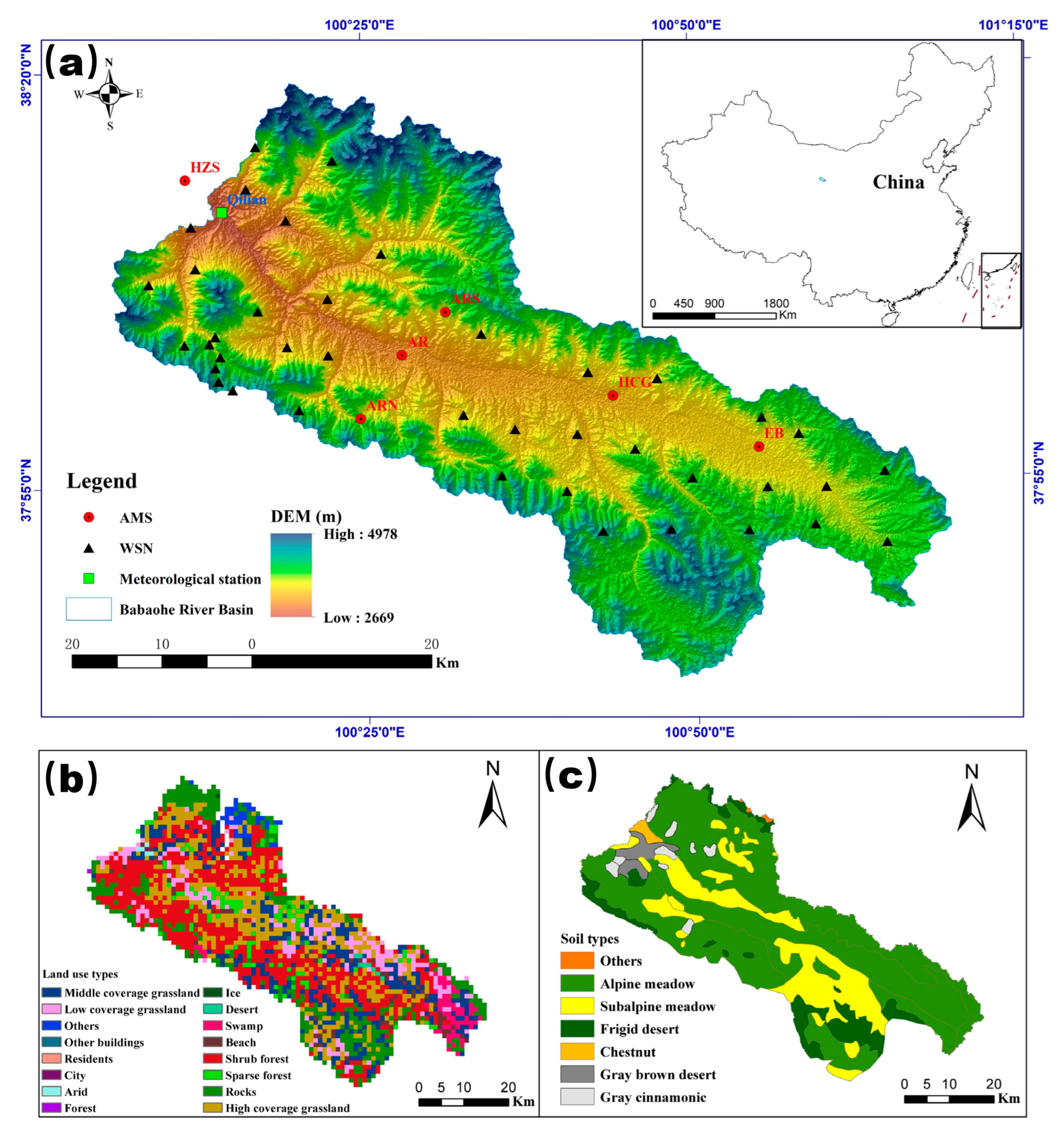
2.1. Study Area
2.2. China Meteorological Data Service Centre (CMD) Precipitation Dataset
2.3. Remote Sensing Soil Moisture Products
2.3.1. Advanced Scatterometer Data
2.3.2. Soil Moisture and Ocean Salinity Data
2.3.3. Soil Moisture Active and Passive Data
2.4. Remote Sensing Rainfall Data
2.5. China Meteorological Forcing Dataset
2.6. GPM-SM2RAIN Dataset
2.7. Climate Hazards Group InfraRed Precipitation with Station Data (CHIRPS) Dataset
2.8. ERA5-Land (ERA5) Dataset
2.9. Multi-Source Weighted-Ensemble Precipitation (MSWEP) Dataset
2.10. Ground Soil Moisture and Rainfall Data
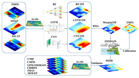
3. Methodology
3.1. Data Processing
3.2. SM2RAIN Model
3.3. Model Calibration
3.4. Machine Learning Methods
3.4.1. Random Forest
3.4.2. Long Short-Term Memory
- A dynamic balance between the previous experience and its reevaluation according to a new experience (modulated by the forget gate);
- The semantic effect of the current input (modulated by the input gate) and the potential additive activation.
3.4.3. Convolutional Neural Network
3.5. Classical Validation
3.6. Triple-Collocation Analysis
3.7. Spatial and Temporal Analysis of SM Products
4. Results
4.1. Assessment of the Merged Soil Moisture Product with WSN
4.2. Classical Validation of SM2R Using High-Quality Ground-Based Observations
4.3. Validation of SM2R Using Triple-Collocation Analysis
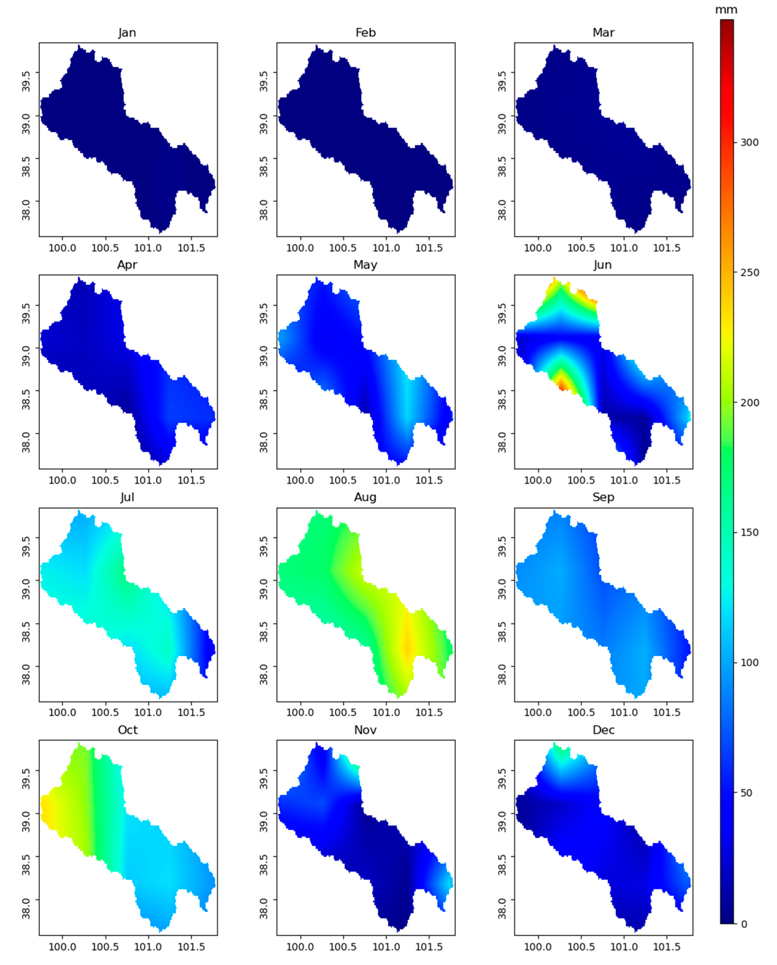
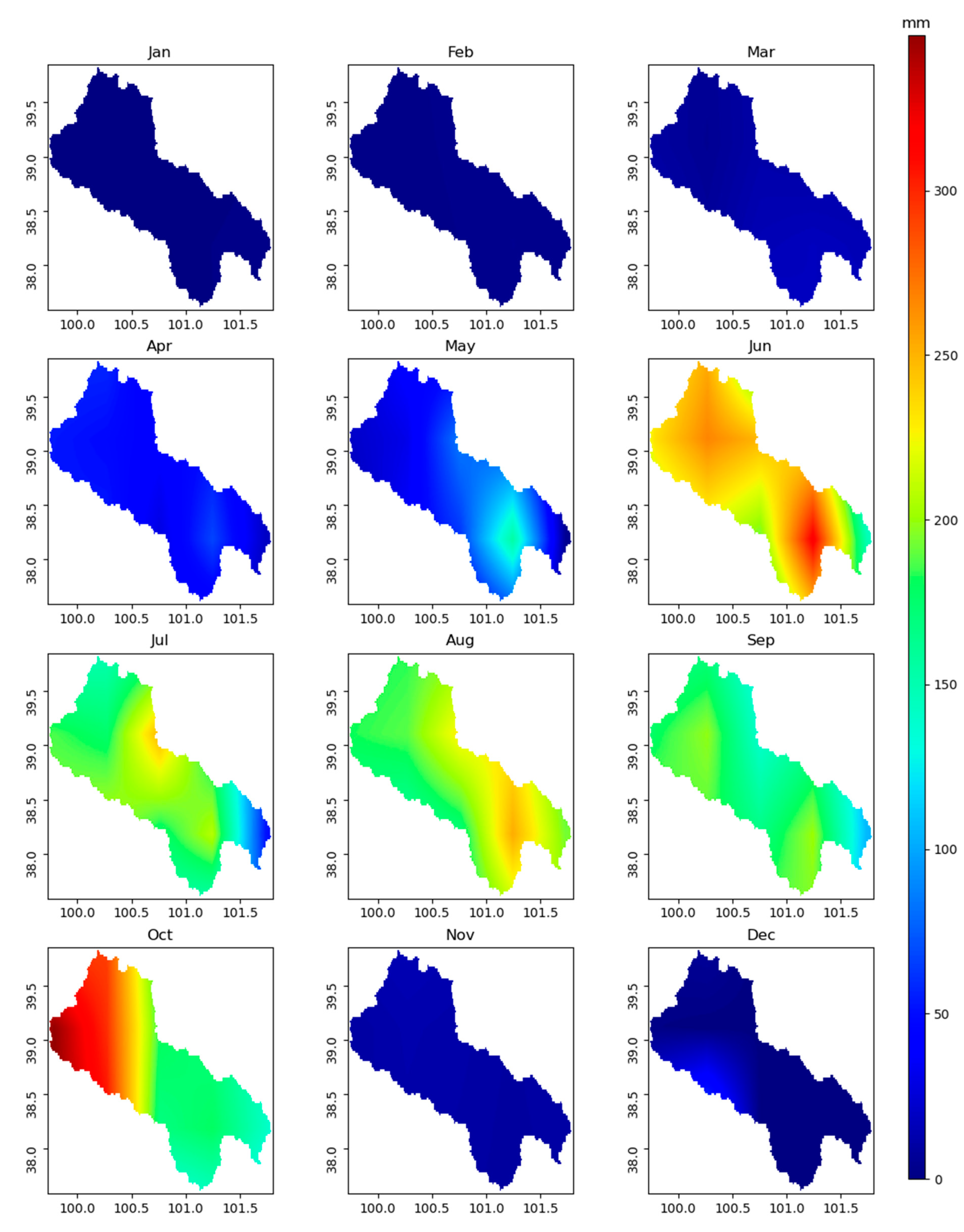
4.4. Spatial and Temporal Analysis of SM and SM2R
5. Discussion
6. Conclusions
Author Contributions
Funding
Data Availability Statement
Acknowledgments
Conflicts of Interest
References
- Ravuri, S.; Lenc, K.; Willson, M.; Kangin, D.; Lam, R.; Mirowski, P.; Fitzsimons, M.; Athanassiadou, M.; Kashem, S.; Madge, S.; et al. Skilful precipitation nowcasting using deep generative models of radar. Nature 2021, 597, 672–677. [Google Scholar] [CrossRef] [PubMed]
- Kidd, C.; Levizzani, V. Status of satellite precipitation retrievals. Hydrol. Earth Syst. Sci. 2011, 15, 1109–1116. [Google Scholar] [CrossRef] [Green Version]
- Zhang, Y.; Zhang, L.; Hou, J.L.; Gu, J.; Huang, C.L. Development of an Evapotranspiration Data Assimilation Technique for Streamflow Estimates: A Case Study in a Semi-Arid Region. Sustainability 2017, 9, 1658. [Google Scholar] [CrossRef] [Green Version]
- Zhang, Y.; Hou, J.L.; Gu, J.; Huang, C.L.; Li, X. SWAT-Based Hydrological Data Assimilation System (SWAT-HDAS): Description and Case Application to River Basin-Scale Hydrological Predictions. J. Adv. Model. Earth Syst. 2017, 9, 2863–2882. [Google Scholar] [CrossRef] [Green Version]
- Zhang, Y.; Hou, J.H.; Cao, Y.P.; Gu, J.; Huang, C.L. OpenMP parallelization of a gridded SWAT (SWATG). Comput. Geosci. 2017, 109, 228–237. [Google Scholar] [CrossRef]
- Tian, Y.; Peters-Lidard, C.D.; Choudhury, B.J.; Garcia, M. Multitemporal analysis of TRMM-based satellite precipitation products for land data assimilation applications. J. Hydrometeorol. 2007, 8, 1165–1183. [Google Scholar] [CrossRef]
- Huffman, G.J.; Adler, R.F.; Bolvin, D.T.; Gu, G.J.; Nelkin, E.J.; Bowman, K.P.; Hong, Y.; Stocker, E.F.; Wolff, D.B. The TRMM multisatellite precipitation analysis (TMPA): Quasi-global, multiyear, combined-sensor precipitation estimates at fine scales. J. Hydrometeorol. 2007, 8, 38–55. [Google Scholar] [CrossRef]
- Brocca, L.; Massari, C.; Pellarin, T.; Filippucci, P.; Ciabatta, L.; Camici, S.; Kerr, Y.H.; Fernandez-Prieto, D. River flow prediction in data scarce regions: Soil moisture integrated satellite rainfall products outperform rain gauge observations in West Africa. Sci. Rep. 2020, 10, 12517. [Google Scholar] [CrossRef]
- Hutchinson, M.F. Interpolation of Rainfall Data with Thin Plate Smoothing Splines—Part I: Two Dimensional Smoothing of Data with Short Range Correlation. J. Geogr. Inf. Decis. Anal. 1998, 2, 153–167. [Google Scholar]
- Tarpanelli, A.; Massari, C.; Ciabatta, L.; Filippucci, P.; Amarnath, G.; Brocca, L. Exploiting a constellation of satellite soil moisture sensors for accurate rainfall estimation. Adv. Water Resour. 2017, 108, 249–255. [Google Scholar] [CrossRef]
- Maggioni, V.; Massari, C. on the performance of satellite precipitation products in riverine flood modeling: A review. J. Hydrol. 2018, 558, 214–224. [Google Scholar] [CrossRef]
- Adane, G.B.; Hirpa, B.A.; Lim, C.H.; Lee, W.K. Evaluation and Comparison of Satellite-Derived Estimates of Rainfall in the Diverse Climate and Terrain of Central and Northeastern Ethiopia. Remote Sens. 2021, 13, 1275. [Google Scholar] [CrossRef]
- Fok, H.S.; Chen, Y.T.; Wang, L.; Tenzer, R.; He, Q. Improved Mekong Basin Runoff Estimate and Its Error Characteristics Using Pure Remotely Sensed Data Products. Remote Sens. 2021, 13, 996. [Google Scholar] [CrossRef]
- Rahman, K.U.; Shang, S.H.; Zohaib, M. Assessment of Merged Satellite Precipitation Datasets in Monitoring Meteorological Drought over Pakistan. Remote Sens. 2021, 13, 1662. [Google Scholar] [CrossRef]
- Turk, F.J.; Hristova-Veleva, S.; Giglio, D. Examination of the Daily Cycle Wind Vector Modes of Variability from the Constellation of Microwave Scatterometers and Radiometers. Remote Sens. 2021, 13, 141. [Google Scholar] [CrossRef]
- Ullah, S.; Zuo, Z.K.; Zhang, F.Z.; Zheng, J.H.; Huang, S.F.; Lin, Y.; Iqbal, I.; Sun, Y.Y.; Yang, M.; Yan, L. GPM-Based Multitemporal Weighted Precipitation Analysis Using GPM_IMERGDF Product and ASTER DEM in EDBF Algorithm. Remote Sens. 2020, 12, 3162. [Google Scholar] [CrossRef]
- Sharma, S.; Chen, Y.Y.; Zhou, X.; Yang, K.; Li, X.; Niu, X.L.; Hu, X.; Khadka, N. Evaluation of GPM-Era Satellite Precipitation Products on the Southern Slopes of the Central Himalayas Against Rain Gauge Data. Remote Sens. 2020, 12, 1836. [Google Scholar] [CrossRef]
- Getirana, A.; Kirschbaum, D.; Mandarino, F.; Ottoni, M.; Khan, S.; Arsenault, K. Potential of GPM IMERG Precipitation Estimates to Monitor Natural Disaster Triggers in Urban Areas: The Case of Rio de Janeiro, Brazil. Remote Sens. 2020, 12, 4095. [Google Scholar] [CrossRef]
- Laviola, S.; Monte, G.; Levizzani, V.; Ferraro, R.R.; Beauchamp, J. A New Method for Hail Detection from the GPM Constellation: A Prospect for a Global Hailstorm Climatology. Remote Sens. 2020, 12, 3553. [Google Scholar] [CrossRef]
- Ma, M.H.; Wang, H.X.; Jia, P.F.; Tang, G.Q.; Wang, D.C.; Ma, Z.Q.; Yan, H.M. Application of the GPM-IMERG Products in Flash Flood Warning: A Case Study in Yunnan, China. Remote Sens. 2020, 12, 1954. [Google Scholar] [CrossRef]
- Li, X.; Chen, Y.B.; Deng, X.C.; Zhang, Y.Y.; Chen, L.F. Evaluation and Hydrological Utility of the GPM IMERG Precipitation Products over the Xinfengjiang River Reservoir Basin, China. Remote Sens. 2021, 13, 866. [Google Scholar] [CrossRef]
- Wang, J.X.; Petersen, W.A.; Wolff, D.B. Validation of Satellite-Based Precipitation Products from TRMM to GPM. Remote Sens. 2021, 13, 1745. [Google Scholar] [CrossRef]
- Li, Y.; Wang, W.S.; Wang, G.Q.; Yu, S.Y. Evaluation and Hydrological Application of a Data Fusing Method of Multi-Source Precipitation Products-A Case Study over Tuojiang River Basin. Remote Sens. 2021, 13, 2630. [Google Scholar] [CrossRef]
- North, G.R.; Shen, S.S.P.; Upson, R. Sampling Errors in Rainfall Estimates by Multiple Satellites. J. Appl. Meteorol. 1993, 32, 399–410. [Google Scholar] [CrossRef]
- Zhu, D.T.; Zhang, K.F.; Yang, L.; Wu, S.Q.; Li, L.J. Evaluation and Calibration of MODIS Near-Infrared Precipitable Water Vapor over China Using GNSS Observations and ERA-5 Reanalysis Dataset. Remote Sens. 2021, 13, 2761. [Google Scholar] [CrossRef]
- Dee, D.P.; Uppala, S.M.; Simmons, A.J.; Berrisford, P.; Poli, P.; Kobayashi, S.; Andrae, U.; Balmaseda, M.A.; Balsamo, G.; Bauer, P.; et al. The ERA-Interim reanalysis: Configuration and performance of the data assimilation system. Q. J. R. Meteorol. Soc. 2011, 137, 553–597. [Google Scholar] [CrossRef]
- Wang, L.; Zhang, Y.H.; Yao, Y.J.; Xiao, Z.Q.; Shang, K.; Guo, X.Z.; Yang, J.M.; Xue, S.H.; Wang, J. GBRT-Based Estimation of Terrestrial Latent Heat Flux in the Haihe River Basin from Satellite and Reanalysis Datasets. Remote Sens. 2021, 13, 1054. [Google Scholar] [CrossRef]
- Beck, H.E.; van Dijk, A.; Levizzani, V.; Schellekens, J.; Miralles, D.G.; Martens, B.; de Roo, A. MSWEP: 3-hourly 0.25 degrees global gridded precipitation (1979–2015) by merging gauge, satellite, and reanalysis data. Hydrol. Earth Syst. Sci. 2017, 21, 589–615. [Google Scholar] [CrossRef] [Green Version]
- Jiang, Q.; Li, W.Y.; Fan, Z.D.; He, X.G.; Sun, W.W.; Chen, S.; Wen, J.H.; Gao, J.; Wang, J. Evaluation of the ERA5 reanalysis precipitation dataset over Chinese Mainland. J. Hydrol. 2021, 595, 125660. [Google Scholar] [CrossRef]
- Funk, C.; Peterson, P.; Landsfeld, M.; Pedreros, D.; Verdin, J.; Shukla, S.; Husak, G.; Rowland, J.; Harrison, L.; Hoell, A.; et al. The climate hazards infrared precipitation with stations-a new environmental record for monitoring extremes. Sci. Data 2015, 2, 150066. [Google Scholar] [CrossRef] [Green Version]
- Brocca, L.; Moramarco, T.; Melone, F.; Wagner, W. A new method for rainfall estimation through soil moisture observations. Geophys. Res. Lett. 2013, 40, 853–858. [Google Scholar] [CrossRef]
- Massari, C.; Maggioni, V.; Barbetta, S.; Brocca, L.; Ciabatta, L.; Camici, S.; Moramarco, T.; Coccia, G.; Todini, E. complementing near-real time satellite rainfall products with satellite soil moisture-derived rainfall through a Bayesian Inversion approach. J. Hydrol. 2019, 573, 341–351. [Google Scholar] [CrossRef]
- Wanders, N.; Pan, M.; Wood, E.F. Correction of real-time satellite precipitation with multi-sensor satellite observations of land surface variables. Remote Sens. Environ. 2015, 160, 206–221. [Google Scholar] [CrossRef]
- Ciabatta, L.; Massari, C.; Brocca, L.; Gruber, A.; Reimer, C.; Hahn, S.; Paulik, C.; Dorigo, W.; Kidd, R.; Wagner, W. SM2RAIN-CCI: A new global long-term rainfall data set derived from ESA CCI soil moisture. Earth Syst. Sci. Data 2018, 10, 267–280. [Google Scholar] [CrossRef] [Green Version]
- Kolluru, V.; Kolluru, S.; Wagle, N.; Acharya, T.D. Secondary Precipitation Estimate Merging Using Machine Learning: Development and Evaluation over Krishna River Basin, India. Remote Sens. 2020, 12, 3013. [Google Scholar] [CrossRef]
- Breiman, L. Random forests. Mach. Learn. 2001, 45, 5–32. [Google Scholar] [CrossRef] [Green Version]
- Hochreiter, S.; Schmidhuber, J. Long short-term memory. Neural Comput. 1997, 9, 1735–1780. [Google Scholar] [CrossRef]
- Teimouri, N.; Dyrmann, M.; Jorgensen, R.N. A Novel Spatio-Temporal FCN-LSTM Network for Recognizing Various Crop Types Using Multi-Temporal Radar Images. Remote Sens. 2019, 11, 990. [Google Scholar] [CrossRef] [Green Version]
- Rajendran, G.B.; Kumarasamy, U.M.; Zarro, C.; Divakarachari, P.B.; Ullo, S.L. Land-Use and Land-Cover Classification Using a Human Group-Based Particle Swarm Optimization Algorithm with an LSTM Classifier on Hybrid Pre-Processing Remote-Sensing Images. Remote Sens. 2020, 12, 4135. [Google Scholar] [CrossRef]
- Gao, W.L.; Gao, J.X.; Yang, L.; Wang, M.J.; Yao, W.H. A Novel Modeling Strategy of Weighted Mean Temperature in China Using RNN and LSTM. Remote Sens. 2021, 13, 3004. [Google Scholar] [CrossRef]
- Zhang, L.; Zhang, J.Z.; Niu, J.; Wu, Q.M.J.; Li, G.S. Track Prediction for HF Radar Vessels Submerged in Strong Clutter Based on MSCNN Fusion with GRU-AM and AR Model. Remote Sens. 2021, 13, 2164. [Google Scholar] [CrossRef]
- Feng, Y.; Zhang, T.S.; Sah, A.P.; Han, L.; Zhang, Z.T. Using Appearance to Predict Pedestrian Trajectories Through Disparity-Guided Attention and Convolutional LSTM. IEEE Trans. Veh. Technol. 2021, 70, 7480–7494. [Google Scholar] [CrossRef]
- Wang, G.Y.; Li, Z.B.; Li, G.J.; Dai, G.Y.; Xiao, Q.; Bai, L.; He, Y.S.; Liu, Y.X.; Bai, S. Real-time liver tracking algorithm based on LSTM and SVR networks for use in surface-guided radiation therapy. Radiat. Oncol. 2021, 16, 13. [Google Scholar] [CrossRef] [PubMed]
- Xie, G.; Niculescu, S. Mapping and Monitoring of Land Cover/Land Use (LCLU) Changes in the Crozon Peninsula (Brittany, France) from 2007 to 2018 by Machine Learning Algorithms (Support Vector Machine, Random Forest, and Convolutional Neural Network) and by Post-classification Comparison (PCC). Remote Sens. 2021, 13, 3899. [Google Scholar]
- Krizhevsky, A.; Sutskever, I.; Hinton, G. ImageNet Classification with Deep Convolutional Neural Networks. Adv. Neural Inf. Process. Syst. 2012, 25, 1097–1105. [Google Scholar] [CrossRef] [Green Version]
- Wang, H.; Ding, Z.D.; Li, X.Y.; Shen, S.Y.; Ye, X.D.; Zhang, D.; Tao, S.F. Convolutional Neural Network with a Learnable Spatial Activation Function for SAR Image Despeckling and Forest Image Analysis. Remote Sens. 2021, 13, 3444. [Google Scholar] [CrossRef]
- Nomura, R.; Oki, K. Downscaling of MODIS NDVI by Using a Convolutional Neural Network-Based Model with Higher Resolution SAR Data. Remote Sens. 2021, 13, 732. [Google Scholar] [CrossRef]
- Hu, L.S.; Qin, M.J.; Zhang, F.; Du, Z.H.; Liu, R.Y. RSCNN: A CNN-Based Method to Enhance Low-Light Remote-Sensing Images. Remote Sens. 2021, 13, 62. [Google Scholar] [CrossRef]
- Liu, J.; Xu, Y.S.; Li, H.H.; Guo, J. Soil Moisture Retrieval in Farmland Areas with Sentinel Multi-Source Data Based on Regression Convolutional Neural Networks. Sensor 2021, 21, 877. [Google Scholar] [CrossRef]
- Srivastava, A.; Saco, P.M.; Rodriguez, J.F.; Kumari, N.; Chun, K.P.; Yetemen, O. The role of landscape morphology on soil moisture variability in semi-arid ecosystems. Hydrol. Process. 2021, 35, 118C329. [Google Scholar] [CrossRef]
- Fatichi, S.; Katul, G.G.; Ivanov, V.Y.; Pappas, C.; Paschalis, A.; Consolo, A.; Kim, J.; Burlando, P. Abiotic and biotic controls of soil moisture spatiotemporal variability and the occurrence of hysteresis. Water Resour. Res. 2015, 51, 3505–3524. [Google Scholar] [CrossRef]
- Wagner, W.; Hahn, S.; Kidd, R.; Melzer, T.; Bartalis, Z.; Hasenauer, S.; Figa-Saldana, J.; de Rosnay, P.; Jann, A.; Schneider, S.; et al. The ASCAT Soil Moisture Product: A Review of its Specifications, Validation Results, and Emerging Applications. Meteorol. Z. 2013, 22, 5–33. [Google Scholar] [CrossRef]
- Kerr, Y.H.; Waldteufel, P.; Wigneron, J.P.; Martinuzzi, J.M.; Font, J.; Berger, M. Soil moisture retrieval from space: The Soil Moisture and Ocean Salinity (SMOS) mission. IEEE Trans. Geosci. Remote Sens. 2001, 39, 1729–1735. [Google Scholar] [CrossRef]
- Chan, S.K.; Bindlish, R.; O’Neill, P.; Jackson, T.; Njoku, E.; Dunbar, S.; Chaubell, J.; Piepmeier, J.; Yueh, S.; Entekhabi, D.; et al. Development and assessment of the SMAP enhanced passive soil moisture product. Remote Sens. Environ. 2018, 204, 931–941. [Google Scholar] [CrossRef] [PubMed] [Green Version]
- Entekhabi, D.; Njoku, E.G.; O’Neill, P.E.; Kellogg, K.H.; Crow, W.T.; Edelstein, W.N.; Entin, J.K.; Goodman, S.D.; Jackson, T.J.; Johnson, J.; et al. The Soil Moisture Active Passive (SMAP) Mission. Proc. IEEE 2010, 98, 704–716. [Google Scholar] [CrossRef]
- Kun, Y.; Jie, H. China Meteorological Forcing Dataset (1979–2018); National Tibetan Plateau Data Center: Qinghai, China, 2019. [Google Scholar] [CrossRef]
- He, J.; Yang, K.; Tang, W.; Lu, H.; Qin, J.; Chen, Y.; Li, X. The first high-resolution meteorological forcing dataset for land process studies over China. Sci. Data 2020, 7, 25. [Google Scholar] [CrossRef] [Green Version]
- Massari, C.; Brocca, L.; Pellarin, T.; Abramowitz, G.; Filippucci, P.; Ciabatta, L.; Maggioni, V.; Kerr, Y.; Fernandez Prieto, D. A daily 25 km short-latency rainfall product for data-scarce regions based on the integration of the Global Precipitation Measurement mission rainfall and multiple-satellite soil moisture products. Hydrol. Earth Syst. Sci. 2020, 24, 2687–2710. [Google Scholar] [CrossRef]
- Li, X.; Cheng, G.D.; Liu, S.M.; Xiao, Q.; Ma, M.G.; Jin, R.; Che, T.; Liu, Q.H.; Wang, W.Z.; Qi, Y.; et al. Heihe Watershed Allied Telemetry Experimental Research (HiWATER): Scientific Objectives and Experimental Design. Bull. Am. Meteorol. Soc. 2013, 94, 1145–1160. [Google Scholar] [CrossRef]
- Vernimmen, R.R.E.; Hooijer, A.; Mamenun; Aldrian, E.; van Dijk, A.I.J.M. Evaluation and bias correction of satellite rainfall data for drought monitoring in Indonesia. Hydrol. Earth Syst. Sci. 2012, 16, 133–146. [Google Scholar] [CrossRef] [Green Version]
- Brocca, L.; Filippucci, P.; Hahn, S.; Ciabatta, L.; Massari, C.; Camici, S.; Schuller, L.; Bojkov, B.; Wagner, W. SM2RAIN-ASCAT (2007–2018): Global daily satellite rainfall data from ASCAT soil moisture observations. Earth Syst. Sci. Data 2019, 11, 1583–1601. [Google Scholar] [CrossRef] [Green Version]
- Gupta, H.V.; Kling, H.; Yilmaz, K.K.; Martinez, G.F. Decomposition of the mean squared error and NSE performance criteria: Implications for improving hydrological modelling. J. Hydrol. 2009, 377, 80–91. [Google Scholar] [CrossRef]
- Wang, Z.Y.; Li, X.F.; Duan, H.R.; Su, Y.C.; Zhang, X.L.; Guan, X.J. Medical image fusion based on convolutional neural networks and non-subsampled contourlet transform. Expert Syst. Appl. 2021, 171, 114574. [Google Scholar] [CrossRef]
- Stoffelen, A. Toward the true near-surface wind speed: Error modeling and calibration using triple collocation. J. Geophys. Res. Ocean. 1998, 103, 7755–7766. [Google Scholar] [CrossRef]
- Chen, F.; Crow, W.T.; Bindlish, R.; Colliander, A.; Burgin, M.S.; Asanuma, J.; Aida, K. Global-scale evaluation of SMAP, SMOS and ASCAT soil moisture products using triple collocation. Remote Sens. Environ. 2018, 214, 1–13. [Google Scholar] [CrossRef]
- Zhu, G.F.; Li, X.; Zhang, K.; Ding, Z.Y.; Han, T.; Ma, J.Z.; Huang, C.L.; He, J.H.; Ma, T. Multi-model ensemble prediction of terrestrial evapotranspiration across north China using Bayesian model averaging. Hydrol. Process. 2016, 30, 2861–2879. [Google Scholar] [CrossRef]
- Zhang, L.; Ren, D.; Nan, Z.; Wang, W.; Zhao, Y.; Zhao, Y.; Ma, Q.; Wu, X. Interpolated or satellite-based precipitation? Implications for hydrological modeling in a meso-scale mountainous watershed on the Qinghai-Tibet Plateau. J. Hydrol. 2020, 583, 124629. [Google Scholar] [CrossRef]
- Meng, X.J.; Mao, K.B.A.; Meng, F.; Shi, J.C.; Zeng, J.Y.; Shen, X.Y.; Cui, Y.K.; Jiang, L.M.; Guo, Z.H. A fine-resolution soil moisture dataset for China in 2002–2018. Earth Syst. Sci. Data 2021, 13, 3239–3261. [Google Scholar] [CrossRef]
- Chen, W.; Shen, H.; Huang, C.; Li, X. Improving Soil Moisture Estimation with a Dual Ensemble Kalman Smoother by Jointly Assimilating AMSR-E Brightness Temperature and MODIS LST. Remote Sens. 2017, 9, 273. [Google Scholar] [CrossRef] [Green Version]
- Huang, C.; Chen, W.; Li, Y.; Shen, H.; Li, X. Assimilating multi-source data into land surface model to simultaneously improve estimations of soil moisture, soil temperature, and surface turbulent fluxes in irrigated fields. Agric. Meteorol. 2016, 230–231, 142–156. [Google Scholar] [CrossRef] [Green Version]
- Ma, L.; Liu, Y.; Zhang, X.L.; Ye, Y.X.; Yin, G.F.; Johnson, B.A. Deep learning in remote sensing applications: A meta-analysis and review. ISPRS J. Photogramm. 2019, 152, 166–177. [Google Scholar] [CrossRef]
- Zhang, W.J.; Xue, X.; Peng, F.; You, Q.G.; Hao, A.H. Meta-analysis of the effects of grassland degradation on plant and soil properties in the alpine meadows of the Qinghai-Tibetan Plateau. Glob. Ecol. Conserv. 2019, 20, e00774. [Google Scholar] [CrossRef]


| AMS | R | RMSE (mm) | Bias (mm) | Land Cover | Soil Type |
|---|---|---|---|---|---|
| AR | 0.9/0.62/0.25/0.28/0.27 | 1.98/2.32/2.62/4.37/2.71 | −0.88/−1.1/0.99/2.31/1.01 | High Coverage Grassland | alpine meadow soil |
| ARN | 0.7/0.55/0.35/0.7/0.54 | 3.30/3.63/3.65/4.2/3.61 | −1.51/−1.9/1.48/1.93/1.49 | High Coverage Grassland | alpine meadow soil |
| EB | 0.84/0.61/0.26/0.32/0.25 | 2.58/3.5/3.39/4.8/3.23 | −1.21/−1.7/1.79/2.1/1.94 | Middle Coverage Grassland | alpine meadow soil |
| HCG | 0.17/0.23/0.13/0.64/0.48 | 4.86/4.38/4.75/5.1/3.71 | −2.29/−2.1/2.46/2.39/2.77 | Low Coverage Grassland | alpine meadow soil |
| HZS | 0.32/0.26/0.1/0.6/0.5 | 3.83/4.02/4.34/4.2/2.74 | −1.61/−1.8/1.73/2.13/1.66 | Cropland | chestnut soil |
| ARS | 0.563/0.45/0.29/0.23/0.3 | 4.20/4.14/4.32/5.1/4.13 | −2.1/−2.5/2.81/2.2/2.24 | Low Coverage Grassland | alpine meadow soil |
| Month | Range (m3/m3) | Median (m3/m3) | Mean (m3/m3) | Std (m3/m3) | CV |
|---|---|---|---|---|---|
| 1 | 0.036–0.045 | 0.04 | 0.04 | 0.002 | 0.05 |
| 2 | 0.035–0.052 | 0.044 | 0.043 | 0.005 | 0.105 |
| 3 | 0.043–0.131 | 0.083 | 0.079 | 0.028 | 0.349 |
| 4 | 0.104–0.333 | 0.274 | 0.241 | 0.081 | 0.335 |
| 5 | 0.282–0.371 | 0.338 | 0.326 | 0.029 | 0.09 |
| 6 | 0.343–0.453 | 0.384 | 0.382 | 0.023 | 0.061 |
| 7 | 0.309–0.449 | 0.368 | 0.372 | 0.041 | 0.11 |
| 8 | 0.292–0.389 | 0.363 | 0.354 | 0.024 | 0.067 |
| 9 | 0.323–0.381 | 0.358 | 0.356 | 0.017 | 0.049 |
| 10 | 0.232–0.341 | 0.321 | 0.308 | 0.032 | 0.102 |
| 11 | 0.077–0.261 | 0.135 | 0.153 | 0.053 | 0.346 |
| 12 | 0.04–0.038 | 0.05 | 0.05 | 0.01 | 0.158 |
| Annual | 0.035–0.453 | 0.308 | 0.241 | 0.135 | 0.561 |
Publisher’s Note: MDPI stays neutral with regard to jurisdictional claims in published maps and institutional affiliations. |
© 2022 by the authors. Licensee MDPI, Basel, Switzerland. This article is an open access article distributed under the terms and conditions of the Creative Commons Attribution (CC BY) license (https://creativecommons.org/licenses/by/4.0/).
Share and Cite
Zhang, Y.; Hou, J.; Huang, C. Integration of Satellite-Derived and Ground-Based Soil Moisture Observations for a Precipitation Product over the Upper Heihe River Basin, China. Remote Sens. 2022, 14, 5355. https://0-doi-org.brum.beds.ac.uk/10.3390/rs14215355
Zhang Y, Hou J, Huang C. Integration of Satellite-Derived and Ground-Based Soil Moisture Observations for a Precipitation Product over the Upper Heihe River Basin, China. Remote Sensing. 2022; 14(21):5355. https://0-doi-org.brum.beds.ac.uk/10.3390/rs14215355
Chicago/Turabian StyleZhang, Ying, Jinliang Hou, and Chunlin Huang. 2022. "Integration of Satellite-Derived and Ground-Based Soil Moisture Observations for a Precipitation Product over the Upper Heihe River Basin, China" Remote Sensing 14, no. 21: 5355. https://0-doi-org.brum.beds.ac.uk/10.3390/rs14215355