Article

Spatial and Temporal Characteristics of Water Use Efficiency in Typical Ecosystems on the Loess Plateau in the Last 20 Years, with Drivers and Implications for Ecological Restoration

1
College of Geoscience and Surveying Engineering, China University of Mining and Technology, Beijing 100083, China
2
Aerospace Information Research Institute, Chinese Academy of Sciences, Beijing 100094, China
*
Author to whom correspondence should be addressed.
These authors contributed equally to this work.
Remote Sens. 2022, 14(22), 5632; https://0-doi-org.brum.beds.ac.uk/10.3390/rs14225632
Submission received: 23 August 2022 / Revised: 5 November 2022 / Accepted: 5 November 2022 / Published: 8 November 2022
(This article belongs to the Special Issue Seasonal Vegetation Index Changes: Cases and Solutions)

Abstract

:
The water use efficiency (WUE) is an essential indicator of carbon–water coupling between terrestrial ecosystems and the atmosphere, and it is an important parameter for studying ecosystem responses to global climate change. A comprehensive understanding of the water–carbon coupling process in the Loess Plateau can reflect the balance between the “carbon absorption” and “water consumption” in vegetation, which drives the ecosystem succession process. In recent years, scholars have gained a more comprehensive understanding of the WUE and the driving factors of the Loess Plateau. However, there is still a need to study the carbon and water coupling mechanisms of different land use types in the Loess Plateau region. In this article, based on the gross primary productivity (GPP), evapotranspiration (ET), surface cover remote sensing products, and meteorological observation data, the trend of WUE changes for different vegetation types in the Loess Plateau from 2001 to 2020 and the correlations with the Normalized Difference Vegetation Index (NDVI), precipitation, and temperature values were analyzed using the Theil–Sen median (SEN) trend analysis method and correlation coefficient analysis method. The spatial distribution patterns of the changes with the drought index showed that the multi-year average WUE value of the Loess Plateau was 1.24 g C mm−1 H2O, and the mean WUE values in different seasons were ranked as follows: summer > autumn > spring. The WUE growth rates of all vegetation types showed a decreasing trend with the increase in drought index, and the size of the WUE response rate for each vegetation type to drought was ranked as follows: grassland > forest > shrub > crop. The annual average WUE increase rate of the Loess Plateau was 0.02 g C mm−1 H2O yr−1, of which 93.36% of the area showed an increasing trend. The NDVI was the dominant factor affecting the spatial and temporal variations in WUE rates in the Loess Plateau, and the correlation between the NDVI and WUE was strongest in summer. In the more arid regional ecosystems, the WUE was negatively correlated with the precipitation and temperature, but in summer the precipitation had a positive effect on the WUE. The correlation of grassland and shrub WUE rates with temperature was more sensitive to the drought index than that of the forest and crop areas, but there was also a threshold effect. Therefore, when vegetation restoration is carried out in arid and semi-arid regions, the carbon and water coupling mechanisms of different vegetation types and the reasonable allocation of regional water resources should be fully considered.

Graphical Abstract

1. Introduction

The ecosystem water use efficiency (WUE) is a measure of ecosystem carbon–water interactions and an important indicator of ecosystem sensitivity to climate change [1]. The WUE is commonly defined as the amount of dry matter fixed per unit mass of water consumed by terrestrial ecosystems, and there are many ways to express this WUE; usually, the ratio of gross primary productivity (GPP) to evapotranspiration (ET) is widely used [2]. The WUE not only reflects the vegetation carbon and water cycle mechanism and its coupling relationship, but also is a comprehensive physiological and ecological indicator to evaluate the suitability of plant growth. The WUE characteristics of different land cover types depend on the strength of the coupled GPP and ET components of the respective land cover types [3,4]. Therefore, studying the spatial variation characteristics and influencing factors of the WUE values of different land cover types can help to understand the hydrological processes of ecosystems and the response mechanisms of ecosystems to climate and water resources changes.
The Loess Plateau is in the north-central part of China and is one of the four major plateaus in China. The terrain slopes from northwest to southeast, except for the many stony hills, most of which are covered by thick layers of loess [5]. The Loess Plateau is characterized by high precipitation variability. The transition from forest to grassland, low vegetation cover, a poor ability to contain water, and unreasonable human deforestation due to farming, and mining [6], makes the Loess Plateau increasingly subject to soil erosion and one of the most seriously affected regions in the world [7]. As an important base for agricultural production and animal husbandry development in China, it is important to manage and protect the ecological environment of the Loess Plateau in a timely manner [8]. Since the implementation of the project of “returning crop to forest and grass” in 1999, many policies have been introduced to control soil erosion on the Loess Plateau. After 2000, the Loess Plateau was in the ecological restoration stage. The large-scale process of returning crops to forest and grass areas and the construction of green water and green mountain areas in this phase greatly improved the ecological environment of the Loess Plateau. However, with the excessive restoration of vegetation, a series of ecological problems have also arisen [9], motivating people to examine the problems of inefficient water use and unbalanced resource distribution in the ecological management and governance process. The water–carbon cycle and its interactions change greatly in the context of rapid vegetation changes on the Loess Plateau. Therefore, it is of great importance to investigate the dynamics of the ecosystem WUE on the carbon–water coupling relationship on the Loess Plateau. To further maintain the ecological balance of the Loess Plateau and promote the modernization of the ecological restoration management system and governance capacity for the future, it is important to understand the WUE and carbon–water coupling mechanism. As an important indicator for evaluating drought in ecosystem carbon-water connections, the Crop Water Stress Index (CWSI) typically plays a significant role [10]. According to studies, the GPP and ET processes are impacted by the CWSI, which in turn has an indirect impact on a terrestrial ecosystem’s WUE [8]. Numerous research studies have examined the mechanisms and processes of the WUE reactions to water shortages or droughts in the context of climate change [11,12,13]. When drought intensity or geographic latitude increase on a worldwide scale, the WUE often declines [14]. However, research has shown that the amount of drought and WUE are typically positively connected. In most of the forest, grassland, and shrub ecosystems, drought events can marginally raise WUE [10,15]. Furthermore, the response of the WUE to drought is spatially heterogeneous across spatial scales and across ecosystems. Therefore, studying the mechanism of the CWSI’s effects on the WUE is important for terrestrial ecosystem evolution and climate change responses.
In recent years, many scholars have used remote sensing methods to study plant WUE. Numerous studies have demonstrated that different spatial scales and ecosystems exhibit spatially variable water usage efficiency responses to drought [16,17]. The WUE often rises when soil moisture levels drop, or the severity of a drought intensifies [18]. Most places throughout the world show a positive correlation between the WUE and drought [19]. Most forest ecosystems in China have considerable tolerance to drought by raising their WUE [20]. It has been demonstrated that ET regulates how water usage efficiency responds to drought in semi-arid and high-latitude locations, while the GPP predominates in tropical forest zones [21]. Therefore, the CWSI plays a role in the WUE, both in GPP and ET pathways. However, in previous studies, it has been difficult to investigate the complex spatial heterogeneity of the Loess Plateau, meaning they could not investigate the carbon–water coupling mechanisms of different vegetation types. Therefore, in this paper, we study the carbon and water coupling mechanisms of different vegetation types among various ecosystems under water resource constraints in the Loess Plateau region, with complex spatial heterogeneity and a long time series, which will help clarify the driving forces of different carbon and water cycling mechanisms in ecosystem succession and provide a reference for the sustainable carbon sequestration potential of different vegetation types.

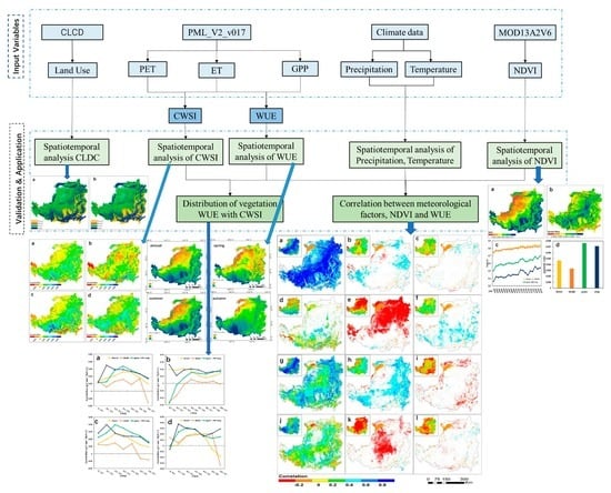
2. Materials and Methods

2.1. Study Area Introduction

The Loess Plateau (34~40°N, 103~114°E) is the largest loess accumulation area in the world and the largest loess-covered plateau in the world, located in the central-north of China, which belongs to the northern region. It mainly includes Shanxi and Shaanxi, as well as parts of Gansu, Qinghai, Ningxia, and Henan provinces, accounting for 70% of the distribution of loess in the world, and it is the largest loess accumulation area in the world [22]. The total area of the region is 63.5 × 10⁴ km2, of which 45.4 × 10⁴ km2 is a soil erosion area, which is the most serious soil erosion area and the most fragile ecological environment in China and even in the world (Figure 1). The region belongs to a typical arid and semi-arid continental monsoon climate zone with an average annual temperature range of 3.6~14.3 °C. Winter and spring are influenced by dry and cold polar air masses, which are cold, dry, and windy; summer and autumn are hot and humid, with an average multi-year rainfall rate of 466 mm, mainly concentrated between June and September, accounting for about 60% of the annual precipitation [23,24,25]. The winter precipitation generally accounts for only about 5% of the total. The vegetation in the study area shows a general trend of forest to grassland overgrowth from south to north. Most of the central part is a semi-arid grassland zone. In the northwestern part, the landscape gradually evolves into a desert, with desert grassland dominating.

2.2. Data Sources

The carbon cycle, water cycle, vegetation succession, and meteorological data for the Loess Plateau vegetation covered in this paper were obtained from the GEE self-contained data products. The GPP and ET data were derived from the PML_V2v0.1.7 data product (https://developers.google.com/earth-engine/datasets/catalog/CAS_IGSNRR_PML_V2_v017, accessed on 18 July 2021) to express ecosystem carbon uptake and water depletion rates [26]. The NDVI data were derived from the MOD13A2V6 product (https://developers.google.com/earth-engine/datasets/catalog/MODIS_006_MOD13A1, accessed on 18 July 2021) to express vegetation growth rates with an inter-data resolution of 500 m and a temporal resolution of 8 d. The land cover type data were derived from the GCL_FC30 product (http://data.casearth.cn, accessed on 18 July 2021) of the Institute of Space and Space Innovation, Chinese Academy of Sciences [8], which was derived from Landsat ground surface reflection data; a Chinese land cover product with a spatial resolution of 30 m was obtained using supervised classification. The meteorological data were obtained from the China Meteorological Science Data Center (http://data.cma.cn/, accessed on 18 July 2021). Fifty-two meteorological stations within the Loess Plateau involving the seven provinces of Shanxi, Qinghai, Ningxia, Inner Mongolia, Henan, Gansu, and Shaanxi were used, including precipitation and mean temperature data. The data used in this paper all range in time from 2000 to 2020, and the specific information is shown in Table 1.

2.3. Research Methods

2.3.1. Water Use Efficiency

Currently, there are different definitions and understandings of vegetation WUE in academia, and the results are expressed in different ways. The calculation of the WUE using the ratio of the GPP to ET is the most classical approach [27]. The calculation method is as follows:
W U E = G P P E T ,
where WUE is the water use efficiency (g C mm−1 H2O); GPP is the total primary productivity of the terrestrial ecosystems (g C-m−2); ET is the ecosystem evapotranspiration (mm-m−2).

2.3.2. Calculation of Drought Index

The crop water stress index (CWSI) has a clear physical meaning and is suitable for studying the degree of vegetation drought in semi-arid areas, which is based on the principle of surface balance and takes into account the vegetation cover rates of different substrates and meteorological elements, such as precipitation and temperature, and has been widely used in studies of agricultural drought [3]. The vegetation water deficit index (CWSI) is calculated from evapotranspiration data with the following equation:
C W S I = P E T E T P E T ,
where PET indicates the potential evapotranspiration in mm and ET indicates the actual evapotranspiration in mm. The CWSI values range from 0 to 1, with larger values representing areas under greater water stress, and vice versa.

2.4. Analysis Method

2.4.1. Land Use Transfer Matrix

The land use transfer matrix may effectively uncover and depict the structural aspects of land cover change, as well as the direction of change for various use types, and reflect the special characteristics of the process of land use type transfer change [28]. The transfer matrix equation is shown as follows:
P = P 11 P 1 j P i 1 P i j
where, Pij is the area of land use type i converted to type j land use type in different periods.

2.4.2. Trend Analysis

A trend analysis is a method of statistically testing trends in time series [29]. In this study, a combination of the Theil–Sen median (SEN) and Mann–Kendall (MK) statistical tests was used for a further analysis of the trends in environmental indicators in the study area. The formula is:
β = M e d i a n X j X i j i           j > i
where Median() represents the median value; Xj and Xi represents the j-th and i-th element; if β is greater than zero, this means that the time series shows an upward trend, and vice versa for a downward trend.

2.4.3. Correlation Analysis

In this study, the Pearson coefficients were used to analyze the correlations of each factor, which were calculated as shown below [27,30]:
R = x x ¯ y y ¯ x x ¯ 2 y y ¯ 2
where R is the Pearson coefficient; x is the influence factor; and y is the dependent variable. The magnitude of R reflects the correlation between the factors, where R > 0 indicates a positive correlation and R < 0 indicates a negative correlation.

3. Result

3.1. Vegetation Cover Changes from 2001 to 2020

In this study, using the land use data for the Loess Plateau in 2001 and 2020, it can be seen from Figure 2 that the land cover types of the Loess Plateau show subtle spatial differences. The whole region shows a general trend of overgrowth of forest to grassland areas from south to north, with forest areas being concentrated in the valley plains of the Guanzhong Basin, Fen River Valley, and Luoyang Basin (Figure 2), accounting for 12.07% of the total area of the Loess Plateau in 2001 and increasing to 14.28% in 2020 (Table 2). Grassland is the most abundant type of land cover category, mainly distributed in the desert areas in the north (Figure 2) and increasing from 49.12 to 50.24% in 2001. The arable land is mainly distributed in the loess areas of the Longdong Plateau and the plateau areas on both sides of the Weihe River in the south of the Loess Plateau (Figure 2). Since the project of “returning crop to forest and grass areas” started, the area of arable land has been reduced from 31.73 to 28.83% (Table 2). The area covered by shrub is the smallest, which has been stable at less than 1% for many years and shows a decreasing trend (Table 2).
Although the areas of these four land cover types remained relatively stable from 2001 to 2020 (Table 2), the NDVI values showed an increasing trend (Figure 3a), and the vegetation cover of forest and scrub areas showed significant advantages compared with the other two classes (Figure 3c). Spatially, the NDVI values showed a significant increasing trend in most areas of the Loess Plateau, especially in the central-eastern part of the plateau (Figure 3b), where grassland is the main growth area. After counting the NDVI trends for different land cover types, it can be found that grassland has the fastest growth rate, followed by crop, while the slowest growth rate is for scrub (Figure 3d).

3.2. Seasonal Distribution Characteristics of WUE in the Loess Plateau

The spatial distribution of the annual average WUE rates for the Loess Plateau from 2001 to 2020 shows a clear spatial differentiation (Figure 4). The 20-year WUE average is 1.24 g C mm−1 H2O, which indicates that the loss of 1 mm of water through evapotranspiration in the Loess Plateau represents about 1.24 g of CO2 fixed by vegetation. In Shanxi, southern Shaanxi, and Henan provinces, the WUE values can be above 1.5 g C mm−1 H2O, mainly in cultivated and forested areas; the low-value areas were mainly in the Inner Mongolia Autonomous Region, Ningxia Hui Autonomous Region, Gansu Province, and Qinghai Province. The spatial distribution of WUE in different seasons over the years showed that the distribution of the WUE rates in different seasons showed the same distribution trend as that of the WUE rates over the whole year, while the average values from high to low were: summer (1.35 g C mm−1 H2O) (Figure 4c) > autumn (1.28 g C mm−1 H2O) (Figure 4d) > spring (1.07 g C mm−1 H2O) (Figure 4b).
Figure 4. Spatial distribution characteristics of WUE rates annual (a) spring (b) summer (c) autumn (d) in the Loess Plateau from 2001 to 2020.The variation pattern of the multi-year average WUE rates with the drought index rates for different vegetation types is shown in Figure 5. The data are averaged over the entire Loess Plateau region. From the figure, it can be seen that the WUE rates of the different vegetation types in descending order were forest > scrub > crop > grassland, with forest areas reaching 1.72 g C mm−1 H2O (Figure 5a). This paper also found that the WUE rates of all vegetation types decreased with the increase in CWSI, while the response rates of the WUE for each vegetation type to the increase in CWSI were ranked as grassland > crop > forest > shrub (Figure 5a). The rate of decline for the grassland WUE with the increase in CWSI was the fastest, indicating that the grassland WUE was the most sensitive to the changes in drought patterns. From the change pattern of the WUE rates with the drought index rates in different seasons, it can be seen that summer had the same response pattern as the whole-year pattern, while crop was the most sensitive to drought change responses in spring (Figure 5b); forest was the most sensitive to drought change responses in autumn (Figure 5d); and in both spring and autumn, grassland showed lower sensitivity to drought index changes (Figure 5b,d).
Remotesensing 14 05632 g004
Figure 5. The distribution trend of water use efficiency and CWSI rate of different vegetation types in the Loess Plateau in the annual (a) spring (b) summer (c) autumn (d).
Remotesensing 14 05632 g005

3.3. Seasonal Variation Characteristics of WUE Rates in the Loess Plateau

The spatial distribution of the interannual variation of the WUE rates in the Loess Plateau from 2001 to 2020 is shown in Figure 6. The WUE of the entire Loess Plateau is increasing at the rate of 0.02 g C mm−1 H2O per year, and the areas with increasing trends account for 93.36% of the Loess Plateau (Figure 6a). While the increasing areas are mainly distributed in the southern and central parts of the Loess Plateau, the decreasing areas are mainly distributed in the northwestern part of the Loess Plateau. In terms of the seasonal distribution, the WUE changes are slowest in spring, increasing at 0.01g C mm−1 H2O per year (Figure 6b), with 12.63% of the area showing a decreasing trend, especially in the western part of the Loess Plateau in Qinghai Province. The summer WUE increased at a rate of 0.03 g C mm−1 H2O per year, which was the fastest growth season of the year, and 18.94% of the regions showed an annual increase of more than 0.06 g C mm−1 H2O (Figure 6c) but showed a more obvious decreasing trend in the southern part of the Loess Plateau. Autumn showed a similar distribution pattern as summer, with 86.25% of the area showing an increasing trend (Figure 6d).
The variation curves of interannual WUE trends with the drought index rates for different vegetation types are shown in Figure 7. For the entire Loess Plateau, although the WUE rates of different vegetation types showed an increasing trend in the CWSI in the interval of 0.2–0.5, there are still large differences in the variation patterns of WUE growth rates with the drought index values for the different vegetation types. In order to consider the completeness of image information, the interval of CWSI in this paper starts from 0. However, when CWSI is less than 0.3, no artificial vegetation is subjected to water stress, so the analysis results are based on CWSI of 0.3 as the starting point. The WUE growth rate of agricultural land decreased with the increase in the drought index; however, the forest, shrub, and grassland areas all showed a pattern of increasing and then decreasing, and the peak of the WUE occurred in the CWSI range of 0.3–0.4 (Figure 7a). There were still large differences in WUE trends with drought index rates in different seasons. The rate of change of the WUE in crop areas was the largest in spring, increasing at 0.02 g C mm−1 H2O per year (Figure 7b), and fluctuated the least with the increase in drought index, while the rate of change for grassland areas showed an increasing trend the whole time with the increase in drought index. The summer grassland showed an increasing trend at a rate of 0.03 g C mm−1 H2O per year (Figure 7c) and was also the fastest growing among vegetation types. The pattern of WUE changes in autumn was similar to that for the whole year (Figure 7d). It is noteworthy that although the sensitivity of vegetation WUE to CWSI differs, there is an effect with it, which shows an increasing trend of vegetation WUE between CWSI interval of 0.2 and 0.6.

3.4. Spatial Distribution Characteristics of WUE and NDVI Rates, Precipitation, and Temperature Correlations in the Loess Plateau

The correlation coefficients of the Loess Plateau with NDVI, precipitation, and temperature values are shown in Figure 8. The figure shows that there are significant differences in the geographical distribution of the correlation between different influencing factors and WUE. In terms of the relationship between the vegetation WUE and individual factors in the study area, the vegetation WUE showed a strong positive correlation with the NDVI (Figure 8a), and the correlation coefficient between the NDVI and WUE was 0.71 in 93.51% of the areas that passed the significance test (Table 3). For the correlation between the NDVI and WUE in different seasons, the NDVI was most significantly correlated with the WUE in summer, with 91.63% of the areas passing the correlation test of p < 0.05 (Figure 8g) and with a correlation coefficient of 0.46 (Table 3). Only 23.84% of the areas passed the significance test in spring compared to the other two seasons, and these areas were mainly located in the southern part of the Loess Plateau (Figure 8d). The correlation in these areas was only 0.23 (Table 3).
The correlation between the WUE and precipitation was mildly positive, the area passing the significance test was only 18.26% of the Loess Plateau area (Figure 8b), and the correlation coefficient was 0.28 (Table 3), but there were still some areas showing a negative correlation, which were mainly distributed in a small part of Qinghai Province in the western part of the Loess Plateau. There were great differences in the correlation between precipitation and WUE in different seasons, and the precipitation and WUE values showed a stronger negative correlation in spring and autumn (Figure 8e,k), with the difference that 29.37% more regions passed the significance test in spring than in autumn. The summer precipitation–WUE correlation was most like the distribution pattern of correlations throughout the year, with both showing positive correlations, but the correlation between the summer precipitation and WUE was more significant.
The correlation between temperature and WUE was the weakest compared with the first two, indicating that the temperature had the least influence on the WUE in the Loess Plateau. The annual correlation between the temperature and WUE was 0.36 (Table 3), and only 9.82% of the regions passed the significance test, which were mainly located in parts of Inner Mongolia in the northern part of the Loess Plateau and parts of Shaanxi Province in the south (Figure 8c). For the different seasons, the correlation between the temperature and WUE still showed more obvious differences, and spring was the strongest correlation between the temperature and WUE among the three seasons, with 0.43 (Table 3) and 32.78% of the regions passing the significance test (Figure 8f). Only the summer temperature showed a non-significant negative correlation with the WUE (Figure 8i). The regions were mainly located in Shanxi Province and parts of Inner Mongolia. The effect of the autumn temperature on the WUE was the smallest, with a correlation of only 0.16 (Table 3).

4. Discussion

4.1. Spatial Distribution Characteristics of Spatial and Temporal Variation of the WUE in the Loess Plateau Ecosystem

The ecosystem WUE takes into account the relationship between the vegetation water consumption and dry material production, and it is an extensive physiological and ecological index used to assess the suitability of plant growth. In the water-scarce Loess Plateau region, it is important to clarify the distribution of the ecosystem WUE under different drought indices, as well as the changes and responses to the influencing factors. This paper investigates the seasonal distribution and changes of the WUE rates of different vegetation types on the Loess Plateau during 2001 to 2020. It was found that the WUE of the Loess Plateau showed obvious spatial heterogeneity in space, i.e., decreasing gradually from southeast to northwest [31,32] (Figure 4). Seasonally, the WUE of the vegetation started to increase in spring when the temperature started to pick up, the precipitation and sunshine hours kept increasing, and the surface plants entered the growth period [33]. The average temperature in summer was higher than 22 °C, which was suitable for vegetation growth, with sufficient precipitation and the longest sunshine hours, meaning vegetation growth was vigorous [34], so the vegetation WUE was higher relative to other seasons. Spatially, it was high-value areas concentrated in the forest in the south and east of Loess Plateau. In autumn, the temperature started to drop, the sunshine hours gradually shortened, the vegetation gradually withered [35], and the vegetation WUE started to retract. The autumn WUE distribution was more consistent with the annual average WUE, showing low rates in the northwest and high rates in the southeast, and the high-value areas were mainly distributed in Shanxi Province and southern Shaanxi. The southeastern part of the Loess Plateau cools down slowly in autumn, which is more favorable for vegetation growth.
Figure 5 shows that the highest WUE was found in the forests of the Loess Plateau, which was due to the fact that most of the forests comprise tree vegetation with larger leaves which have higher vegetation cover, stronger photosynthesis potential, and a well-developed root system, making them more capable of absorbing water from the soil compared to other vegetation types [36,37]. In spring, when the temperature rises and the vegetation starts to grow, slight droughts do not have much effect on water utilization in forests, so the forest WUE changes are less influenced by the drought index. Crop is more affected by anthropogenic irrigation activities [38], but crop in arid areas can still meet the water consumption needs of crops through anthropogenic irrigation, so this land cover type is least sensitive compared to other concentrated vegetation types. Summer is the season when crop fixes the most carbon, while evaporation is less than for other small vegetation types [39], so the WUE is higher in areas with crop distribution. The grasslands have a high adaptive capacity and are also the vegetation type comprising the largest area on the Loess Plateau, but due to the short root system of the grasslands [21], precipitation has become the main limiting factor, and the grasslands are subject to more severe water stress compared to other vegetation types. The hot temperatures in summer make the grassland WUE distribution more sensitive to drought indices.

4.2. Relationship between WUE and Impact Factor with CWSI

Figure 9 shows that the correlations between the different vegetation types and impact factors on the Loess Plateau show different patterns of change with the drought index values. The correlation between the ecosystem WUE and NDVI with increasing drought index values (Figure 9a) has the same variation pattern as for the growth trend of the WUE (Figure 7a), and both reach the peak in the interval of the CWSI of 0.3–0.4, which indicates that the NDVI dominates the spatial pattern of the interannual variation in WUE rates in the Loess Plateau. For the different seasonal variations, the correlation between the WUE and NDVI for the ecosystems showed a trend of decreasing and then increasing with increasing drought index values in spring (Figure 9d), and the drought index values were primarily affected by grassland and brush. The link between the WUE and NDVI for each type of plant in the summer revealed a trend of rising and then declining with rising values for the drought index because the proportion of water directly used for the photosynthesis of vegetation to total evapotranspiration gradually decreased with the increasing drought index values [40,41], so the correlation between the ecosystem WUE and NDVI began to decrease. The correlation between the rainfall and ecosystem WUE in the Loess Plateau showed different degrees of negative correlations in the more arid regions in the north (Figure 7b), which was due to the fact that this region is mostly covered with barren grass. The soil water content increases after rainfall but evaporates rapidly, resulting in an increase in total evapotranspiration and difficulty in using soil water for its own photosynthesis [42], so the WUE decreases. The temperature showed a non-significant positive correlation with the ecosystem WUE, and since the temperature affects the stomatal conductance and vegetation photosynthesis mainly through evapotranspiration [43], the correlation between the WUE and temperature is stronger in forests than in several other vegetation types. The negative correlation between the temperature and ecosystem WUE in summer is due to the low precipitation and uneven water heating in the Loess Plateau. As the drought index increases and the temperature rises, this will accelerate the evapotranspiration of the vegetation and reduce the WUE, especially in the scrub, and as the drought index increases, the stronger the negative correlation will be between the temperature and the WUE (Figure 9i).

5. Conclusions

In this paper, we analyzed the response of the WUE changes to regional climate and vegetation cover changes during the annual period of 2001 to 2020 using the PML GPP and ET datasets. Our results showed that the multi-year mean WUE value of the Loess Plateau is 1.24 g C mm−1 H2O, and the spatial pattern of the WUE varies among seasons, with the mean WUE size being ranked as summer > autumn > spring in the different seasons. The WUE rates of all vegetation types showed a decreasing trend with the increase in drought index values, and it was most obvious in summer. The magnitude of the response rate of the WUE to drought for each vegetation type was ranked as: grassland > forest > scrub > crop.
The annual average WUE increase rate for the Loess Plateau was 0.02 g C mm−1 H2O a−1, of which 93.36% of the area showed an increasing trend. Due to the difference in precipitation temperature in the different seasons, this led to the changes in WUE rates in different seasons still showing a big difference, and the mean WUE increase in summer was more significant. The NDVI was the dominant factor affecting the spatial and temporal variations in WUE in the Loess Plateau. The correlation between the NDVI and WUE was the strongest in summer. The change pattern of the NDVI values with the increase in drought index rates showed the same change pattern as for the growth trend of the WUE. The ecosystem WUE was negatively correlated with the precipitation temperature in drier regions, but throughout the summer, the precipitation boosted the WUE. In comparison to forest and crop regions, the link between the WUE and temperature in grassland and scrub areas was more sensitive to the values of the drought index, but there was also a threshold effect. Thus, for the arid and semi-arid Loess Plateau regions, these findings deepen our understanding of the carbon and water coupling mechanisms of different vegetation types, providing important ideas for the sustainable development of vegetation on the Loess Plateau and future ecological restoration management and governance approaches.

Author Contributions

Conceptualization: R.M.; Data curation: R.M. and D.W.; Formal analysis: R.M. and S.L.; Visualization: X.C. and S.W.; Writing—original draft preparation: R.M. and H.W.; Writing—review and editing: S.L. and X.Y. All authors have read and agreed to the published version of the manuscript.

Funding

This research was funded by the National Natural Science Foundation of China, 42141007; 41671362; 52274169 and the Special Funds for the Transformation of Scientific and Technological Achievements in the Inner Mongolia Autonomous Region 2021CG0045.

Data Availability Statement

The GPP and ET datasets are available from Google Earth Engine (GEE) at https://developers.google.com/earth−engine/datasets/catalog/CAS_IGSNRR_PML_V2_v017 (accessed on 20 July 2022). The NDVI datasets are available from GEE at https://developers.google.com/earth−engine/datasets/catalog/MODIS_006_MOD13A1 (accessed on 20 July 2022). The meteorological data were downloaded from the National Meteorological Science Data Center at http://data.cma.cn/ (accessed on 20 July 2022).

Conflicts of Interest

The authors declare no conflict of interest.

References

  1. Keenan, T.F.; Hollinger, D.Y.; Bohrer, G.; Dragoni, D.; Munger, J.W.; Schmid, H.P.; Richardson, A.D. Increase in forest water-use efficiency as atmospheric carbon dioxide concentrations rise. Nature 2013, 499, 324. [Google Scholar] [CrossRef] [PubMed]
  2. Tallec, T.; Beziat, P.; Jarosz, N.; Rivalland, V.; Ceschia, E. Crops’ water use efficiencies in temperate climate: Comparison of stand, ecosystem and agronomical approaches. Agric. For. Meteorol. 2013, 168, 69–81. [Google Scholar] [CrossRef]
  3. Tian, H.Q.; Chen, G.S.; Liu, M.L.; Zhang, C.; Sun, G.; Lu, C.Q.; Xu, X.F.; Ren, W.; Pan, S.F.; Chappelka, A. Model estimates of net primary productivity, evapotranspiration, and water use efficiency in the terrestrial ecosystems of the southern United States during 1895–2007. For. Ecol. Manag. 2010, 259, 1311–1327. [Google Scholar] [CrossRef]
  4. Ma, R.X.; Wang, D.C.; Cui, X.M.; Yao, X.J.; Li, S.S.; Wang, H.S.; Liu, B.X. Distribution and Driving Force of Water Use Efficiency under Vegetation Restoration on the Loess Plateau. Remote Sens. 2022, 14, 4513. [Google Scholar] [CrossRef]
  5. An, Z.S.; Kukla, G.; Porter, S.C.; Xiao, J.L. Late quaternary dust flow on the chinese Loess Plateau. Catena 1991, 18, 125–132. [Google Scholar] [CrossRef]
  6. Yushan, L. Effects of forest on water circle on the Loess PlateauStudy on the influence of forest vegetation on the terrestrial water cycle in the Loess Plateau. J. Nat. Resour. 2001, 16, 32–37. [Google Scholar]
  7. Xin, Z.; Xu, J.; Huang, J. Spatial and temporal evolution of vegetation cover in response to climate in the Loess Plateau region. Adv. Nat. Sci. 2007, 17, 9. [Google Scholar]
  8. Feng, X.; Fu, B.; Piao, S.; Wang, S.; Ciais, P.; Zeng, Z.; Lü, Y.; Zeng, Y.; Li, Y.; Jiang, X.; et al. Revegetation in China’s Loess Plateau is approaching sustainable water resource limits. Nat. Clim. Chang. 2016, 6, 1019–1022. [Google Scholar] [CrossRef]
  9. Sun, W.; Song, X.; Mu, X.; Gao, P.; Wang, F.; Zhao, G. Spatiotemporal vegetation cover variations associated with climate change and ecological restoration in the Loess Plateau. Agric. For. Meteorol. 2015, 209, 87–99. [Google Scholar] [CrossRef]
  10. Zhao, A.; Zhang, A.; Cao, S.; Feng, L.; Pei, T. Spatiotemporal patterns of water use efficiency in China and responses to multi-scale drought. Theor. Appl. Climatol. 2020, 140, 559–570. [Google Scholar] [CrossRef]
  11. Gang, C.C.; Wang, Z.Q.; Chen, Y.Z.; Yang, Y.; Li, J.L.; Cheng, J.M.; Qi, J.G.; Odeh, I. Drought-induced dynamics of carbon and water use efficiency of global grasslands from 2000 to 2011. Ecol. Indic. 2016, 67, 788–797. [Google Scholar] [CrossRef]
  12. Gang, C.C.; Zhang, Y.; Guo, L.; Gao, X.R.; Peng, S.Z.; Chen, M.X.; Wen, Z.M. Drought-Induced Carbon and Water Use Efficiency Responses in Dryland Vegetation of Northern China. Front. Plant Sci. 2019, 10, 15. [Google Scholar] [CrossRef] [PubMed]
  13. Hatfield, J.L.; Sauer, T.J.; Prueger, J.H. Managing soils to achieve greater water use efficiency: A review. Agron. J. 2001, 93, 271–280. [Google Scholar] [CrossRef]
  14. Hu, L.Y.; Yue, H.; Zhang, J.Y.; Li, Y.T.S.; Gong, X.Q.; Zhou, K.; Ma, F.W. Overexpression of MdMIPS1 enhances drought tolerance and water-use efficiency in apple. J. Integr. Agric. 2022, 21, 1968–1981. [Google Scholar] [CrossRef]
  15. Liu, J.Y.; Kuang, W.H.; Zhang, Z.X.; Xu, X.L.; Qin, Y.W.; Ning, J.; Zhou, W.C.; Zhang, S.W.; Li, R.D.; Yan, C.Z.; et al. Spatiotemporal characteristics, patterns, and causes of land-use changes in China since the late 1980s. J. Geogr. Sci. 2014, 24, 195–210. [Google Scholar] [CrossRef]
  16. Brmmer, C.; Black, T.A.; Jassal, R.S.; Grant, N.J.; Spittlehouse, D.L.; Chen, B.; Nesic, Z.; Amiro, B.D.; Arain, M.A.; Barr, A.G.; et al. How climate and vegetation type influence evapotranspiration and water use efficiency in Canadian forest, peatland and grassland ecosystems. Agric. For. Meteorol. 2012, 153, 14–33. [Google Scholar] [CrossRef]
  17. Medrano, H.; Tomas, M.; Martorell, S.; Flexas, J.; Hernandez, E.; Rossello, J.; Pou, A.; Escalona, J.M.; Bota, J. From leaf to whole-plant water use efficiency (WUE) in complex canopies: Limitations of leaf WUE as a selection target. Crop J. 2015, 3, 220–228. [Google Scholar] [CrossRef] [Green Version]
  18. Reichstein, M.; Ciais, P.; Papale, D.; Valentini, R.; Running, S.; Viovy, N.; Cramer, W.; Granier, A.; Ogee, J.; Allard, V.; et al. Reduction of ecosystem productivity and respiration during the European summer 2003 climate anomaly: A joint flux tower, remote sensing and modelling analysis. Glob. Chang. Biol. 2007, 13, 634–651. [Google Scholar] [CrossRef]
  19. Sheng, W.P.; Ren, S.J.; Yu, G.R.; Fang, H.J.; Jiang, C.M.; Zhang, M. Patterns and driving factors of WUE and NUE in natural forest ecosystems along the North-South Transect of Eastern China. J. Geogr. Sci. 2011, 21, 651–665. [Google Scholar] [CrossRef]
  20. Shi, H.; Shao, M.G. Soil and water loss from the Loess Plateau in China. J. Arid. Environ. 2000, 45, 9–20. [Google Scholar] [CrossRef] [Green Version]
  21. Wang, F.; Jiang, H.; Cheng, M.; Zhang, L.J.; Liu, J.; Yu, K.Y. Estimation of water use efficiency in the terrestrial ecosystems of the Yangtze River Delta region, China. Terr. Atmos. Ocean. Sci. 2019, 30, 247–264. [Google Scholar] [CrossRef] [Green Version]
  22. Wang, S.A.; Fu, B.J.; Piao, S.L.; Lu, Y.H.; Ciais, P.; Feng, X.M.; Wang, Y.F. Reduced sediment transport in the Yellow River due to anthropogenic changes. Nat. Geosci. 2016, 9, 38–41. [Google Scholar] [CrossRef]
  23. Xu, H.J.; Wang, X.P.; Zhao, C.Y.; Zhang, X.X. Responses of ecosystem water use efficiency to meteorological drought under different biomes and drought magnitudes in northern China. Agric. For. Meteorol. 2019, 278, 14. [Google Scholar] [CrossRef]
  24. Zhang, X.; Zhao, W.; Liu, Y.; Fang, X.; Feng, Q. The relationships between grasslands and soil moisture on the Loess Plateau of China: A review. Catena 2016, 145, 56–67. [Google Scholar] [CrossRef]
  25. Zhao, J.X.; Xu, T.R.; Xiao, J.F.; Liu, S.M.; Mao, K.B.; Song, L.S.; Yao, Y.J.; He, X.L.; Feng, H.Z. Responses of Water Use Efficiency to Drought in Southwest China. Remote Sens. 2020, 12, 199. [Google Scholar] [CrossRef] [Green Version]
  26. Zhu, Y.J.; Jia, X.X.; Shao, M.A. Loess Thickness Variations across the Loess Plateau of China. Surv. Geophys. 2018, 39, 715–727. [Google Scholar] [CrossRef]
  27. Rui, G.; Li, F.; He, W.; Yang, S.; Sun, G. Spatial and Temporal Variability of Annual Precipitation during 1958–2007 in Loess Plateau, China. In Proceedings of the Computer & Computing Technologies in Agriculture Iv-ifip Tc 12 Conference, Nanchang, China, 22–25 October 2010. [Google Scholar]
  28. Jia, X.; Zhu, Y.; Luo, Y. Soil moisture decline due to afforestation across the Loess Plateau, China. J. Hydrol. 2017, 546, 113–122. [Google Scholar] [CrossRef]
  29. Kumari, S.; Nie, J.; Chen, H.S.; Ma, H.; Stewart, R.; Li, X.; Lu, M.Z.; Taylor, W.M.; Wei, H. Evaluation of Gene Association Methods for Coexpression Network Construction and Biological Knowledge Discovery. PLoS ONE 2012, 7, e50411. [Google Scholar] [CrossRef]
  30. Feng, W.L.; Zhu, Q.Y.; Zhuang, J.; Yu, S.M. An expert recommendation algorithm based on Pearson correlation coefficient and FP-growth. Cluster Comput. 2019, 22, S7401–S7412. [Google Scholar] [CrossRef]
  31. Hou, Q.Q.; Pei, T.T.; Yu, X.J.; Chen, Y.; Ji, Z.X.; Xie, B.P. The seasonal response of vegetation water use efficiency to temperature and precipitation in the Loess Plateau, China. Glob. Ecol. Conserv. 2022, 33, 13. [Google Scholar] [CrossRef]
  32. Hu, Z.M.; Yu, G.R.; Fu, Y.L.; Sun, X.M.; Li, Y.N.; Shi, P.L.; Wangw, Y.F.; Zheng, Z.M. Effects of vegetation control on ecosystem water use efficiency within and among four grassland ecosystems in China. Glob. Chang. Biol. 2008, 14, 1609–1619. [Google Scholar] [CrossRef]
  33. Kacira, M.; Ling, P.P.; Short, T.H. Establishing crop water stress index (CWSI) threshold values for early, non-contact detection of plant water stress. Trans. ASAE 2002, 45, 775–780. [Google Scholar] [CrossRef]
  34. Kang, S.Z.; Zhang, L.; Liang, Y.L.; Hu, X.T.; Cai, H.J.; Gu, B.J. Effects of limited irrigation on yield and water use efficiency of winter wheat in the Loess Plateau of China. Agric. Water Manag. 2002, 55, 203–216. [Google Scholar] [CrossRef]
  35. Liang, Z.S.; Yang, H.W.; Shao, H.B.; Han, R.L. Investigation on water consumption characteristics and water use efficiency of poplar under soil water deficits on the Loess Plateau. Colloid Surf. B-Biointerfaces 2006, 53, 23–28. [Google Scholar] [CrossRef]
  36. Liu, F.; Qin, T.L.; Girma, A.; Wang, H.; Weng, B.S.; Yu, Z.L.; Wang, Z.L. Dynamics of Land-Use and Vegetation Change Using NDVI and Transfer Matrix: A Case Study of the Huaihe River Basin. Pol. J. Environ. Stud. 2019, 28, 213–223. [Google Scholar] [CrossRef]
  37. Ma, J.Y.; Jia, X.; Zha, T.S.; Bourque, C.P.A.; Tian, Y.; Bai, Y.J.; Liu, P.; Yang, R.Z.; Li, C.; Li, C.Y.; et al. Ecosystem water use efficiency in a young plantation in Northern China and its relationship to drought. Agric. For. Meteorol. 2019, 275, 1–10. [Google Scholar] [CrossRef]
  38. Pei, T.T.; Hou, Q.Q.; Chen, Y.; Ji, Z.X.; Wu, H.W.; Xie, B.P.; Qi, P.X.; Zhang, J.X. Vegetation in Arid Areas of the Loess Plateau Showed More Sensitivity of Water-Use Efficiency to Seasonal Drought. Forests 2022, 13, 634. [Google Scholar] [CrossRef]
  39. Peng, H.X.; Wang, S.L.; Wang, X.Q. Consistency and asymptotic distribution of the Theil-Sen estimator. J. Stat. Plan. Infer. 2008, 138, 1836–1850. [Google Scholar] [CrossRef]
  40. Xiao, L.G.; Ding, M.L.; Wei, C.; Zhu, R.M.; Zhao, R.Q. The Impacts of Conservation Agriculture on Water Use and Crop Production on the Loess Plateau: From Know-What to Know-Why. Sustainability 2020, 12, 7449. [Google Scholar] [CrossRef]
  41. Zhang, S.L.; Sadras, V.; Chen, X.P.; Zhang, F.S. Water use efficiency of dryland wheat in the Loess Plateau in response to soil and crop management. Field Crop. Res. 2013, 151, 9–18. [Google Scholar] [CrossRef]
  42. Zheng, H.; Lin, H.; Zhou, W.J.; Bao, H.; Zhu, X.J.; Jin, Z.; Song, Y.; Wang, Y.Q.; Liu, W.Z.; Tang, Y.K. Revegetation has increased ecosystem water-use efficiency during 2000–2014 in the Chinese Loess Plateau: Evidence from satellite data. Ecol. Indic. 2019, 102, 507–518. [Google Scholar] [CrossRef]
  43. Zheng, H.; Lin, H.; Zhu, X.J.; Jin, Z.; Bao, H. Divergent spatial responses of plant and ecosystem water-use efficiency to climate and vegetation gradients in the Chinese Loess Plateau. Glob. Planet. Chang. 2019, 181, 11. [Google Scholar] [CrossRef]
Figure 1. The location map of the Loess Plateau.
Remotesensing 14 05632 g001
Figure 2. (a) Spatial distribution of land cover types in the Loess Plateau in 2001. (b) Spatial distribution of land cover types in the Loess Plateau in 2020.
Remotesensing 14 05632 g002
Figure 3. Spatial and temporal variations of NDVI values in the Loess Plateau during 2001–2020: (a) spatial distribution of annual mean NDVI values; (b) distribution of spatial characteristics of NDVI variation trends; (c) annual mean NDVI values for different land cover types; (d) statistics of NDVI variation trends for different land cover types.
Remotesensing 14 05632 g003
Figure 6. Trend characteristics of WUE changes in the Loess Plateau from 2001 to 2020: (a) year-round; (b) spring; (c) summer; (d) autumn.
Remotesensing 14 05632 g006
Figure 7. Trends of WUE with CWSI values for different vegetation types in the Loess Plateau: (a) year-round; (b) spring; (c) summer; (d) autumn.
Remotesensing 14 05632 g007
Figure 8. Distribution of NDVI (a,d,g,j), precipitation (b,e,h,k), temperature(c,f,i,l), and WUE correlation coefficients for different influences on the Loess Plateau: (ac) annual; (df) spring; (gi) summer; (jk) autumn.
Remotesensing 14 05632 g008
Figure 9. Plots of NDVI (a,d,g,j), precipitation (b,e,h,k), temperature (c,f,i,l), and WUE correlation coefficients with the drought index for the Loess Plateau: (ac) annual; (df) spring; (gi) summer; (jk) autumn.
Remotesensing 14 05632 g009
Table 1. The research data sources.
Product ModelSurface ParametersTime ResolutionSpatial Resolution
PMLV2v0.1.7GPP8 day500 m
PMLV2v0.1.7ET8 day500 m
MOD13A2NDVI16 day500 m
GLC_FC30LUCC1 year30 m
Table 2. Area changes of major land cover types in the LP from 2001 to 2020 (%).
YearLand Cover Type
ForestShrubGrasslandCrop
200112.07%0.59%49.12%31.73%
200512.41%0.55%50.50%30.27%
201013.05%0.38%51.21%29.28%
201513.58%0.37%51.12%28.69%
202014.28%0.32%50.24%28.83%
Table 3. Correlations between the vegetation WUE and meteorological factors in the Loess Plateau and the proportion of each grade.
CorrelationNDVIPrecipitationTemperature
Annual0.710.280.36
Spring0.23−0.430.43
Summer0.460.32−0.16
Autumn0.28−0.460.31
Publisher’s Note: MDPI stays neutral with regard to jurisdictional claims in published maps and institutional affiliations.

