Article

A New Spatiotemporal Estimator to Downscale GRACE Gravity Models for Terrestrial and Groundwater Storage Variations Estimation

1
Département de Géomatique Appliquée, Université de Sherbrooke, Sherbrooke, QC J1K 2R1, Canada
2
Department of Engineering Science, University West, 46186 Trollhättan, Sweden
3
Canada Centre for Remote Sensing, Natural Resources Canada, Ottawa, ON K1A 0Y7, Canada
*
Author to whom correspondence should be addressed.
Remote Sens. 2022, 14(23), 5991; https://0-doi-org.brum.beds.ac.uk/10.3390/rs14235991
Submission received: 14 October 2022 / Revised: 13 November 2022 / Accepted: 23 November 2022 / Published: 26 November 2022

Abstract

:
This study proposes a new mathematical approach to downscale monthly terrestrial water storage anomalies (TWSA) from the Gravity Recovery and Climate Experiment (GRACE) and estimates groundwater storage anomalies (GWSA) at a daily temporal resolution and a spatial resolution of 0.25° × 0.25°, simultaneously. The method combines monthly 3° GRACE gravity models and daily 0.25° hydrological model outputs and their uncertainties in the spectral domain by minimizing the mean-square error (MSE) of their estimator to enhance the quality of both low and high frequency signals in the estimated TWSA and GWSA. The Global Land Data Assimilation System (GLDAS) was the hydrological model considered in this study. The estimator was tested over Alberta, Saskatchewan, and Manitoba (Canada), especially over the Province of Alberta, using data from 65 in-situ piezometric wells for 2003. Daily minimum and maximum GWS varied from 14 mm to 32 mm across the study area. A comparison of the estimated GWSA with the corresponding in-situ wells showed significant and consistent correlations in most cases, with r = 0.43–0.92 (mean r = 0.73). Correlations were >0.70 for approximately 70% of the wells, with root mean square errors <24 mm. These results provide evidence for using the proposed spectral combination estimator in downscaling GRACE data on a daily basis at a spatial scale of 0.25° × 0.25°.

Graphical Abstract

1. Introduction

Terrestrial water storage (TWS) is the sum of all water that is accumulated on the land surface and in subsurface layers. Water on the surface includes moisture that is stored in the vegetation (canopy water content), snow water content, and river and lake water (surface water), while water in the subsurface includes moisture that is stored in the soil and groundwater. Since instrumentation for measuring all components of TWS simultaneously is hard to implement on larger scales, ground-based measurement of TWS is practically impossible, especially for a vast area, such as Canadian Prairies with almost 2 million km2. Yet, it can be estimated using satellite observations or simulated using a number of hydrological models.
There are several approaches to measuring groundwater (GWS) anomalies. In-situ monitoring of wells is the traditional approach for estimating GWS. This can be realized using piezometers that measure water levels both continuously and intermittently (e.g., every month). The 3-D properties of aquifers are required to estimate GWS from well-level measurements. Pumping or numerical model-fitting experiments are routinely used for this purpose, but gravimeters also can be indirectly used. In fact, gravimeters cannot be used to measure GWS, they estimate gravity change, and influences of other storage components are also detected. As outlined by Halloran [1], measuring gravity with a ground-based gravimeter is a flexible way of monitoring temporal mass distribution variations, including seasonal and long-term GWS changes. Yet, measuring in-situ gravity (terrestrial gravimeters) to detect GWS can raise a number of concerns. Indeed, the sensitivity decreases with the square distance to the source (e.g., instrument is more sensitive to nearby soil moisture than to deeper aquifer layers), making it much harder to derive GWS. Factors, such as vibrations from nearby roads and inaccuracies in station recovery, as indicated by Liard et al. [2] in a study across the Waterloo Moraine (Southwestern Ontario, Canada), may also influence the measurements from terrestrial gravimeters. Another indirect method of characterizing GWS, following land deformation due to moisture depletion, is the use of Interferometric Synthetic Aperture Radar (InSAR) data. In some specific regions, excessive groundwater withdrawal leads to land subsidence. Depending upon aquifer properties and geological settings, GWS depletion can cause land surface deformations [3,4]. In this case, InSAR is useful for detecting GWS effects on land surface deformation (if there is one), but in rare cases it can be an effective tool for quantitatively estimating GWS. It should be noted that applying InSAR land deformation to estimate GWS might be simply limited to aquifer systems containing confined units, because unconfined systems do have a much smaller deformation response. Several hydrological models have been developed to simulate the spatiotemporal variability of groundwater changes on local and global scales to improve estimation of the global water cycle.
There are also other groundwater estimation techniques based on water-balance approaches or various hydrological measurement methods (e.g., tracer methods, in which the energy carried by groundwater gives information related to the direction of movement and/or velocity of the water). One alternative for estimating groundwater variations is provided by gravimetric satellites, which offer the possibility of studying water mass redistributions by measuring temporal variations in Earth’s gravity field [5]. The twin-satellite Gravity Recovery and Climate Experiment (GRACE) was launched in 2002 to take such measurements, which can be used to retrieve terrestrial water-storage anomalies (TWSA) and related groundwater storage anomalies (GWSA). GRACE has revealed itself to be a unique data source that can detect spatiotemporal changes in Earth’s water storage and help improve estimation of the water cycle at regional to global scales [6,7,8]. Yet, the spatial and temporal resolutions of GRACE have serious limitations for most applications. The spatial resolution of GRACE is dependent upon several factors, such as orbits of the satellites (altitude, inclination angle, and inter-satellite distance) [9]. The twin satellites follow each other at an initial height of about 450 km and almost in a common near-polar orbit, while precisely measuring the distance between them, in addition to their precise positioning using high-low mode and higher orbiting global navigation satellite systems (GNSS). This distance (~220 km) is not constant during their orbits around the Earth, but changes because of the heterogeneity of Earth’s mass. As altitude of the satellites increases, the attenuation factor becomes smaller, with increasing difficulty in recovering shorter wavelengths of the gravity (higher degrees and orders). Based upon n m a x = 20,000 R , recovery of gravity fields up to degree and order 60 ( n m a x ) of spherical harmonic expansion is equivalent to a spatial resolution ( R ) of about 330 km. Regarding the temporal resolution of GRACE, its period is 94.5 min. Therefore, one revolution of the satellite is not sufficient to complete modelling of Earth’s gravity field (Figure 1). The orbiting satellite, together with Earth’s rotation, allows collection of large quantities of data covering the entire globe in one month (Figure 1). Therefore, GRACE products are provided at a monthly temporal scale. If there is not enough data during the month, estimation of higher frequencies of the gravity field of the Earth will be rendered meaningless, considering the altitude of the satellite.
Different approaches have been proposed to spatially downscale GRACE data. Over the past few years, statistical inversion in the form of machine learning algorithms has been widely used to downscale GRACE observations [10,11,12,13,14]. The methods that are used include random forest [15,16], artificial neural network [17,18,19], support vector machine [20], and multiple linear regression models [21]. In contrast, few studies of temporally downscaling GRACE data have been undertaken. Zhong et al. [22] proposed a two-step method of spatiotemporally downscaling GRACE data. They constructed a self-calibration variance-component model that was based upon an iterative adjustment approach to improve the resolution of GRACE (daily, 5 km). In summary, statistical methods assume that the dynamics of a system can be captured using observed data and fine-scale information, but they normally require large datasets [23]. Common weaknesses characterize most of the approaches that are presented above, and different unanswered scientific questions remain. The input raw data in the computing process, regardless of their sources (remote sensing, hydrological simulations, etc.), are all characterized by their own uncertainties, which are not well known in general. Based on their spatial and temporal resolutions, resampling and scaling introduce additional uncertainties. The combination of the various sources of data in system of equations will further amplify the errors. Therefore, in a downscaling process combining the different data, a method is required to minimize the uncertainties, without using any external information or reference, in order to achieve results that are more accurate.
In this paper, we will address some weaknesses that have been found in previous studies. In [24], we successfully tested the spectral combination theory to downscale spatially GRACE products and derive better estimation of TWS and GWS changes. Here, we extended spectral combination theory [25,26,27,28] simultaneously to downscale monthly 3° spatial coarse resolution GRACE data to a finer scale of 0.25°, and to attain one-day temporal resolution. This new method combines monthly gravity field solutions of GRACE and daily hydrological model products in the form of both low- and high-frequency signals to produce high spatiotemporal resolution TWSA and GWSA products. The main contribution and originality of this study is to comprehensively and simultaneously consider GRACE and hydrological variables and their uncertainties to form the estimator in spectral domain, in order to retrieve both TWSA and GWSA at finer spatial and temporal resolutions. Consequently, it is expected to achieve downscale products with better accuracy. Ultimately, the approach that is proposed would contribute to enlarging the domain of utilization of GRACE data, which is currently limited by both the spatial and temporal scales of the products. In the remainder of the paper, materials and methods are introduced in Section 2. Results are presented in Section 3. The interpretation of the results is discussed in Section 4. Finally, we conclude this study with a summary in Section 5.

2. Materials and Methods

2.1. Materials

In this study, we considered three kinds of datasets. First, we used spherical harmonic coefficients and their errors to degree and order 60 of GRACE (RL-06) in the form of monthly gravity models. These were obtained from the Center for Space Research, University of Texas at Austin (UTCSR), for the period of February 2003 to December 2003. All necessary corrections included replacing degrees 1 and 2 [29], determining leakage errors, implementing glacial isostatic adjustment (GIA), and determining de-stripping error, which were applied to the models prior to implementing them. Details of the implemented corrections can be found in Fatolazadeh and Goïta [30]. The processed gravity models were applied to estimate TWSA and GWSA during the testing phase of the method. Second, daily hydrological variables from the beginning of February 2003 to the end of December 2003 included soil moisture (SM), snow water equivalent (SWE), canopy water (CAN), GWSA and TWSA were derived from the Catchment Land Surface Model (CLSM) L4 daily 0.25° × 0.25° (GLDAS_CLSM025_DA1_D 2.2), which is available in the Global Land Data Assimilation System (GLDAS). All these variables are available as high spatiotemporal resolution products (daily, 0.25°) compared to GRACE (monthly, 3°). Catchment L4 is the only GLDAS-LSM that provides both GWS and TWS components. It should be noted that there are no data for surface water bodies in the GLDAS products. Third, in addition to GRACE and GLDAS data, we used daily in-situ groundwater measurements to validate the results that were obtained following the application of the approach. In particular, data from 65 active unconfined piezometric wells were considered in the validation process; these were obtained for February 2003 to end of December 2003. All of these wells (Figure 2) are located in the Province of Alberta in the Canadian Prairies. We selected 2003 to validate GWSA results because it was the only year with a complete set of daily in-situ well data (no missing information). Since GLDAS CLSM data were lacking in January 2003, validation was performed for February to December 2003.
In the study, the spatiotemporal downscaling approach was applied to the three provinces of the Canadian Prairies (Alberta, Saskatchewan, and Manitoba). The southern part of this region is short- and mixed-grasslands, much of which has been supplanted by cereal and forage crop cultivation. This area of the North American high plains is semi-arid, characterized by frequent episodes of drought and flooding. The northern region is mostly wet and covered by boreal forest. In the Canadian Prairies, groundwater plays an important role in domestic use, intensive agricultural, and industrial activities [31,32,33]. The availability of high-resolution temporal and spatial GRACE-based GWS products would contribute to the better management of water resources across the study region.

2.2. Methodology

2.2.1. Spectral Combination Theory for Spatiotemporal Downscaling

The process of simultaneous spatiotemporal downscaling of GRACE products is realized in two steps (Figure 3). The first step determines the uncertainties of both GLDAS and GRACE datasets, and the second step uses, through spectral combination theory, a TWSA estimator to combine GRACE and GLDAS and their uncertainties. The comprehensive approach to extract GLDAS and GRACE uncertainties is explained in detail by Fatolazadeh et al. [24]. Briefly, we present a summary of the approach (Equations (3)–(7) and (16)). To obtain an optimal combination of spherical harmonic coefficients, a daily TWS estimator must be defined. This estimator combines together two datasets of GLDAS (daily variables as extra information) and GRACE (as temporal variations of Earth’s gravity field on monthly basis) in such a way that their frequency combinations form a complete series of spherical harmonic coefficients up to the degree and order of 360. In applying daily hydrological models, we can write:
T i G = k T ¯ G         w i t h             k = T i H T ¯ H             a n d               T ¯ H = 1 N j = 1 N T j H
where T i G and T i H are respectively the daily TWS estimated from GRACE (unknown in this case), and daily TWS that is obtained from hydrological model, and T ¯ G and T ¯ H are their monthly averages. N is the total number of days in a month. To shorten the mathematical derivations, we considered T G = T T W S , G R A C E and T H = T T W S , G L D A S .
In fact, we used the initial idea presented by Zhong et al. [22] and assumed that the daily frequency behaviour of GLDAS used to form monthly averages is similar to the daily frequency of our estimator. In the case that T ¯ G = T ¯ H . Then, the daily TWS of GRACE and hydrological model would be identical, which is not the case in practice. In fact, k is a scale factor (a constant at each point) transforming the monthly TWS to daily values when the errors in TWS of hydrological models are available. This means that k changes from one point to another. Based upon the error propagation law of random errors, the variance of k is:
σ k 2 = T i H 2 σ T i H 2 T ¯ H 4 + j = 1 j i N 1 T i H 2 σ T j H 2 T ¯ H 4 = T i H 2 T ¯ H 4 σ T i H 2 + j = 1 j i N 1 σ T j H 2
where σ T i   o r   j H 2 is the variance of daily TWS from the hydrological models. Equation (2) shows that for computing σ k 2 , the variance of σ T i   o r   j H 2 is needed.
In order to estimate the uncertainty of T H , we write the following condition equation:
T S M + T S W E + T C A N + T G W S + T S W T T W S = 0
where T S M ,   T S W E ,   T C A N ,   T G W S ,   and   T S W are the respective variables for soil moisture (SM), snow water equivalent (SWE), canopy water (CAN), groundwater storage (GWS), and surface water (SW).
Theoretically, Equation (3) is valid in the presence of no error or uncertainty in the hydrological components. However, practically this is not realistic. Therefore, the right-hand side of the equation will not be zero. The posteriori variance can be estimated for such a condition model by:
σ 2 = w 2 6
where w is the deviation of the right-hand side of Equation (3) from zero. Equation (4) is in fact an average variance for all hydrological parameters; see Fatolazadeh et al. [24].
Equation (4) can be used for estimating the error of the TWS in monthly or daily basis. Such errors are needed for the estimation of the error spectra of these TWSs in the spherical harmonic domain. This process is presented shortly in the following (see Fatolazadeh et al. [24], for the details):
The spherical harmonic analysis of the monthly or daily TWS is performed using the following integral formula:
T n m H = 1 4 π Ω T T W S θ , λ Y n m θ , λ d Ω
where Ω stands for the unit sphere at which the horizontal integration is carried out, T T W S θ , λ is the TWS at the integration point with the co-latitude and longitude. Y n m θ , λ is the spherical harmonic of degree n and order m at the integration point.
Now, let us write this equation in the following vectorized form:
T n m H = B n m T T W S
where B n m is the coefficient matrix derived after discretization and vectorization of the integral for spherical harmonic analysis of the daily/monthly TWS from the hydrological models. If the global grid of such TWS is converted to a column matrix T T W S , B n m is a row vector which is multiplied to this vector to computing the spherical harmonic coefficients T n m H . The variance of T n m H can be estimated simply using the error propagation law:
σ T n m H 2 = B n m C T W S B n m T
where C T W S is the diagonal variance-covariance matrix of T T W S , whose elements have been estimated point by point using Equation (4).
To downscale the monthly GRACE data to daily values, the following estimator is proposed:
T ˜ i G = n = 0 a n k n + ε k n T ¯ n G + ε T ¯ n G
where a n is the spectral coefficients of the estimator, which should be estimated in such a way that the mean-square error (MSE) of the estimator is minimized; k n is the ratio of the daily and monthly variation of the TWS, which is derived from external information, such as hydrological models, and ε k n is the error spectrum of this ratio. T ¯ n G is the spectrum of monthly GRACE TWS and ε T n G is their error spectrum.
The error of the estimator (Equation (8)) is derived by considering the random errors in the data, together with the differences between the estimated and the daily TWS. Since the GRACE gravity models are limited to the degree and order 60 in practice (low-frequencies of gravity field of the Earth), but hydrological ones extend to 360 (both low and high-frequencies of the gravity field of the Earth), the spectral combination can be calculated up to degree 60 and the rest of the signal is taken from hydrological models. Considering the maximum degree N = 60 , then the error equation of the estimator will be:
δ T ˜ i G = T ˜ i G T i = n = 0 N a n k n + ε k n T ¯ n G + ε T ¯ n G n = 0 T i , n
where the last term in Equation (9) is the spectral form of the true value of the daily TWS. Expansion of Equation (9) leads to:
T ˜ i G T i = n = 0 N a n k n T ¯ n G + k n ε T ¯ n G + ε k n T ¯ n G + ε k n ε T ¯ n G n = 0 N T i , n n = N + 1 T i , n
The variance over a sphere is defined by:
M   T ˜ i G T i = 1 4 π Ω E   T ˜ i G T i 2 d Ω
where Ω is the unit sphere, d Ω the horizontal integration element, and E stands for the statistical expectation. Applying M to Equation (11) reads:
M   T ˜ i G T i = 1 4 π Ω E n = 0 a n k n T ¯ n G + k n ε T ¯ n G + ε k n T ¯ n G + ε k n ε T ¯ n G n = 0 T i , n 2 d Ω
After simplification and considering that
E ε T ¯ n G 2 = σ T ¯ n G 2 ,               E ε k n 2 = σ k n 2 ,               E ε k n 2 ε T ¯ n G 2 = σ k n 2 σ T ¯ n G 2 , E ε T ¯ n G ε k n T n = E ε T ¯ n G ε k n ε T ¯ n G = 0 E T i , n T i , n = c i , n
and the signal and error spectra are independent, we can write:
n = 0 a n 2 k n 2 σ T ¯ n G 2 + σ k n 2 c i , n 2 + σ k n 2 σ T ¯ n G 2 = n = 0 a n 1 2 c i , n
Taking the derivative of Equation (14) with respect to a n , equating to zero and writing in spectral form leads to:
2 a n k n 2 σ T ¯ n G 2 + σ k n 2 c i , n 2 + σ k n 2 σ T ¯ n G 2 = 2 a n 1 c i , n
After simplification, we have:
a n k n 2 σ T ¯ n G 2 + σ k n 2 c n 2 + σ k n 2 σ T ¯ n G 2 + c i , n = c i , n
Solving the result for a ^ n yields the following estimate:
a ^ n = c i , n k n 2 σ T ¯ n G 2 + σ k n 2 c i ,   n 2 + σ k n 2 σ T ¯ n G 2 + c i , n
In the above equation, σ k n 2 could be computed from Equation (2), k n is computed from Equation (1), and σ T ¯ n G denotes GRACE TWSA errors, which are computed from the following equation:
σ T ¯ n G = 1 4 π G R γ 2 n + 1 1 + k n σ v n m G R A C E
where G = 6.67 × 10⁻¹¹  N · m 2 k g 2 is the Newtonian gravitational constant, R is the radius of the spherical Earth, γ is the normal gravity, k n is the Love number of degree n , v n m G R A C E is the monthly spherical harmonic coefficients of the gravitational potential, and σ v n m G R A C E is determined from the GRACE models, which are available in the monthly GRACE gravity model form to maximum degree of N = 60 .
The spectral coefficient a ^ n is applied to GLDAS and GRACE models up to degree and order of 60 ( N ). For degrees and orders between 61 and 360, the coefficients of the GLDAS model, which have been already filtered, are directly added to the computation. By inserting Equation (17) into Equation (8), optimal estimator ( T ˜ i G ) of the combined GRACE and GLDAS is calculated which produces a daily high spatial resolution downscaled GRACE TWSA. This is a hybrid approach meaning that in theory, it can be used for any study area or any hydrological model with any spatial and temporal resolution. The approach is completely dependent on the resolution of the hydrological model. In other words, if we had a hydrological model with temporal resolution better than daily (hourly) or spatial resolution better than 0.25°, it would be possible in theory to produce better spatiotemporal downscaled GRACE TWS. Once spatiotemporal downscaled TWS anomalies are produced, the corresponding downscaled GRACE-based GWS anomalies can be derived at the same temporal and spatial resolution. This is achieved by subtracting different hydrological components from the estimated TWSA [34,35,36,37,38,39,40,41].

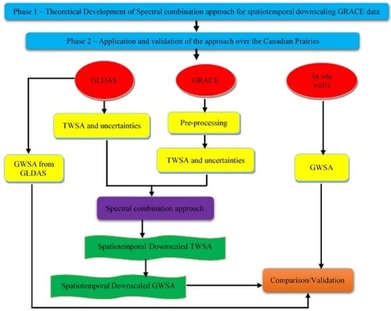
2.2.2. Validation of the Approach

Based on the information given in Section 2.1, 65 active piezometric wells that are distributed across Alberta were used to validate the approach. Figure 2 shows the location of the different wells. It must be noted that groundwater well levels given in height of a water column in a porous aquifer system are not in the same physical unit as GWS variations (total water mass). We converted height of a water column to equivalent water layer thickness (total water mass) by using specific yield ( S y ). Well measurements of different locations are highly heterogenic, and height levels do not have the same ratio to water mass in all locations, because it depends on aquifer storage properties. Therefore, based on geological information about the aquifers from other references, this ration was chosen for Alberta region between 10% and 30% (see Fatolazadeh and Goïta [30]). Two steps were used in the validation process. In the first case, the validation was performed at the location of each well, to determine how its data compare to the estimated GRACE-based GWSA for the corresponding 0.25° × 0.25° grid cell over the entire study period (February to December 2003). Statistical metrics (correlations and root-mean-square error (RMSE)) were calculated at each well location. In the second step of validation, the data for all wells and their corresponding grid cells were combined to evaluate the overall performance of the approach during the study period. In this case, over 21,500 data points were used to compute the statistical metrics (correlation and RMSE).

3. Results

In this section, we first present the estimated errors of GLDAS TWS and GRACE TWS anomalies. Then, the spatiotemporal downscaled results of TWS and GWS anomalies are shown.

3.1. Uncertainty Results of GLDAS and GRACE TWS Anomalies

The estimation of uncertainties is briefly summarized in Section 2.2.1. To simplify the presentation of the paper, we only show results for the 15th day of each month for the purposes of illustration. This period corresponds to the middle of the month, where the availability of spherical harmonic coefficients is the most certain, according to the generation process of average monthly GRACE spherical harmonics data. Figure 4 shows results of GLDAS TWSA uncertainties for the 15th day of each month (February to December 2003) in the study region. For these days, maximum errors of TWSA that are derived from GLDAS do not exceed 15 mm (6% of absolute values). The occurrence of these maxima varies from month to month, and there is no specific pattern. This is due to the seasonal behaviour of hydrological components in the area of the Canadian Prairies with different climate and land cover. Overall, the errors appear more in transition months (i.e., between seasons), particularly March, April, July, and September. Maximum and minimum amplitudes of TWS happen in these months. The smallest errors can be observed in February and December (mostly <3 mm).
Figure 5a shows time series of daily maximum GLDAS TWSA errors across the study region from 1 February to 31 December 2003. Highest maximum errors are found for two periods, i.e., 30 April (75 mm) and 31 May (82 mm). Except for these two periods, daily maximum errors are lower than 50 mm over the whole year. Figure 5a also demonstrates that GLDAS errors are significant in the spring season and lower during the winter (<20 mm). This is because of the accumulation of snow during the winter and water movements due to snowmelt during the spring. Snowmelt produces peaks in soil moisture, runoff, and recharge in groundwater aquifers, explaining the maximum amplitude of TWS changes and eventually their uncertainties. These errors must be accounted for during rigorous downscaling of GRACE data. Figure 5b shows the monthly time series of GRACE TWSA uncertainties from February to December 2003. Maximum errors that were found are of the order of 20 mm (about 7% of absolute values). Figure 5b shows that uncertainties of GRACE, unlike GLDAS, are more stable; they vary in an almost similar range in 2003. As with GLDAS, maximum errors occur in the spring period, i.e., between April and June, while minimum errors are found in the winter period. GRACE determines total TWS of the total column from land surface to the deepest aquifer. This may explain the stability of its errors compared to GLDAS, which uses various data sources subject to their own uncertainties (ground-based, satellite-based observations, land cover data, etc.) in its modelling and assimilation processes.

3.2. Daily Downscaled GRACE TWSA at 0.25°

Figure 6 shows the map of GRACE TWSA after downscaling at a spatiotemporal resolution of daily 0.25° using our spectral combination estimator in the study region. The results are illustrated for the 15th day of each month of 2003. Because our goal was to downscale GRACE TWSA at a daily temporal resolution, we have not shown the monthly GRACE TWSA before downscaling, as their comparisons with daily data are somewhat meaningless. As it can be seen in Figure 6, TWSA exhibits positive variations from February to May, corresponding to snow accumulation in the Prairies (up to March–April) and spring thaw periods (April–May). The important movement of water translates into positive TWSA. Positive values are particularly well marked in the south and southwest, with maxima approaching +60 mm in April and May in southwestern Alberta. The northwestern part of the Prairies remains relatively stable, with values varying around zero. June and July appear as transition months, with generally weak positive to negative TWSA values compared to previous months. TWSA values are negative from August to November all across the Prairies, and the lowest values are found in the south, particularly in September and October (−60 mm). December is also a transition month as snow starts to accumulate, inducing a slight positive effect on TWSA (maximum up to +7 mm).
Downscaled TWSA maps contain various spatial patterns, which cannot be observed in Figure 6, due to the same scale and colour bar being used to present the results. For purposes of illustration, we show spatial variations for selected dates (February, April, June, and October) representing the different seasons (Figure 7). A different colour bar is used in each case to better depict the patterns. The TWSA varied in different ranges from month to month. In February, the maximum and minimum variations were about 40 mm and 5 mm in the southern part of Prairies and the north of Alberta, respectively. In April, the TWSA increased in the southern Prairies by about 10 to 20 mm, and a maximum of 60 mm was registered in southwestern Alberta, while the minimum (about 5 mm) moved to the northern and eastern Prairies. In June, the dynamics were different. Higher values of TWSA were concentrated in Saskatchewan and Alberta, with the maximum remaining in southwestern Alberta, while lowest values of TWSA, with a minimum of −5 mm, occurred in Manitoba. In April 2003, a spring storm brought a heavy snow, as much as ~50 cm, to the southern Alberta (fourth snowiest spring on record). This snowfall continued until end of May, with sometimes 25 to 50 mm of rain. These particular conditions may explain why Southern Alberta experienced maximum TWSA between April and June. The situation was completely different in Manitoba, where the spring was dry with higher temperatures leading to important episodes of fires (Canada’s top ten weather stories in 2003, Canadian Meteorological and Oceanographic Society). It was one of the worst forest fire seasons on record. Consequently, TWSA in the beginning of the spring and partly in the summer was low. In October, the TWSA became negative (between −55 mm and −10 mm) across the Prairies, with the highest values in northern Alberta and Saskatchewan and eastern Manitoba. The pattern seen in October is almost the opposite of what occurs in April.
In Figure 8, we illustrate temporal variations of TWSA from day to day for each month in the pixels with maximum and minimum values. The location of these maxima and minima could change each day. To simplify presentation, we show results for the period between the 10th and the 20th day of each month for these pixels across the study area. As expected, the highest positive values occur in April–May. The maxima rise to approximately 63 mm, thanks to water emanating from snow-melt. The positive trend starts in December forward to May. For this period, even minimum values of TWSA are in a positive range (>2 mm). June and July appear clearly as transition months prior to the period of mixture depletion. For both months, TWSA maxima are positive, while minimum values are in the negative range. The depletion period lies from August to November, with negative values for both maxima and minima. For the year 2003, the lowest values are found in September and October, in the range from −63 mm to −58 mm. In December, the TWSA gradually becomes positive, certainly with the influence of snow accumulation, but the daily maxima do not exceed 7.5 mm. Figure 8 shows clearly that day-to-day temporal variation of TWSA in a month is very low and, indeed, ordering of the maximum monthly values is in perfect agreement from day 10 to day 20 (Kendall’s coefficient of concordance [42]: W = 1.00, Chi-square = 110, df = 10, p < 0.00001). The same level of agreement is demonstrated by the monthly minima (not shown). The variation in values rarely exceeds 1 mm for consecutive days according to the minima and maxima shown in the figure. Even at the scale of the 10 days that are shown, variation in each individual month remains quite low.
Figure 9 shows the time series of average regional daily-downscaled TWSA, monthly original GRACE-derived TWSA prior to downscaling, and daily GLDAS-derived TWSA across the study area. The main motivation behind this figure was to see if the downscaled daily values make sense in comparison to original GRACE monthly estimates and daily hydrological TWSA. The behaviour of daily-downscaled GRACE TWSA follows that of Figure 8. It increases until April, then decreases towards October before increasing again. Monthly original GRACE TWSA and daily GLDAS TWSA also shows similar trends. Comparison between downscaled GRACE TWSA and those extracted from GLDAS and GRACE before downscaling shows high correlation with low RMSE (r = 0.91 with RMSE = 28 mm, and r = 0.98 with RMSE = 15 mm, respectively). However, there is an offset between time-series, which is especially important between August and November. The results showed that there is a shrinkage error (loss of signal amplitude due to the downscaling with the model data). The discrepancy between GLDAS and GRACE may be due to the lack of the surface water component in the GLDAS hydrological model. Dash lines in this figure also indicate that seasonal minimum converges on mid-September 2003, regardless of whether the original monthly data or the downscaled estimates are used.

3.3. Daily Downscaled GRACE GWSA at 0.25°

To extract downscaled GWSA, values of soil moisture, snow water equivalent, and canopy water from GLDAS model were subtracted from the downscaled GRACE TWSA. The approach is explained in Section 2.2.1. Figure 10 shows the maps of GRACE GWSA after downscaling at spatiotemporal resolution of daily 0.25° using the proposed spectral combination estimator over the study area. The results are illustrated for the 15th day of each month of 2003, as is shown in Figure 6. GWSA follows patterns similar to TWSA, which is shown in Figure 6. It is almost positive from the beginning of the year to May, where the maximum values are reached (about 95 mm), particularly in southwestern Alberta. Here also, June and July appear as transition months, but with slightly different patterns. Indeed, GWSA remains mostly positive in June in southern Alberta and in Saskatchewan, but the positive pattern in July is concentrated only in Saskatchewan, especially in the north. From August to December, GWSA is mostly in the negative range, with the lowest values occurring in August to October in the mid-southern regions of the three provinces (about −100 mm). Substantial use of groundwater during those periods may contribute to the depletion seen in Figure 10.
To better capture the spatial patterns of GWSA, we illustrate examples for selected dates representing the different seasons in Figure 11, as we did with TWSA in Figure 7. In February, the positive values had a greater range of variation compared to the corresponding TWSA. The maximum variations were observed in southern Saskatchewan and a minimum in northern Alberta (about 42 mm and 5 mm, respectively). In April, the maximum GWS variations were observed in the southern Alberta, while the minima can be seen along the northeastern boundary of Manitoba bordering Hudson Bay, i.e., about −5 mm. In June, positive GWS variations were obtained in southern Alberta and Saskatchewan (with about 30 mm), compared to the negative values that occurred in most of the northern parts of the Prairies. Overall, the GWSA started to decrease from June. It reached its lowest values in October, with the minimum occurring in the Palliser Triangle (about −62 mm), which is centred on the southernmost part of Alberta and Saskatchewan.
In Figure 12, we examine day-to-day variation of the downscaled GWSA in the pixels with the maximum and minimum values over the study area for each month. As was the case for TWSA, locations of these pixels could change each day. To simplify presentation, we only show the maximum and minimum values of these pixels for the period between the 10th and 20th day of each month, as we did for TSWA (Figure 8). Accordingly, the maxima occur between April and May; the highest value that was found in the 10-day period is 96.5 mm. The minima appear in September to October; the lowest value that was found in the period shown is −102 mm on 18 October. Overall, maximum GWSA is positive from February to July. The values remain generally positive from August to December, but are lower and even negative for a few days, especially in September. The variability of GWSA for consecutive days is summarized in Figure 12 for the period shown. The colour differences observed in each row of the figure illustrate this variability. The patterns that can be seen are different from those of TWSA in Figure 8, where the colours occur in discrete homogeneous bands. The observed heterogeneity in the distribution of the colour bands means that GWSA has greater dynamic variation than does TWSA, but ordering of the former’s respective maximum and minimum values remained strongly concordant from day 10 to day 20 (Maxima: W = 0.9102, Chi-square = 100.12, df = 10, p < 0.00001; minima: W = 0.9097, Chi-square = 100.07, df = 10, p < 0.00001). For example, the maximum GWSAs that were found to vary from 54.4 mm to 96.4 mm, while variation ranged from −98.9 mm to −56.2 mm for the minima in the 10-day period in May 2003. In contrast to TWSA, where day-to-day variation was ~1 mm within a month, variation in GWSA could be substantial (up to 14 mm for maxima, or 32 mm for minima).
Figure 13 shows the time series of average regional daily-downscaled GWSA, monthly original GRACE derived GWSA before downscaling, and daily GLDAS-derived GWSA across the study area. The behaviour of daily-downscaled GRACE GWSA follows Figure 12, with obvious seasonal variations characterized by higher values in the spring, and the lowest in the fall (September and October). Monthly original GRACE GWSA and daily GLDAS GWSA also show similar trends. A comparison between downscaled GRACE TWSA and those extracted from GLDAS and GRACE before downscaling shows high correlation with low RMSE (r = 0.91 with RMSE = 12 mm, and r = 0.85 with RMSE = 29 mm, respectively). The offset between monthly data and downscaled results is particularly important over the period with higher GWSA values. The GWS results obtained here confirm the shrinkage error due to the downscaling process.

3.4. Validation of the Results with In Situ Wells

As explained in Section 2.2.2, 65 wells were used to validate the downscaled GWSA. Statistical metrics (Pearson correlations and RMSE) are presented in Table 1. For the first validation performed at the location of each well, all correlations that were found are significant at 95% confidence level (p < 10−16), with values ranging between r = 0.43 and r = 0.92. More precisely, the correlation ranges between 0.40 and 0.50 for only three wells (about 5% of total), between 0.50 and 0.60 for 10 wells (about 15%), between 0.60 and 0.70 for nine wells (14%), between 0.70 and 0.80 for 16 wells (24%), between 0.80 and 0.90 for 25 wells (39%) and, lastly, between 0.90 and 1.00 for two wells (~3%). In terms of RMSE, the values range from about 10.6 mm to 41.8 mm. They are less than 30 mm for 74% of the well locations. The significant and consistent results found across wells demonstrate a convincing performance for the proposed daily downscaling method.
In the second validation, all data from all individual grid cells at daily 0.25° spatiotemporal resolution containing wells during the study period were combined to calculate the relevant statistical metrics, as explained in Section 2.2.2. At this level of comparison, 21,710 data points were used (334 days, from 1 February to 31 December multiplied by 65 wells = 21,710 data points). The metrics that were estimated are shown at the bottom of Table 1. The overall Pearson correlation between the estimated GWSAs at daily 0.25° spatiotemporal resolution and corresponding in-situ wells during the study period is 0.73 (p < 10−16). The RMSE that was estimated is 23.1 mm. Based on these metrics, we consider that the proposed approach provides convincing results, showing its potential for better spatial and temporal resolution during GWSA retrieval.
For the purposes of illustration, we show the daily time series for both estimated GWSA at 0.25° and the corresponding in-situ well data (Figure 14). Five examples are shown for five selected basins in Alberta. Temporal profiles are shown, together with their scatterplots. The trends and correspondence can be easily seen in each case.

4. Discussion

We have proposed an approach that considers both uncertainties attached to GRACE and GLDAS data, to downscale TWSA simultaneously at a spatial resolution of 0.25° and a temporal resolution of one day. Groundwater anomalies are then derived from the downscaled TWSA. As a reminder, GRACE TWSA data are actually available at a spatial resolution of 1° (theoretically 3°) and a temporal resolution of one month. Taking into account the uncertainties is crucial to the success of the proposed spectral combination method. In principle, the approach could be used with any hydrological model, as long as terrestrial water storage can be computed using its output fields. GLDAS was used in this study, and TWSA was computed using the sum of its water components (soil moisture, snow, among others). Yet, it should be noted that a major limitation of using GLDAS is the lack of the surface water component. During the application of the method to derive downscaled GWSA, we neglected this variable, based on our previous studies that indicate that the surface water component is negligible over most parts of the Canadian Prairies [30], particularly over the Province of Alberta, where the downscaled GWSAs were validated.
The proposed estimator transforms the high frequencies of GLDAS to spherical harmonic coefficients, filters them, and combines them optimally with low frequency GRACE data. It may be possible to attain maximum degree and order of 720 in the spherical harmonic analysis of GLDAS, considering the spatial resolution of its output fields (0.25°). However, taking into account the presence of potential errors in very low frequencies of GLDAS in the computational processes [43], we limited maximum degree and order to 360. Figure 5a indicates uncertainties that were computed for the GLDAS LSM model. It shows some error peaks that may be due to the inherent input parameters, given that GLDAS uses various sources of data, including remote sensing and ground-based observations, each having its own uncertainties (e.g., Gruber et al. [44] for remotely sensed soil moisture products). Additional uncertainties may be related to the GLDAS model structure itself [45]. The proposed approach is not able to distinguish between the uncertainties related to the spatial and temporal dimensions in the end products derived from the spatiotemporal downscaling. This weakness will be addressed in future studies.
Given that groundwater is a critical water component in the Canadian Prairies compared to other parts of the country, we chose to evaluate the proposed daily downscaling approach in the semi-arid region. Although TWSA were computed each day from February to December 2003 at a spatial resolution of 0.25°, we limited the validation of daily groundwater anomalies to the Province of Alberta. This was dictated by the availability of a complete set of daily in-situ piezometric well data for the study period over that province, which was sufficient to validate the method’s potential to generate daily-downscaled GWSA at the desired spatial resolution of 0.25°. Results are illustrated in Figure 4, Figure 6, Figure 7, Figure 10 and Figure 11, showing respective GLDAS uncertainties, TWSA and GWSA maps over the study region for the 15th day of each month of the study period. We chose to illustrate one day per month to simplify the presentation of the paper. Other days could also have been shown as well. The choice of the 15th avoided potential missing data at the beginning and end of the month, as is sometimes the case with GRACE.
Both daily-downscaled TWSA and GWSA show maximum values from April to May, while the minima occur from September to October (Figure 6 and Figure 10). The results of TWSA are consistent with previous findings in the region that used monthly GRACE data at a spatial resolution of 1° [46,47]. The occurrence periods of maxima and minima could be explained by the water budgets. In the Canadian Prairies, precipitation arrives as rain or snow. The accumulation of snow during the winter period on frozen soils (roughly from November to April), and the release of water during spring melt cause important water movements that translate into TWS and GWS variations [48,49,50]. Spring snowmelt occurs with temperatures above 0 °C, thereby leading to a peak in soil moisture, runoff and recharge of groundwater aquifers [51]. Depending upon the year, these processes taking place from mid-March to May could explain the occurrence periods of maximum TWS and GWS changes that were observed in this study (Figure 6 and Figure 10).
Yet, minimum TWS and GWS changes arrive after the growing season, which is usually characterized by high evapotranspiration on the Prairies [46,52]. The manifestation of this water loss can be seen particularly at the beginning of autumn (September and October), where minimum TWSA and GWSA values are found (Figure 6, Figure 7, Figure 8, Figure 9, Figure 10, Figure 11, Figure 12 and Figure 13). Minimum GWSA may be conditioned not only by the level of recharge of aquifers, but also by the pressure incurred by groundwater consumption [38]. In the Canadian Prairies, groundwater is used for domestic needs, agricultural irrigation, and industrial activities.
We further investigated the behaviour of TWSA and GWSA by examining their day-to-day changes (Figure 8 and Figure 12). As can be seen in Figure 8, daily TWS variations appear quite low (mainly <1 mm day-to-day and <2 mm when all days of individual month are considered). This is expected, as TWSA may vary only following extreme meteorological events, such as rainstorms, massive snowfalls, and heavy hurricanes or typhoons [53,54]. Under normal weather conditions, without any major events, short-term changes to TWSA are small. Unlike TWSA, daily GWS changes can be significant, as can be seen in Figure 12. Comparable behaviours have been reported in other studies [55,56,57,58] that showed diurnal fluctuations in groundwater could be high (maxima in the morning and minima in the afternoon). Indeed, temporal variations of groundwater and streamflow may occur on two separate timescales, i.e., long-term changes (seasonal and inter-annual variability) and short-term variations (daily or subdaily fluctuations) [57]. Many factors could explain the diurnal changes in GWSA, including characteristics of soils and aquifers (shallow, deep, confined, unconfined), temperature, atmosphere pressure, and water management activities, among others [57,59,60].
Comparisons between the daily 0.25° downscaled TWSA and GWSA and their corresponding original monthly 3° data (Figure 9 and Figure 13) reveal a number of features that could help to improve the approach in the future. First, the general increasing and decreasing trends are roughly similar in terms of seasonal variations. Second, the overall trends are negative for both TWSA and GWSA, based upon daily results or original monthly data. This could be the consequence of the very low precipitation regime of the Prairies in 2003, which was only 38% of a normal year. Indeed, 2003 was the third driest year in 56 years of record keeping, according to Environment and Climate Change Canada (ECCC). Both GWSA and TWSA were affected by these extreme dry conditions. Third, there are stepwise variations in the estimated daily-downscaled TWSA. This variation results from the fact that the downscaling is performed on a month-by-month basis, thereby creating artificial variations at the limits of the months that are much larger than those observed from one day to another. The latter rarely exceed 2 mm, thereby yielding a plateau appearance for each month. This type of appearance is not observed in Figure 13, as GWSA variations are driven, by not only TWSA, but also by the other water components, such as soil moisture and snow. Fourth, varying scale offsets are observed between both daily-downscaled TWSA and GWSA and their corresponding original monthly data. Chen et al. [15] also showed this difference in the scale of TWSA and GWSA before and after downscaling. The scaling problem is due to the downscaling process, in which the estimator tries to find the optimal uncertainties to improve the quality of the observation. This scale difference, together with the stepwise appearance as the vertical step in the estimated daily-downscaled TWSA (Figure 9), will be investigated further in forthcoming studies to improve the approach.
The performance of the proposed spectral combination approach for estimating daily downscaled GWSA was assessed by using data from 65 wells that were distributed across Alberta. Pearson correlation and RMSE were used to evaluate the results. These standard metrics are utilized in most studies [44,47,61,62]. The validation at each individual well location shows significant correlations in all cases at 95% confidence, with r > 0.70 for about 70% of the wells. These results are even better than those found in previous downscale studies at 25° spatial resolution and monthly temporal resolution [24]. Combining all data points during the study period (21,500+ points) shows a strong association between estimated daily-downscaled GWSA and in-situ well GWSA (r = 0.73, p < 10−16). This result confirms the performance of the proposed approach. It is worth noting that about one year of daily in-situ data were used in the assessment, but all seasons that are present in the Prairies are covered, i.e., autumn, winter, spring, and summer.
One of the advantages of our proposed method is its independence in relation to location, time, input data, and other conditions. The approach could be employed with any hydrological model from which TWSA and its uncertainties could be estimated. Spatial and temporal resolution of the hydrological model products will condition the resolution of the approach outputs. In this research, TWSA could be estimated from GLDAS products at 0.25° daily resolution, thereby defining the maximum limits of spatial and temporal resolution that could be achieved in the downscaling process. Our estimator does not require initial inputs compared to approaches, such as artificial neural networks (ANN). The latter also have their own merits and have recently been proposed for the spatial and temporal downscaling of GRACE data [22]. ANN finds the best solution through a learning process by minimizing the error between GRACE observations and the input field as a reference. In contrast, the proposed approach optimally combines low and high frequencies and their uncertainties to downscale TWSA simultaneously, both spatially and temporally. Consequently, the process reduces systematic errors, which may be created in a step-by-step method.

5. Conclusions

In this study, a new approach was introduced and developed for the first time in a joint attempt to retrieve temporally and spatially downscaled terrestrial water storage and groundwater storage anomalies (TWSA and GWSA) using GRACE and GLDAS data. The method was tested over three Canadian provinces of Alberta, Saskatchewan, and Manitoba. The evaluation of GLDAS variable uncertainties using a condition adjustment approach shows that average GLDAS-derived TWSA is about 22 mm for the study period covering February to December 2003, with the lowest values in the winter and the highest in the spring. These uncertainties were used in the newly proposed daily-downscaled TWSA estimator, which is based upon spectral combination theory. The estimator weights spectrally and combines optimally both GRACE and GLDAS harmonic data considering their uncertainties, to retrieve simultaneously daily-spatially downscaled GRACE TWSA at a resolution of 0.25° (compared to the original 3° and monthly time scale). The results are used to estimate downscaled GWSA. According to the downscaled results, maximum values of TWSA and GWSA occur in the spring period (April–May), while minima are found in the autumn (September–October), which is consistent with previous studies on the Canadian Prairies. Overall, day-to-day variations of TWSA are low (about 1 mm), in contrast to GWSA, where they can reach up to 32 mm. Visual analysis of downscaled GWSA maps shows details and variability as expected, indicating that the approach successfully captured high frequencies. The validation of the approach against in situ piezometric wells across Alberta indicated significant correlations at the locations of each well (r > 0.70 for about 70% of the wells), as well as when the daily data of all wells are combined during the study period (r = 0.73). These convincing results confirm the potential of the proposed spatiotemporal estimator using spectral combination theory to downscale GRACE data and retrieve TWSA and GWSA at a finer spatial resolution on a daily basis. In forthcoming studies, a deeper sensitivity analysis will be undertaken, together with an extensive validation of daily-downscaled GWSA in both Canada and elsewhere.

Author Contributions

Conceptualization, F.F.; Methodology, F.F. and M.E.; Software, F.F.; Validation, F.F.; Formal analysis, F.F.; Writing—original draft, F.F.; Writing—review & editing, M.E., K.G. and S.W.; Visualization, F.F.; Supervision, K.G. and S.W.; Funding acquisition, K.G. All authors have read and agreed to the published version of the manuscript.

Funding

This study was funded by grants from the Natural Sciences and Engineering Research Council of Canada (NSERC Discovery Grant Number: RGPIN-2018-06101; and NSERC Create Grant: 543360-2020).

Data Availability Statement

Spherical harmonic coefficients of release-06 GRACE are available at http://icgem.gfz-potsdam.de/series/01_GRACE/CSR/CSR%20Release%2006, accessed on 1 October 2022. Hydrological variables of the GLDAS_CLSM025_DA1_D 2.2 can be downloaded from https://disc.gsfc.nasa.gov/datasets/GLDAS_CLSM025_DA1_D_2.2/summary?keywords=GLDAS, accessed on 1 October 2022. Information on in-situ observation wells located in Alberta can be downloaded from https://www.alberta.ca/lookup/groundwater-observation-well-network.aspx, accessed on 1 October 2022.

Acknowledgments

We thank all data and product providers, University of Texas at Austin, Natural Resources Canada, and the Goddard Earth Sciences Data and Information Services Center (Greenbelt, MD, USA). We thank the 4 anonymous reviewers whose comments contributed to substantial improvements to the manuscript. W.F.J. Parsons corrected the English.

Conflicts of Interest

The authors declare no conflict of interest.

References

  1. Halloran, L.J.S. Improving groundwater storage change estimates using time-lapse gravimetry with Gravi4GW. Environ. Model. Softw. 2022, 150, 105340. [Google Scholar] [CrossRef]
  2. Liard, J.; Huang, J.; Silliker, J.; Jobin, D.; Wang, S.; Doherty, A. Detecting groundwater storage change using micro-gravity survey in Waterloo Moraine. In Proceedings of the Geohydro 2011, Quebec City, QC, Canada, 28–31 August 2011. [Google Scholar]
  3. Castellazzi, P.; Longuevergne, L.; Martel, R.; Rivera, A.; Brouard, C.; Chaussard, E. Quantitative mapping of groundwater depletion at the water management scale using a combined GRACE/InSAR approach. Remote Sens. Environ. 2018, 205, 408–418. [Google Scholar] [CrossRef]
  4. Li, J.; Wang, S.; Michel, C.; Russell, H.A. Surface deformation observed by InSAR shows connections with water storage change in Southern Ontario. J. Hydrol. Reg. Stud. 2020, 2020, 27. [Google Scholar] [CrossRef]
  5. Tapley, B.D.; Bettadpur, S.; Ries, J.; Thompson, P.F.; Watkins, M.M. GRACE measurements of mass variability in the Earth system. Science 2004, 305, 503–505. [Google Scholar] [CrossRef] [Green Version]
  6. Güntner, A. Improvement of Global Hydrological Models Using GRACE Data. Surv. Geophys. 2008, 29, 375–397. [Google Scholar] [CrossRef] [Green Version]
  7. Wang, S.; Huang, J.; Li, J.; Rivera, A.; McKenney, D.W.; Sheffield, J. Assessment of water budget for sixteen large drainage basins in Canada. J. Hydrol. 2014, 512, 1–15. [Google Scholar] [CrossRef]
  8. Wang, S.; Li, J. Terrestrial water storage climatology for Canada from GRACE satellite observations in 2002–2014. Can. J. Remote Sens. 2016, 42, 190–202. [Google Scholar] [CrossRef]
  9. Chen, J.; Cazenave, A.; Dahle, C.; Llovel, W.; Panet, I.; Pfeffer, J.; Moreira, L. Applications and Challenges of GRACE and GRACE Follow-On Satellite Gravimetry. Surv. Geophys. 2022, 43, 305–345. [Google Scholar] [CrossRef]
  10. Seyoum, W.; Kwon, D.; Milewski, A. Downscaling GRACE TWSA data into high-resolution groundwater level anomaly using machine learning-based models in a glacial aquifer system. Remote Sens. 2019, 11, 824. [Google Scholar] [CrossRef] [Green Version]
  11. Milewski, A.M.; Thomas, M.B.; Seyoum, W.M.; Rasmussen, T.C. Spatial downscaling of GRACE TWSA data to identify spatiotemporal groundwater level trends in the Upper Floridan Aquifer, Georgia, USA. Remote Sens. 2019, 11, 2756. [Google Scholar] [CrossRef]
  12. Ali, S.; Liu, D.; Fu, Q.; Cheema, M.J.M.; Pham, Q.B.; Rahaman, M.d.M.; Dang, T.D.; Anh, D.T. Improving the resolution of GRACE data for spatio-temporal groundwater storage assessment. Remote Sens. 2021, 13, 3513. [Google Scholar] [CrossRef]
  13. Chen, Z.; Zheng, W.; Yin, W.; Li, X.; Zhang, G.; Zhang, J. Improving the spatial resolution of GRACE-derived terrestrial water storage changes in small areas using the Machine Learning Spatial Downscaling Method. Remote Sens. 2021, 13, 4760. [Google Scholar] [CrossRef]
  14. He, H.; Yang, K.; Wang, S.; Petrosians, H.A.; Liu, M.; Li, J.; Marcato, J.J.; Goncalves, W.N.; Wang, L.; Li, J. Deep learning approaches to spatial downscaling of GRACE Terrestrial Water Storage Products using EALCO Model over Canada. Can. J. Remote Sens. 2021, 47, 657–675. [Google Scholar] [CrossRef]
  15. Chen, L.; He, Q.; Liu, K.; Li, J.; Jing, C. Downscaling of GRACE-derived groundwater storage based on the Random Forest model. Remote Sens. 2019, 11, 2979. [Google Scholar] [CrossRef] [Green Version]
  16. Zuo, J.; Xu, J.; Chen, Y.; Li, W. Downscaling simulation of groundwater storage in the Tarim River Basin in Northwest China based on GRACE data. Phys. Chem. Earth 2021, 123, 103042. [Google Scholar] [CrossRef]
  17. Lavado, C.J.; Maneta, M.; Schnabel, S. Prediction of near-surface soil moisture at large scale by digital terrain modeling and neural networks. Environ. Monit. Assess. 2006, 121, 213–232. [Google Scholar] [CrossRef]
  18. Seyoum, W.M.; Milewski, A.M. Improved methods for estimating local terrestrial water dynamics from GRACE in the Northern High Plains. Adv. Water Resour. 2017, 110, 279–290. [Google Scholar] [CrossRef]
  19. Miro, M.; Famiglietti, J. Downscaling GRACE remote sensing datasets to high-resolution groundwater storage change maps of California’s Central Valley. Remote Sens. 2018, 10, 143. [Google Scholar] [CrossRef] [Green Version]
  20. Shang, Q.; Liu, X.; Deng, X.; Zhang, B. Downscaling of GRACE datasets based on relevance vector machine using InSAR time series to generate maps of groundwater storage changes at local scale. J. Appl. Remote Sens. 2019, 13, 048503. [Google Scholar] [CrossRef]
  21. Sahour, H.; Sultan, M.; Vazifedan, M.; Abdelmohsen, K.; Karki, S.; Yellich, J.A.; Gebremichael, E.; Alshehri, F.; Elbayoumi, T.M. Statistical applications to downscale GRACE-derived terrestrial water storage data and to fill temporal gaps. Remote Sens. 2020, 12, 533. [Google Scholar] [CrossRef]
  22. Zhong, D.; Wang, S.; Li, J. Spatiotemporal downscaling of GRACE Total Water Storage using Land Surface Model outputs. Remote Sens. 2021, 13, 900. [Google Scholar] [CrossRef]
  23. Wilby, R.L.; Charles, S.P.; Zorita, E.; Timbal, B.; Whetton, P.; Mearns, L.O. Guidelines for Use of Climate Scenarios Developed from Statistical Downscaling Methods. Task Group of Data and Scenario Support for Impacts and Climate Analysis (TGICA). Intergovernmental Panel on Climate Change. 2004. Available online: http://www.ipcc-data.org/guidelines/dgm_no1_v1_10-2003.pdf (accessed on 20 August 2017).
  24. Fatolazadeh, F.; Eshagh, M.; Goïta, K. New spectro-spatial downscaling of terrestrial and groundwater storage variations estimated by GRACE models. J. Hydrol. 2022, 615, 128635. [Google Scholar] [CrossRef]
  25. Sjöberg, L.E. Least squares combination of satellite harmonics and integral formulas in physical geodesy. Gerlands Beitr Geophys. 1980, 89, 371–377. [Google Scholar]
  26. Sjöberg, L.E. Least squares combination of satellite and terrestrial data in physical geodesy. Ann. Geophys. 1981, 37, 25–30. [Google Scholar]
  27. Wenzel, H.G. Geoid computation by least squares spectral combination using integral kernels. In Proceedings of the International Association of Geodesy (IAG), Tokyo, Japan, 7–20 May 1982; pp. 438–453. [Google Scholar]
  28. Eshagh, M. Spectral combination of spherical gradiometric boundary-value problems: A theoretical study. Pure Appl. Geophys. 2012, 169, 2201–2215. [Google Scholar] [CrossRef]
  29. Cheng, M.; Ries, J.C.; Tapley, B.D. Variations of the Earth’s figure axis from satellite laser ranging and GRACE. J. Geophys. Res. 2011, 116, B01409. [Google Scholar] [CrossRef] [Green Version]
  30. Fatolazadeh, F.; Goïta, K. Reconstructing groundwater storage variations from GRACE observations using a new Gaussian-Han-Fan (GHF) smoothing approach. J. Hydrol. 2022, 604, 127234. [Google Scholar] [CrossRef]
  31. Kromm, D.E. Water conservation in the irrigated prairies of Canada and the United States. Can. Water Resour. J. 1993, 18, 451–458. [Google Scholar] [CrossRef]
  32. Gan, T.Y. Reducing vulnerability of water resources of Canadian Prairies to potential droughts and possible climatic warming. Water Resour. Manag. 2000, 14, 111–135. [Google Scholar] [CrossRef]
  33. Larocque, M.; Broda, S. Groundwater-surface water interactions in Canada. Can. Water Resour. J. 2016, 41, 451–454. [Google Scholar] [CrossRef] [Green Version]
  34. Long, D.; Scanlon, B.R.; Longuevergne, L.; Sun, A.Y.; Fernando, D.N.; Save, H. GRACE satellite monitoring of large depletion in water storage in response to the 2011 drought in Texas. Geophys. Res. Lett. 2013, 40, 3395–3401. [Google Scholar] [CrossRef] [Green Version]
  35. Singh, A.K.; Jasrotia, A.S.; Taloor, A.K.; Kotlia, B.S.; Kumar, V.; Roy, S.; Ray, P.K.C.; Singh, K.K.; Singh, A.K.A.; Sharma, A.K. Estimation of quantitative measures of total water storage variation from GRACE and GLDAS-NOAH satellites using geospatial technology. Quat. Int. 2017, 444, 191–200. [Google Scholar] [CrossRef]
  36. Bhanja, S.N.; Zhang, X.; Wang, J. Estimating long-term groundwater storage and its controlling factors in Alberta, Canada. Hydrol. Earth Syst. Sci. 2018, 22, 6241–6255. [Google Scholar] [CrossRef] [Green Version]
  37. Feng, W.; Shum, C.; Zhong, M.; Pan, Y. Groundwater storage changes in China from satellite gravity: An overview. Remote Sens. 2018, 10, 674. [Google Scholar] [CrossRef] [Green Version]
  38. Chen, H.; Zhang, W.; Nie, N.; Guo, Y. Long-term groundwater storage variations estimated in the Songhua River Basin by using GRACE products, Land Surface Models, and in-situ observations. Sci. Total Environ. 2019, 649, 372–387. [Google Scholar] [CrossRef]
  39. Frappart, F.; Papa, F.; Güntner, A.; Tomasella, J.; Pfeffer, J.; Ramillien, G.; Emilio, T.; Schietti, J.; Seoane, L.; da Silva Carvalho, J.; et al. The spatio-temporal variability of groundwater storage in the Amazon River Basin. Adv. Water Resour. 2019, 124, 41–52. [Google Scholar] [CrossRef] [Green Version]
  40. Rateb, A.; Scanlon, B.R.; Pool, D.R.; Sun, A.; Zhang, Z.; Chen, J.; Clark, B.; Faunt, C.C.; Haugh, C.J.; Hill, M.; et al. Comparison of groundwater storage changes from GRACE satellites with monitoring and modeling of major U.S. aquifers. Water Resour. Res. 2020, 56, e27556. [Google Scholar] [CrossRef]
  41. Wang, S.; Liu, H.; Yu, Y.; Zhao, W.; Yang, Q.; Liu, J. Evaluation of groundwater sustainability in the arid Hexi Corridor of Northwestern China, using GRACE, GLDAS and measured groundwater data products. Sci. Total Environ. 2020, 705, 135829. [Google Scholar] [CrossRef]
  42. Field, A.P. Kendall’s Coefficient of Concordance. In Wiley StatsRef: Statistics Reference Online; John Wiley & Sons, Inc.: Hoboken, NJ, USA, 2014. [Google Scholar] [CrossRef]
  43. Lu, Y.; Hsu, H.T.; Jiang, F.Z. The regional geopotential model to degree and order 720 in China. In Geodesy Beyond 2000; Schwarz, K.P., Ed.; International Association of Geodesy Symposia, 121; Springer: Berlin/Heidelberg, Germany, 2000. [Google Scholar] [CrossRef]
  44. Gruber, A.; De Lannoy, G.; Albergel, C.; Al-Yaari, A.; Brocca, L.; Calvet, J.-C.; Colliander, A.; Cosh, M.; Crow, W.; Dorigo, W.; et al. Validation practices for satellite soil moisture retrievals: What are (the) errors? Remote Sens. Environ. 2020, 244, 111806. [Google Scholar] [CrossRef]
  45. Qi, W.; Liu, J.; Yang, H.; Zhu, X.; Tian, Y.; Jiang, X.; Huang, X.; Feng, L. Large uncertainties in runoff estimations of GLDAS versions 2.0 and 2.1 in China. Earth Space Sci. 2020, 7, e2019EA000829. [Google Scholar] [CrossRef]
  46. Wang, S.; Yang, Y.; Luo, Y.; Rivera, A. Spatial and seasonal variations in evapotranspiration over Canada’s landmass. Hydrol. Earth Syst. Sci. 2013, 17, 3561–3575. [Google Scholar] [CrossRef] [Green Version]
  47. Fatolazadeh, F.; Goïta, K. Mapping terrestrial water storage changes in Canada using GRACE and GRACE-FO. Sci. Total Environ. 2021, 779, 146435. [Google Scholar] [CrossRef] [PubMed]
  48. Vincent, L.A.; Zhang, X.; Mekis, É.; Wan, H.; Bush, E.J. Changes in Canada’s climate: Trends in indices based on daily temperature and precipitation data. Atmos.-Ocean 2018, 56, 332–349. [Google Scholar] [CrossRef] [Green Version]
  49. Bahrami, A.; Goïta, K.; Magagi, R. Analysing the contribution of snow water equivalent to the terrestrial water storage over Canada. Hydrol. Process. 2020, 34, 175–188. [Google Scholar] [CrossRef]
  50. Li, Z.; Wang, S. Water yield variability and response to climate change across Canada. Hydrol. Sci. J. 2021, 66, 1169–1184. [Google Scholar] [CrossRef]
  51. Whitfield, P.H.; Cannon, A.J. Recent Variations in Climate and Hydrology in Canada. Can. Water Resour. J. 2000, 25, 19–65. [Google Scholar] [CrossRef]
  52. Ireson, A.; Barr, A.; Johnstone, J.; Mamet, S.; van der Kamp, G.; Whitfield, C.; Michel, N.L.; North, R.L.; Westbrook, C.J.; DeBeer, C. The changing water cycle: The Boreal Plains ecozone of Western Canada. Wiley Interdiscip. Rev. Water 2015, 2, 505–521. [Google Scholar] [CrossRef]
  53. Jiang, Z.S.; Hsu, Y.J.; Yuan, L.G.; Huang, D.F. Monitoring time-varying terrestrial water storage changes using daily GNSS measurements in Yunnan, southwest China. Remote Sens. Environ. 2021, 254, 112249. [Google Scholar] [CrossRef]
  54. Liu, B.; Yu, W.; Dai, W.; Xing, X.; Kuang, C. Estimation of Terrestrial Water Storage Variations in Sichuan-Yunnan Region from GPS Observations Using Independent Component Analysis. Remote Sens. 2022, 14, 282. [Google Scholar] [CrossRef]
  55. Gribovszki, Z.; Kalicz, P.; Kucsara, M. Streamflow characteristics of two forested catchments in Sopron Hills. Acta Silv. Lignaria Hung. 2006, 2, 81–92. [Google Scholar]
  56. Gribovszki, Z.; Kalicz, P.; Szilágyi, J.; Kucsara, M. Riparian zone evapotranspiration estimation from diurnal groundwater level fluctuations. J. Hydrol. 2008, 349, 6–17. [Google Scholar] [CrossRef]
  57. Gribovszki, Z.; Szilágyi, J.; Kalicz, P. Diurnal fluctuations in shallow groundwater levels and streamflow rates and their interpretation—A review. J. Hydrol. 2010, 385, 371–383. [Google Scholar] [CrossRef] [Green Version]
  58. Wu, L.; Gomez-Velez, J.D.; Krause, S.; Wörman, A.; Singh, T.; Nützmann, G.; Lewandowski, J. How daily groundwater table drawdown affects the diel rhythm of hyporheic exchange. Hydrol. Earth Syst. Sci. 2021, 25, 1905–1921. [Google Scholar] [CrossRef]
  59. Nagy, V.I. Hidrológia (Hydrology); Tankönyvkiadó: Budapest, Hungary, 1965. [Google Scholar]
  60. Juhász, J. Hidrogeológia (Hydrogeology); Akadémiai kiadó: Budapest, Hungary, 2002. (In Hungarian) [Google Scholar]
  61. Bi, H.; Ma, J. Evaluation of simulated soil moisture in GLDAS using in-situ measurements over the Tibetan Plateau. In Proceedings of the 2015 IEEE International Geoscience and Remote Sensing Symposium (IGARSS), Milan, Italy, 26–31 July 2015; pp. 4825–4828. [Google Scholar] [CrossRef]
  62. Wang, W.; Cui, W.; Wang, X.; Chen, X. Evaluation of GLDAS-1 and GLDAS-2 forcing data and Noah model simulations over China at the monthly scale. J. Hydrometeorol. 2016, 17, 2815–2833. [Google Scholar] [CrossRef]
Figure 1. Ground track of the GRACE satellite mission in the periods of 1-day (Left panel), 1-week (middle panel), and 1-month (right panel) (plotted using satellite scenario viewer, Matlab Trial).
Remotesensing 14 05991 g001
Figure 2. Distribution of 65 piezometric wells under study in Alberta (red dots), covering five Canadian river basins (1: Peace-Athabasca, 2: Churchill, 3: North Saskatchewan, 4: South Saskatchewan, 5: Missouri).
Remotesensing 14 05991 g002
Figure 3. Technical flowchart for the spatiotemporal downscaling of GRACE TWS and GWS changes.
Remotesensing 14 05991 g003
Figure 4. Estimated uncertainties of GLDAS TWS anomalies on the 15th day of each month between February and December 2003 [mm].
Remotesensing 14 05991 g004
Figure 5. (a) Daily time series of maximum GLDAS TWSA uncertainties over the study region, (b) Monthly time series of GRACE TWSA uncertainties over the study region, between February and December 2003 [mm].
Remotesensing 14 05991 g005
Figure 6. GRACE terrestrial water storage anomalies (TWSA) after downscaling on the 15th day of each month between February and December 2003 [mm].
Remotesensing 14 05991 g006
Figure 7. GRACE terrestrial water storage anomalies (TWSA) after downscaling on the 15th day of each selected month with separate colour bar ranges [mm].
Remotesensing 14 05991 g007
Figure 8. Daily fluctuations of GRACE terrestrial water storage anomalies (TWSA) in different locations (pixels) after downscaling between the 10th and 20th day of each month from February to December 2003 [mm].
Remotesensing 14 05991 g008
Figure 9. Daily time series of downscaled GRACE TWSA (black colour) vs. monthly time series of original GRACE TWSA before downscaling (blue colour), across study area from February to December 2003 [mm]. Dash lines show the seasonal trend.
Remotesensing 14 05991 g009
Figure 10. Downscaled GRACE groundwater storage anomalies (GWSA) over the study area on the 15th day of each month between February and December 2003 [mm].
Remotesensing 14 05991 g010
Figure 11. Downscaled GRACE groundwater storage anomalies (GWSA) over the study area on the 15th day of each selected month with separate colour bar ranges [mm].
Remotesensing 14 05991 g011
Figure 12. Daily fluctuation of GRACE groundwater storage anomalies (GWSA) in different locations (pixels) after downscaling between the 10th and 20th day of each month between February and December 2003 [mm].
Remotesensing 14 05991 g012
Figure 13. Daily time series of downscaled GRACE GWSA (black colour), vs. monthly time- series of original GRACE GWSA before downscaling (blue colour), across study area from February to December 2003 [mm]. Dash lines show the seasonal trend.
Remotesensing 14 05991 g013
Figure 14. Time series (left panels) and scatter plots (right panels) of groundwater storage anomaly (GWSA) temporal variations from daily downscaled GRACE compared to five different daily piezometric wells (latitudes and longitudes: 55.2935, −118.461; 54.5596, −111.589; 49.1039, −110.251; 52.0117, −114.215; and 53.3876, −112.829, respectively) over the selected river basins in Alberta from February to December 2003 [mm].
Remotesensing 14 05991 g014
Table 1. Correlations (r) and RMSEs [mm] between our downscaled groundwater storage anomalies (GWSA) and each piezometric well. All correlations are significant (p < 10−16).
Well Latitude (degree)Well Longitude (degree)r with Our GWSARMSE with Our GWSAWell Latitude (degree)Well Longitude (degree)r with Our GWSARMSE with Our GWSA
57.5193−111.4040.5210.5849.3784−112.2030.5738.72
53.5889−114.9960.7523.3049.0787−111.3330.8237.70
52.6254−114.0530.7327.1649.5236−110.2180.8132.81
53.5836−114.1080.8422.1649.2376−111.3510.8637.72
52.0061−111.2680.8825.9149.4722−110.9680.8135.47
52.0117−114.2150.8829.6949.1039−110.2510.8534.96
52.8649−111.6470.5523.1456.1892−117.9990.7717.67
52.5503−111.9150.8324.2356.1891−117.8210.8517.66
52.6753−111.3220.7924.1856.2466−117.6360.8217.60
52.7874−111.8570.6123.1755.1961−119.3970.7224.28
53.2870−110.0170.6320.1055.3961−119.7370.8623.60
54.5596−111.5890.7116.0155.2935−118.4610.8921.63
52.4212−110.6070.8224.2954.6465−110.5090.7115.28
53.1611−111.7890.7322.1054.0609−110.4080.8417.08
52.7257−110.8480.7423.6254.4728−110.9840.6416.02
51.1073−115.3660.4336.7254.4857−110.6250.7215.80
50.8446−113.4660.7934.6254.6062−110.2520.8115.17
50.1354−112.4940.6136.0054.6209−110.4310.8115.13
51.0085−112.2370.7631.0754.5759−110.8110.6215.39
51.3319−113.6140.8432.6953.8759−112.9750.6119.32
51.1566−111.1900.7529.5152.9683−112.8540.8924.10
50.7972−110.4180.9129.3152.7451−113.9720.4325.42
50.9797−111.7000.5831.2453.3552−113.6640.8122.90
51.9536−111.4450.5126.7653.4102−113.7620.8423.09
51.7889−110.5040.9226.1252.1027−113.4440.6728.40
51.4146−110.1680.5927.3252.6834−113.5950.7527.24
51.5718−110.4740.8526.7352.3175−112.8020.6126.49
49.9583−112.9390.7738.3253.5689−113.8280.5721.60
49.6351−112.7860.5939.5452.9381−113.3650.8924.88
49.1437−111.8900.4839.0658.9796−118.9150.5414.31
49.7570−113.5100.5340.4358.2244−116.0180.7412.78
49.7278−113.2980.6341.7754.0359−114.3970.8119.99
53.3876−112.8290.8821.83
Overall result for our GWSA during study period combining all individual GRACE grid cells containing wells at daily 0.25° spatiotemporal resolution; r = 0.73, RMSE = 23.13 (N = 21,710).
Publisher’s Note: MDPI stays neutral with regard to jurisdictional claims in published maps and institutional affiliations.

