
Classification of Geomorphic Units and Their Relevance for Nutrient Retention or Export of a Large Lowland Padma River, Bangladesh: A NDVI Based Approach

 ,
,  , ,
, ,
Abstract
:1. Introduction
2. Materials and Methods
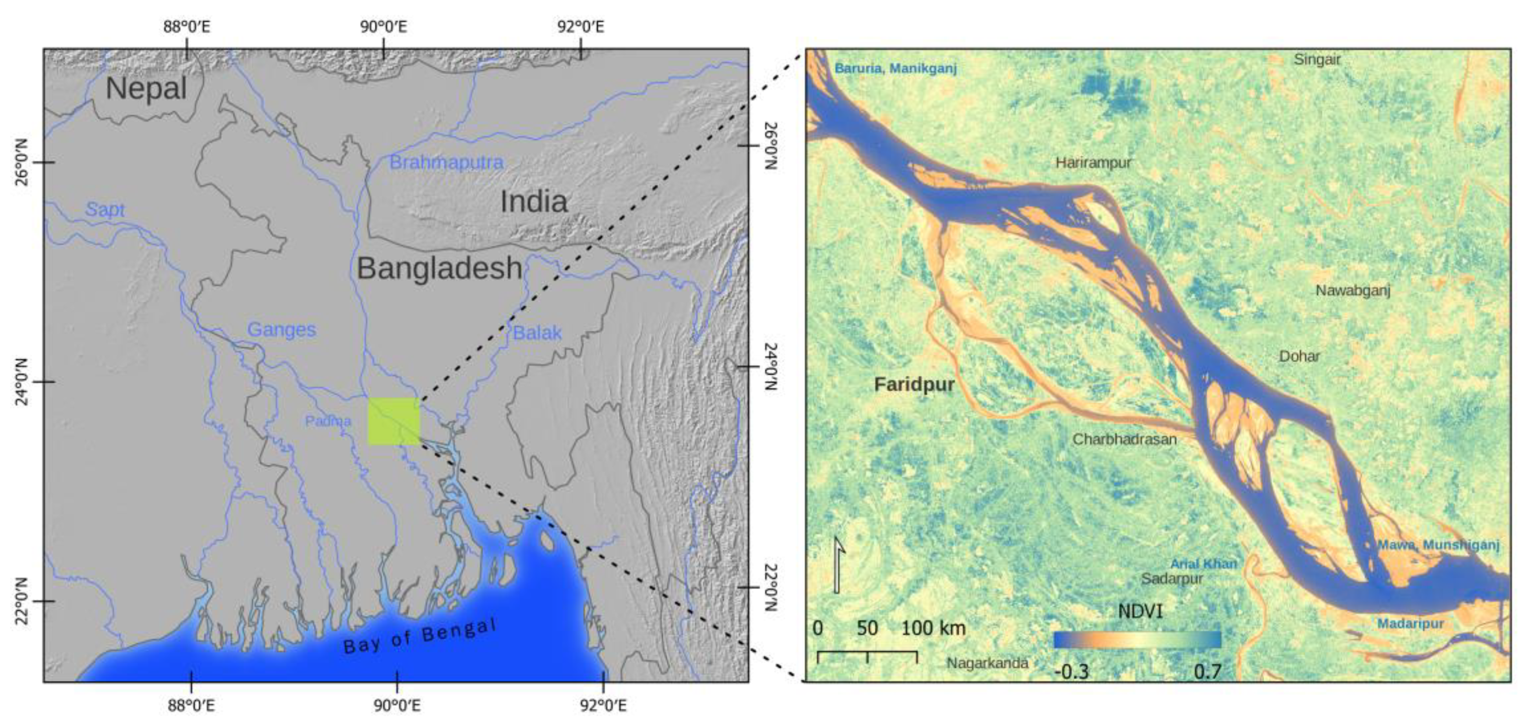
2.1. Study Area
2.2. Geomorphic Classification of GUs
2.3. Seasonal Breakdown and Image Selection
2.4. Image Processing and Analysis
- (a)
- After collection, an atmospheric correction (Dark Object Subtraction, DOS1 [68]) was applied to all the images, using the semi-automatic classification plugin (SCP) tool for QGIS [69]. Mosaics of image pairs were created to cover the study area and, consequently, subsetted to the area of interest using the bands needed to calculate NDVI (Band 4—Red and Band 8—Near-Infrared). After subsetting, the study area was devoid of cloud cover except pre-monsoon 2020. Therefore, for pre-monsoon 2020, four images were used. The first images of May 2020 were used for obtaining cloud-free areas, and after subsetting, the study area was subject to about 5% cloud cover. Using a cloud mask, two images of April 2020 were used to replace the cloud pixels (Figure 3, i–v).
- (b)
- NDVI values range from −1 to 1. Generally, the value approaching −1 represents water; the value varying from −0.1 to 0.1 corresponds to barren areas of sand, and a value greater than 0.1 corresponds to vegetated areas [44,70]. Using visible red (Band 4) and near-infrared (Band 8) bands of Sentinel-2 data, NDVI was calculated and used to classify and analyze images. Based on the NDVI value, GUs were reclassified as land (emergent) and water (submerged). During the conversion from raster to vector, a 10% sieve analysis was performed to remove small polygons of 10 square meters in size from the result (Figure 3, vi–viii).
- (c)
- The study area was delineated based on the image of the dry/winter season (February 2020). Next, all the GUs were classified into units and sub-units based on position and shape, i.e., location of GUs in the main channel or secondary channel and orientation of GUs towards the flow direction. After applying zonal statistics, the end product of the analysis was classified as geomorphic units with counted pixels, mean NDVI value, surface area, perimeter, and maximum distance between two vertices of each polygon (Figure 3, ix–xii).
- (d)
- Inundated GUs or portions of GUs in high flow seasons that emerged during other seasons were termed nutrient retention- or export-relevant geomorphic units (NREGUs). Thus, classified GUs of the monsoon season (high flow) were overlapped with other seasons, to determine the nutrient retention-relevant terrestrial geomorphic units or emergent sediment units. The extraction of NREGUs was based on assumptions that (i) in large rivers, discharge is the main factor regulating nutrient retention or export [8,12,13]; (ii) changes in discharge are responsible for the alteration of water residence time; (iii) the surface area of the channel and water depth are considered determining factors for nutrient retention/export [71,72,73,74,75]; (iv) like the riparian zone, GUs can be flooded annually and enriched with nutrients; and (v) nutrients enter into the system through runoff and sediment supply (Figure 3, xiii–xiv).
- (e)
- The delineation and classification of GUs were first performed for the image of the dry/winter season. Therefore, to keep the exact identification of GUs in the other images, the attributes of the GUs layer were joined by their location, resulting in corresponding GUs in other seasons. Manual cross-checking was done for each GU, other than the dry/winter seasons. Further analysis of GUs was done using zonal statistics, which provided the number of counted pixels, mean, sum, variance, maximum, and minimum value of NDVI in each GU type (emergent and submerged). The polygon shape index from SAGA [76] was used, resulting in different shape index values for each NREGU. The empirical formula of the polygon shape index is:The surface area, perimeter, and polygon shape index of different NREGUs were compared among images of different seasons, to determine the seasonal dynamics (Figure 3, xv–xvi).Polygon Shape Index = Perimeter/[2 × Square Root (Π × Area)]
- (f)
- Geometric errors resulting from vectorizing raster data were corrected using the fix geometrics (FG) tool.
2.5. Field Observation and Morphometric Analysis of NREGUs
3. Results
3.1. Identification of GUs and Seasonal Dynamics
3.2. Seasonal Variation of NREGUs
3.3. Use of NDVI and Shape Indexes for Morphometric Analysis
4. Discussion
5. Conclusions
Author Contributions
Funding
Institutional Review Board Statement
Informed Consent Statement
Data Availability Statement
Conflicts of Interest
References
- Fryirs, K.A.; Brierley, G.J. Geomorphic Analysis of River Systems: An Approach to Reading the Landscape; John Wiley & Sons, Ltd.: Hoboken, NJ, USA, 2013; ISBN 9781741382983. [Google Scholar]
- Elosegi, A.; Pozo, J. Altered Organic Matter Dynamics in Rivers and Streams: Ecological Consequences and Management Implications. Limnetica 2016, 35, 303–322. [Google Scholar] [CrossRef]
- Rinaldi, M.; Belletti, B.; Comiti, F.; Nardi, L.; Bussettini, M.; Mao, L.; Gurnel, A.M. The Geomorphic Units Survey and Classification System (GUS), Deliverable 6.2, Part 4, of REFORM (REstoring Rivers FOR Effective Catchment Management), a Collaborative Project (Large-Scale Integrating Project) Funded by the European Commission within the 7th Framework Programme under Grant Agreement 282656; 2015; Available online: https://www.researchgate.net/publication/283539400_The_Geomorphic_Units_survey_and_classification_System_GUS_Deliverable_62_Part_4_of_REFORM_REstoring_rivers_FOR_effective_catchment_Management_a_Collaborative_project_large-scale_integrating_project_fu (accessed on 25 January 2022).
- Wyrick, J.R.; Pasternack, G.B. Geospatial Organization of Fluvial Landforms in a Gravel-Cobble River: Beyond the Riffle-Pool Couplet. Geomorphology 2014, 213, 48–65. [Google Scholar] [CrossRef] [Green Version]
- Wheaton, J.M.; Fryirs, K.A.; Brierley, G.; Bangen, S.G.; Bouwes, N.; O’Brien, G. Geomorphic Mapping and Taxonomy of Fluvial Landforms. Geomorphology 2015, 248, 273–295. [Google Scholar] [CrossRef]
- Belletti, B.; Rinaldi, M.; Bussettini, M.; Comiti, F.; Gurnell, A.M.; Mao, L.; Nardi, L.; Vezza, P. Geomorphology Characterising Physical Habitats and Fl Uvial Hydromorphology: A New System for the Survey and Classi Fi Cation of River Geomorphic Units. Geomorphology 2017, 283, 143–157. [Google Scholar] [CrossRef]
- Sigleo, A.C.; Frick, W.E. Seasonal Variations in River Discharge and Nutrient Export to a Northeastern Pacific Estuary. Estuar. Coast. Shelf Sci. 2007, 73, 368–378. [Google Scholar] [CrossRef]
- De Klein, J.J.M.; Koelmans, A.A. Quantifying Seasonal Export and Retention of Nutrients in West European Lowland Rivers at Catchment Scale. Hydrol. Processes 2011, 25, 2102–2111. [Google Scholar] [CrossRef]
- Jossette, G.; Leporcq, B.; Sanchez, N. Philippon Biogeochemical Mass-Balances (C, N, P, Si) in Three Large Reservoirs of the Seine Basin (France). Biogeochemistry 1999, 47, 119–146. [Google Scholar] [CrossRef]
- Bernot, M.J.; Dodds, W.K. Nitrogen Retention, Removal, and Saturation in Lotic Ecosystems. Ecosystems 2005, 8, 442–453. [Google Scholar] [CrossRef]
- Grizzetti, B.; Passy, P.; Billen, G.; Bouraoui, F.; Garnier, J.; Lassaletta, L. The Role of Water Nitrogen Retention in Integrated Nutrient Management: Assessment in a Large Basin Using Different Modelling Approaches. Environ. Res. Lett. 2015, 10, 065008. [Google Scholar] [CrossRef]
- Krishna, M.S.; Prasad, M.H.K.; Rao, D.B.; Viswanadham, R.; Sarma, V.V.S.S.; Reddy, N.P.C. ScienceDirect Export of Dissolved Inorganic Nutrients to the Northern Indian Ocean from the Indian Monsoonal Rivers during Discharge Period. Geochim. Cosmochim. Acta 2016, 172, 430–443. [Google Scholar] [CrossRef]
- Best, J. Anthropogenic Stresses on the World’s Big Rivers. Nat. Geosci. 2019, 12, 7–21. [Google Scholar] [CrossRef]
- Eisner, S.; Flörke, M.; Chamorro, A.; Daggupati, P. An Ensemble Analysis of Climate Change Impacts on Streamflow Seasonality across 11 Large River Basins. Clim. Change 2017, 141, 401–417. [Google Scholar] [CrossRef]
- Soar, P.J.; Wallerstein, N.P.; Thorne, C.R. Quantifying River Channel Stability at the Basin Scale. Water 2017, 9, 133. [Google Scholar] [CrossRef] [Green Version]
- Cheng, F.Y.; Basu, N.B. Biogeochemical Hotspots: Role of Small Water Bodies in Landscape Nutrient Processing. Water Resour. Res. 2017, 53, 5038–5056. [Google Scholar] [CrossRef] [Green Version]
- Balestrini, R.; Arese, C.; Delconte, C.A.; Lotti, A.; Salerno, F. Nitrogen Removal in Subsurface Water by Narrow Buffer Strips in the Intensive Farming Landscape of the Po River Watershed, Italy. Ecol. Eng. 2011, 37, 148–157. [Google Scholar] [CrossRef]
- Balestrini, R.; Arese, C.; Delconte, C. Nitrogen Removal in a Freshwater Riparian Wetland: An Example from an Italian Lowland Spring. Internationale Vereinigung für Theoretische und Angewandte Limnologie Verhandlungen 2006, 29, 2217–2220. [Google Scholar] [CrossRef]
- Walton, C.R.; Zak, D.; Audet, J.; Petersen, R.J.; Lange, J.; Oehmke, C.; Wichtmann, W.; Kreyling, J.; Grygoruk, M.; Jabłońska, E.; et al. Wetland Buffer Zones for Nitrogen and Phosphorus Retention: Impacts of Soil Type, Hydrology and Vegetation. Sci. Total Environ. 2020, 727, 138709. [Google Scholar] [CrossRef]
- Masoud, A.A. On the Retrieval of the Water Quality Parameters from Sentinel-3/2 and Landsat-8 OLI in the Nile Delta’s Coastal and Inland Waters. Water 2022, 14, 593. [Google Scholar] [CrossRef]
- Li, S.; Chen, F.; Song, K.; Liu, G.; Tao, H.; Xu, S.; Wang, X.; Wang, Q.; Mu, G. Mapping the Trophic State Index of Eastern Lakes in China Using an Empirical Model and Sentinel-2 Imagery Data. J. Hydrol. 2022, 608, 127613. [Google Scholar] [CrossRef]
- De Stefano, L.G.; Valdivia, A.S.; Gianello, D.; Gerea, M.; Reissig, M.; García, P.E.; García, R.D.; Cárdenas, C.S.; Diéguez, M.C.; Queimaliños, C.P.; et al. Using CDOM Spectral Shape Information to Improve the Estimation of DOC Concentration in Inland Waters: A Case Study of Andean Patagonian Lakes. Sci. Total Environ. 2022, 824, 153752. [Google Scholar] [CrossRef]
- Zeng, S.; Du, C.; Li, Y.; Lyu, H.; Dong, X.; Lei, S.; Li, J.; Wang, H. Monitoring the Particulate Phosphorus Concentration of Inland Waters on the Yangtze Plain and Understanding Its Relationship with Driving Factors Based on OLCI Data. Sci. Total Environ. 2022, 809, 151992. [Google Scholar] [CrossRef] [PubMed]
- Kratzer, S.; Kyryliuk, D.; Edman, M.; Philipson, P.; Lyon, S. Synergy of Satellite, In Situ and Modelled Data for Addressing the Scarcity of Water Quality Information for Eutrophication Assessment and Monitoring of Swedish Coastal Waters. Remote Sens. 2019, 11, 2051. [Google Scholar] [CrossRef] [Green Version]
- Wang, S.; Li, J.; Zhang, B.; Spyrakos, E.; Tyler, A.N.; Shen, Q.; Zhang, F.; Kuster, T.; Lehmann, M.K.; Wu, Y.; et al. Trophic State Assessment of Global Inland Waters Using a MODIS-Derived Forel-Ule Index. Remote Sens. Environ. 2018, 217, 444–460. [Google Scholar] [CrossRef] [Green Version]
- Fay, A.R.; McKinley, G.A. Correlations of Surface Ocean PCO2 to Satellite Chlorophyll on Monthly to Interannual Timescales. Glob. Biogeochem. Cycles 2017, 31, 436–455. [Google Scholar] [CrossRef]
- Binding, C.E.; Greenberg, T.A.; Watson, S.B.; Rastin, S.; Gould, J. Long Term Water Clarity Changes in North America’s Great Lakes from Multi-Sensor Satellite Observations. Limnol. Oceanogr. 2015, 60, 1976–1995. [Google Scholar] [CrossRef]
- De Grandpré, A.; Kinnard, C.; Bertolo, A. Open-Source Analysis of Submerged Aquatic Vegetation Cover in Complex Waters Using High-Resolution Satellite Remote Sensing: An Adaptable Framework. Remote Sens. 2022, 14, 267. [Google Scholar] [CrossRef]
- Wieland, M.; Martinis, S. A Modular Processing Chain for Automated Flood Monitoring from Multi-Spectral Satellite Data. Remote Sens. 2019, 11, 2330. [Google Scholar] [CrossRef] [Green Version]
- Kwak, Y. Nationwide Flood Monitoring for Disaster Risk Reduction Using Multiple Satellite Data. ISPRS Int. J. Geo-Inf. 2017, 6, 203. [Google Scholar] [CrossRef]
- Ahamed, A.; Bolten, J.D. A MODIS-Based Automated Flood Monitoring System for Southeast Asia. Int. J. Appl. Earth Obs. Geoinf. 2017, 61, 104–117. [Google Scholar] [CrossRef] [Green Version]
- Guilhen, J.; al Bitar, A.; Sauvage, S.; Parrens, M.; Martinez, J.-M.; Abril, G.; Moreira-Turcq, P.; Sánchez-Pérez, J.-M. Denitrification and Associated Nitrous Oxide and Carbon Dioxide Emissions from the Amazonian Wetlands. Biogeosciences 2020, 17, 4297–4311. [Google Scholar] [CrossRef]
- Martínez-Espinosa, C.; Sauvage, S.; al Bitar, A.; Green, P.A.; Vörösmarty, C.J.; Sánchez-Pérez, J.M. Denitrification in Wetlands: A Review towards a Quantification at Global Scale. Sci. Total Environ. 2021, 754, 142398. [Google Scholar] [CrossRef] [PubMed]
- Faruque, M.J.; Vekerdy, Z.; Hasan, M.Y.; Islam, K.Z.; Young, B.; Ahmed, M.T.; Monir, M.U.; Shovon, S.M.; Kakon, J.F.; Kundu, P. Monitoring of Land Use and Land Cover Changes by Using Remote Sensing and GIS Techniques at Human-Induced Mangrove Forests Areas in Bangladesh. Remote Sens. Appl. Soc. Environ. 2022, 25, 100699. [Google Scholar] [CrossRef]
- Gameiro, S.; Nascimento, V.; Facco, D.; Sfredo, G.; Ometto, J. Multitemporal Spatial Analysis of Land Use and Land Cover Changes in the Lower Jaguaribe Hydrographic Sub-Basin, Ceará, Northeast Brazil. Land 2022, 11, 103. [Google Scholar] [CrossRef]
- Ge, G.; Zhang, J.; Chen, X.; Liu, X.; Hao, Y.; Yang, X.; Kwon, S.M. Effects of Land Use and Land Cover Change on Ecosystem Services in an Arid Desert-Oasis Ecotone along the Yellow River of China. Ecol. Eng. 2022, 176, 106512. [Google Scholar] [CrossRef]
- Markogianni, V.; Kalivas, D.; Petropoulos, G.P.; Dimitriou, E. Modelling of Greek Lakes Water Quality Using Earth Observation in the Framework of the Water Framework Directive (WFD). Remote Sens. 2022, 14, 739. [Google Scholar] [CrossRef]
- SUHET. Sentinel-2 User Handbook; European Space Agency: Paris, France, 2015; pp. 1–64. [Google Scholar]
- Drusch, M.; del Bello, U.; Carlier, S.; Colin, O.; Fernandez, V.; Gascon, F.; Hoersch, B.; Isola, C.; Laberinti, P.; Martimort, P.; et al. Sentinel-2: ESA’s Optical High-Resolution Mission for GMES Operational Services. Remote Sens. Environ. 2012, 120, 25–36. [Google Scholar] [CrossRef]
- McFeeters, S.K. The Use of the Normalized Difference Water Index (NDWI) in the Delineation of Open Water Features. Int. J. Remote Sens. 1996, 17, 1425–1432. [Google Scholar] [CrossRef]
- Serrano, J.; Shahidian, S.; Marques da Silva, J. Evaluation of Normalized Difference Water Index as a Tool for Monitoring Pasture Seasonal and Inter-Annual Variability in a Mediterranean Agro-Silvo-Pastoral System. Water 2019, 11, 62. [Google Scholar] [CrossRef] [Green Version]
- Didan, K.; Barreto Munoz, A.; Solano, R.; Huete, A. MODIS Vegetation Index User’s Guide (MOD13 Series); University of Arizona: Tucson, AZ, USA, 2015. [Google Scholar]
- Freden, S.C.; Mercanti, E.P.; Becker, M.A. (Eds.) Third Earth Resources Technology Satellite-1 Symposium—Volume 1: Technical Presentations; NASA: Washington, DC, USA, 1974; pp. 309–317. [Google Scholar]
- Japan Association on Remote Sensing. Remote Sensing Note; Nihon Printing Co., Ltd.: Tokyo, Japan, 1993. [Google Scholar]
- Sonam; Jain, V.; Fryirs, K.; Brierley, G. Geomorphic Characterization of a Seasonal River Network in Semi-Arid Western India Using the River Styles Framework. J. Asian Earth Sci. X 2022, 7, 100077. [Google Scholar] [CrossRef]
- Fryirs, K.; Brierley, G. Assemblages of Geomorphic Units: A Building Block Approach to Analysis and Interpretation of River Character, Behaviour, Condition and Recovery. Earth Surf. Processes Landf. 2022, 47, 92–108. [Google Scholar] [CrossRef]
- Han, M.; Brierley, G. Channel Geomorphology and Riparian Vegetation Interactions along Four Anabranching Reaches of the Upper Yellow River. Prog. Phys. Geogr. Earth Environ. 2020, 44, 898–922. [Google Scholar] [CrossRef]
- Boz, B.; Gumiero, B. Nitrogen Removal in an Afforested Riparian Zone: The Contribution of Denitrification Processes. Hydrobiologia 2016, 774, 167–182. [Google Scholar] [CrossRef]
- Gomez-Velez, J.D.; Harvey, J.W.; Cardenas, M.B.; Kiel, B. Denitrification in the Mississippi River Network Controlled by Flow through River Bedforms. Nat. Geosci. 2015, 8, 941–945. [Google Scholar] [CrossRef]
- Tatariw, C.; Chapman, E.L.; Sponseller, R.A.; Mortazavi, B.; Edmonds, J.W. Denitrification in a Large River: Consideration of Geomorphic Controls on Microbial Activity and Community Structure. Ecology 2013, 94, 2249–2262. [Google Scholar] [CrossRef] [PubMed]
- Taramelli, A.; Lissoni, M.; Piedelobo, L.; Schiavon, E.; Valentini, E.; Xuan, A.N.; González-Aguilera, D. Monitoring Green Infrastructure for Natural Water Retention Using Copernicus Global Land Products. Remote Sens. 2019, 11, 1583. [Google Scholar] [CrossRef] [Green Version]
- Piedelobo, L.; Taramelli, A.; Schiavon, E.; Valentini, E.; Molina, J.-L.; Nguyen Xuan, A.; González-Aguilera, D. Assessment of Green Infrastructure in Riparian Zones Using Copernicus Programme. Remote Sens. 2019, 11, 2967. [Google Scholar] [CrossRef] [Green Version]
- Piedelobo, L.; Hernández-López, D.; Ballesteros, R.; Chakhar, A.; del Pozo, S.; González-Aguilera, D.; Moreno, M.A. Scalable Pixel-Based Crop Classification Combining Sentinel-2 and Landsat-8 Data Time Series: Case Study of the Duero River Basin. Agric. Syst. 2019, 171, 36–50. [Google Scholar] [CrossRef]
- Martín-Ortega, P.; García-Montero, L.G.; Sibelet, N. Temporal Patterns in Illumination Conditions and Its Effect on Vegetation Indices Using Landsat on Google Earth Engine. Remote Sens. 2020, 12, 211. [Google Scholar] [CrossRef] [Green Version]
- Kumari, N.; Srivastava, A.; Dumka, U.C. A Long-Term Spatiotemporal Analysis of Vegetation Greenness over the Himalayan Region Using Google Earth Engine. Climate 2021, 9, 109. [Google Scholar] [CrossRef]
- Xue, J.; Su, B. Significant Remote Sensing Vegetation Indices: A Review of Developments and Applications. J. Sens. 2017, 2017, 1353691. [Google Scholar] [CrossRef] [Green Version]
- Marchetti, Z.Y.; Ramonell, C.G.; Brumnich, F.; Alberdi, R.; Kandus, P. Vegetation and Hydrogeomorphic Features of a Large Lowland River: NDVI Patterns Summarizing Fluvial Dynamics and Supporting Interpretations of Ecological Patterns. Earth Surf. Processes Landf. 2020, 45, 694–706. [Google Scholar] [CrossRef]
- Marchetti, Z.Y.; Minotti, P.G.; Ramonell, C.G.; Schivo, F.; Kandus, P. NDVI Patterns as Indicator of Morphodynamic Activity in the Middle Paraná River Floodplain. Geomorphology 2016, 253, 146–158. [Google Scholar] [CrossRef]
- Marchetti, Z.Y.; Latrubesse, E.M.; Pereira, M.S.; Ramonell, C.G. Vegetation and Its Relationship with Geomorphologic Units in the Parana River floodplain, Argentina. J. South Am. Earth Sci. 2013, 46, 122–136. [Google Scholar] [CrossRef]
- Luan, J.; Liu, D.; Zhang, L.; Huang, Q.; Feng, J.; Lin, M.; Li, G. Analysis of the Spatial-Temporal Change of the Vegetation Index in the Upper Reach of Han River Basin in 2000–2016. Proc. Proc. Int. Assoc. Hydrol. Sci. 2018, 379, 287–292. [Google Scholar] [CrossRef] [Green Version]
- Kaplan, G.; Avdan, U. Mapping and Monitoring Wetlands Using Sentinel-2 Satellite Imagery. ISPRS Annals of the Photogrammetry, Remote Sensing and Spatial Information Sciences. In Proceedings of the 2017 4th International GeoAdvances Workshop, Safranbolu, Turkey, 14–15 October 2017; Volume IV-4/W4, pp. 271–277. [Google Scholar]
- Xu, W.; Yang, D.; Li, Y.; Xiao, R. Correlation Analysis of Mackenzie River Discharge and NDVI Relationship. Can. J. Remote Sens. 2016, 42, 292–306. [Google Scholar] [CrossRef]
- NASA Earth Observatory. Available online: https://earthobservatory.nasa.gov/world-of-change/PadmaRiver (accessed on 27 March 2019).
- Sarker, M.H.; Koudstaal, R.; Alam, M. Rivers, Chars and Char Dwellers of Bangladesh. Int. J. River Basin Manag. 2003, 1, 61–80. [Google Scholar] [CrossRef]
- AECOM New Zealand Limited (Ed.) Padma Multipurpose Bridge Design Project: Updated Scheme Design Report for River Training Works; Bangladesh Bridge Authority: Dhaka, Bangladesh, 2010; Volume 1. [Google Scholar]
- Bangladesh Water Development Board. Available online: http://www.hydrology.bwdb.gov.bd/index.php?pagetitle=discharge_data_view&sub2=139&_subid=132&id=134 (accessed on 20 March 2021).
- Billah, M.M. Mapping and Monitoring Erosion-Accretion in an Alluvial River Using Satellite Imagery-The River Bank Changes of The Padma River in Bangladesh. Quaestiones Geographicae 2018, 37, 87–95. [Google Scholar] [CrossRef] [Green Version]
- Moran, M.S.; Jackson, R.D.; Slater, P.N.; Teillet, P.M. Evaluation of Simplified Procedures for Retrieval of Land Surface Reflectance Factors from Satellite Sensor Output. Remote Sens. Environ. 1992, 41, 169–184. [Google Scholar] [CrossRef]
- Congedo, L. Semi-Automatic Classification Plugin: A Python tool for the download and processing of remote sensing images in QGIS. J. Open Source Softw. 2021, 6, 3172. [Google Scholar] [CrossRef]
- Gandhi, G.M.; Parthiban, S.; Thummalu, N.; Christy, A. Ndvi: Vegetation Change Detection Using Remote Sensing and Gis—A Case Study of Vellore District. Procedia Comput. Sci. 2015, 57, 1199–1210. [Google Scholar] [CrossRef] [Green Version]
- Ye, S.; Reisinger, A.J.; Tank, J.L.; Baker, M.A.; Hall, R.O., Jr.; Rosi, E.J.; Sivapalan, M. Scaling Dissolved Nutrient Removal in River Networks: A Comparative Modeling Investigation. Water Resour. Res. 2017, 53, 9623–9641. [Google Scholar] [CrossRef] [Green Version]
- Basu, N.B.; Rao, P.S.C.; Thompson, S.E.; Loukinova, N.V.; Donner, S.D.; Ye, S.; Sivapalan, M. Spatiotemporal Averaging of In-Stream Solute Removal Dynamics. Water Resour. Res. 2011, 47, W00J06. [Google Scholar] [CrossRef] [Green Version]
- Mulholland, A.P.J.; Webster, J.R.; Mulholland, P.J.; Webster, J.R. Nutrient Dynamics in Streams and the Role of J-NABS Nutrient Dynamics in Streams and the Role of J-NABS. J. North Am. Benthol. Soc. 2010, 29, 100–117. [Google Scholar] [CrossRef]
- Seitzinger, S.; Harrison, J.A.; Böhlke, J.K.; Bouwman, A.F.; Lowrance, R.; Peterson, B.; Tobias, C.; van Drecht, G. Denitrification across Landscapes and Waterscapes: A Synthesis. Ecol. Appl. 2006, 16, 2064–2090. [Google Scholar] [CrossRef] [Green Version]
- Alexander, R.B.; Smith, R.A.; Schwarz, G.E. Effect of Stream Channel Size on the Delivery of Nitrogen to the Gulf of Mexico. Nature 2000, 403, 758–761. [Google Scholar] [CrossRef]
- Lang, S.; Blaschke, T. Landschaftsanalyse Mit GIS; utb GmbH: Stuttgart, Germany, 2007; ISBN 9783838583471. [Google Scholar]
- Venables, W.N.; Smith, D.M.; R Development Core Team. An Introduction to R; Notes on R: A Programming Environment for Data Analysis and Graphics; R Development Core Team: Vienna, Austria, 2021. [Google Scholar]
- González del Tánago, M.; Martínez-Fernández, V.; Aguiar, F.C.; Bertoldi, W.; Dufour, S.; García de Jalón, D.; Garófano-Gómez, V.; Mandzukovski, D.; Rodríguez-González, P.M. Improving River Hydromorphological Assessment through Better Integration of Riparian Vegetation: Scientific Evidence and Guidelines. J. Environ. Manag. 2021, 292, 112730. [Google Scholar] [CrossRef]
- Vaughan, I.P.; Diamond, M.; Gurnell, A.M.; Hall, K.A.; Jenkins, A.; Milner, N.J.; Naylor, L.A.; Sear, D.A.; Woodward, G.; Ormerod, S.J. Integrating Ecology with Hydromorphology: A Priority for River Science and Management. Aquat. Conserv. Mar. Freshw. Ecosyst. 2009, 19, 113–125. [Google Scholar] [CrossRef] [Green Version]
- Towfiqul Islam, A.B.M. Assessment of Fluvial Channel Dynamics of Padma River in Northwestern Bangladesh. Univers. J. Geosci. 2016, 4, 41–49. [Google Scholar] [CrossRef]
- Liu, X.; Shi, C.; Zhou, Y.; Gu, Z.; Li, H. Response of Erosion and Deposition of Channel Bed, Banks and Floodplains Towater and Sediment Changes in the Lower Yellow River, China. Water 2019, 11, 357. [Google Scholar] [CrossRef] [Green Version]
- Mahmud, I.H.; Pal, P.K.; Rahman, A.; Yunus, A. A Study on Seasonal Variation of Hydrodynamic Parameters of Padma River. J. Mod. Sci. Technol. 2017, 5, 1–10. [Google Scholar]
- Masotti, I.; Aparicio-Rizzo, P.; Yevenes, M.A.; Garreaud, R.; Belmar, L.; Farías, L. The Influence of River Discharge on Nutrient Export and Phytoplankton Biomass off the Central Chile Coast (33°–37°S): Seasonal Cycle and Interannual Variability. Front. Mar. Sci. 2018, 5, 423. [Google Scholar] [CrossRef]
- Nawfee, S.M.; Dewan, A.; Rashid, T. Integrating Subsurface Stratigraphic Records with Satellite Images to Investigate Channel Change and Bar Evolution: A Case Study of the Padma River, Bangladesh. Environ. Earth Sci. 2018, 77, 89. [Google Scholar] [CrossRef]
- Hossain, M.A.; Gan, T.Y.; Baki, A.B.M. Assessing Morphological Changes of the Ganges River Using Satellite Images. Quat. Int. 2013, 304, 142–155. [Google Scholar] [CrossRef]
- Wampler, P.J. Rivers and Streams-Water and Sediment in Motion. Nat. Educ. Knowl. 2012, 3, 18. [Google Scholar]
- Shields, F.D.; Copeland, R.R.; Klingeman, P.C.; Doyle, M.W.; Simon, A. Design for Stream Restoration. J. Hydraul. Eng. 2003, 129, 575–584. [Google Scholar] [CrossRef]
- Knighton, A.D. Fluvial Forms and Processes: A New Perspective; Edward Arnold Publishers: London, UK, 1998; 383p, ISBN 0340663138. [Google Scholar] [CrossRef] [Green Version]
- Pareta, K.; Pareta, U. Geomorphic Classification and Mapping of Rapti River System Using Satellite Remote Sensing Data. Am. J. Geophys. Geochem. Geosystems 2020, 6, 1–15. [Google Scholar]
- Meshkova, L.V.; Carling, P.A. The Geomorphological Characteristics of the Mekong River in Northern Cambodia: A Mixed Bedrock–Alluvial Multi-Channel Network. Geomorphology 2012, 147–148, 2–17. [Google Scholar] [CrossRef]
- Latrubesse, E.M. Patterns of Anabranching Channels: The Ultimate End-Member Adjustment of Mega Rivers. Geomorphology 2008, 101, 130–145. [Google Scholar] [CrossRef]
- Palta, M.M.; Ehrenfeld, J.G.; Giménez, D.; Groffman, P.M.; Subroy, V. Soil Texture and Water Retention as Spatial Predictors of Denitrification in Urban Wetlands. Soil Biol. Biochem. 2016, 101, 237–250. [Google Scholar] [CrossRef]
- Marton, J.M.; Creed, I.F.; Lewis, D.B.; Lane, C.R.; Basu, N.B.; Cohen, M.J.; Craft, C.B. Geographically Isolated Wetlands Are Important Biogeochemical Reactors on the Landscape. BioScience 2015, 65, 408–418. [Google Scholar] [CrossRef] [Green Version]
- Pribyl, A.L.; Mccutchan, J.H.; Lewis, W.M.; Saunders, J.F., III. Whole-System Estimation of Denitrification in a Plains River: A Comparison of Two Methods. Biogeochemistry 2005, 73, 439–455. [Google Scholar] [CrossRef]
- Wang, W.; Hu, P.; Yang, Z.; Wang, J.; Zhao, J.; Zeng, Q.; Liu, H.; Yang, Q. Prediction of NDVI Dynamics under Different Ecological Water Supplementation Scenarios Based on a Long Short-Term Memory Network in the Zhalong Wetland, China. J. Hydrol. 2022, 608, 127626. [Google Scholar] [CrossRef]
- Liang, S.; Gong, Z.; Wang, Y.; Zhao, J.; Zhao, W. Accurate Monitoring of Submerged Aquatic Vegetation in a Macrophytic Lake Using Time-Series Sentinel-2 Images. Remote Sens. 2022, 14, 640. [Google Scholar] [CrossRef]
- Fu, B.; Burgher, I. Riparian Vegetation NDVI Dynamics and Its Relationship with Climate, Surface Water and Groundwater. J. Arid Environ. 2015, 113, 59–68. [Google Scholar] [CrossRef]
- Khare, S.; Deslauriers, A.; Morin, H.; Latifi, H.; Rossi, S. Comparing Time-Lapse PhenoCams with Satellite Observations across the Boreal Forest of Quebec, Canada. Remote Sens. 2021, 14, 100. [Google Scholar] [CrossRef]
- Yu, L.; Leng, G. Identifying the Paths and Contributions of Climate Impacts on the Variation in Land Surface Albedo over the Arctic. Agric. For. Meteorol. 2022, 313, 108772. [Google Scholar] [CrossRef]
- Munyati, C. Detecting the Distribution of Grass Aboveground Biomass on a Rangeland Using Sentinel-2 MSI Vegetation Indices. Adv. Space Res. 2022, 69, 1130–1145. [Google Scholar] [CrossRef]
- Mia, M.B.; Hasan, T.; Akhter, S.H. Change Detection of Landuse-Landcover in and around Cox’s Bazar-Teknaf Coastal Area of Bangladesh Using Satellite Images. Dhaka Univ. J. Earth Environ. Sci. 2019, 8, 1–9. [Google Scholar] [CrossRef]
- Redhead, J.W.; May, L.; Oliver, T.H.; Hamel, P.; Sharp, R.; Bullock, J.M. National Scale Evaluation of the InVEST Nutrient Retention Model in the United Kingdom. Sci. Total Environ. 2018, 610–611, 666–677. [Google Scholar] [CrossRef]
- Decsi, B.; Vári, Á.; Kozma, Z. The Effect of Future Land Use Changes on Hydrologic Ecosystem Services: A Case Study from the Zala Catchment, Hungary. Biologia Futura 2020, 71, 405–418. [Google Scholar] [CrossRef]
- Piedelobo, L.; Ortega-Terol, D.; del Pozo, S.; Hernández-López, D.; Ballesteros, R.; Moreno, M.; Molina, J.-L.; González-Aguilera, D. HidroMap: A New Tool for Irrigation Monitoring and Management Using Free Satellite Imagery. ISPRS Int. J. Geo-Inf. 2018, 7, 220. [Google Scholar] [CrossRef] [Green Version]
- Yousaf, A.; Khalid, N.; Aqeel, M.; Noman, A.; Naeem, N.; Sarfraz, W.; Ejaz, U.; Qaiser, Z.; Khalid, A. Nitrogen Dynamics in Wetland Systems and Its Impact on Biodiversity. Nitrogen 2021, 2, 13. [Google Scholar] [CrossRef]
- Ma, L.; Xiong, Z.; Yao, L.; Liu, G.; Zhang, Q.; Liu, W. Soil Properties Alter Plant and Microbial Communities to Modulate Denitrification Rates in Subtropical Riparian Wetlands. Land Degrad. Dev. 2020, 31, 1792–1802. [Google Scholar] [CrossRef]
- Kayima, J.K.; Mayo, A.W. Nitrogen Removal Buffer Capacity of the Lubigi Wetland in Uganda. Phys. Chem. Earth Parts A/B/C 2020, 117, 102883. [Google Scholar] [CrossRef]
- Wyrick, J.R.; Senter, A.E.; Pasternack, G.B. Revealing the Natural Complexity of Fluvial Morphology through 2D Hydrodynamic Delineation of River Landforms. Geomorphology 2014, 210, 14–22. [Google Scholar] [CrossRef] [Green Version]


| Macro-Units | Units | Sub-Units | |||
|---|---|---|---|---|---|
| Name | Code | Name | Code | Name | Code |
| Submerged channel units | C S | Main channel | C | - | - |
| Secondary channel | S | - | - | ||
| Emergent sediment units | E | Bank-attached bar | EA | Side bar | SB |
| Mid-channel bar | EC | Longitudinal bar | L | ||
| Transverse bar | T | ||||
| Dry channel | ED | - | - | ||
| Unvegetated bank | EK | - | - | ||
| Water depression | WD | - | - | ||
| In-channel vegetation units | V | Island | VI | - | - |
| Water depression | WD | - | - | ||
| Satellite/Sensor | Acquisition Date | Season | Tile Identifier | Cloud Cover (%) |
|---|---|---|---|---|
| Sentinel 2A/MSI | 19 September 2019 | Monsoon 2019 | 45QYG | 2.64 |
| Sentinel 2A/MSI | 19 September 2019 | Monsoon 2019 | 45QZG | 4.56 |
| Sentinel 2B/MSI | 11 November 2019 | Post-monsoon 2019 | 45QYG | 0 |
| Sentinel 2B/MSI | 11 November 2019 | Post-monsoon 2019 | 45QZG | 0.85 |
| Sentinel 2B/MSI | 11 February 2020 | Dry/Winter 2020 | 45QYG | 0 |
| Sentinel 2B/MSI | 11 February 2020 | Dry/Winter 2020 | 45QZG | 0 |
| Sentinel 2B/MSI | 16 April 2020 | Pre-monsoon 2020 | 45QYG | 0.12 |
| Sentinel 2B/MSI | 16 April 2020 | Pre-monsoon 2020 | 45QZG | 4.17 |
| Sentinel 2B/MSI | 11 May 2020 | Pre-monsoon 2020 | 45QYG | 47.05 |
| Sentinel 2B/MSI | 11 May 2020 | Pre-monsoon 2020 | 45QZG | 52.10 |
| GU | Monsoon | Post-Monsoon | Dry/Winter | Pre-Monsoon | ||||
|---|---|---|---|---|---|---|---|---|
| km2 | % | km2 | % | km2 | % | km2 | % | |
| C&S | 362.58 | 92.6 | 315.0 | 87.53 | 250.88 | 63.52 | 274.75 | 77.0 |
| EA | 0.00 | - | 0.69 | 0.19 | 13.29 | 3.36 | 13.49 | 3.78 |
| EC | 3.78 | 0.96 | 13.25 | 3.68 | 41.43 | 10.49 | 24.1 | 6.76 |
| ED | 0.00 | - | 0.30 | 0.08 | 0.1 | 0.02 | 0.03 | 0.01 |
| EK | 0.00 | - | 0.94 | 0.26 | 0.57 | 0.14 | 0.53 | 0.15 |
| VI | 14.83 | 3.79 | 26.2 | 7.28 | 86.5 | 21.90 | 42.9 | 12.0 |
| WD | 10.34 | 2.64 | 3.48 | 0.97 | 2.2 | 0.56 | 0.98 | 0.28 |
Publisher’s Note: MDPI stays neutral with regard to jurisdictional claims in published maps and institutional affiliations. |
© 2022 by the authors. Licensee MDPI, Basel, Switzerland. This article is an open access article distributed under the terms and conditions of the Creative Commons Attribution (CC BY) license (https://creativecommons.org/licenses/by/4.0/).
Share and Cite
Gani, M.A.; Kwast, J.v.d.; McClain, M.E.; Gettel, G.; Irvine, K. Classification of Geomorphic Units and Their Relevance for Nutrient Retention or Export of a Large Lowland Padma River, Bangladesh: A NDVI Based Approach. Remote Sens. 2022, 14, 1481. https://0-doi-org.brum.beds.ac.uk/10.3390/rs14061481
Gani MA, Kwast Jvd, McClain ME, Gettel G, Irvine K. Classification of Geomorphic Units and Their Relevance for Nutrient Retention or Export of a Large Lowland Padma River, Bangladesh: A NDVI Based Approach. Remote Sensing. 2022; 14(6):1481. https://0-doi-org.brum.beds.ac.uk/10.3390/rs14061481
Chicago/Turabian StyleGani, Md Ataul, Johannes van der Kwast, Michael E. McClain, Gretchen Gettel, and Kenneth Irvine. 2022. "Classification of Geomorphic Units and Their Relevance for Nutrient Retention or Export of a Large Lowland Padma River, Bangladesh: A NDVI Based Approach" Remote Sensing 14, no. 6: 1481. https://0-doi-org.brum.beds.ac.uk/10.3390/rs14061481