Article

Characteristics and Influence Factors of Soil Water and Salt Movement in the Yellow River Irrigation District

1
Shandong Yucheng Agro-Ecosystem National Observation and Research Station, Institute of Geographic Sciences and Natural Resources Research, Chinese Academy of Sciences, Beijing 100101, China
2
Key Laboratory of Ecosystem Network Observation and Modeling, Institute of Geographic Sciences and Natural Resources Research, Chinese Academy of Sciences, Beijing 100101, China
3
College of Resources and Environment, University of Chinese Academy of Sciences, Beijing 100101, China
4
State Key Laboratory of Environmental Criteria and Risk Assessment, Chinese Research Academy of Environmental Sciences, 100012, Beijing, China
5
MOE Laboratory for Earth Surface Processes, College of Urban and Environmental Sciences, Peking University, Beijing 100871, China
6
Department of Civil & Environmental Engineering, College of Engineering, Florida A&M University-Florida State University, Tallahassee, FL 32310, USA
*
Authors to whom correspondence should be addressed.
Agronomy 2024, 14(1), 92; https://doi.org/10.3390/agronomy14010092
Submission received: 27 November 2023 / Revised: 22 December 2023 / Accepted: 26 December 2023 / Published: 29 December 2023

Abstract

:
Climate change and human activities lead to freshwater shortage, soil salinization, and food security crises in arable land. To explore the natural and irrigation factors on soil water and salt movement, this study quantitatively analyzed the dynamic characteristics of soil water and salt movement under precipitation, groundwater irrigation, and brackish water irrigation conditions for the next 30 years using Hydrus-1D model-based parameters obtained from the winter wheat–summer maize rotation experiments in the Yellow River Irrigation District. The results showed that precipitation was the key factor of climate change affecting soil water and salt migration, especially in the 0–20 cm soil layer. Under both SSP585 and SSP245 climate scenarios, rainfall in normal and wet years promoted salt leaching up to 1 m below the surface soil. But in dry years, salt washing treatment was required for the tillage layer to prevent salt accumulation. The higher the groundwater level was, the higher the soil water and salt content was in the 0–100 cm soil layer. In this soil layer, a 2 m groundwater level contributed 30% to wheat water needs, while a 3 m groundwater level contributed 18%, and no significant contribution was observed for a 4 m groundwater level. The salinity of the soil profile showed an overall increasing trend with irrigation using 1–3 g/L brackish water for 30 years. However, the salinity in the 0–100 cm soil layer was below the salt tolerance threshold of winter wheat and summer maize with salts accumulated in the 1–2 m soil layer. Considering the salinization of the root zone and crop water needs, it is recommended that the safe groundwater level for brackish water irrigation should be 3 m in the study region. This study provides scientific reference for groundwater–farmland ecosystems to utilize brackish water and treat saline–alkali lands.

Graphical Abstract

1. Introduction

The change trend of soil water and salt is the key indicator of soil degradation such as desertification and salinization, which threatens one quarter of the world’s land and one sixth of the world’s population, leading to slow economic development and food insecurity [1]. As an important component of the agroecosystem, connecting the interactions among the atmosphere, cropland, and groundwater ecosystems, soils are inevitably affected by climate change and human activities [2,3], and it is crucial to find out the characteristics and response mechanisms of soil water and salt movement under natural and human factors, which is not only a hot research topic for the development of agroecosystem theory, but it is also essential to the management of farmland ecosystems including saline soils for food security in semi-arid areas [4,5].
Previous studies showed that changes in climatic factors (i.e., precipitation, temperature, solar radiation, etc.) directly or indirectly affected soil physicochemical properties [6,7,8,9,10]. Some extreme climate events triggered soil degradation such as soil erosion, salinization, and desertification, threatening agricultural production and food security worldwide [11,12,13]. Soil moisture, which reflects the soil’s water holding capacity, serves as an indicator of soil responses to climate change [14]. Zhao et al. (2022) [15] used the Hydrus-1D model to simulate soil water dynamics in two planting systems, i.e., alfalfa–wheat and alfalfa–corn under climate change conditions, and they found that the soil water recovery time was shorter for RCP4.5 than that of RCP8.5. This observation indicated that the soil water of RCP4.5 was relatively insufficient, which was caused by changes in soil properties due to different climatic factors such as precipitation [16]. Using the Holocene and the last half-century climate data, Zhang et al. (2023) [17] and Yu and Yang (2019) [18] demonstrated that precipitation dominated soil moisture variations, particularly for the top 10 cm soil layer. Soil salinization is also sensitive to climate change. Khosravichenar et al. (2023) [19] analyzed the soil salinity data from 1992 to 2021 in arid regions of Iran and found that the increase in the regional temperature exacerbated soil salinization. He et al. (2017) [20] assessed the impact of hydrological year on salt migration in the North China Plain and discovered that normal or wet years were conducive to salt leaching in the 0–100 cm soil layer, and the soil was prone to salt accumulation in dry years. These studies indicated that climatic factors such as precipitation affected the migration of soil moisture and salts. Rational irrigation, fertilization, and other practices need to adapt to climate change to sustain soil quality.
Hydrogeological factors such as the groundwater level also influence soil water and salt migration. Previous studies showed that the groundwater level affected the salt accumulation in the soil profile, which was prone to soil salinization risks if it was not controlled at a safe depth [21,22]. When the groundwater level decreased appropriately, such as less than 2 m, the soil salinity also decreased despite the decrease in surface evaporation and groundwater recharge, leading to decreased degree of soil and groundwater salinization [23]. If the groundwater depth was greater than 3 m, no significant salt accumulation was observed in the 0–100 cm soil layer [24,25,26]. However, too much of a drop in the groundwater level would significantly decrease the soil moisture content due to the decrease in recharge [27], which was detrimental to crop growth. Aboelsoud et al. (2023) [28] characterized the impact of shallow groundwater on crop water use in the North Nile Delta and found a significant negative correlation between crop evapotranspiration and groundwater depth, i.e., the total crop evapotranspiration decreased with the increase in the groundwater depth. By analyzing the impact of groundwater depth on cotton growth in China, Han et al. (2015) [29] pointed out that the suitable groundwater depth for the region was 1.84 m with a contribution rate of 23% for capillary rise to crop transpiration. Therefore, maintaining an appropriate groundwater level is crucial for both the soil and crops.
Compared with the natural factors such as climate and groundwater, human activities have a more rapid and profound impact on the soil characteristics [30,31,32]. Researchers have conducted a large number of experiments on saline water irrigation in arid and semi-arid areas, aiming to find appropriate and reasonable irrigation methods to actively and effectively regulate soil properties and reduce the risks of salinization [33,34]. Presently, certain experience has been gained for crops such as wheat, maize, cotton, and tomatoes [35,36,37]. In the North China Plain, through 14 years of salt water irrigation experimentation for winter wheat and summer corn rotation, Dong et al. (2022) [38] found that irrigation with 8 g/L salt water significantly increased the soil salt content, while irrigation with 4 g/L salt water had no significant impact on the soil salt content. Wang et al. (2022b) [23] discovered that soil salts accumulated during the winter wheat season were leached below the main root zone during the summer corn season based on a 13-year experiment on saline water irrigation. Irrigation with 3.1 dS/m saline water resulted in low level salt content in the 0–100 cm soil layer, with an impact less than 5% on crop and soil quality. At present, saline–alkali soil accounts for one-fourth of the soil of the total land globally. In China, saline–alkali soil covers an area of 340,000 km2 [39], and 13 billion m3 brackish water is available for irrigation [40]. Therefore, saline–alkali land treatment and utilization of brackish water for irrigation are important in China. The Yellow River Irrigation District in the lower reaches of the Yellow River is a typical area with saline–alkali soil, and it is also a major grain producing area in China. The use of slightly brackish water for farmland irrigation is an effective means of water conservation and saline–alkali soil treatment in the future [41,42], and one of the prerequisites is to clarify the characteristics and influence factors of soil water and salt movement. Most prior studies focused on the effects of brackish water salt concentration and irrigation time or period, and few considered the impact of climate change and groundwater, which was important for saline–alkali soils. In addition, most of studies on brackish water irrigation were based on short-term experimental analyses, and the evolution of soil water and salt movement and the interactions between the agroecosystem and groundwater on a long-term basis need to be further researched. The feasibility of brackish water irrigation in the Yellow River Irrigation District provides an ideal case study for a comprehensive understanding of the impact of climate change on crop lands.
To answer these questions, this study quantitatively analyzed the dynamic change in soil water and salts based on a 30-year simulation by considering natural and irrigation factors, such as climate, groundwater level, and brackish water irrigation, using the farmland ecosystem of the Yucheng Comprehensive Experimental Station of the Chinese Academy of Sciences as the testbed. The objectives of this study were the following: (1) to explore the trend of soil salt migration under long-term brackish water irrigation conditions and identify the major soil layer of salt accumulation; (2) to analyze the impact of different climate change conditions on soil water and salt movement, especially the key role of precipitation; and (3) to reveal the interaction between water and salts in the farmland soil and groundwater, identify the optimal groundwater level under brackish water irrigation conditions, and provide guidelines for saline–alkali land treatment and the use of saline water for irrigation to ensure food security and agricultural sustainability.

2. Materials and Methods

2.1. Study Area

The study area of this research is located in the lower reaches of the Yellow River in the Huang-Huai-Hai Plain of China, also called the Yellow River Irrigation District. The experiments were conducted at the Yucheng Comprehensive Experimental Station of the Chinese Academy of Sciences (Yucheng station), located in the key area of the Yellow River Irrigation District (Figure 1). Yucheng station is a major grain-producing area in the Yellow River Irrigation District, and it is also a member station of China Ecological Research Network (CERN) and China Terrestrial Ecosystem Flux Observation Network (China FLUX). Due to its typical agricultural ecosystem, it represents the North China Plain of China, where extensive studies on the water balance and water cycle in farmland ecosystems, soil salt migration, and saline–alkaline land management have been conducted. Yucheng station is located in the semi-humid and semi-arid monsoon climate zone. The region had a rainy summer and autumn and dry winter and spring with an average annual rainfall of 600 mm. The average temperature was 13 °C, varied from −6 °C in February to 38 °C in August. The reference evapotranspiration was 1000 mm and the surface runoff was 0.6 billion m3. The soil is mainly composed of semi-hydraulic, semi-leached, saline–alkali, and early cultivated soil. The main planting pattern in this region is winter wheat–summer corn double cropping, with the growth period of winter wheat from early October to early June and the growth period of summer corn from early June to early October. The experiments of this study were carried out using the Groundwater-Agroecosystem Experimental Simulator (GAS) at Yucheng station [43], which was designed to follow the FAO recommendation with a 10 m length, 5 m width, 8 m height, and 50-square-meter area.
The experiments conducted in Yucheng GAS lasted two years, from October 2020 to October 2022 based on winter wheat–summer maize rotation. The Yucheng GAS system included above-ground and below-ground portions. The above-ground portion was crop irrigation, and the below-ground portion was the automatic monitoring equipment, which integrated an automatic regulation subsystem. The below-ground portion also had a soil temperature–humidity–salt monitoring subsystem to measure soil water, salinity, and groundwater depth at intervals of 2 min automatically. Soil water and salt content were collected for a 0–8 m soil profile, embedding CS655 sensors (Campbell Sci., Logan, UT, USA) in ten soil layers with depths of 10 cm, 20 cm, 40 cm, 60 cm, 100 cm, 200 cm, 300 cm, 400 cm, 550 cm, and 750 cm. All sensors were measured at intervals of 2 min and averaged as one datum every 30 min. The soil particle size and bulk density of each soil layer were determined by the pipette and cutting ring methods. The soil texture was basically silty loam, with an average sand content (0.05–2 mm) of 7.53%, a silt content (0.002–0.05 mm) of 75.50%, and a clay content (<0.002 mm) of 16.97%. The average soil bulk density was 1.58 g/cm3.

2.2. Methodology

2.2.1. Model Description

This study used the Hydrus-1D model developed by the US Department of Agriculture Saline Soil Laboratory, which was widely used for the analysis and simulation of soil water and salt transport [44,45,46]. A modified Richards equation was used to describe the vertically downward, uniform (equilibrium) water flow in the partially saturated rigid porous medium by assuming that soil water flow and salt transport were one-dimensional [47].
The model setup sterically followed that which was described in the model manual [48]. The time step of the Hydrus-1D simulation was in days, and the soil water boundary used an atmospheric flux boundary without considering surface runoff. Input data of rainfall, irrigation, soil potential evaporation, and crop potential transpiration were collected by Yucheng station. A variable head boundary was adopted as the lower soil water boundary, which used the groundwater depth in Yucheng GAS. For salt transport, the upper and lower boundaries were concentration flux and concentration boundary, respectively. Root water uptake was described by a dimensionless function of the soil water pressure head [49].
In order to calibrate and validate the model, this study used experimentally determined soil particle size distribution and soil bulk density to estimate soil hydraulic parameters by the Rosetta model neural network calculation built in Hydrus-1D. Based on the results of two-year experiments, the model parameters were calibrated and validated using the root mean square error (RMSE), normalized root mean square error (NRMSE), and the coefficient of determination (R2) as evaluation criteria for model accuracy according to the calculation formula as follows,
R M S E = i n S i O i 2 n
N R M S E = R M S E O m a x O m i n
R 2 = i n S i S ¯ O i O ¯ 2 i n S i S ¯ 2 i n O i O ¯ 2
where Si and Oi represent the simulated value and the observed value, and n is the sample capacity.

2.2.2. Model Calibration and Validation

The soil hydraulic parameters of Hydrus 1-D were calibrated and validated based on the Yucheng GAS winter wheat experiments from 2020 to 2021 and 2021 to 2022, respectively. Considering that the perennial groundwater level in the study area was relatively shallow, usually fluctuating from 2 m to 4 m, and up to 1 m during heavy rainfalls, crop growth was assumed to mainly depend on the root zone soil water. Therefore, the water and salt content in the soil layers of 10 cm, 20 cm, 40 cm, 60 cm, and 100 cm were used for comparison and analysis. As shown in Figure 2, the simulated values of soil water content were in good agreement with the measured ones at different soil depths, and the variation trends were basically consistent, with a range of 0.0155–0.0505 cm3/cm3 for RMSE during calibration and 0.0192–0.0465 cm3/cm3 during validation. The coefficient of determination (R2) at the 100 cm soil depth was relatively small with an RMSE of 0.0192 cm3/cm3. On the whole, the average NRMSEs for the 0–100 cm soil profile were 17.1% and 19.7%, which were within 20%. The average R2 reached 0.8448 and 0.7647, which were greater than 0.6 during calibration and validation, respectively. In addition, under the 1:1 goodness-of-fit line for salinity statistics from 1500 data points of the 0–100 cm soil layers (Figure 3), the simulated and measured soil salinity values were within the reasonable bounds (NRMSE < 20% and R2 > 0.6). Although Figure 3 displayed an overestimation, with 0.1639 g/L and 0.1668 g/L for RMSE, 16.1% and 19.6% for NRMSE, and 0.7056 and 0.6989 for R2 during calibration and validation, the model reliably captured the changes in soil salinity in the study area. The model parameters were then used for further scenario simulation analysis.

2.2.3. Simulation Scheme Designs

To comprehensively analyze the factors affecting soil water and salt transport, this study selected three simulation scenarios of climate change, groundwater level, and brackish water irrigation. The climate change scenarios used the shared socioeconomic pathway (SSP) by the sixth International Coupled Model Intercomparison Project (CMIP6) and the representative concentration pathway (RCP) by the United Nations Intergovernmental Panel on Climate Change (IPCC) to jointly simulate climate change (SSP-RCP) [50,51]. RCP represents the possible future climate change in response to different greenhouse gas emission scenarios in terms of radiative forcing. Specifically, RCP4.5 and RCP8.5 represent medium- and high-emission scenarios, whose radiative forcing levels will reach 4.5 W/m2 and 8.5 W/m2 by 2100, respectively. Considering the impact of human social development on radiative forcing changes [52], the main scenarios selected were SSP245 and SSP585. The former was a climate change scenario formed by the combination of the intermediate economic and social development pathway SSP2 with a moderate radiative forcing of RCP4.5, while the latter was a climate change scenario formed by the combination of the conventional development pathway SSP5 with a higher radiative forcing of RCP8.5. The evapotranspiration and precipitation scenario data were obtained from the general circulation model in CMIP6. Considering the fluctuation of the groundwater level of 2–4 m in the study region, three different groundwater level scenarios were adopted, including 2 m (G2), 3 m (G3), and 4 m (G4), to evaluate the interactions of groundwater levels with soil and crops. Corn was very sensitive to salt stress and had a low salt tolerance threshold [53]. Wheat was also sensitive to salt stress during the seedling, trifoliate, and booting stages. Therefore, brackish water irrigation was set up at the greening–jointing stage of wheat with three salt concentration levels of brackish water irrigation, including 1 g/L (S1), 2 g/L (S2), and 3 g/L (S3). Freshwater irrigation with 0 g/L (S0) was used as the control. The summer corn was irrigated with seedling water for 80 mm of both crops.
Based on the practical experience of the winter wheat–summer maize rotation at Yucheng station and the above scenarios, a simulation analysis of the dynamic changes in soil water and salt content under winter wheat–summer maize rotation conditions from 10 October 2023 to 9 October 2053 was conducted, and the impact of climate change, groundwater level, and brackish water irrigation on soil water and salt migration were explored (Table 1).

3. Results

3.1. The Impact of Climate Factors on Soil Water Transport

The average groundwater level was 3 m (G3) in the study area. Neglecting the impact of brackish water irrigation (S0), the dynamic changes in soil water content from 2024 to 2052 under SSP245 and SSP585 climate scenarios were analyzed and compared. For SSP245 (Figure 4), the soil moisture content at a depth of 10 cm changed significantly, fluctuating within the range of 0.389–0.108 cm3/cm3. Compared with the 20–60 cm soil layer, soil moisture content was more sensitive to changes in rainfall (r = 0.348, p < 0.05). With the increase in the rainfall, the soil moisture content increased. There was no significant difference in the dynamic change trend of soil moisture content for each layer of the soil from 20 to 60 cm (r > 0.9, p < 0.05). The soil at a depth of 10 cm was relatively dry, with a water content of 0.209 cm3/cm3. The soil moisture content in the 20–60 cm soil layer decreased with the increase in soil depth. The soil moisture content in each layer of the soil was higher during the corn season than that during the wheat season, and the change in soil moisture content was related to the crop growth period. During the jointing stage–filling stage of winter wheat (March–May each year) and the heading stage–mature stage of summer corn (August–September each year), the soil moisture content in each layer of the soil decreased significantly because of the reduced rainfalls and increased crop water demands. During the emergence stage–jointing stage of summer corn (June–July each year), the soil moisture content increased significantly due to heavy rainfalls in the rainy season. During the winter wheat overwintering stage–greening stage (October–March of the following year), the soil moisture content gradually declined with a maintained overall stability as a result of low temperature and low crop evapotranspiration.
Similar to SSP245, the dynamic soil moisture content under the SSP585 climate scenario also showed similar patterns (Figure 5). The change in soil moisture content in the 0–20 cm soil layer was also most significantly affected by the rainfall responses (r = 0.372, p < 0.05), while there was no significant difference in the soil layer below 20 cm. For the corn season, the average soil moisture content in the 0–60 cm soil layer (0.262 cm3/cm3) was higher than that of the wheat season (0.240 cm3/cm3). These findings suggested that changes in rainfall intensity and seasonal distribution directly affected the soil moisture content, especially in the 0–20 cm soil layer of the arable layer, which was most sensitive to the rainfall. Moreover, soil moisture content varied for different growth stages.
To further compare the impact of climate change on rainfall intensity and subsequently on soil water supply, the annual rainfall was calculated based on the rotation year of winter wheat and summer corn. It was found that the annual average rainfall was 50 mm higher under the SSP585 climate scenario from 2024 to 2053 than that of SSP245. Soil water deficit was reflected by the difference between the actual evapotranspiration and rainfall. By comparing the soil water deficit under the SSP245 and SSP585 scenarios (Figure 6), it was found that for nearly two-thirds of the 30-year period, the annual average soil water deficit under SSP245 was 35 mm more than SSP585. This indicated that the soil water content under the SSP585 scenario was relatively sufficient compared to SSP245. Subsequently, the water conditions for crops were better under the SSP585 scenario, and the required artificial agricultural irrigation water was less.

3.2. Influence of Groundwater Fluctuation on Soil Water and Salt Movement

3.2.1. Soil Water and Salt Variation under Different Groundwater Levels

To intuitively understand the crop salt stress situation, the soil salt concentration was monitored using the electrical conductivity of saturated soil extracts (ECe). The dynamic changes in soil water and salt content at three different groundwater levels, namely 2 m, 3 m, and 4 m of SSP245, referred to as G2-SSP245, G3-SSP245, and G4-SSP245, are shown in Figure 7.
There was no significant difference in the dynamic trend of soil water and salt content over time under different groundwater level scenarios (rwater > 0.8, rsalt > 0.9, p = 0.00 < 0.05). As previously mentioned, the soil water and salt content were affected by climatic conditions such as rainfalls and crop growth seasons. Based on the annual changes in soil salinity, it was found that during the period from 2024 to 2038, the average soil salinity in the 0–100 cm soil layer remained at a low level but increased significantly after 2038 due to lower rainfalls in the latter 15 years, with an average annual rainfall of 40 mm less than that of the previous 15 years. Accordingly, the soil water deficit was also much more pronounced for the latter 15 years than that of the previous 15 years (Figure 6). The soil water and salt content showed a decreasing trend with the increase in the groundwater level for the 0–100 cm soil layer. For example, the annual average soil water content at groundwater levels of 2 m, 3 m, and 4 m was 0.314 cm3/cm3, 0.273 cm3/cm3, and 0.245 cm3/cm3, respectively, and the annual average salt concentration was 0.94 dS/m, 0.89 dS/m, and 0.67 dS/m, respectively. The lower the groundwater level was, the higher the soil water and salt content was for the 0–100 cm soil layer; the deeper the groundwater level was, the lower the soil water and salt content were.

3.2.2. The Interaction between Soil and Groundwater

The water supply of groundwater to the upper soil layer depends on the soil capillary action. Generally speaking, the rising height of the soil capillary water is generally less than 1 m [54]. When evaluating the impact of different groundwater levels on soil water supply, this study assumed that the water flux at a soil depth of 1 m from the groundwater level represented the groundwater supply.
As shown in Figure 8, the daily recharge and leakage of groundwater at a depth of 2 m were generally large, while the recharge and leakage at a depth of 4 m were much smaller. The recharge and leakage intensity of groundwater decreased with the increase in the groundwater level. The shallower the groundwater level was, the stronger the capillary rise effect was, and the greater the recharge and leakage were. Groundwater recharge was concentrated in the winter wheat growing season with an average recharge of 116 mm, 64 mm, and 10 mm at groundwater levels of 2 m, 3 m, and 4 m, respectively. The leakage was concentrated in the corn growing season with an average leakage of −65 mm and −5 mm at groundwater levels of 2 m and 3 m, respectively. There was no recharge during the corn growing season at the groundwater level of 4 m. By calculating the contribution of groundwater to crop water use using the water balance equation, it was found that groundwater contributed significantly to the evapotranspiration water recharge during the wheat growing season, reaching 30.5% at the groundwater level of 2 m. At groundwater levels of 3 m and 4 m, the contributions were 17.5% and 2.9%, respectively. Therefore, at groundwater levels of 2 m and 3 m, the interaction between groundwater and the soil moisture was more prominent, and the recharge and leakage were more obvious, especially for the winter wheat growing season, while the situation was not obvious for the groundwater level of 4 m. Although the water recharge was large at shallow groundwater levels, the soil salt concentration was high at the same time, and the risks of soil salinization needed to be taken into account to avoid surface soil salinization.
By comparing the recharge at the groundwater level of 2 m under the SSP585 and SSP245 climate scenarios (Figure 9), no significant change in the upward recharge flux was detected; however, a significant difference in the downward leakage flux was observed. The SSP585 scenario had a higher water leakage intensity and a higher flux of water discharged to groundwater. This was due to the higher rainfall and lower soil water deficit for the SSP585 scenario as compared to the SSP245 scenario, which resulted in a relatively full soil water content and a more obvious trend of water recharge to groundwater.
Compared with the SSP245 scenario, the SSP585 scenario required less groundwater recharge during the wheat growing season but greater water leakage during the corn growing season (Table 2). The deeper the groundwater level was, the less the water leakage was. The characteristics of groundwater recharge were more prominent, and the annual average groundwater consumption was greater, up to more than 30 mm for the SSP245 scenario as compared to that of SSP585. The interaction of water recharge and leakage was relatively balanced for the SSP585 scenario and could alleviate the crisis of land subsidence caused by overexploitation of groundwater in this region [55].

3.3. The Impact of Brackish Water Irrigation on Soil Water and Salt Transport

3.3.1. Variation in Soil Profile Salt Concentration

In addition to natural environmental factors such as groundwater level and climate, the impact of artificial irrigation measures on soil water and salt transport is also a concern, especially in the Yellow River Irrigation District where brackish water irrigation is prevalent. The current attention is focused on the adoption of relatively suitable brackish water irrigation regimes based on the climatic and groundwater conditions. This study also investigated the impact of the actual farmland irrigation in combination with three brackish water irrigation schemes with concentrations of 1 g/L, 2 g/L, and 3 g/L at the 3 m groundwater level under SSP245 climate scenario conditions, which were named S1-G3-SSP245, S2-G3-SSP245, and S3-G3-SSP245. S0-G3-SSP245 was the control group.
As shown in Figure 10, the changes in soil salinity with brackish water irrigation after 30 years showed an overall increasing trend. With the increase in the concentration of brackish water, the salt concentration of the soil profile increased significantly. After irrigation with 3 g/L, 2 g/L, and 1 g/L brackish water, the maximum salt concentration reached 5.6 dS/m, 5.1 dS/m, and 4.4 dS/m, respectively, which was a relative increase of 65%, 50%, and 30% compared to that of freshwater irrigation. The high salt concentration depth (greater than 4 dS/m, shown in the orange and red region of Figure 10) also increased with the increase in salt concentration. The smallest high salt concentration depth was observed for 1 g/L brackish water irrigation, which only scattered to a depth of about 100 cm. The salt concentration was concentrated in the 90–130 cm soil layer for 2 g/L brackish water irrigation, and it expanded to the 80–160 cm soil layer for 3 g/L brackish water irrigation. There was no significant difference in the trend of the soil profile salt concentration change when irrigated with slightly salty water (r > 0.9, p < 0.05), and the trend of change with time was basically the same. Compared to the previous 15 years of SSP245, the soil salt concentration in the following 15 years was significantly higher, with the soil profile salt concentration generally less than 2 dS/m (shown in the blue region of Figure 10) for 2024–2038. The average salt concentration of the 0–100 cm soil layer after irrigation with 1 g/L, 2 g/L, and 3 g/L brackish water was 0.69 dS/m, 0.86 dS/m, and 1.02 dS/m, respectively. However, in the following 15 years of 2039 to 2053, the soil salinity showed an upward trend. With the increase in the range of high concentration depth, the average salinity of the 0–100 cm soil layer increased from 1.80 dS/m to 2.13 dS/m and 2.39 dS/m, which were more than twice the average salinity in the previous 15 years. However, overall, the salt concentration in the soil profile during the early stage of brackish water irrigation always remained below the salt tolerance threshold of 1.7 dS/m for summer maize and 6.0 dS/m for winter wheat [53], which did not affect the normal crop growth, and the soil salinity increased obviously for continued brackish water irrigation.

3.3.2. Salt Transport Processes

To further analyze the migration of soil salt with brackish water irrigation, this study compared the changes in salt content in each soil layer of the 0–300 cm soil profile for the G3-SSP245 scenario, using the stage of the annual wheat and maize harvests as time points. As shown in Figure 11, the soil salt migration mainly occurred in the 0–200 cm soil profile, and the salt content in the 200–300 cm soil layer remained basically unchanged. Overall, the salt content in the 0–20 cm and 20–60 cm soil layers increased during the winter wheat growing season and decreased during the summer maize growing season. The change in salt content was significantly negatively correlated with the rainfall during the maize season (r < −0.6, p < 0.05). The rainfall during the maize growing season had a leaching effect on the salt content in the 0–60 cm soil layer. The greater the rainfall was during the maize growing season, the more obvious the downward migration trend of soil salt was, and the deeper the leaching layer was. For example, when the rainfall reached more than 400 mm during the maize growing season, the salt content in the 60–100 cm soil layer showed a significant negative correlation with the rainfall (r < −0.7, p < 0.05), and the soil salt further leached to the soil layer below 100 cm. However, the salt content in the 100–200 cm soil layer showed an opposite trend, with a decrease in salt content during the wheat growing season and an increase during the maize growing season. The salt content was significantly positively correlated with the rainfall during the maize growing season (r > 0.7, p < 0.05), which was due to the leaching effect of salt in the 0–100 cm soil layer. This indicated that the precipitation during the summer maize growing season was the key factor affecting the downward leaching of soil salt.
By calculating the variability coefficient (CV) of soil salinity under different brackish water irrigation conditions (Figure 12), it was found that the CV of soil salinity in the 0–20 cm, 20–60 cm, and 60–100 cm soil layers showed a general similar trend, which first increased and then decreased. The CV of soil salinity in the 100–200 cm soil layer showed a continuous increasing trend, indicating that the variation in salt content in the 0–100 cm soil profile was more significantly different during the early period of brackish water irrigation (i.e., the first 15 years of 2024 to 2038), which gradually weakened over time. The higher the salt concentration of the brackish water was, the more obvious the trend of increased soil salinity was. During the next 15 years of 2039 to 2053, the CV of soil salinity above 1 m was relatively smaller than that of 100–200 cm, showing that the increasing trend of soil salinity below 1 m had stronger sensitivity to brackish water irrigation. It is recommended that for short-term brackish water irrigation, excessive salt concentrations of brackish water should be avoided to prevent the rapid growth of soil salinity above 1 m.

3.3.3. Salt Accumulation Layer

To further analyze the salt accumulation, the observation point was set at the harvest period of summer maize for the previous 15 years, and the salt increase in different soil layers after irrigation with brackish water relative to the initial state was compared. As shown in Figure 13, the salt accumulation in the 0–20 cm arable layer was relatively small, and the average salt accumulation over the past 30 years remained stable at around 10 mg/cm2, indicating that the salt accumulation was not obvious. After 15 years, the salt accumulation in the soil layers below 20 cm increased, with the majority of salts accumulated in the 100–200 cm soil layer, which accounted for about 70% of the total salt accumulation. After 30 years, the salt accumulation in each soil layer increased, with the salt accumulation in the 0–100 cm and 100–200 cm soil layers accounting for about half of the total salt accumulation. The difference in salt accumulation in the soil layers varied with the salt concentration of the brackish water, which was consistent with the conclusion derived from Figure 12. The changes in salt content among each soil layer were almost identical at the 15th year, 2038, while significant salts accumulated in soil layers below 1 m at the 30th year, 2053. The changes in salt accumulation were 144 mg/cm2, which were much higher than soil layers above 1 m (i.e., maximum difference of 32 m g/cm2).

4. Discussion

4.1. Groundwater Level Affects the Migration and Distribution of Soil Salt

Some research qualitatively proved that groundwater was the main limiting factor affecting the salt distribution in the soil profile in the Yellow River Irrigation District [27,56]. To further quantitatively analyze the impact of groundwater levels on soil salt distribution after brackish water irrigation, this study compared soil salt concentration in the 0–200 cm soil layer at the 2 m and 4 m groundwater levels (Figure 14). It was found that after irrigation with 1–3 g/L brackish water, the salt concentration in the 0–100 cm soil layer at the 2 m groundwater level was higher than that of the 4 m groundwater level. However, the soil salinity of the 100–200 cm soil layer was higher at the 4 m groundwater level than that of the 2 m groundwater level, and the distribution range of the high soil salinity zone (greater than 4 dS/m, shown in the orange and red zone of Figure 14) was also larger, indicating that as the groundwater level decreased, soil salinity showed a downward migration trend, with salts concentrated in the soil layer below 1 m. Other studies also had the same observations [23]. When the groundwater level was 2–4 m, the annual average salt concentration in the 0–100 cm soil layer of the main crop root zone remained at 0.7–1.6 dS/m, with a slight increase to around 4 dS/m at the harvest stage of winter wheat, while it remained below 2 dS/m during the summer maize growing season after 30 years of irrigation with 1–3 g/L brackish water (Figure 10 and Figure 14). The soil salinity in the 100–200 cm soil layer was relatively high but still within the crop salt tolerance threshold with minimal salt stress impact.
When the groundwater level rose from 4 m to 2 m, the salt accumulation in the 0–20 cm, 20–60 cm, and 60–100 cm soil layers gradually increased (Figure 15). However, in the 100–200 cm soil layer, except for the case of 1 g/L, the salt accumulation decreased with the increase in groundwater level after irrigation with 2–3 g/L brackish water, further verifying that the decrease in the groundwater level was beneficial to the leaching of soil salts in the root zone. Due to the relatively small amount of salt accumulation in the soil layer below 2 m, the maximum shortage was less than 5% of the total salt accumulation. Therefore, the salt accumulation layer in the soil with brackish water irrigation was mainly concentrated in the 1–2 m soil layer.
In addition to supplying water to the soil, groundwater also has a salting effect. By performing a salt balance for salty water irrigation, soil salinity change, and groundwater recharge using a 0–2 m soil unit, it was found that when irrigating with 1 g/L brackish water, groundwater recharge occurred, and the shallower the water level was, the greater the salt return was. The salt return amounts for soil at 2 m, 3 m, and 4 m groundwater levels were 83.1 mg/cm2, 52 mg/cm2, and 0.6 mg/cm2, respectively. Correspondingly, salt contributions to soil volume were 25.7%, 17.8%, and 0.2%, respectively. This is similar to the contribution of groundwater to wheat water supply, demonstrating “salt following water” characteristics. When the salt concentration of the irrigation water was higher than the groundwater salinity (i.e., 1 g/L), the soil salt discharge was evident, and the deeper the water level was, the greater the salt discharge was. For example, the salt discharge amount for the 0–2 m soil layer was 74.2 mg/cm2 for S2-G2 and 140.1 mg/cm2 for the S2-G4 scenario, and it increased from 235.3 mg/cm2 for S3-G2 to 279.4 mg/cm2 for the S3-G4 scenario. Therefore, in semi-arid and water-scarce regions, maintaining a high groundwater level can meet crop growth water requirements, but in saline–alkali farmland, in order to control soil salinity and improve salt discharge effects, the groundwater level should be appropriately lowered. Similar results were also obtained by Chen et al. (2022a) [57].

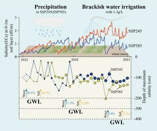
4.2. Precipitation Plays a Key Role in Soil Salt Transport

Rainfall is a key factor in climate change and plays an important role in driving soil water and salt transport [58,59]. It is therefore necessary to analyze the variation in salinity in response to climate change in order to adapt brackish water irrigation. Under the influence of high rainfall, the changes in soil salinity under the SSP585 climate scenario (Figure 16) were different from those of SSP245 (Figure 11 and Figure 14). After 30 years of irrigation with 1–3 g/L brackish water, the soil salinity of SSP585 was generally lower than that of SSP245, with the proportion of salt accumulation of the 0–100 cm soil layer of SSP585 decreased by 26.3%, and the high salt concentration zone (greater than 4 dS/m) was not obvious, indicating that rainfall under the SSP585 climate scenario was more conducive to soil salt leaching.
To further explore the key role of rainfall in this process, it could be seen from Figure 17 that both the SSP245 and SSP585 scenarios showed an increasing trend for the change in the maximum salinity, but the former had a higher salinity, and the overall burial depth was also shallower than the latter. The change in the maximum salinity depth was significantly correlated with rainfall (rSSP245 = 0.777, rSSP585 = 0.668, p < 0.05), which was consistent with the results of other scholars that the depth of salt leaching was positively correlated with precipitation [20,60], and the greater the precipitation was, the deeper the salt migration and leaching were. In addition, during dry years, such as 2027 under the SSP245 climate scenario and 2032 under the SSP585 climate scenario, the maximum salinity was near the 20 cm soil depth. During the wet years, such as 2033 of SSP245 and 2037 of SSP585, the maximum salinity moved down to the soil depth of 150 cm or even deeper. For a particularly wet year, such as SSP585 with rainfall of more than 900 mm, the salt could be leached to the soil layer below 2 m. During the normal years, the salt remained around 100–120 cm. The SSP585 climate scenario had better soil salt leaching effects than that of SSP245. During normal and wet years, large rainfall ensured that the salt leaching could reach the soil profile below 1 m. However, during the dry years, the cultivated soil might accumulate salts, and irrigation salt washing measures should be taken in time.
Groundwater levels affect soil water supply and salt content. Therefore, the identification of suitable groundwater levels for crop growth under different climate change scenarios is critical for a sustainable agriculture [27,29,61]. In the 0–100 cm crop root zone, soil salinity was lower than the crop salt tolerance threshold with less accumulated salts. It is therefore feasible to use 1–3 g/L brackish water for farmland irrigation under the SSP585 and SSP245 climate scenarios at 2–4 m groundwater levels. The analysis results further verified the conclusions of field and soil column experiments in this region [62,63,64,65]. However, as the added salts to the soil by brackish water irrigation can only migrate downward to the soil layer below 1 m, or even excrete into the groundwater, it is necessary to consider the impact of brackish water irrigation on groundwater quality. In fact, no significant difference in the salt concentration of the leachate under the two climate scenarios at the bottom of the 0–2 m soil profile was observed (Figure 18), which was mainly due to the characteristics of “water and salt go together”. For example, at the 3 m groundwater level (G3), the average amount of infiltration water and salt of SSP585 increased by about 25% compared to those of SSP245. However, the salt concentration of the leachate was related to the concentration of irrigation water and the groundwater level, especially when the groundwater level dropped from 3 m to 4 m. The salt concentration of the leachate rose sharply, which was twice as much as that of when the groundwater level dropped from 2 m to 3 m. This indicated that when the groundwater level dropped too deep, such as 4 m, brackish water irrigation was likely to exacerbate the risks of groundwater contamination. Due to the relatively higher soil salinity and greater salt accumulation in the root zone of the 0–100 cm soil profile at G2 compared to G3 or G4, and the evaluation of the effects of groundwater level on the salt concentration of the root zone, soil salt excretion, and groundwater mineralization, a groundwater level of 3 m is recommended as a safe groundwater level for brackish water irrigation to maintain soil salinity and sustain crop growth in this region. The results are also supported by previous studies [24,66] and further quantitatively analyzed and justified in this study.
The results of this paper could comprehensively reveal the long-term trend and influence mechanisms of soil water and salt movement, but more experiments are still needed in Yucheng GAS to improve the model accuracy and simulation performance in future studies. Moreover, the climate factors of temperature and carbon dioxide also have impacts on soil and crop growth [67,68,69], and the movement of water and salt in farmland soil is also closely related to soil structure, microbial activity, etc. [57,70]. These factors still remain to be studied in the future and will be of great significance to further enrich and improve the study of farmland ecosystems, mitigating the effects of climate change, utilizing brackish water, and managing salinization.

5. Conclusions

The research intended to provide a theoretical basis for the study of groundwater–farmland ecosystem processes and a scientific reference for the utilization of brackish water and the treatment of saline–alkali lands. Three main conclusions were derived from this study: (1) Precipitation was the key factor affecting soil water and salt transport, especially the water and salt content in the 0–20 cm soil layer. Affected by the rainfall in normal and wet years, the salt leaching reached soil layers below 1 m, and the salt accumulation mainly concentrated in the 1–2 m soil layer. In dry years, it is necessary to take irrigation and salt washing measures to prevent salt accumulation in the arable layer. Compared with the SSP245 climate scenario, SSP585 had higher rainfall and less soil water deficit, and the salt leaching level could reach soil layers below 2 m, leading to low soil salt concentration. (2) Groundwater level affected the water–salt interaction between soil, crops, and groundwater. The soil water and salt content in the 0–100 cm root zone increased with the increase in groundwater level. The 2 m groundwater level contributed about one-third to the water consumption of wheat and about one-fourth to the soil salt content, while the 4 m groundwater level had no significant recharge. Properly lowering the groundwater level can increase the salt-removal effect of the soil, but a too deep drop in the groundwater level can also lead to low soil water recharge and high salt concentration in the exudate. (3) The soil salinity profile generally showed an increasing trend after irrigation with 1–3 g/L brackish water in 30 years, which increased with the increase in the salt concentration of irrigation water, especially at the jointing–filling stage of winter wheat (from March to May each year). The salt accumulation was concentrated in the 1–2 m soil layer. Considering the risks of groundwater recharge, salt return, and groundwater quality, this study suggests that 3 m be used as a regulating groundwater level for irrigation with 1–3 g/L brackish water in the Yellow River Irrigation District, which can ensure that the soil salt content in the 0–100 cm root zone is below the salt tolerance threshold of winter wheat and summer maize, without affecting the normal crop growth. Furthermore, the impact factors of fertilization, soil types, and temperature on the movement of water and salt need to be analyzed in the future for the development of sustainable agroecosystem in the face of climate change.

Author Contributions

Conceptualization, K.H.; Methodology, K.H.; Formal analysis, K.H., Q.Z. and Z.A.; Investigation, N.X. and H.C.; Resources, Q.Z. and Z.A.; Writing – original draft, K.H.; Writing – review & editing, C.T., P.L., G.C. and F.L.; Visualization, N.X., Y.Q. and H.C.; Supervision, F.L.; Project administration, F.L. All authors have read and agreed to the published version of the manuscript.

Funding

This work was supported by the National Natural Science Foundation of China (grant numbers U2006212, U1906219, and 42007155) and the Fund of the Institute of Geographic Sciences and Natural Resources Research, Chinese Academy of Sciences (grant number E3V30030).

Data Availability Statement

The data presented in this study will be made available on request from the corresponding author.

Conflicts of Interest

The authors declare no conflict of interest.

References

  1. Hermans, K.; Müller, D.; O’Byrne, D.; Olsson, L.; Stringer, L.C. Land degradation and migration. Nat. Sustain. 2023. [Google Scholar] [CrossRef]
  2. Fischer, J.; Bennett, E.; Pe’er, G. Agriculture: Reform the global food system. Nature 2023, 622, 461. [Google Scholar] [CrossRef] [PubMed]
  3. Grote, U. Can we improve global food security? A socio-economic and political perspective. Food Secur. 2014, 6, 187–200. [Google Scholar] [CrossRef]
  4. Xia, L.; Yan, X. How to feed the world while reducing nitrogen pollution. Nature 2023, 613, 34–35. [Google Scholar] [CrossRef] [PubMed]
  5. Ren, C.; Zhang, X.; Reis, S.; Wang, S.; Jin, J.; Xu, J.; Gu, B. Climate change unequally affects nitrogen use and losses in global croplands. Nat. Food 2023, 4, 294–304. [Google Scholar] [CrossRef] [PubMed]
  6. Rumpel, C. Interactions between soils and climate change. In Encyclopedia of Soils in the Environment; Elsevier: Amsterdam, The Netherlands, 2022; pp. 82–90. [Google Scholar]
  7. Yan, W.; Zhong, Y.; Shangguan, Z.; Torn, M.S. Response of soil greenhouse gas fluxes to warming: A global meta-analysis of field studies. Geoderma 2022, 419, 115865. [Google Scholar] [CrossRef]
  8. Wang, M.; Guo, X.; Zhang, S.; Xiao, L.; Mishra, U.; Yang, Y.; Zhu, B.; Wang, G.; Mao, X.; Qian, T.; et al. Global soil profiles indicate depth-dependent soil carbon losses under a warmer climate. Nat. Commun. 2022, 13, 5514. [Google Scholar] [CrossRef]
  9. Feng, Z.; Wang, L.; Peng, Q.; Li, J.; Liang, T. Effect of environmental factors on soil properties under different land use types in a typical basin of the North China Plain. J. Clean. Prod. 2022, 344, 131084. [Google Scholar] [CrossRef]
  10. Fan, K.; Slater, L.; Zhang, Q.; Sheffield, J.; Gentine, P.; Sun, S.; Wu, W. Climate warming accelerates surface soil moisture drying in the Yellow River Basin, China. J. Hydrol. 2022, 615, 128735. [Google Scholar] [CrossRef]
  11. Eswar, D.; Karuppusamy, R.; Chellamuthu, S. Drivers of soil salinity and their correlation with climate change. Curr. Opin. Environ. Sustain. 2021, 50, 310–318. [Google Scholar] [CrossRef]
  12. Nazir, U.; Ehsanullah, S.A.A.; Farooq, A.; Nawaz, U.; Nawaz, M.; Samiullah, M. Climate Change and Agricultural Systems: Potential Impacts and Soil Management Strategies—A Review. J. Agric. Res. 2017, 2017, 501–515. [Google Scholar] [CrossRef]
  13. Olesen, J.R.E.; Bindi, M. Consequences of climate change for European agricultural productivity, land use and policy. Eur. J. Agron. 2002, 16, 239–262. [Google Scholar] [CrossRef]
  14. Gomez, A.M.R.; de Jong van Lier, Q.; Silvero, N.E.Q.; Inforsato, L.; de Melo, M.L.A.; Rodríguez-Albarracín, H.S.; Rosin, N.A.; Rosas, J.T.F.; Rizzo, R.; Demattê, J.A. Digital mapping of the soil available water capacity: Tool for the resilience of agricultural systems to climate change. Sci. Total Environ. 2023, 882, 163572. [Google Scholar] [CrossRef] [PubMed]
  15. Zhao, X.; Huang, M.; Yan, X.; Yang, Y. The impacts of climate change and cropping systems on soil water recovery in the 0-1500 cm soil profile after alfalfa. Agric. Water Manag. 2022, 272, 107878. [Google Scholar] [CrossRef]
  16. Wang, C.; Chen, J.; Gu, L.; Wu, G.; Tong, S.; Xiong, L.; Xu, C.-Y. A pathway analysis method for quantifying the contributions of precipitation and potential evapotranspiration anomalies to soil moisture drought. J. Hydrol. 2023, 621, 129570. [Google Scholar] [CrossRef]
  17. Zhang, B.; Zhang, Z.; Meng, X.; Liu, J.; Xia, T.; Guo, B.; Zhou, B.; Ji, J. Holocene synchronous evolution of precipitation and soil moisture as evidenced by paleosol deposits in the Ili Basin, Central Asia. Palaeogeogr. Palaeoclimatol. Palaeoecol. 2023, 615, 111466. [Google Scholar] [CrossRef]
  18. Yu, Z.; Yang, P. Climate change and its impact on soil moisture in Beijing-Tianjin-Hebei region in recent 50 years. Guizhou Agric. Sci. 2019, 47, 144–149. [Google Scholar]
  19. Khosravichenar, A.; Aalijahan, M.; Moaazeni, S.; Lupo, A.R.; Karimi, A.; Ulrich, M.; Parvian, N.; Sadeghi, A.; von Suchodoletz, H. Assessing a multi-method approach for dryland soil salinization with respect to climate change and global warming-The example of the Bajestan region (NE Iran). Ecol. Indic. 2023, 154, 110639. [Google Scholar] [CrossRef]
  20. He, K.; Yang, Y.; Yang, Y.; Chen, S.; Hu, Q.; Liu, X.; Gao, F. HYDRUS Simulation of Sustainable Brackish Water Irrigation in a Winter Wheat-Summer Maize Rotation System in the North China Plain. Water 2017, 9, 536. [Google Scholar] [CrossRef]
  21. Khasanov, S.; Li, F.; Kulmatov, R.; Zhang, Q.; Qiao, Y.; Odilov, S.; Yu, P.; Leng, P.; Hirwa, H.; Tian, C.; et al. Evaluation of the perennial spatio-temporal changes in the groundwater level and mineralization, and soil salinity in irrigated lands of arid zone: As an example of Syrdarya Province, Uzbekistan. Agric. Water Manag. 2022, 263, 107444. [Google Scholar] [CrossRef]
  22. Chen, J.; Tan, M.Z.; Zhao, B.Z.; Mi, S.-X.; Shi, X.-Z. Spatio-Temporal Variability of Soil Salinity in Alluvial Plain of the Lower Reaches of the Yellow River—A Case Study. Pedosphere 2011, 21, 793–801. [Google Scholar] [CrossRef]
  23. Wang, Z.; Li, Z.; Zhan, H.; Yang, S. Effect of long-term saline mulched drip irrigation on soil-groundwater environment in arid Northwest China. Sci. Total Environ. 2022, 820, 153222. [Google Scholar] [CrossRef] [PubMed]
  24. Wang, P.; Song, X.; Yuan, R.; Han, D.M.; Zhang, Y.H.; Zhang, B.; Li, B.G. Water flux estimation in SPAC system of farmland using Hydrus-1d model: A case of Dongcun Farm in Yuncheng City, Shanxi Province. Geogr. Res. 2011, 30, 622–634. [Google Scholar]
  25. Qiao, D.; Qi, X.; Pang, H.; Wu, H.; Fan, X.; Zhu, D.; Hu, C. Effects of brackish water irrigation on soil and crop under different groundwater depths. Trans. Chin. Soc. Agric. Eng. 2009, 25, 55–61. [Google Scholar]
  26. Qiao, Y.; Yu, Z. Simulation stdy on the effects of irrigation on soil salt and saline water exploration. Acta Ecol. Sin. 2003, 23, 2050–2056. [Google Scholar]
  27. Li, X.; Xia, J.; Zhao, X.; Chen, Y. Effects of planting Tamarix chinensis on shallow soil water and salt content under different groundwater depths in the Yellow River Delta. Geoderma 2019, 335, 104–111. [Google Scholar] [CrossRef]
  28. Aboelsoud, H.M.; Habib, A.; Engel, B.; Hashem, A.A.; El-Hassan, W.A.; Govind, A.; Elnashar, A.; Eid, M.; Kheir, A.M. The combined impact of shallow groundwater and soil salinity on evapotranspiration using remote sensing in an agricultural alluvial setting. J. Hydrol.-Reg. Stud. 2023, 47, 101372. [Google Scholar] [CrossRef]
  29. Han, M.; Zhao, C.; Simunek, J.; Feng, G. Evaluating the impact of groundwater on cotton growth and root zone water balance using Hydrus-1D coupled with a crop growth model. Agric. Water Manag. 2015, 160, 64–75. [Google Scholar] [CrossRef]
  30. Burst, M.; Chauchard, S.; Dambrine, E.; Dupouey, J.-L.; Amiaud, B. Distribution of soil properties along forest-grassland interfaces: Influence of permanent environmental factors or land-use after-effects? Agric. Ecosyst. Environ. 2020, 289, 106739. [Google Scholar] [CrossRef]
  31. Mao, X.; Zheng, J.; Yu, W.; Guo, X.; Xu, K.; Zhao, R.; Xiao, L.; Wang, M.; Jiang, Y.; Zhang, S.; et al. Climate-induced shifts in composition and protection regulate temperature sensitivity of carbon decomposition through soil profile. Soil Biol. Biochem. 2022, 172, 108743. [Google Scholar] [CrossRef]
  32. Li, Z.; Sun, A.; Liu, X.; Chen, Q.-L.; Bi, L.; Ren, P.-X.; Shen, J.-P.; Jin, S.; He, J.-Z.; Hu, H.-W.; et al. Climate warming increases the proportions of specific antibiotic resistance genes in natural soil ecosystems. J. Hazard. Mater. 2022, 430, 128442. [Google Scholar] [CrossRef] [PubMed]
  33. Anindita, S.; Sleutel, S.; Finke, P. Land use impacts on weathering, soil properties, and carbon storage in wet Andosols, Indonesia. Geoderma 2022, 423, 115963. [Google Scholar] [CrossRef]
  34. Yan, X.; Xia, L.; Ti, C. Win-win Nitrogen Management Practices for Improving Crop Yield and Environmental Sustainability. Bull. Chin. Acad. Sci. 2018, 33, 177–183. [Google Scholar]
  35. Xiao, C.; Ji, Q.; Zhang, F.; Li, Y.; Fan, J.; Hou, X.; Yan, F.; Liu, X.; Gong, K. Effects of various soil water potential thresholds for drip irrigation on soil salinity, seed cotton yield and water productivity of cotton in northwest China. Agric. Water Manag. 2023, 279, 108172. [Google Scholar] [CrossRef]
  36. Che, Z.; Wang, J.; Li, J. Effects of water quality, irrigation amount and nitrogen applied on soil salinity and cotton production under mulched drip irrigation in arid Northwest China. Agric. Water Manag. 2021, 247, 106738. [Google Scholar] [CrossRef]
  37. Yang, J.; Shao, Y.; Gao, W.; Ren, S. Effects of Saline Water Irrigation on Soil Salinity and Crop Yield. Bull. Soil Water Conserv. 2013, 33, 17–20. [Google Scholar]
  38. Dong, X.; Wang, J.; Zhang, X.; Dang, H.; Singh, B.P.; Liu, X.; Sun, H. Long-term saline water irrigation decreased soil organic carbon and inorganic carbon contents. Agric. Water Manag. 2022, 270, 107760. [Google Scholar] [CrossRef]
  39. Liu, C.; Li, K.; Geng, Y.; Li, Q. Microstructure characteristics of soils with different land use types in the Yellow River Delta. Trans. Chin. Soc. Agric. Eng. 2020, 36, 81–87. [Google Scholar]
  40. Qian, Y.; Zhang, Z.; Fei, Y.; Chen, J.; Zhang, F.E.; Wang, Z. Sustainable exploitable potential of shallow groundwater in the North China Plain. Chin. J. Eco-Agric. 2014, 22, 890–897. [Google Scholar]
  41. Chen, S.; Song, C.; Mao, X.; Shang, S. Modeling response of spring wheat yield to soil water and salt contents and its application in scheduling brackish water irrigation. Comput. Electron. Agric. 2022, 200, 107216. [Google Scholar] [CrossRef]
  42. Zhang, Y.; Li, X.; Simunek, J.; Shi, H.; Chen, N.; Hu, Q.; Tian, T. Evaluating soil salt dynamics in a field drip-irrigated with brackish water and leached with freshwater during different crop growth stages. Agric. Water Manag. 2021, 244, 106601. [Google Scholar] [CrossRef]
  43. Ouyang, Z.; Qiao, Y.; Zhan, C.; Sun, Z.; Yu, Y.; Cai, X.; Li, F. Groundwater-Agroecosystem Experimental Simulator (Yucheng GAS). Bull. Chin. Acad. Sci. 2021, 36, 852–861. [Google Scholar]
  44. Feng, G.; Zhu, C.; Wu, Q.; Wang, C.; Zhang, Z.; Mwiya, R.M.; Zhang, L. Evaluating the impacts of saline water irrigation on soil water-salt and summer maize yield in subsurface drainage condition using coupled HYDRUS and EPIC model. Agric. Water Manag. 2021, 258, 107175. [Google Scholar] [CrossRef]
  45. Wang, J.J.; Long, H.Y.; Huang, Y.F.; Wang, X.; Cai, B.; Liu, W. Effects of different irrigation management parameters on cumulative water supply under negative pressure irrigation. Agric. Water Manag. 2019, 224, 105743. [Google Scholar] [CrossRef]
  46. Zeng, W.Z.; Xu, C.; Wu, J.; Huang, J. Soil salt leaching under different irrigation regimes: HYDRUS-1D modelling and analysis. J. Arid Land 2014, 6, 44–58. [Google Scholar] [CrossRef]
  47. Richards, L.A. Capillary conduction of liquids through porous mediums. Phys.-A J. Gen. Appl. Phys. 1931, 1, 318–333. [Google Scholar] [CrossRef]
  48. Šimůnek, J.; Sejna, M.; Saito, H.; Sakai, M.; van Genuchten, M.T. The Hydrus-1D Software Package for Simulating the Movement of Water, Heat, and Multiple Solutes in Variably Saturated Media, Version 4.17; HYDRUS Software Series 3; Department of Environmental Sciences, University of California Riverside: Riverside, CA, USA, 2013. [Google Scholar]
  49. Belmans, C.; Wesseling, J.G.; Feddes, R.A. Simulation model of the water balance of a cropped soil: SWATRE. J. Hydrol. 1983, 63, 271–286. [Google Scholar] [CrossRef]
  50. Zhou, T.; Zou, L.; Chen, X. Commentary on the Coupled Model Intercomparison Project Phase 6 (CMIP6). Progress. Inquisitiones Mutat. Clim. 2019, 15, 445–456. [Google Scholar]
  51. O’Neill, B.C.; Tebaldi, C.; van Vuuren, D.P.; Eyring, V.; Friedlingstein, P.; Hurtt, G.; Knutti, R.; Kriegler, E.; Lamarque, J.-F.; Lowe, J.; et al. The Scenario Model Intercomparison Project (ScenarioMIP) for CMIP6. Geosci. Model Dev. 2016, 9, 3461–3482. [Google Scholar] [CrossRef]
  52. Zhang, L.; Chen, X.; Xin, X. Short commentary on CMIP6 Scenario Model Intercomparison Project (ScenarioMIP). Progress. Inquisitiones Mutat. Clim. 2019, 15, 519–525. [Google Scholar]
  53. Ayers, R.S.; Westcot, D.W. Water Quality for Agriculture; Food and Agriculture Organization of the United Nations: Rome, Italy, 1976. [Google Scholar]
  54. Li, N.; Ren, L.; Tang, Z. Modeling and analyzing water flow in a thick unsaturated zone during precipitation and infiltration. Trans. Chin. Soc. Agric. Eng. 2013, 29, 94–100. [Google Scholar]
  55. Zhang, Q.; Zhao, Z.; Jia, L.; Wang, W.; Jia, W. Analysis of land subsidence status and influencing factors in Yellow River Delta. Sci. Surv. Mapp. 2022, 47, 165–173. [Google Scholar]
  56. Mao, P.; Guo, L.; Cao, B.; Pang, Y.; Liu, W.; Tan, C.; Jia, B.; Cao, Z. Effects of Groundwater Mineralization and Groundwater Depth on Eco-Physiological Characteristics of Robinia pseudoacacia L. in the Yellow River Delta, China. Forests 2022, 13, 915. [Google Scholar] [CrossRef]
  57. Chen, S.; Mao, X.; Shang, S. Response and contribution of shallow groundwater to soil water/salt budget and crop growth in layered soils. Agric. Water Manag. 2022, 266, 107574. [Google Scholar] [CrossRef]
  58. Walter, J.; Lueck, E.; Bauriegel, A.; Facklam, M.; Zeitz, J. Seasonal dynamics of soil salinity in peatlands: A geophysical approach. Geoderma 2018, 310, 1–11. [Google Scholar] [CrossRef]
  59. Liu, B.; Wang, S.; Kong, X.; Liu, X. Soil matric potential and salt transport in response to different irrigated lands and soil heterogeneity in the North China Plain. J. Soils Sediments 2019, 19, 3982–3993. [Google Scholar] [CrossRef]
  60. Liu, B.; Wang, S.; Liu, X.; Sun, H. Evaluating soil water and salt transport in response to varied rainfall events and hydrological years under brackish water irrigation in the North China Plain. Geoderma 2022, 422, 115954. [Google Scholar] [CrossRef]
  61. Xu, X.; Huang, G.; Sun, C.; Pereira, L.S.; Ramos, T.B.; Huang, Q.; Hao, Y. Assessing the effects of water table depth on water use, soil salinity and wheat yield: Searching for a target depth for irrigated areas in the upper Yellow River basin. Agric. Water Manag. 2013, 125, 46–60. [Google Scholar] [CrossRef]
  62. Yin, C.-Y.; Zhao, J.; Chen, X.-B.; Li, L.-J.; Liu, H.; Hu, Q.-L. Desalination characteristics and efficiency of high saline soil leached by brackish water and Yellow River water. Agric. Water Manag. 2022, 263, 107461. [Google Scholar] [CrossRef]
  63. Zhu, J.; Sun, J.; Zhang, Z.; Yang, R.; Pan, Y.; Yang, M. Effects of Alternate Irrigation with Brackish and Fresh Water on Water and Salt Movement in Coastal Saline Soil. Res. Soil Water Conserv. 2019, 26, 113–117. [Google Scholar]
  64. Wang, T.; Xu, Z.; Pang, G. Effects of Irrigating with Brackish Water on Soil Moisture, Soil Salinity, and the Agronomic Response of Winter Wheat in the Yellow River Delta. Sustainability 2019, 11, 5801. [Google Scholar] [CrossRef]
  65. Wang, H.; Xu, Z.; Pang, G.; Zhang, L.; Wang, X. Effects of Brackish Water Irrigation on Water-salt Distribution and Winter Wheat Growth. J. Soil Water Conserv. 2017, 31, 291–297. [Google Scholar]
  66. Xie, T.; Liu, X.; Sun, T. The effects of groundwater table and flood irrigation strategies on soil water and salt dynamics and reed water use in the Yellow River Delta, China. Ecol. Model. 2011, 222, 241–252. [Google Scholar] [CrossRef]
  67. Hua, D.; Hu, S.; Mo, X. Impacts of water conservancy projects on agricultural water use efficiency and crop productivity in the Nianchu River Basin of China. Trans. Chin. Soc. Agric. Eng. 2022, 38, 98–107. [Google Scholar]
  68. Zhao, Y.; Xiao, D.; Bai, H.; Zhao, Y.; Xiao, D.; Huizi, B.; Tao, F. Research progress on the response and adaptation of crop phenology to climate change in China. Prog. Geogr. 2019, 38, 224–235. [Google Scholar]
  69. Xiao, D.; Tao, F. Impact of climate change in 19812009 on winter wheat phenology in the North China Plain. Chin. J. Eco-Agric. 2012, 20, 1539–1545. [Google Scholar] [CrossRef]
  70. Philippot, L.; Chenu, C.; Kappler, A.; Rillig, M.C.; Fierer, N. The interplay between microbial communities and soil properties. Nat. Rev. Microbiol. 2023. [Google Scholar] [CrossRef]
Figure 1. The location of Yucheng station at the Yellow River Irrigation District in China.
Agronomy 14 00092 g001
Figure 2. Comparison between simulated and measured values of soil water content in different soil layers ((A,B) are the calibrated and validated water contents, respectively).
Agronomy 14 00092 g002
Figure 3. The simulated and observed 1:1 goodness-of-fit line for salinity in 0–100 cm soil profile ((A,B) are the calibrated and validated salinity, respectively).
Agronomy 14 00092 g003
Figure 4. SSP245 precipitation and soil water content at different buried depths in 0–60 cm soil profile.
Agronomy 14 00092 g004
Figure 5. SSP585 precipitation and soil water content at different buried depths in 0–60 cm soil profile.
Agronomy 14 00092 g005
Figure 6. The difference in soil water deficit between SSP245 and SSP585 (positive red bar represents a much higher water deficit of SSP245; negative blue bar represents a much higher water deficit of SSP585).
Agronomy 14 00092 g006
Figure 7. Soil water and salt content in 0–100 cm soil profile under three groundwater levels of SSP245 scenario ((A): soil water content; (B): soil salt content).
Agronomy 14 00092 g007
Figure 8. Changes in groundwater recharge flux under different groundwater levels (positive indicates upward water flux, representing recharge processes; negative indicates downward water flux, representing water leakage processes).
Agronomy 14 00092 g008
Figure 9. Comparison of groundwater recharge under the climatic scenarios of SSP245 and SSP585 with 2 m groundwater level.
Agronomy 14 00092 g009
Figure 10. Changes in soil salinity in the 0–300 cm profile under different salt concentrations of brackish water irrigation. (S0-G3-SSP245, S1-G3-SSP245, S2-G3-SSP245, and S3-G3-SSP245 represent four brackish water irrigation schemes of 0 g/L, 1 g/L, 2 g/L, and 3 g/L salt concentration at 3 m groundwater level under the SSP245 scenario.)
Agronomy 14 00092 g010
Figure 11. Migration and change of salt content in each layer of the soil profile from 0 to 300 cm (G3-SSP245 scenario).
Agronomy 14 00092 g011
Figure 12. Variability coefficient of soil salinity at different soil layers irrigated with 1–3 g/L brackish water.
Agronomy 14 00092 g012
Figure 13. Changes in salt content in different soil layers every 15 years.
Agronomy 14 00092 g013
Figure 14. The changes in salinity in the soil profile at different groundwater levels. ((Left): S1-G2-SSP245, S2-G2-SSP245, and S3-G2-SSP245 represented brackish water irrigation schemes of 1 g/L, 2 g/L, and 3 g/L salt concentration at 2 m groundwater level under SSP245; (Right): S1-G4-SSP245, S2-G4-SSP245, and S3-G4-SSP245 represented brackish water irrigation schemes of 1 g/L, 2 g/L, and 3 g/L salt concentration at 4 m groundwater level under SSP245).
Agronomy 14 00092 g014
Figure 15. Salt accumulation in soil layers under different groundwater depths (GWD). (S1, S2 and S3 represented brackish water irrigation schemes of 1 g/L, 2 g/L, and 3 g/L salt concentration).
Agronomy 14 00092 g015
Figure 16. Changes in soil salinity under the SSP585 scenario.
Agronomy 14 00092 g016
Figure 17. Relationship between the depth of maximum salinity in soil profiles and annual rainfall under 3 g/L brackish water irrigation and 3 m groundwater level (S3–G3 scenario) (the circle size represents the values of salinity).
Agronomy 14 00092 g017
Figure 18. Salt concentration of seepage water at the bottom of the 0–2 m soil layer under 1–3 g/L brackish water irrigation.
Agronomy 14 00092 g018
Table 1. Simulation scheme designs and different scenario combinations in the research. (SSP245/SSP585 represent climate scenario; G2, G3, and G4 represent groundwater levels of 2 m, 3 m, and 4 m; S0, S1, S2, and S3 represent salt concentration levels of brackish water irrigation, including 0 g/L, 1 g/L, 2 g/L, and 3 g/L).
SSP245/SSP585G2G3G4
S0S0-G2S0-G3S0-G4
S1S1-G2S1-G3S1-G4
S2S2-G2S2-G3S2-G4
S3S3-G2S3-G3S3-G4
Table 2. Comparison of groundwater recharge under different climate scenarios (mm).
Climate
Scenario
2 m Groundwater Level (G2) 3 m Groundwater Level (G3) 4 m Groundwater Level (G4)
Wheat SeasonCorn SeasonAnnual AverageWheat SeasonCorn SeasonAnnual AverageWheat SeasonCorn SeasonAnnual Average
SSP245116−655164−559101727
SSP585100−95552−421029−32−3
Disclaimer/Publisher’s Note: The statements, opinions and data contained in all publications are solely those of the individual author(s) and contributor(s) and not of MDPI and/or the editor(s). MDPI and/or the editor(s) disclaim responsibility for any injury to people or property resulting from any ideas, methods, instructions or products referred to in the content.

