1. Introduction
The necessity to adapt to climate change, in addition to reducing greenhouse gas emissions, has been widely acknowledged by scientists and policymakers [
1,
2,
3]. Such claims are specifically addressed to agriculture and forestry, the most important land-use sectors, which are, on the one hand, vulnerable to climate change and, on the other, have the potential to implement mitigation and adaptation strategies [
4]. However, while there are scientific results for the effects of climate change on agriculture (both positive and negative) and specifically on mountain agriculture [
5,
6], there is only limited evidence that local stakeholders develop collective strategies to adapt to the predicted changes. For instance, a recent study on the status of climate change adaptation (CCA) strategies by agricultural stakeholders in the Austrian federal province of Tyrol concludes that “the great amount of scientific articles and policy strategies for CCA have not yet trickled down to the sector’s practices […]. Farmers and their supportive networks are much concerned with more pressing challenges than climate change. As they have to tackle market or policy changes affecting them today and tomorrow, they cannot allocate much time for considering the long-term impacts of climate change” [
7] (p. 1855). Immediate economic challenges indeed often prevent a long-term perspective on ecological trends, like those induced by climate change [
8,
9,
10]. But present activities, as a response to market or policy requirements, in turn impact on the future options for CCA.
To close this gap, we want to examine how including non-academic stakeholders into the research process can contribute to the development of local CCA strategies. We present the example of a transdisciplinary approach that integrates stakeholders into the research process and produces tangible pictures of a desired future, which may serve as a guideline for further local/regional planning. To generate pictures of possible futures, we used scenarios constructed on the basis of current conditions, which represent future trends. Scenarios are specifically useful for situations in which the factors shaping the future are highly uncertain and largely uncontrollable. They portray potential possible trajectories, rather than predicting the most likely outcome [
11]. Scenarios have been used for combined projections of both climate and socio-economic futures, representing uncertainties in complex dynamic systems [
12]. Combining socio-economic and climate scenarios may reconcile the above-mentioned discrepancy between long-term CCA and the immediate price volatility. A socio-ecological systems’ perspective helps in structuring the assessment of the drivers of change, as embedded in hierarchies, with slow and fast changes on larger and smaller scales [
13]. The management of socio-ecological systems requires long-term strategies [
14], which are limited by a number of uncertainties regarding the long-term effects of climate change, as well as by the impact of social and economic changes in the shorter term. Combined scenarios may provide plausible storylines about the future of a socio-ecological system, unfolding from existing patterns, but including alternative human choices [
15]. Moreover, they may be helpful in assessing climate-change impacts and vulnerabilities, not only across different time scales, but also across different sectors and their specific uncertainties [
12].
Approaches to combined scenarios are often distinguished according to two dimensions—their approach (top-down or bottom-up) and their spatial scale (from global to local) [
12]. Top-down approaches usually start from a given context of socio-economic and technological development. They perceive climate change as a response to these trends. Such responses are increasingly downscaled to a regional/local level so as to provide input for strategic decisions. One of the most prominent examples is the IPCC approach, combining climate scenarios with shared socio-economic pathways (SSP). The socio-economic futures are framed in this process as consequences of the capacity to mitigate and adapt to the impacts of climate change. The simulations of the future climate, like the IPCC Special Report on Emission Scenarios (SRES) climate scenarios [
16] and representative concentration pathways (RCPs) [
17], are based on assumed global socio-economic conditions. Downscaling uses mostly top-down approaches involving the refinement of models to local climatic phenomena. Real land use and the resulting greenhouse gas emissions and local or regional socio-economic patterns, however, may deviate substantially from these assumptions.
Bottom-up approaches start with an assessment of the factors of resilience or vulnerability, and seek to assess the capability to cope with the effects of climate change. The main research question of these studies is to estimate the combined effects of climate and socio-economic change on the vulnerability and resilience of socio-economic systems. Such resilience-based approaches have been criticized as being too complex, research intensive, time consuming, costly, and difficult to compare [
12]. If the downscaling of global scenarios uses a bottom-up approach, relevant information is often defined in cooperation with stakeholders, resulting in region-specific scenarios. Stakeholder interaction involves the assessment of what is relevant for decision making. Regionally downscaled participatory scenario development integrates stakeholder views with research to understand long-term changes, and investigates the potential futures of socio-ecological systems [
1,
18,
19,
20]. An example of such an approach is the creation of a knowledge-to-action-network in Idaho (USA) [
21], where stakeholders and researches decided to plan for a future with less water as an effect of climate change.
Although, in our study, we used elements of the top-down as well as bottom-up scenario development, our approach differs from both of these approaches. First of all, we did not primarily aim to investigate the effects of climate change on a given local situation (like in downscaled IPCC models), but wanted to demonstrate the local sphere of influence on the long-term impact of land-use changes as a combined result of climate change and various local socio-economic development options. Our starting point was to measure the differences in runoff (as a measure of water availability) caused by changing land use and the resulting forest cover. We assumed the future land use to be a combined response to socio-economic change and climate change. The aim was not to design CCA strategies as such (like in many bottom-up approaches), but to determine the influence of local actors on the effects of climate change in a given region by choosing different options for future land use. The process of scenario development did not result in a CCA strategy, but served as the basis for the scientific analysis of the impact of land-use changes on future water availability.
Agriculture and forestry are the two major land users in our study site and, as most of forests are owned by farmers, agricultural stakeholders are key actors. Land-use changes, especially an increase in the forested area, for instance, by the conversion of mountain pastures into forests, have long-term effects that are difficult to reverse. Especially in mountain areas, agriculture is inextricably intertwined with tourism and other economic sectors. On the one hand, traditional farming practices keep the landscape open and provide a basis for other economic activities. On the other hand, many farms are not viable by farming alone, and farmers have to find additional income options. Because of this multifunctionality of agriculture, adaptation strategies often involve not only decisions by individual farmers, but also demand a collective multi-stakeholder approach. In addition to the individual land owners, a variety of stakeholders, such as tourism associations and ski lift operators, municipalities, energy providers, farming associations, foresters, and forest authorities, are involved in decisions regarding land use and land-use change. Furthermore, it is part of the agricultural policy framework for less favored and mountainous areas to direct the spatial development towards a desired future [
22]. An adaptation to climate change thus requires, on the one hand, long-term perspectives and, on the other, coherent collective territorial strategies. However, collective decisions about desirable future land use need to be based on detailed knowledge about the consequences of current trends, and have room to maneuver, which these actions entail.
Scientific modelling of the outcomes of different land use may provide such knowledge, which is needed by stakeholders in order to make decisions about future development. Our hydrological model calculated the combined effects of land-use and climate change on streamflow at the river gauge. The streamflow includes all of the hydrological processes on the catchment scale and is therefore viewed as a measure of water availability. The results of our modelling do not include extreme events like flood peaks. Water is considered a public good, which has a multitude of users and an increasing potential for resource use conflicts. Climate change will add to the current economic and social challenges for integrated water resources management [
23,
24].
This paper focuses on the learning effects between scientists and the regional stakeholders who transform the results into development strategies. In this sense, our study included inter- and trans-disciplinary aspects. The interdisciplinary approach included the collaboration of researchers from different scientific backgrounds. Social scientists developed the basic socio-economic scenarios, while researchers from natural sciences downscaled the global climate scenarios and modelled the hydrological runoff. Both disciplines cooperated so as to integrate the scenarios into a hydrological model and to interpret the results. For the concept of transdisciplinarity, we applied the definition provided by Lang et al. [
25] (p. 26), “Transdisciplinarity is a reflexive, integrative, method-driven scientific principle aiming at the solution or transition of societal problems and concurrently of related scientific problems by differentiating and integrating knowledge from various scientific and societal bodies of knowledge”. In our study, the transdisciplinary process connected the researchers with non-academic stakeholders in the region, who provided feedback on the scenarios and helped to translate the narrative descriptions into quantitative figures for hydrological modelling. This definition of transdisciplinary, together with the goal of the study—to provide local stakeholders with a better basis for decision making—can be understood as a post-normal science (PNS) [
26] approach. Climate change has been identified as a “wicked problem”, because of the complexity of coupled human and natural systems [
27]. For the most part, approaches of “normal science” cannot answer questions posed by policy stakeholders for managing complex systems generating wicked problems. According to König et al. [
28], the methodology of PNS aims for a more robust “science for policy” interphase by involving an extended peer community, both
internally and
externally. While the internal inclusion of multiple disciplines for the scientific management of quality and uncertainty was achieved within our project team, we also included an external peer community at certain points of our research. Local representatives of relevant land-user groups (like farmers, tourism operators, and foresters) participated in the validation of the scenarios, and forestry experts from the provincial department helped to transform the narrative descriptions into numerical rules for model calculation. After modelling, the same stakeholders were invited to discuss the applicability of the results to regional strategies. This participatory approach was intended to assist in the future implementation of results into CCA strategies.
2. The Study Site
The empirical basis for this paper is provided by the research conducted within the project STorylines of coupled socio-Economic and cLimatic drivers for Land use and their hydrological impacts in Alpine catchments (STELLA), which was funded by the Austrian Climate Research Program (ACRP; sixth call) of the Austrian Climate and Energy Fund. The project, realized between August 2014 and August 2017, focused on the impact of long-term land-use changes, understood as the combined effect of socio-economic drivers and climate change, on the water-balance components in the catchment.
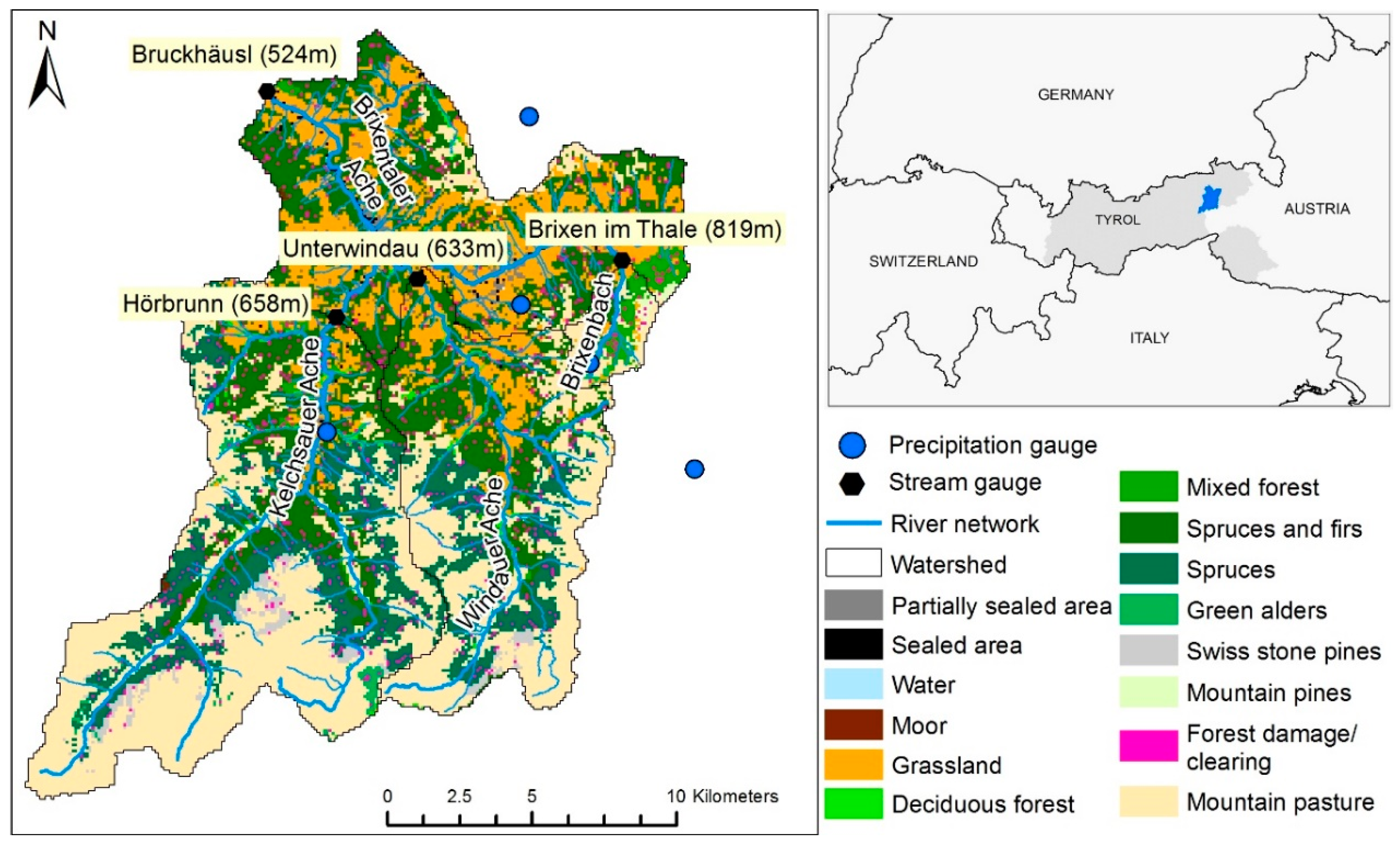
The study site is The Brixental, representing the catchment area of the Brixentaler Ache (
Figure 1). The Brixental is located in the eastern Alps in the federal province of Tyrol in Austria. The catchment of The Brixentaler Ache and its tributaries cover an area of 322 km
2. The altitude ranges from 524 m above sea level at the Bruckhäusl gauge, to 2494 m at the highest point. The study site has an annual precipitation of roughly 1400 mm and is—as of to 2018—not experiencing a water shortage.
Land use in The Brixental is dominated by agriculture and forestry. Tourism is an important economic sector and most activities (skiing in winter and hiking in summer) are practiced on agricultural land. The agriculture is dominated by dairy farming on permanent grasslands. Compared with other parts of Tyrol, the farms are bigger and the percentage of farms operating with dairy farming as their main occupation is higher. Still, agriculture in the district is small-scale in structure, with an average 16 cows per dairy farm [
31]. While about two thirds of all farmers keep dairy cows, another third have switched to suckler cows, a more labor-extensive form of farming. On average, they have six mother cows per farm, which is typical for small-scale part-time farming. The percentage of organic farms is relatively high (36% of all farms) [
32], and as virtually all mountain pastures are managed according to organic principles, an impressive 70.7% of the land area is organic (compared with 37.13% at a provincial level). This indicates the importance of mountain pastures for the district. The district of Kitzbühel (to which the study area belongs) has the highest share of mountain pastures and of dairy cows on mountain pastures during the summer period, within the province as well as on a national scale. Of the 12,000 dairy cows kept in the district, 11,000 graze on mountain pastures during the summer season [
33]. Currently, we have observed opposing trends in agricultural land use on a provincial level. Flat areas, where big machinery can be used, are managed more and more intensively, while the mowing of slopes is gradually reduced and being replaced by grazing or afforestation. Similarly, on mountain pastures, milking cows are increasingly replaced by young stock or suckler cows, which require less intense management [
22]. More than half of all farmers run their farms part-time and find additional income, or most often even their main income, from off-farm employment [
31]. While these part-time farmers tend towards managing their farms labor-extensively, the remaining full-time farmers intensify their land management in order to stay competitive and economically viable.
Forest cover in the entire province has steadily increased over the last 30 years by around 5% (about 900 ha per year), and is currently at 41.2% [
34]. In The Brixental catchment, forest covers 43% of the total area. Conifers dominate the forest composition, with spruce being the most prevalent tree species. Larch trees, firs, mountain pines, and grey and green alders occur in smaller proportion [
35]. The distribution of forest ownership in the area is similar to that in the province; about one third of the forest area is privately owned, one third is owned by farming associations, and one third is in public ownership (local municipalities or the federal state) [
36]. Private forests are usually quite small and, until recently, predominantly in the hands of farmers. The statistics provided by the district forest department show that about 30% of the forest owners own less than 20 ha, and fewer than half the forest owners have up to 40 ha. Forestry, which contributes substantially to the income of agricultural forestry owners [
34], is of strategic importance for the resilience of the farming system. However, the ownership structure is changing as a consequence of the structural change in agriculture. If farms close down, agricultural areas are rented out or sold, but forests are usually kept. With a change in the ownership structure, the motivation for forestry changes as well. According to our interviews with key experts, farmers are more interested in productive forestry than non-farming private forest owners. Societal interest in forests for natural hazard protection is increasing, and there is growing interest in forests as a resource for renewable energy production and for construction material. Although timber harvesting is rising, at the same time, the forest stock increases. It indicates that the potential of forest resources is not fully utilized yet. In addition to the present 1.5 million cubic meters presently harvested per annum, about 1.7–1.8 million cubic meters of timber could be extracted sustainably from the Tyrolean forests [
34].
The natural timberline has been suppressed over centuries by the utilization of mountain pastures up to the highest elevations for summer grazing of cows. The potential timberline is at the height of the mountain summits and, as there are only few rock formations in the region, the mountains here are often referred to as “grass mountains” (
Grasberge in German). If pastures are abandoned, forest succession takes place on the entire mountain area. Already today, forest re-growth can be observed in many areas [
37] due to pressures on the current farming system and the resulting reduced use of mountain pastures. Thus, the highest increase of forest area is observed in the subalpine and alpine regions. Conifers dominate the forest composition, with spruce being the prevalent tree species. Larch trees, firs, mountain pines, and grey and green alders occur in smaller proportions. Land-use changes concerning the forested area are expected to have the most measurable and long-lasting effect on the water balance [
38].
3. Methodological Approach to Creating Scenarios and Storylines
Hydrological catchments often serve as a convenient scale for environmental system analysis [
19], as they have natural boundaries and represent units for natural resource management [
39,
40]. They provide water supply for food and energy production and domestic use, as well as touristic infrastructure (e.g., artificial snow making). For the catchment of The Brixentaler Ache, the STELLA project measured the combined impacts of land-use and climate change on the water balance as well as the streamflow response of catchments to precipitation events.
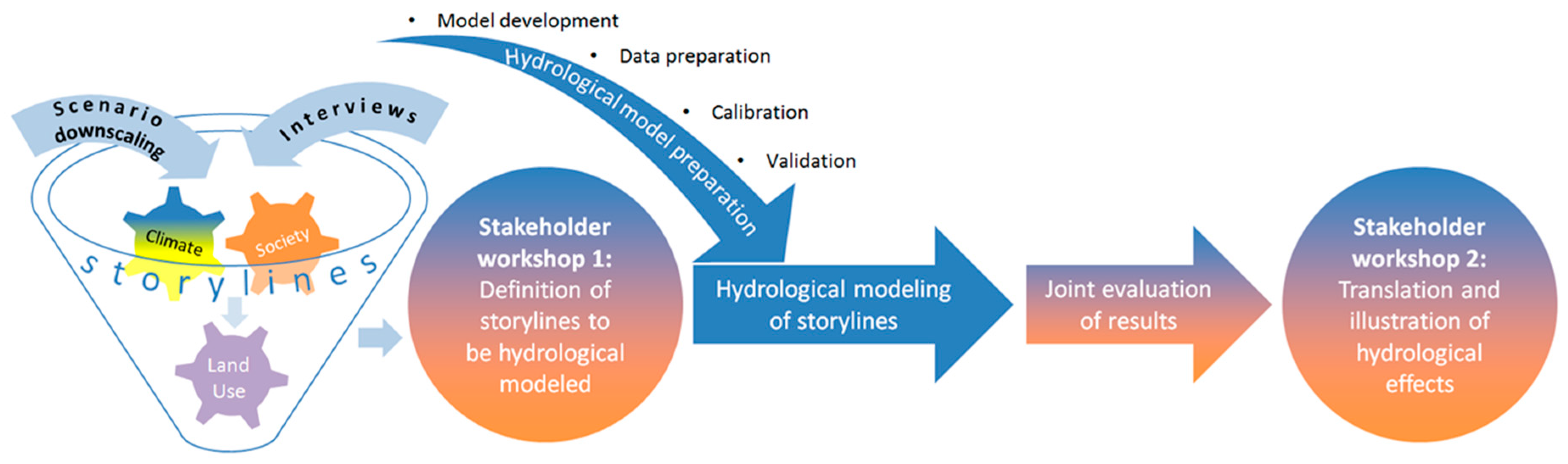
Figure 2 describes the empirical steps of the STELLA project. We started with downscaling climate scenarios and the elicitation of socio-economic trends, which we transformed into socio-economic scenarios. By combining local climate and socio-economic scenarios, we generated storylines describing potential land use changes. These storylines were validated in a participatory stakeholder process (stakeholder workshop 1) for their plausibility and consistency. In the next step, together with forest experts, we selected three distinct pathways of forest management out of 12 storylines. The forest experts helped to translate the narrative descriptions of these pathways into quantitative figures as input for transient land use maps as a basis for hydrological modelling. After modelling, the interdisciplinary research team evaluated the results and presented them to the group of local stakeholders again for discussion and further practical application (stakeholder workshop 2).
The finally selected storylines for hydrological modelling were based on the projected land-use changes, which were induced by local scenarios of climate change in combination with scenarios of socio-economic development.
Table 1 summarizes our approach to create the storylines.
To depict climate change, two scenarios were developed by downscaling the global climate projections. They were bias-corrected and were adapted to the study region with a resolution of 1 km. The first one, representing moderate climate change, was based on the SRES A1B emission scenario [
16], which corresponds to a moderate increase of greenhouse gases within the 21st century. Details about the selection of the A1B model run, the regional climate model provided by the Centre National de Recherches Météorologique (CNRM) called CNRM-RM4.5 [
41], and the post-processing applied are described in Meißl et al. [
42]. In this scenario (CNRM_ARPEGE-RM5.1_ALADIN_25km_A1B), an increase around three degrees in temperature is expected, by the end of the century. Precipitation shows no clear trend in the first half of the 21st century, and annual rainfall remains roughly the same, with a small decrease by the end of the 21st century. Heavy rainfall events are generally expected to increase, but the effects of climate change are expected to remain manageable. It even expects some effects that will play out beneficially for agriculture—the increase of temperature results in the growing period being prolonged by up to three weeks, with water availability still being sufficient. However, single dry and hot summers may cause problems for the quantity of winter feed and for grazing on mountain pastures. In the forests, this may result in increased bark beetle calamities. While tourism in summer as well as in spring and autumn may benefit from the warmer and partly steadier weather conditions, winter tourism will suffer from a reduction in natural snow cover, and will need increased efforts in technical snow production.
The other one was derived from the RCP 8.5 scenario [
17], which corresponds to a strong increase in greenhouse gases. Here, we used the Climate Model version 3 (CM3) developed by the Geophysical Fluid Dynamics Laboratory (GFDL) as a coupled general circulation model [
43] and the regional climate model developed by the Weather Research and Forecast (WRF) project [
44] in an optimized version for the Alpine region [
45]. This scenario (BOKU_GFDL-CM3_WRF_10km_RCP8.5) represents a worst-case situation. It expects a rise in temperature of up to eight degrees by the end of the century, with stronger warming during the summer period. The anticipated precipitation shows a clear decreasing trend during the whole of the 21st century, interrupted by a wet period in the 2040s. At the end of the century, the precipitation will be approximately 500 mm (30%) less than it is today. The consequences of this scenario for The Brixental will remain manageable until 2030. The effects of climate change will then be exacerbated until 2050, which will especially affect farming and forestry. Even if droughts in some years may reduce harvest, farming generally will benefit from the higher temperatures, especially in the lower parts of the Alpine regions. For forestry, these conditions will cause problems (e.g., frequent forest fires and bark beetle incidents), as the current forest composition, with a high share of spruce, is not adapted to a warmer climate. For the tourism economy, it can be expected that winter tourism will suffer from a lack of natural snow cover. However, as traditional summer holiday destinations (in the Mediterranean areas) may become too hot, more highly situated Alpine areas will benefit from the more agreeable climate conditions.
While our climate scenarios were downscaled from global scenarios and were adapted to local conditions by the researchers, we used a mix of deductive and inductive methods for the development of our socio-economic scenarios. The deductive approach is based on the theoretical concept of community resilience, as developed by Geoff Wilson [
46]. He defines community resilience as the capacity of a community to absorb natural or anthropogenic disturbances, and to reorganize in times of change. Communities under the pressure of globalization processes can react with different configurations of environmental, economic, and social capital within the following three possible stereotyped trajectories [
46]: relocalization, where environmental and social capitals are given priority over economic growth; superglobalization, prioritizing economic capital over the two others; and glocalization, based on a balance of all three capitals. Thus, relocalized communities are perceived as normatively resilient, superglobalized ones as vulnerable, and glocal communities as in-between. Contrary to Wilson [
46], for each of the three trajectories, we constructed expressions of resilience and vulnerability, based on different combinations of environmental, economic, and social (including cultural and political) capitals.
In an inductive approach, we filled this framework with qualitative and quantitative local and regional data. We started with the qualitative analysis of scientific publications, public government documents, and media reports on the implications of climate change on forestry. In the next step, we conducted eight expert interviews [
47] in the project region. Experts, considered to be representative for a group with specific knowledge in a certain field of activity, were selected to represent the timber supply chain from forest to market. Therefore, we included a mayor, members of the forest administration, foresters, forest rangers, and a timber merchant. The semi-structured interview guideline focused on the current issues and challenges in forest management influencing factors such as ownership status, timber use, and the role of climate change. These interviews helped us to contextualize the general discourse (as represented in the media analysis) within the local conditions. All of the interviews were transcribed verbatim, and then evaluated by a team of three sociologists using qualitative content analysis [
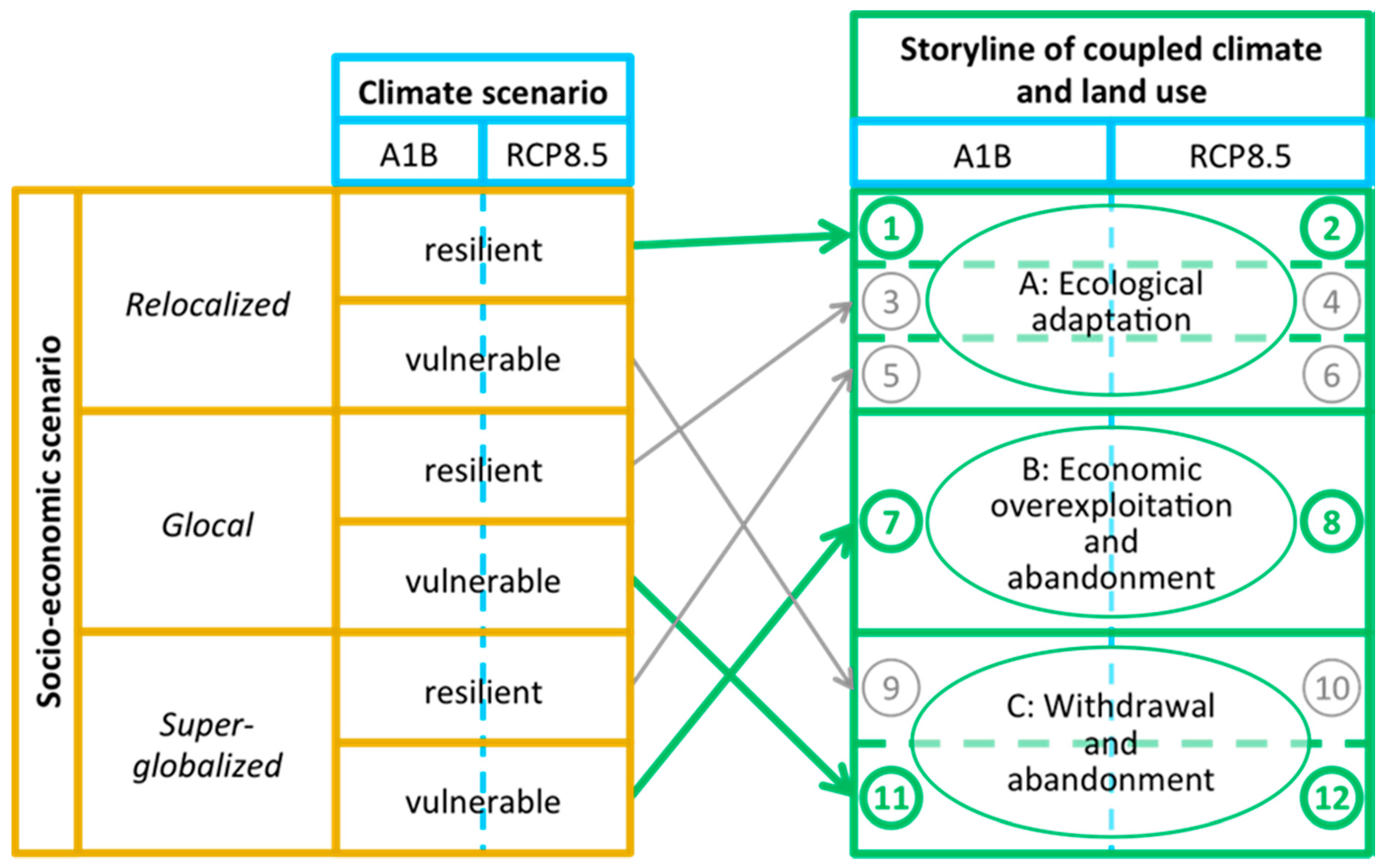
48] to structure the written text into different categories. The main categories were factors influencing forest management (ownership status, climate, tourism, and economy, as well as topography being the most important). As a result, we identified more than 140 statements on issues of forest management, which we tested in an online survey sent to all forest owners (n = 902) in the study area. Even if the response rate was low (7.1%) due to problems with email addresses (We had planned first to contact the forest owners by e-mail. However, for reasons of data privacy, we had to send a formal letter with a link to access the online survey.), this feedback added to the scenario. Most of the respondents claimed to manage the forest themselves, and only a few employed companies. In general, they did not envisage intensifying their forest management, however, more than half of the respondents planned to increase their forest area, mostly by afforesting agricultural land. Although presently the average contribution to their income was estimated as being only 10%, they expected the importance of forestry to increase. Supplementing the deductive framework with the results of our empirical investigations allowed us to construct vulnerable and resilient narratives each for the three economic trajectories. We combined the resulting six socio-economic scenarios with the two locally downscaled climate scenarios (
Figure 3, left side), which added up to 12 possible narratives of future development—the so-called storylines.
We discussed the storylines in a first participative [
49,
50] workshop with local representatives of different stakeholder groups on their consistency and plausibility. In a next step, we discussed their consequences for land-use change and forest management with two experts from the district and provincial forestry departments. As some of the storylines turned out to have quite similar consequences on land use, we reduced the six socio-economic scenarios to three distinct pathways of forest management, namely: (A) ecological adaptation, (B) economic overexploitation and abandonment, and (C) withdrawal and abandonment (
Figure 3, right side).
- (A)
Ecological adaptation: Forest management consistently applies the guidelines outlined in the forest development plan (“Waldentwicklungsplan”) issued by the federal ministry. The forest cover is dominated by an ecological, place-adapted mixed cultivation with a harmonious age structure. This makes the forest generally resilient to natural hazards while it continues to fulfil its different functions. Marginal land on steep slopes is reforested, mountain pastures are used for cattle and sheep as today. Natural reforestation is partly possible due to extensification which is already ongoing. This represents a socio-economic scenario of resilient relocalization. The communities act innovatively and proactively. They favour, for instance, the use of local wood chips for communal heating systems and coordinate the supply chain for quality timber in the hands of local craft businesses. Climate change is perceived as an opportunity to act in coordinated fashion towards a sustainable future. Local supply chains and eco-tourism (mainly for summer tourism) retain the value added locally. Agriculture makes optimum use of the prolonged vegetation period, diversifies the product range and, in combination with local off-farm employment possibilities, slows down structural change. Mountain summer farms specialize on the provision of local food to tourists, along with animal herding, thus most of them continue in operation.
- (B)
Economic overexploitation and abandonment: Management is guided by short-term economic considerations, and results in a focus on increased efficiency and cost reduction at the expense of long-term ecological considerations. Nevertheless, legal regulations are respected and new, adapted, species are reforested (e.g., Douglas fir). After a short intensive phase of forestry use and overexploitation, the actors lose their economic interest in the forest as profits decrease. The storyline is based on a vulnerable super-globalized scenario, which assumes that policy is following a pronounced neoliberal line of thinking, allowing the global market to dictate the decision-making processes. Actors do not cooperate at a local level and global investors exploit resources for as long as it is profitable before abandoning the marginalized region. The touristic potential decreases, as it is still based on winter tourism and is not adapting fundamentally to climate change. As the timber industry is not very innovative, it has little success on the international markets. Farming retreats from unfavorable locations, especially from the mountain pastures. There is a general decline in agriculture, only a few large competitive farms remain. The abandoned areas in the valleys are used for fast growing timber species. Only few mountain pastures are still used for sheep and young stock, and in general, bush encroachment prevails. Forests are first overexploited, and then abandoned.
- (C)
Withdrawal and abandonment: Forest management in general decreases. With the withdrawal, the forest becomes vulnerable to natural hazards. Mountain pastures are almost completely abandoned. The underlying vulnerable glocal scenario envisages that land owners generally withdraw and abandon their management activities. Government enforces climate adaptation without the participation of local stakeholders. There are no trusted relationships among local actors, resulting in a lack of cooperation and an increasing dependency on traditional top-down governance structures. Tourism and local enterprises stagnate, and the young people educated outside the region do not come back. Agriculture is on the decline and government provides incentives for exit strategies and rapid structural change. Mountain pastures remain only very selectively used, which, under the given topographic conditions, leads to massive succession, first by green alder, and finally by the neighboring coniferous species.
The two forest experts also provided figures to these pathways, which allowed for translating the qualitative storylines into numerical rules so as to produce transient land-use maps with the help of geographical information system (GIS) operations. On the basis of these maps, the hydrological impacts of the three management pathways were calculated for the moderate and extreme climate scenarios using the physically-based hydrological model WaSiM [
51]. This model describes the water flows from the atmosphere through the vegetation to the ground and into the soil, and finally along the river to the gauge at the outlet of the catchment. WaSiM has already been used successfully in a wide range of applications [
52,
53,
54]. The hydrological processes are computed on a regular grid in hourly or daily increments. The newest model version includes snow interception, accounting for intermediate snow storage inside a forest canopy [
55]. Thus, the new WaSiM version is specifically designed for application in high mountain regions. In catchments with forest cover, the water balance is affected by the interception of precipitation (both solid and liquid) on the leaves or needles, the branches, and the stems of the trees inside the canopy. Depending on the climatic conditions, the intercepted snow is subject to high sublimation rates. Although the amount might be low compared to the summer transpiration, snow sublimation adds to the total annual water fluxes from the canopy back into the atmosphere. The remainder is released from the branches as the melt water or mass unload, leading to highly non-uniform snow depth patterns underneath the canopy [
56,
57]. These effects are included in the new model version.
5. The Relevance of the Results for Local CCA Strategies
Before discussing the relevance of the results, we want to summarize once again the integration of non-academic stakeholders into the research process (
Table 2).
The workshop participants were selected to represent the key actor groups for land use (e.g., regional development, tourism, agriculture, and forestry). External staff were used to facilitate both of the stakeholder workshops. This allowed for the researchers to share their opinions and to converse with the non-academic stakeholders at eye-level. The first stakeholder workshop aimed to validate the storylines in terms of consistency and plausibility. We presented the combined scenarios to 15 non-academic stakeholders in two groups, one focusing on socio-economic scenarios under the moderate climate change conditions, the other on the same trends in the drastic RCP 8.5 scenario. The stakeholders discussed the underlying socio-economic trends and provided in depth knowledge on the local conditions and dynamics needed to refine the storylines. Overall, they considered most of the features plausible and consistent. They unanimously agreed on the mutual interdependence of agriculture and tourism, but were surprised by the speed of climate change proposed by the scenarios. However, sometimes they did not refer to the consistency of the storyline, but rather discussed the probability. For instance, they doubted that a reliance on gentle and eco-tourism could be a viable strategy.
The consultation of forest experts from a district and provincial level started with a discussion about the effects of the storylines on land-use changes. This led to three distinct pathways of forest management for each climate scenario. Each pathway was connected to a certain socio-economic scenario (see again
Figure 3). Apart from forest management, we discussed the consequences for the management of mountain pastures with them. The experts were able to provide detailed data on the consequences for species composition, according to their forest management plans. This was crucial information for calculating the transient land-use maps, which in turn were the basis for the hydrological modelling.
While the participation of non-academic stakeholders in the research process so far was primarily necessary for us as a research team to get a consistent basis for hydrological modeling, the discussion of the storylines and the subsequent modeling results provided a basis for the stakeholders to develop local CCA strategies. In particular, the second stakeholder workshop contributed to the future implementation of the results. We invited the same group as that from the first workshop. Out of the 15 stakeholders who attended the first workshop, six participated in the second workshop. The overarching aim was presenting and discussing the project results, as well as reflecting on the project process. The transient land use modelling and the results of the hydrological modelling served as a way for them to better understand the climate impacts under different socio-economic development options. Furthermore, the discussions centered on how stakeholders perceived their integration into the research process, as well as how the results could be of use for their professional activities and for local/regional development strategies.
Discussing the hydrological results helped the local stakeholders to better understand the larger-scale forces affecting their communities [
11]. At the beginning of the second workshop, the stakeholders asked for the clarification of details and raised some methodological questions, for example, how we had calculated the future reduction of the mountain pasture area. In general, they commented that the results provided a holistic picture. They were impressed to see that there were significant differences between the storylines concerning water availability. What struck them particularly were the negative consequences for water availability of a further increase in forest cover, in combination with new users and increasing water consumption. The hydrological results indicate that different pathways or trajectories of regional agricultural development have a measurable impact on potentials of resource use. The participants realized that the socio-economic trends, which could be influenced, at least to some degree, by local and regional decisions, may intensify or reduce the effects of climate change. An improved knowledge of long-term consequences defines and increases the scope of action by local stakeholders. In particular, the role of the agricultural stakeholders shifted from passive recipients of measures, designed and specified by others, to active participants, in defining which practice would be both feasible and effective in their specific context [
62].
Furthermore, the participants in the second stakeholder workshop discussed whether the results could be transferred to other mountain regions in the Alps, and expected that areas less fortunate in precipitation would experience even greater problems. Therefore, they recommended disseminating the project results widely within the region in a non-scientific way. In particular, representatives from the District Chamber of Agriculture and from regional development acknowledged a responsibility for themselves to initiate and push this dissemination process. For them, the detailed storylines of land-use change served as clear illustrations of possible futures, highlighting the interconnections between various forms of capitals acting on different stakeholder groups. Therefore, they proposed to present the results in a meeting to a wider audience, specifically to agricultural, spatial planning, and tourism institutions, as well as to mayors in the region. For them, management option (A) (ecological adaptation) represented the most favorable trajectory, not only with respect to mitigating the reduction of streamflow, but also concerning the future continuity of traditional agricultural practices, like transhumance on mountain pastures. Agricultural stakeholders obviously perceived the results as a chance to strengthen the role of agriculture for rural development. The storyline underlying management option (A) (ecological adaptation) serves as a concrete guideline for proposing a future collective territorial development strategy. For further non-scientific dissemination, the research team was invited to present the results to the district board of the chamber of agriculture in early February 2018. In the discussion on that occasion, the district board envisaged to continue making regional stakeholders aware of the consequences of the combined effects of socio-economic and climate change, and of the possibilities for counteracting them. Recently, another district chamber (from a region with less annual precipitation) also approached the research team to discuss the relevance of the results for their region.
These first steps to a collective CCA process were enhanced by the focus of the research on land-use change and systemic interdependencies, and not on the individual practices of the farmers. Different forms of climate-change adaption appear. Grüneis et al. [
7] distinguish first-generation adaptation from second-generation adaptation. According to them, first-generation adaptation aims at particular measures for particular problems of climate change [
63], while second-generation adaptation offers a more comprehensive view that addresses the context [
64] and frames the adaptation more in the sense of sustainability and resilience. In this respect, we can understand a collective territorial development strategy as a second-generation strategy.
The storylines provide a holistic picture of the potential future land-use evolution as basis for the development of local adaptation measures to climate change. They allow for overcoming the focus on socio-economic changes as immediate triggers for policy intervention. Land-use change by conversion of mountain pastures to forest has a slow but long-term effect, similar to climate change. The storylines provide a concrete vision for the region, and the hydrological results describe the potential of local intervention. The participants got a sense of their options to adapt locally to a global phenomenon.
6. Recommendations and Limitations for Future Transdisciplinary Research Projects
Compared with the ideal type of a transdisciplinary research process [
25], we applied a lighter version. Our project started with a classic scientific research question and methodological approach. There was no possibility to frame the research problem collaboratively between the scientific and non-academic participants. Our assumption was that a complex set of impact factors on global and local levels, besides climate change, including economic and societal changes, had to be taken into account in order to project future land-use changes. It was clear that this would require the integration of local lay and professional knowledge in different ways, so as to supplement scientific knowledge. However, in the process, it became ever clearer that our storylines could not only serve the hydrological modelling in a strict natural science sense, but they could also have the potential to act as tangible images of possible future paths of development. The modelling results help to understand complex interdependencies and to determine the scope of local action. This may serve as the basis for collective long-term strategic CCA decisions. Thus, the approach may have an empowering effect for the local stakeholders. Similar to earlier transdisciplinary research projects [
25], here too, some factors of successful integration of non-academic stakeholders emerged.
Firstly, the roles of all parties involved should be clearly delineated. In our case, scientific research provided evidence of climate change and a theory-based framework for socio-economic interactions. Non-academic professional experts provided input with their practical knowledge of the effects of climate change on forest composition. Local stakeholders shared their experiences assessing the consistency and plausibility of the storylines presented. Then, the scientists calculated the results and presented them for collective evaluation, and provided suggestions on how to translate them into activities.
Secondly, the practical applicability of the results is crucial. The storylines created represent tangible visions of possible futures, which go beyond the visualizations of land-use changes and reveal the complex underlying reasons, trends, and drivers, and their interdependences. Discussions on the effects in a long-term perspective, especially, can result in a deeper understanding of the systemic interdependencies. At the same time, the underlying storylines should provide a concrete picture of a desired future, and the results indicate the scope of action for local stakeholders.
Thirdly, the results should open possibilities for local intervention. In our case, the effects of different forest covers revealed the scope of local human intervention in the global change processes. This had an empowering effect on the local participants, together with the improved knowledge about the systemic interdependences of various factors.
Fourthly, the scientific part of transdisciplinary research projects should not stop with presenting and discussing the scientific results, but should continue by supporting and monitoring the transformation process. Such a claim, however, requires a new design for transdisciplinary research, extending from analyzing the processes of socio-ecological transformation, to accompanying transformative processes. Recently, the Austrian Climate and Energy Fund announced a call for so-called model regions for climate-change adaptation (Klimawandel-Anpassungsmodellregionen (KLAR!)). As the same fund supports research on climate change (for instance, the project which generated the data for this paper), it would be logical to concentrate on the inter- and trans-disciplinary research on climate change processes in these regions, and to combine it with transformative research, into the implementation of climate-change adaptation processes.
Although the interaction of scientific, professional, and local stakeholders in this study can be considered as positive, the research design in itself suffered from some limitations and flaws. In particular, we experienced problems with participation in the quantitative online questionnaire and in the attendance of the second workshop. For the online survey, we had envisaged, first, to invite the forest owners by e-mail. However, for reasons of data protection, e-mail addresses were not available, so we had to resort to sending a formal letter to every forest owner, providing a link to complete the online survey. This complicated procedure limited the response rate considerably.
Participative approaches rely on the engagement of their stakeholders. As already explained, the design of the project did not allow for including stakeholders in the framing phase prior to the actual coproduction of knowledge. This may have reduced the identification of non-scientific participants with the project. Moreover, it is a recurrent problem that stakeholders usually expect results faster than the scientific research is able to deliver. Thus, the time gap of about one and half years between the two stakeholder workshops might have been too long.
Apart from the limitations of the model and the scenarios, the project site in itself represents an area where no resource limitations have been experienced so far. Stakeholders agreed that the results might be more dramatic in regions with less precipitation. However, the study has developed a procedure that may be replicated (and probably improved) in further projects in other parts of the Alps.

 ,
, 


