Article

The Khandaq Shapur: Defense, Irrigation, Boundary, Frontier

1
Archaeology Department, Durham University, South Road, Durham DH1 3LE, UK
2
Department of Archaeology, University of Al-Qadisiyah, Diwaniyah 58001, Iraq
3
Department of Cuneiform Studies, University of Al-Qadisiyah, Diwaniyah 58001, Iraq
4
Department of Geography, University of Thi-Qar, Nasiriayh 64001, Iraq
*
Author to whom correspondence should be addressed.
Submission received: 31 August 2021 / Revised: 23 September 2021 / Accepted: 24 September 2021 / Published: 28 September 2021
(This article belongs to the Special Issue Land Use in Archaeology)

Abstract

:
Khandaq Shapur has been named one of the great barriers of the ancient world, but very little is known about the monumental-scale linear feature. This interdisciplinary paper brings together archaeologists and historians to present (1) an updated history of the Khandaq Shapur drawing upon a wider range of sources, including Arabic scholarly sources, and (2) a modern map of the Khandaq Shapur produced from a ground truthed remote sensing using historic Corona satellite imagery from the 1960s and imagery available in Google Earth. This new map of the Khandaq Shapur’s ground truthed location is compared to the known locations of Sasanian sites from previous archaeological surveys to contextualise the Khandaq Shapur within the wider archaeological landscape. Together, the landscape archaeology and historical evidence provide a comprehensive picture of this unique feature: shedding light not only on its precise location, but also its nature (what was it?) and how it was used over time.

1. Introduction

The Khandaq Shapur is considered one of the great barriers of the ancient world [1,2]. Also known as the Kari Sad’eh (كري سعدة) and better known locally as the Nahr al-Alqami (نهر العلقمي), the feature plays a central role in the foundation of Shiite Islam [3]. Despite its significance, little is known about the full history. It is primarily known from three points in time: (1) its foundation under Shapur II in A.D. 324, (2) its re-use under Khosrow I/Chosroes Anushravan (A.D. 531–579) during the mid-6th century A.D., and (3) as the location of the Battle of Karbala in A.D. 680 [4,5,6,7]. In Iraq, however, it is common knowledge that the Khandaq Shapur was first excavated by Nebuchadnezzar II (r. 604–562 BC) and that the feature was only reused by Shapur II (309–379 A.D.) [8].
Historians that attribute the foundation of the Khandaq Shapur to the reign of the Sasanian ruler Shapur II (309–379 A.D.) base their attribution on historical sources that describe the excavation of the feature in A.D. 324 [7,9], [10] (p. 485), [11] (p. 138), [12]. Shapur II was enthroned as an infant and the excavation of the Khandaq Shapur was one of the first tasks he undertook at the age of 15 when he first took practical, administrative control of the empire [9] (p. 73). It is possible he also constructed forts or a rampart along the Khandaq Shapur [11] (p. 183), [13]. The general purpose of the Khandaq Shapur was to protect the irrigated alluvial plain controlled by the Sasanians from Bedouin or Arab tribes—some allied to the Romans—in the desert to the west and keep them out following expulsion and a program of resettlement [9,10], [11] (p. 139), [12] (pp. 8–10), [14,15].
The extent of the Khandaq Shapur in the 4th century A.D. under the reign of Shapur II is unclear. Shapur II may have organized the excavation of the Khandaq Shapur between Hit and Basra [7] (p. 65), but it is also possible that Shapur II only excavated the southern portion of the Khandaq Shapur, south of Abu Sakhair [16] (see Figure 1), and that Khosrow I (also known as Chosroes Anushravan) extended the Khandaq Shapur to its full length between Hit and Basra [2,12].
What is certain is that for Khosrow I, the Khandaq Shapur was just one part of a much larger system of defensive features around the Sasanian Empire that he fortified, including the fortification of a key passage through the Caucasus and the Gorgan Wall [9] (p. 77), [16]. It is less certain if Khosrow I first fortified the Khandaq Shapur, or if the Khandaq Shapur was fortified already when it was first excavated by Shapur II [12] (p. 11). Later, historical sources also describe that Shapur II constructed ‘long walls’ in addition to the Khandaq Shapur [9] (p. 73), and at least one modern historian argues that Khosrow I only added to and improved the fortifications [12] (p. 15).
Furthermore, the precise nature or character of the Khandaq Shapur is uncertain from historical sources. Through its Sasanian history during the reigns Shapur II and Khosrow I, the Khandaq Shapur is variously described by historians as a ditch, trench, moat, and canal in English-language publications [1,5,6,7], [10] (p. 485), [13] (p. 603). This ambiguity lies in the translation of the Arabic word khandaq (الخندق), which does not have an exact translation into English [17,18]. Essentially, when the word khandaq refers to a landscape feature, it is a monumental-scale linear feature created by excavation that might (moat, canal) or might not (ditch, trench) hold water.
The Khandaq Shapur is only one of many khandaqs known from history. Other examples of khandaqs are known near Baghdad (Khandaq Khosrow—[2], Khandaq Karch Baghdad—[19] (pp. 224–226)), Medina (the Battle of Al-Khandaq or Battle of the Trench – [13] (p. 611), [20] (pp. 33–35), [21]), Cairo (Khandaḳ al-Abid—[22]), and Tunis (Khandaq Maymun—[23]), where the term khandaq may also refer to set of trenches used as open sewers [24]. On Crete, Heraklion was referred to as al-Khandaq in Arabic in reference to a fortified camp with a moat constructed in A.D. 961 [25]. The varied nature and much smaller dimensions of these other khandaqs does not add any clarity to the precise nature or character of the Khandaq Shapur during the Sasanian period.
By A.D. 680, the Khandaq Shapur had become the Nahr al-Alqami. In the Battle of the Trench, the Khandaq Shapur/Nahr al-Alqami serves as a meeting location near Karbala between competing successors to Mohammed’s legacy and as source of water [3]. The new name (nahr is the Arabic word for river) and the role the feature plays in the Battle of the Trench both indicate that the Khandaq Shapur was a linear water feature similar to a canal by A.D. 680.
Archaeologists and ancient historians examining descriptions within classical sources have realized that the Khandaq Shapur may be a re-excavation and possible extension of an irrigation canal dating to the Neo-Babylonian period called Pallukat or Pallacottas [26] (p. 24). Cuneiform texts record the excavation of trenches (iku, eku, or igu), ditches (birītu), and moats (hirītu or harīsu) from the third millennium B.C., and particularly from the mid-third millennium B.C. Jacobsen [27] (p. 177) and Cole [28] (pp. 7–8) equate the Pallacottas canal with the Apkallatum canal (also known as the Aplakattu canal) in texts, but neither relate the Apkallatum/Aplakattu canal to the Khandaq Shapur or the Sasanian period. Adams’ famous map series and study of irrigation channels in Heartland of Cities does address later time periods including the Sasanian period, but neither Heartland of Cities nor his earlier survey of watercourses include the immediate vicinity of the Euphrates north of Samawah where the Khandaq Shapur is located [29,30]. More recently, an archaeological remote sensing study produced a preliminary map of the Khandaq Shapur [14,31]. This paper combines expertise from landscape archaeology and cuneiform studies to improve the existing map of the Khandaq Shapur and explore the possibility that the Khandaq Shapur may be a re-excavation of an earlier, Neo-Babylonian canal, perhaps dating to the reign of Nebuchadnezzar II.

2. Materials and Methods

This research was conducted in two stages. First, a landscape archaeology study that aimed to extend the existing map of the Khandaq Shapur, ground truth the mapped course of the Khandaq Shapur, and contextualise the Khandaq Shapur within the wider Sasanian landscape. Second, a historical study drawing on evidence from cuneiform texts to better understand the full history of the Khandaq Shapur beyond a few famous moments in time.

2.1. Landscape Archaeology

The digital file for the pre-existing map of the Khandaq Shapur, published in both Jaafar Jotheri’s Ph.D. thesis [31] and the volume Sasanian Persia [14] (Figure 1) was overlaid on top of Corona imagery from the 1960s and additional sections of the Khandaq Shapur were sought. This Corona imagery included images from an earlier mission (9050), which took place 14 December 1962. This early imagery was particularly critical for locating potential additional segments near urban centers such as Karbala (كربلاء), Najaf (نجف), and Kufa (كوفة), which have all expanded in the intervening decades (Figure 2).
Additionally, a topographic survey using a handheld GPS (Garmin eTrex 20) was conducted around the shrine area in Karbala to determine if any evidence remained of the former location of the Khandaq Shapur as a depression through the city. Elevation was recorded at 33 points around the holy shrines of Imam Hussein and Imam Abbas, and a further eight points at the historic location of Imam Hussein’s camp ahead of the Battle of the Trench. No evidence of a linear depression was found in the topography of either location. In fact, the ground consistently rises slightly towards the shrines where a polished marble plaza has been constructed to between the shrines of Imam Hussein and Imam Ali (Figure 3).
For the ground truthing survey, Jaafar Jotheri and Michelle de Gruchy drove between Karbala and Najaf along Highway 9, which runs parallel to the mapped course of the Khandaq Shapur and turned off the highway regularly to find the Khandaq Shapur using the remotely sensed map of the feature, Google Earth, and GPS to navigate. At each location between Karbala and Najaf, we would park the car near the mapped location of the Khandaq Shapur and walk on foot to locate the channel, talking to any local residents as it is well known to them. Near Karbala, Najaf, and Kufa the channel was easily identifiable (Figure 4). North of Karbala, we were unable to locate evidence of an artificial channel beyond the village of Shuwaya within the limited area that we searched, nor did we try to ground truth the remainder of the Khandaq Shapur map to its origin near Hit due to security concerns. South of Najaf to Basra, Jaafar Jotheri and Raheem Alabdan used the same approach of driving, stopping, and walking to ground truth the southern portion of the Khandaq Shapur.
The most difficult and time-consuming section to locate was the long straight segment between Khan an Nukhaylah (خان النخيلة) and Hayderiyah (حيدرية). On the ground, we quickly learned from an older farmer that the straight feature identified in imagery corresponded to a former rail line that was removed in the 1960s. Instead, he showed us the location of a channel about a kilometre to the east and suggested that might be the one we were looking for. We recorded the location with our handheld GPS. Over the following weeks, as we continued to ground truth and review the imagery further, the farmer’s suggestion proved to be the most sensible alternative to the old rail line, neatly connecting the segments north of Najaf and Kufa to Hayderiyah and south of Karbala to Khan an Nukhaylah. Lastly, we collected radiocarbon samples (freshwater shells) from two trench locations (J2 and J3) in the section between Karbala and Najaf (Table 1, Figure 5). These trenches were excavated mechanically to expose the cut of the Khandaq Shapur (Figure 6 and Figure 7). In both locations, the samples were collected from the base of the fill inside the cut of Khandaq Shapur.
Figure 5. The Khandaq Shapur and Sasanian sites over a 90 m resolution SRTM digital elevation model. The sites are clustered into two large patches where Adams [29,32,33] conducted his surveys and along the Khandaq Shapur where Jaafar Jotheri, Raheem Alabdan, and Michelle de Gruchy surveyed sites along the mapped course of the feature. Notably, the Khandaq Shapur follows the edges of two alluvial fans.
Land 10 01017 g005

2.2. Cuneiform Studies

Over several months from 2020 to 2021, members of the team with expertise in cuneiform studies, searched the Cuneiform Digital Library Initiative (CDLI, www.cdli.ucla.edu (accessed on multiple occasions between January and August 2021) for evidence of a channel/canal/ditch/trench following the course of the Khandaq Shapur. Unfortunately, previous publications either do not list which cuneiform tablets are supposed to evidence the construction of the earlier channel [34] (p. 117) or reference an unpublished tablet they viewed with permission from a private individual [35] (pp. 20–21). In another source, a pair of cuneiform tablets (Nbn. 506 and Ner. 18) that have previously been used to evidence the northern course of the Pallukat or Pallacottas‘report the delivery of barley and the payment of tithes to the Ebabbar’ [36] (p. 149). Nonetheless, it was hoped that the searchable format of the CDLI would facilitate identifying any published tablets that might contain any evidence of any earlier linear feature the Khandaq Shapur may have re-excavated.

3. Results

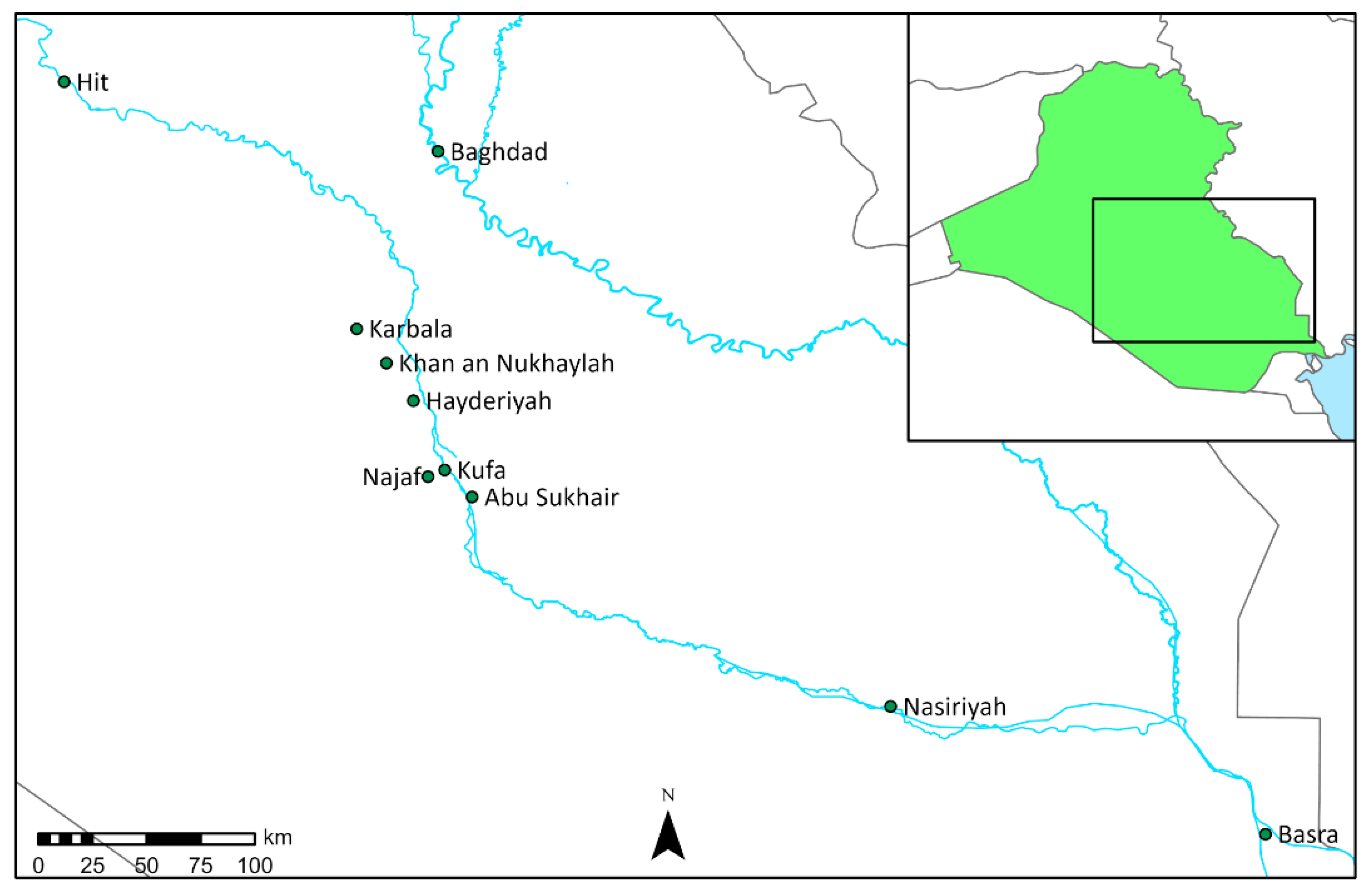
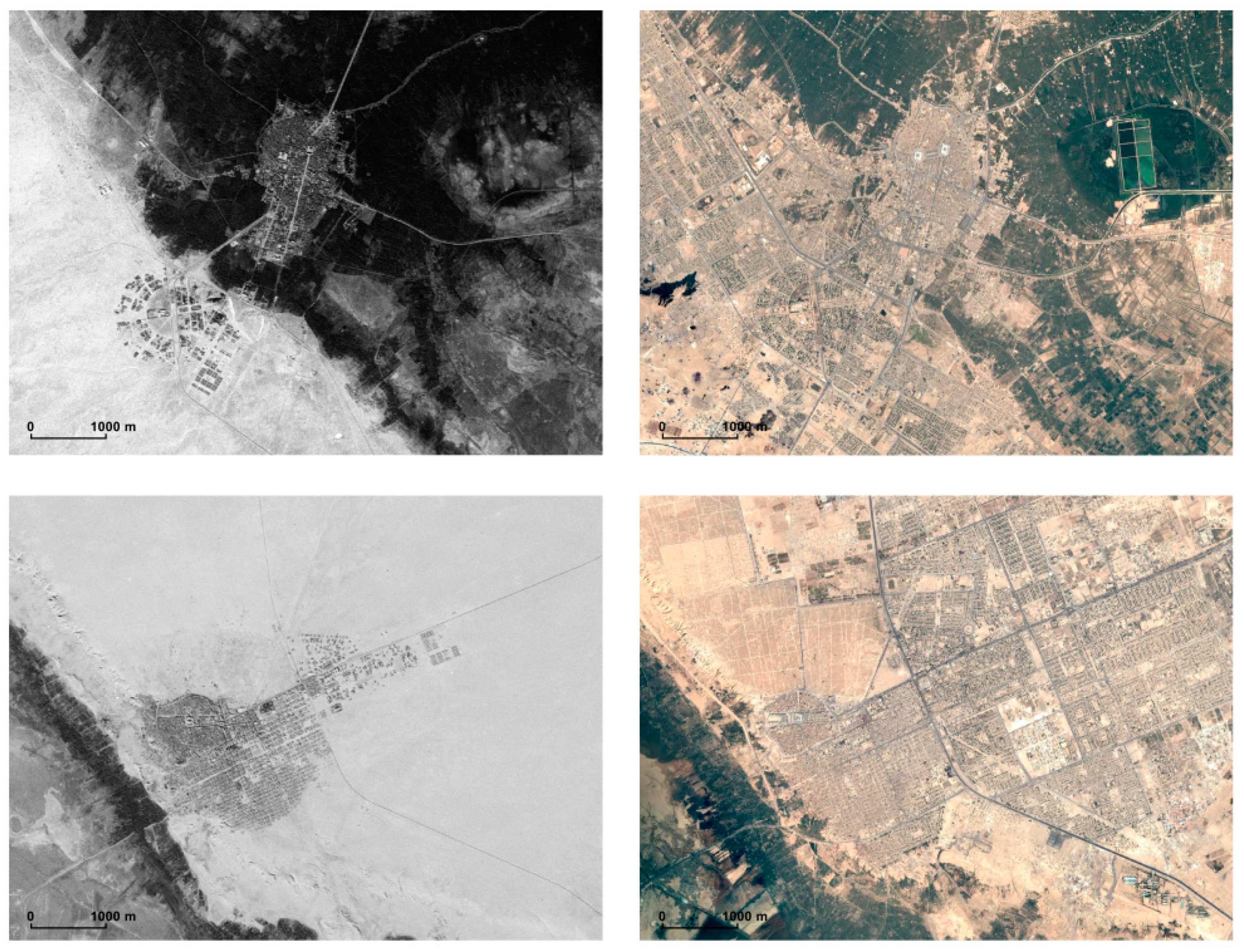
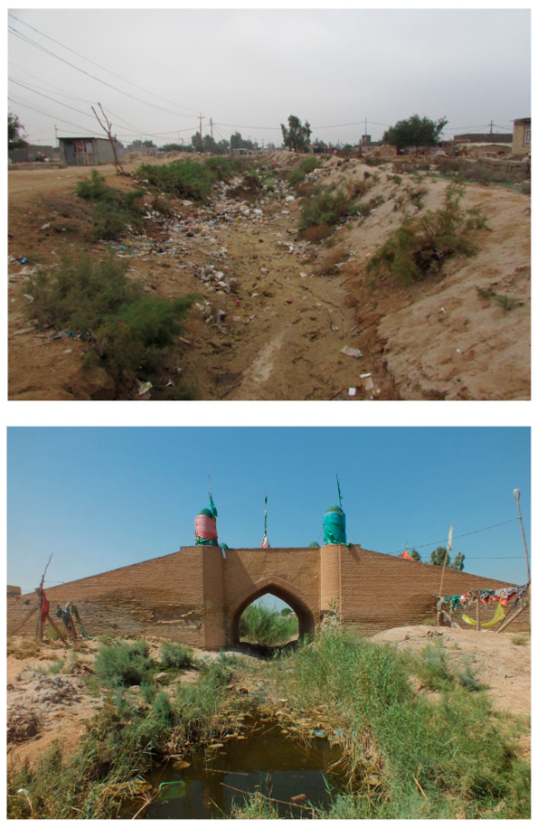
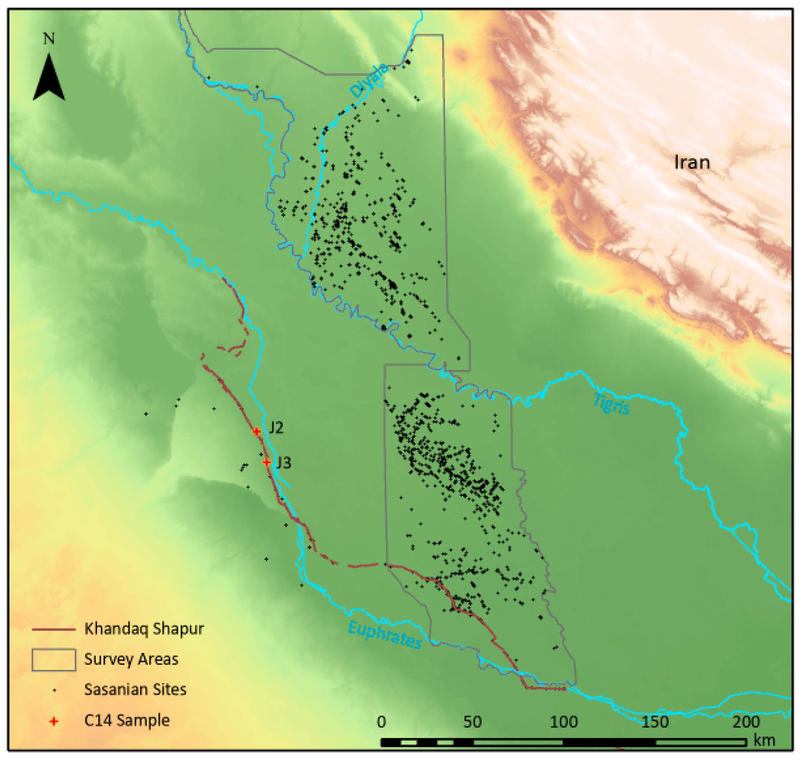
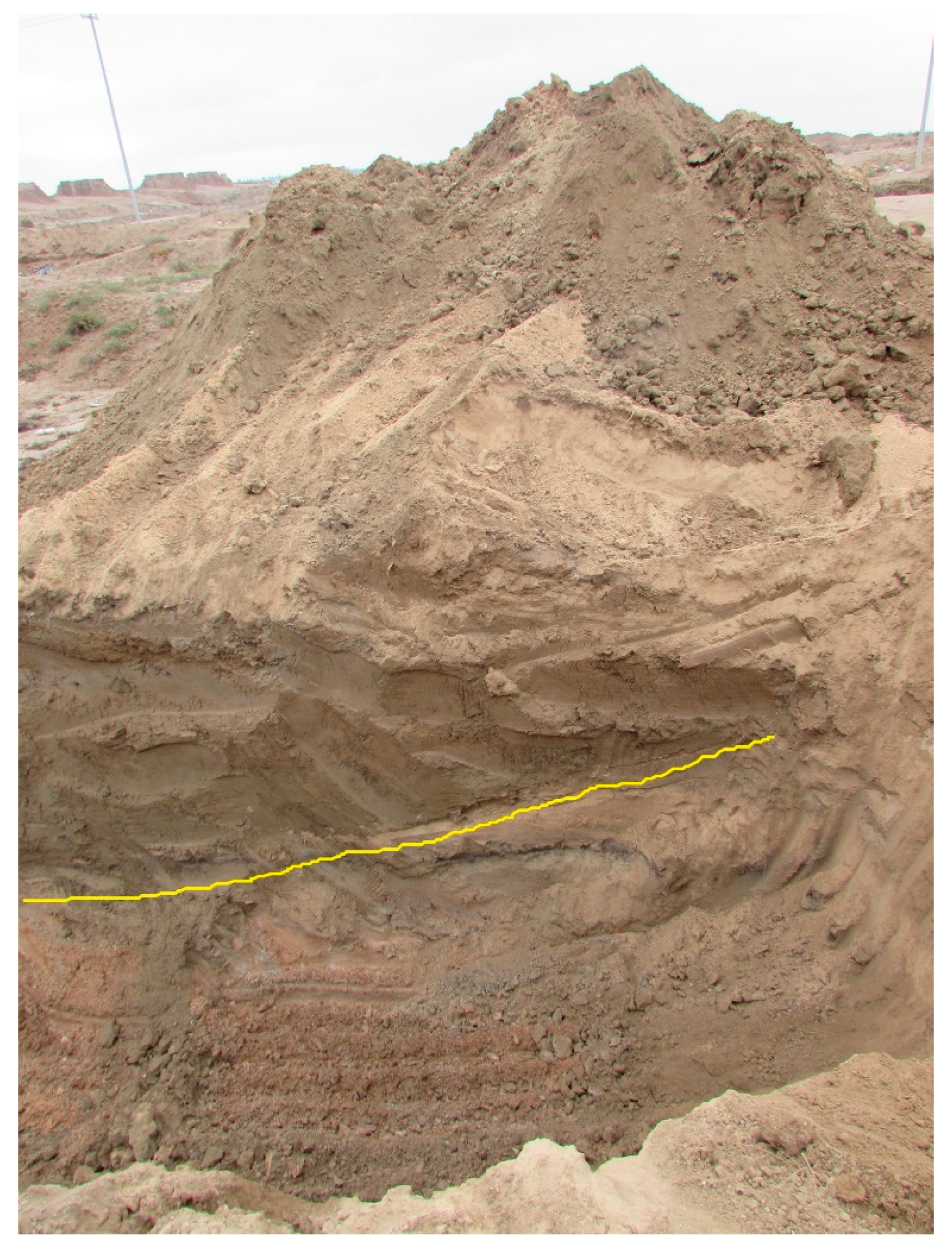
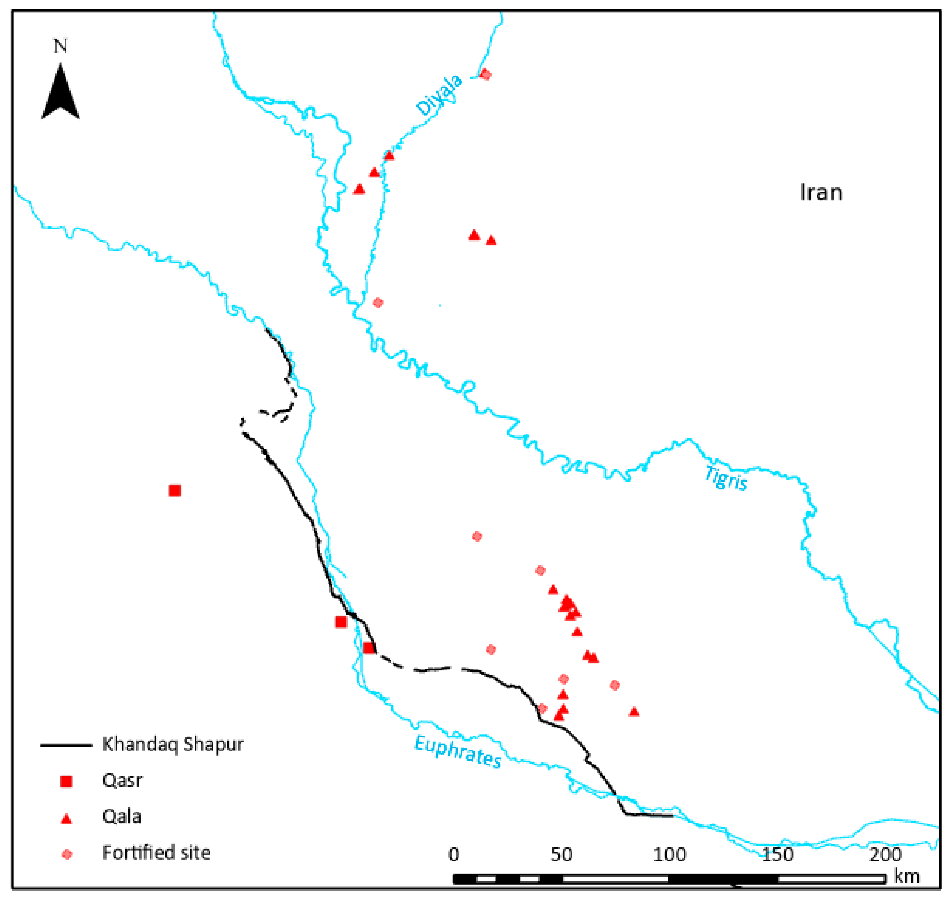
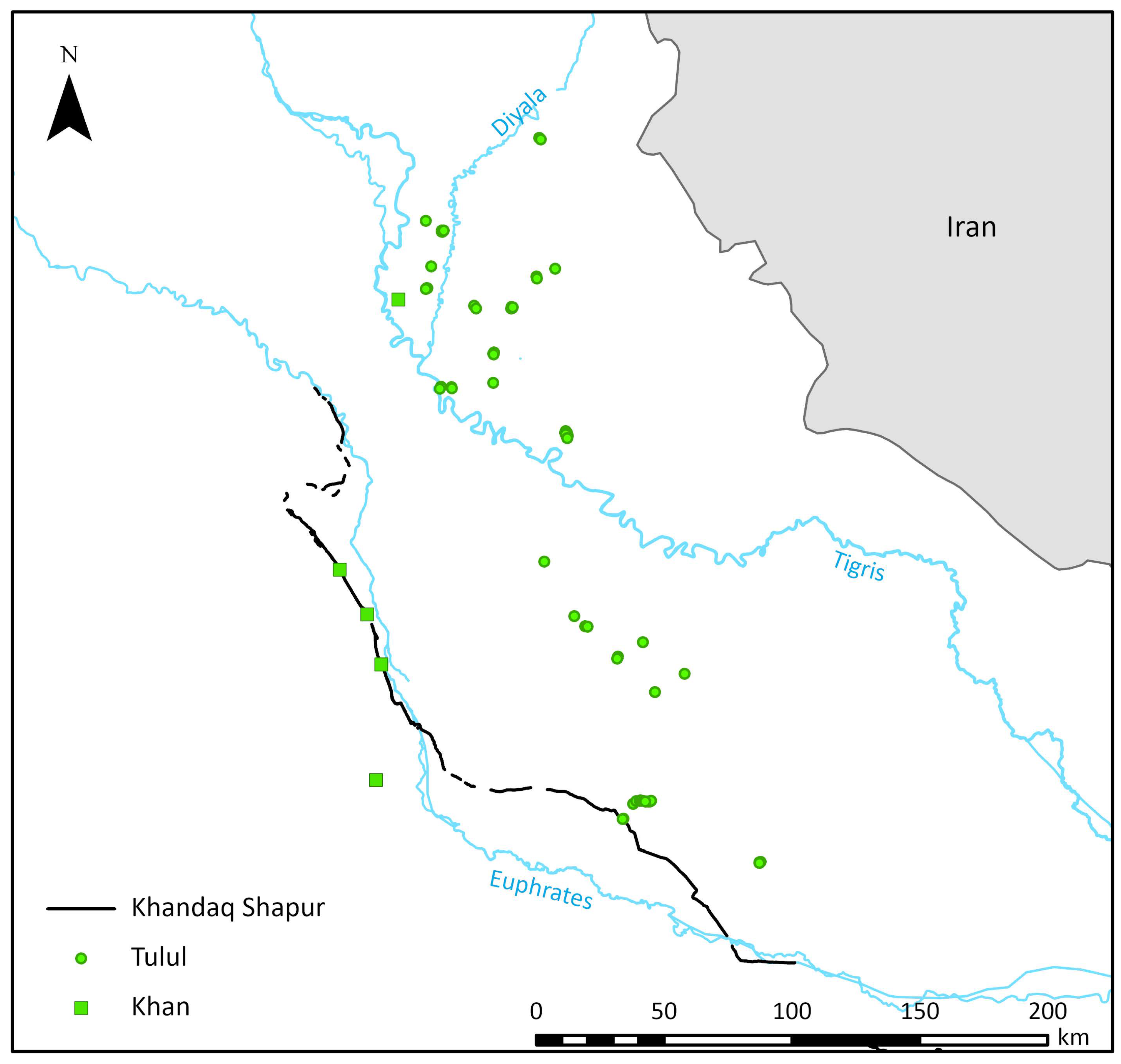
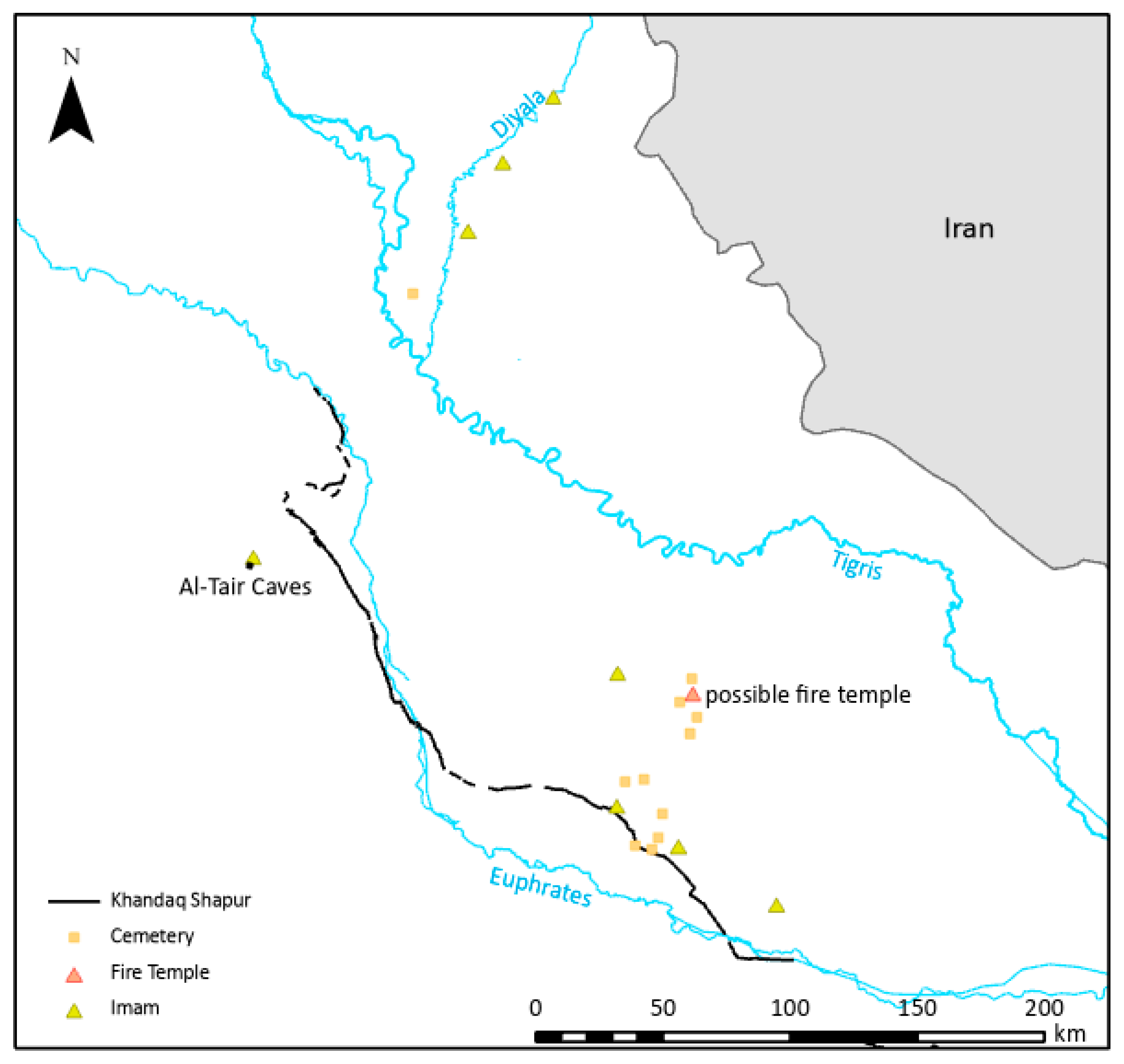
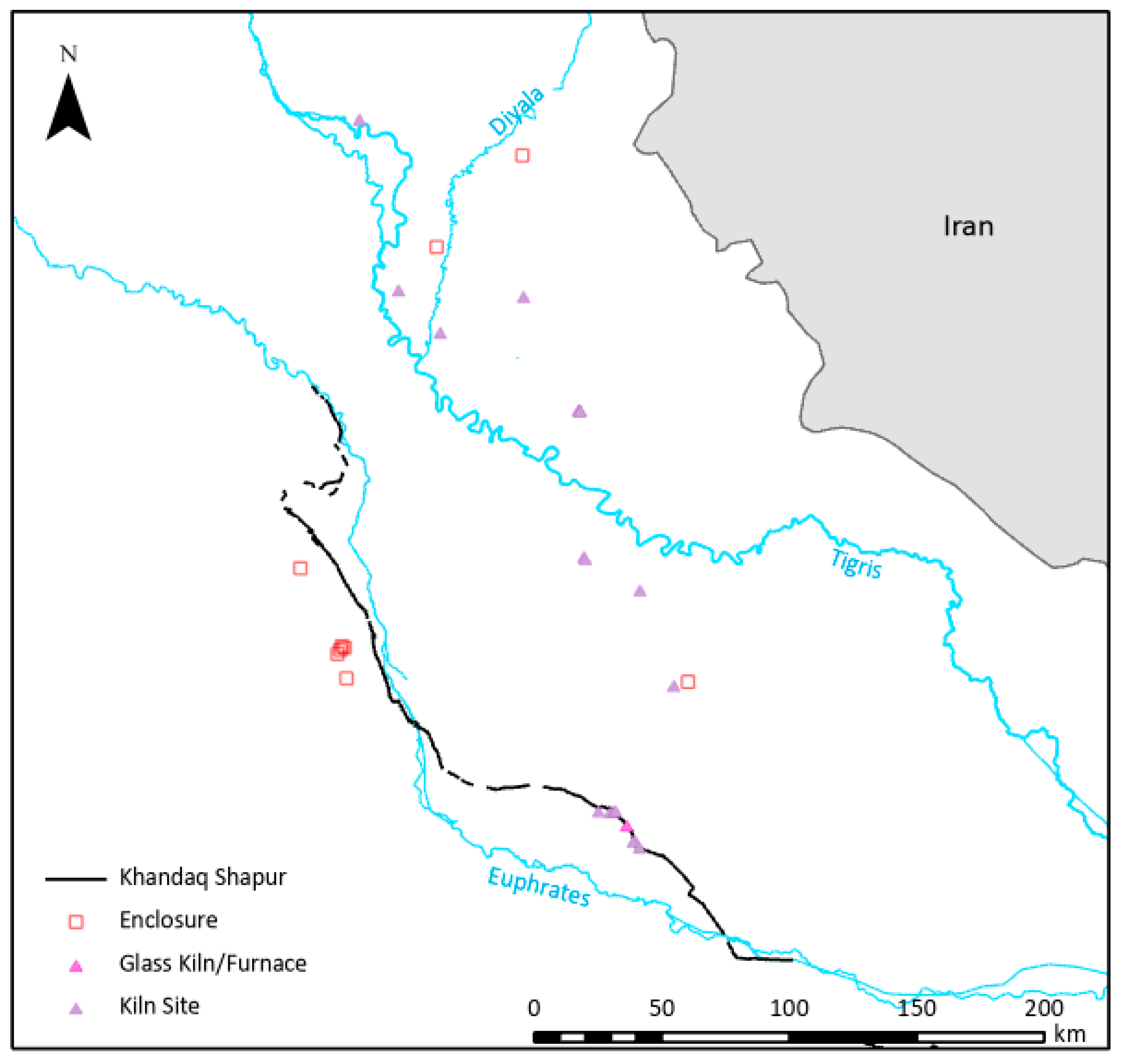
3.1. Landscape Archaeology

The ground truthed course of the Khandaq Shapur was imported into ArcGIS and mapped alongside Sasanian sites surveyed by Adams [29,32] and Adams and Nissen [33], as well as other known Sasanian sites mapped by Lawrence and Wilkinson [14], and observed by Jaafar Jotheri and Michelle de Gruchy while driving along Highway 9 and surveying the Khandaq Shapur (Figure 4). The updated map of the Khandaq Shapur still traces the boundaries of the alluvial fans north of Karbala and to the west of Karbala and Najaf, as published in Lawrence and Wilkinson [14]. The corrected segment between Khan an Nukhaylah and Hayderiyah more neatly follows the edge of the alluvial fan west of Karbala and Najaf, called Al-Khir, than the previously mapped segment in that location, although that difference is not visible in print. A digital copy of the new, updated map is included as a Google Earth file (KhandaqShapur.kmz) in the Supplementary Materials.
This northern half of the Khandaq Shapur between Hit and Kufa was dug between the western desert and the floodplain, mainly in the coarse red sand and gravel of the desert. While south of Kufa, the newly mapped southern portion of the Khandaq Shapur deviates from its neat path along the edge of desert and turns eastward to within the area floodplain.
To better understand the nature of the Khandaq Shapur and contextualise it within the wider landscape, the newly documented extent of the Khandaq Shapur was mapped alongside all known Sasanian sites across southern Iraq. Figure 7, Figure 8, Figure 9, Figure 10 and Figure 11 show the Khandaq Shapur in relation to various site types, including:
  • qasrs/castles (قصر), qalas (قلعة)/forts, fortified sites (Figure 8),
  • tululs (تلول), khans (خان) (Figure 9),
  • cemeteries, imams (إمام)/shrines, temples (Figure 10),
  • and enclosure and production sites (Figure 11).
All known Sasanian qasrs/castles and khans in the region are located either along or beyond/west of the Khandaq Shapur (Figure 5 and Figure 6). Khans/caravanserais, similar to castles, have large exterior walls that protect the people within. Inside, they serve a hotel-like function for travellers, especially merchants and traders. Individual rooms are located around a courtyard with locations immediately outside to tie up animals. The courtyard space(s) can be used for cooking and, importantly, contain a well. Tulul is an Arabic plural of tell and indicate either a pair of tells or several tells in a chain. The phenomenon of paired sites is known from northern Mesopotamia where they have been associated with control along routes [37]. For this reason, it is interesting to map the spatial distribution of tulul sites dated to the Sasanian period in relation to the Khandaq Shapur (Figure 9). On the surface, the location of these more defensive buildings almost exclusively along the Khandaq Shapur or beyond it fits with the association of the feature as primarily a defensive feature associated with military efforts.
Examining the religious landscape (Figure 10) and the landscape of production sites (i.e., glass or ceramic kilns, enclosures associated with keeping herds of animals) (Figure 11), it is unsurprising to find that with a single exception, all documented shrines, temples, cemeteries, glass production sites, and kilns are located east of the Khandaq Shapur, within the Sasanian Empire. The single exception to this pattern is a shrine at Al-Tair caves in the desert on the way to Ukhaidir. While enclosure sites, typically associated with pastoralism, are mainly located beyond the Khandaq Shapur on the alluvial fan west of Karbala and Najaf (Figure 11). The two exceptional enclosure sites are both located along the Diyala River leading to/from the Zagros Mountains.
While ground truthing the Khandaq Shapur it was observed that it has relatively high and wide levees, which might represent the frequent cleaning. In other words, it was maintained as a feature over time beyond its two mentions in military history.
Dating a negative feature, such as the Khandaq Shapur, which was excavated into existence rather than constructed, is always a challenge. A previous radiocarbon date (BH34) collected from a borehole as part of an earlier study resulted in a date contemporary to the Sasanian period (Table 1). The new radiocarbon dates (two from each of two locations, J2 and J3) collected from the bottom of the fill inside the cut of the Khandaq Shapur support the possibility that the Khandaq Shapur may be located over an older channel (Table 1). Both samples from one location (J3) and the deepest sample from the other location (J2) returned calibrated dates in the second millennium BC—nearer the reign of Nebuchadnezzar I (r. 1126–1105 BC) than Nebuchadenezzar II (r. 604–562 BC) [38].

3.2. Cuneiform Studies

Although it is common knowledge in Iraq that the Khandaq Shapur was a re-excavation of a canal originally excavated during the reign of Nebuchadnezzar II [8], the team was unable to locate any contemporary textual evidence of this recorded in cuneiform tablets. References to boundary trenches do exist in cuneiform, for example:
  • itâ E u PA5 la tettiq: do not cross a border line, a border ditch or a canal (BRM, 4, 12:58); (CAD, I, P. 67:b)
  • E u PA5 la tettiq: you must not cross a border ditch or a canal (Maqlu, 5, 133; CAD, I, P. 67:b)
  • E.BI ID2.NUN.TA GU2.EDIN.NA.ŠE3 IB.TA.NI.E3: he made the boundary ditch go from the great river to the guedina (SAKI, No: 38 ii 1; CAD, I, P. 68:b).
However, there is no evidence that any of the border or boundary ditches mentioned in cuneiform texts correspond to the Khandaq Shapur specifically.
Furthermore, more recent historical research, including by this team, does not support the idea that the Khandaq Shapur may be the same irrigation channel known as Pallukat/Pallacottas and, therefore, possibly also the Apkallatum/Aplakattu canal. Rather the connection between the two seems to originate with European travellers, starting with Carsten Niebuhr in the 18th century who assumed, at a time when the area was relatively unknown to Europeans and based on no discernible evidence, that a large canal known from classical sources to originate near Hit must be the Khandaq Shapur, which is also a large ditch/canal type feature with origins near Hit [39] (pp. 2–3). This assumed knowledge was repeated and reproduced on maps numerous times for decades, eventually becoming accepted academic knowledge amongst 19th century Europeans [39] and even sometimes in Arabic sources [40]. Later in the 19th century, the idea emerged that the visible canal (i.e., the Khandaq Shapur) is a later, 4th cent. A.D., re-excavation of the Pallukat or Pallacottas [39] (p. 7). This view persisted into the 20th century [26] and was elaborated by some to include the Apkallatum/Aplakattu canal [27] (p. 177), [28].

4. Discussion

The association between the Khandaq Shapur and the Pallukat/Pallacottas and Apkallatum/Aplakattu canals known from classical sources is not well supported from historical documentation, nor is the local story that it was originally excavated by Nebuchadenezzar II. Jotheri [31] (pp. 79–80) has previously argued that the Pallukat/Pallacottas runs from a location about 15 km northwest of Sippar, southeast of Karbala to Kufa and further southeast passed Hamzah. This remains the most likely location for the Pallukat/Pallacottas, while the course Khandaq Shapur is further west. Nonetheless, the possibility that the Khandaq Shapur has its origins in an older channel remains a possibility. Although research into the cuneiform text collections of the CDLI did not reveal any evidence for such a channel, the radiocarbon dates suggest the possibility that at least part of the course of the Khandaq Shapur may have been a channel during the second millennium BC (see Table 1). One interpretation, which could be supported by the available radiocarbon dates, is that the Khandaq Shapur made use of smaller, pre-existing channels wherever possible. Southern Iraq, in its identity as southern Mesopotamia, is famous for its landscape of irrigation channels formed more than 6000 years ago [41,42,43]. If Shapur II wanted to create a defensive ditch quickly ahead of a military campaign, it would be sensible to make use of existing channels wherever possible, digging connecting segments wherever required to form a continuous ditch/trench/moat/canal. It is possible the section of the Khandaq Shapur where BH34 is located was precisely one of these connections, whereas the section where the newer radiocarbon dates were taken was a pre-existing irrigation channel from the second millennium BC. An alternative explanation is that the channel was filled with older sediments through a process of erosion or sedimentation from particles carried downstream. Additional radiocarbon dates from along the course of the Khandaq Shapur could help clarify the formation of the feature if sampled with sufficient frequency to identify spatial patterns. It is suggestive, but not conclusive, that the fill in the deepest levels of J2 and J3, separated by almost 18 km, both returned second millennium B.C. dates.
Once formed, it is apparent from its context within the wider Sasanian landscape that the Khandaq Shapur served as both a boundary and a liminal space (Figure 5, Figure 6, Figure 7 and Figure 8). Figure 5 illustrates how the more heavily fortified castle sites are located on or beyond the Khandaq Shapur. This presence of desert castles or residential forts beyond the Khandaq Shapur has been observed before [14], [15] (p. 273), [44] (pp. 347–348). Their function(s) remain understudied archaeologically, but it has been argued that these desert castles served a defensive function with smaller forts ‘used to protect the important communication routes between their larger counterparts’ [15] (p. 273).
One of the desert castles located west of the Khandaq Shapur, Tulul al-Ukhaidir or Qasr Bani Muqatil (not the nearby Abbasid period Qasr al-Ukhaidir) was excavated by Finster and Schmidt [44] (pp. 343–344), [45]. Over four distinct phases, the main structure served as a fortress with two distinctive phases, later the main structure was subdivided in multiple small residences, and finally it was abandoned [44] (pp. 343–344), [45]. Its earliest phase as a fortress dates to the mid-6th century A.D. [44] (p. 347). Specific activities record to have taken place at Tulul al-Ukhaidir/Qasr Bani Muqatil during this earliest phase include hunting and poetry, but also a meeting between Khusrow II (not Khusrow I who restored the Khandaq Shapur) and an important official from the Tayy, Qiyas ibn Qabisa, ahead of the Battle of Dhi Qar in A.D. 623 or 624 [44] (p. 347). The archaeological evidence excavated points to Tulul al-Ukhaidir/Qasr Bani Muqatil serving as a type of residential fort for a wealthy, aristocratic family during the Sasanian and Umayyad periods [44] (pp. 347–348). Similar desert residences used by wealthy individuals for hunting and socializing (badiya) are known elsewhere during the Umayyad period (see [46], (pp. 27–30)).
As argued previously by Lawrence and Wilkinson [14], the qasrs in the desert probably served multiple functions. The limited archaeological evidence supports a shift from a more traditionally defensive/fortress-type function to a more diplomatic/wealthy residence-type function over time. Likewise, the limited evidence suggests the Khandaq Shapur was a barrier situated in a more defensive landscape during the earlier, Sasanian period with genuine fortresses beyond, but was maybe just a channel in a liminal space between desert and plain during later periods.
The arrangement of the three Sasanian period khans along the Khandaq Shapur in the relatively short distance between Karbala and Najaf is also suggestive of the Khandaq Shapur as a liminal feature between desert and plain. Travelling the distance between the khans would only take about four hours at an average walking space. It is certainly possible that some travellers would find four hours walking enough for a single day. In fact several additional khans and mosques were built along the Khandaq Shapur during the early Islamic period when it was used by pilgrims as a road between the holy cities of Karbala and Najaf [3]. In the earlier Sasanian period, before Karbala and Najaf were considered holy cities, however, the close spacing of the khans could instead mark places where people who travelled professionally with pack animals and riding animals, such as traders or merchants, stopped overnight before transitioning between the desert and the irrigated plain.
South of Kufa, where the Khandaq Shapur turns east into the alluvial plain, its overall placement remains consistent as a feature at the boundary of the irrigated plain. During the Sasanian period, the alluvial plain south of Kufa was filled with marshes and swamps [28] (p. 96), [31]. Therefore, the turn eastwards likely represents a decision by the Sasanians to continue the feature between the irrigated plain and the marshes, rather than between the marshes and the desert. In other words, the marshes were beyond the empire and their protection was not of interest to the Sasanians. More research is needed to better understand the nature of the Khandaq Shapur south of Kufa, beyond its role as a defensive feature.
That the Khandaq Shapur was more than a defensive feature is evident. Susa [8] describes how Sasanian kings encouraged farmers to settle close to the Khandaq Shapur through a scheme of reduced taxation. North of Kufa, where the Khandaq Shapur was excavated into desert sand and gravel, it so neatly demarcates the boundary of the desert and irrigated plain, because its excavation created that boundary and expanded the irrigated land of the alluvial plain. When it was maintained, it would have been the only water source in the area between the vicinities of Karbala and Kufa, which are far from the Euphrates. The radiocarbon dates suggest there may have been a pre-existing channel north of Kufa, but do not support the existence of a channel along the full length between Kufa and Karbala. If there was, in fact, a pre-existing channel north of Kufa that was incorporated into the Khandaq Shapur its source is unclear, but could have been located at a bend in the Euphrates located directly north.
Topography would have facilitated the use of the Khandaq Shapur as an irrigation channel, since Hit (50 m above sea level) is 20 m higher in elevation than Karbala (30 m above sea level). However, even when the full extent of the Khandaq Shapur was not maintained, the high ground water could fill it, as can be observed today north of Kufa (Figure 3); and, in fact, while trying to collect radiocarbon samples. There is no “J1” location with radiocarbon dates to discuss due to water breaking through and very rapidly flooding the hole. Further south, where the Khandaq Shapur was excavated within the floodplain, its use as an irrigation canal either during the Sasanian period and/or after is supported by the presence of agricultural land and numerous archaeological sites on either side of the feature.

5. Conclusions

Historical sources only document the Khandaq Shapur as a defensive feature during two specific points in time separated by about 200 years: once during the reign of Shapur II (309–379 A.D.) and again during the reign of Khosrow I/Chosroes Anushravan (A.D. 531–579). Such a monumental feature, however, does not just appear and disappear from the landscape. Moreover, the relatively high and wide levees suggest it was frequently cleared. Still visible today as both a dry ditch and a channel filled with groundwater, it has been a visible landmark in the landscape that served as an irrigation channel, a liminal feature between irrigated plain and the desert beyond that travellers either stopped at or walked along. Later, in the early Islamic period, it delineated the route for pilgrims between Karbala and Najaf. Although it is still visible in the landscape, its course is obscured by the many other linear features that cross the landscape, such as the old rail line between Khan an Nukhaylah and Hayderiyah abandoned in the 1960s.
Additional survey work along the newly documented southern segment below Kufa would enrich current understanding of the Khandaq Shapur in this landscape where, rather than serving as a boundary between irrigated plain and desert connecting two holy Islamic cities, it may have delineated space between irrigated plain and marsh and had a quite different peacetime history. Furthermore, while the space east of the Khandaq Shapur has been well surveyed by Adams [29,32] and Nissen [33], the space to the west where the desert castles and enclosures are located is almost entirely unsurveyed and only a single castle (Ukhaidir) has been excavated. Filling this gap would enable researchers to better contextualise the Khandaq Shapur within the wider landscape and, consequently, understand its nature.
In the meantime, this project has more than doubled the known course of the Khandaq Shapur through a combination of remote sensing and survey to ground truth. This project has also increased the number of radiocarbon dates directly evidencing the age of different segments of the Khandaq Shapur. The new radiocarbon dates do support the idea that at least some portions of the Khandaq Shapur may follow the course of older, pre-existing channels. However, a search of the collections of cuneiform tablets stored in the CDLI did not produce any evidence of a pre-existing channel along the length of the Khandaq Shapur, nor is there any evidence to support the connection between the Khandaq Shapur and the Pallukat/Pallacottas or the Apkallatum/Aplakattu. Rather, it is more likely that Shapur II made use of pre-existing channels, where possible. Perhaps, in some places, a Nebuchadenezzar did excavate the channel first. Only more radiocarbon dated samples from along the full course of the Khandaq Shapur will help clarify its formation.

Supplementary Materials

The following are available online at http://0-doi-org.brum.beds.ac.uk/10.15128/r19k41zd540. File S1: KhandaqShapur.kmz, a Google Earth file of the Khandaq Shapur mapped through remote sensing.

Author Contributions

Conceptualization, M.d.G., J.J.; Methodology, M.d.G., J.J., H.A., J.A.-J., R.A.; Formal Analysis, M.d.G., J.J., J.A.-J., H.A., H.A.-T., H.A.-R., G.A.; Investigation, M.d.G., J.J., R.A., H.A., J.A.-J., H.A.-T., H.A.-R., G.A.; Resources, M.d.G., J.J.; Data Curation, M.d.G.; Writing—Original Draft Preparation, M.d.G., J.J., J.A.-J., H.A., H.A.-R., G.A.; Writing—Review and Editing, M.d.G.; Visualization, M.d.G.; Supervision, J.J., H.A., J.A.-J.; Project Administration—M.d.G., J.J.; Funding Acquisition, M.d.G. All authors have read and agreed to the published version of the manuscript.

Funding

This research was funded by a pilot study grant from the British Institute for the Study of Iraq. Michelle de Gruchy was employed by the Persia and Its Neighbours project during the preliminary research phase of this project.

Institutional Review Board Statement

Not applicable.

Informed Consent Statement

Not applicable.

Data Availability Statement

The map of the Khandaq Shapur produced by this study and presented in this paper is openly available as a Google Earth (.kmz) file at http://0-doi-org.brum.beds.ac.uk/10.15128/r19k41zd540. The cuneiform tablets studied by the team were digitized by the Cuneiform Digital Library Initiative and are openly available online at https://cdli.ucla.edu/.

Acknowledgments

The authors would like to thank Alaa Ahmed Dhia-Eldin of the Imam Hussein Museum who officially hosted Michelle de Gruchy during the fieldwork for all his support. We would also like to thank Ghaith Al-Zerkani (University of Almustansiriyah) for his advice and feedback, as well as Dan Lawrence for sharing his shapefiles from his research into the Khandaq Shapur for the 2017 chapter with Tony Wilkinson so that the work might be expanded upon and filled in with additional research. The authors would also like to thank Graham Philip as director of the Persia and Its Neighbours project for supporting the application for this spin-off research project into the Khandaq Shapur.

Conflicts of Interest

The authors declare no conflict of interest.

References

  1. Spring, P. Great Walls and Linear Barriers; Pen & Sword Books Ltd: Barnsley, UK, 2015. [Google Scholar]
  2. Morony, M. Kandaq. In Encyclopedia Iranica. 2012. Available online: http://www.iranicaonline.org/articles/khandaq/ (accessed on 1 February 2018).
  3. Amarah, T. Thirst of Al-Najaf; Al-Kafeel Printing House: Karbala, Iraq, 2020. (In Arabic) [Google Scholar]
  4. Kroes, R. Karbala. Mediev. Warf. 2016, 6, 33–38. [Google Scholar]
  5. Shahid, I. Byzantium and the Arabs in the Sixth Century; Dumbarton Oaks Research Library and Collection: Washington, DC, USA, 1995; Volume 1. [Google Scholar]
  6. Gibb, H.A.R. Lakhmids. In The Encyclopedia of Islam; Brill: Leiden, The Netherlands, 1954; pp. 632–634. [Google Scholar]
  7. Le Strange, G. The Lands of the Eastern Caliphate: Mesopotamia, Persia, and Central Asia; Cambridge University Press: Cambridge, UK, 1905. [Google Scholar]
  8. Susa, A. History of Mesopotamia in the Light of Irrigation Canals, Archaeological Excavations and Historical Texts; Al-Dar Alarabiya for Publishing: Baghdad, Iraq, 1983. (In Arabic) [Google Scholar]
  9. Morony, M. Sasanids. In Encyclopedia of Islam, 2nd ed.; Bearman, P., Bianquis, T., Bosworth, C.E., van Donzel, E., Heinrichs, W.P., Eds.; Brill: Leiden, The Netherlands, 2012; pp. 70–83. [Google Scholar]
  10. Eilers, W. Iran and Mesopotamia. In The Cambridge History of Iran, 1st ed.; Yarshater, E., Ed.; Cambridge University Press: Cambridge, UK, 1983; pp. 479–504. [Google Scholar]
  11. Frye, R.N. The Political History of Iran under the Sasanians. In The Cambridge History of Iran, 1st ed.; Yarshater, E., Ed.; Cambridge University Press: Cambridge, UK, 1983; pp. 116–180. [Google Scholar]
  12. Frye, R.N. The Sasanian System of Walls for Defense. In Studies in Memory of Gaston Wiet; Rosen-Ayalon, M., Ed.; Institute of Asian and African Studies, The Hebrew University of Jerusalem: Jerusalem, Israel, 1977; pp. 7–15. [Google Scholar]
  13. Bosworth, C.E. Iran and the Arabs before Islam. In The Cambridge History of Iran, 1st ed.; Yarshater, E., Ed.; Cambridge University Press: Cambridge, UK, 1983; pp. 593–612. [Google Scholar]
  14. Lawrence, D.; Wilkinson, T.J. The Northern and Western Borderlands of the Sasanian Empire: Contextualising the Roman/Byzantine and Sasanian Frontier. In Sasanian Persia; Sauer, E.W., Ed.; Edinburgh University Press: Edinburgh, UK, 2017; pp. 99–125. [Google Scholar]
  15. Morley, C. The Arabian Frontier: A Keystone of the Sasanian Empire’. In Sasanian Persia; Sauer, E.W., Ed.; Edinburgh University Press: Edinburgh, UK, 2017; pp. 268–283. [Google Scholar]
  16. Shahbazi, A. Sasanian Dynasty. In Encyclopedia Iranica. 2012. Available online: http://www.iranicaonline.org/articles/sasanian-dynasty (accessed on 27 January 2016).
  17. Watt, W. Montgomery Khandaḳ. In Encyclopaedia of Islam, 2nd ed.; Bearman, P., Bianquis, T., Bosworth, C.E., van Donzel, E., Heinrichs, W.P., Eds.; Brill: Leiden, The Netherlands, 2012; p. 1080. [Google Scholar]
  18. Fleet, K.; Krämer, G.; Matringe, D.; Nawas, J.; Rowson, E. (Eds.) Carusi, Paola, Alembic. In Encyclopaedia of Islam, 3rd ed.; Available online: http://dx.doi.org.ezphost.dur.ac.uk/10.1163/1573–3912_ei3_SIM_0203 (accessed on 4 February 2021).
  19. Ahola, J.; Osti, L. Baghdad at the Time of al-Muqtadir. In Crisis and Continuity at the Abbasid Court; Brill: Leiden, The Netherlands, 2013; pp. 221–238. [Google Scholar]
  20. Salamah, S.A. Medina in the Ayyubid Period and the Shi’a Influence Upon It. PhD Thesis, University of Leeds, Leeds, UK, 2008. [Google Scholar]
  21. Fierro, Maribel. The Battle of the Ditch (Al-Khandaq) of the Cordoban Caliph ‘Abd Al-Raḥmān III. In The Islamic Scholarly Tradition; Brill: Leiden, The Netherlands, 2011; pp. 107–130.
  22. Wensinck, A.J.; Bosworth, C.E.; Becker, C.H.; Christides, V.; Kennedy, H.; Halm, H.; Haarmann, U.; Holt, P.M.; Steppat, F. Miṣr. In Encyclopaedia of Islam, 2nd ed.; Bearman, P., Bianquis, T., Bosworth, C.E., van Donzel, E., Heinrichs, W.P., Eds.; Brill: Leiden, The Netherlands, 2012; Available online: http://dx.doi.org.ezphost.dur.ac.uk/10.1163/1573–3912_islam_COM_0755 (accessed on 4 February 2021).
  23. Chapoutot-Remadi, M. Abū Yazīd al-Nukkārī. In Encyclopaedia of Islam, 3rd ed.; Fleet, K., Krämer, G., Matringe, D., Nawas, J., Rowson, E., Eds.; Available online: http://dx.doi.org.ezphost.dur.ac.uk/10.1163/1573–3912_ei3_COM_23783 (accessed on 4 February 2021).
  24. Sebag, P. Tūnis. In Encyclopaedia of Islam, 2nd ed.; Bearman, P., Bianquis, T., Bosworth, C.E., van Donzel, E., Heinrichs, W.P., Eds.; Brill: Leiden, The Netherlands, 2012; Available online: http://dx.doi.org.ezphost.dur.ac.uk/10.1163/1573–3912_islam_SIM_7630 (accessed on 4 February 2021).
  25. Fleet, K.; Krämer, G.; Matringe, D.; Nawas, J.; Rowson, E. (Eds.) Sariyannis, Marinos Heraklion. In Encyclopaedia of Islam, 3rd ed.; 2017; Available online: http://dx.doi.org.ezphost.dur.ac.uk/10.1163/1573–3912_ei3_COM_30431 (accessed on 30 June 2021).
  26. Gibson, M. The City and Area of Kish; Field Research Projects: Miami, FL, USA, 1972. [Google Scholar]
  27. Jacobsen, T. The Waters of Ur. Iraq 1960, 22, 174–185. [Google Scholar] [CrossRef]
  28. Cole, S.W. Marsh Formation in the Borsippa Region and the Course of the Lower Euphrates. J. Near East. Stud. 1994, 53, 81–109. [Google Scholar] [CrossRef]
  29. Adams, R.M. Heartland of Cities: Surveys of Ancient Settlement and Land Use on the Central Floodplain of the Euphrates; The University of Chicago Press: Chicago, IL, USA, 1981. [Google Scholar]
  30. Adams, R.M. Survey of ancient water courses and settlements in central Iraq. Sumer 1958, 14, 101–103. [Google Scholar]
  31. Jotheri, J. Holocene Avulsion History of the Euphrates and Tigris Rivers in the Mesopotamian Floodplain. Ph.D. Thesis, Durham University, Durham, UK, 2016. [Google Scholar]
  32. Adams, R.M. Land Behind Baghdad: A History of Settlement on the Diyala Plains; The University of Chicago Press: Chicago, IL, USA, 1965. [Google Scholar]
  33. Adams, R.M.; Nissen, H.J. The Uruk Countryside: The Natural Setting of Urban Societies; The University of Chicago Press: Chicago, IL, USA, 1972. [Google Scholar]
  34. Adamo, N.; Al-Ansari, N. The Greeks and the Sassanids—A new Glorious Era for Agriculture (330–625 AD). J. Earth Sci. Geotech. Eng. 2020, 10, 113–135. [Google Scholar]
  35. Barnett, R.D. Xenophon and the Wall of Media. J. Hell. Stud. 1963, 83, 1–26. [Google Scholar] [CrossRef]
  36. Boiy, T.; Verhoeven, K. Arrian, Anabasis VII 21.1–4 and the Pallukkatu Channel. In Changing Watercourses in Babylonia. Towards a Reconstruction of the Ancient Environment in Lower Mesopotamia; de Meyer, L., Gasche, H., Eds.; University of Ghent: Ghent, Belgium, 1998; pp. 147–158. [Google Scholar]
  37. Wilkinson, T.J.; Galiatsatos, N.; Lawrence, D.; Ricci, A.; Dunford, R.; Philip, G. Late Chalcolithic and Early Bronze Age Landscapes of Settlement and Mobility in the Middle Euphrates: A Reassessment. Levant 2012, 44, 139–185. [Google Scholar] [CrossRef] [Green Version]
  38. Kuhrt, A. The Ancient Near East c.3000–330 BC; Routledge: London, UK, 1997; Volumes I&II. [Google Scholar]
  39. Ooghe, B. Visions of Pallacopas: On the relationships between travel and science in Mesopotamia (18th–20th century). Astrolabe 2006, 8. Available online: https://astrolabe.msh.uca.fr/decembre-2006/dossier/visions-pallacopas (accessed on 17 August 2021).
  40. Ibn-Alatheer, M. Al-Kamil Fe Al-Tareekh; Dar Al-Kutub Al-Elmiya: Beirut, Lebanon, 2003. (In Arabic) [Google Scholar]
  41. Wilkinson, T.J.; Rayne, L.; Jotheri, J. Hydraulic landscapes in Mesopotamia: The role of human niche construction. Water History 2015, 7, 397–418. [Google Scholar] [CrossRef]
  42. Wilkinson, T.J. Hydraulic landscapes and irrigation systems of Sumer. In The Sumerian World; Crawford, H., Ed.; Routledge: London, UK, 2013; pp. 57–78. [Google Scholar]
  43. Wilkinson, T.J. Archaeological Landscapes of the Near East; The University of Arizona Press: Tucson, AZ, USA, 2003. [Google Scholar]
  44. Finster, B.; Schmidt, J. The Origin of “Desert Castles”: Qasr Bani Muqatil, near Karbala, Iraq. Antiquity 2005, 79, 339–349. [Google Scholar] [CrossRef]
  45. Finster, B.; Schmidt, J. Sasanidische und Frühislamische Ruinen im Iraq. Baghdader Mitt. 1976, 8, 57–150. [Google Scholar]
  46. Helms, S. Early Islamic Architecture of the Desert, A Bedouin Station in Eastern Jordan; Edinburgh University Press: Edinburgh, UK, 1990. [Google Scholar]
Figure 1. The locations of key sites and cities mentioned in the text.
Land 10 01017 g001
Figure 2. Top left: Karbala, 14 December 1962 (Corona mission 1050, image 136); top right: Karbala, 27 July 2004 (Google Earth); bottom left: Najaf, 14 December 1962 (Corona mission 1050, image 140); bottom right: Najaf, 15 September 2004 (Google Earth).
Land 10 01017 g002
Figure 3. The Imam Abbas and Imam Hussein shrine area in Karbala, November 2018. A survey of the area failed to detect any depression that might be associated with the traces of the Khandaq Shapur.
Land 10 01017 g003
Figure 4. The Khandaq Shapur south of Karbala (top) and viewed from the historic Islamic bridge north of Kufa (bottom). On the ground, the feature can be visible as both a dry ditch (top) or filled with reeds and groundwater (bottom).
Land 10 01017 g004
Figure 6. Trench J2 showing a cut through the natural pink sand of the landscape.
Land 10 01017 g006
Figure 7. Trench J3 showing a cut through the natural pink sand of the landscape.
Land 10 01017 g007
Figure 8. The Khandaq Shapur in relation to the Sasanian defensive landscape. Available evidence suggests the qasrs/castles may have functioned more as diplomatic retreats that were palace-like or elite hunting lodge in nature, more similar to a badiya than a defensive military castle.
Land 10 01017 g008
Figure 9. The Khandaq Shapur in relation to the Sasanian landscape of trade. Khans or caravanserais were locations where people travelling, including merchants, could stay overnight in a safe location with high walls and resupply on water from wells located in each courtyard. Three of the five sites identified as khans are located along the Khandaq Shapur, a fourth is located a few kilometers beyond towards the desert and the fifth is near the juncture between the Diyala and Tigris rivers.
Land 10 01017 g009
Figure 10. The Khandaq Shapur in relation to the Sasanian religious landscape, including documented Sasanian shrines/imams, cemeteries, and a possible fire temple located by Adams [29].
Land 10 01017 g010
Figure 11. The Khandaq Shapur in relation to the economic landscape represented by ceramic and glass production sites, as well as enclosures typically associated with pastoral activities.
Land 10 01017 g011
Table 1. All radiocarbon dates from the Khandaq Shapur, including one (Beta—349664) from a previous study [31]. All samples listed are shell and all dates were calibrated using INTCAL13.
SampleLocationDepth (cm)DateBPDate, cal. BC (Probability)
Beta—349664 (see [31])32 15 29.30 N 44 18 6.60 E301270 ± 30 BPAD 420–570 (95%)
Beta—514319 (Trench J2)32 21 37.15 N 44 15 3.75 E1702270 ± 30 BP400–351 BC (49.3%)
304–210 BC (46.1%)
Beta—514320 (Trench J2)32 21 37.05 N 44 15 3.61 E1902920 ± 30 BP1211–1020 BC (95.4%)
Beta—514321 (Trench J3)32 12 31.90 N 44 18 38.94 E1053530 ± 30 BP1943–1763 BC (95.4%)
Beta—514322 (Trench J3)32 12 31.09 N 44 18 39.08 E973530 ± 30 BP1943–1763 BC (95.4%)
Publisher’s Note: MDPI stays neutral with regard to jurisdictional claims in published maps and institutional affiliations.

