Article

Identification and Optimization of Production-Living-Ecological Space in an Ecological Foundation Area in the Upper Reaches of the Yangtze River: A Case Study of Jiangjin District of Chongqing, China

1
School of Geographical Sciences, Southwest University, Chongqing 400045, China
2
Chongqing Jinfo Mountain Kast Ecosystem National Observation and Research Station, Chongqing 400715, China
3
Institute of Green Low-Carbon Development, Southwest University, Chongqing 400715, China
4
School of State Governance, Southwest University, Chongqing 400045, China
*
Author to whom correspondence should be addressed.
Submission received: 18 July 2021 / Revised: 11 August 2021 / Accepted: 14 August 2021 / Published: 17 August 2021

Abstract

:
The identification of regional production-living-ecological space (PLES) is the basic work for the optimization of territorial space, which can point to the direction for the protection, utilization and restoration of regional territorial space. Identification and optimization of PLES in an ecological foundation area in the upper reaches of the Yangtze River is of great significance for ensuring national ecological security and promoting sustainable social development. In this study, Jiangjin District, located at the tail of the Three Gorges Reservoir area, was selected as a case study. Moreover, based on the land use data of the study area in 2018, the coordination among production, living and ecological functions are analyzed, and the PLES is identified by using the evaluation method of land production-living-ecological function (PLEF) and the coupling coordination degree model. Then, we formulated an optimized zoning scheme of the PLES according to the principles of ecological priority, area advantage and coordinated development. The results show that (1) The living function and production function presented obvious spatial consistency in the study area, while the spatial distribution of ecological function and production function presented significant spatial complementarity. (2) Four categories of spatial combinations can be identified in the study area. Overall, the study area presented a national spatial pattern with production-living-ecological balanced space (PLEBS) and ecological space (ES) as the main body. (3) The PLES in the study area can be divided into four categories. The ecological function should be determined by the ecological conservation area as the primary responsibility, and the comprehensive improvement zone should further improve the coupling and coordination relationship among the PLEF. Moreover, the main production-living and ecological improvement zone and the main production-ecological and living improvement zone should realize the coordinated development of the PLES on the basis of strengthening the leading function.

1. Introduction

Production-living-ecological space (PLES) is an important carrier for the survival and development of human society [1,2]. In recent years, with the development of territorial space planning in China, the PLES has attracted much academic attention, and research on optimizing and coordinating the PLES has become a hot topic for scholars [3]. Along with the rapid development of industrialization and urbanization, the territorial spatial pattern of China has undergone profound changes since the reform and opening up [4,5,6]. At the same time, many space-related problems have arisen, such as extensive land use, environmental pollution and ecosystem degradation [7,8,9]. Therefore, the Nineteenth National Congress of the Communist Party of China (CPC) proposed scientifically delineating three control lines (an ecological protection red line, permanent basic farmland, and an urban development boundary) to coordinate the spatial pattern of production, living and ecology and promote the sustainable and balanced development of the economy and environment [10]. In this context, it is of great significance to identify and optimize the PLES to promote the sustainable development of territorial space, ecological civilization and beautiful China construction [11,12].
At present, scholars have carried out much research on the identification and optimization of the PLES and have achieved relatively fruitful results. The research content mainly focuses on the classification system of production-living-ecological land (PLEL) [13,14,15,16], the definition and connotation of the concept [17,18,19,20], the identification [2,21,22,23], reconstruction and optimization [24,25,26] and the pattern evolution of the PLES [27,28]. Qualitative and quantitative identification methods were used to identify and optimize the PLES from the perspectives of land use [21], rural settlements [18] and ecological landscapes [23]. The qualitative identification method mainly refers to the land use type merging method, which is based on the national land classification standard to classify and merge the status of land use, thereby identifying the PLES [29,30]. And the quantitative identification method refers to first constructing an index system and then using the entropy method [31], GIS spatial analysis method [22], coupling coordination degree model [1,22] and other methods or models to carry out functional evaluation and to identify and optimize the PLES. The former lacks consideration of the coordinated development of land use multifunctionality and functional coupling, while the latter has pertinence and comprehensive advantages but has not formed a unified standard system. The coordination of PLES is an effective way to optimize land use, the optimization method of land use in academia provides a good foundation for the study of PLES. At present, most scholars use genetic algorithm [32,33,34], multi-agent system (MAS) [35], artificial neural networks (ANN) [36] and other metrological methods to build land use optimization models and explore multi-objective optimization schemes for land use. In recent years, more and more scholars have analyzed the problems and the optimization mode of land use from the perspective of ecosystem services, so as to maximize the performance of ecosystem services and land use [37,38,39,40]. For example, Herzig [40] demonstrated a land use optimization model to improve ecosystem services by using the multi-objective spatial optimization method. Elliot [39] explored a land use scheme to maximize ecosystem services by optimizing urban land use allocation by using multi-objective integer linear programming (MOILP) model and land use/land cover (LULC) performance score.
Previous studies often used administrative units as the research scale, including macro scales such as the whole country, provinces and cities [25,31,41], meso scales such as cities and counties [42], and microscopic scales such as villages [28]. However, there are also large spatial differences in administrative units, especially in mountainous areas with complex topographical conditions. The spatial information reflected by the research based on the administrative unit scale is not detailed enough. Fortunately, the geographic grid can effectively compensate for this defect at the administrative unit scale [22]. In summary, current research on the identification and optimization of the PLES has achieved phased results, which provide a reference for this article. However, research based on the multifunctional coupling and coordination of land use is still insufficient, and current related research mostly uses the kilometer grid as the basic unit [43]. It is difficult to accurately identify the PLES. In addition, with the fine-grained geographic grid, the identification of the PLES needs to be strengthened.
It is necessary to ensure national ecological security and realize the coordinated development between economy and ecology by accurately identifying the PLES in the ecological barrier area of the upper reaches of the Yangtze River. Located at the upper reaches of the Yangtze River and the end of the Three Gorges Reservoir, Jiangjin District of Chongqing City undertakes the major task of constructing an ecological barrier. Moreover, Jiangjin District is located at the intersection of multiple strategic opportunities such as the construction of the Chengdu-Chongqing Double City Economic Circle, the coordinated development of One District and Two Groups of Chongqing and the construction of the co-urbanization of Chongqing. In the context of the construction of an ecological barrier in the upper reaches of the Yangtze River, and the superposition of multiple strategies, Jiangjin District is facing many development opportunities and challenges [44,45]. Whether socioeconomic, developmental or ecological and concerning environmental protection, it is necessary to use territorial space as a carrier. Therefore, the coordinated development of territorial space can provide a space guarantee for economic development and ecological protection. Therefore, how to optimize the territorial space and promote the sustainable development of the territorial space has become a key issue that urgently needs to be solved for Jiangjin District to consider development opportunities and strengthen ecological protection. In view of this, we selected Jiangjin District as the study area, established the evaluation system of the PLES and used the coupling coordination degree model to quantitatively calculate the coupling coordination degree of the PLEF of the study area. We identified the PLES by using a coupling coordination degree model. Finally, we propose the optimized partition scheme for territorial space based on the identification results. The purpose of this research is to provide a reference for the governance and optimization of territorial space in special areas of multiple strategic intersections.

2. Materials and Methods
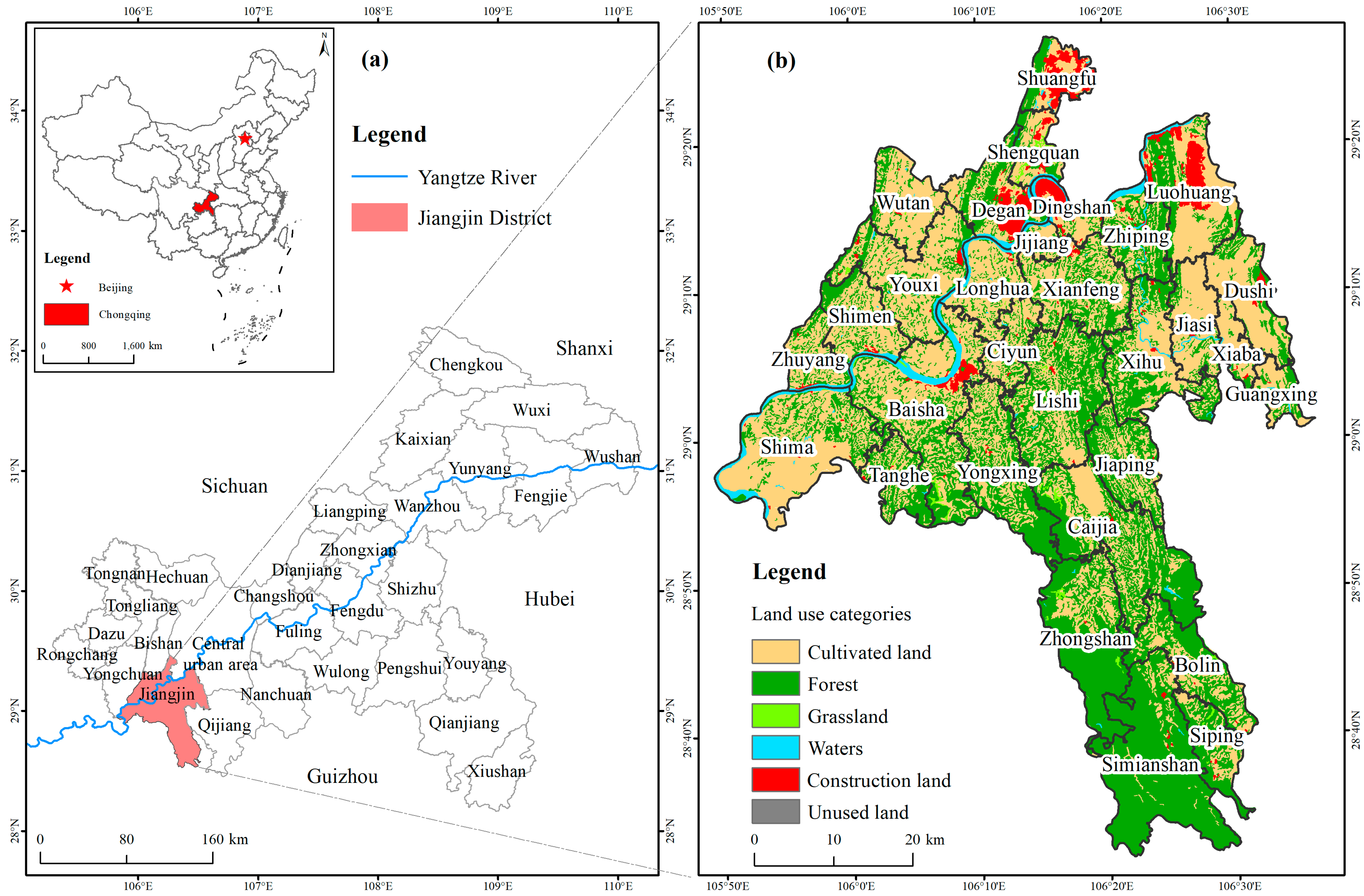
2.1. Study Area

Jiangjin District of Chongqing is located in southwestern Chongqing, adjacent to Guizhou Province to the southeast and Sichuan Province to the west and southwest (Figure 1). The geographical coordinates are between 105°49′–106°38′ E and 28°28′–29°28′ N. Jiangjin District has a total area of 3218 km2, with five subdistricts and 25 towns. The terrain of Jiangjin District descends gradually from north to south to the Yangtze River Valley, with hills and low mountains in the north and middle and mountainous areas in the south. It has a subtropical humid monsoon climate, with a mild climate and abundant precipitation. The main disasters are high temperature, drought, low temperature and rain, hail and so on. At the end of 2019, the forest area in Jiangjin District reached 16.6 × 10⁴ hm2, and the forest coverage rate reached 51.8%. In 2019, the regional GDP of Jiangjin District was 103.67 billion yuan, and the per capita GDP reached 74,452 yuan. At the end of 2019, Jiangjin District had a permanent population of 1.398 million, and the urbanization rate of permanent residents was 69.76%.
As the Chinese government vigorously promotes coordinated regional development, the location advantages and development opportunities of Jiangjin District have become increasingly apparent. The construction of the Chengdu-Chongqing Twin Cities Economic Circle is an important part of the overall national regional development strategy. Jiangjin District is responsible for the construction of the western (Chongqing) Science City Jiangjin area in the construction of the Chengdu-Chongqing Twin Cities Economic Circle. Therefore, it is the vanguard of Sichuan-Chongqing cooperation. In the spatial pattern of the development of the One District and Two Clusters of cities and towns in Chongqing, Jiangjin District is an open new city of science and innovation, a new industrial area, and a cultural and tourist attraction in the main urban area, so it is a leader in the development of the western region of Chongqing. In addition, Jiangjin District is also a pioneering area for the co-urbanization of the main urban area of Chongqing. Obviously, the superposition of many strategies has brought unprecedented development opportunities to Jiangjin District. However, Jiangjin District is located in the upper reaches of the Yangtze River and at the end of the Three Gorges Reservoir, and it is responsible for the construction of the ecological barrier in the Three Gorges Reservoir and the ecological protection of the upper reaches of the Yangtze River. In short, in the context of multiple strategic development opportunities and ecological protection, the question of how to optimize the PLES to provide a great space guarantee both for economic development and to strengthen ecological protection has become a key issue that urgently needs to be resolved in the territorial space planning of Jiangjin District.

2.2. Data Sources and Processing

The data used in this paper mainly includes land use data for 2018 obtained from the Chinese Academy of Sciences Resource and Environmental Science Data Center (https://www.resdc.cn/Default.aspx, accessed on 16 August 2021), with a spatial resolution of 30 m. The data is based on the Landsat 8 remote sensing image of the United States and obtained by manual visual interpretation, and the sampling verification accuracy is above 95%. According to China’s land use classification system based on remote sensing monitoring, the land use classification is divided into six categories: cultivated land, forest land, grassland, water area, construction land and unused land. The data processing steps are as follows: firstly, a 300 × 300 m square geographic grid was constructed, superimposed with the current land use data of the study area, and the area of various land types in each geographic grid was calculated. Secondly, according to the evaluation method of the PLEF of land, the production, living and ecological functions of land use types were assigned, respectively, and the values of PLEF of each geographic grid were calculated based on the ArcGIS10.2 software. Thirdly, we used the coupling coordination degree model to measure the coupling coordination degree among the PLEF and the coupling coordination degree between every two of the PLEF, then, the natural break point classification (Jenks) method was used to divide the coupling coordination degree of the PLEF into three types. Based on the results of the above steps, the PLES was identified. Finally, according to the principle of ecological priority, area dominance and coordinated development, the spatial superposition method to calculate and compare the area size of different functional spaces was used, and the similar types of land were merged to get the optimizing zoning of the PLES.

2.3. Methods

2.3.1. Evaluation of the PLEF of Land

The concept of the PLES is proposed based on the land use functions (LUFs). LUFs refer to the products and services provided for human society by land resources through various utilization methods [46,47]. Its concept can be traced back to the European Union’s research on agricultural multifunction at the end of the 20th century [48,49]. The PLES is the extension of LUFs that the essence of PLES is a functional space divided according to the products and services it provides on the basis of LUFs [21]. Therefore, the logical connection between land use types and land use functions can be established to construct a scientific classification and evaluation system of the PLES [50]. Based on the research results of scholars and guided by the theory of the PLES, this study divided land use functions into production functions, living functions and ecological functions and divided land use types into production land, living land, and ecological land. According to the difference in the strength of the PLEF of land use, this study introduced the concepts of strong production/living/ecological land, semi-production/living/ecological land, and weak production/living/ecological land. Then, values were assigned to strong production/living/ecological land, semi-production/living/ecological land, and weak production/living/ecological land by using the method of grading assignment.
Taking production land as an example, strong production land means that the production function of land is stronger than other functions, so the assigned function score is up to 5 points. Semi-production land means that the production function of land use is roughly equivalent to other functions, so the assigned function score is up to 3 points. A weak production function means that the production function of land use is weaker than other functions, so 1 point is assigned. In addition, nonproduction land refers to land that does not have a production function and is assigned a value of 0. In this paper, strong/semi/weak production land only reflects the dominant function, not the actual performance of the land’s output or the monetary value added per unit of land in terms of productivity. The assignment of living land and ecological land was the same as that of production land (Table 1). First, 300 m × 300 m geographic grids were built based on ArcGIS 10.2 software. Second, the area of each land use type in each geographic grid was counted. Third, the PLEF evaluation method was used to sum the functional scores of production land, living land, and ecological land in each geographic grid. Finally, the spatial distribution map of the production/life/ecological function scores was generated to reveal the distribution pattern of the PLES in the study area. The evaluation method of the PLEF is shown in Formula (1).
W i = i = 1 n S i · V i
In Formula (1), W i refers to the evaluation score of the production/living/ecological function in each geographic grid. i is the land use type. n is the total number of land use types in each geographic grid. S i represents the area of each land use type in each geographic grid, and its unit is hm2.   V i represents the production/living/ecological function value of the unit area of the i-th land use type.

2.3.2. Coupling Coordination Degree Model of the PLEF

The concept of coupling is derived from physics and refers to the phenomenon where two or more systems interact and influence each other. The degree of coupling is used to measure the degree of interaction and mutual influence between multiple systems [51]. However, it cannot reflect the synergic relationship between multiple systems [28]. Therefore, we introduced the coupling coordination index to construct a coupling coordination model. First, by evaluating the production, living and ecological function values of each geographic grid, the coupling coordination model is used to measure the degree of coupling and coordination among the PLEF of each geographic grid to reveal the degree of coordinated development of the PLEF. Second, the coupling coordination degree was divided into a coordination zone, break-in zone and incongruous zone by using the natural breakpoint classification method. Coordination zone refers to the coupling among the PLEF is becoming stronger and developing in an orderly direction, and it is in a period of high-level coupling and coordination. Break-in zone means that the PLEF began to develop in coordination and shows the characteristics of benign coupling and coordination. Incongruous zone refers to the interaction of the PLEF is low, and it is in a state of disorderly development. The specific calculation process is shown in Formulas (2) to (4).
C = 3 { P i · R i · E i ( P i + R i + E i ) 3 } 1 / 3
T = α P i + β R i + γ E i
D = ( C · T ) 1 / 2
In Formula (2), C represents the degree of coupling, with C [ 0 , 1 ] ; the larger the value of C, the stronger the interaction among the PLEF. P i , R i and E i represent the evaluation scores of productive, living and ecological functions, respectively. In Formula (3), T represents the coordination index among the PLEF. α , β and γ respectively refer to the undetermined coefficients of the production function, living function and ecological function. Due to the lack of unified standards and methods for determining the undetermined coefficients, Wang Cheng et al. [22,28] determined the undetermined coefficients based on the opinions of experienced experts, the main functions of the research area and the contribution of PLEF, and their method is certainly reasonable. Therefore, based on the existing research results [22,28] and experts asked for advice, the undetermined coefficients were determined to be α = β = 0.3 and γ = 0.4. In Formula (4), D refers to the degree of coupling and coordination among the PLEF.
Moreover, it is of great significance to further analyze the strengths and weaknesses of the coupling coordination status between every two of the PLEF [28]. Therefore, to explore the coupling coordination status between every two of the PLEF, the coupling coordination degree model is further evolved, as shown in Formulas (5) to (6).
C 1 = 2 { P i · R i ( P i + R i ) 2 } 1 / 2 C 2 = 2 { R i · E i ( R i + E i ) 2 } 1 / 2 C 3 = 2 { P i · E i ( P i + E i ) 2 } 1 / 2
D = ( C · T ) 1 / 2 ,   T 1 = α P i + β R i   or   T 2 = α P i + γ E i   or   T 3 = β R i + γ E i  
Based on the existing research results [19,26], when measuring the degree of coupling and coordination between the production function and living function, α = β = 0.5. When measuring the degree of coupling and coordination between the production function and ecological function, α = 0.45 and γ = 0.55. When measuring the degree of coupling and coordination between the living function and ecological function, β = 0.45 and γ = 0.55.

3. Results

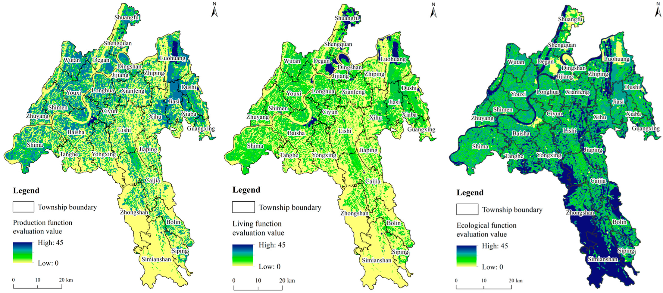
3.1. Evaluation Results and Analysis of the PLEF of Land

The evaluation values of the production function, living function and ecological function of Jiangjin District in 2018 were obtained by using the evaluation system of the PLEF of land (Figure 2). The results showed that the evaluation value of the land production function in Jiangjin District presented a spatial differentiation characteristic that was high in the north and low in the south. The high-scoring areas of the land production function were distributed in Wutan Town, Youxi Town, Shima Town and so on. The production function value of land in the southern region of Jiangjin District, such as Caijia Town, Zhongshan Town and Siping town, was relatively low. Areas with high living function values were mainly distributed in areas with high living function values and were mainly distributed in Shuangfu Street, Degan Street and Luohuang Town. In addition, the spatial distribution of living function values and production function values showed obvious consistency. Moreover, the distribution characteristics of ecological function values and the distribution characteristics of production function values showed significant spatial complementarity. Furthermore, areas with high ecological function values were mainly distributed in the south region of Jiangjin District, such as Bolin Town, Zhongshan Town and Caijia Town, which had low production function and living function scores. At the same time, the areas with low ecological function values were distributed in these areas with strong production function and living function.

3.2. Analysis of the Coupling Coordination Degree of the PLEF

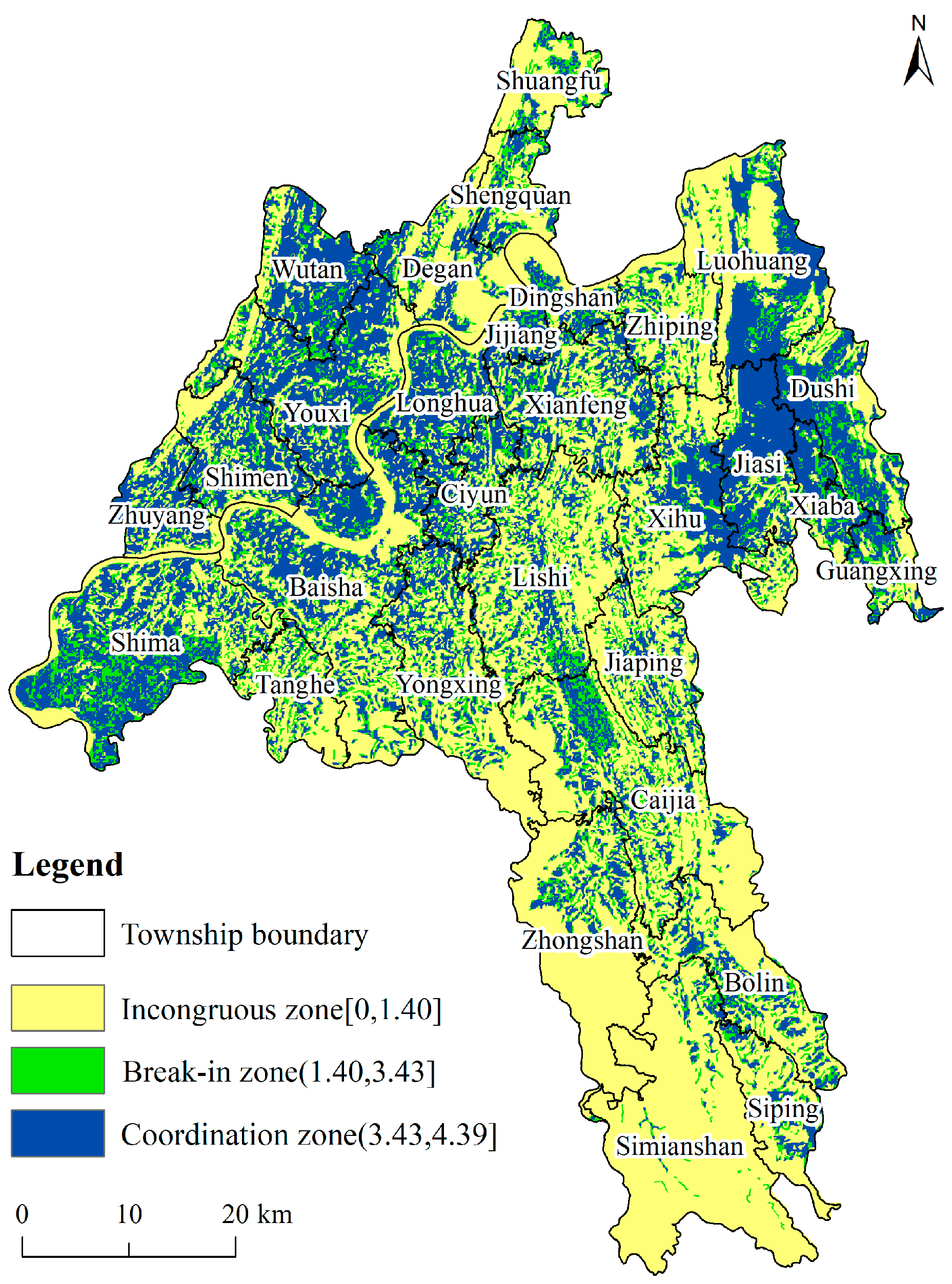
3.2.1. Coupling Coordination Degree among the PLEF

The coupling coordination degree and the spatial distribution map of the PLEF of Jiangjin District in 2018 were obtained through the coupling coordination degree model (Figure 3). The natural breakpoint classification method (Jenks) was used to divide the coupling coordination degree of the PLEF of the study area into three categories which can appropriately group similar values and maximize the difference between each grouping [52] (Table 2).

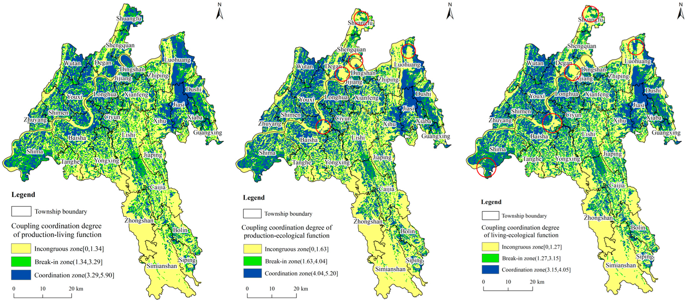
3.2.2. Coupling Coordination Degree between Every Two of the PLEF

The degree of coupling and coordination and the spatial distribution map between every two of the PLEF of Jiangjin District in 2018 were obtained according to Formulas (5) and (6) (Figure 4). Moreover, we divided the degree of coupling and coordination between every two of the PLEF into three categories (incongruous zone, break-in zone and coordination zone) by using the natural breakpoint classification method. However, due to the differences in the degree of coordination between every two of the PLEF, the breakpoint value of the division interval was also different (Table 3, Table 4 and Table 5). In general, the degree of coupling and coordination between every two of the PLEF is generally spatially consistent and high in the north and low in the south.

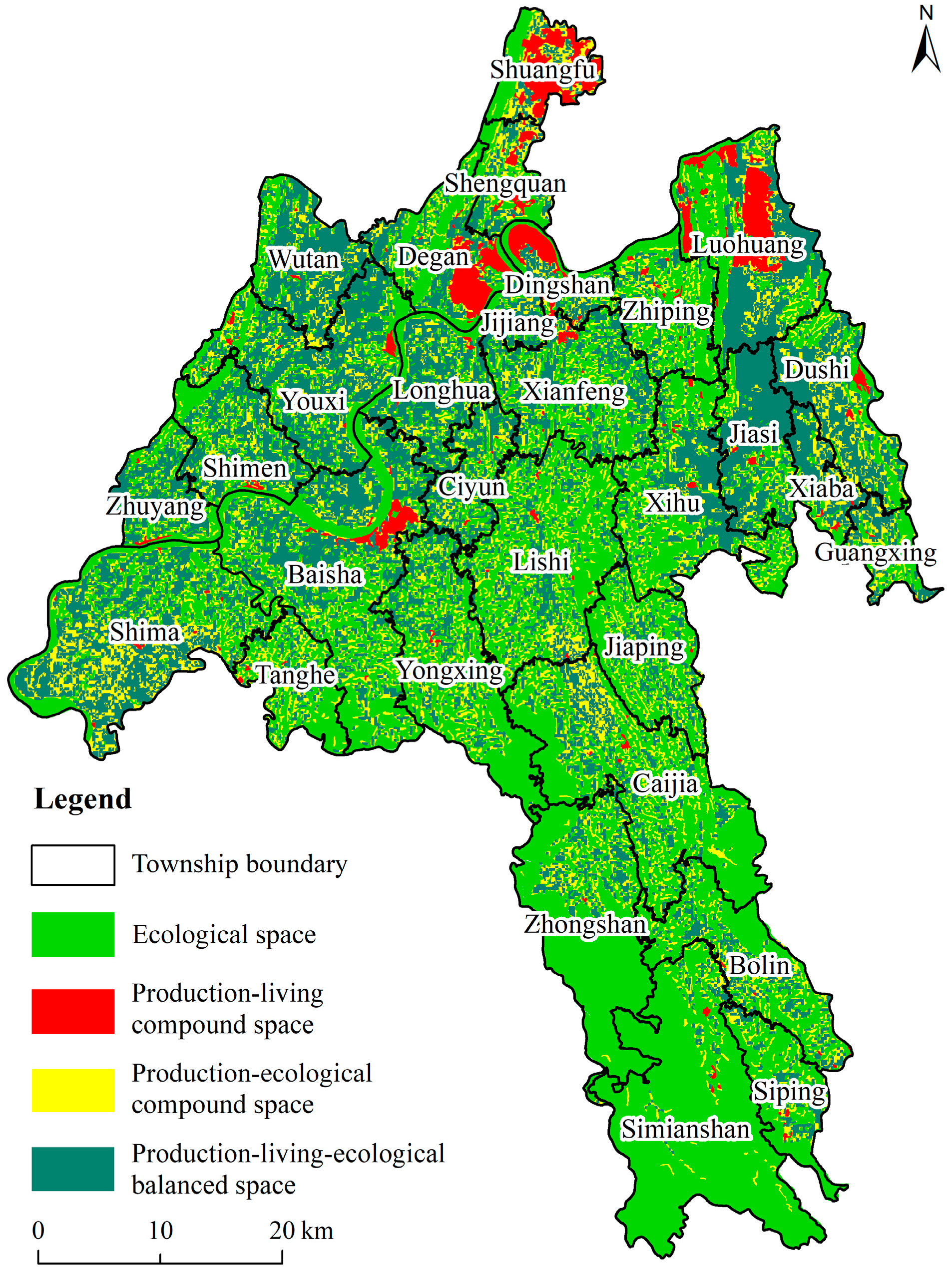
3.3. Identification of the PLES

According to the spatial distribution results of the coupling coordination degree of the PLEF and the coupling coordination degree between every two of the PLEF, we designated the coordinated area of the PLEF as the balanced space of the PLEF. Moreover, we compared the relative advantages of the coupling and coordination degree between every pair of the PLEF within the scope of incongruous zones and break-in zones of the PLEF. Then, the incongruous zone and break-in zone of the PLEF were identified as production-living space (PLS) and production-ecological space (PES). In addition, according to the value of the PLEF, the incongruous zone between every two of the PLEF was divided into single production, living or ecological space. However, the areas of single production space and single living space identified were very small, and the corresponding land use types have both production and living functions; thus, the two single spaces are classified as production-living compound space. Finally, the PLES pattern of Jiangjin District was obtained. The PLEF can be identified as four categories of space—the production-living-ecological balanced space (PLEBS), the production-living space (PLS), the production-ecological space (PES) and the single ecological space (ES) (Figure 5). The proportions of the four categories of space are 32.04%, 3.41%, 15.83% and 48.72%. In general, the territorial space pattern of Jiangjin District presents the characteristics of the PLEBS and the ES as the main body, supplemented by the PLS and the PES.

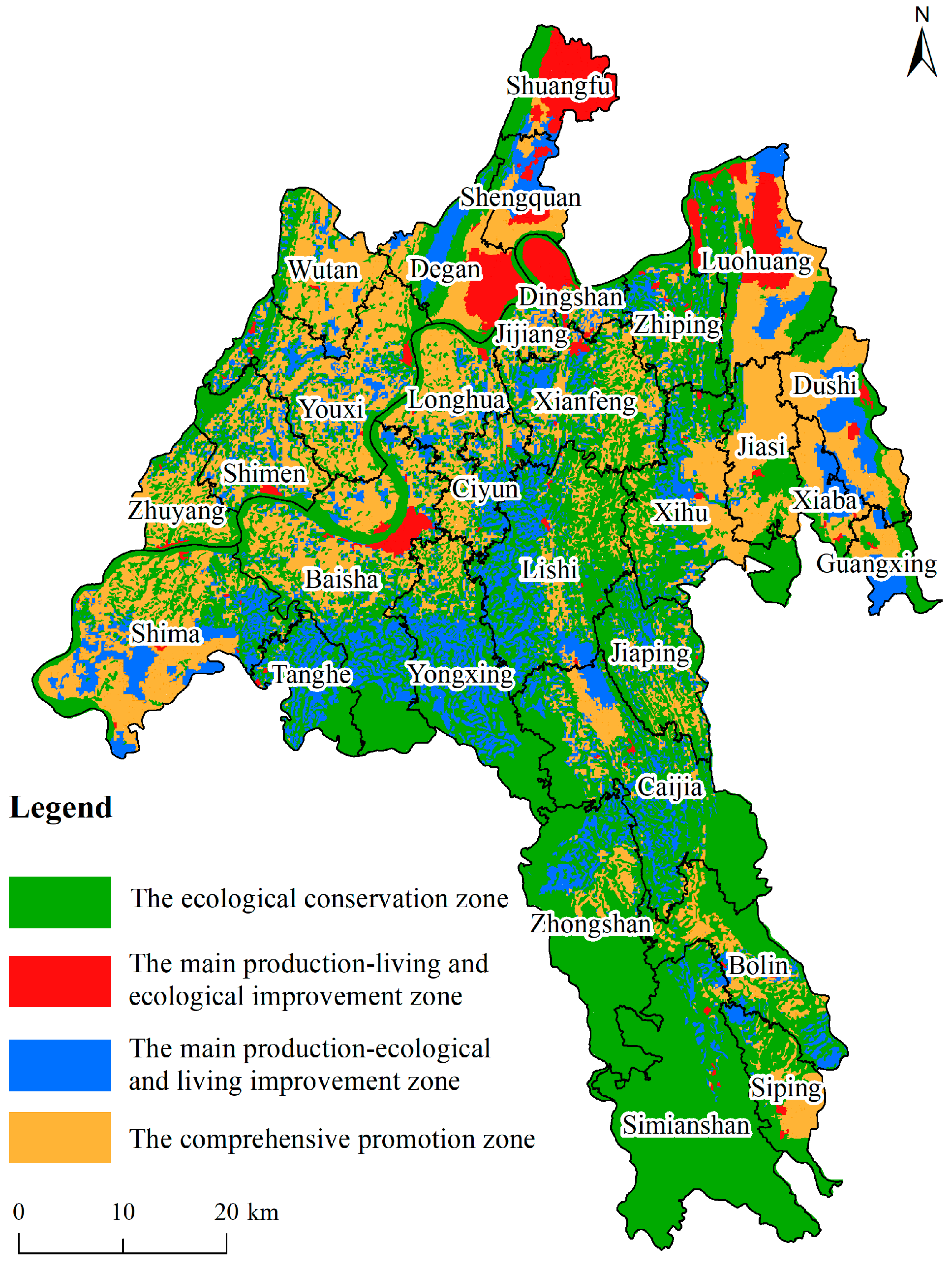
4. Optimized Partition of the PLES

4.1. Principles of Optimizing Zoning

(1)
Principle of ecological priority
Jiangjin District is located in the ecological barrier construction area on the upper reaches of the Yangtze River and at the end of the Three Gorges Reservoir. Furthermore, the ecological environment of Jiangjin District is relatively fragile, so ecological protection is a major task of Jiangjin District. Therefore, when zoning for space optimization, all the grids of the ES are classified as ecological conservation areas to protect the ecological environment of Jiangjin District.
(2)
Principle of area dominance
There are bound to be multiple types of spatial combinations within each township. By comparing the area sizes of different spatial types, the spatial type with the largest area is used to determine the optimal spatial division type of each township.
(3)
Principle of coordinated development
The essence of optimizing the territorial spatial pattern is to enhance the capacity of regional sustainable development through the optimization of the structure and distribution of the PLES and to provide a space guarantee for social development, livable life and good ecology. Due to the differences in the strengths and weaknesses of the PLEF in different spatial units, the weak functions should be promoted in the process of space optimization to achieve the goal of the coordinated development of the PLES.

4.2. Scheme of Optimizing Zoning

The geographic grid could describe in detail the spatial heterogeneity of the PLEF, but there was also a problem in that it divided administrative units, which was not conducive to space governance [53,54]. Therefore, to ensure that the optimization results of the PLES have good practical significance, we used townships as the basic unit to optimize the space division and proposed suggestions for different development directions. First, based on the recognition result of the combination categories of PLES, we used the space superposition method to compare the areas of different space categories. Then, the adjacent or similar categories were merged according to the principle of ecological priority, area dominance and coordinated development (Table 6). Finally, the optimal zoning scheme of PLES is proposed, which takes the township as the basic unit (Figure 6).
(1) Comprehensive promotion zone. This area has ecological, living and ecological functions, and it mainly distributed in the east of the northwest area of Jiangjin District. The land use types in this area are dominated by paddy fields and dry land, with abundant cultivated land resources but a relative lack of infrastructure. Therefore, this area should make full use of regional resource endowments, vigorously develop high-efficiency agriculture such as flowers, seedlings, and high-quality fruits, establish small and medium-sized entrepreneurship bases, develop supporting industries and leisure tourism, promote the integrated development of agriculture and tourism, and enhance the production function. Second, it should strengthen the harmless treatment of domestic sewage and garbage and the control of agricultural nonpoint source pollution and soil pollution. In addition, protection measures of the ecological environment should be taken to improve the ecological function. Moreover, the construction of public infrastructure services should be strengthened, especially rural roads, medical health and education, to continuously improve the living environment and improve the quality of life.
(2) Ecological conservation zone. This area takes the ecological function as the main function, while living function and production function as the secondary function. The land use types are mainly woodland, grassland and waters. This area covers the Simian mountainous areas in the south of Jiangjin District, the Linfeng mountainous areas in the north of Jiangjin District, the Longmen mountainous areas in the east of Jiangjin District and the waters of the Yangtze River across the north region of Jiangjin District. Undoubtedly, this area bears the responsibility of ecological protection, so it should exploit the advantages of the ecological function and reasonably and appropriately develop ecotourism and eco-industry by protecting the ecological environment. In the southern region, Zhongshan Town, Bolin Town, Caijia Town and other places could moderately develop ecological leisure vacation tourism, seize the advantage of selenium-rich, plant ecological selenium-rich agricultural and sideline products, vigorously cultivate new green kinetic energy and transform the advantages of ecological environment into advantages of green development. The northern region of Jiangjin District should strengthen the comprehensive management of industrial and agricultural pollution prevention, shoreline protection and restoration and combat illegal fishing to strictly protect the ecological environment and biodiversity of the Yangtze River.
(3) The main production-living and ecological improvement zone. This area is dominated by production and living functions, with weak ecological functions. This area is the core growth pole of the economic development of Jiangjin District. The land use intensity is high, and the economy is relatively developed. However, there were some problems in this area, such as its dense population, production and life pollution, which pose a great threat to ecological security. Moreover, the vegetation coverage rate is low, and the ecological function is weak in this area. Therefore, the area should continue to improve public infrastructure, such as transportation and logistics, strengthen the management of industry and improve the quality of the living environment. By strengthening production and the living function, high-tech industries should be developed, ecological environment management should be strengthened, ecological land areas should be increased, the ecological function should be improved and the coordinated development of the PLEF should be promoted.
(4) The main production-ecological and living improvement zone. This area is characterized by strong production and ecological functions and a weak living function. The region is flat and rich in arable land resources. However, the infrastructure and public services are backward, and the living environment needs to be improved. By protecting arable land resources, this area should strengthen the construction of infrastructure, such as transportation, culture and sports centers, to improve life service functions. In addition, this area should strengthen the treatment of rural domestic garbage, livestock and poultry manure, improve the quality of human settlements and continuously improve regional life features.

5. Discussion

5.1. Advantages of the Method and Comparison of Research Results

Compared with existing research about PLES [55,56,57], this study conducted research by constructing a fine-grained geographic grid and introducing the coupling coordination degree model of the land the PLEF and combined the coupling and coordination degree of the PLEF between every two of the PLEF for analysis. This overcomes the limitation of the overall coupling and coordination between the administrative unit scale and the single measurement of the PLEF [22]. The research results could provide a valuable reference for clarifying the direction of territorial spatial optimization and enriching the theoretical meaning of the PLES. Moreover, compared with other land use optimization methods [35,36,37,38], the evaluation method of PLEF of land was constructed from the perspective of PLES and LUFs in this paper, and the coupling coordination degree model was used to explore the interaction among production, living and ecological functions in the land system. On this basis, we further proposed a space optimization scheme. It has reference value for promoting the application of PLES in the optimization of land use. In addition, the subjective grading method adopted in this article has already referred to the opinions of experienced experts in this field, which to a certain extent can reflect the differences in the strengths and weaknesses of the PLEF of land in the study area.
In addition, it’s worth discussing that the research results show that the territorial space of Jiangjin District can be identified as four categories of space: the PLEBS, the PLS, the PES and the ES. Compared with previous studies on the identification of the PLES [21,22], the research results lacked a single production space and a single living space. The reason is that people’s production and life are inseparable, and it is difficult to clearly delineate the boundary between the two categories of a single space in terms of spatial expression. In the identification results, the single production space and the living space are relatively small, so they are merged into the PLS.
Moreover, in 2014, the National Development and Reform Commission of China issued “the Thirteenth Five-Year City and County Economic and Social Development Planning Reform and Innovation Guidance Opinions”, which required that the proportion of ecological space in key ecological function areas, cities and counties be higher than 50%. In the research results of this study, the ES only accounts for 48.72%. The reason for this is that the PLEBS and the PES both had ecological functions. Therefore, the identification result of this study was in line with the policy requirements, so the research results have reference value.

5.2. Implications for Spatial Management

In recent years, territorial space governance has gradually become the focus of research on human-environment relationship coordination and sustainable development [58]. The upper reaches of the Yangtze River is an important ecological barrier in the western region of China and the most critical area for the ecological environment protection in the Yangtze River Basin. With the rapid development of industrialization and urbanization, the interaction between human and environment in the upper reaches of the Yangtze River has been strengthened, which has produced a series of ecological problems such as water pollution and ecological destruction [12]. Therefore, it is urgent to strengthen regional territorial space governance and strengthen the construction of ecological barrier in the upper reaches of the Yangtze River. Combined with the results of this study, we suggest that the spatial management strategy in the ecological barrier area of the upper Yangtze River should focus on the following two aspects:
(1) At the macro level, the ecological barrier area in the upper reaches of the Yangtze River should adhere to the principle of ecological priority and green development, a more coordinated planning for space utilization and protection should be formulated. Moreover, the main function zoning and the three zones and three lines should be implemented. In addition, the use of PLEL should be strictly controlled to promote the coordinated development of PLES.
(2) At the micro level, more reasonable optimization measures should be taken in view of the main problems facing the management of PLES. In the territorial space with ecological function as the main body, ecological protection and restoration should be further strengthened, and ecological tourism and ecological industry could be reasonably developed under the premise of ecological protection. In addition, on the basis of strengthening the dominant functions, the territorial space with complex functions will enhance the weak functions and promote the coordinated development of the three functions. For example, in the production-living complex space, public service facilities should be improved to strengthen the leading function of production-living. At the same time, the control of production and living pollution in both urban and rural areas should be strengthened. Moreover, it can increase the ecological land area to improve the ecological function.

5.3. Research Limitations

This study also has some limitations. On the one hand, this paper divided the land use functions into production, living and ecological functions, and used the subjective assigning method to assign and grade each function to distinguish the difference between strong and weak functions. However, compared with the current quantitative analysis model and method used by most scholars to study land use optimization, the method adopted in this article has strong subjectivity and cannot reflect the actual situation of the study area more objectively. Therefore, in order to improve the accuracy of land function identification, it is necessary to build a quantitative method or model to distinguish the strength difference of certain land functions in the future. On the other hand, this article only constructed an evaluation system of the PLES from the multifunctional perspective of land use. However, we treated other factors as attributes implicit in land use, such as socioeconomic development and terrain slope, which may lead to certain limitations in the recognition results. Thus, to better adapt to the new needs of land space planning and regional space governance in the future, it is necessary to comprehensively consider the regional natural geographical environment, resource endowments, social and economic development and regional policies and other factors to construct a more comprehensive evaluation system of the PLEF and further explore the formation mechanism of the regional the PLES.

6. Conclusions

(1) The land production function in Jiangjin District presents spatial differentiation characteristics that are high in the north and low in the south. The spatial distribution of the living function and production function showed obvious consistency. In addition, the ecological function of Jiangjin District was relatively dominant, and its spatial distribution showed significant spatial complementarity with the production function and living function distribution characteristics. Areas with high ecological functions are mainly distributed in the waters of the Yangtze River and mountainous areas. In general, the area dominated by living function and production function in the study area showed obvious spatial consistency, and the spatial distribution characteristics of ecological function dominance and production function dominance showed significant spatial complementarity. The spatial distribution pattern of the PLES conforms to the basic characteristics of the ecological barrier zone in the upper reaches of the Yangtze River and the overall requirements of achieving great protection and not engaging in large-scale development.
(2) The degree of coupling and coordination of the PLEF of Jiangjin District in 2018 can be divided into incongruous zone, break-in zone, and coordination zone. The coordination zone of the PLEF is mainly distributed in the northern part of Jiangjin District. The break-in zone of the PLEF is distributed in points between the imbalanced area and the coordination area, with a wide distribution range. The incongruous zone of the PLEF is distributed throughout Jiangjin District and is especially concentrated in the southern region. Moreover, the degree of coupling and coordination between every two of the PLEF generally shows spatial consistency—high in the north and low in the south.
(3) Four space categories can be identified in the study area: the PLEBS, the PLS, the PES, and the ES. The proportions of the four categories of space are 32.04%, 3.41%, 15.83%, and 48.72%. In general, the territorial spatial pattern of Jiangjin District presents the characteristics of the PLEBS and the ES as the main body, supplemented by the PLS and the PES.
(4) The optimized partitions of the PLES in Jiangjin District can be divided into four types: the ecological conservation area, the main production-living and ecological improvement zone, the main production-ecological and living improvement zone and comprehensive promotion zone. The space dominated by production and living functions should enhance the ecological function to realize the coordinated development of the PLES, while the ecological function-oriented space should take the protection of the ecological environment as the primary goal and exploit the advantages of the ecological function to develop ecotourism and ecological industries by protecting the ecological environment.

Author Contributions

The co-authors together contributed to the completion of this article. Specifically, it follows their individual contribution: conceptualization, H.C. and Q.Y.; validation, Q.Y. and K.S.; data curation, H.C., H.Z. and D.L.; formal analysis, Q.Y. and D.L.; methodology, H.C., K.S. and L.Z.; supervision, project administration, Q.Y.; writing—original draft, H.C.; writing—review and editing, H.C., Q.Y. and H.X.; visualization, H.C. All authors have read and agreed to the published version of the manuscript.

Funding

This research was funded by Chongqing Social Science Planning Project, grant number 2020YBZX15.

Institutional Review Board Statement

Not applicable.

Informed Consent Statement

Not applicable.

Data Availability Statement

The data presented in this study are available on request from the author.

Acknowledgments

Thank you to everyone who contributed to this study.

Conflicts of Interest

The authors declare no conflict of interest.

References

  1. Wang, D.; Jiang, D.; Fu, J.; Lin, G.; Zhang, J. Comprehensive assessment of production-living-ecological space based on the coupling coordination degree model. Sustainability 2020, 12, 2009. [Google Scholar] [CrossRef] [Green Version]
  2. Lin, G.; Fu, J.; Jiang, D. Production-living-ecological conflict identification using a multiscale integration model based on spatial suitability analysis and sustainable development evaluation: A case study of Ningbo, China. Land 2021, 10, 383. [Google Scholar] [CrossRef]
  3. Lin, G.; Jiang, D.; Fu, J.; Cao, C.; Zhang, D. Spatial conflict of production-living-ecological space and sustainable-development scenario simulation in Yangtze River Delta Agglomerations. Sustainability 2020, 12, 2175. [Google Scholar] [CrossRef] [Green Version]
  4. Yang, Q.; Luo, K.; Lao, X. Evolution and enlightenment of foreign spatial planning: Exploration from the perspective of geography. Acta Geogr. Sin. 2020, 75, 1223–1236. (In Chinese) [Google Scholar]
  5. Liu, Y.; Fang, F.; Li, Y. Key issues of land use in China and implications for policy making. Land Use Policy 2014, 40, 6–12. [Google Scholar] [CrossRef]
  6. Lu, D.; Wang, Y.; Yang, Q.; Su, K.; Zhang, H.; Li, Y. Modeling spatiotemporal population changes by integrating DMSP-OLS and NPP-VIIRS nighttime light data in Chongqing, China. Remote Sens. 2021, 13, 284. [Google Scholar] [CrossRef]
  7. Zou, L.; Liu, Y.; Wang, J.; Yang, Y. An analysis of land use conflict potentials based on ecological-production-living function in the southeast coastal area of China. Ecol. Indic. 2021, 122, 107297. [Google Scholar] [CrossRef]
  8. Liu, Y.; Li, J.; Yang, Y. Strategic adjustment of land use policy under the economic transformation. Land Use Policy 2018, 74, 5–14. [Google Scholar] [CrossRef]
  9. Su, K.; Hu, B.; Shi, K.; Zhang, Z.; Yang, Q. The structural and functional evolution of rural homesteads in mountainous areas: A case study of Sujiaying village in Yunnan province, China. Land Use Policy 2019, 88, 104100. [Google Scholar] [CrossRef]
  10. Li, J.; Sun, W.; Yu, J. Change and regional differences of production-living-ecological space in the Yellow River Basin: Based on comparative analysis of resource-based and non-resource-based cities. Res. Sci. 2020, 42, 2285–2299. (In Chinese) [Google Scholar]
  11. Duan, Y.; Wang, H.; Huang, A.; Xu, Y.; Lu, L.; Ji, Z. Identification and spatial-temporal evolution of rural “production-living-ecological” space from the perspective of villagers’ behavior-A case study of Ertai Town, Zhangjiakou City. Land Use Policy 2021, 106, 105457. [Google Scholar] [CrossRef]
  12. Zhang, H.; Yang, Q.; Zhang, Z.; Lu, D.; Zhang, H. Spatiotemporal changes of ecosystem service value determined by national land space pattern change: A case study of Fengdu County in The Three Gorges Reservoir Area, China. Int. J. Environ. Res. Public Health 2021, 18, 5007. [Google Scholar] [CrossRef]
  13. Cao, S.; Hu, D.; Hu, Z.; Zhao, W.; Chen, S.; Yu, C. Comparison of spatial structures of urban agglomerations between the Beijing-Tianjin-Hebei and Boswash based on the subpixel-level impervious surface coverage product. J. Geogr. Sci. 2018, 28, 306–322. [Google Scholar] [CrossRef] [Green Version]
  14. Sun, X.; Yu, C.; Wang, J.; Wang, M. The intensity analysis of production living ecological land in Shandong Province, China. Sustainability 2020, 12, 8326. [Google Scholar] [CrossRef]
  15. Wei, C.; Lin, Q.; Yu, L.; Zhang, H.; Ye, S.; Zhang, D. Research on sustainable land use based on production-living-ecological function: A case study of Hubei Province, China. Sustainability 2021, 13, 996. [Google Scholar] [CrossRef]
  16. Shi, Z.; Deng, W.; Zhang, S. Spatio-temporal pattern changes of land space in Hengduan Mountains during 1990–2015. J. Geogr. Sci. 2018, 28, 529–542. [Google Scholar] [CrossRef] [Green Version]
  17. Deng, W.; Zhang, J.; Shi, Z.; Wan, J.; Meng, B. Interpretation of mountain territory space and its optimized conceptual model and theoretical framework. Mt. Res. 2017, 35, 121–128. (In Chinese) [Google Scholar]
  18. Tang, C.; He, Y.; Zhou, G.; Zeng, S.; Xiao, L. Optimizing the spatial organization of rural settlements based on life quality. J. Geogr. Sci. 2018, 28, 685–704. [Google Scholar] [CrossRef] [Green Version]
  19. Huang, A.; Xu, Y.; Lu, L.; Liu, C.; Zhang, Y.; Hao, J.; Wang, H. Research progress of the identification and optimization of production-living-ecological spaces. Prog. Geogr. 2020, 39, 503–518. (In Chinese) [Google Scholar] [CrossRef]
  20. Fang, C.L. Scientific cognition and technical paths of urban multiple planning integration in China. China Land Sci. 2017, 31, 28–36. (In Chinese) [Google Scholar]
  21. Ji, Z.; Liu, C.; Xu, Y.; Huang, A.; Lu, L.; Duan, Y. Identification and optimal regulation of the production-living-ecological space based on quantitative land use functions. Trans. Chin. Soc. Agric. Eng. 2020, 36, 222–231, 315. (In Chinese) [Google Scholar]
  22. Sui, H.; Song, G.; Zhang, H. Identification of production-living-ecological space at Keshan County level in main grain producing areas in northern Songnen Plain, China. Trans. Chin. Soc. Agric. Eng. 2020, 36, 264–271, 323. (In Chinese) [Google Scholar]
  23. Li, G.; Fang, C. Quantitative function identification and analysis of urban ecological-production-living spaces. Acta Geogr. Sin. 2016, 71, 49–65. (In Chinese) [Google Scholar]
  24. Tu, S.; Long, H.; Zhang, Y.; Ge, D.; Qu, Y. Rural restructuring at village level under rapid urbanization in metropolitan suburbs of China and its implications for innovations in land use policy. Habitat Int. 2018, 77, 143–152. [Google Scholar] [CrossRef]
  25. Tu, S.; Long, H. Rural restructuring in China: Theory, approaches and research prospect. J. Geogr. Sci. 2017, 27, 1169–1184. [Google Scholar] [CrossRef]
  26. Yu, Z.S.; Chen, Y.Q.; Li, X.J.; Sun, D.Q. Spatial evolution process, motivation and restructuring of “production-living-ecology” in industrial town: A case study on Qugou Town in Henan Province. Sci. Geogr. Sin. 2020, 40, 646–656. (In Chinese) [Google Scholar]
  27. Tao, Y.; Wang, Q. Quantitative recognition and characteristic analysis of production-living-ecological space evolution for five resource-based cities: Zululand, Xuzhou, Lota, Surf Coast and Ruhr. Remote Sens. 2021, 13, 1563. [Google Scholar] [CrossRef]
  28. Cheng, W.; Ning, T. Spatio-temporal characteristics and evolution of rural productionliving-ecological space function coupling coordination in Chongqing Municipality. Geogr. Res. 2018, 37, 1100–1114. (In Chinese) [Google Scholar]
  29. Huang, J.C.; Lin, H.X.; Qi, X.X. A literature review on optimization of spatial development pattern based on ecological-production-living space. Prog. Geogr. 2017, 36, 378–391. (In Chinese) [Google Scholar]
  30. Liao, G.; He, P.; Gao, X.; Deng, L.; Zhang, H.; Feng, N.; Zhou, W.; Deng, O. The production-living-ecological land classification system and its characteristics in the Hilly Area of Sichuan Province, Southwest China based on identification of the main functions. Sustainability 2019, 11, 1600. [Google Scholar] [CrossRef] [Green Version]
  31. Wang, X.; Wang, Z.Q.; Jin, G.; Yang, J. Transactions of the Chinese Society of Agricultural Engineering. Trans. Chin. Soc. Agric. Eng. 2016, 32, 240–248. (In Chinese) [Google Scholar]
  32. Paracchini, M.L.; Pacini, C.; Jones, M.L.M.; Perez-Soba, M. An aggregation framework to link indicators associated with multifunctional land use to the stakeholder evaluation of policy options. Ecol. Indic. 2011, 11, 71–80. [Google Scholar] [CrossRef]
  33. Porta, J.; Parapar, J.; Doallo, R.; Rivera, F.F.; Sante, I.; Crecente, R. High performance genetic algorithm for land use planning. Comput. Environ. Urban Syst. 2013, 37, 45–58. [Google Scholar] [CrossRef]
  34. Cao, K.; Huang, B.; Wang, S.; Lin, H. Sustainable land use optimization using Boundary-based Fast Genetic Algorithm. Comput. Environ. Urban Syst. 2012, 36, 257–269. [Google Scholar] [CrossRef]
  35. Yuan, M.; Liu, Y.; He, J.; Liu, D. Regional land-use allocation using a coupled MAS and GA model: From local simulation to global optimization, a case study in Caidian District, Wuhan, China. Cartogr. Geogr. Inf. Sci. 2014, 41, 363–378. [Google Scholar] [CrossRef]
  36. Hagenauer, J.; Helbich, M. Mining urban land-use patterns from volunteered geographic information by means of genetic algorithms and artificial neural networks. Int. J. Geogr. Inf. Sci. 2012, 26, 963–982. [Google Scholar] [CrossRef]
  37. Zheng, W.; Ke, X.; Xiao, B.; Zhou, T. Optimising land use allocation to balance ecosystem services and economic benefits—A case study in Wuhan, China. J. Environ. Manag. 2019, 248, 109306. [Google Scholar] [CrossRef] [PubMed]
  38. Zhang, L.; Xie, L.; Xiao, Y. Maximising the bene fi ts of regulatory ecosystem services via spatial optimisation. J. Clean. Prod. 2021, 291, 125272. [Google Scholar] [CrossRef]
  39. Elliot, T.; Bertrand, A.; Almenar, J.B.; Petucco, C.; Proenca, V.; Rugani, B. Spatial optimisation of urban ecosystem services through integrated participatory and multi-objective integer linear programming. Ecol. Model. 2019, 409, 108774. [Google Scholar] [CrossRef]
  40. Herzig, A.; Ausseil, A.; Dymond, J.R. Spatial optimisation of ecosystem services. In Ecosystem Services in New Zealand—Conditions and Trends; Landcare Research: Lincoln, New Zealand, 2013. [Google Scholar]
  41. Zhang, X.; Xu, Z. Functional coupling degree and human activity intensity of production-living-ecological space in underdeveloped regions in China: Case study of Guizhou Province. Land 2021, 10, 56. [Google Scholar] [CrossRef]
  42. Yang, H.; Lu, X. Study on village type identification based on spatial evolution and simulation of “production-living-ecological space”: A case study of Changning City in Hunan Province. China Land Sci. 2020, 34, 18–27. (In Chinese) [Google Scholar]
  43. Cui, J.; Gu, J.; Sun, J.; Luo, J. The spatial pattern and evolution characteristics of the production, living and ecological space in Hubei Provence. China Land Sci. 2018, 32, 67–73. (In Chinese) [Google Scholar]
  44. Xiaoyu, C.; Qingyuan, Y.; Guohua, B. Temporal and spatial difference of land resource carrying capacity of Jangjin District in Chongqing. Res. Environ. Yangtze Basin 2019, 28, 2319–2330. (In Chinese) [Google Scholar]
  45. Wang, C.; Ren, M.; Li, H.; Zhu, Y. Understanding the rural production space system: A case study in Jiangjin, China. Sustainability 2019, 11, 2811. [Google Scholar] [CrossRef] [Green Version]
  46. Verburg, P.H.; Van De Steeg, J.; Veldkamp, A.; Willemen, L. From land cover change to land function dynamics: A major challenge to improve land characterization. J. Environ. Manag. 2009, 90, 1327–1335. [Google Scholar] [CrossRef] [PubMed]
  47. Zhang, Y.; Long, H.; Tu, S.; Ge, D.; Ma, L.; Wang, L. Spatial identification of land use functions and their tradeoffs/synergies in China: Implications for sustainable land management. Ecol. Indic. 2019, 107, 105550. [Google Scholar] [CrossRef]
  48. Huang, J.; Tichit, M.; Poulot, M.; Darly, S.; Li, S.; Petit, C.; Aubry, C. Comparative review of multifunctionality and ecosystem services in sustainable agriculture. J. Environ. Manag. 2015, 149, 138–147. [Google Scholar] [CrossRef]
  49. Brunstad, R.J.; Gaasland, I.; Vardal, E. Multifunctionality of agriculture: An inquiry into the complementarity between landscape preservation and food security. Eur. Rev. Agric. Econ. 2005, 32, 469–488. [Google Scholar] [CrossRef]
  50. Liu, J.; Liu, Y.; Li, Y. Classification evaluation and spatial-temporal analysis of “production-living-ecological” spaces in China. Acta Geogr. Sin. 2017, 72, 1290–1304. (In Chinese) [Google Scholar]
  51. Ma, L.; Jin, F.; Song, Z.; Liu, Y. Spatial coupling analysis of regional economic development and environmental, pollution in China. J. Geogr. Sci. 2013, 23, 525–537. [Google Scholar] [CrossRef]
  52. Zhao, Z.; Zhao, L.; Wang, Y.; Yuan, T. Analysis of water resources utilization efficiency and water saving potential in Xiong’an New Area under different scenarios. J. Nat. Res. 2019, 34, 2629–2642. (In Chinese) [Google Scholar]
  53. Tan, M.; Li, X.; Li, S.; Xin, L.; Wang, X.; Li, Q.; Li, W.; Li, Y.; Xiang, W. Modeling population density based on nighttime light images and land use data in China. Appl. Geogr. 2018, 90, 239–247. [Google Scholar] [CrossRef]
  54. Wang, J.; Sun, J. Some in-depth thoughts on resources and environmental comprehensive scientific expedition using gridding approach in China. J. Geo-Inf. Sci. 2015, 17, 758–764. (In Chinese) [Google Scholar]
  55. Jin, X.X.; Lu, Y.Q.; Lin, J.H.; Qi, X.H.; Hu, G.J.; Li, X. Research on the evolution of spatiotemporal patterns of production-livingecological space in an urban agglomeration in the Fujian Delta region, China. Acta Ecol. Sin. 2018, 38, 4286–4295. (In Chinese) [Google Scholar]
  56. Zhu, Y.Y.; Yu, B.; Zeng, J.X.; Han, Y. Spatial optimization from three spaces of production, living and ecology in national restricted zones—A case study of Wufeng County in Hubei Province. Econ. Geogr. 2015, 35, 26–32. (In Chinese) [Google Scholar]
  57. Cui, S.Q.; Zhu, P.J.; Zhou, G.H.; Zhang, H.H.; Deng, X.Z. Urban spatial function change and regulation path from the perspective of“production-living-ecological”: Taking Changsha City as an example. Res. Environ. Yangtze Basin 2020, 29, 1733–1745. (In Chinese) [Google Scholar]
  58. Gao, L.; Bryan, B.A. Finding pathways to national-scale land-sector sustainability. Nature 2017, 544, 217–222. [Google Scholar] [CrossRef]
Figure 1. The study area: (a) the location of Jiangjin District in Chongqing; (b) land use status of Jiangjin District in 2018. Note: Based on the standard map (scale 1:48 million) with the approval number of GS (2019) 1823 on the standard map service website, the base map has not been modified.
Land 10 00863 g001
Figure 2. Evaluation value of the PLEF of Jiangjin District in 2018.
Land 10 00863 g002
Figure 3. Spatial distribution of the coupling coordination degree of the PLEF of Jiangjin District in 2018.
Land 10 00863 g003
Figure 4. Spatial distribution of the coupling coordination degree between the production-living, the production-ecological and the living-ecological functions of Jiangjin District in 2018.
Land 10 00863 g004
Figure 5. Identification results of the PLES of Jiangjin District in 2018.
Land 10 00863 g005
Figure 6. Optimized zoning map of the PLES of Jiangjin District in 2018.
Land 10 00863 g006
Table 1. Classification and function assignment of the PLEL of Jiangjin District in 2018.
Primary CategoriesSecondary Categories and Function ScoreTertiary Categories
Production landStrong production land (5)Industrial and mining construction land
Semi-production land (3)Paddy field, dry land, urban land, rural settlement
Weak production land (1)Forest, grassland, river and canals, lake, reservoir pond
Living landStrong living land (5)Urban land, rural settlement
Semi-living land (3)Industrial and mining construction land
Weak living land (1)Paddy field, dry land, river and canals, lake, reservoir pond
Ecological landStrong ecological land (5)Forest, grassland, river and canals, lake, shoaly land, wetland
Semi-ecological land (3)Paddy field, dry land
Weak ecological land (1)Lake, reservoir pond
Table 2. Classification and distribution of the coupling coordination degree of the PLEF.
Function Evaluation ValueCategoriesDistribution
[0, 1.40]Incongruous zoneTownships such as Zhongshan Town, Berlin Town, Degan Street, etc.
(1.40, 3.34]Break-in zoneDistributed in points between the ncongruous zone and the coordination zone, with a wide range of distribution;
(3.34, 4.39]Coordination zoneJiasi Town, Dushi Town, Wutan Town, Youxi Town and other places
Table 3. Classification and distribution of the coupling coordination degree of the production-living function (PLF) of Jiangjin District in 2018.
Function Evaluation ValueCategoriesDistribution
[0, 1.34]Incongruous zoneMainly distributed in Zhongshan Town and Berlin Town in the southern area.
(1.34, 3.29]Break-in zoneScattered between the imbalance zone and the coordination zone in the entire study area.
(3.29, 5.90]Coordination zoneIt is mainly distributed in Jiasi Town and Luohuang Town in the east and Wutan Town and Youxi Town in the midwest.
Table 4. Classification and distribution of the coupling coordination degree of the production-ecological function (PEF) of Jiangjin District in 2018.
Function Evaluation ValueCategoriesDistribution
[0, 1.63]Incongruous zoneIt is mainly distributed in Shuangfu Street and Degan Street in the north; Luohuang Town and Zhiping Street in the east; and Zhongshan Town and Berlin Town in the south.
(1.63, 4.04]Break-in zoneScattered in the whole area of Jiangjin District
(4.04, 5.20]Coordination zoneThey are mainly distributed in Jiasi Town, Dushi Town, and Xiaba Town in the east and Wutan Town, Youxi Town, Shimen Town, and Shima Town in the west and other places.
Table 5. Classification and distribution of the coupling coordination degree of the living-ecological function (LEF) of Jiangjin District in 2018.
Function Evaluation ValueCategoriesDistribution
[0, 1.27]Incongruous zoneIt is distributed throughout the whole area, mainly in Shuangfu Street and Degan Street in the north; Luohuang Town in the east and Zhongshan Town and Berlin Town in the south.
(1.27, 3.15]Break-in zoneThe distribution area is small, scattered in the whole area of Jiangjin District.
(3.15, 4.05]Coordination zoneIt is mainly distributed in Jiasi Town, Dushi Town, and Xiaba Town in the east and Wutan Town, Baisha Town, Youxi Town, Shimen Town, and Shima Town and other places in the west.
Table 6. Optimized zoning of the PLES in Jiangjin District.
Space CategoriesScheme of Optimizing ZoningGoal-Oriented
Ecological space (ES)The ecological conservation zoneEcological protection
Production-living space (PLS)The main production-living and ecological improvement zoneSpace coordinated development
Production-ecological space (PES)The main production-ecological and living improvement zoneSpace coordinated development
production-living-ecological balanced space (PLEBS)The comprehensive promotion zoneSpace coordinated development
Publisher’s Note: MDPI stays neutral with regard to jurisdictional claims in published maps and institutional affiliations.

