
Assessment of Fire Effects on Surface Runoff Erosion Susceptibility: The Case of the Summer 2021 Forest Fires in Greece

 ,
,  ,
, 

 , and
, and 
Abstract
:1. Introduction
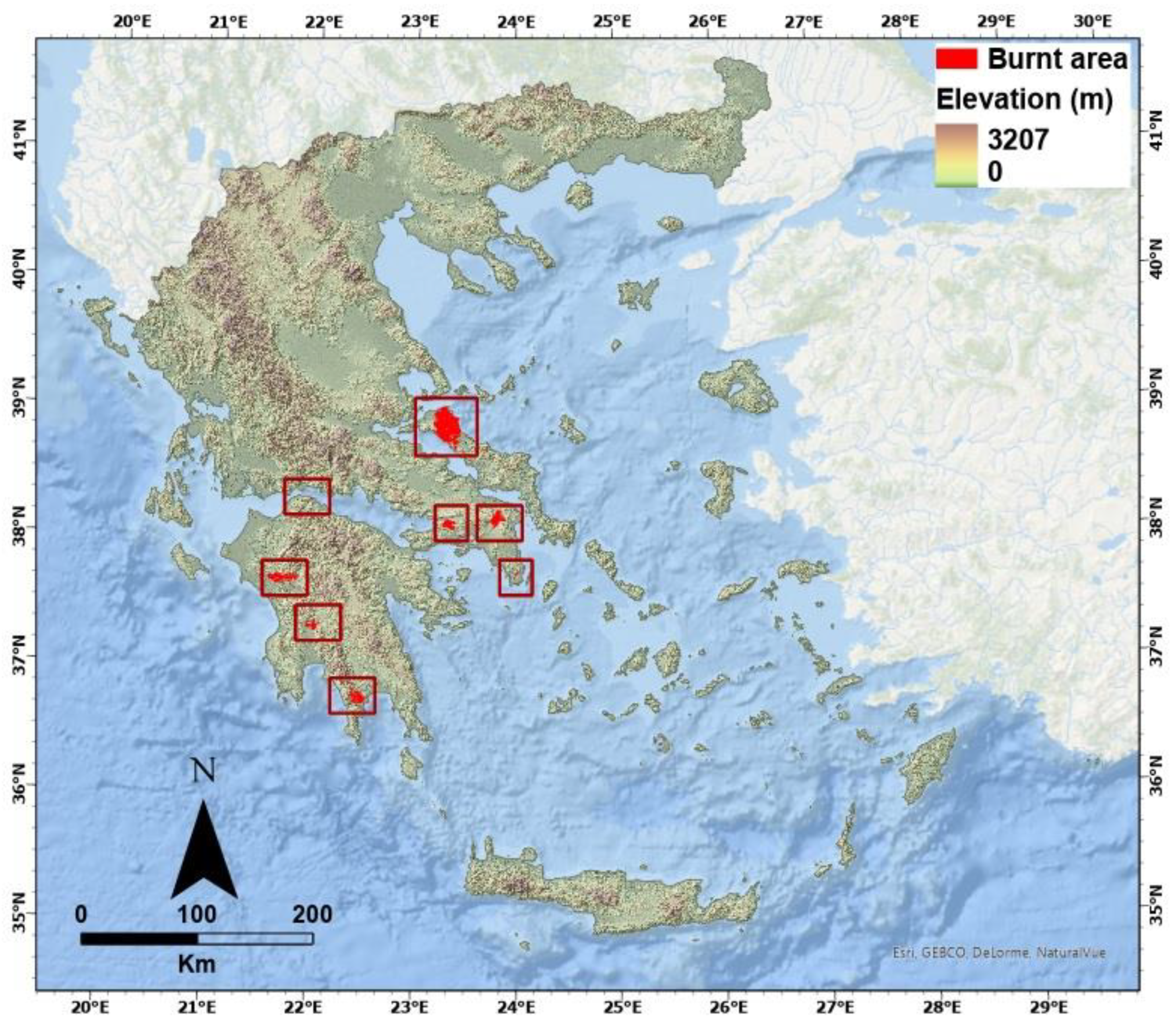
2. Study Areas
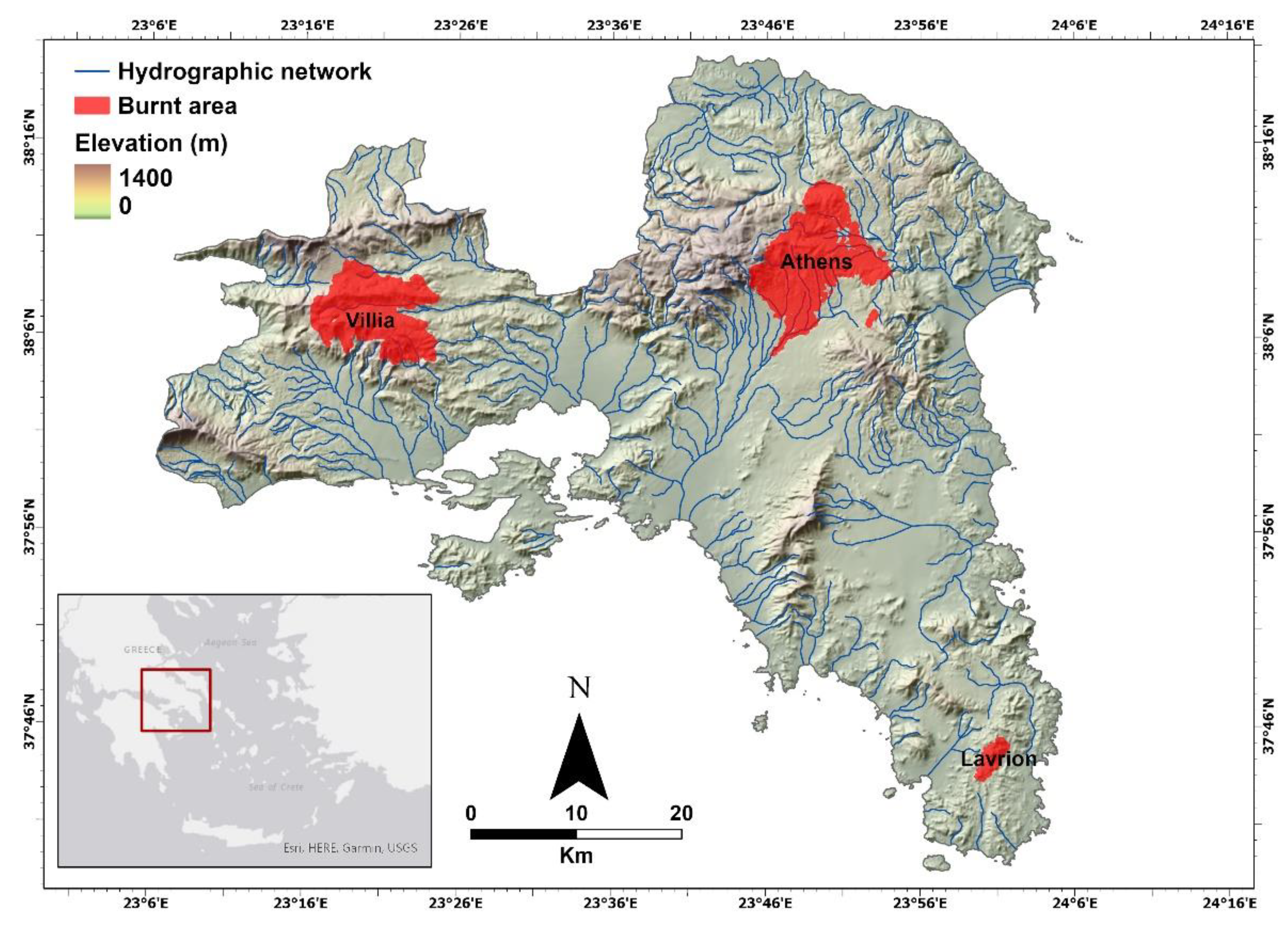
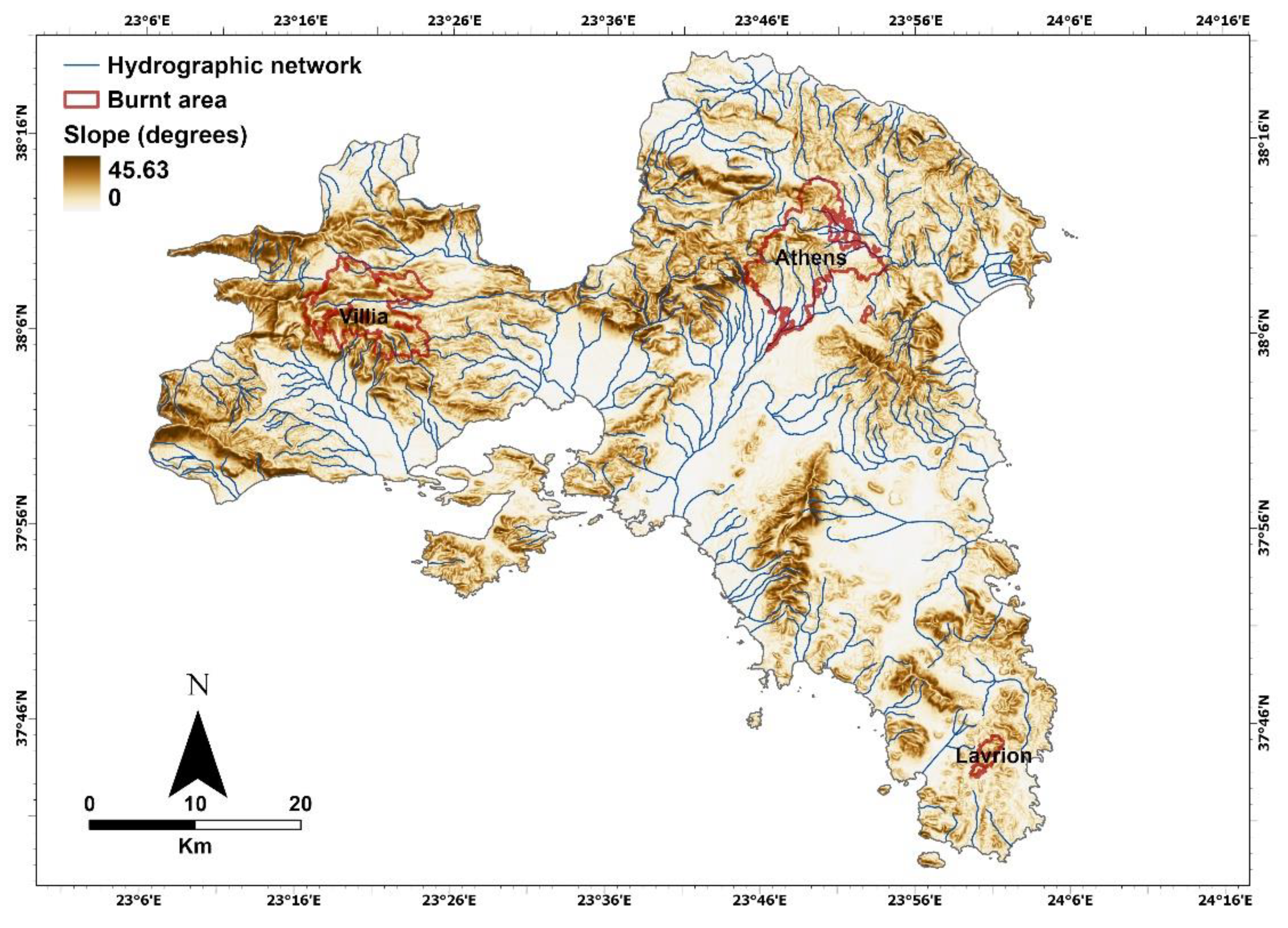
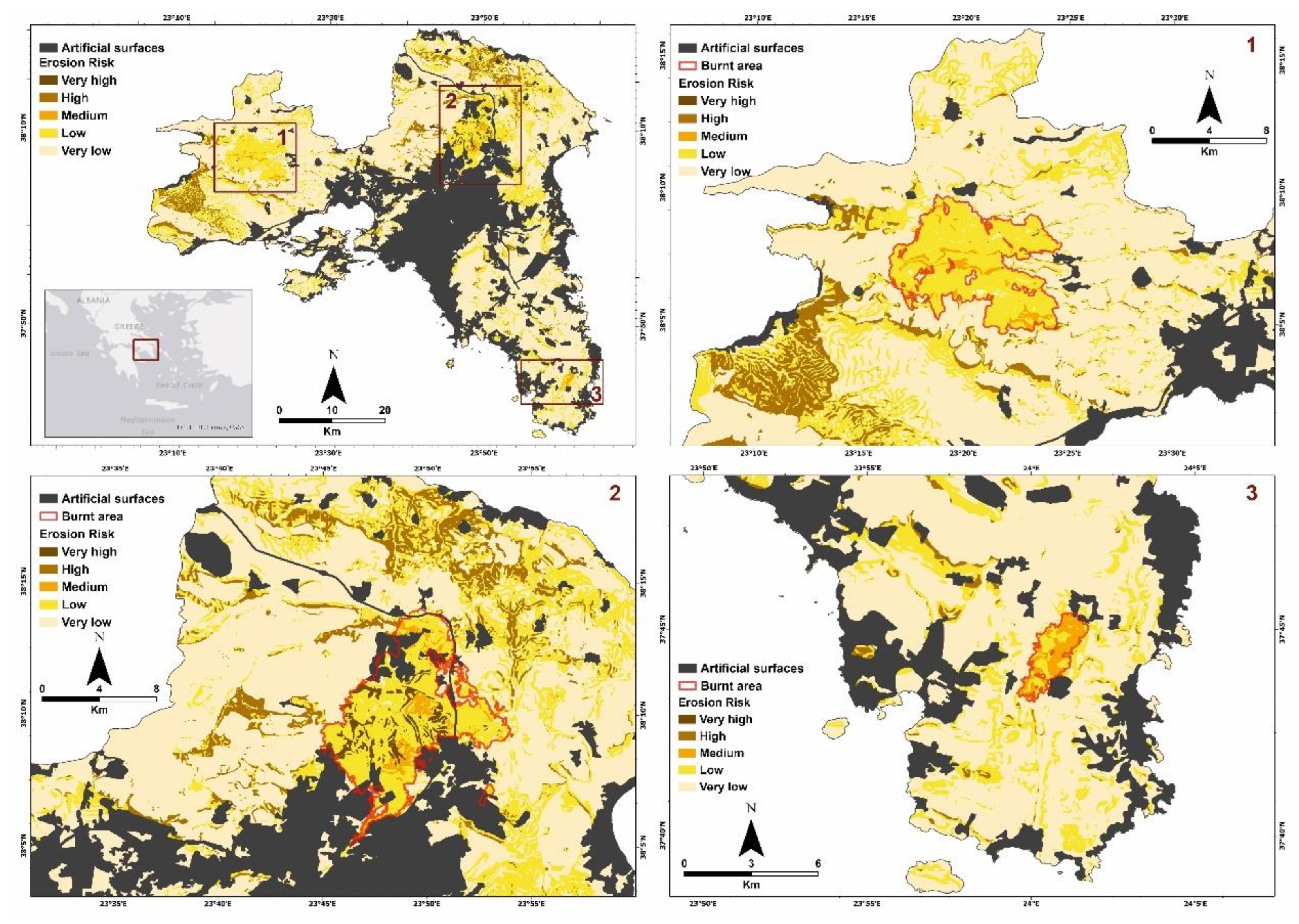
2.1. Attica
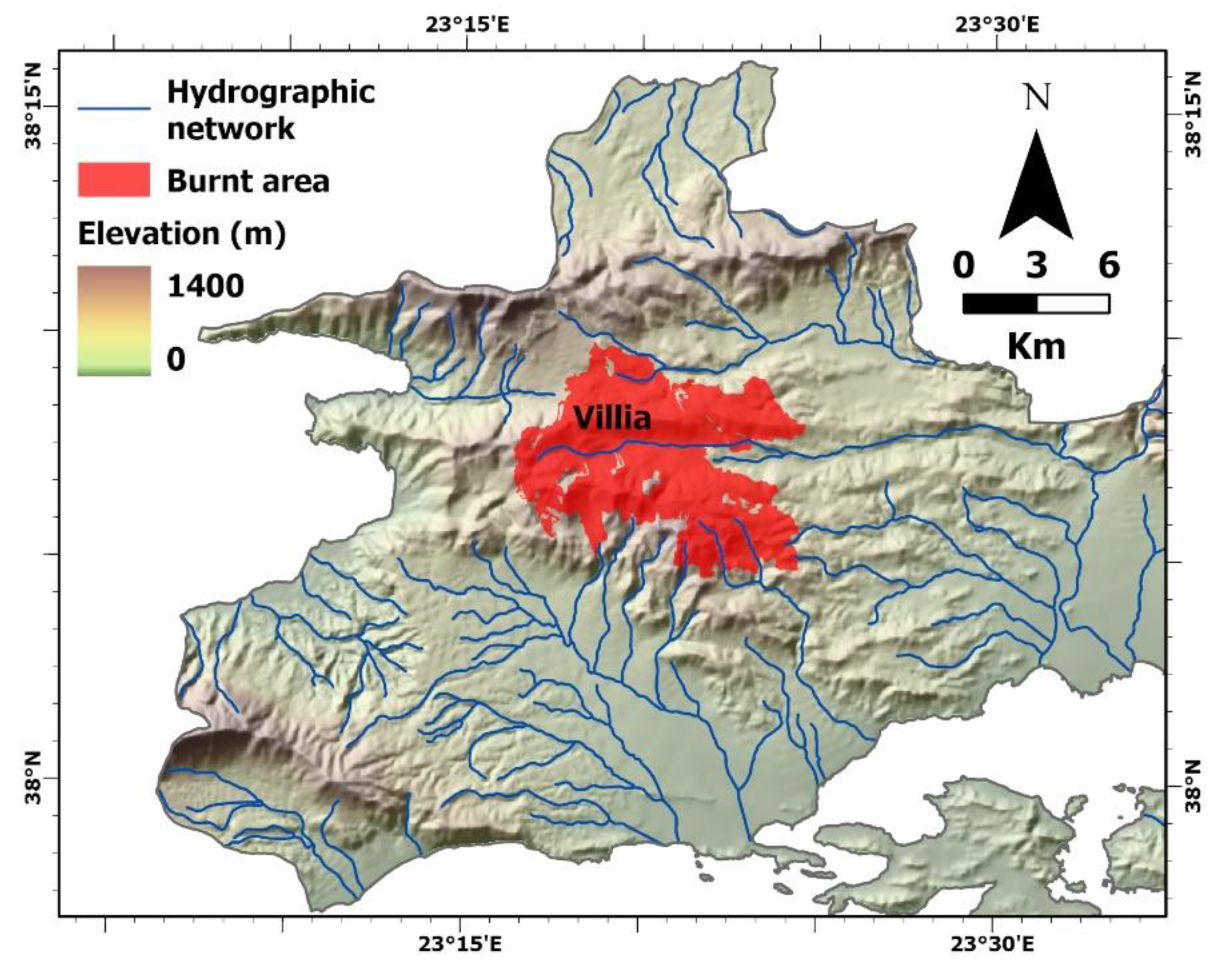
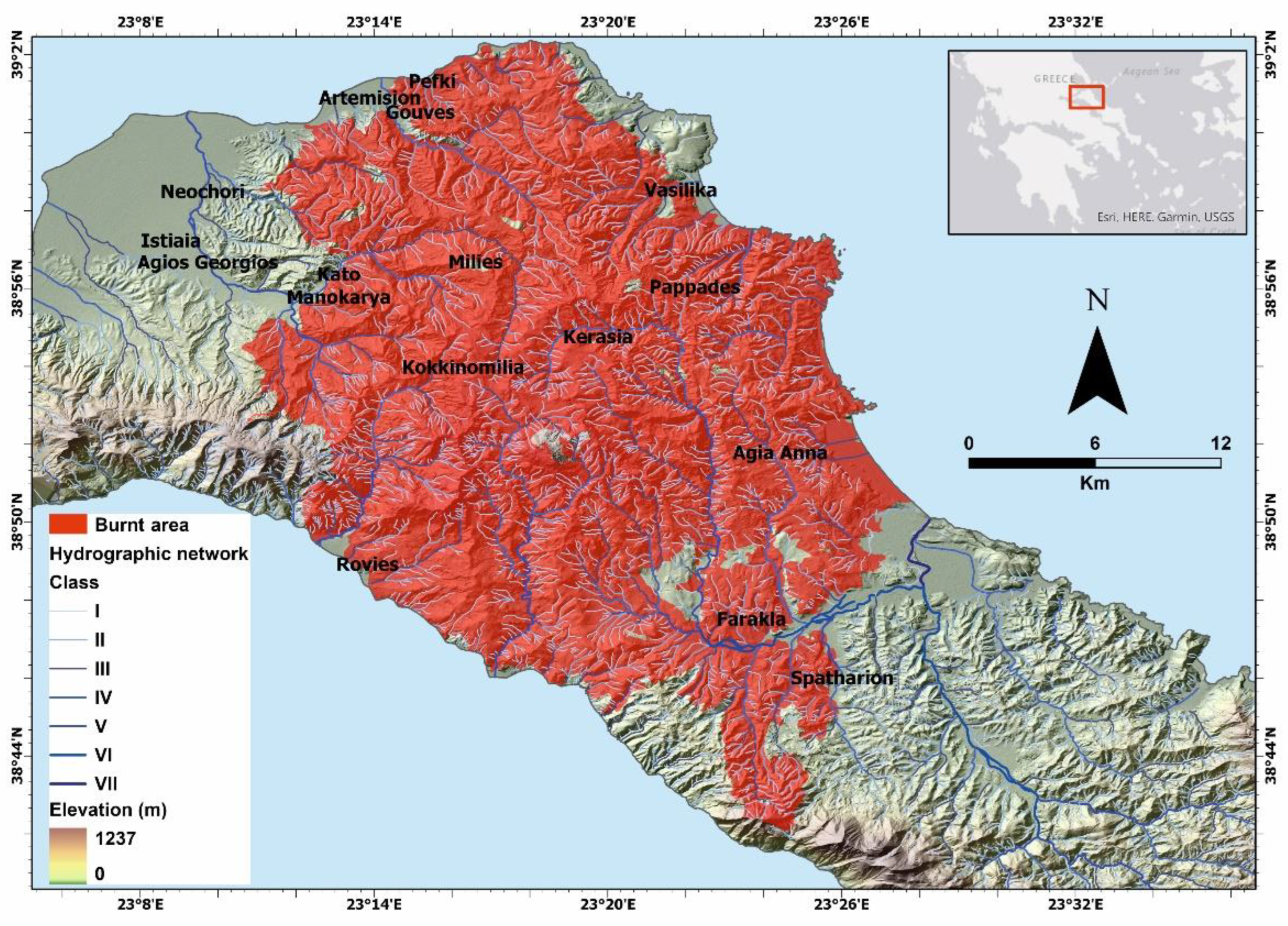
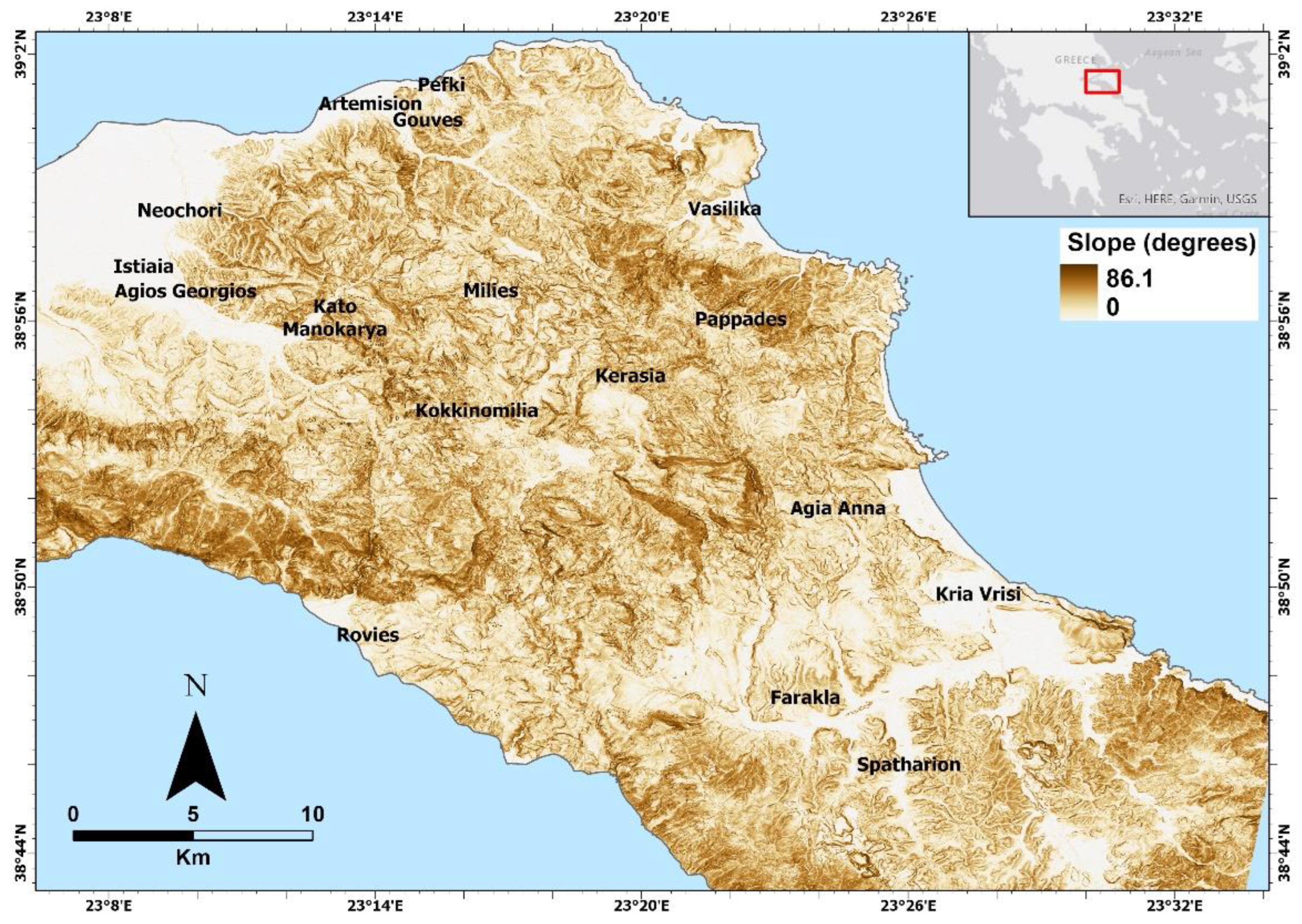
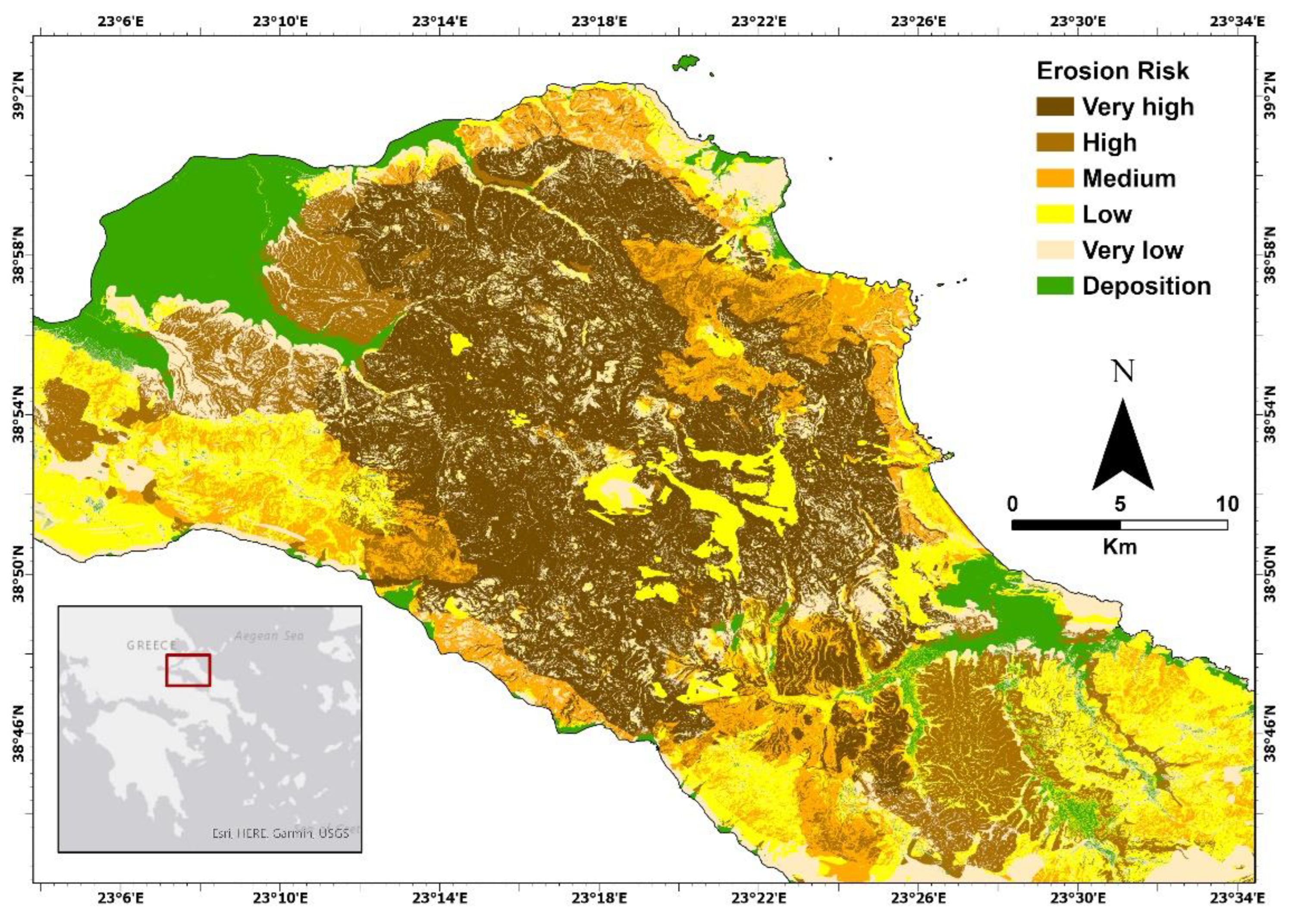
2.2. Northern Euboea
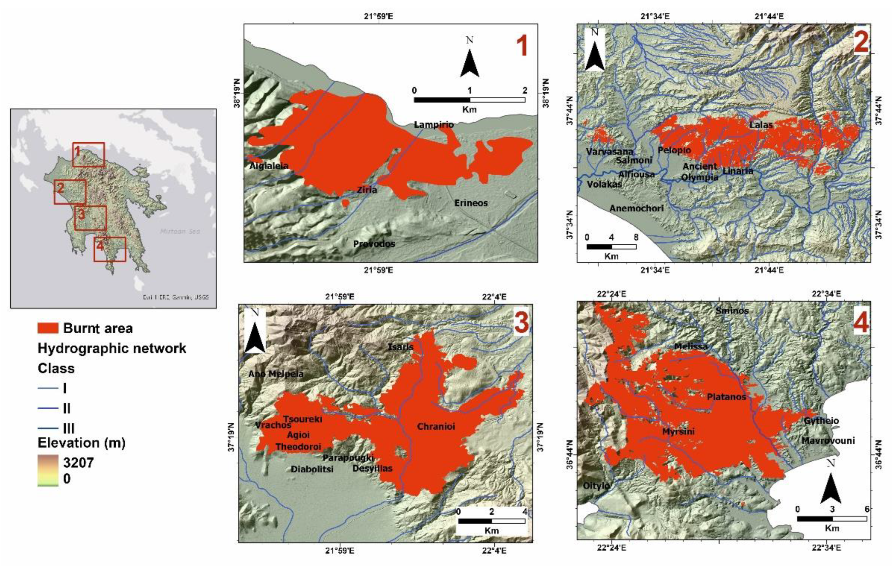
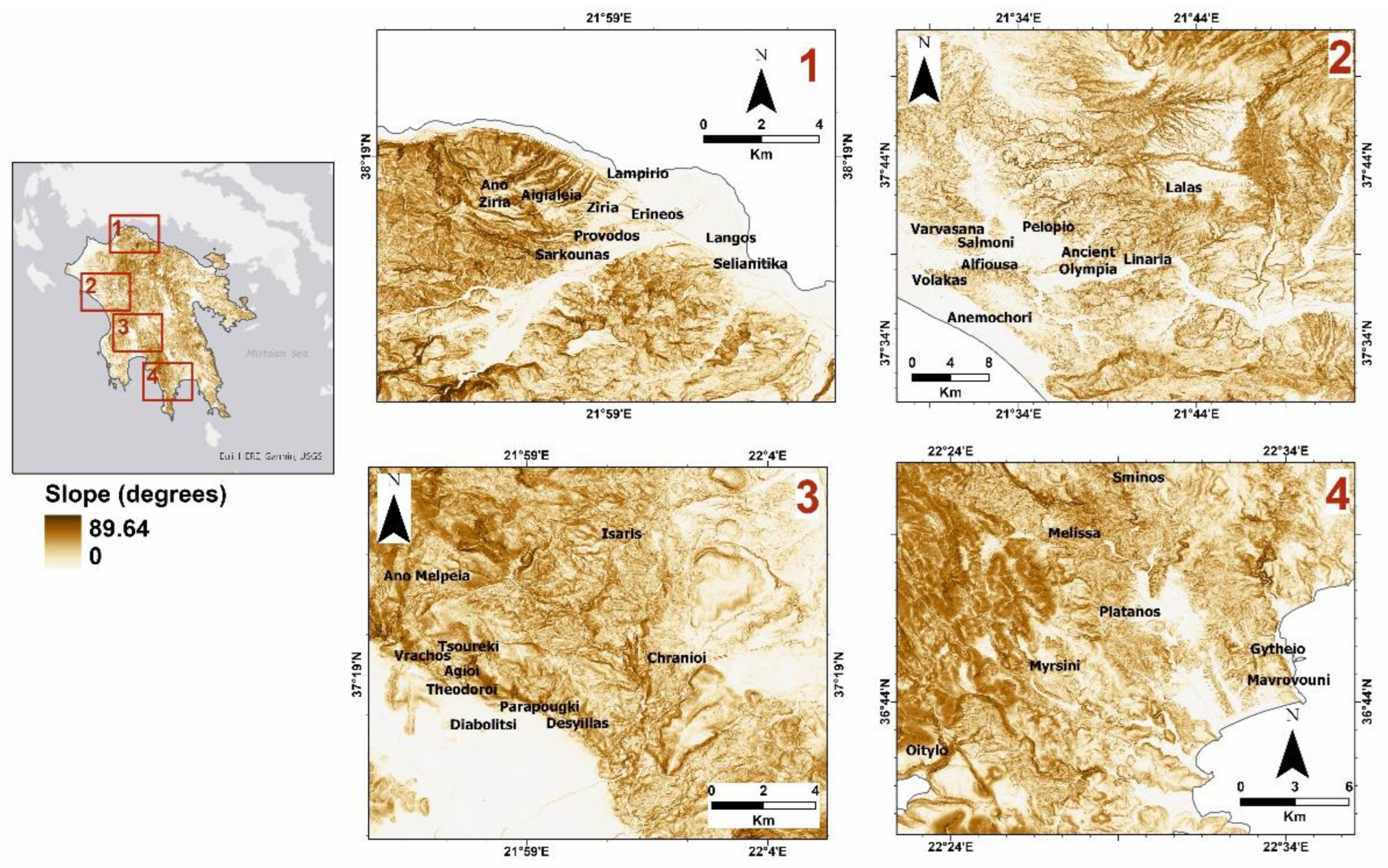
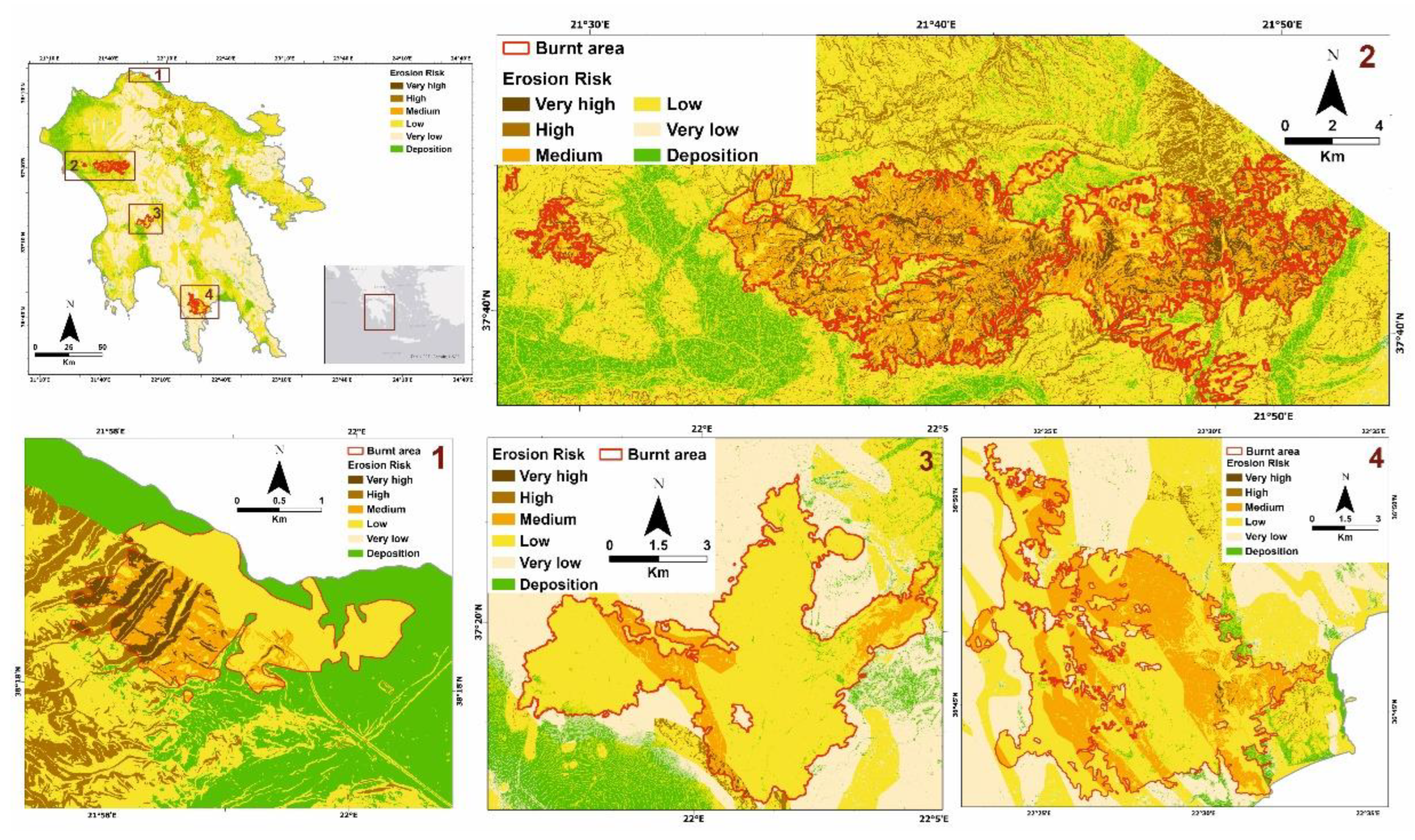
2.3. The Peloponnese
3. Materials and Methods
4. Results and Discussion
5. Conclusions
Supplementary Materials
Author Contributions
Funding
Institutional Review Board Statement
Informed Consent Statement
Acknowledgments
Conflicts of Interest
References
- Lekkas, E.; Parcharidis, I.; Arianoutsou, M.; Lozios, S.; Mavroulis, S.; Spyrou, N.-I.; Antoniou, V.; Nastos, P.; Mavrouli, M.; Speis, P.; et al. The July–August 2021 Wildfires in Greece. Newsl. Environ. Disaster Cris. Manag. Strateg. 2021, 25. [Google Scholar]
- Charlton, R. Fundamentals of Fluvial Geomorphology; Routledge: London, UK, 2007; pp. 1–234. [Google Scholar] [CrossRef]
- Huggett, R.J. Fundamentals of Geomorphology, 3rd ed.; Routledge: London, UK; New York, NY, USA, 2011. [Google Scholar]
- Evelpidou, N. Geomorphology. Laboratory Exercises; Academic Press I. Basdras & Co.: Alexandroupolis, Greece, 2018. [Google Scholar]
- King, D.; Fox, D.M.; Daroussin, J.; Le Bissonnais, Y.; Danneels, V. Upscaling a simple erosion model from small areas to a large region. Nutr. Cycl. Agroecosyst. 1998, 50, 143–149. [Google Scholar] [CrossRef]
- Van Der Knijff, J.M.; Jones, R.J.A.; Montanarella, L. Soil Erosion Risk Assessment in Italy; European Soil Bureau: Brussels, Belgium, 1999. [Google Scholar]
- Grimm, M.; Jones, R.J.A.; Rusco, E.; Montanarella, L. Soil Erosion Risk in Italy: A Revised USLE Approach; European Commission Joint Research Centre: Ispra, Italy, 2003. [Google Scholar]
- Kirkby, M.J.; Jones, R.J.A.; Irvine, B.; Gobin, A.; Govers, G.; Cerdan, O.; Van Rompaey, A.J.; Le Bissonnais, Y.; Daroussin, J.; King, D.; et al. Pan-European Soil Erosion Risk Assessment for Europe: The PESERA map, Version 1 October 2003. Explanation of Special Publication Ispra 2004 No. 73 (SPI); Office for Official Publications of the European Communities: Luxembourg, 2004. [Google Scholar]
- Henin, S.; Gobillot, T. L’érosion en France. Bull. d’informations Tech. 1950, 50, 431–433. [Google Scholar]
- Auzet, A. L’érosion des sols cultivés en France sous l’action du ruissellement. Ann. Georgr. 1987, 537, 529–556. [Google Scholar] [CrossRef]
- Roering, J.J.; Mackey, B.H.; Marshall, J.A.; Sweeney, K.E.; Deligne, N.I.; Booth, A.M.; Handwerger, A.L.; Cerovski-Darriau, C. ‘You are HERE’: Connecting the dots with airborne lidar for geomorphic fieldwork. Geomorphology 2013, 200, 172–183. [Google Scholar] [CrossRef]
- Tarolli, P. High-resolution topography for understanding Earth surface processes: Opportunities and challenges. Geomorphology 2014, 216, 295–312. [Google Scholar] [CrossRef]
- Passalacqua, P.; Belmont, P.; Staley, D.M.; Simley, J.D.; Arrowsmith, J.R.; Bode, C.A.; Crosby, C.; DeLong, S.B.; Glenn, N.F.; Kelly, S.A.; et al. Analyzing high resolution topography for advancing the understanding of mass and energy transfer through landscapes: A review. Earth-Sci. Rev. 2015, 148, 174–193. [Google Scholar] [CrossRef] [Green Version]
- Ardizzone, F.; Cardinali, M.; Galli, M.; Guzzetti, F.; Reichenbach, P. Identification and mapping of recent rainfall-induced landslides using elevation data collected by airborne Lidar. Nat. Hazards Earth Syst. Sci. 2007, 7, 637–650. [Google Scholar] [CrossRef] [Green Version]
- Jaboyedoff, M.; Oppikofer, T.; Abellán, A.; Derron, M.-H.; Loye, A.; Metzger, R.; Pedrazzini, A. Use of LIDAR in landslide investigations: A review. Nat. Hazards 2012, 61, 5–28. [Google Scholar] [CrossRef] [Green Version]
- Pirotti, F. Laser Scanner Applications in Forest and Environmental Sciences. Ital. J. Remote Sens. 2012, 44, 109–123. [Google Scholar] [CrossRef]
- Trevisani, S.; Cavalli, M.; Marchi, L. Surface texture analysis of a high-resolution DTM: Interpreting an alpine basin. Geomorphology 2012, 161–162, 26–39. [Google Scholar] [CrossRef]
- Cavalli, M.; Trevisani, S.; Comiti, F.; Marchi, L. Geomorphometric assessment of spatial sediment connectivity in small Alpine catchments. Geomorphology 2013, 188, 31–41. [Google Scholar] [CrossRef]
- Passalacqua, P.; Hillier, J.; Tarolli, P. Innovative analysis and use of high-resolution DTMs for quantitative interrogation of Earth-surface processes. Earth Surf. Process. Landf. 2014, 39, 1400–1403. [Google Scholar] [CrossRef] [Green Version]
- Smith, M.W.; Vericat, D. From experimental plots to experimental landscapes: Topography, erosion and deposition in sub-humid badlands from Structure-from-Motion photogrammetry. Earth Surf. Process. Landf. 2015, 40, 1656–1671. [Google Scholar] [CrossRef] [Green Version]
- Wischmeier, W.; Smith, D. Predicting Rainfall Erosion Losses: A Guide for Conservation Planning; USDA: Beltsville, MD, USA, 1978. [Google Scholar]
- Desmet, P.J.J.; Govers, G. A GIS procedure for automatically calculating the USLE LS factor on topographically complex landscape units. J. Soil Water Conserv. 1996, 51, 427–433. [Google Scholar]
- Renard, K.G.; United States. Agricultural Research Service. Predicting Soil Erosion by Water: A Guide to Conservation Planning with the revised Universal Soil Loss Equation (RUSLE); US Department of Agriculture, Agricultural Research Service: Washington DC, USA, 1997; ISBN 0160489385. [Google Scholar]
- Angima, S.D.; Stott, D.E.; O’Neill, M.K.; Ong, C.K.; Weesies, G.A. Soil erosion prediction using RUSLE for central Kenyan highland conditions. Agric. Ecosyst. Environ. 2003, 97, 295–308. [Google Scholar] [CrossRef]
- Renard, K.G.; Foster, G.R. Soil Conservation: Principles of Erosion by Water. Dryl. Agric./Ed. H.E. Dregne W.O. Willis. 1983. Available online: https://agris.fao.org/agris-search/search.do?recordID=US201301916151 (accessed on 14 December 2021).
- Kirkby, M.J.; Cox, N.J. A climatic index for soil erosion potential (CSEP) including seasonal and vegetation factors. CATENA 1995, 25, 333–352. [Google Scholar] [CrossRef]
- Kirkby, M.J.; Bissonais, Y.L.; Coulthard, T.J.; Daroussin, J.; McMahon, M.D. The development of land quality indicators for soil degradation by water erosion. Agric. Ecosyst. Environ. 2000, 81, 125–135. [Google Scholar] [CrossRef]
- Burrough, P.A. Fuzzy mathematical methods for soil survey and land evaluation. J. Soil Sci. 1989, 40, 477–492. [Google Scholar] [CrossRef]
- Burrough, P.A.; Macmillan, R.A.; van Deursen, W. Fuzzy classification methods for determining land suitability from soil profile observations and topography. J. Soil Sci. 1992, 43, 193–210. [Google Scholar] [CrossRef]
- Evelpidou, N.; Gournellos, T.; Karkani, A.; Kardara, E. Developing a neuro–fuzzy system to classify drainage sub-basins according to erosion processes on the Island of Lefkas, Greece. Rev. Geomorfol. 2018, 20, 79–89. [Google Scholar] [CrossRef]
- Binaghi, E.; Luzi, L.; Madella, P.; Pergalani, F.; Rampini, A. Slope Instability Zonation: A Comparison Between Certainty Factor and Fuzzy Dempster-Shafer Approaches. Nat. Hazards 1998, 17, 77–97. [Google Scholar] [CrossRef]
- Sabot, V.; Gournelos, T.; Evelpidou, N.; Vassilopoulos, A. Data base and erosion risk map creation at Trichonida lake using fuzzy sets and gis. Bull. Geol. Soc. Greece 2001, 34, 443–450. [Google Scholar]
- Bartkowiak, A.; Gournellos, T.; Evelpidou, N.; Vassilopoulos, A. Self-organizing maps-a helpful tool in clustering areas with similar factors of erosion risk. In Proceedings of the 6th Pan-Hellenic Geographical Congress of the Hellenic Geographical Society, Thessaloniki, Greece, 3–6 October 2002; pp. 87–94. [Google Scholar]
- Evelpidou, N.; Gournellos, T.; Kardara, E.; Karkani, A. Fuzzy modelling of slope erosion by runoff. Case study in Corinth basin, Greece. Rev. Geomorfol. 2018, 20, 34–42. [Google Scholar] [CrossRef]
- Yesilnacar, E.; Topal, T. Landslide susceptibility mapping: A comparison of logistic regression and neural networks methods in a medium scale study, Hendek region (Turkey). Eng. Geol. 2005, 79, 251–266. [Google Scholar] [CrossRef]
- Melchiorre, C.; Matteucci, M.; Azzoni, A.; Zanchi, A. Artificial neural networks and cluster analysis in landslide susceptibility zonation. Geomorphology 2008, 94, 379–400. [Google Scholar] [CrossRef]
- De la Rosa, D.; Moreno, J.A.; Mayol, F.; Bonsón, T. Assessment of soil erosion vulnerability in western Europe and potential impact on crop productivity due to loss of soil depth using the ImpelERO model. Agric. Ecosyst. Environ. 2000, 81, 179–190. [Google Scholar] [CrossRef]
- Behrens, T.; Förster, H.; Scholten, T.; Steinrücken, U.; Spies, E.D.; Goldschmitt, M. Digital soil mapping using artificial neural networks. J. Plant Nutr. Soil Sci. 2005, 168, 21–33. [Google Scholar] [CrossRef]
- Gournellos, T.; Evelpidou, N.; Karkani, A.; Kardara, E. Recognition of erosion risk areas using Neural Network Technology: An application to the Island of Corfu. Rev. Geomorfol. 2018, 20, 56–65. [Google Scholar] [CrossRef]
- Cremers, N.H.D.; Van Dijk, P.; De Roo, P.; Verzandvoort, M. Spatial and temporal variability of soil surface roughness and the application in hydrological and soil erosion modelling. Wiley Online Libr. 1996, 10, 1035–1047. [Google Scholar] [CrossRef]
- Smith, R.E.; Goodrich, D.C.; Unkrich, C.L. Simulation of selected events on the Catsop catchment by KINEROS2 A report for the GCTE conference on catchment scale erosion models. Catena 1999, 37, 457–475. [Google Scholar] [CrossRef]
- Hessel, R.; Jetten, V.; Guanghui, Z. Estimating Manning’s n for steep slopes. Catena 2003, 54, 77–91. [Google Scholar] [CrossRef]
- Moffet, C.A.; Pierson, F.B.; Robichaud, P.R.; Spaeth, K.E.; Hardegree, S.P. Modeling soil erosion on steep sagebrush rangeland before and after prescribed fire. Catena 2007, 71, 218–228. [Google Scholar] [CrossRef]
- Mügler, C.; Planchon, O.; Patin, J.; Weill, S.; Silvera, N.; Richard, P.; Mouche, E. Comparison of roughness models to simulate overland flow and tracer transport experiments under simulated rainfall at plot scale. J. Hydrol. 2011, 402, 25–40. [Google Scholar] [CrossRef]
- Gilley, J.E.; Finkner, S.C. Hydraulic roughness coefhcients as affected by random roughness. Trans. ASAE 1991, 34, 897–0903. [Google Scholar] [CrossRef]
- Mwendera, E.J.; Feyen, J. Estimation of depression storage and Manning’s resistance coefficient from random roughness measurements. Geoderma 1992, 52, 235–250. [Google Scholar] [CrossRef]
- Zobeck, T.M.; Onstad, C.A. Tillage and rainfall effects on random roughness: A review. Soil Tillage Res. 1987, 9, 1–20. [Google Scholar] [CrossRef]
- Reaney, S.M.; Bracken, L.J.; Kirkby, M.J. The importance of surface controls on overland flow connectivity in semi-arid environments: Results from a numerical experimental approach. Hydrol. Process. 2014, 28, 2116–2128. [Google Scholar] [CrossRef] [Green Version]
- Zheng, Z.C.; He, S.Q.; Wu, F.Q. Relationship between soil surface roughness and hydraulic roughness coefficient on sloping farmland. Water Sci. Eng. 2012, 5, 191–201. [Google Scholar] [CrossRef]
- Yan, T.; Wang, Z.; Liao, C.; Xu, W.; Wan, L. Effects of the morphological characteristics of plants on rainfall interception and kinetic energy. J. Hydrol. 2021, 592, 125807. [Google Scholar] [CrossRef]
- Brown, L. Conserving soils. In State of the World; Scientific Publishers: Rajasthan, India, 1984; Volume 53, pp. 53–75. [Google Scholar]
- Antoneli, V.; Rebinski, E.; Bednarz, J.; Rodrigo-Comino, J.; Keesstra, S.; Cerdà, A.; Pulido Fernández, M. Soil Erosion Induced by the Introduction of New Pasture Species in a Faxinal Farm of Southern Brazil. Geosciences 2018, 8, 166. [Google Scholar] [CrossRef] [Green Version]
- Klik, A. Einfluss unterschiedlicher bodenbearbeitung auf oberflachenabfluss, bodenabtrag sowie auf nahrst- off- und pestizidaus-trage. Osterr. Wasser-und Abfallwirtsch. 2003, 55, 89–96. [Google Scholar]
- Komissarov, M.A.; Klik, A. The Impact of No-Till, Conservation, and Conventional Tillage Systems on Erosion and Soil Properties in Lower Austria. Eurasian Soil Sci. 2020, 53, 503–511. [Google Scholar] [CrossRef]
- Shakesby, R.A.; Doerr, S.H.; Walsh, R.P.D. The erosional impact of soil hydrophobicity: Current problems and future research directions. J. Hydrol. 2000, 231–232, 178–191. [Google Scholar] [CrossRef]
- Shakesby, R.A.; Wallbrink, P.J.; Doerr, S.H.; English, P.M.; Chafer, C.J.; Humphreys, G.S.; Blake, W.H.; Tomkins, K.M. Distinctiveness of wildfire effects on soil erosion in south-east Australian eucalypt forests assessed in a global context. For. Ecol. Manag. 2007, 238, 347–364. [Google Scholar] [CrossRef]
- Wondzell, S.M.; King, J.G. Postfire erosional processes in the Pacific Northwest and Rocky Mountain regions. For. Ecol. Manag. 2003, 178, 75–87. [Google Scholar] [CrossRef]
- Certini, G. Effects of fire on properties of forest soils: A review. Oecologia 2005, 143, 1–10. [Google Scholar] [CrossRef]
- Shakesby, R.A.; Doerr, S.H. Wildfire as a hydrological and geomorphological agent. Earth-Sci. Rev. 2006, 74, 269–307. [Google Scholar] [CrossRef]
- Pérez-Cabello, F.; Cerdà, A.; de la Riva, J.; Echeverría, M.T.; García-Martín, A.; Ibarra, P.; Lasanta, T.; Montorio, R.; Palacios, V. Micro-scale post-fire surface cover changes monitored using high spatial resolution photography in a semiarid environment: A useful tool in the study of post-fire soil erosion processes. J. Arid Environ. 2012, 76, 88–96. [Google Scholar] [CrossRef] [Green Version]
- Shakesby, R.A.; Bento, C.P.M.; Ferreira, C.S.S.; Ferreira, A.J.D.; Stoof, C.R.; Urbanek, E.; Walsh, R.P.D. Impacts of prescribed fire on soil loss and soil quality: An assessment based on an experimentally-burned catchment in central Portugal. Catena 2015, 128, 278–293. [Google Scholar] [CrossRef]
- Kutiel, P.; Inbar, M. Fire impacts on soil nutrients and soil erosion in a Mediterranean pine forest plantation. Catena 1993, 20, 129–139. [Google Scholar] [CrossRef]
- Kutiel, P.; Lavee, H.; Segev, M.; Benyamini, Y. The effect of fire-induced surface heterogeneity on rainfall-runoff-erosion relationships in an eastern Mediterranean ecosystem, Israel. Catena 1995, 25, 77–87. [Google Scholar] [CrossRef]
- Stoof, C.R.; Ferreira, A.J.D.; Mol, W.; Van den Berg, J.; De Kort, A.; Drooger, S.; Slingerland, E.C.; Mansholt, A.U.; Ferreira, C.S.S.; Ritsema, C.J. Soil surface changes increase runoff and erosion risk after a low–moderate severity fire. Geoderma 2015, 239–240, 58–67. [Google Scholar] [CrossRef]
- Cannon, S.H.; Gartner, J.E.; Rupert, M.G.; Michael, J.A.; Rea, A.H.; Parrett, C. Predicting the probability and volume of postwildfire debris flows in the intermountain western United States. GSA Bull. 2010, 122, 127–144. [Google Scholar] [CrossRef]
- Cerda, A.; Robichaud, P.R. Fire Effects on Soil Infiltration. In Fire Effects on Soils and Restoration Strategies; CRC Press: Boca Raton, FL, USA, 2009; pp. 97–120. [Google Scholar] [CrossRef]
- Smith, H.G.; Sheridan, G.J.; Lane, P.N.J.; Nyman, P.; Haydon, S. Wildfire effects on water quality in forest catchments: A review with implications for water supply. J. Hydrol. 2011, 396, 170–192. [Google Scholar] [CrossRef]
- Morales, H.A.; Návar, J.; Domínguez, P.A. The effect of prescribed burning on surface runoff in a pine forest stand of Chihuahua, Mexico. For. Ecol. Manag. 2000, 137, 199–207. [Google Scholar] [CrossRef]
- Benavides-Solorio, J.; MacDonald, L.H. Post-fire runoff and erosion from simulated rainfall on small plots, Colorado Front Range. Hydrol. Process. 2001, 15, 2931–2952. [Google Scholar] [CrossRef]
- Cootei, D.; Malcolm-mcgo, C.; Wall, G.; Dickinsons, W.; Ano, W. Seasonal variation of erodibility indices based on shear strength and aggregate stability in some Ontario soils. Can. J. Soil Sci. 1988, 68. [Google Scholar] [CrossRef]
- Martin, D.A.; Moody, J.A. Comparison of soil infiltration rates in burned and unburned mountainous watersheds. Hydrol. Process. 2001, 15, 2893–2903. [Google Scholar] [CrossRef]
- Alauzis, M.V.; Mazzarino, M.J.; Raffaele, E.; Roselli, L. Wildfires in NW Patagonia: Long-term effects on a Nothofagus forest soil. For. Ecol. Manag. 2004, 192, 131–142. [Google Scholar] [CrossRef]
- García-Corona, R.; Benito, E.; de Blas, E.; Varela, M.E.; García-Corona, R.; Benito, E.; de Blas, E.; Varela, M.E. Effects of heating on some soil physical properties related to its hydrological behaviour in two north-western Spanish soils. Int. J. Wildl. Fire 2004, 13, 195–199. [Google Scholar] [CrossRef]
- Keeley, J.E. Fire intensity, fire severity and burn severity: A brief review and suggested usage. Int. J. Wildl. Fire 2009, 18, 116–126. [Google Scholar] [CrossRef]
- Stoof, C.R.; Vervoort, R.W.; Iwema, J.; VanDenElsen, E.; Ferreira, A.J.D.; Ritsema, C.J. Hydrological response of a small catchment burned by experimental fire. Hydrol. Earth Syst. Sci. 2012, 16, 267–285. [Google Scholar] [CrossRef] [Green Version]
- Mataix-Solera, J.; Cerdà, A.; Arcenegui, V.; Jordán, A.; Zavala, L.M. Fire effects on soil aggregation: A review. Earth-Sci. Rev. 2011, 109, 44–60. [Google Scholar] [CrossRef]
- Aznar, J.M.; González-Pérez, J.A.; Badía, D.; Martí, C. At What Depth Are The Properties of a Gypseous Forest Topsoil Affected By Burning? Land Degrad. Dev. 2016, 27, 1344–1353. [Google Scholar] [CrossRef]
- Wells, C.; Campbell, R.; Debano, L.; Lewis, C.; Predriksen, R.; Franklin, E.; Froelich, R.; Dunn, P. Effects of Fire on Soil: A State of Knowledge Review; General Technical Report WO-7; U.S. Department of Agriculture, Forest Service: Washington, DC, USA, 1979. [Google Scholar]
- Fernández, C.; Vega, J.A.; Jiménez, E.; Vieira, D.C.S.; Merino, A.; Ferreiro, A.; Fonturbel, T. Seeding and mulching + seeding effects on post-fire runoff, soil erosion and species diversity in Galicia (NW Spain). Land Degrad. Dev. 2012, 23, 150–156. [Google Scholar] [CrossRef]
- Prats, S.A.; MacDonald, L.H.; Monteiro, M.; Ferreira, A.J.D.; Coelho, C.O.A.; Keizer, J.J. Effectiveness of forest residue mulching in reducing post-fire runoff and erosion in a pine and a eucalypt plantation in north-central Portugal. Geoderma 2012, 191, 115–124. [Google Scholar] [CrossRef]
- Pereira, P.; Francos, M.; Brevik, E.C.; Ubeda, X.; Bogunovic, I. Post-fire soil management. Curr. Opin. Environ. Sci. Health 2018, 5, 26–32. [Google Scholar] [CrossRef]
- Hellenic National Meteorological Service. Available online: http://www.emy.gr/emy/el/climatology/climatology_city (accessed on 16 December 2021).
- EEA Corine Land Cover (CLC) 2018. Available online: https://land.copernicus.eu/pan-european/corine-land-cover/clc2018 (accessed on 14 November 2021).
- Gawthorpe, R.L.; Leeder, M.R.; Kranis, H.; Skourtsos, E.; Andrews, J.E.; Henstra, G.A.; Mack, G.H.; Muravchik, M.; Turner, J.A.; Stamatakis, M. Tectono-sedimentary evolution of the Plio-Pleistocene Corinth rift, Greece. Basin Res. 2018, 30, 448–479. [Google Scholar] [CrossRef] [Green Version]
- Boardman, J.; Poesen, J. Soil Erosion in Europe. Available online: https://books.google.gr/books?hl=el&lr=&id=vvOFRskFunwC&oi=fnd&pg=PR7&dq=Soil+Erosion+in+Europe&ots=ipm-ALPCXM&sig=Gc43BQVyZxzFN1JbNQlbWEcDm38&redir_esc=y#v=onepage&q=SoilErosioninEurope&f=false (accessed on 20 November 2021).
- Kepner, W.; Rubio, J.; Mouat, D.; Pedrazzini, F. Desertification in the Mediterranean Region. A Security Issue. In Proceedings of the NATO Mediterranean Dialogue Workshop, Valencia, Spain, 2–5 December 2006. [Google Scholar]
- Grove, A.; Rackham, O. The Nature of Mediterranean Europe: An Ecological History; Yale University Press: New Haven, CT, USA, 2003. [Google Scholar]
- van der Knijff, J.M.; Jones, R.J.A.; Montanarella, L. Soil Erosion Risk Assessment in Europe; Office for Official Publications of the European Communities: Luxembourg, 2000. [Google Scholar]
- Blondel, J. The “design” of Mediterranean landscapes: A millennial story of humans and ecological systems during the historic period. Hum. Ecol. 2006, 34, 713–729. [Google Scholar] [CrossRef]
- Lasanta, T.; Nadal-Romero, E.; Errea, M.P. The footprint of marginal agriculture in the Mediterranean mountain landscape: An analysis of the Central Spanish Pyrenees. Sci. Total Environ. 2017, 599–600, 1823–1836. [Google Scholar] [CrossRef] [PubMed]
- CORINE. Soil Erosion Risk and Important Land Resources in the Southern Regions of the European Community; European Environment Agency: Luxembourg, 1992. [Google Scholar]
- RIVM. The Environment in Europe: A global Perspective; RIVM: Bilthoven, The Netherlands, 1992. [Google Scholar]
- Wilson, E. Engineering Hydrology, 4th ed.; MacMillan Press Ltd.: London, UK, 1990. [Google Scholar]
- Smith, K.; Ward, R. Floods: Physical Processes and Human Impacts; Wiley: Hoboken, NJ, USA, 1998; ISBN 978-0-471-95248-0. [Google Scholar]
- Ward, R.; Robinson, M. Principles of Hydrology, 4th ed.; McGraw-Hill: London, UK, 2000. [Google Scholar]
- Diakakis, M. Flood Hazard Assessment with the Use of Modeling Techniques; National and Kapodistrian University of Athens: Athens, Greece, 2012. [Google Scholar]


Publisher’s Note: MDPI stays neutral with regard to jurisdictional claims in published maps and institutional affiliations. |
© 2021 by the authors. Licensee MDPI, Basel, Switzerland. This article is an open access article distributed under the terms and conditions of the Creative Commons Attribution (CC BY) license (https://creativecommons.org/licenses/by/4.0/).
Share and Cite
Evelpidou, N.; Tzouxanioti, M.; Gavalas, T.; Spyrou, E.; Saitis, G.; Petropoulos, A.; Karkani, A. Assessment of Fire Effects on Surface Runoff Erosion Susceptibility: The Case of the Summer 2021 Forest Fires in Greece. Land 2022, 11, 21. https://0-doi-org.brum.beds.ac.uk/10.3390/land11010021
Evelpidou N, Tzouxanioti M, Gavalas T, Spyrou E, Saitis G, Petropoulos A, Karkani A. Assessment of Fire Effects on Surface Runoff Erosion Susceptibility: The Case of the Summer 2021 Forest Fires in Greece. Land. 2022; 11(1):21. https://0-doi-org.brum.beds.ac.uk/10.3390/land11010021
Chicago/Turabian StyleEvelpidou, Niki, Maria Tzouxanioti, Theodore Gavalas, Evangelos Spyrou, Giannis Saitis, Alexandros Petropoulos, and Anna Karkani. 2022. "Assessment of Fire Effects on Surface Runoff Erosion Susceptibility: The Case of the Summer 2021 Forest Fires in Greece" Land 11, no. 1: 21. https://0-doi-org.brum.beds.ac.uk/10.3390/land11010021